Showing 30466 items matching "s "
-
 Eltham District Historical Society Inc
Photograph - Aerial Photograph, Landata, Eltham, Vic, Jan. 1951
Centred on Allison Crecent Reserve, Sherbrook Road and Scenic Crescent, Eltham bounded by Allendale Road to north, Dudley Street to south, Zig Zag Road to east and St Helena Road to west. Historic Aerial Imagery Source: Landata.vic.gov.au Aerial Photo Details: Project No :65 Project : MELBOURNE AND METROPOLITAN PROJECT NO. 2 Run : 7 Frame : 10 Date : 01/1951 Film Type : B/W Camera : EAG9 Flying Height : 12200 Scale : 12000 Film Number : 1419 GDA2020 : 37°42'14"S, 145°08'36"E MGA2020 : 336339, 5825416 (55) Melways : 21 H2 (ed. 42)Historical aerial photos and photo maps provide viusal evidence of the chronology of changes to the built landscape of the district and assist in dating other imagesaerial photo, 1951-01, eltham, neil webster collection, allendale road, allison crecent reserve, dudley street, melway 21h2, scenic crescent, sherbrook road, st helena road, zig zag road -
 Eltham District Historical Society Inc
Photograph - Aerial Photograph, Landata, Montmorency, Feb. 1956
Centred on present day Grand Boulevard and Olympic Way, Montmorency bounded by Diamond Street to north, Old Eltham Road and Eltham Lower Park to south, Bible Street to east and Para Road to west. Historic Aerial Imagery Source: Landata.vic.gov.au Aerial Photo Details: Project No :250 Project : MELBOURNE OUTER SUBURBS PROJECT Run : 17 Frame : 115 Date : 02/1956 Film Type : B/W Camera : EAG9 Flying Height : 10000 Scale : 12000 Film Number : 1176 GDA2020 : 37°43'24"S, 145°07'55"E MGA2020 : 335375, 5823236 (55) Melways : 21 F7 (ed. 42)aerial photo, 1956-02, neil webster collection, eltham, main road, montmorency, bible street, diamond street, eltham lower park, grand boulevard, melway 21f7, old eltham road, olympic way, para road -
 Eltham District Historical Society Inc
Photograph - Aerial Photograph, Landata, Eltham, Feb. 1956
Centred on present day Mount Plaeasant Road near Dalton Street, Eltham bounded by Luck Street to north, Eltham Lower Park to south, Reynolds Road to east and Central Park to west Historic Aerial Imagery Source: Landata.vic.gov.au Aerial Photo Details: Project No :250 Project : MELBOURNE OUTER SUBURBS PROJECT Run : 18 Frame : 93 Date : 02/1956 Film Type : B/W Camera : EAG9 Flying Height : 10000 Scale : 12000 Film Number : 1176 GDA2020 : 37°43'02"S, 145°09'38"E MGA2020 : 337871, 5823961 (55) Melways : 22 B6 (ed. 42)aerial photo, 1956-02, neil webster collection, eltham, central park, eltham lower park, luck street, melway 22b6, nyora road, reynolds road, dalton street, mount pleasant road -
 Eltham District Historical Society Inc
Photograph - Aerial Photograph, Landata, Eltham, Vic, Feb. 1956
Centred on present day Parsons Avenue at Leane Drive near the Maroondah Aqueduct, Eltham bounded by Lorimer Road to north, Thompson Crescent and Norman Road to south, Bells Hill Road to east and Parsons Road to west Historic Aerial Imagery Source: Landata.vic.gov.au Aerial Photo Details: Project No :250 Project : MELBOURNE OUTER SUBURBS PROJECT Run : 19 Frame : 5 Date : 02/1956 Film Type : B/W Camera : EAG9 Flying Height : 10000 Scale : 12000 Film Number : 1176 GDA2020 : 37°42'04"S, 145°11'09"E MGA2020 : 340064, 5825786 (55) Melways : 22 H1 (ed. 42)aerial photo, 1956-02, neil webster collection, allendale road, bells hill road, eltham, leane drive, lorimer road, maroondah aqueduct, melway 22h1, norman road, parsons road, research (vic.), thompson crescent -
 Eltham District Historical Society Inc
Photograph - Aerial Photograph, Landata, Eltham, Vic, Apr. 1963
Centred on present day Zig Zag Road and Main Road, Eltham bounded by Maroondah Aqueduct to north, Thompson Crescent and Arthur Street to south, Parsons Road to east and Glen Park Road and Banks Road to west. Historic Aerial Imagery Source: Landata.vic.gov.au Aerial Photo Details: Project No :486 Project : MELBOURNE (1963) PROJECT Run : 5 Frame : 59 Date : 04/1963 Film Type : B/W Camera : RC8 Flying Height : 5100 Scale : 9600 Film Number : 1805 GDA2020 : 37°42'24"S, 145°08'52"E MGA2020 : 336716, 5825114 (55) Melways : 21 J3 (ed. 42)aerial photo, neil webster collection, eltham, 1963-04, arthur street, banks road, glen park road, maroondah aqueduct, melway 21j3, parsons road -
 Eltham District Historical Society Inc
Photograph - Aerial Photograph, Landata, Eltham, Vic, Apr. 1963
Centred on present day Floriston Grove, Eltham bounded by Maroondah Aqueduct to north, Thompson Crescent and Diosma Road to south, Research Shops to east and Glen Park Road and Park West Road to west. Historic Aerial Imagery Source: Landata.vic.gov.au Aerial Photo Details: Project No :486 Project : MELBOURNE (1963) PROJECT Run : 5 Frame : 60 Date : 04/1963 Film Type : B/W Camera : RC8 Flying Height : 5100 Scale : 9600 Film Number : 1805 GDA2020 : 37°42'24"S, 145°09'29"E MGA2020 : 337622, 5825128 (55) Melways : 22 B3 (ed. 42)aerial photo, neil webster collection, eltham, 1963-04, diosma road, floriston grove, maroondah aqueduct, melway 22b3, park west road, research (vic.), research shops -
 Eltham District Historical Society Inc
Photograph - Aerial Photograph, Landata, Lower Plenty, Vic, Apr. 1963
Centred on present day Old Eltham Road near Araluen Centre, Lower Plenty bounded by Cromwell Street to north, Yarra River to south, Main Road at Mount Pleasant Road to east and Panorama Avenue to west. Historic Aerial Imagery Source: Landata.vic.gov.au Aerial Photo Details: Project No :486 Project : MELBOURNE (1963) PROJECT Run : 7 Frame : 231 Date : 04/1963 Film Type : B/W Camera : RC8 Flying Height : 5100 Scale : 9600 Film Number : 1805 GDA2020 : 37°44'03"S, 145°07'56"E MGA2020 : 335420, 5822027 (55) Melways : 21 F10 (ed. 42)aerial photo, neil webster collection, 1963-04, araluen, cromwell street, eltham, lower plenty, main road, melway 21f10, mount pleasant road, old eltham road, panorama avenue, yarra river -
 Eltham District Historical Society Inc
Photograph - Aerial Photograph, Landata, Eltham, Vic, Apr. 1963
Centred on present day Eltham Lower Park bounded by Brougham Street to north, Yarra River and Fitzsimons Lane Bridge to south, Main Road at Kent Hughes Road to east and Bolton Street to west. Historic Aerial Imagery Source: Landata.vic.gov.au Aerial Photo Details: Project No :486 Project : MELBOURNE (1963) PROJECT Run : 7 Frame : 232 Date : 04/1963 Film Type : B/W Camera : RC8 Flying Height : 5100 Scale : 9600 Film Number : 1805 GDA2020 : 37°44'03"S, 145°08'33"E MGA2020 : 336329, 5822040 (55) Melways : 21 H10 (ed. 42)aerial photo, neil webster collection, 1963-04, bolton steet, brougham steet, eltham, eltham lower park, fitzsimons lane bridge, kent hughes road, melway 21h10, yarra river -
 Eltham District Historical Society Inc
Photograph - Aerial Photograph, Landata, Eltham North, Vic, Apr. 1972
Centred on present day Eltham North reserve near Eltham North Primary School, Eltham North bounded by Allendale Road to north, Bellevue Road to south, Zig Zag Road and Beard Street to east and Ryans Road to west. Historic Aerial Imagery Source: Landata.vic.gov.au Aerial Photo Details: Project No :985 Project : MELBOURNE 1972 Run : 26 Frame : 190 Date : 04/1972 Film Type : B/W Camera : RC10 Flying Height : 5700 Scale : 9600 Film Number : 2636 GDA2020 : 37°41'52"S, 145°08'52"E MGA2020 : 336705, 5826102 (55) Melways : 11 J12 (ed. 42)aerial photo, neil webster collection, 1972-04, allendale road, beard street, bellevue road, eltham, eltham north, eltham north reserve, melway 11j12, ryans road, zig zag road, eltham north primary school -
 Eltham District Historical Society Inc
Photograph - Aerial Photograph, Landata, Research, Vic, Apr. 1972
Centred on present day Main Road, Research near Maroondah Aqueduct and Eltham College bounded by Allendale Road to north, Research-Warrandyte Road to south, Swipers Gully Training Restaurant to east and Reynolds Road to west. Historic Aerial Imagery Source: Landata.vic.gov.au Aerial Photo Details: Project No :985 Project : MELBOURNE 1972 Run : 26 Frame : 194 Date : 04/1972 Film Type : B/W Camera : RC10 Flying Height : 5700 Scale : 9600 Film Number : 2636 GDA2020 : 37°42'07"S, 145°11'07"E MGA2020 : 340015, 5825692 (55) Melways : 22 H1 (ed. 42)aerial photo, neil webster collection, 1972-04, allendale road, eltham college, main road, maroondah aqueduct, melway 22h1, research (vic.), research-warrandyte road, reynolds road, swiper's gully -
 Eltham District Historical Society Inc
Photograph - Aerial Photograph, Landata, Eltham, Vic, Apr. 1972
Centred on present day Diamond Creek Trail at the Eltham Leisure Centre bounded by Central Park to north, Main Road at Falkiner Street to south, MacMahon Ball Paddock to east and Grand Boulevard at Buena Vista Drive to west. Historic Aerial Imagery Source: Landata.vic.gov.au Aerial Photo Details: Project No :985 Project : MELBOURNE 1972 Run : 28 Frame : 207 Date : 04/1972 Film Type : B/W Camera : RC10 Flying Height : 5700 Scale : 9600 Film Number : 2635 GDA2020 : 37°43'25"S, 145°08'20"E MGA2020 : 335985, 5823223 (55) Melways : 21 G7 (ed. 42)aerial photo, neil webster collection, 1972-04, eltham, buena vista drive, central park, diamond creek trail, eltham leisure centre, falkiner street, grand boulevard, macmahon ball paddock, main road, melway 21g7 -
 Eltham District Historical Society Inc
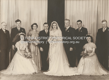
Photograph, Michael Doolay, Wedding of Leslie Ernest Shillinglaw and Alva Elizabeth Thomas, 1949
Standing L-R: Ernest Samuel Shillinglaw, John Thomas, Min Bergin, Leslie Ernest Shillinglaw, Alva Shillinglaw (Nee Thomas), Doug Way, Don Richards, Cecil Thomas Seated L-R: Frances Thomas, Melva Richards (nee Shillinglaw) ENGAGEMENTS The Engagement is announced of Alva Elizabeth, daughter of Mr. and Mrs. C. J. Thomas, Mt. Eliza, to Leslie Ernest, only son of Mr. and Mrs. E. S. Shillinglaw, Healesville. Family Notices (1948, November 13). Healesville Guardian (Lilydale, Vic. : 1942 - 1954), p. 2. Retrieved December 4, 2022, from http://nla.gov.au/nla.news-article60678669marg ball collection, 1949, alva elizabeth shillinglaw (nee thomas), cecil thomas, don richards, doug way, ernest samuel shillinglaw (1888-1958), frances thomas, john thomas, leslie ernest shillinglaw, melva lucy richards (nee shillinglaw), melva lucy shillinglaw, min bergin, wedding -
 Eltham District Historical Society Inc
Photograph - Aerial Photograph, Landata, Eltham, Main Road; Mt Pleasant Rd to Railway Rd, Dec. 1945
Centred on Main Rd and Henry St, Eltham bounded by Railway Road to north, Mount Pleasant Road at Main Road to south, top of the hill in Arthur Street to east and Karingal Drive at Sherbourne Road to west. Historic Aerial Imagery Source: Landata.vic.gov.au Aerial Photo Details: Project No :65 Project : MELBOURNE AND METROPOLITAN PROJECT NO. 2 Run : 8 Frame : 70 Date : 01/1951 Film Type : B/W Camera : EAG9 Flying Height : 12200 Scale : 12000 Film Number : 1419 GDA2020 : 37°43'06"S, 145°08'45"E MGA2020 : 336589, 5823811 (55) Melways : 21 J6 (ed. 42)aerial photo, eltham, main road, henry street, arthur street, bolton street, eltham-yarra glen road, neil webster collection, 1951-01, dave lyon house, ernie andrew house, karingal road, melway 21j6, mount pleasant road, railway road -
 Eltham District Historical Society Inc
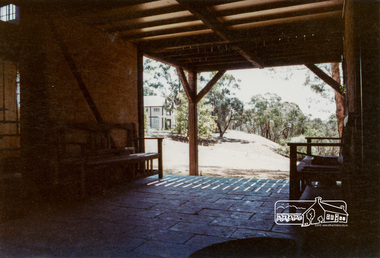
Photograph, The Jelbart Barn, 93 Arthur Street, Eltham, 1972c
Owned at the time by architect, Ian Jelbart, the property had been in the Jelbart family since the 1940s; a 5560sqm secluded hilltop parcel in Eltham. When the manor house and its barn were built, Eltham was a rural community; Jelbart’s grandfather Ronald was a businessman whose poultry farm formed part of the family’s original 100ha holding. A portion would later be subdivided into residential lots to make way for new homes that would form the basis of the Woodridge Estate in the early 1970s. The Barn was developed as a residence by Ian Jelbart in the late 1960;'s. Handmade mud bricks were used in its construction. This is a view from The Barn looking towards the Manor HouseDigital file only; created from scan undertaken by EDHSarthur street, eltham, houses, jelbart barn, jelbart property, kinloch gardens, verandah, mud bricks, enclosure -
 Federation University Historical Collection
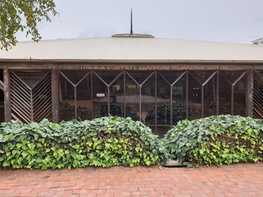
Photograph, Clare Gervasoni, Federation University SMB Campus Library, 23/04/2020
The E.J. Tippett Library is named after the late E.J. Tippett who was a long time President of the Ballarat School of Mines Council, and library advocate. In February 1985, the first sod for the new SMB Campus building was turned by the Minister for Planning and the Environment, the Hon. Evan Walker, M.P. The overall responsibility for the building rested with the Public Works Department in association with the SMB Campus architect, Ewan Jones & Associates and the builder, S. J. Weir Pty. Ltd. They put together the facility that is both functional and of a style that merges with the surrounding architecture. The new building was opened on 04 July 1986 by Governor of Victoria, His Excellency Dr Davis McCaughey.E.J. Tippett Library on the Ballarat School of Mines library.ballarat school of mines, smb campus library, e.j. tippett library -
 Ballarat Clarendon College
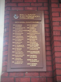
Honour board, Ballarat and Clarendon College School Captains
Honour boards instituted by the newly amalgamated Ballarat & Clarendon College in 1974 to honour the student/s elected as school captains. First board 1974 - 1999. Second board 2000 - 2011. In 2012 the school undertook a major project and created three new boards. One board honours Ballarat College Dux (1868 - 1973) and School Captains (1914 - 1973); another board honours Clarendon Presbyterian Ladies' College Dux and Head Prefect (1919 - 1973). These boards resemble the 1950 re-creation. A third board, replacing item 000084 was instituted in 2012 to honour Ballarat Clarendon College Dux and School Captains (1974 - ) . Two mahogany stained wood boards with two relief boards each and gold lettering. ballarat-and-clarendon-college, honour-board, school-captains, -
 Ballarat Clarendon College
Trophy
From 1884 College Cups were donated by the Old Collegians Association for the outstanding athlete amongst ‘present boys’ and ‘past boys’. It is obvious from written records and the inscriptions on the cups themselves that two cups were awarded to students – a Junior Cup and a Senior Cup. One cup was awarded to the outstanding old collegian athlete. John Mercer Walker (BD 23/02/1888) attended Ballarat College 1899 - 1904. Son of J T Walker 125 Dana St, Brother of Stanley, Harold J & Leslie, Uncle of John S & Lynette, John was Dux of the school in 1904. He was killed serving with the airforce in WW1. Large, wide silver rose bowl cup; double-handles; dark, polished wood standInscribed on face of bowl: OLD COLLEGIANS CUP / 1912 / Won by / J M WALKER Inscribed on rear of cup: Ballarat College crestjohn-mercer-walker, old-collegians-cup, ballarat-college, athletics -
Federation University Historical Collection
Award, Stokes, Peter Alexander's Junior Techncial School Athletics Medallion, 1958, 1958
Stokes was established in 1856 by a young English die-sinker named Thomas Stokes, who had arrived from England duringthe gold rush of that era. Disappointment in the fields led him to Melbourne where he setup business as a diesinker producing medals, tokens, buttons and silverware, a skill he acquired over five dedicated years of apprenticeship which he had completed in Birmingham, England. A merger with G.F Martin in 1867 saw the firm introduce electroplated nickel silver to Australia. The banking crisis of the 1890’s saw a split with Martin and the gradual joining of Thomas Stokes’ three sons, and by 1911 the company was called Thomas Stokes and Sons. A double sided medallion featuring a runner on one side and engraved information on verso.Engraved into the medallion J.T.S. Under 15 Athletics P. Alexander 1958ballarat junior technical school, athletics, numismatics -
Federation University Historical Collection
Award, Stokes, Peter Alexander's Junior Techncial School Basketball Medallion, 1960, 1958
Stokes was established in 1856 by a young English die-sinker named Thomas Stokes, who had arrived from England duringthe gold rush of that era. Disappointment in the fields led him to Melbourne where he setup business as a diesinker producing medals, tokens, buttons and silverware, a skill he acquired over five dedicated years of apprenticeship which he had completed in Birmingham, England. A merger with G.F Martin in 1867 saw the firm introduce electroplated nickel silver to Australia. The banking crisis of the 1890’s saw a split with Martin and the gradual joining of Thomas Stokes’ three sons, and by 1911 the company was called Thomas Stokes and Sons. A double sided medallion featuring a basketballer and the word 'basketball' on one side and engraved information on verso.Engraved into the medallion Ballarat Junior Technical School 1960 Basketball P. Alexander 1958ballarat junior technical school, athletics, numismatics -
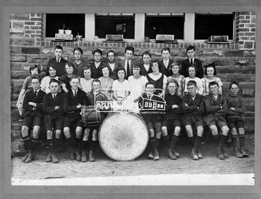 Eltham District Historical Society Inc
Photograph, State School No. 209. Dalton Street, Eltham, 1923
Back Row L-R: Garnet Burges, Keith Poulter, Jack McColl, Geoff Braithwaite, Pat Carrucan, Teddy (Alf) Harvey, Jack Carrucan, Jack Burgoyne Second Row L-R: Dorothy Butler, Dulcie Stone, Nell Leadbeater, Gwen Ryan, Gwen Butler, Maisie McColl, Mollie Russell, Phyllis West, Grace Braithwaite, Evie Bunker, Violet Fraser Front Row L-R: Jack Newton, Cyril Bowman, George Harrison, Fred Butterworth, Stan Ellis, Loftus Hancock, Harry Butherway, George Pitcher, Sid Castledine Cross Reference Photo No.(s): 641, 642, 672, 717This photo forms part of a collection of photographs gathered by the Shire of Eltham for their centenary project book,"Pioneers and Painters: 100 years of the Shire of Eltham" by Alan Marshall (1971). The collection of over 500 images is held in partnership between Eltham District Historical Society and Yarra Plenty Regional Library (Eltham Library) and is now formally known as the 'The Shire of Eltham Pioneers Photograph Collection.' It is significant in being the first community sourced collection representing the places and people of the Shire's first one hundred years.Digital image and 4 x 5 inch B&W Negsepp, shire of eltham pioneers photograph collection, eltham, dalton street, state school no. 209, cyril bowman, dorothy butler, dulcie stone, evie bunker, fred butterworth, garnet burges, geoff braithwaite, george harrison, george pitcher, grace braithwaite, gwen butler, gwen ryan, harry butherway, jack burgoyne, jack carrucan, jack mccoll, jack newton, keith poulter, loftus hancock, maisie mccoll, mollie russell, nell leadbeater, pat carrucan, phyllis west, sid castledine, stan ellis, teddy (alf) harvey, violet fraser -
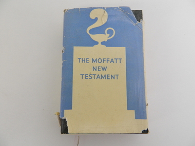 Kiewa Valley Historical Society
Bible, Bible Moffat, 1935
This Christian Bible by Professor James Moffatt from the United Free Church College in Glasglow Scotland was at a time when translated Christian bibles(Greek to English) were being review as to the accuracy of their translated words. This period was in the early 1900's specifically during and between the two major World Wars of 1914-18 and 1939-45 and also covering the Great Depression(1939). All these periods were ones of death, destruction and "loss of faith". Bibles which provided greater clarity of better times ahead flourished. This book offered its readers hope for the future (in terrible times). The regions that it covered were those who belonged to the Christian Faith. The significance of this bible to the Kiewa Valley is that it provides an insight of those Christians living in a semi remote rural region at the period in Australian history where forces outside of this area were placing hardships which were "foreign" to them, as a family and as a community. The major Christian religions within the Kiewa Valley were either of the Catholic or English Protestant teachings. These groups still remain the dominant ones well into the 2nd Millennium. Spiritual relief to overcome harsh rural setbacks is not just specific to the Australian rural sector but is also global. With the influx of migrant workers from the war torn European nations (after WWII) a broader coverage of Christian and other faiths developed. A "positive" saying, when crops failed and bush fires and river floods sprang up, rallied the faithful "with God's help" This hard covered bible consists of six pages of preamble including title, publishing details, printer and author's preface. The book has 388 pages of black print. Relevant reference lines are notated by numbers on the left side of the page. On the front dust cover is a cream silhouette against a light blue backdrop highlighting a smoking "Aladdin's" Arabic oil lamp on a cenotaph. The hard cover has a embossed emblem of a lantern with a plume of smoke rising from the spout. This is all encapsulated by a circle. The spine also has this emblem. On the dust jacket, front "THE MOFFATT NEW TESTAMENT", and the back cover has blue writing on a cream background. On the spine, at the top "JAMES MOFFATT" below this a white on blue silhouette of "Alalddin's lamp" below this is (in blue letters against a light blue background " THE NEW TESTAMENT A NEW TRANSLATION" On inside cover a signature "Clare Roper". The hard cover has marked in red print "THE NEW TESTAMENT ANEW TRANSLATION MOFFAT" christian bible, prayer, new testament, religion, faith. -
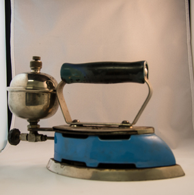 Kiewa Valley Historical Society
Iron Hand Kerosene, mid to late 1900s
The 1950's saw a revolution in small appliances for use in the average household. This hand held self heating(kerosene) iron was introduced as a time saving and more convenient iron for pressing clothes and other cloth fabrics. It replaced irons needing a separate fire source to heat the ironing plate. These irons continued to be in service, even when electricity was available in cities and larger rural towns (domestic electric steam irons were invented in 1938). This item was used before and during the electricity supplies available from the Kiewa Hydro Electricity Scheme. These irons remained in use within regional rural areas that had limited or unreliable electrical reticulation.In the 1950s and later the Kiewa Valley was still a relatively isolated region which was home to rural properties and small settlements. The availability of electricity and or the financial means to afford new types of electric hand irons ensured that older and sometimes less efficient ironing remained for an extended period covering the 1960s to 1970s. Kerosene products, such as this kerosene iron was a cheaper method for farm based domestic and other rural activities requiring a heat source. The use of kerosene as a heat/light source was able to be supplied in bulk and able to be used when floods severed vital roads into this region. The supply of electricity was in summer time subject to interruption from bush fire damaged wooden poles carrying the electrical cables. Self sufficiency by rural populations was the backbone of survival and the ability to store energy sources "on the farm" was a prerequisite of isolated regions, such as the Kiewa Valley, circa 1950s.This Coleman kerosene iron has a solid steel chrome plated(press) base with a painted (blue) wooden handle. The handle is stud fastened onto an oblong shaped rolled steel handle frame and screwed (two screws) onto the base plate. Both the heating plate and the top securing plate are shaped similar to a river boat. The main housing enclosing the heating element is enamel coated(blue in colour) steel and has a half hole for lighting the kerosene at the rear end. Behind the handle and protruding upwards is a stainless steel fully enclosed container (bowl shaped) for the main supply of kerosene to the burner or generator(enclosed within the main body of the iron. The bowl has an air valve and inlet for pressurised air intake (hand pump) On the bottom rear of the fuel bowl there is a screw regulated fuel pump. The fuel heated base plate provides the heat for this advertised "self heating iron(instant lighting). See KVHS 0347B- Instruction sheet; KVHS 0347C- Wrench; and KVHS 0347D Fuel can.Stamped on the base plate of the handle, front region "COLEMAN LAMP & STOVE CO." below this "WICHITA KAN" below this"TORONTO CAN". In the middle of the handle base and in larger print "COLEMAN Instant-Lite" At the rear location in large print "MODEL 4" in smaller print below "MADE IN U.S.A." below this "PAT#1718473"household appliances, alternative non electrical ironing appliances, domestic appliances, kerosene appliances -
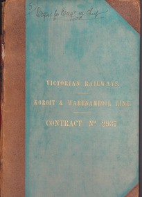 Warrnambool and District Historical Society Inc.
Document - Victorian Railways. Koroit & Warrnambool Line. Contract No. 2937, Circa 1888
The Victorian Railways began in 1854 and in the first 14 years up to 1868 had managed to complete about 250 miles of track. The next 60 years saw the system expand to nearly 3000 miles. By 1931 every town with a population over 500 had its own railway station. Early Victorian railway maps indicate that the extension from Colac to Warrnambool and then onwards to Koroit, occurred in the period of the 1880’s when the act known as the Octopus act saw a rapid expansion of lines. At the time there was much debate over where the expansion of the lines should take place, with one of the prime considerations for Warrnambool was the impact it would have on its port.The building of the railway to Warrnambool and onward to Koroit was a significant event for the town. Green cloth cover with tan suede corner points and spine. Title printed in gold on front cover. Title printed in gold on red on spine. 92 pages. The contract is printed and includes handwritten entries with specifications.Handwritten on front cover and inside front cover ” Copy for Engr in Chief” .On Page 2 transferred to Allan Reid * 24/1/88 Co Briscoe & Co Little Collins Street, Melbourne.warrnambool, railways, warrnambool to koroit railway, victorian railways contract no 2937 -
 Orbost & District Historical Society
purse
From the estate of Elsie Cooke who was the Orbost librarian for many years before 1940's. Elsie Cooke lived all her life in Gippsland,. She was born at Brodribb in 1895 and died in 1970, Elsie Cooke lived at Bruthen for a short time and, in 1937, moved to live with her aunt, Miss Jean Munro. Miss Cooke was Librarian at the Mechanics Institute for many years. Kindness and consideration for other were Miss Cooke’s attributes and she endeared herself to all who knew her. She was a loyal member of the Presbyterian Church and a stalwart of the Ladies’ Guild, an energetic worker for the Municipal Auxiliary and a member of the Red Cross. (ref. Mary Gilbert) Elsie Cooke was a well-respected Orbost identity. This item is an example of a fashionable accessory used by women in the first half of the 20th century.Small black velvet lady's change purse. Metal clasp and black holding string. Velvet has floral design. Purse has two coins inside - 1938 threepence (3d) and 1918 sixpence (6d) purse personal-effects money-containers -
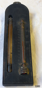 Flagstaff Hill Maritime Museum and Village
Thermometer, Early 20th Century
A Storm Glass and Thermometer such as this one would be used in predicting or forecasting the weather. Farmers used predictions they read from their Storm Glass to prepare for stormy weather or for choosing a good time for planting or harvesting their crops. This could mean to them the difference between a good year and a year without income. This design has been in use since the early 1800’s. According to Admiral Fitzroy (who studied the storm glass and wrote instructions on its use) the liquid in the glass changes composition and appearance according to the direction of the air moving around it. He advised the user to disturb the contents once or twice a year by tipping it upside down and shaking it gently. Item is a good example of a barometer/thermometer that would have been in most homes and farms from the late 19th century and early 20th century. This item would have been massed produced at the time therefore easily available and quite cheap to purchase making this particular item not very significant as not associated with a historic person or property or with a known manufacturer or date.Storm Glass and Thermometer, commonly called a 'Cottage Barometer', mounted on a rectangular dark rectangle of wood, top corners rounded. The Storm Glass (or weather glass, or chemical weather glass) is suspended in a long oval shaped hole in the wood on left side, held in place at top and at bottom with 2 metal bands secured by nails. The glass of this gauge is hand blown, sealed at the top with another layer of glass. The watery fluid in the storm glass is opaque brownish colour with dark particles floating in it. (Storm glasses were usually filled with a variation of a mix of camphor, distilled water, ethyl alcohol and silver nitrate.) The alcohol thermometer is mounted on the right side of the wood, bulb resting in a hollow, attached at top and near base by 2 thin metal strips, with clover-leaf shaped ends, nailed into place. Over the bulb is nailed a metal guard with 3 ventilation slits cut into it. On left of thermometer is a scale, stamped into wood, 30 below zero to 130 above zero, in 2 degree intervals. A border of 2 thin parallel lines, with remnants of light coloured paint, is around the block of wood. On the reverse side, a metal plate is nailed to the top with a mounting hole in it. Impressed sideways along edge of barometer is "STORMY" "CHANGE" "FAIR". Across the top of the thermometer is a fleur de leis in the wood, and above this it is stamped "FAHRENHEIT". On right of the thermometer, stamped into the wood, is "BLOOD/HEAT", "SUMR/HEAT", "TEMPE/RATE", "FREEZ/ING". On the back of the wood, at the base, are remnants of a white sticker with "...111.73". Carved into the wood is "HOLLAND / AV". flagstaff hill, warrnambool, shipwrecked coast, flagstaff hill maritime museum, maritime museum, shipwreck coast, flagstaff hill maritime village, great ocean road, barometer, cottage barometer, storm glass, thermometer, chemical weather glass -
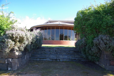 Federation University Historical Collection
Photograph, Federation University Australia E.J. Tippett Library, 2013, 23/09/2013
The E.J. Tippett Library is named after the late E.J. Tippett who was a long time President of the Ballarat School of Mines Council, and library advocate. In February 1985, the first sod for the new SMB Campus building was turned by the Minister for Planning and the Environment, the Hon. Evan Walker, M.P. The overall responsibility for the building rested with the Public Works Department in association with the SMB Campus architect, Ewan Jones & Associates and the builder, S. J. Weir Pty. Ltd. They put together the facility that is both functional and of a style that merges with the surrounding architecture. The new building was opened on 04 July 1986 by Governor of Victoria, His Excellency Dr Davis McCaughey.Two colour photographs showing the exterior of the E.J. Tippett Library at Federation University Australia SMB Campus, and two taken from inside the library looking over Ballarat East.e.j. tippett library, tippett library, smb library, tippett, e.j. tippett, ewan jones & associates -
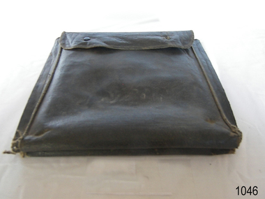 Flagstaff Hill Maritime Museum and Village
Functional object - Courier Bag, Late 19th to mid 20th centuries
The black imitation leather or leatherette bag or pouch could have been used by a courier to transfer documents, letters or business records between offices or from business to customer. Imitation leather was invented in the late 1800s and improved as time went on. The manufacture of synthetic leather began around the 1930s. The courier bag may have been used for a s similar purpose as the cash bags in our collection. Those cash bags transported money between the railway stations of Grassdale and Merino in Victoria's western district in the late 19th and early-to-mid 20th centuries. Perhaps the bag was used by the coastal trading vessels that operated in southwest Victoria until around the 1940s.This courier bag is an example of the connections made between people in the remote areas of Victoria. It could have been used by the railway system or the coastal trader vessels that shipped people, goods, documents and cash between the districts in western Victoria.Courier bag; black imitation leather pouch, square with wide seams and a flap with sttud closure at the top. Made by British Products Pty Ltd. "British Products Pty Ltd"warrnambool, shipwreck coast, flagstaff hill, flagstaff hill maritime museum, flagstaff hill maritime village, bag, pouch, imitation leather, artificial leather, faux leather, synthetic leather, british products pty ltd, document pouch, courier bag, western district, western victoria, 19th century, 20th century, railway, rural business, rural trade, coastal trader, southwest victoria -
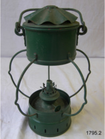 Flagstaff Hill Maritime Museum and Village
Functional object - Lamp, Kosmos Brenner, First half of the 20th century
The Kosmos burner is probably the most popular burner used in European lamps. A patent for the design was first lodged in the UK in 1865 by Wild & Wessel from Berlin. In 1875 they began using the trade mark 'Kosmos' on winder knobs. The mark was taken over in 1899 by Brokelman, Jager & Co. who changed it to 'Kosmos Brenner', (literally 'Kosmos burner'), they continued to manufacture right up to the 1970's when the factory closed and most tooling was destroyed. A very popular burner in Germany and still manufactured today in France it has been used in all sizes of lamps from small hand lamps up to large table and hanging lamps.The subject item at this time cannot be associated with an historical event, person or place, provenance is unknown, item is believed to have been produced in the first half of the 20th century. Many different lamp manufactures used Kosmos Burners in their lamps up until the 1970s, therefore exact provenance and age is difficult to determine.Lamp, copper, handle on top and one beneath attached to a reservoir made of copper. No glass and painted green.Marked "Kosmos Brenner" to winder flagstaff hill, warrnambool, flagstaff-hill-maritime-museum, maritime-museum, shipwreck-coast, flagstaff-hill-maritime-village, lamp, kosmos burner, kerosene lamp, lighting -
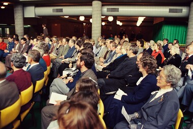 Federation University Historical Collection
Photograph, Opening of the E.J. Tippett Library at the Ballarat School of Mines, 1986, 04/07/1986
The E.J. Tippett Library is named after the late E.J. Tippett who was a long time President of the Ballarat School of Mines Council, and library advocate. In February 1985, the first sod for the new SMB Campus building was turned by the Minister for Planning and the Environment, the Hon. Evan Walker, M.P. The overall responsibility for the building rested with the Public Works Department in association with the SMB Campus architect, Ewan Jones & Associates and the builder, S. J. Weir Pty. Ltd. They put together the facility that is both functional and of a style that merges with the surrounding architecture. The new building was opened on 04 July 1986 by Governor of Victoria, His Excellency Dr Davis McCaughey.Photographs of the opening ceremony at the E.J. Tippett Library. e.j. tippett library, library, e.j. tippett, library catalogue cards, ewan jones and associates, smb library, ballarat school of mines -
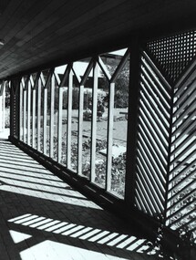 Federation University Historical Collection
Photograph - Photograph - Black and White, View from E.J. Tippett Library
The E.J. Tippett Library is named after the late E.J. Tippett who was a long time President of the Ballarat School of Mines Council, and library advocate. In February 1985, the first sod for the new SMB Campus building was turned by the Minister for Planning and the Environment, the Hon. Evan Walker, M.P. The overall responsibility for the building rested with the Public Works Department in association with the SMB Campus architect, Ewan Jones & Associates and the builder, S. J. Weir Pty. Ltd. They put together the facility that is both functional and of a style that merges with the surrounding architecture. The new building was opened on 04 July 1986 by Governor of Victoria, His Excellency Dr Davis McCaughey.Black and white photo taken from outside the Tippett Building, showing the wood pattern at the entranceballarat school of mines and industries, tippett building, ballarat school of mines, library, buildings, ewan jones and associates, e.j. tippett library, smb library