Showing 6436 items matching "housing"
-
 Eltham District Historical Society Inc
Photograph, Artichokes growing at Bell Street, Eltham, c.1990s
Fabbro's farm and house, Bell Street, Eltham, c.1990s. A crop of artichokes were planted on the farm at this time. The site of the Fabbro farm (Diamond Creek side land) is now called Barrack Bushlands. It is doubtful that Fabbro's farm holding was ever called Barrak Park, This title is fairly recent after the Shire of Eltham purchased the land, including the last section in 1993/94. About this time the area on the west side of Falkiner Street was purchased by a private developer and developed as housing. The area in Bell Street opposite the Eltham High School was purchased by the State Government is recent years and is called Fabbro Fields. The Fabbro Family operated their farm in Bell Street, Eltham. 1 colour photograph printed with white borderfabbro's farm, bell street, eltham, artichokes, barak farm -
 Eltham District Historical Society Inc
Photograph, Maurice Fabbro with artichokes growing at Bell Street, Eltham, c.1990s. Maurie is in his 70s
Fabbro's farm and house, Bell Street, Eltham, c.1990s. A crop of artichokes were planted on the farm at this time. The site of the Fabbro farm (Diamond Creek side land) is now called Barrack Bushlands. It is doubtful that Fabbro's farm holding was ever called Barrak Park, This title is fairly recent after the Shire of Eltham purchased the land, including the last section in 1993/94. About this time the area on the west side of Falkiner Street was purchased by a private developer and developed as housing. The area in Bell Street opposite the Eltham High School was purchased by the State Government is recent years and is called Fabbro Fields. The Fabbro Family operated their farm in Bell Street, Eltham. 1 colour photograph printed with white borderfabbro's farm, bell street, eltham, artichokes, barak farm, maurice fabbro -
 City of Moorabbin Historical Society (Operating the Box Cottage Museum)
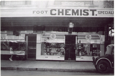
Photograph, Black & White, Mr Moore's 1st Chemist Shop Centre Road, Bentleigh c1930, c1930
Early settlers in the Parish of Moorabbin, County of Bourke, established market gardens and farms in the area of Henry Dendy's Special Survey 1841 Brighton. Small communities grew near Churches & Schools and shops and businesses were established. Following the opening of the Railway line from Caulfield to Mordialloc 1881 the shops and business moved from the Tucker Road /Centre Road ( East Brighton ) East Bentleigh area to be close to the transport. Shops, businesses and housing developed along Centre Road between Thomas Street and Jasper Road. Mr Arthur Moore established his 1st shop in 395 Centre Road c1930 and later moved along the road to a site next to Coles Variety Store.Following the opening of the Railway line from Caulfield to Mordialloc 1881 the shops and business moved from the Tucker Road /Centre Road East Bentleigh area to be close to the transport. Shops, businesses and housing developed along Centre Road between Thomas Street and Jasper Road. Mr Moore established his 1st shop in 395 Centre Road c1930 and later moved along the road to a site next to Coles Variety Store.Black & White photograph of Mr Arthur Moore's 1st Chemist Shop, 384 Centre Road Bentleigh c 1930 back Handwritten information unsignedbentleigh shopping centre c1930, east brighton, railway line caulfield -mordialloc 1881, chemists, pharmacy, moore's moorabbin shire, smith j l, smith mary ann, stanley helen, smith vic, smith harry redvers, chaff cutter, horse drawn carts, toll gates brighton, motor cars 1900, steam engines, early settlers, bentleigh, mckinnon, parish of moorabbin, city of moorabbin, county of bourke, moorabbin roads board, shire of moorabbin, henry dendy's special survey 1841, were j.b., bent thomas, o'shannassy john, king richard, charman stephen, highett william, ormond francis, maynard dennis, market gardeners, vineyards, orchards -
 Surrey Hills Historical Society Collection
Photograph, Streetscape near the corner of Victoria Crescent and Hotham Street, Surrey Hills
Prior to subdivision for housing this area was paddocks used for grazing of cattle and used as part of the course in the early days of the Surrey Hills Golf Club. Reproduced by permission of Mr John Arnold from his book: "The Riversdale Golf Club - a history, 1892-1977." Copyright to book: Riversdale Golf Club. Surrey Hills Golf Club operated from 1892-1908 then moved and became Riversdale Golf Club. The game was played across paddocks from Trafalgar Street, Mont Albert to Whitehorse Road and down Victoria Crescent to where Box Hill TAFE is now located in Elgar Road. There were problems with cows eating the tee flags! The clubhouse still exists as 30 Trafalgar Street.Black and white photo taken from the centre of a bitumen road which is flanked by bluestone guttering. Nature strips, drive cross-overs and house fences are shown. Trees on the RHS nature strip are pollarded to avoid overhead power and telephone lines. There houses in the background."Bottom: The same view today taken from the intersection of Victoria Crescent and Hotham Street, Surrey Hills."surrey hills golf club, hotham street, victoria crescent, riversdale golf club, surrey hills, john arnold -
 Harcourt Valley Heritage & Tourist Centre
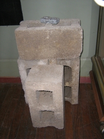
concrete blocks, 1914
Charles Seelenmeyer conducted Concrete Utilities Limited (Harcourt Cement Pipe Factory). Operated in Harcourt circa 1914 to 1930 in premises situated opposite the ANA Hall on what is now the road reserve. Principal raw material was sand from the adjacent waterway ( Barkers Creek.) Principal output was concrete drainage tiles for use in district orchards but concrete blocks were also produced for construction of homes and commercial buildings. At a time of rapid expansion of the orchards this industry provided a vital piece of orchard infrastructure, mostly buried and not now visible but nevertheless a very important feature of the valley’s horticultural industry.. Homes built with these concrete blocks are a distinct part of Harcourt’s housing stock. Harcourt Cement Pipe Co was an example of local initiative to solve a local problem using local materials. A collection of 4 concrete building blocks -
 Melbourne Legacy
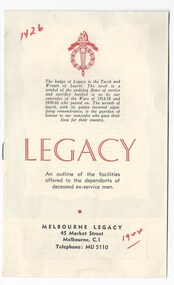
Booklet, Legacy. An outline of the facilities offered to the dependants of deceased ex-servicemen. (H26), 1944, 1953, 1959, 1961
A brochure explaining Legacy's work and the facilities they provide. It is aimed at the widows to inform them of what is available to them and it outlines the times for classes for the children. The earliest copy in 1944 included the charter of Legacy and headings in red printing. 'Melbourne Legacy offers friendship and help to the dependants of our departed comrades.' Headings included: Help and advice to mothers or guardians; Mothers' Club; Senior Widows' Club; Housing and repairs; Legal advice; Medical, dental and optical care; Education, Employment, Camps and holidays, Christmas party, Residences, Junior Legacy groups. The notation H26 in red pen shows that it was part of the archive project that was trying to capture the history of Legacy. See other editions at 01447.A record of how Legacy portrayed itself to the widows and children in 1944,1959 and 1961/8. Black and white brochure made of white paper, folded into a 8 page booklet. 01498.1 1944 (handwritten in red pen) 01498.2 April 1953 01498.3 April 1959 01498.4 October 1959 01498.5 June 1961 with markings to edit it for reprinting in July 1968Handwritten 'H26' and '1944' in red pen. 01498.5 has edits in blue pen to revise the content for republication.legacy promotion, history -
 Ballarat Tramway Museum
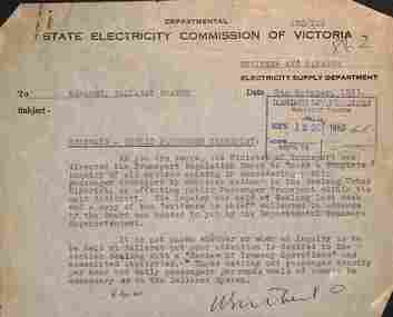
Letter - Memo, State Electricity Commission of Victoria (SECV), "Tramways - Public Passenger Transport", 10/1953
Set two SEC memos that were clipped together with item 9824. 1 - titled "Tramways - Extensions" from the Engineer Manager of Electricity supply department (Melbourne) to the Ballarat manager, dated 7-10-1953 - asking for survey information about housing numbers along each route and the possibility of extending the Victoria St and Mt Pleasant routes. 2 - titled "Tramways -Public Passenger transport" - from the Engineer Manager of Electricity supply department (Melbourne) to the Ballarat manager, dated 12-10-1953 - regarding the recent inquiry in Geelong and that data regarding passenger density per hour and passengers per route would be desirable. See item 9806 for this type of materials. Demonstrates SEC Head office correspondence with the Ballarat Branch office re tramways.Set of two typed memos on SECV letterhead.tramways, trams, ballarat, new tramways, passenger services, statistics, enquiry -
 Merbein District Historical Society
Journal - Quarterly, The Newsletter - The Quarterly Journal of MDHS - No. 2, Dec. 2000
millewa school sites, merbein higher elementary school, christmas, merbein carnival, lappin and blass, big lizzie , birdwoodton, bank, school days, housing, ivy berick, william john (jack) lemon, our lady's school, mdhs -
 Warrnambool and District Historical Society Inc.
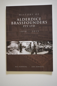
Book - History of Alderdice Brassfounders Warrnambool, Bill Downing and Jane Downing, History of Alderdice Brassfounders Pty Ltd 1898-2015, 2016
History of Warrnambool Factory - Alderdice Brassfounders Pty LtdThis is a book of 108 pages. It has a brown cover with white printing and a black and white photograph on the front cover and printing and seven black and white photographs on the back cover. The pages contain printed material and black and white photographs. non-fictionHistory of Warrnambool Factory - Alderdice Brassfounders Pty Ltdalderdice brassfounders pty ltd, agriculture in warrnambool district, william & charles downing -
 Warrnambool and District Historical Society Inc.
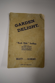
Booklet, Garden Delight, 1932
This booklet is a 1932 catalogue of the Floral Farm in Warrnambool. It was established by Charles Allen Jukes who had first opened a plant nursery at Cudgee on the banks of the Cudgee Creek. Early in the 20th century the nursery, the Floral Farm, was re-located to East Warrnambool with the boundary of the property extending along Raglan Parade, Flaxman and Bostock Streets. . A very high paling fence, topped with vertical slats was erected around the property. The Floral Farm continued for some time (with Charles Allen Jukes dying in 1934) and the nursery land was sub-divided for housing. Charles Allen Jukes’ parents, Alfred and Margaret came to Warrnambool in 1856, with Alfred setting up a law business and at one time being the honorary Town Clerk of Warrnambool. This booklet is of historical interest as it is a catalogue of the plants and seedlings available in the early 1930s from the Jukes Floral Farm in East Warrnambool. The parents of the Floral Farm business, Alfred and Margaret Jukes, were pioneer settlers in Warrnambool.This is a booklet of 40 pages. The cover has blue printing and was once white or buff-coloured but is now much stained. The pages contain information on plants and seedlings and have many black and white photographs. The booklet is dog-eared and crumpled.jukes family, warrnambool, floral farm nursery, warrnambool -
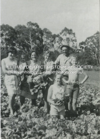
 Eltham District Historical Society Inc
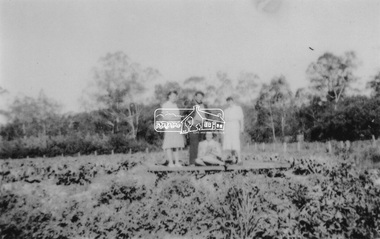
Photograph, At Bell Street, Eltham; from left: Helen Skipper, Matcham Skipper, Sonia Skipper and possibly Myra Skipper
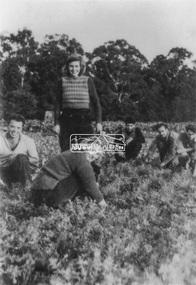
At Bell Street, Fabbro Farm, Eltham; From left: Helen Skipper, Matcham Skipper, Sonia Skipper and possibly Myra Skipper, standing in the middle of a vegetable crop. The site of the Fabbro farm (Diamond Creek side land) is now called Barrack Bushlands. It is doubtful that Fabbro's farm holding was ever called Barrak Park, This title is fairly recent after the Shire of Eltham purchased the land, including the last section in 1993/94. About this time the area on the west side of Falkiner Street was purchased by a private developer and developed as housing. The area in Bell Street opposite the Eltham High School was purchased by the State Government is recent years and is called Fabbro Fields. The Fabbro Family operated their farm in Bell Street, Eltham. 1 black and white photographfabbro's farm, bell street, eltham, farming, helen skipper, vegetables, matchcam skipper, myra skipper, sonia skipper -
 City of Moorabbin Historical Society (Operating the Box Cottage Museum)
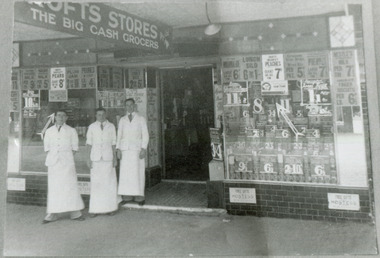
Photograph - Black & White, Crofts Grocery 395 Centre Rd Bentleigh c1937, c1937
After the extension of the Railway line from Caulfield to Mordialloc 1880's the shopping centre moved from the Tucker Rd end to around the East Brighton (Bentleigh) Station area of Centre Road. A variety of shops, forges, estate agents, Coles' and Fossey's variety stores, a Hoyts picture theatre, butchers, traded in Centre Rd. Crofts was one many grocery stores along the strip. Crofts Stores was established by Archibald Crofts (1875-1942) as a single grocery store in South Melbourne. It eventually expanded to include 137 branches throughout Victoria, trading as Crofts Stores. The Lees family had established a Seedling Nursery in Thomas St that has continued until the land sold 2018 for housing development.Crofts Grocery Store was one of the shops in the Centre Road Bentleigh shopping strip that were established after the arrival of the train line 1881Black & White photograph of 3 men outside Crofts Grocery Store 395 Centre Rd Bentleigh c 1937 Mr Jack Lees is centre.Handwritten informationcrofts grocery store bentleigh, lees jack, mordialloc railway line, centre road bentleigh, smith j l, smith mary ann, stanley helen, smith vic, smith harry redvers, chaff cutter, horse drawn carts, toll gates brighton, motor cars 1900, steam engines, early settlers, bentleigh, parish of moorabbin, city of moorabbin, county of bourke, moorabbin roads board, shire of moorabbin, henry dendy's special survey 1841, were j.b., bent thomas, o'shannassy john, king richard, charman stephen, highett william, ormond francis, maynard dennis, market gardeners, vineyards -
 Melton City Libraries
Photograph, Western Highway, 1983
Construction of service road in front of the former Ann Dowling (Miers) 1866 Crown Grant, Title dated October 1870. She married Henri Miers in 1867.Their house was located on the site near the Myers Gully part of Ryans Creek. Built in 1867 and later named “Burnbank” by Martha Myers after the Street in Ballarat were she lived before arriving in Melton in 1907. She married Frederick Myers in 1908. He died in 1963, and Martha moved to a new home at 5 McKenzie Street Melton in 1968. Attempts made by the family to retain the historic cottage were unsuccessful. A demolition order imposed by the Housing Commission and it was pulled down by the family. It was the home of the family and stood for over 100 years.East of Reserve Road towards Ferris Roadlandscapes of significance, misc. -
 Eltham District Historical Society Inc
Photograph, Antonio and Angelina Casonato and family
Antonio and Angelina Casonato with their four children and a baby cousin taken with lettuces growing on the river flat at Bell Street, Fabbro Farm (Fabbro Fields) in front of Eltham High School in the late 1960s. The site of the Fabbro farm (Diamond Creek side land) is now made up of Fabbro Fileds and Barrack Bushlands. This title is fairly recent after the Shire of Eltham purchased the land, including the last section in 1993/94. About this time the area on the west side of Falkiner Street was purchased by a private developer and developed as housing. The area in Bell Street opposite the Eltham High School was purchased by the State Government is recent years and is called Fabbro Fields. The Fabbro Family operated their farm in Bell Street, Eltham. 1 black and white photograph reproduction print (low quality)fabbro's farm, bell street, eltham, farming, vegetables, angelina casonato, antonio casonato, fabbro family, fabbro farm, fabbro fields -
 St Kilda Historical Society
Photograph, St Kilda Municipal Depot, Inkerman Street - images collection, 1979
Prior to its demolition in 1979, the St Kilda Municipal Depot occupied a 1.2 hectare site at 33 Inkerman Street St Kilda. The land was initially purchased by the Council in 1867 as a site for a permanent market, which ceased to operate in about 1882. In October 1923, the Council discontinued the practice of disposing garbage by burial in tips when it opened a garbage incinerator at the Depot. After thirty years this incinerator had become both obsolete and objectionable to health and was replaced in March 1953 by American-designed Monohearth Garbage Destructor Units. According to the Council, these Destructor Units were the only ones of their kind in Australia and they removed all the objectionable features of garbage disposal (particularly for the employees). They were expected to serve St. Kilda's requirements for the next 80-100 years. In 1957 the Council said that the Destructor Units had 'enabled substantial economies to be effected in the annual costs and have proved a very successful venture. The Council now destroys the garbage from the City of Brighton, which pays for the privilege, and it is anticipated that other Municipalities will also take advantage of ihe benefits of this modern and, in Australia.' See 'City of St Kilda 1857-1957 A Brief Outline of Progress and Development' [82] In 1994, as a result of the local government amalgamation process combining the former Cities of Port Melbourne, South Melbourne and St.Kilda, the new City of Port Phillip owned three municipal depots. The St. Kilda municipal depot site became surplus to requirements and, in 1996, the City of Port Phillip resolved to use the site for a community housing project under the City of Port Phillip Housing Program. Colour photographCouncil Yards before demolition 1979st kilda, st kilda municipal depot, inkerman street, council depot, destructor -
 Kiewa Valley Historical Society
Photograph - Mt Beauty timber Industries, 1960's (estimate only)
Hume and Hovell discovered the area in 1824 and by the end of the 19th century the valley was transformed by logging, dairy and beef cattle properties and tobacco farms. Timber was required for construction of McKay Creek Power Station which began construction in 1951 and also the camps and houses for the workers and their families. There was a need for housing and infrastructure for an increasing population of workers for the hydro-electric scheme as there was a general shortage of this commodity. A timber mill was started in Tawonga by Mates, of Albury, in 1945, and electricity became available in 1946 the S.E.C. bought the mill, and enlarged it. In 1960 it was purchase by a local family. They also started a timber mill in Mt Beauty and worked both until 1980 when they closed the Tawonga mill and enlarged the mill called Mt. Beauty Timbers Pty Ltd which employed approximately 50 people. A pictorial record of the development of the Mt Beauty community and the local timber industry.Colour photograph of aerial view of Mt Beauty Timber Mills and surrounding area including pondage and part of airfield. Photo taken in 1960’s (estimate only)Handwritten in ink on back of photograph in very faint writing – Recent photo of Mt Beauty Timber Industries Mt Beauty Operationsmt beauty timber industry, timber industry, timber mill, secv -
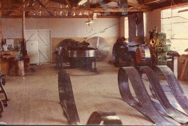 Kiewa Valley Historical Society
Photograph - Mount Beauty Timber Industries, 1960's (estimate only)
Hume and Hovell discovered the area in 1824 and by the end of the 19th century the valley was transformed by logging, dairy and beef cattle properties and tobacco farms. Timber was required for construction of McKay Creek Power Station which began construction in 1951 and also the camps and houses for the workers and their families. There was a need for housing and infrastructure for an increasing population of workers for the hydro-electric scheme as there was a general shortage of this commodity. A timber mill was started in Tawonga by Mates, of Albury, in 1945, and electricity became available in 1946 the S.E.C. bought the mill, and enlarged it. In 1960 it was purchase by a local family. They also started a timber mill in Mt Beauty and worked both until 1980 when they closed the Tawonga mill and enlarged the mill called Mt. Beauty Timbers Pty Ltd which employed approximately 50 people. A pictorial record of the development of the local timber industry in the Kiewa Valley showing equipment used in timber milling.Colour photograph of Mt Beauty Timber Industries Mill. Photo taken inside the workshop showing saw blades and equipmentmt beauty, mt beauty timber industry, timber mill -
 Warrnambool and District Historical Society Inc.
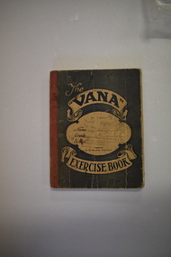
Tradesman’s Work Diary, Book, 1940s
This exercise book contains details on the work carried out by A.Greed, a tradesman undertaking small carpentry and repair jobs in the Warrnambool region. The works completed date from 17 April 1945 to 11 October 1949. Mr Greed apparently worked mostly for the Public Works Department and had contracts for schools including Ecklin South, Panmure, Cudgee, Dennington, Mailors Flat, Grasmere, and Warrnambool Technical School and for other public buildings including the Warrnambool Court House, the Police Station and Housing Commission buildings. Other contracts included ones for the Framlingham Aboriginal Reserve, Callaghan’s Garage, the Caledonian Hotel, the Methodist Croquet Club and many private home owners. Details on the identity of ‘A. Greed’ are not known as there are several possibilities for the 1940s era. One clue is that an ‘E. Greed’ was also an employee.This exercise book is of some interest as an example of a tradesman’s handwritten details of his work as a carpenter and repair man in the 1940s in the Warrnambool area. There are many local names and businesses of interest mentioned in the exercise book. This is an exercise book with a grey cover with red binding. The dark blue printing on the front cover is enclosed in scroll patterns and the back cover has dark blue printing The cover is creased and has some ink splotches. The front cover has been stamped but the printing is now mostly illegible. The pages contain handwritten work and accounting information in black and blue ink. Some pages have been overwritten in red and black ink and pencil and there is one loose sheet.The Vana Exercise Booka.greed,, warrnambool tradesman, history of warrnambool -
 Warrnambool and District Historical Society Inc.
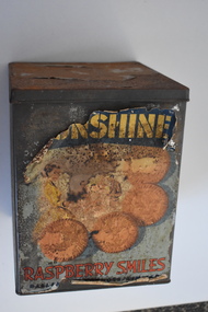
Biscuit Tin, Ballarat Products Limited (Sunshine Biscuit Co.), Mid 20th century
This tin came from the Sunshine Biscuit Factory in Ballarat. James Long established a confectionery business in Ballarat in 1854 and in 1921 it was known as the Sunshine Biscuit Company. In 1923 the factory was destroyed by fire and rebuilt. During World War Two 80% of the factory products went to the armed services. In 1947 the company was known as Ballarat Products Ltd and in 1962 it was called Sunshine Biscuits Ltd. In 1977 the factory was used to produce dry pet food (Friskies). The building was closed in 1991 and the site developed to include a supermarket, shops and housing. Up till about the late 1950s biscuits were mostly not packaged but sold loose by the pound in grocery stores from tins such as this. Broken biscuits were also sold at a cheaper price. Some biscuits were also sold at that time in smaller tins. This tin is of interest as an example of the tins from which biscuits were sold in the first half of the 20th century. It will be useful for display.This is a rectangular-shaped biscuit tin which is much rusted. The tin has a multi-coloured paper label that has been pasted around the sides. Much of this label has been torn away. The label shows images of biscuits. There is printing on the label and on the bottom of the tin. ‘Sunshine Raspberry Smiles’ ‘Ballarat Products Ltd.’ ‘This tin is not sold with the contents thereof but remains the property of Sunshine Biscuit Co Ballarat’ ‘Made in Australia 054’ sunshine biscuit factory, ballarat, history of warrnambool -
 Greensborough Historical Society
Photograph, Main Road bridge looking to township of Greensborough, 1929c
View of Main Street Greensborough from Partington's Hill including Plenty River bridge and Marble Hall on corner of Carter Street (now Para Road) and Main Street. This view of Greensborough Park shows the old pan toilets, the hawthorn fence line and the rather undeveloped roadside area of the park. Looking up Main Street we see the old Chapman house at the corner of Poulter Avenue and some newer houses below this. The stone river bridge appears to be only a single lane wide and the road approaching the bridge is unsealed. The rail bridge shows evidence of soot from steam trains and at the extreme left of picture the two concrete buildings indicate the line had been electrified. This occurred in 1923. Sparse housing is seen in the Flintoff Street and Grimshaw Street area.Part of a collection of photographic enlargements of views of Greensborough in the early 1900s.Black and white enlargement of photographic imagemain street greensborough, marble hall, greensborough railway, chapman house, greensborough park, poulter avenue greensborough, carter street, para road -
 Eltham District Historical Society Inc
Photograph, At Bell Street; from left: Maurie Fabbro, Myra Skipper, Unknown, Arthur Munday, Ian Robertson. Helen Comprione in front
At Bell Street, Fabbro Farm, Eltham; from left: Maurie Fabbro, Myra Skipper, Unknown, Arthur Munday, Ian Robertson. Helen Comprione in front - probably helping to pick a crop. The site of the Fabbro farm (Diamond Creek side land) is now called Barrack Bushlands. It is doubtful that Fabbro's farm holding was ever called Barrak Park, This title is fairly recent after the Shire of Eltham purchased the land, including the last section in 1993/94. About this time the area on the west side of Falkiner Street was purchased by a private developer and developed as housing. The area in Bell Street opposite the Eltham High School was purchased by the State Government is recent years and is called Fabbro Fields. The Fabbro Family operated their farm in Bell Street, Eltham. 1 black and white photographfabbro's farm, guido fabbro, bell street, arhur munday, eltham, helen comprione, ian robertson, maurice fabbro, myra skipper, picking, farming -
 City of Moorabbin Historical Society (Operating the Box Cottage Museum)
Photograph, Black & White, Methodist Children's Home Cheltenham Boys & Briquettes 1935, 1935
Boys from the Methodist Children's Home Cheltenham collecting Briquettes from the shed. Briquettes, made from Brown coal, were an economical source of heating for the Home The Methodist Children's Home in Cheltenham was founded c1880 to provide housing for neglected children from the inner city. The Founders aimed to provide regular nourishment, a stable environment and integrate the children into the local community thereby improving their education and lives. ( see 00561) 1950's saw a new direction for the support of children and families in poor and difficult situations . The new Burwood Homes Facility opened in 1951 and children were transferred from Cheltenham in 1952. The land was sold to the St John of God, Catholic Order in1953 who maintained an orphanage until Myer Pty Ltd bought the site in 1967 and constructed the Southland Shopping Centrec1892-1953 The Methodist Children's Home Cheltenham was founded to provide safe accommodation and education for neglected children from the inner city slums. Black & White photograph of some boys in the Briquette Shed at Methodist Children's Home Cheltenham 1935Back Handwritten informationmethodist children's home cheltenham 1892-1953, briquettes, heating, yallourn brown coal mine, city of moorabbin, county of bourke, moorabbin roads board, parish of moorabbin, shire of moorabbin, henry dendy's special survey 1841, were j.b.; bent thomas, o'shannassy john, king richard, charman stephen, highett william, ormond francis, maynard dennis, cheltenham state school no.84, methodist chapel cheltenham, methodist school cheltenham, beaumaris west state school, meeres frederick, meeres walter, education, early settlers -
 St Kilda Historical Society
Ephemera - Ticket, Picnic to Park Orchards, 1936
Ticket to picnic at Park Orchards on 21 December 1936, organised by the St Kilda Unemployed Organisation with the support of the St Kilda City Council, Mayor (Cr Alfred Levy), Archie Michaelis MLA, and 'other well-known gentlemen'. The ticket appears to have been perforated to allow vouchers, printed on the back (for bus, dinner, toys, stockings, ice cream and tea) to be separated and used. Park Orchards is a residential suburb 23km north east of Melbourne that was created in 1925 on land used for orchards when timber merchants Australis Sharp and John Taylor launched the Park Orchards Country Club estate. Buyers were not attracted to the estate, and for many years all that existed were a clubhouse and various sporting facilities. It gained popularity when demand for housing surged in the 1950s.Grey/green coloured card, printed in blue on both sides and with 5 evenly spaced lines of perforations across the width.st kilda unemployed organisation, st kilda council -
 Wangaratta RSL Sub Branch
Badge
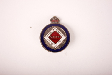
The Sailors and Soldiers Fathers' Association was established in the First World War and appears to have had branches in most states. The group was active (and often outspoken), involving themselves with hospital visits, repatriation issues, employment of returned servicemen and the establishment of returned servicemen’s rights relating to principles such as pensions and housing. There appears to be a close co-operation between this group and the Returned Sailors and Soldiers Imperial League of Australia in forming a group with strong lobbying abilities. Similarly, they were active in raising funds to build Memorials after the war. The Association remained active after the First World War in pursuing returned soldiers’ rights. They appear under a slightly different name during the Second World War (Sailors, Soldiers and Airmen’s Fathers' Association) but their goals were identical........The Sailors and Soldiers Fathers' Association, established during the First World War, was active in fundraising, establishing memorials and advocacy for issues such as the repatriation and employment of returned servicemen. The group worked closely with the Returned Sailors and Soldiers Imperial League of Australia, now known as the RSL.Round bronze and enamel badge badge with blue circular border enclosing a white and red diamond. Crown on top. In white border: "Sailors & soldiers Assoc.n of Vict." In red diamond: "Fathers" On back: "167 / Stokes Melb."badge, sailors and soldiers association of victoria, sailors and soldiers fathers' association -
 Melbourne Legacy
Document, The training of new Legatees. 26 May 1954 (H20), 1954
In the report on the work of Legacy in 1953 (see item 01491) it was mentioned that the education of Legatees was seen as something that needed to be addressed and a formal induction process with proper training would be necessary. A two page report was included as attachment 'C'. This is the report. It mentions the Board of Management decided to inaugurate a course of classes, over six Monday evenings. The topics covered: 1) The structure of Legacy and the nature of contact work. 2) Welfare Committee and Welfare assistance available from statutory sources. 3) Education and Employment Committee 4) Residences, Housing and Accommodation, Camp and Holidays Committees. 5) The Medical, Dental, Boys' and Girls' Group Committees. 6) Personnel and Comradeship. The notation H20 in red pen shows that it was part of the archive project that was trying to capture the history of Legacy. A report covering the need to train Legatees and how it was proposed to be achieved by a course of lectures.White foolscap paper with black type x 2 pages of recommendations of training of new Legatees.Handwritten H20 in red pen. Handwritten 'C' in top right corner.history, organisation structure, rules -
 Melbourne Legacy
Document - Document, report, Rationalisation Task Force. August 1984, 1984
This report highlights the ongoing need to review and if necessary update and change policies and priorities if need be. The report explains that to provide recommendations and suggestions three working parties were established with two Legatees in charge of each group. In group1, 47 Legatees were involved, group 2&3, 59 Legatees involved in each group. Each group had a budget to work to and designated areas of Legacy activities to investigate and report on e.g. group1 would report on Accommodation, Housing, Handicapped Dependants, Firewood - refer to appendix A. Reports and suggestions are made in appendix B. Some recommendations suggest that Legacy and Legatees do not cease providing services but refer suitable applicants on to similar activities with other organisations if the need arises. This was due to declining numbers of Legatees to supervise, and those under the care of Legacy to paricipate. Due to declining numbers of Legatees and the number of families requiring help in certain areas, the report shows that Legacy needs to alter the way in which it delivers some of the services to Widows and families but still maintain the services that Legacy has provided previously. White A4 paper with black type, 5 pages about the Rationalisation TaskforceNotations in blue biro on some pages. First page, last paragraph highlighted in green. Page two Appendix B, paragraphs d Widows,b Pensions, Welfare highlighted in pink.review, procedures, review committee -
 Warrnambool and District Historical Society Inc.
Documents, Atlas Automatic Fire Services Pty Ltd, Woollen Mill, late 20th century
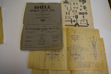
These items are from the Warrnambool Woollen Mill and relate to the fire protection services operating at the factory in the late 20th century. The Warrnambool Woollen Mill was commenced as a local public company and opened in 1910 in South Warrnambool with the first manager, John Bennett. During World War Two there were 700 employees at the mill due to wartime demand. In 1958 the factory became the first in Australia to manufacture electric blankets. In 1968 the mill was purchased by the Dunlop company and in 1982 Dunlop sold out to Onkaparinga Woollen Company which was taken over by Macquarie Worsteds and became known as Warrnambool Textiles. When Macquarie Worsteds ceased operations in Warrnambool the Smith Family managed the factory on behalf of the owners, the Warrnambool City Council. In 2000 the Woollen Mill closed and the site has been sold and developed as a housing estate.These items are of minor interest as mementoes of the Warrnambool Woollen Mill and will be added to the Woollen Mill collection in the Historical Society archives. .1 A sheet of white paper showing a sketch plan in black of the Warrnambool Woollen Mill with three areas coloured pink, yellow and blue .2 the same as .1 except that there are no shaded areas. .3 A sheet of lightweight card with black and yellow printing and a diagram of a machine Fire Plan For Insurance Purposes Atlas Automatic Fire Services Pty Ltd warrnambool woollen mill, history of warrnambool, onkaparinga woollen company, dunlop company -
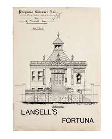 City of Greater Bendigo - Civic Collection
Booklet, Lansell's Fortuna, c 1980
Originally designed in 1857 and extended to the further designs by Bendigo Architects Vahland and Getzschmann, Emil Mauermann and William Beebe the original two story house expanded over time as Lansell's fortune increased and the subsequent mansion was built adjacent to the New Chum Reef and mine from which most of his wealth was yielded. Fortuna remained in the Lansell family for twenty nine years after George died and was sold by auction for demolition in 1934 only to be saved to become a reception house. In 1942 the Army acquired a lease for wartime mapping and occupied the site until 2008. It is now in private hands with the surrounding land being divided for housing. George Lansell was commonly known as 'Australia's Quartz-King' and director of thirty-eight mines with some link with almost every mine in Bendigo.A4 size tour booklet outlining the history, use and architectural features of Fortuna Villa which was purchased by George Lansell in 1860. mayor william beebe, george lansell -
 Kew Historical Society Inc
Plan, Melbourne & Metropolitan Board of Works : Borough of Kew : Detail Plan No.1571, 1904
The Melbourne and Metropolitan Board of Works (MMBW) plans were produced from the 1890s to the 1950s. They were crucial to the design and development of Melbourne's sewerage and drainage system. The plans, at a scale of 40 feet to 1 inch (1:480), provide a detailed historical record of Melbourne streetscapes and environmental features. Each plan covers one or two street blocks (roughly six streets), showing details of buildings, including garden layouts and ownership boundaries, and features such as laneways, drains, bridges, parks, municipal boundaries and other prominent landmarks as they existed at the time each plan was produced. (Source: State Library of Victoria)This plan forms part of a large group of MMBW plans and maps that was donated to the Society by the Mr Poulter, City Engineer of the City of Kew in 1989. Within this collection, thirty-five hand-coloured plans, backed with linen, are of statewide significance as they include annotations that provide details of construction materials used in buildings in the first decade of the 20th century as well as additional information about land ownership and usage. The copies in the Public Record Office Victoria and the State Library of Victoria are monochrome versions which do not denote building materials so that the maps in this collection are invaluable and unique tools for researchers and heritage consultants. A number of the plans are not held in the collection of the State Library of Victoria so they have the additional attribute of rarity.Original survey plan, issued by the MMBW to a contractor with responsibility for constructing sewers in the area identified on the plan within the Borough of Kew. The plan was at some stage hand-coloured, possibly by the contractor, but more likely by officers working in the Engineering Department of the Borough and later Town, then City of Kew. The hand-coloured sections of buildings on the plan were used to denote masonry or brick constructions (pink), weatherboard constructions (yellow), and public buildings (grey). This plan is the other half of Plan No.1571 representing the constructions to the west of Wellington Street before and in 1903/4. This plan represents the built environment in Edgevale Road, Wellington Street, Atkins Street, Annadale Street, Mortimer Street, and Cotham Road. Whereas there are smaller allotments and more modest housing stock facing Edgevale Road, larger blocks and more substantial houses are represented facing Cotham Road.melbourne and metropolitan board of works, detail plans, mmbw 1571, cartography