Showing 123797 items matching "main-road"
-
 Lakes Entrance Historical Society
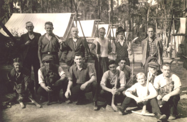
Photograph - The 4 Mile Camp Old Buchan Road, Buchan, East Gippsland Victoria, 1935-36
Relief gang burning charcoal for gas producers written on back of photograph but may be unemployed on Sustenance clearing roads and tracks. Tools shown axes, picks, fern hooks, slashers, sledghammers.Black and white photograph of fourteen men with two dogs and one cat at the single mens camp at The 4 Mile Old Buchan Road East Gippsland Victoria. Second photo shows some names from previous photo. Plus two other photos and names of same camp.( No names for last photo 05088.2)workmen, camp, topograpy, government services -
 Melbourne Tram Museum
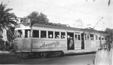
Photograph - Tram 493 advertising Savings Certificates, Ken Winney, May 1947
Black and white photograph showing W2 class tram 493 (City Route 4) in St Kilda Road, Prahran. One of several painted cream & dust colour advertising Savings Certificates. See item 6600 - image CC60 for a photo of the same tram at Franklin St. Photo by Ken Winney May 1947.Yields information about trams advertising Victory Bonds in 1947.Photograph with typed details on the rear.Typed "MMTB W2 car no. 493 in St Kilda Road, Prahran. One of several painted cream & dust colour advertising Victory Bonds and the K J Magor stamp with "K Winney" typed in. trams, tramways, w2 class, decorated trams, tram 493, st kilda road -
 The Beechworth Burke Museum
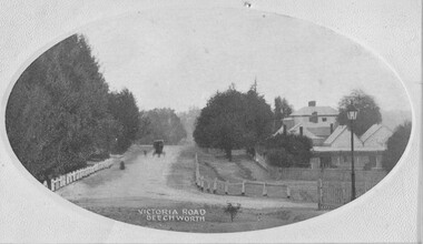
Photograph, c1910
Taken in Beechworth c1910, this postcard depicts Victoria Road lined with trees and residential houses. A horse and buggy is also pictured driving towards the camera. This postcard was manufacture by SEMCO or SEMCO Art Needlework Company, which was a "music, post-card and fine art importers, indentors and publishers" established by Stanley Edward Mullen in c1910, Melbourne. One of the identifying features of the Semco postcards is the text printed on the reverse of the cards which read: “Semco Series, P.O. Box 545, G.P.O. Melbourne.” Black and white postcard within oval frame, grey decorative edge. Obverse: VICTORIA ROAD, BEECHWORTH Reverse: 1997.2839 (crossed-out) A02839 84-137-1 POST CARD Near our state school. BEECHWORTH about 1910 beechworth, victoria road, postcard, 1910, semco -
 Kew Historical Society Inc
Photograph, Floods in North Kew, 1971
Living with natural processes was frequently a challenge to early European settlers and later residents of what was in the 1850s administered by the Borondara Road Board. This was compounded by the area being bounded on three sides by rivers (Yarra River, Koonung Creek and Gardiner's Creek). In 1849, the historian James Bonwick recorded that "our district [Kew] suffered considerably. Mr Wade speaks of 80 acres, out of 100 acres of his cultivated paddock, covered by water." Newspapers continued to describe major flooding in Kew in 1863, 1869, 1878, 1880, 1889, 1891, 1916 and 1934. While the construction of the Upper Yarra dam in 1957 reduced the levels of flowing downstream, local and riverine floods continue.The Kew Historical Society's pictures and map collections testify to the impact of flooding in the district. They have historical importance in documenting the extent of flooding in the district and its affects on homes, services and recreation. Numerous photographs record flooding throughout the Twentieth Century.Floods in North Kew, 1971. Looking northeast towards Kilby Road from River Avenue. Annotation on reverse: map and date "8 Nov. 71 10.30am".floods (kew), yarra river, kew flood, kilby road flood -
 Geelong Cycling Club
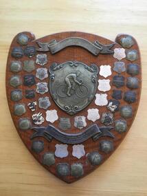
Shield, 1948
Team Road Races were a popular feature of club cycling in the Western District of Victoria during the second half of the 20th century. The shield was initiated by the Camperdown cycling club to record team winners of the races held between the clubs in the Western District of Victoria. This shield has an important place in the history of cycling in the Western District of Victoria. A large wooden shield with silver coloured plated plaques containing inscriptions of team winners of road races in the Western District of Victoria. There is a smaller shield in the centre of the shield depicting a cyclist and above and below this are banner like plaques with inscriptions on them. Many of the inscriptions have worn with age. "Perpetual Shield/Ian Davis - Gift Specialist/Camperdown .... CycleClub/Annual Western District/Teams Championship/1948/Terang ACC/No1 Team/1949/Terang ACC/No 1 Team/1950/Warrnambool ACC/No1 Team/1951/Warrnambool ACC/No1Team/1952/WarrnamboolACC/No1Team/1953/Sebastopol/ACC/1954/Sebastopol/ACC/1955/Geelong/No1 Team/1956/Camperdown ACC/1957/Sebastopol/No1 Team/1958/Geelong ACC/No1 Team/1959/Warrnambool ACC/No1 Team/1960/Geelong ACC/No1 Team/1961/Camperdown ACC/No 1 Team/1962/Geelong Camperdown/No1 Teams/ Equal/1963/Camperdown ACC/No 1 Team/1964/Geelong ACC/No 1 Team/1965/Geelong ACC/No 1 Team/1966/Geelong ACC/No 1 Team/1967/Geelong ACC/No 1 Team/1968/Geelong ACC/No 1 Team/1969/Geelong ACC/No 1 Team/1970/Geelong ACC/No 1 Team/1971-1976/inscriptions faded/1977/Warrnambool ACC/No1 Team/1978/Warrnambool ACC/No1 Team/1979/Geelong/N. Wilson/Godfrey/MacAuley/Hose/1980/Geelong/Inscriptions faded/1981/Geelong/G. Williams/N. Williams/D. Libbis/C. Judd/1982/Geelong/G. Williams/R. Bush/ P. Macauley/I. Wood/1983/Colac/P. Forster/P. Rippon/P. Taylor/D. Lunn/1984/Ballarat/Sebastopol/P. Taylor/M. Leverett/D. Keirl/1985/Geelong/D. Williams/G. Fitsimmons/B. Crane/L. Clinnick/1986/Colac/D. Lunn/C.Caspon/D. Allan/P. Jannsen/1987/Geelong/G. Williams/P. Macauley/B. Crane/D. Fitzsimmons/1988/.../1989/.../1990/Colac/C. Cashin/D. Forster/L. Nogera/S. Cropley/1991/Colace/C. Cashin/J. Stirling/S. Cropley/1992/Geelong West/D. Whitford/D. Wilson/P. Evans/M. Varker"perpetual shield; ian davis; annual western district teams championship; terang acc; warrnambool acc; sebastopol acc; geelong acc; camperdown acc; wilson; godfrey; macauley; hose; g. williams; n. williams; d. libbis; c. judd; r. bush; p. macauley; i. wood; colac; p. forster; p. rippon; p. taylor; d.lunn; ballarat; sebastopol; p. taylor; m. leverett; d. keirl; d. williams; g. fitsimmons; b. crane; l. clinnick; d. lunn; c.caspon; d. allan; p. jannsen; p. macaule; b. crane; d. fitzsimmons; c. cashin; d. forster; l. nogera; s. cropley; c. cashin; j. stirling; d. whitford; p. evans; m. varker; -
 Kew Historical Society Inc
Plan - Subdivision : Cotham and Glenferrie Roads, J R Mathers & McMillan
The Kew Historical Society's map collection includes a substantial number of real estate subdivision plans, mainly of Kew but also of surrounding suburbs in Melbourne. Most of the subdivision plans date from the 1920s and 1930s when the districts old homes and local farmland were being split up to accommodate residential growth in the postwar period. These early plans were assembled by a local firm, Jas R Mather & McMillan, which had an office in Cotham Road. Many of the plans, and sometimes photos, were annotated by the agents.Subdivision plans are historically important documents used as evidence for the growth of suburbs in Australia. They frequently provide information about when the land was sold as well as evidence relating to surveyors and real estate and financial agents. The numerous subdivision plans in the Kew Historical Society's collection represent working documents, ranging from the initial sketches made in planning a subdivision to printed plans on which auctioneers or agents listed the prices for which individual lots were sold. In a number of cases, the reverse of a subdivision plan in the collection includes a photograph of a house that was also for sale by the agent. These photographs provide significant heritage information relating house design and decoration, fencing and household gardens.The photograph may also be aesthetically significant depending on the importance of the photographic atelier.An undated and untitled hand-drawn and coloured subdivision plan detailing the boundaries of a number of irregular allotments bordering Cotham Road, Glenferrie Road and Stirling Avenue (now Stirling Street). The plan predates the actual subdivision that led to the creation of the eight commercial properties occupying 118-132 Cotham Road. The plan may represent an old subdivision that was further subdivided at a later date, or it may be a subdivision that never eventuated. On MMBW Detail Plan 1575 (1903), the area represented by the proposed subdivision was residential rather than commercial. The irregularity of lots is also apparent in the MMBW Plan. The largest of the unnumbered blocks on the hand-drawn subdivision plan may relate to the boundaries of the nineteenth century mansion identified as ‘Kelso’ on the MMBW Plan.subdivision plans - kew, cotham road - kew,, glenferrie road - kew , stirling avenue street - kew -
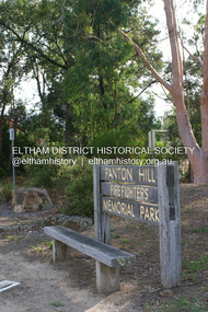 Eltham District Historical Society Inc
Photograph - Digital Photograph, Alan King, Panton Hill Fire Fighters Memorial Park, 2 February 2008
Five volunteer fire fighters who died in Upper Beaconsfield on Ash Wednesday, February 16, 1983, are honoured by the Panton Hill Fire Fighters Memorial Park on the main road. Published: Nillumbik Now and Then / Marguerite Marshall 2008; photographs Alan King with Marguerite Marshall.; p119This collection of almost 130 photos about places and people within the Shire of Nillumbik, an urban and rural municipality in Melbourne's north, contributes to an understanding of the history of the Shire. Published in 2008 immediately prior to the Black Saturday bushfires of February 7, 2009, it documents sites that were impacted, and in some cases destroyed by the fires. It includes photographs taken especially for the publication, creating a unique time capsule representing the Shire in the early 21st century. It remains the most recent comprehenesive publication devoted to the Shire's history connecting local residents to the past. nillumbik now and then (marshall-king) collection, panton hill fire fighters memorial park -
 Lake Bolac & District Historical Society
Black and white photograph, Lake Boloke Station woolshed
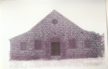
The Lake Boloke Station bluestone woolshed is located 4 kilometres north of Lake Bolac on the Back Bolac Road. Originally the main woolshed for the station. It was built by Robert Patterson in the mid 1860's but later owned by the Wills Family, as 'Fintry', following the subdivision of Lake Boloke Station.Black and white photographlake boloke, woolshed, bluestone, wills family, patterson, fintry -
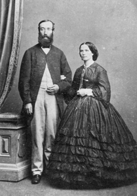 Stawell Historical Society Inc
Photograph, Mr David Scallan & his Wife -- Studio Portrait
Portrait of David Scallan & his Wife. David Scallan was a mining broker. David was also the first Shire President 1864 - 65. In 1864 he was a member of the Roads Board. Also, the first Committee of Management of Central Park. One of the main Stawell inner streets is Scallan St.Photograph of a woman and gentleman standing in a studio setting. Womans frock has a frilled skirt with long sleeves. Gentleman had light coloured trousers with a long dark coat buttoned at the neck. c 1865 - 70'sstawell -
 Kew Historical Society Inc
Photograph - Former Kew Post Office : Cotham Road elevation, 1996
A civic campaign for new public offices developed in Kew in the 1880s. After much deliberation, the location chosen was the junction of Bulleen and Cotham Roads. The buildings were designed by George Watson and John Henry Harvey, architects within the Department of Public Works (Victoria). Building was commenced in 1887, and after one year, the buildings were opened. The Post Office was transferred to the new Commonwealth Government in 1901. The Police Station and Court House, sold by the Victorian Government to the City of Boroondara in 2007, are now a community cultural centre and performing arts venue.The buildings were listed on the Victorian Heritage Register Register (HO885) in 1991. They are historically and architecturally significant to the State of Victoria because Watson and Harvey's designs exhibit diversity in integrating civil offices, they accommodate the apex of road junctions, and they demonstrate a departure from the contemporaneously favoured High Victorian Classical to the Queen Anne style in the design of civic buildings.View of the Kew Post Office, opened in 1888 which sits at the intersection of High Street and Cotham Road.The extension of the building at right was constructed in circa 1941. This view is of of the Cotham Road elevation.kew post office, cotham road -- kew (vic.), public offices -- kew (vic.) -
 Ballarat Tramway Museum
Photograph - Black & White Photograph/s, Wal Jack, 1935
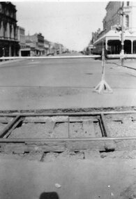
Black and white photograph of the former Phoenix Foundry railway line in Armstrong St. Ballarat crossing the Sturt St. (north side) tram line, looking south. Has Town Hall and Myer (formally Snows) building in the background, along with a tram stop on the corner. Track has been dug out, exposing the sleepers and one tie bar. Has road barriers in background. Photo taken1935, during the reconstruction of the tramway system. On Velox photo paper.On rear in top right hand corner in blue ink "12004". Above main writing in pencil is the number "74". On bottom half in light black ink "The old piece of Rly line in Armstrong St. crossing Sturt St. tram line Ballarat (1935)" In Wal Jack's handwriting.trams, tramways, phoenix foundry, armstrong st, sturt st, railway siding -
 Red Cliffs Military Museum
Copy of a letter, Letter to Walter West from W.H. Birdwood, 19/4/1919 (exact)
Sent by W.H. Birdwood but no signature. This is another of 5 documents in a large frame called the West Collectioncopy of typed letter to Walter West from W.H. BirdwoodTop left corner: Copy. Top right Australian Imperial Force 130 Horseferry Road, Westminster, S.W.1 19th April, 1919 Dear West, I send you my heartiest congratulations on the award to you of the Military Cross, of which I have only now been informed; in recognition of your very good and gallant work in our operations at Montbregain on 5th October last. When your platoon was held up by heavy fire from a strong post, you most gallantly rushed forwatd alone, and bombing the position captures the gun and crew. Later, when your flank could not make progress owing to fire from a post containing two machine guns, you crawled round to the right, and rushed this post, which you captured with one of the guns, killing three and taking another three of the garrison prisoners. On your company commander becoming casualty, you took command, and consolidated the line with good judgment and ability. throughout you displayed courage, initiative and determination of a very high order. I am indeed pleased that your splendid work has been recognised in this way. with kindest regards and good wishes to you for the future. Yours sincerely. W. H. Birdwood ww1, walter, thomas, west, mm, mc -
 Marysville & District Historical Society
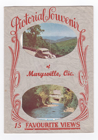
Postcard (item) - Colour and black and white photographs, Murray Views, Pictorial Souvenur of Marysville, Vic. 15 Favourite Views, 1950's
A fold out postcard of 15 colour and black and white photographs of scenes and landscapes in and around Marysville in Victoria.A fold out postcard of 15 colour and black and white photographs of scenes and landscapes in and around Marysville in Victoria. These photographs were produced by Murray Views in Gympie, Queensland as a souvenir of Marysville.Pictorial Souvenir/ of/ Marysville, Vic./ 15 Favourite Views PRODUCED BY MURRAY VIEWS. GYMPIE. Q. COPYRIGHT SAMUEL LEE & CO., PRINTERS Serial No. R 4152 NICHOLL'S LOOKOUT, MARYSVILLE, VIC. TAGGERTY RIVER, MARYSVILLE, VIC ROAD SCENE, MARYSVILLE, VIC. MAIN STREET, MARYSVILLE, VIC. THE CROSSWAYS, MARYSVILLE, VIC. FRUIT SALAD FARM, MARYSVILLE, VIC. ROAD TO CUMBERLAND VALLEY, MARYSVILLE, VIC. CROSSWAYS CABARET, MARYSVILLE, VIC. TREE FERNS, MARYSVILLE, VIC. STEVENSON'S FALLS, MARYSVILLE, VIC. Looking towards Marysville, Vic. Tourists at Marysville, Vic. Taggerty River, Marysville, Vic. On Buxton Road, Marysville, Vic. Panorama from Black Spur, Marysville Road, Marysville, Vic.marysville, victoria, souvenir, postcard, nicholl's lookout (image 1), taggerty river (image 2), road scene (image 3), main street marysville (image 4), crossways hotel (image 5), fruit salad farm (image 6), cumberland valley (image 7), crossways cabaret (image 8), tree ferns (image 9), steavenson falls (image 10), marysville view (image 11), tourists marysville (image 12), taggerty river (image 13), buxton road (image 14), black spur (image 15) -
 Warrnambool and District Historical Society Inc.
Medal - Cycling Medals W. S. Toyne
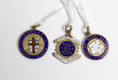
These cycling medals were awarded to W. S. Toyne. Two of these medals are time medallions relating to the Warrnambool to Melbourne Cycle Race. This race was first held in 1895 and continues to the present day. It was originally a handicap race from Warrnambool to Melbourne but after 1938 it became a Melbourne to Warrnambool race. After 1995 it became a scratch race and today the distance is shorter with the race starting from Avalon. It is the second oldest one-day cycling race in the world and the longest one-day cycling race in Australia. All riders who complete the race in a given time are awarded a Time Medallion. The race was sponsored by the Dunlop company from 1901 to 1927. In 1923, 123 of the 196 riders, who started at 5:30am completed the 165 mile road race and were awarded the time medallion. W. S. Toyne was listed among the some of the first cyclists to go through Camperdown at 8:16am. It was reported that over 50,000 spectators witnessed the progress of the race. These cycling medals belonged to a cyclist, W. S. Toyne, who completed in a significant sporting event in Warrnambool in 1923 and 1924. [.1] Round metal and enamel medal with blue enamel edge and an unidentified white coat of arms with a red cross containing five stars on the obverse side. The shield is held by an embossed kangaroo on the left and an emu on the right. The reverse is inscribed with name and time in an inner circle and the year and race on the outer edge. [.2] Round metal and enamel medal with blue enamel edge and a white enamel shield containing five stars in the centre of the obverse side. The reverse is inscribed with the name and time in the inner circle and the race name on the outer edge. [.3] metal and enamel medal with a blue enamel circle with white enamel boomerangs sitting above and below.[.1] Obverse: Dunlop Road Race; Reverse: Warrnambool-Melbourne Time Medallion 1924 Won by W. S. Toyne 5 Hrs. 47 Mns. 42 Sds. [.2] Obverse: Dunlop Road Race 1923; Reverse: Warrnambool-Melbourne Time Medallion; Won by W. S. TOYNE 10 Hrs. 30 Mns. Sds. [.3] Obverse: Barnet Glass Ballarat-Melbourne Road Race 1923; Reverse W. S. Toynew. s. toyne, dunlop road race, barnet glass road race, ballarat to melbourne cycle race, time medallions, warrnambool to melbourne cycle race -
 Whitehorse Historical Society Inc.
Document, History of Vermont State School, 1969
The History of Vermont State School, a committee was formed early 1869 and the School opened July, 1869.The History of Vermont State School, a committee was formed early 1869 and the School opened July, 1869. First Headmaster was 18 year old John Brown. The School was situated on corner of Delaney's Road and McGhee's Road, now Canterbury and Mitcham Roads.The History of Vermont State School, a committee was formed early 1869 and the School opened July, 1869. primary schools, vermont state school, no. 1022, brown, john, jane elizabeth, cooney, joseph, drummond, miss, rooks, abraham, smith, william, mcghees road, mitcham, delaney's road, mitcham road, vermont, canterbury road, boyle, david, mcsporran, mcclare -
Whitehorse Historical Society Inc.
Document, Municipal Chambers, Nunawading, 23/07/2001 12:00:00 AM
Papers relating to applications for Council permits, objections and VCAT hearingsPapers relating to applications for Council permits, objections and VCAT hearings concerning development of 360-362 Whitehorse Road, Nunawading, and of 13 Walkers Road, Nunawading. Includes maps, plans, photos and architectural assessment of 360 Whitehorse Road by Andrew Ward.Papers relating to applications for Council permits, objections and VCAT hearings associated planning consultants, arrowsmith, valda, nunawading and district historical society, municipal chambers, whitehorse road, nunawading, no 360, no 362, walkers road, no. 13, victorian civil and administrative tribunal, ward, andrew, city of whitehorse -
 Orbost & District Historical Society
book, Vic Roads Centenary 1913 -2013, 2013
The publication, VicRoads Centenary: Keeping Victorians Connected for 100 Years, looks at the people and projects that define VicRoads’ history. Written by current and former VicRoads’ employees, the publication details the organisation’s portfolio of major projects, which includes the Great Ocean Road, Hume Highway and Eastern Freeway. Other sections report on Victoria’s world-first road safety initiatives, VicRoads’ use of technology and sustainability measures. (ref VicRoads) This item is one of several books donated by David Jellie at a presentation to Orbost Historical Society. He was a contributor to the book and was the engineer for the Snowy River Bridge (Princes Highway) at Orbost 1974-1976.This book is a useful reference tool on the history of road construction in Victoria including East Gippsland.A thick, bound paperback book, titled "VicRoads Centenary Keeping Victorians Connected for 100 Years". On the front cover is a black/white photograph of two men working on a road. One has a pick. The book contains the history of VicRoads, photographs, maps and advertisements. Some are b/w. Others are coloured.vicroads book roads snowy-river-bridge jellie-david -
 Eltham District Historical Society Inc
Photograph - Aerial Photograph, Landata, Research, Vic, Apr. 1972
Centred on present day Main Road, Research near Maroondah Aqueduct and Eltham College bounded by Allendale Road to north, Research-Warrandyte Road to south, Swipers Gully Training Restaurant to east and Reynolds Road to west. Historic Aerial Imagery Source: Landata.vic.gov.au Aerial Photo Details: Project No :985 Project : MELBOURNE 1972 Run : 26 Frame : 194 Date : 04/1972 Film Type : B/W Camera : RC10 Flying Height : 5700 Scale : 9600 Film Number : 2636 GDA2020 : 37°42'07"S, 145°11'07"E MGA2020 : 340015, 5825692 (55) Melways : 22 H1 (ed. 42)aerial photo, neil webster collection, 1972-04, allendale road, eltham college, main road, maroondah aqueduct, melway 22h1, research (vic.), research-warrandyte road, reynolds road, swiper's gully -
Glenelg Shire Council Cultural Collection
Souvenir - Ruler - Road Safe, n.d
Green plastic ruler metric and imperial. 'When crossing the road Stop, Look, Listen and Think' in black print. Road Safe logo in black.ruler, stationery -
Whitehorse Historical Society Inc.
Article, Speed down to 60, 2014
Three kms of Blackburn Road in Blackburn South and 1.3 km in Boronia Road to be reduced from 70 km/h to 60 km/hThree kms of Blackburn Road in Blackburn South and 1.3 km in Boronia Road to be reduced from 70 km/h to 60 km/hThree kms of Blackburn Road in Blackburn South and 1.3 km in Boronia Road to be reduced from 70 km/h to 60 km/hvicroads, blackburn road, blackburn south, boronia road, vermont -
 Whitehorse Historical Society Inc.
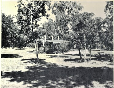
Photograph, Picnic Area at Antonio Park, 1983
Donor developed Educational Programme for Blackburn LakeLaser print of black and white photo of Picnic Area at Antonio Park, corner Deep Creek Road and Whitehorse Road , Mitcham. 1977. (Mounted)meagher, dorothy, antonio park, mitcham, deep creek road, mitcham, whitehorse road, mitcham -
 Whitehorse Historical Society Inc.
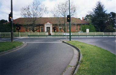
Photograph, Mitcham Primary School, 1/10/2000 12:00:00 AM
Coloured photograph of Mitcham Primary School, Mitcham Road, Mitcham taken from traffic lights on Doncaster East Road. Fence erected 2000.mitcham primary school, no. 2904 -
 Whitehorse Historical Society Inc.
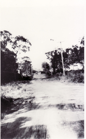
Photograph, Northcote Street, Mitcham, 8/09/1958 12:00:00 AM
Black and white photo of Northcote Street, Mitcham.- Eastern end of what is now Brunswick Road- Road (track ) conditions indicative of that part of the city.o'rourke, l. -
 Whitehorse Historical Society Inc.
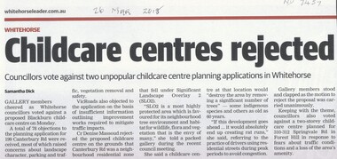
Article, Childcare Centres Rejected
Whitehorse councilors voted against a proposed childcare centre at 199 Canterbury Road, Blackburn and another at 310-312 Springvale Road, Forest Hill.Whitehorse councilors voted against a proposed childcare centre at 199 Canterbury Road, Blackburn and another at 310-312 Springvale Road, Forest Hill.Whitehorse councilors voted against a proposed childcare centre at 199 Canterbury Road, Blackburn and another at 310-312 Springvale Road, Forest Hill.city of whitehorse, child care centres, canterbury road, blackburn no. 199, springvale road, forest hill no 310 - 312 -
 Whitehorse Historical Society Inc.
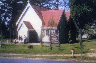
Photograph, St Luke's, Vermont
In 1922 the building was extended. In 1961 it was moved to it's present location at the rear of the church property. In 1999 it was restored and is now know as 'The Pioneer Church'Coloured photo of the original St Luke's Church, Vermont. It was erected on the corner of Mitcham Road & Canterbury Roads Vermont, and dedicated on 3rd September 1907st luke's vermont, canterbury road vermont -
Canterbury History Group
Photograph - Rear view of 3 shops in Maling Road. View from the Wattle Valley Road car park, Jan Pigot, 1994
Coloured photograph of the rear view of 3 shops, No. 114, 116 and 118 Maling Road. View from the Wattle Valley Road car park.canterbury, maling road, shops -
 Bendigo Historical Society Inc.
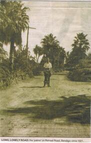
Newspaper - JENNY FOLEY COLLECTION: LONG LONELY ROAD
BHS CollectionBendigo Advertiser ''The way we were'' from 2002. Long lonely road: the palms on Retreat Road, Bendigo circa 1921. The clip is in a folder.newspaper, bendigo advertiser, the way we were -
 Ringwood and District Historical Society
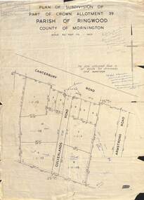
Map - Plan of Subdivision, Part of Crown Allotment 39, Parish of Ringwood, County of Mornington - (Undated - circa 1930s)
Copy of land title map on light cardboard backing showing layout and size of 11 allotments in Canterbury Road and Culverlands Road, Heathmont, Victoria. Hand-written sales notations on map and backing include names and telephone numbers - Mr Robinson MJ2411, Mr Smith MX5425, Abicare WY1848. Later notation 12/12/67 - A. Robertson. Rubber stamp imprint in top left corner - D.H. Oliver, Civil Engineer & Licensed Surveyor, Bellevue Street Lilydale, Phone Lilydale 91. -
 Kew Historical Society Inc
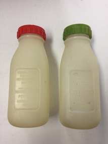
Container - Model Dairy Plastic Milk Bottles, Model Dairy, c.1960
This pair of milk bottles, produced for the Model Dairy in Cotham Road, Kew, were donated by Vik Sabaliauskas. They belonged to his father who worked at Model Dairy in the 1950s and 1960s. Vik wrote about his father: "As for my father, his whole life story is interesting. He was part of the big immigration program after WW2. He was a displaced person in Germany like lots of others who came out looking for a new life. Our family name is actually SABALIAUSKAS which is of Lithuanian descent. My Dad was also named Vik (Viktoras). He was known as Big Vik and I was little Vik. He arrived in Australia in 1947 and then did his 2 years of work organised by the Government and then he came to Melbourne. We lived in Tyler St Preston and he rode his pushbike to and from Kew every working day for years. In my estimation that was about 13 kms for about 6 or 7 years. Imagine that happening today. Freezing Winter mornings and hot Summer afternoons. His English was poor but he had a great work ethic like all European immigrants. His duties related to maintaining and operating all the machines. One story that he told me about was that after I was born (in 1959) he made friends with one of the drivers who delivered milk to the dairy. He asked him to get a container of milk from the farmer everyday which was just for me. I remember going to the Model Dairy Family Christmas parties which were always well patronised. I also remember visiting him in the PANCH Hospital (Bell Street Preston) where he was treated for kidney stones caused by drinking very creamy milk. He wasn't happy when he was told by the doctor to cut back on milk. My Dad was one month short of his 95th birthday when he died and he lived a pretty healthy life." (2019)Kew was a major milk producing district in the Nineteenth and early Twentieth centuries, with three major dairy farms lining the Yarra between Studley Park in the west and Burke Road in the east. In addition to these dairy producers, there were also a number of accredited dairy retailers in the suburb. The largest and most enduring of these was the Model Dairy founded by the Kew pioneer James Venn Morgan. Milk bottles that include the name of the producer or retailer are historically significant as they represent a period in Kew's history before the mass production of milk in the second half of the Twentieth Century. A number of these named bottles have the additional attribute of rarity.Pair of plastic milk bottles, designated on the front as to be used in the refigerator on on picnics. One bottle has a red screw on lid and the other a green lid. The bottles are semi-transparent. [The record also includes a photograph of Vic Sabaliauskas, provided by his son. The photograph dates from the period when he was employed at the Model Dairy].Impressed on the front of both bottles: "Unbreakable picnic and refrigerator bottle made expressly for Model Dairy Pty Ltd Cotham Rd Kew"dairies - kew, model dairy - cotham road - kew (vic) -
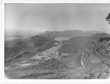 Halls Gap & Grampians Historical Society
Photograph - B/W
Photo has been taken from Boroka Peak/lookout, of the Fyans Valley and the township of Halls Gap. The Grampians/Dunkeld Road can be seen running North/South along the right edge of the valley and Lake Bellfield is the water at the end of the valley. Photo is typical of those taken by Forrests Commission at the timea photo of a valley, mostly cleared, flanked by two mountain ranges. A large body of water can be seen at the far end of the valley (middle of photo). Buildings and roads visible in the valley. Plains can be seen beyond the far mountain range on the left side of the scene.no.42scenery, fyans valley