Showing 269 items matching "aerial surveys"
-
 University of Melbourne, Burnley Campus Archives
Plan, Wilsons Promontory8119-I and Glennie 8119-IV, 1971
... aerial survey...State Aerial Survey Plan of Wilsons Promontory and Glennie... aerial survey State Aerial Survey Plan of Wilsons Promontory ...State Aerial Survey Plan of Wilsons Promontory and Glennie. Dated 1971. Provisional Compilation of Sheets 8119-I and 8119-IV from Commonwealth Department of National Development Photography for the Department of Crown Lands and Survey Victoria. Students made excursions to Wilsons Promontory.wilsons promontory, glennie group, anser group, bass strait, aerial survey -
Southern Sherbrooke Historical Society Inc.
Map, Dept of land s & Survey, Dandenong Ranges Area Sheet 28, Jan-56
... Aerial survey map of parts of Gembrook, Monbulk and Naree... left corner of reverse. Aerial survey map of parts of Gembrook ...Owned by David Walker, previously of Menzies Creek. Given by him to Rex Breen in 2001 for donation to society.Aerial survey map of parts of Gembrook, Monbulk and Naree Worran parishes (Victoria). Scale: 10 chains to 1 inch, contour interval 20 feet. Shows Menzies Creek and parts of Kallista, Clematis, Selby and Belgrave South. Ringwood D2C or 849D2C, Zone 7"16563" in pen on top left corner of reverse. -
Whitehorse Historical Society Inc.
Map, Melbourne Metropolitan Area Base Map series. Sheet 214, c1960
... increments. Note on map: 'prepared ... from State Aerial Survey... on map: 'prepared ... from State Aerial Survey, January 1957 ...Map showing northern section of the City of Nunawading together with parts of Shire of Doncaster and Templestowe.Map showing northern section of the City of Nunawading together with parts of Shire of Doncaster and Templestowe. Shows roads, creeks, block numbers and contours at 5 feet vertical increments. Note on map: 'prepared ... from State Aerial Survey, January 1957 and Cadastral Survey information February 1959'.Map showing northern section of the City of Nunawading together with parts of Shire of Doncaster and Templestowe. maps, city of nunawading, shire of doncaster and templestowe -
Port Melbourne Historical & Preservation Society
Photograph, Aerial Survey of Port Melbourne; December 1945, 2105
... Aerial Survey of Port Melbourne; December 1945...Aerial Survey of Port Melbourne; December 1945 Large... areas on map . PMHPS logo on top left corner Aerial Survey ...Seventeen (17) individual photos were joined together by John KIRBY to make a compsite image.Aerial Survey of Port Melbourne; December 1945 Large photograph mounted on foam board. Shows aerial view of Port Melbourne showing its extent from the Bay. Panel on right hand side has key to numbered areas on map . PMHPS logo on top left cornereclipse picture theatre, brookes lemos ltd, built environment, local government, natural environment, built environment - industrial, religion - roman catholic church (st josephs), gmh, general motors-holden, rotten row, sport - trotting, j kitchen & sons pty ltd, australian wool board, government aircraft factory, gaf, commonwealth aircraft corporation, cac, north port oval, fire and fire services, market reserve, religion - presbyterian church, leading lights, foresters arms hotel, commonwealth government engine works, st josephs catholic primary school, mission to seamen, centenary bridge, naval drill hall, mail exchange, gasworks, piers and wharves - town pier, robert harper & co ltd, ran - royal australian navy, hmas lonsdale, port melbourne yacht club, pmyc -
 Bendigo Historical Society Inc.
Map - FRED COWIE COLLECTION: AERIAL MAPS OF HEATHCOTE/EPPALOCK, 28-9-1960
... through town branching off to Bendigo & Echuca. Aerial Survey... branching off to Bendigo & Echuca. Aerial Survey of Victoria. Photo ...Map, Heathcote C2, Township of Heathcote, Melbourne Road through town branching off to Bendigo & Echuca. Aerial Survey of Victoria. Photo-map prepared by Department of Crown Lands and Survey from photographs taken in 1960. Copied photographically at the Central Plan Office.Fred Cowie,46 McIvor Rd,Bgo..Central Plan Officemap, heathcote, fred cowie -
 Bendigo Historical Society Inc.
Map - FRED COWIE COLLECTION: AERIAL MAPS OF HEATHCOTE/EPPALOCK, 28-9-60
... Map, Heathcote C4, Aerial Survey of Victoria,Photo-map..., Heathcote C4, Aerial Survey of Victoria,Photo-map prepared ...Map, Heathcote C4, Aerial Survey of Victoria,Photo-map prepared by Department of Crown Lands and Survey from photographs taken in 1960. Copied photographically at the Central Plan Office.Date 28-9-60,C.P.O.Neg.No.21590.Scale 4 inches to 1 mile. Fred Cowie,46 McIvor Rd,Bgo..Central Plan Office.map, heathcote, fred cowie -
 Bendigo Historical Society Inc.
Map - FRED COWIE COLLECTION: AERIAL MAPS OF HEATHCOTE/EPPALOCK, 28-9-60
... Map, Heathcote C3, Aerial Survey of Victoria, Photo-map..., Heathcote C3, Aerial Survey of Victoria, Photo-map prepared ...Map, Heathcote C3, Aerial Survey of Victoria, Photo-map prepared by Department of Crown Lands and Survey from photographs taken in 1960.Copied photographically at the Central Plan Office. Date 28-9 60, C.P.O.Neg. No.21588.Campaspe River, Coliban River. Flower Hill. Fred Cowie,46 McIvor Rd.Bendigo (Not located 29.9.2022)Central Plan Office.map, heathcote, fred cowie -
Creswick Campus Historical Collection - University of Melbourne
Still Image, 1952
... of a topographical map marked State Aerial Survey. Stored in a brown... section of a topographical map marked State Aerial Survey. Stored ...Subject: King Lake . 6 brown envelopes marked Run 3, 4, 7, 7a, 8, 9 containing c. 80 prints. 1 section of a topographical map marked State Aerial Survey. Stored in a brown cardboard file box marked King Lake Run No.3 - 9. (x9). Photos commissioned by Forests Commission Victoria.Aerial Photographs -
 City of Kingston
Photograph - Black and white, Aerial photograph Highett, 26 March 1956
... Part of broad aerial photographic survey of the area...Part of broad aerial photographic survey of the area ...Part of broad aerial photographic survey of the area. Aerial photograph Highett - Highett Reserve, Sandpits, Gasworks, Nepean Highway, Chesterville Road, Wickham Road.The photograph shows the development of the city of Highett, suburban expansion and industrialisationsquare black and white photographic print on paper, with thick black border; printed text on bottom indicating date and other reference codeshighett, city of moorabbin, aerial photograph, suburbs, highett gas works, recreation, infrastructure -
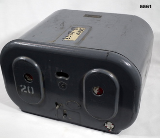 Bendigo Military Museum
Magazine - MAGAZINE, FILM, Williamson Manufacturing Co Ltd
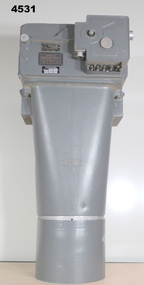
... aircraft, did aerial survey work in PNG, Indonesia, Malaysia... aircraft, did aerial survey work in PNG, Indonesia, Malaysia ...This photographic magazine attaches to the gear box universal ( see cat 4531). As an assembly, the type F22 aerial camera came into RAF and RAAF service c1942. It was used by the RAF over Europe and by the RAAF extensively through the Sth. West Pacific area of operations, during WW2. This type of camera was used through the Vietnam war up to the early 1980's. The F22 camera assembly when mounted in the reliable Canberra aircraft, did aerial survey work in PNG, Indonesia, Malaysia and Sumatra and the Australian mainland. This type of camera was used in Spitfires, Mosquitos, Avro Lincolns and Canberra aircraft.This is a heavy metal container painted in a grey colour. The label is on the top. One side has two enlarged oval sections. in those two ovals is one hole of 22 mm diameter. In those holes is a disc painted half red and half white. Below the ovals are two levers connected to the internal mechanism. Bottom RHS has a disc with 2 pins, red dots are printed on it. Nearly level with the top of ovals is a kidney shaped hole. In that hole is a rotating disc with graduations and numbers. the action side of magazine has a rectangular opening size 83/4" x 7/16". It is covered with a black soft material.Top has “serv 18-10-73” The number '20' has been stenciled on two surfaces.aerial photography, magazine, ww2, raaf -
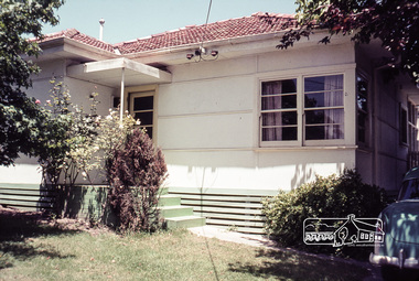 Eltham District Historical Society Inc
Photograph, First house in Pryor Street, Eltham, c.1965, 1965c
... by the time of the 1951 aerial survey. The house was also the first... by the time of the 1951 aerial survey. The house was also the first ...This was the first house on Pryor Street which was located at the corner of what is now Commercial Place on the eastern side. Originally there was another house adjacent but it had been moved by the time of the 1951 aerial survey. The house was also the first home of Russell Yeoman who had been newly appointed to the Shire of Eltham and this house belonging to the council was vacant and made available to him for four weeks before it was relocated to Susan Street just south of the bowls club and was used a child care centre associated with the Living and Learning Centre (Russell believes). Russell then moved into another council owned house at the corner of Susan and Bridge Streets.Digital file only; created from original colour positive slide transparencyeltham, streets, houses, pryor street, susan street, fe holden sedan, russell yeoman collection -
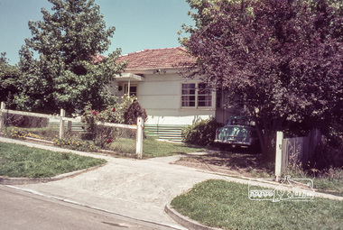 Eltham District Historical Society Inc
Photograph, First house in Pryor Street, Eltham, c.1965, 1965c
... by the time of the 1951 aerial survey. The house was also the first... by the time of the 1951 aerial survey. The house was also the first ...This was the first house on Pryor Street which was located at the corner of what is now Commercial Place on the eastern side. Originally there was another house adjacent but it had been moved by the time of the 1951 aerial survey. The house was also the first home of Russell Yeoman who had been newly appointed to the Shire of Eltham and this house belonging to the council was vacant and made available to him for four weeks before it was relocated to Susan Street just south of the bowls club and was used a child care centre associated with the Living and Learning Centre (Russell believes). Russell then moved into another council owned house at the corner of Susan and Bridge Streets.Digital file only; created from original colour positive slide transparencyeltham, streets, houses, pryor street, susan street, russell yeoman collection, fc holden sedan -
 Bendigo Military Museum
Equipment - AIR CAMERA ACCESSORY, Williamson Mfg. Co. Ltd
... aircraft, did aerial survey work in PNG, Indonesia, Malaysia... aircraft, did aerial survey work in PNG, Indonesia, Malaysia ...This Gear box universal, with its Cone assembly ( inc lens) in conjunction with Magazine 500 exposures unit ( see CAT 5561) is part of the F22 aerial camera assembly. As an assembly, the type F22 aerial camera came into RAF and RAAF service c1942. It was used by the RAF over Europe and by the RAAF extensively through the Sth. West Pacific area of operations, during WW2. This type of camera was used through the Vietnam war up to the early 1980's. The F22 camera assembly when mounted in the reliable Canberra aircraft, did aerial survey work in PNG, Indonesia, Malaysia and Sumatra and the Australian mainland. This type of camera was used in Spitfires, Mosquitos, Avro Lincolns and Canberra aircraft.Heavy, metal construction. The base is a rectangular box shape and mounted to that is a funnel shaped tube. Inside the tube are numerous small baffles around the sides painted matte black. The box has a 7 pin electrical connector. The box section can be opened by releasing catches. It has a timber base. Near the mouth of the tube, outside, is a panel with a slot and indentations F5.6 F8 F11 F16.There is a tape label near mouth if tube with writing embossed "LENS S/NO 2767849" The box has a label "GEARBOX/UNIVERSAL. MODEL 14A/4249 SERIAL No. 1685"aviation, reconnaisance, camera, photography -
 Bendigo Historical Society Inc.
Document - VARIOUS DOCUMENTS FROM 'BOX 511'
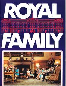
... unknown (no cover); h. 'Hobart and Suburbs' = Aerial Survey Maps... unknown (no cover); h. 'Hobart and Suburbs' = Aerial Survey Maps ...Various documents from 'Box 511': a. 'Royal Family' - re filmed portrait of Queen Elizabeth II (1959); b. 'Scientific American', issue of April 1934; c. 'Band of Hope Review, 1867 - published in England (Baptist); d. 'Beautiful Britain' - Art Series No 6 - Scenery of the United Kingdom, m1894; e. as for d. but Series 10; f. as for d. but Series 11; g. as for d. but Series unknown (no cover); h. 'Hobart and Suburbs' = Aerial Survey Maps (street directory), 1954 - ex libris A. Richardson, 1959; I. 'Weekly Times Annual, Dec 10, 1931 - cover and pages missing; j. 'Table Talk Christmas Annual, Dec 3, 1923 (cover and pages missing)document -
 Ringwood and District Historical Society
Map - State Aerial Survey, Dandenong Ranges Area, Parts of Parishes of Nunawading, Warrandyte and Ringwood - 1956
... State Aerial Survey..., July 1956, from aerial photographs and Cadastral Survey..., July 1956, from aerial photographs and Cadastral Survey ...Map of Ringwood North and parts of Mitcham, Donvale, Park Orchards and Ringwood East compiled by Dept of Lands and Survey, July 1956, from aerial photographs and Cadastral Survey information. Sheet 1, Ringwood A2D or 849 A2D Zone 7. Scale: 4 chains to 1 inch. Contour interval 20 feet. -
 Bendigo Military Museum
Photograph - Army Survey Regiment aerial photos, Fortuna, Bendigo, c1990
... Army Survey Regiment aerial photos, Fortuna, Bendigo...Army Survey Regiment aerial photos, Fortuna, Bendigo...This is a set of two aerial photographs of the Army Survey... goldfields This is a set of two aerial photographs of the Army Survey ...This is a set of two aerial photographs of the Army Survey Regiment, Fortuna, Bendigo taken in c1990. These photos are indicative of a series of 23 aerial photos in the collection taken from multiple angles and elevations. It is possible the photographs were taken from a hot air balloon. The approximate date of the photos is based on the existence of the new printing building - Wazgoose Hall and the new records building.This is a set of two aerial photographs of the Army Survey Regiment, Fortuna, Bendigo taken circa 1990. Colour photographs are on photographic paper and scanned at 300 dpi. They are part of the Army Survey Regiment’s Collection. .1) to .2) - Photo, colour, c1990. Army Survey Regiment aerial photos.royal australian survey corps, rasvy, army survey regiment, army svy regt, fortuna, asr -
Moorabbin Air Museum
Document (Item) - (SP) CAC History Boomerang Description WS Robinson File No 1 7.1.1935 to 18.8.1942 Various Correspondence R3
... Corporation to carry out a 12-month aerial photographic survey. He... Corporation to carry out a 12-month aerial photographic survey. He ...Correspondence Notes on the "Boomerang" Interceptor 18/8/42 Correspondence re setting up aircraft industry in Australia - between W S Robinson, A G Brown (CAC), S A Middleton (Austral Development Ltd London.), Douglas Aircraft Company, F Mitchell, BHP,, Essiungton Lewis BHP, Australian William S. Robinson had been Managing Director of Broken Hill Associated Smelters, based in London. He had played a key roll in negotiating the British Zinc Corporation’s investment in mining at Broken Hill NSW and formation of the resultant Australian business The Zinc Corporation. Returning to Australia, he was appointed to high levels of Australian Government during the Second World War to formulate policy on wartime demands for Australia's industrial and metals supply. Robinson was held in high regard by successive Prime Ministers and was a close associate of Essington Lewis, head of Broken Hill Pty Ltd (BHP). W.S. Robinson was a strong believer in aviation and business and air transportation having backed the purchase of two DH.84 Dragons in 1933 by associate company Western Mining Corporation to carry out a 12-month aerial photographic survey. He promoted the formation of Commonwealth Aircraft Corporation at Fishermans Bend, Melbourne to ensure Australian production of military aircraft. -
Moorabbin Air Museum
Document (Item) - (SP) CAC History Aviation Syndicate Minutes and Agenda
... Corporation to carry out a 12-month aerial photographic survey. He... Corporation to carry out a 12-month aerial photographic survey. He ...Correspondence Notes on the "Boomerang" Interceptor 18/8/42 Correspondence re setting up aircraft industry in Australia - between W S Robinson, A G Brown (CAC), S A Middleton (Austral Development Ltd London.), Douglas Aircraft Company, F Mitchell, BHP,, Essiungton Lewis BHP, Australian William S. Robinson had been Managing Director of Broken Hill Associated Smelters, based in London. He had played a key roll in negotiating the British Zinc Corporation’s investment in mining at Broken Hill NSW and formation of the resultant Australian business The Zinc Corporation. Returning to Australia, he was appointed to high levels of Australian Government during the Second World War to formulate policy on wartime demands for Australia's industrial and metals supply. Robinson was held in high regard by successive Prime Ministers and was a close associate of Essington Lewis, head of Broken Hill Pty Ltd (BHP). W.S. Robinson was a strong believer in aviation and business and air transportation having backed the purchase of two DH.84 Dragons in 1933 by associate company Western Mining Corporation to carry out a 12-month aerial photographic survey. He promoted the formation of Commonwealth Aircraft Corporation at Fishermans Bend, Melbourne to ensure Australian production of military aircraft. -
 Ringwood and District Historical Society
Map - State Aerial Survey, Dandenong Ranges Area Sheet 7, Parishes of Warrandyte, Scoresby, Ringwood and Nunawading - 1956
... State Aerial Survey..., July 1956, from aerial photographs and Cadastral Survey... aerial photographs and Cadastral Survey information. Subsequent ...Map of central and southern areas of Ringwood and part of Ringwood East and Heathmont compiled by Dept of Lands and Survey, July 1956, from aerial photographs and Cadastral Survey information. Subsequent coloured hand-drawn additions showing layout of a number of post-NSW Separation era proposed subdivisions that did not eventuate, including Village of Studley Estate, Township of East Kew Estate, Township of Ballyduffy Estate, Township of New Flemington Estate, Township of East Hawthorne Estate. Ringwood A4B2, 849 A4B Zone 7. Scale: 10 chains to 1 inch. Contour interval 20 feet. -
 Ringwood and District Historical Society
Map - State Aerial Survey, Dandenong Ranges Area, Parishes of Warrandyte and Ringwood - 1956
... State Aerial Survey..., July 1956, from aerial photographs and Cadastral Survey... aerial photographs and Cadastral Survey information. Subsequent ...Map of central and southern areas of Ringwood and part of Ringwood East and Heathmont compiled by Dept of Lands and Survey, July 1956, from aerial photographs and Cadastral Survey information. Subsequent hand-drawn addition of streets showing layout of "Township of Ballyduffy Estate 1858-60", an earlier proposed subdivision that did not eventuate. (See attached 5009b Ballyshanassy_ Melbourne’s lost suburb.pdf for Ballyduffy historical naming relevance). Ballyduffy Estate streets include City Road, West Prussia Road, Duffy Street, Ireland Street, Evans Street, Victoria Street, Regina Street, Short Road, Prussia Road, Duffy Street East, Ireland Street East, Evans Street East, Chapman Street. Misc Topo 93 Sheet 22, Ringwood A4B2. Scale: 4 chains to 1 inch. Contour interval 20 feet. -
 Bendigo Military Museum
Pamphlet - An Introduction to Topographic Mapping, C 1991
... map production: Establish Survey Control, Aerial Photography... map production: Establish Survey Control, Aerial Photography ...This pamphlet was published by the Army Survey Regiment as an overview of the Royal Australian Survey Corps (RASvy), its role and unit structure circa 1991, prior to RASvy’s disbandment in 1996. The pamphlet comprehensively detailed the eight steps of topographic map production: Establish Survey Control, Aerial Photography, Aerotriangulation, Stereoplotting, Field Verification, Cartography, Printing and Storage/Map Distribution. Leading technologies used by RA Svy in 1991 included GPS control surveys, 5 colour printing on the Speedmaster offset press and bulk map packaging using the Map Handling Station (with guillotine). Digital map production was operating on the AUTOMAP 2 system, before the “Newheart” system upgrade two years later. Printed on the pamphlet cover was a portion of the plane tabled “four inches to a mile” map of Newcastle. This was compiled and surveyed in 1910 by LCPL A. Barrett, a member of the RAE Detachment, as part of the first major topographic mapping effort of Australia.This is a Royal Australian Survey Corp pamphlet with a historical map printed in colour on cardboard on both sides of the cover. There are 16 pages printed in colour on gloss paper, with photos, diagrams and descriptions. The pamphlet is bounded by two staples on its spine. Each of the 17 images were scanned at 300 dpi in JPEG (.jpg) format and stored on the attached 16 Gb USB memory stick. The images have been converted into MPEG-4 (.mp4) video format, 4Mb in size and runs for 2:16 minutes and is also stored on the memory stick.royal australian survey corps, rasvy, fortuna, army survey regiment, army svy regt, asr -
 Bendigo Military Museum
Magazine - "Parare" Survey Corps Magazine Issue 9, Royal Australian Survey Corps, 1993
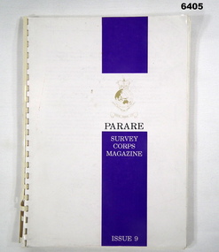
... Project page 92. Royal Australian Survey Corps Aerial photography... 92. Royal Australian Survey Corps Aerial photography Team ...An annual magazine published for release on RASvy Corps birthday 1st July. All units with RASvy Corps are invited / expected to submit an article depicting their activities over the preceding years 1991 to 1993. 4Fd Svy Sqn Adventure training list pages 7, 8. Army Map Depot - Unit Ski Day, pages 20, 21. The William Patton Expedition - Locating his grave as part of the " Burke and Wills " expedition, list of personnel involved - page 43. 8 Fd Svy Sqn - names mentioned and photo - page 50. 4 Fd Svy Sqn (1992) names mentioned page 69. The G Res manning list on page 70. Names mentioned in "Unit sports pages 73, 74. Exercise Kokoda Cartographer July 1992 list of participants on Page 78. Iraq - The Gulf War, Topographic Support page 52. Adelaide (4 Fd Svy Sqn) 1992 page 65. 8 Fd Svy Sqn manning wind down list pages 89-90. Military Geographic Information Pilot Project page 92. Royal Australian Survey Corps Aerial photography Team personnel list page 95. Operation Belama 92 Team list page 96. Long term Schooling attendees and promotions, page 105. Litho Sqn Postings in and out pages 116-117. Special awards SGT Durrant page 113, SSGT SR Hill page 114. RASvy completes 1:50,000 scale mapping of the Pilbara Region page 121. 1st Topo Svy Sqn personnel mentioned on page 122. A4 sized booklet with soft glossy card covers, paper pages held together with a plastic spiral binder.army survey regiment, army survey regt, fortuna, royal australian survey corps, rasvy, asr -
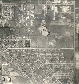
 Ringwood and District Historical Society
Photograph, Composite Aerial Views of Ringwood, Victoria - 1972
Two composite black & white aerial photographs with north-facing view over Maroondah Highway, including Railway Station precinct, Civic Centre precinct, Eastland, Mount Dandenong Road, Bedford Road, Ringwood Street, Warrandyte Road, Mullum Road, Loughnan's Road.Department of Crown Lands and Survey. Maroondah Highway Project - Run 3 - 20.1.72 - 3,900' ASL. -
 Ringwood and District Historical Society
Article - Newspaper Clipping, Land Sale Advertisements, Golden Hill Estate, Ringwood - 1965, 1966, and Plan of Survey of Lot 8, Mullum Mullum Road Ringwood, 1970
Newspaper clippings from Melbourne Sun newspaper (11th December 1965 and 15th January 1966) advertising sale of land - Golden Hill Estate, Ringwood, with summary of features and aerial photograph including artistic representation of street layout. Subdivision includes Mullum Mullum Road, Sonia Street, Jill Court, Linda Drive, Eve Court, Alma Court, and Jacynthe Court. Attachments include reference to Lot 46 as site of original Peter Vergers' orchard residence and subsequent 1970 surveyor's Plan of Survey of Lot 8 Mullum Mullum Road Ringwood, LP 67513, Cert of Title 8581/429.Agent - Aaron, King & Co., Suite 2, 33 Queens Road, Melbourne. (Phone) 26-2443, A.H. 850-2195. Plan of Survey signed on 25.7.1970 by Roger M. Gamble, Land Surveyor, 28 Summit Crescent, Ringwood 3134. -
 Bendigo Military Museum
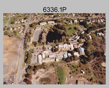
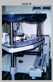
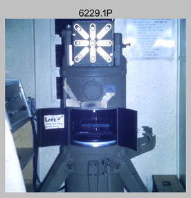
Photograph - Orthorectification Equipment - Army Survey Regiment, Fortuna, Bendigo, c1975, c1988
Orthophoto mapping provided the Survey Corps with the capability to produce map products quickly in the event of a crisis. These are four photographs of equipment used by the Army Survey Regiment to produce orthophotomaps. The Wild GZ1 orthophoto projector shown in photo.1P was introduced in 1973 and was the first equipment used to orthorectify colour and monochrome film aerial photography. Height profiles were originally produced on a PEB8 Stereo profiler and later were software generated. Photos of the PEB8 are available in Victorian Collections item 6222.17P, photos .5P and .6P. In the same era the IBM 1130 computer; OMI/Nistri AP/C-3 analytical plotter with coordinatograph, OP/C orthophoto projector and Zeiss Planimat D2 stereoplotters were introduced. Orthorectification is the process of removing geometric distortions and scale errors/variations from images. Images have tilt and relief distortions that make it difficult to compare accurately a map and an image of the same geographic area. Once an image is orthorectified, features on the image are shown in their planimetric locations. The WILD OR1 orthophoto projector and workstation shown in photos .2P to.4P was introduced in the mid-1980s. It was the second-generation equipment used to orthorectify colour and monochrome film aerial photography, replacing the system introduced in 1973. See items 6124.5P and 6133.4P for more photographs of orthorectification equipment.These four photographs of orthorectification equipment were taken at the Army Survey Regiment at Fortuna, Bendigo, c1975 and c1988. The photos are on 35mm colour slides and scanned at 96 dpi. They are part of the Army Survey Regiment’s Collection. .1) - Photo, colour, c1975, Wild GZ1 orthophoto projector. .2) - Photo, colour, c1988, WILD OR-1 unrectified colour photo in carrier, orthorectified and re-scaled colour image. .3) & .4) - Photo, colour, c1988, WILD OR-1 Orthorectification Workstation.1P to .4P – Some of the equipment is annotated on the frame of the 35mm slides.royal australian survey corps, rasvy, army survey regiment, asr, army svy regt, fortuna -
 Bendigo Military Museum
Photograph - Photo Troop Equipment, Lithographic Squadron – Army Survey Regiment, Fortuna, Bendigo, c1970s
... at Lithographic Squadron, Army Survey Regiment, Fortuna, Bendigo in c1970s ...This collection of five photos was most likely taken at Lithographic Squadron, Army Survey Regiment, Fortuna, Bendigo in c1970s. The main tasks undertaken by technicians in Photo Troop were most likely enlargements, reductions and duplication of map reproduction material, and processing of aerial photography.This is a set of five photographs of Photo Troop equipment was taken in Lithographic Squadron, at the Army Survey Regiment, Fortuna, Bendigo, c1970s. The photographs are on 35mm colour slides and were scanned at 96 dpi. They are part of the Army Survey Regiment’s Collection. .1) - Photo, colour, c1970s, WILD U4A Diapositive Camera. .2) - Photo, colour, c1970s, Hass-Labortechnik Film and Paper Roller Transport Processor. .3) - Photo, colour, c1970s, Hass-Labortechnik Film and Paper Roller Transport Processor, SGT Christopher Wardley. .4) - Photo, colour, c1970s, Hass-Labortechnik Film and Paper Roller Transport Processor, unidentified technician. .5) - Photo, colour, c1970s, Pako Film Processor..1P to .5P – Some of the equipment is annotated on the frame of the 35mm slides.royal australian survey corps, rasvy, army survey regiment, army svy regt, asr, fortuna, litho -
 Bendigo Military Museum
Article - Aerial photography Diapositive Filter Plate, circa 1960
Aerial photography glass plate filter used in the production of aerial photography for mappingWooden box, lacquered, hinges and clasps, blue felt lined, glass plateroyal australian survey corps, rasvy, fortuna, army survey regiment, army svy regt, asr -
 Bendigo Military Museum
Administrative record - Joint Committee for the exchange of Information on ADP within the RASvy Corps, Activities Jun- Dec 1985, Army Survey Regiment, December 1985
Automated Computer Processing (ADP) was instrumental to the successful operation of the Royal Australian Survey Corps Mapping capability and production. This paper describes elements of the ADP with a comprehensive description of each. They Include, PDP 11/70 Memory, Map Stock Control System, Digital Terrain Elevation Data, Digital Terrain Model Package, ASMAPS, ASTIS, Reflectance Hill Shading, Aerial Triangulation and Terrain Analysis.Two page paper report about Automated Data Processing, unstapledHand annotated "Folio 74" in top right hand cornerroyal australian survey corps, rasvy, fortuna, army survey regiment, army svy regt, asr -
 Bendigo Military Museum
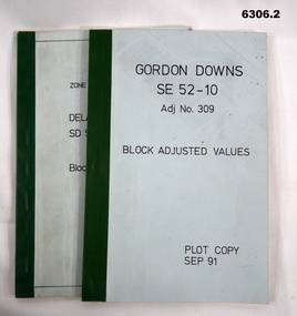
Administrative record - Report on the Block Adjustment of the Gordon Downs and Delemere 1:250,000 Maps, Army Survey Regiment, 1 Sep 1991, .2 Jan 1988
All mapping produced at this time were produced using Aerial Photography. These booklets contain the adjusted mathematical solution to joining this group of photographs together..1 Blue covered booklet with green tape binding. Block adjusted values for Gordon Downs SE 52-10 1:250 000 map Adjustment number 309 Sep 1991 .2 Blue covered booklet with green tape binding. Block adjusted values for Delamere SD 52-16 1:250 000 map Adjustment number 272 Jan 1988royal australian survey corps, rasvy, fortuna, army survey regiment, army svy regt, asr -
 Bendigo Military Museum
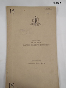
Manual - Australian Survey Corps 1947 - Instructions for the use of Slotted Template Equipment, Australian Survey Corps, 1947
This is an instruction manual describing in detail the construction of the templates used for producing map compilation sheets from aerial photographs, and how the system works.Foolscap size, soft carboard covers, 9 x numbered pages, 3 x fold out pages containing two photos on each. Australian Survey Corps Badge on cover. Stapled and re-stapled on Left hand edge.Front Cover, "15" Top Left and Bottom Left corner, "COOPER" and stamped "58" in Top Right, "AHQ/Misc/0015" Bottom Left Corner, Stamped "Eastern Command Survey Service copy 5"royal australian survey corps, rasvy, fortuna, army survey regiment, army svy regt, asr