Showing 225 items matching "mordialloc"
-
 City of Kingston
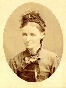
Photograph - Digital image, Sepia
Margaret Mary McSwain was born in Mordialloc in 1848, the daughter of Isabella Munro and Alexander Macdonald. Margaret died in Perth, Western Australia, in 1930.Sepia toned head and shoulders portrait of Margaret Mary McSwain. -
 Bendigo Historical Society Inc.
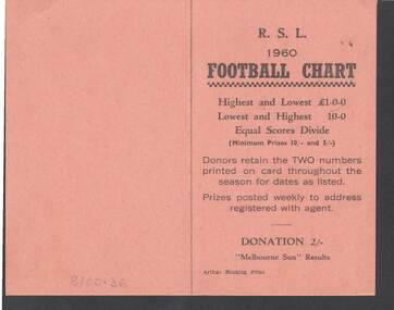
Document - R.S.L. BENDIGO COLLECTION: R.S.L. 1960 FOOTBALL CHART
Orange card titled R.S.L. 1960 Football Chart. On the front is how it works. Donation 2/-. Melbourne Sun Results. Printed by Arthur Hocking Print. On the other side is the list of the teams and the dates from 16/4/60 to 20/8/60. The Football clubs are: Melbourne, Sunshine, Geelong, Preston, Fitzroy, Box Hill, Richmond, Yarraville, South Melbourne, Oakleigh, St. Kilda, Brunswick, Hawthorn, Sandringham, Collingwood, Brighton, Footscray, Northcote, Moorabbin, Essendon, Coburg, North Melbourne, Camberwell, Carlton, Williamstown, Port Melbourne, Dandenong and Mordialloc.Arthyr Hocking Print.clubs and associations, football, football chart, r.s.l. bendigo collection - r.s.l. 1960 football chart, melbourne sun, arthur hocking print, melbourne, sunshine, geelong, preston, fitzroy, box hill, richmond, yarraville, south melbourne, oakleigh, st. kilda, brunswick, hawthorn, sandringham, collingwood, brighton, footscray, northcote, moorabbin, essendon, coburg, north melbourne, camberwell, carlton, williamstown, port melbourne, dandenong, mordialloc -
 Heidelberg Golf Club
Booklet, Golf Australia, Australian Amateur Championships 16-23 April 2011, 2011
Official guide to Australian Amateur Championships 16-23 April 2011. Played at Woodlands Golf Club (Mordialloc), Huntingdale Golf Club (South Oakleigh) and Victoria Golf Club (Cheltenham).Bruce Harding is a past HGC President and involved with Victoria's Junior teams, and as a rules official and referee.40p., illus. (some col.). Booklet accompanied by Conditions of competition and rules.bruce harding, australian amateur championships -
 City of Moorabbin Historical Society (Operating the Box Cottage Museum)
Flyer - Smith's Estate, Highett
The train line from the city to Mordialloc was built which opened up the land for housing development. The section bounded by Peterson Street Telford Street and Highett Road is now Peterson Street Reserve.Example of the progress of the Municipality of MoorabbinAdvertising flyer for auction of real estate sales - plan of building blocks for saleSmith's Estate, Highett - J. F. Bradyhighett, real estate, highett road, hillside street (no longer exists), peterson st, frederico st, tolhurst st (no longer exists), wickham road, danson street, peterson street reserve -
 Melbourne Tram Museum
Pamphlet, Yarra Trams, "Tram and Bus connections just got smarter", 2008
Pamphlet - two fold DL full colour printed on semi gloss paper, titled ""Tram and Bus connections just got smarter", introducing Smart Bus route 903 from Mordialloc to Altona connecting with 9 different bus routes. Gives details of the smart bus system, its route, timetable information and has a map of the route on the rear. Dated 2008.trams, tramways, smart bus, buses, public transport, maps -
 St Kilda Historical Society
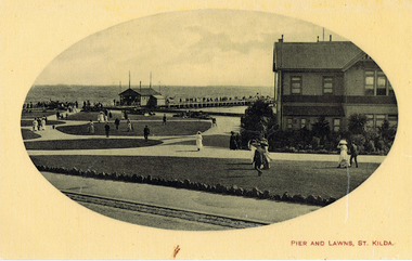
Photograph, J.A. Mackenzie, Pier and Lawns, St Kilda
sepia post card good conditionPier and Lawns St Kilda. hand written: Given to 'Historidal Society of St Kilda (stamped) by Mordialloc H Society 4/10/81. J.A. MacKenzie, Barkly st, St Kilda. Printed in Germany. H76. -
 Mordialloc College Alumni Association Inc (MCAA)
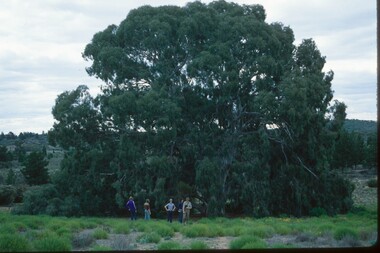
Photograph, 1979 Wyperfeld Old Be-al River Red Gum Tree, 1979
1979 - Mordialloc-Chelsea High School students standing in front of “Old Be-al” in Victoria’s Wyperfeld National Park, near Outlet Creek. It has been described as one of the most magnificent River Red Gums in the land. This glorious tree with foliage hanging to the ground escaped the fire of 1959 but not the fire of 1982 that damaged it badly. It lives on but has also suffered from lack of water and is now inaccessible to the public in a reference area. The MCAA has provided this image to the Friends of Wyperfeld National Park. Mordialloc-Chelsea High School students visited the Wyperfeld National park annually for the biology and geography Year 11 school camp.Example of a River Red Gum at Wyperfeld National Park.Digital image reproduced from colour slide.big desert fire 1959, mordialloc-chelsea high school camp, wyperfeld national park, fire 1982, old be-al river red gum -
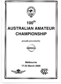 Heidelberg Golf Club
Booklet, Golf Australia, 100th Australian Amateur Championship, Melbourne 17-23 April 2005, 2005
Official guide to 100th Australian Amateur Championship, Melbourne 17-23 April 2005. Played at Woodlands Golf Club (Mordialloc) and Royal Melbourne Golf Club (Black Rock). Bruce Harding was a member of the Committee of the Victorian Golf Association during this competition.Bruce Harding is a past HGC President and was involved with Victoria's junior teams, and as a rules official and referee.28p., illus. (some col.). Handwritten draw for each round written in booklet.bruce harding, australian amateur championships -
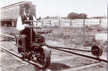 Chelsea & District Historical Society Inc
Photograph - Mordialloc Railway Station, Mr Pain, Railway Ganger, late 1860's
Black and white photo of a railway ganger, Mr Price, riding a railway tricycle at Mentone Station. In the background are a "Swing Door" carriage and in the distance two houses.mordialloc, railway, railway ganger, railway tricycle, tait carriages -
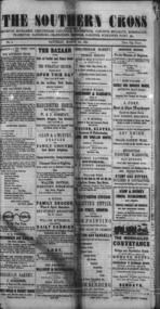 City of Kingston
Newspaper, John Stott, Southern Cross, 03 March 1871
The Southern Cross newspaper was produced in Brighton to be distributed in Brighton, Moorabbin, Cheltenham, Caulfield, Elsternwick, Oakleigh, Mulgrave, Mordialloc, Frankson, Dandenong, Cranbourne, and surrounding areas. The first issue was published on Saturday 25 February 1871. This is the second issue of the newspaper dated 03 March 1871.Black text printed on to white paper, covering four pages of typeset material. Each page has a combination of story and advertising.newspaper, brighton, advertising, community -
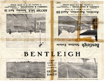 City of Moorabbin Historical Society (Operating the Box Cottage Museum)
Flyer - Bentleigh Station Estate Auction, Coghill & Haughton - W.H. Wood, Bentleigh, c1914
One of the first sales in the district since the land boom which began in 1881when the train line to Mordialloc was built. The land boom came to a halt in the 1890's due to the depression. This sale was also successful as the electrification of the train line from the city to Frankston had been announced.Example of the progress of the Municipality of Moorabbin.Advertising flyer for auction of real estate sales - plan of building blocks for sale - pictures of local area50 Choice Building Blocks adjoining Bentleigh Railway Stationcentre road, mavho street, loranne street, burgess street, bentleigh, bentleigh railway station, real estate, auctions -
 City of Moorabbin Historical Society (Operating the Box Cottage Museum)
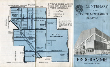
Pamphlet - Centenary of the City of Moorabbin 1862 - 1962, Programme April28 - May16, 1962, 1962
In 1962 the City of Moorabbin celebrated one hundred years of self local-government. The celebrations commemorated those who helped form the City of Moorabbin and to recognise their achievements. In May 1862 the Moorabbin district, which included Sandringham, Mentone and Mordialloc was made a Road Board District, on 27 January 1871 it was made a shire and then on 29 November 1934 Moorabbin was proclaimed a City. On 15 December 1994, the City of Moorabbin was abolished, and was split three ways; Bentleigh was transferred into the newly created City of Glen Eira along with the City of Caulfield; Cheltenham was transferred to the newly created City of Bayside, along with the Cities of Brighton and Sandringham; while the bulk of the city merged with the Cities of Mordialloc, Chelsea and parts of Springvale, to become the newly created City of Kingston.A souvenir of the celebration of 100 years of self government by theearly settlers from Moorabbin Roads Board 1862 until City of Moorabbin 1934-62 A tri-fold pamphlet colour print on outside and black and white inside. List of Councillors of City of Moorabbin 1961-1962 - Programme of all the events held to celebrate the Centenary of the City of Moorabbin from April 28 - May 16, 1962Centenary /of the / City of Moorabbin / 1862 -1962city of moorabbin, centenary, celebrations, floats, parade -
 Vision Australia
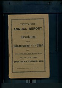
Administrative record - Text, Twenty First Annual Report of the Association for the Advancement of the Blind 1916, 1916
Annual report of the Association for the Advancement of the Blind outlined activities and events over the year, including the continuance of the concert parties, a trial massage course was held with two students graduating, the loss of Mrs Grimwade who was a Patron of the Association, and thanks to the Automobile Club residents took a road trip to Mordialloc for some afternoon tea.1 volume of printed material with some illustrationsassociation for the advancement of the blind, annual reports -
 Eltham District Historical Society Inc
Document - Folder, Murphy, James and descendants
James Murphy was a mining surveyor involved with the Caledonia diggings. Contents Note from Ray Blake, 26 April 2000: Ms Murphy said her people had traditionally owned all of inner Melbourne, north to the Great Divide, West to Werribee River, East to Mt Baw Baw, South to Mordialloc Creek.Newspaper clippings, A4 photocopies, etcjames murphy -
 City of Moorabbin Historical Society (Operating the Box Cottage Museum)
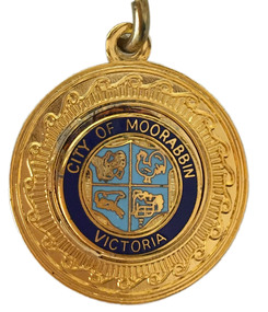
Badge - City of Moorabbin Key Chain
“City of Moorabbin” The township of Moorabbin, known as South Brighton until 1909, remained small, with the Plough and Harrow Hotel as its main building. In 1917 Sandringham borough was formed by severance from Moorabbin shire and in 1920 Mentone and Mordialloc were also severed. In the remaining Moorabbin shire the Moorabbin township was still small (1,770 persons), but the shire grew in population during the 1930s. On 10 October 1934 it was proclaimed a city. It existed as a separate municipality until 1995. When local government boundaries were changed in 1994 about half of Moorabbin city was united with Glen Eira city and about half with Kingston city. On 15 December, 1994 the City of Chelsea, parts of the Cities of Mordialloc, Moorabbin, Springvale and Oakleigh were amalgamated to create the City of Kingston by Order of the Governor in Council. On the same day Glen Eira City Council was formed from the City of Caulfield and the remaining part of the City of Moorabbin.Gold Key ring with a dark blue circle surrounding the shield of the City of Moorabbin.City of Moorabbin, Victoria,city of moorabbin -
 City of Moorabbin Historical Society (Operating the Box Cottage Museum)
Programme - Two Programs for Mayoral Functions held in the City of Moorabbin. 1946 & 1953, City of Moorabbin Council, 1946 & 1953
“City of Moorabbin” The township of Moorabbin, known as South Brighton until 1909, remained small, with the Plough and Harrow Hotel as its main building. In 1917 Sandringham borough was formed by severance from Moorabbin shire and in 1920 Mentone and Mordialloc were also severed. In the remaining Moorabbin shire the Moorabbin township was still small (1,770 persons), but the shire grew in population during the 1930s. On 10 October 1934 it was proclaimed a city. It existed as a separate municipality until 1995. When local government boundaries were changed in 1994 about half of Moorabbin city was united with Glen Eira city and about half with Kingston city. On 15 December, 1994 the City of Chelsea, parts of the Cities of Mordialloc, Moorabbin, Springvale and Oakleigh were amalgamated to create the City of Kingston by Order of the Governor in Council. On the same day Glen Eira City Council was formed from the City of Caulfield and the remaining part of the City of Moorabbin.Official functions held in the City of Moorabbin 1946 & 1953Two program cards, one green 1946 and the other cream 1953. The inside lists the entertainment during the reception of the Mayoral functions of the City of Moorabbina) RECEPTION /given by the / MAYOR AND MAYORESS / of MOORABBIN / 1946 b) RECEPTION / given by the / MAYORESS of MOORABBIN / 1953mcc, marriott, ward, coates, city of moorabbin, reception, program cards, entertainment, market gardeners, early settlers, cheltenham, moorabbin, bentleigh -
 City of Moorabbin Historical Society (Operating the Box Cottage Museum)
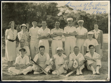
Photograph, Black & White, St Matthew's Church of England Cricket Team c 1940, c1940
The Cheltenham parish was created in 1865 by excising a portion of the parish of St Andrews Brighton. A small brick church was completed in 1867 to serve a rural community stretching from Brighton South (Moorabbin) to Mordialloc. 1867 St Matthew's Church of England was erected in Cheltenham beside the Nepean Highway near Charman Road. The early settlers established a tennis club, cricket team and social groups.St Matthew's Church of England Cheltenham was erected in 1867 and was integral to the spiritual well being and social life of the early settlers.Black & White photograph of the St Matthews Church of England Cricket team Cheltenham c 1940Front ; Church of England Cricket Team 1940 Back ; Written - Ladies / Hilda Biehl, Bertha Schneeberber, Mrs Wootton, / We made afternoon tea from / a kerosene tin for 30 players / each Saturday they played at home !!smith j l; smith mary ann, stanley helen, chaff cutter, horse drawn carts, toll gates brighton, motor cars 1900, steam engines, early settlers, bentleigh, parish of moorabbin, city of moorabbin, county of bourke, moorabbin roads board, shire of moorabbin, henry dendy's special survey 1841, were j.b.; bent thomas, o'shannassy john, king richard, charman s, highett william, ormond francis, maynard dennis, market gardeners, vineyards, orchards, -
Glen Eira Historical Society
Article - VICTORIAN RAILWAYS
File contains 3 items: 1/Original handwritten notes by Leo J Harrington (VR Melbourne) and T O’Callaghan titled ‘Victorian Railways to ‘62’. Notes include dates of electrification of lines, station openings, valuations, railway station names and their origins. Reference to council minutes regarding request to change the name of Elsternwick station to Caulfield in June 1871. 2/Original newspaper article from ‘The Age’ dated 10/06/1978 by Graeme Davidson titled ‘A case study of Railway politics’. Article refers to a publication called ‘Return to Rosstown, Railway, Land Sales and Sugar Beet ventures in Caulfield’ by D. F. ‘Return to Rosstown’ recounts the story of the Rosstown Junction railway and its creator, William Murray Ross. Tells of Ross’ life since coming to Australia from Liverpool and how he prospered as a land speculator owning large tracts of land in Caulfield, the sugar mill and his plans to operate a railway. 3/Original newspaper article (and image) from ‘Moorabbin Standard’ dated 25/11/1981, titled ‘Centenary train to carry mayors’. Article reports that a special train will run from Spencer Street Station to Mordialloc railway Station on Saturday 19/12/1981 to celebrate the centenary of the railway line to Mordialloc. Story mentions that in 1881, the Caulfield to Mordialloc line was a single track and that passengers can also board the special train at Caulfield Station. Image is of steam train with red ‘tait’ carriages (undated).victorian railways, caulfield, glenhuntly, glen huntly, elsternwick, carnegie, murrumbeena, ormond, steam train, glenhuntly road, glen huntly road, ripponlea, north road, rosstown, rosstown junction railway, ross william murray, railways, trains, south caulfield, grange road, railway stations, mirrambeena, caulfield city council, sugar mill, electrification. -
City of Kingston
Photograph - Colour, 1993
Carrum is a suburb in the City of Kingston bordered by the Patterson River in the north and Kananook Creek in the south. To the east the suburb is adjacent to Patterson Lakes. The Carrum Station was opened in 1882, when the railway line from Mordialloc was extended to Frankston. In the early 20th century, it was a destination for holidaymakers occupying tents and cabins. The area now consists of older housing and over time there have been many new housing developments.Carrum is located in the area that was originally part of the Carrum Carrum Swamp. The district had originally been the home of the Bunerong people who fished, gathered food and found refuge in the sand dunes. The Swamp was drained in 1879 when the Patterson Cut was formed and became known as Patterson River. Apart from local farmers, fishermen and hotel-keepers, there were few permanent residents until the early 20th century when it had become popular as a beach resort. In the 1920s and 1930s the area became occupied by more permanent residents.Laminated aerial colour photograph of Carrum and Patterson Lakes in the City of Kingston. The photograph also includes Kananook Creek and the northern section of Seaford. Prominent features include Roy Dore Reserve, Carrum Primary School, Patterson River Secondary College, Keast Park Seaford, the Seaford Swamp Drain and a section of Downs Estate situated on the traditional lands of the Bunurong people.Black type on white adhesive sticker: No. 7140 Black type of white adhesive sticker: 31-1-93 Black handwritten ink (marker): * [an asterisk] Yellow circular adhesive stickerpatterson lakes, seaford, carrum carrum swamp -
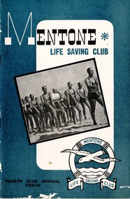 City of Kingston
Booklet, Mentone Life Saving Club: fourth club annual 1958-59, 1959
The Mentone Life Saving Club was formed in 1920 when the newly created City of Mordialloc (now the Kingston City Council) donated two bathing boxes to the newly formed Mentone Swimming and Life Saving Club on the site to the south of the former Mentone Pier. The Life Saving Club raised funds to build a new Clubhouse on the site and this was officially opened in December 1928 with the first Carnival Day of January 1929.The booklet contains black and white photographs of members and officials of the club. Each page is sponsored by a local business and provides a business record of the district as well as a social insight of activities of the citizens of Mentone and district.Booklet describing the club's activities during 1958-1959. Includes text and photographs, awards, honours, stories of personalities.lifesaving clubs, mentone life saving club -
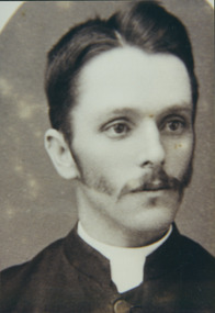 Uniting Church Archives - Synod of Victoria
Photograph, Rev. Charles Angwin, Late 19th C
B. 1860 Victoria; d. 1948 Burwood Victoria. Methodist minister, ordained 1886. Served at Dromana 1886; Poowong 1887; Wodonga 1888; Preston 1889; Donald 1890; Casterton & Coleraine 1893; Wangaratta 1895; Euroa 1898; Pyramid Hill 1901; Forth 1904; Latrobe 1908; Avoca 1911; Beeac 1914; Kilmore 1917; Frankston 1920; Mordialloc 1923; Superintendent Gardiner 1926. (No further records.).Photo of a young man with long sideburns and moustache, wearing a clerical collar and suit."Rev. Charles Angwin"angwin, charles -
Vision Australia
Audio (item) - Sound recording, Royal Victorian Institute for the Blind, Around the Institute: July 11, 2000
Around the Institute was a weekly program designed to keep clients and staff informed of events, activities and thoughts relating to low vision and blindness. It consisted of interviews undertaken by Jo Matthews, with sound engineer Ed Gamble, designed to inform, educate and explore on a variety of topics. July 11: CERA study Smoking and age related macular degeneration – Cathy McCarty, Mentone Mordialloc auxiliary 70th birthday – Barbara Pound and Vivian Talbot. royal victorian institute for the blind, radio shows -
 Phillip Island and District Historical Society Inc.
Document, Documents relating to the re-enactment of the 1869 coach run from Melbourne to Cowes via Hastings in 1985, 1985
1985 was the 150 anniversary of Victoria. Moorabin, Mordialloc, Sandringham and Phillip Island Councils organised a Cavalcade of Transport which included a re-enactment of a mail coach ride from Melbourne to Phillip Island in 1869. This trip was by Mr Ray Tovell at the invitation of William Harbison to stay with him at Phillip Island. Citizens were to dress in period costume and each municipality was to hand a letter containing local information to the coach driver along the route..Historical8 pages of typed letters and documents explaining the reasons for and details of the occasion. Also a history of the original trip.150 anniversary of victoria, transport, horse drawn coaches, stan gates, william harbison, local government -
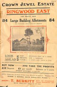 Ringwood and District Historical Society
Flyer, Subdivisional Land Sale Brochure, Crown Jewel Estate, Ringwood East, Vic. - c.1925
In May 1884, George Smart of Bulleen Road Kew, brickmaker, bought the 23 acres one rood and twenty nine and three tenths perches, or 9.4834 hctares from Arthur Bailey Clements of Ringwood for the sum of 600 pound sterling. (Extract from The Story of the Crown Jewel Estate in Ringwood East pdf)Double sided folded page with black and red print on both sides advertising auction sale of residential and business sites and highlighting local facilities, services and layout of the estate.Subdivision includes Mount Dandenong Road, Valda Avenue, Evon Avenue, Mirabel Avenue, and Velma Grove. (Agent) T. Burkitt, Box 12 Ringwood, Phone Ringwood 157. Vendor: A. Marshall Miller, McDonald Street, Mordialloc. Solicitors: Russell, Bona and Russell, 19 Queen Street Melbourne, and Ringwood - Phone Cent. 4308. -
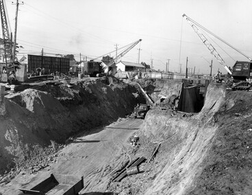 City of Kingston
Photograph - Black and white, c. 1958
Moorabbin station sits on the Frankston line which first opened in 1882 when the line was extended from Mordialloc. Moorabbin station opened in 1881 and was originally called South Brighton station. It was renamed Moorabbin station in 1907. In 1958 the station was relocated below street level which coincided with other construction works on Nepean Highway and South Road. This image is part of a larger collection of images from the Public Transport Corporation displaying train stations and streetscapes in what is now the City of Kingston.Black and white photograph showing excavations for Moorabbin station to be moved below street level. Stamped in blue ink on reverse: COPYRIGHT / Public Transport Corporation / For re-ordering photographs / Please quote negative No M6004 / Enquiries C/- PTC Photographic Unit / Telephone switchboard 619 111moorabbin, railway station, construction works, suburbs, nepean highway -
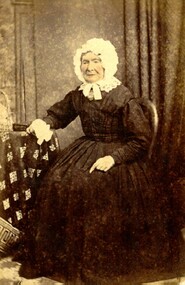 City of Kingston
Photograph - Digital image, Colour
Mary Munro was the mother of Isabella Munro. They travelled to Australia together aboard the Glen Huntley, although Mary travelled using her maiden name of McKenzie. They arrived in Port Phillip District in 1840. After an arduous crossing, they were required to go into quarantine at Point Ormond on arrival as the ship had several outbreaks of infectious diseases and arrived flying the yellow quarantine flag. She died in 1882 at 'Wattle Grove', Mordialloc. Isabella went on to marry Alexander Macdonald.Hand tinted colour image of Mary Munro, nee McKenzie, wearing black dress and a white bonnet, tied at the chin. -
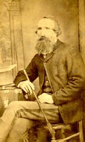 City of Kingston
Photograph - Digital image, Sepia
Born in 1817 to Murdo Macdonald and Flora Morrision at Bracadale near Sleat on the Isle of Skye in Scotland, Alexander Macdonald sailed on the Earl Durham to Sydney where he arrived on 2 January 1839. He was 21 years of age. After only a few months in the new country he set out overland for Melbourne where he joined his brother on a sheep run. He also became involved with his brother in conducting the Travellers’ Rest a stopping place for travellers at the Mordialloc Creek. Alexander married Isabella Munroe at Scots Church, Melbourne on 17 February 1841. After their marriage they started the sheep run named Stringy Bark, on the Yarra, near where Kew is today. Together, they had ten children. On the morning of 20 December 1881, Alexander’s hat was found floating in Mordialloc Creek. He had last been seen crossing the bridge the previous evening at ten o’clock. A few days later the body was later found only yards from the Bridge Hotel. A magisterial enquiry conducted by Thomas Attenborough concluded Alexander Macdonald’s death was an accidental drowning.Sepia toned image of Alexander Vause Macdonald (1817-1881). -
 Kiewa Valley Historical Society
Book - Book - Novel - Kiewa Adventure by Allan Aldous x2, Kiewa Adventure by Allan Aldous
An adventure novel of 192 pages set in the Kiewa Valley. Allan Aldous also has also written a series of McGowan Books set in different parts of the world.This book is set in the Kiewa Valley in Victoria where a Mr. Shapley finds new employment on the huge hydro-electric project. Hard cover red book with coloured paper dust jacket that has the title in red at the top and the author's name at the bottom left corner. The coloured picture is of 3 skiers and an aeroplane in the mountains. First Australian Edition 1950Inside on front page a certificate has been pasted on: "Presbyterian Church / of Victoria and Tasmania / League of / Young Worshippers / 'Mordialloc' Church / Awarded to / 'Robert Firth' / for attending '47' Sundays / at Church during the Year. / 'Rev. L Hercot' Minister The second book has "To Mark / Wishing you a Happy/ Birthday / Best Wishes from/ Trevor and Kevin / 19th March 1954"kiewa adventure, allan aldous author -
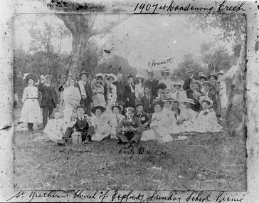 City of Moorabbin Historical Society (Operating the Box Cottage Museum)
Photograph - St Matthew's Church of England Sunday School Picnic 1907, 1907
The Anglican Cheltenham parish was created in 1865 by excising a portion of the parish of St Andrews Brighton. A small brick church was completed in 1867 to serve a rural community stretching from Brighton South (Moorabbin) to Mordialloc. 1867 St Matthew's Church of England was erected in Cheltenham beside the Nepean Highway near Charman Road. The early settlers established a tennis club, cricket team and social groups. A typical social event was the annual Sunday School Picnic held in 1907 at Dandenong Creek.Young members are mentioned Curly Owen,C,Burnett,A Manett St Matthew's Church of England Cheltenham was erected in 1867 and was integral to the spiritual well being and social life of the early settlers.Black & White photograph of the St Matthew's Church of England Sunday School Picnic 1907Handwritten Curly Owen, C, Burnett, A Manett st. matthew's church of england cheltenham, sunday school picnics, anglican church, st andrew's church brighton, owen curly, burnett c . manett a, horse drawn carts, toll gates brighton, motor cars 1900, steam engines, early settlers, bentleigh, parish of moorabbin, city of moorabbin, county of bourke, moorabbin roads board, shire of moorabbin, henry dendy's special survey 1841, were j.b., bent thomas, o'shannassy john, king richard, charman stephen, highett william, ormond francis, maynard dennis, market gardeners, vineyards, orchards -
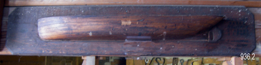 Flagstaff Hill Maritime Museum and Village
Craft - Ship Model, Peter Payne, Early 1930s to 1960s
Half-hull ship models were an important step in the process of building a vessel. Shipwrights or designers would construct a half-hull scale model of a ship before the vessel was built. They used it to ensure that the dimensions would work together and that the ship look balanced. They would often mount the half hull onto a board in their workshop. The half-hull ship models were also used to show prospective buyers how the design would work and look. Given the plywood construction of the model, it is believed to have been made around the 1930s as plywood construction had started in earnest in Queensland around this time and soon became the centre of the industry because of Queensland's attractive rain forest woods used which also included red cedar, silver ash, black bean, Queensland maple and silky oak. It is also believed the model was a design for a clinker-built barge to be built by Peter Payne who operated a boat building works on the Mordialloc Creek, Victoria going out of business in 1973. Records show Peter Paynes' first craft launched in 1962 and the last in 1973 from Mordialloc Creek works. However, he was one of the most prolific builders from the 1930s and produced many more vessels than the records currently show. There is at this point no further record of the subject model or whether a full version was ever built and for whom is not known at this time.A model that demonstrates the boat-building process is believed to have been made by Peter Payne or someone who worked in his yard. P Payne was a very well-known boating personality, vessel captain and boat builder throughout most of the 20th century. Model barge half hull on wooden of plywood laminated construction. Marked "AUXILIARY BARGE 80'x16'x6' 315 TONS 4" - 1 FOOT" "P and H PAYNE?" "22/E/26" flagstaff hill, warrnambool, flagstaff-hill, flagstaff-hill-maritime-museum, maritime-museum, shipwreck-coast, flagstaff-hill-maritime-village, ship model half hull, ship half model, shipbuilding, shipwright, ship design, peter payne, boat builder victoria, clinker design, barge