Showing 2027 items matching "planning document"
-
 Orbost & District Historical Society
documents, 26 January 1964
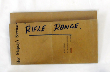
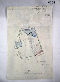
These documents were sent to Mr J. Ingram, 211 Nicholson Street, Orbost, Victoria from the Australian Rifle Club.A brown envelope containing two copies of a plan of the Orbost Rifle Range. There is also a memorandum of Agreement concerning the Orbost North Recreation Reserve. There is a letter from the Victorian Rifle association concerning the extension of the rifle range.orbost-rifle-club shooting rifle-range-orbost -
 Orbost & District Historical Society
book, Thematic Environmental History, 2001
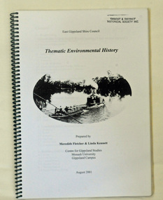
This booklet was prepared for the East Gippsland Shire Council in August 2001.A Thematic Environmental History identifies how key patterns of development have influenced the culture of the area and the natural and built environment. The document is not a social history but usually provides the context for future heritage studies and assessments and would provide input to the preparation of a Heritage Action Plan. This booklet prepared for the East Gippsland Shire councilA spiral bound book of 75 pp, titled Thematic Environmental History, prepared by Meredith Fletcher and Linda Kennett for the Centre for Gippsland Studies, Monash University, Gippsland Campus. On the front cover is a black and white drawing of a paddle steamer towing a barge along a river. It contains information on the discovery, settlement and land usage of East Gippsland as well as the development of transport, communication and cultural institutions. Copywright held by East Gippsland Shire Council and Department of Infrastructureenvironmental-study-east-gippsland -
 Ringwood and District Historical Society
Document - Folder, Commercial and Retail Property Sales Information, Civic Place and Melbourne Street, Ringwood - 1998
45 photocopied pages including - Plan of Subdivision No.LP80718, Parish of Ringwood, Victoria, Crown Portion 12(Part) and part of a former government road Ref Vol 8668 Fol 745. - Vendors Statement, Planning Certificate and Heritage Council (Victoria) Certificate issued for 20 Melbourne Street, Ringwood. - Maroondah City Council Land Information Certificate for 149 149A and 149B Maroondah Highway; number 8 Civic Mall; and numbers 16, 20, 22 & 24 Melbourne Street Mall. - Yarra Valley Water statements relating to encumbrances for Shop 11, 149 Maroondah Highway; Shop 10, 149A Maroondah Highway; Shop 9, 149B Maroondah Highway; numer 8 Civic Place; Unit 3, 20 Melbourne Street; Office 4, 20 Melbourne Street; Shop 7, 22 Melbourne Street; and Shop 8, 24 Melbourne Street. - Land Tax Certificate pertaining to Commonwealth Bank, Civic Place, Ringwood. - Certificate of Title Vol 8892 Fol 906, Lot One on Plan of Subdivision No. 80718, Parish of Ringwood - Hanover Developments P/L - 29th June, 1971. -
 Phillip Island and District Historical Society Inc.
Booklet, Official Opening of the Phillip Island Bridge at San Remo 1969 and notes by the Bridge engineer, Tom Russell, 1969
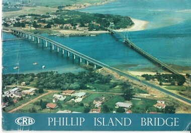
Prior to 1939 access to the Island was by punt from San Remo or car ferry from Stony Point. A bridge was opened in 1940 but increased traffic and low load capacity was a problem. The decision to build a new bridge was made in the 1960s.HistoricalColoured, bound booklet with a photo of the old and new Phillip Island bridges on the cover and the CRB logo and name on rear. It includes the order of proceedings for the opening and bridge statistics, plans and contractor information. Also photos of construction and a history of travel to the Island before a bridge was built and the first bridge. There is also a 2 page typed document written by the bridge engineer who gives a brief history of access to the Island and problems at the opening with access and a rebel who tried to open it unofficially.Official Opening of the Phillip Island Bridge at San Remo by The Hon. M.V. Porter, MLA. Minister of Public Works. November 21 1969bridges, 2nd phillip island bridge construction, tom russell, phillip island bridge opening 1969 -
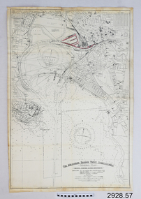 Flagstaff Hill Maritime Museum and Village
Document - Navigation Chart, The Melbourne Harbor Trust Commissioners
Navigation Chart - The Melbourne Harbor Trust Commissioners - General Plan - Shewing proposed Harbor Improvements. Hobson's Bay and Citywarrnambool, shipwrecked-coast, flagstaff-hill, flagstaff-hill-maritime-museum, maritime-museum, shipwreck-coast, flagstaff-hill-maritime-village, shipwrecked-artefact, navigation chart, hobson's bay, the melbourne harbor trust -
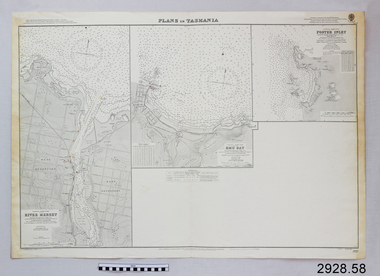 Flagstaff Hill Maritime Museum and Village
Document - Navigation Chart, Plans in Tasmania - Foster Inlet, River Mersey and Emu Bay
Navigation Chart - Plans in Tasmania - Foster Inlet, River Mersey and Emu Baywarrnambool, shipwrecked-coast, flagstaff-hill, flagstaff-hill-maritime-museum, maritime-museum, shipwreck-coast, flagstaff-hill-maritime-village, shipwrecked-artefact, river mersey, foster inlet, emu bay, navigation chart -
 Ringwood and District Historical Society
Plan, SGL Consulting Group Aust Pty, Maroondah Leisure Facilities Review / Strategic Plan 2010-2050, May-10
Prepared for the Maroondah City Council, Vol one - Executive Summary of the Maroondah Leisure Facilities Review Strategic Management Plan 2010-20508 A4 double sided printed documents with black and white photos, charts & text -
Ringwood and District Historical Society
Land titles and plan, Victorian Titles Office, Titles and plans of Ringwood Land between Mullum Land and Wonga Rd. (Re Ann Jane Kennedy). 1907, 1-Oct-07
The documents pertaining to Ann Jane Kennedy inheriting the land from her late husband Samuel John Kennedy and the history of the transfers of land from Ann Jane Kennedy in 1907 until the title was cancelled in 1925 to James Melbourne Ross. The area was 10 acres between Mullum Mullum Road and Wonga Road retrieved from Titles Office.Ten pages of photocopied titles and plans of land in Ringwood between Mullum Road and Wonga Road, also transfer of original land. -
Ringwood and District Historical Society
Collection of papers, Documents pertaining to the planning and implementation the Ringwood Methodist Day Kindergarten
... Documents pertaining to the planning and implementation... Council Documents pertaining to the planning and implementation ...Property of Ringwood Methodist Pre-School CouncilDocuments pertaining to the planning and implementation the Ringwood Methodist Day Kindergarten.They include 47 pages of advertisements, letters,draft constitution. All in a manila folder. +Additional Keywords: Bandt, Rev R MProperty of Ringwood Methodist Pre-School Council -
Ringwood and District Historical Society
Plastic packet, PTC - Maroondah City Council, Public Transport Commission, Ringwood Railway Station Development Study, Interchange Upgrade, Community Workshops - various printed documents 1995-2013, 1995 to 2013
The urban consulting group commissioned Maroondah City Council and the Public Transport Feasibility Study, Ringwood Railway Station to be upgraded October 1995Various printed documents relating to PTC (Public Transport Commission), Maroondah City Council, Department of Transport - Ringwood Railway Station Redevelopment Study October 1995, Ringwood Station Bus interchange upgrade, designing new look Ringwood Station. Workshops were held for the community. +Additional Keywords: Ringwood Station Bus Interchange upgrade feed back sheet October 2011 / Ringwood Station Precinct Redevelopment Workshop held 26 July 2011 / Ringwood Station and bus upgrade December 2011 / Ringwood Town Centre South Project / Precinct Plans Planning Report. / Ringwood Town Centre Draft Report November 2000 / Ringwood Activities Community Newsletter August 2011 - Ringwood Station Update / State Government to sell Central Ringwood Railway land - Herald Sun 30 December 2013 / Ringwood Town Centre Precinct 4 Station Superblock for Railway Station July 2009 / Media release $66m station 15 April 2015 / Ringwood Station and Interchange Upgrade, Wednesday 27 August 2014 / Lifts left off upgrade plan - Leader Community Paper, 10 December 2013 / How to submit your feedback - Ringwood Station Precinct proposed concept, December 2011 / Designing a new look Ringwood Station workshop handout / State Government announces $66 million redevelopment of Ringwood Train Station, Herald Sun 6 June 2013 / Ringwood Station and bus interchange upgrade project update July 2012 / Set Concept design plans of $66 million Ringwood Railway Station over the years / Set photos of Ringwood Station taken between 2004 to 2005 / A3 drawing - Plan of Ringwood Station / A3 drawing - Ringwood Station proposed layout / A3 drawing - Old Station, Ringwood / A3 drawing - Proposed plan 2011 / A4 drawing - Final plan of Ringwood Station 2014 / A4 drawing - Proposed plan 2010 Ringwood Railway Station / A3 drawing - Proposed plan Ringwood Station with bridge across Maroondah Highway -
 Bendigo Military Museum
Document - VIETNAM PAPERS - HERDMAN
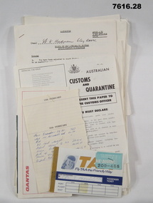
5. Pocketbook issued to Australian Troops during the Vietnam War. Contents include: The War in South Vietnam, The People, Government Services, Armed Services, Viet Cong, Vietnamese Language, Useful information. 14. Details of Australia V US. Hill climb with program of Events, 22nd February 1970. 15. Details of dog races with fields listed on a six race program - 20th February 1970. 18. Document details departure itinerary (ex SVN) for K.J. HERDMAN. 27. Notebook contains names and addresses of US service personnel. Papers related to "Kevin John Herdman's" visit to South Vietnam from 18th February to 4th March 1970. Part of the Kevin John Herdman, No. 397661 Collection. See Cat. No. 5942P for details of his service. 27. Collection of documents related to K.J. Herdman. 1. Two page TAA flight ticket. Text in blue coloured type. Two baggage tickets stapled to front. 2. Single diary page with torn edge. Handwritten flight itinerary in section dated 16th February. 3. Two page QANTAS flight ticket. Text in red and black type. Flight details printed in purple type. 4. Printed flier outlining Australian Customs and Quarantine regulations. Recipient's name handwritten in black ink. 5. Green coloured soft cover pocketbook. 74 pages with cut edges. Black and white diagrams. Text in black type. 6. Small pamphlet with black type. Written in Vietnamese. 7. Foolscap sized 5 page document stapled on top LHC. Text in black type. Title "VISITS BY CMF OFFICERS TO VIETNAM". 8. A4 sized one page document with text in black type on one side only. Two sided pamphlet on blue paper stapled to top LHC. Black type on pamphlet. Title "NINE RULES FOR AUSTRALIAN ARMY FORCES IN VIETNAM." 9. Two page A4 sized document with text in black type. Text on one side of each page. Title "AUSTRALIAN FORCE VIETNAM, RTA BRIEFING NOTES - QANTAS CHARTER, SAIGON/SYDNEY". 10. Foolscap signed proforma oriented in landscape. Title: AUSTRALIAN MILITARY FORCES, VISITS BY CMF OFFICERS TO SYN". Details of personnel in black type. 11. Quarto sized two page document with printing on one side. Text in black type. Staple in top LHC. Title: "CMF VISITOR - LT. K.J. HERDMAN, (ITINERARY FOR LT. K.J. HERDMAN)". 12. Quarto sized two page document with printing on one side. Text in black type. Staple in top LHC. Title: " CMF VISITOR - LT K.J. HERDMAN (ITINERARY FOR LT. K.J.HERDMAN)" 13. A4 sized document with text in black type. Text on one side only. Title: CMF VISITOR - LT. K.J. HERDMAN". 14. Foolscap sized document with text in black type. Printing on one side. Title: "LONG HI HILL CLIMB". 15. Quarto sized document with text in black type. Printing on one side. Title: "DAT DO DOGS". 16. Foolscap sized 9 page document with text on one side. Printing in black type. Pages stapled together in top LHC. Title: "1 ATF G INSTRUCTIONS 14/69, SUPPLIES, POL AND AMMUNITION HOLDINGS". 17. A4 sized document with text on one side. Printing in black type. TITLE; "AMENDMENT 1 TO Q INSTRUCTION 14/69, DATED 23 OCT 69". 18. A4 SIZED DOCUMENT WITH TEXT ON BOTH SIDES. PRINTING IN BLACK TYPE. 19. Foolscap sized 3 page document with staple in top LHC. Text on page 1 in black type. Text on pages 2 & 3 in purple type. Pages are entitled "TEMA FLYING PROGRAMME - CH 47". 20. Foolscap sized 7 page document with text in black type. Printing on one side. Title: " OPERATIONS BREF - DET 52 SUP PL RAASC, REPUBLIC SOUTH VIETNAM (1967-69)", Dated 20 Sept, 69. 21. Foolscap sized 2 page document with text in black type. Printing on one side. Pages stapled on top LHC. Title: " Q INSTRUCTION 15/69, RETURN OF PRODUCE, " Dated 16 Oct 69. 22. Foolscap sized single page document with text in black type. Printing on one side. Title: " Q INSTRUCTION 19/69, RETURN AND DISPOSAL OF UNSERVICEABLE AMMUNITION" Dated 5 Nov 69. 23. Foolscap sized single page proforma with text and lines in black. No handwritten details. Title: "26 TRANSPORT COY RAASC VEHICLE SERVICEABILITY/AVAILABILITY STATE". 24. Foolscap sized single page proforma with text and lines in black. No handwritten details. Title: "DAILY EMPLOYMENT STATE, 85 TPT PL RAASC". 25. Foolscap sized single page document. Text and lines in purple. Reproduced on a spirit duplicator. Title: "INDENTING PROGRAMME FRESH". 26. Foolscap sized single sheet proforma with text and lines in black. No handwritten details. Title: DAILY MAINT MOVEMENT PLANNING TABLE". Printing on both sides. 27. Red and white covered note book. Title on front and details on back in black type. Lined pages. Handwritten information on most pages. 28. Illustrated Christmas Card. Illustration features an angel and the three Magi. Printing on inside in black. Handwritten message in black ink. 1. Passenger details handwritten in blue, carbon copy. 2. Itinerary notes handwritten in blue ink. 3. Handwritten in black ink: "CAPT K.J. HERDMAN". Flight details printed in purple coloured text. 4. Handwritten in black ink : "KEVIN JOHN HERDMAN". 7. Handwritten in black ink on page 1: LT. K. HERDMAN, 6 Coy RAASC, 17 Feb 70." Handwritten in black ink on last page: "1. Ensure teeth are all O.K., 2. Have you still got your tags Identity? (Signature). 11. Handwritten on top RHC of page 1: "CAPT A". 12. Handwritten on top RHC of page 1: "LT HERDMAN". 27. Handwritten notes in black ink on various pages. 28. Handwritten in black ink on inside of card: "Hello Kevin, Perhaps you remember the 62nd Trans. Company at Long Bing? I completely enjoyed your brief stay. If you are ever in the U.S. do stop by. Have a Merry Christmas to you and yours. Margo and Jack Olsen." vietnam war, army, training notes, kevin john herdman -
 Bendigo Military Museum
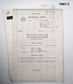
Document - DOCUMENTS - MISCELLANEOUS - ARMY, Australian Army
1. Minutes of the first meeting of the RACT A-RES Corps Planning Committee held at the RACT Centre, Puckapunyal at 1400 hrs 26 Jun 1977. 2. Provision of self drive vehicles, Army Reserve Staff. 3. Physical Training tests (PTT) ARES. Part of the "Kevin John Herdman" No. 397661 Collection. See Cat 5942P for details of his service. Three Australian Army photocopied documents on A4 paper. Each document's pages are stapled on top LHC. Text in black type. Australian Army letterhead on top of first page of each document. Printing on one side of each page.1. Handwritten in blue ink on page 1: "Maj Herdman". 3. Handwritten in blue ink on page 1: "MAJ K. HERDMAN"ract, vehicles, army, physical training, kevin john herdman -
 Bendigo Military Museum
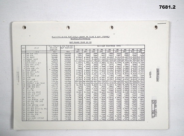
Document - PLANNING GUIDE, SUPPLIES, ARMY
... . Document PLANNING GUIDE, SUPPLIES, ARMY ...1. & 2. Tabulated planning guides for daily use of Class 3, Sup (Tonne). Part of the "Kevin John Herdman" No. 397661, collection. See catalogue No. 5942P.1. & 2. Quarto sized multi page documents with pages stapled in top LHC. Holes punched on LHS for placement in a ring binder. printing on one side of each page in black.kevin john herdman, army, planning guide, supplies -
 Bendigo Military Museum
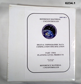
Manual - Digital Topographic Data Compilation Specification - Part 2 Planning Level Products, June 1998
The purpose of this document is to provide digital Topographic data compilation specifications for the Australian Defence Force (ADF) which are applicable to all areas of the Area of Direct Military Interest (ADMI) for the collection of features and attributes to populate the ADF topographic database.6234.1 A four ringed Folder containing A4 Paper, White, Metal Bindings, Chapters 1 to 8 6234.2 A four ringed Folder containing A4 Paper, White, Metal Bindings, Chapters 8 to 13 and Annexesroyal australian survey corps, rasvy, fortuna, army survey regiment, army svy regt, asr, director of survey - army -
 Bendigo Military Museum
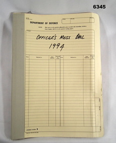
Administrative record - Army Survey Regiment Officers Mess Ball 1994, Army Survey Regiment, Bendigo, February 1994
The Army Survey Regiment held Annual Balls at Fortuna Villa. This folder contains the documentation for the Logistics and activities associated with the planning and running of the Officers Mess Ball held in 1994.Cloth bound manilla Correspondence File containing A4 paper documentsroyal australian survey corps, rasvy, fortuna, army survey regiment, army svy regt, asr -
 Bendigo Military Museum
Document - RENOVATION SPECIFICATIONS BRSL, C. 1962 onwards
These renovations were first discussed by the Bendigo RSL in 1962 - 1963. This Document is headed, “Specifications of Workmanship and Materials required for Painting and Renovations etc, at R.S.S.A.I.L.A Hall, Pall Mall, Bendigo” There are 3 parts to the documents. First section has 22 parts, everything from “Tender - Insurance - Materials - Liability - Condition of Contract to the use of Sanitary conveniences. Second section has sections re “Carpenter and Joiner - Brick work - Plastering - Electrician - Painter and Glazier”. Each has sections under re their work to be done. Third section is a technical drawing of the Soldiers Memorial Institute minus the Main Hall, it shows scopes of work. The main works covered a new false ceiling in the Office, a new front door entrance to the Foyer in a different position, exhaust fan in the Billiard room, removal of a gate at the Stairwell entrance, fire place repairs, adding chair rails to walls to foyer, Committee room. These works were carried out. There was a false ceiling in the Meeting room but there was no mention re this in the above plans. This ceiling was removed during the 2016 - 2018 major renovations to the SMI. The false ceiling in the Office was removed in a major renovation to the room in 2011 - 2012 and taken back to original.Folder brown card covers with six typed in black pages and one map all black print, pages stapled in with 2 binder holes in.On front cover in black pen. "Specifications - Painting & Renovations R.S.L. Premises Pall Mall, Bendigo"brsl, renovations, smirsl -
 Bendigo Military Museum
Plan - Victorian Titles Office - Fortuna Lot Plan, Victorian Titles Office, 3 Dec 1975
Title plan of Fortuna property depicting the initial acquisition in 1951 plus additional areas acquired during 1955 and 1957. The accompanying notes show details of the acquisitions, when they occurred and the costs. The plan is foolscap in size whilst the Notes are a single smaller sheet. Includes one foolscap size page, probably part of a larger (more page) document.Title plan of Fortuna property depicting the initial acquisition in 1951 plus additional areas acquired during 1955 and 1957. The accompanying notes show details of the acquisitions, when they occurred and the costs. The plan is foolscap in size whilst the Notes are a single smaller sheet.Top right hand corner - "Certificate of Title entered in the Register Book Vol. 8159 Fol. 690, Signature Illegible, Assistant Registrar of Titles". Towards the bottom right hand corner - "No ENDOURSEMENTS (some unreadable Signatures) H.D. Draper 24.11.75, R.B? 26.11.75, ? 3.12.75. Near bottom of Page - Initials?" "THE MEASUREMENTS ARE IN LINKS"royal australian survey corps, rasvy, fortuna, army survey regiment, army svy regt, asr -
 Warrnambool and District Historical Society Inc.
Documents, Swintons Paper att 18/53 Merri St. Contract. Map. Notes, 1959
These documents relate to the sale of land in Merri Street Warrnambool in 1959 by Swintons Pty Ltd of Warrnambool. The buyer of the land was George O’Grady, a Warrnambool baker. The land sold for £4000 and there was a shed on the land (called the ‘Office’) which George O’Grady indicated he wished to be included in the sale. William and Ann Swinton migrated to Australia in 1854 and for a decade William Swinton worked as a builder and carpenter in the Warrnambool area, erecting many buildings, including the Wangoom Presbyterian Church. In 1865 he opened a store in Timor Street Warrnambool, selling groceries, hardware, china and glassware. By 1888 the business was known as William Swinton and Sons. Branch stores were opened in Wangoom, Cudgee, Nullawarre, South Warrnambool and West Warrnambool. After William Swinton died his son Robert became the first managing director of Swintons Pty Ltd. In 1934 the business split with George Swinton and Sons selling clothing, furnishings and glassware and Swintons Pty Ltd selling seeds, produce and hardware. Today the Swinton family still operates a furniture and bedding shop in Timor St Warrnambool.These items are of some interest as being connected to the Warrnambool business of Swintons Pty Ltd. They will be of interest to researchers. The current Swinton business in Timor Street is the oldest family business in Warrnambool and, with the name Swinton associated with businesses in Timor Street Warrnambool for 152 years it is amongst the oldest family businesses in Australia.The items here relate to the sale of land by Swintons Pty Ltd., Warrnambool. .1 These are three pages of white paper with typed material, a lawyer’s signature in blue ink, one green stamp and a sketch of the land location. .2 This is a sheet of thick paper containing a plan of the land sold. The paper has printed material and a sketch of the land with part of it coloured in pink. .3 This is a small piece of paper torn at the bottom right edge. It has handwritten material (a letter) in blue ink..2 ‘Plan of Survey of Part of Crown Allotment 18 Section 3 Township of .2 ‘Plan of Survey of Part of Crown Allotment 18 Section 3 Township of Warrnambool Parish of Wangoom County of Villiers’ .3 ‘Tuesday Dear Mr Swinton I am writing to say that I would like to have the ‘Office’ Thanking You George O’Grady’swinton family,, warrnambool -
 Warrnambool and District Historical Society Inc.
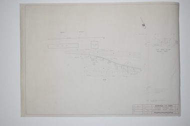
Documents, WCC Proposed turntable site railway station, 1968; 1989
These two plans are copies and show drawings for a proposed turntable at the Warrnambool Railway Station and railway crossings at Gilles Street in the Liebig Street precinct. The Warrnambool Railway was opened in 1890 and the Warrnambool Railway Station building was erected a few years later. These plans, being copies, are of minor interest as they show plans of some projects in the Warrnambool Railway Station precinct in the latter half of the 20th century.These are two sheets of cream-coloured paper with plans (copies of original) drawn up in black ink. The drawings are fading somewhat and are faint in places. One sheet (.2) has a piece missing from the top left hand corner. .1 ‘Locality Plan of Rail Crossings Liebig St. & Gillies (sic) St.’ .2 ‘Proposed Turntable Site Warrnambool Railway Station’ plans, warrnambool railway, warrnambool rail turntable -
 Warrnambool and District Historical Society Inc.
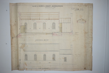
Document, Plan of Church of Christ Warrnambool, 1883
These plans have been drawn up in 1883 by the Warrnambool architect, William Patterson. They show six sections of plans for the erection of a Church of Christ at 12 Spence Street Warrnambool. The mason was William Kellas and the builder was Harold Dawkins. Church of Christ adherents began meeting in Warrnambool in 1875 and bought land in Spence Street in 1877. The church was opened in 1885 with visiting pastors until a resident minister, A. J. Fisher, was appointed in 1915. This church was closed early in the 21st century when a new church, Gateway Church of Christ, was opened in Ragland Parade in Warrnambool. These plans are of great interest as original ones of the Church of Christ In Spence Street Warrnambool. The plans have come from the present-day Warrnambool Church of Christ. The building still exists but is no longer is use as a church. These are two sheets of cream-coloured thick paper with scaled drawings of plan sections of the Church of Christ in Warrnambool. The drawings are in black ink with some sections coloured in. Both pages have a black line margin drawn around the edges. The pages are torn at the edges in several places and the sheets are much stained. The sheets have been reinforced at the back (left side) with thick brown paper.‘Plan of Christ Church Warrnambool’plans church of christ warrnambool, william kellas, harold dawkins warrnambool -
 Kiewa Valley Historical Society
Papers - History of Mt Beauty Football Club 1974
Ian McKendrick was secretary of the Mt Beauty Football Club on 8th Aug. 1974. He compiled important papers re the club's history and stored them in an envelope for future reference and preservation with the idea of each secretary passing the envelope on to the next secretary.Mt Beauty football club was formed at a meeting on 19th Sept. 1974 attended by Bogong Tawonga Football club when the club changed its name. The Mt Beauty football club has since amalgamated with the Dederang football club. List of footballers in 1975 is helpful for researching local families living in the Kiewa Valley. An envelope titled 'Notice to Secretary' and 'List of Documents'. Enclosed 15 pages comprising of 1. Newspaper cuttings, 2.Typed pages with the title - 'Recreation Reserve pavilion - Mt Beauty', 3. Typed page title 'Mt Beauty Recreation Reserve Drainage', 4. Plan of Mt Beauty Recreation Reserve pavilion sketch 1975, 5. Handwrittten page title re P. O'Brien Years of Association 1950 - 1974 and names of teams on the back.. There is more than one copy of some pages. 1970smt beauty football club, ian mckendrick, bogong tawonga football club -
 Kiewa Valley Historical Society
Evacuation Plans for children during WWII, 1941
During World War 2 the State Emergency Council for Civil Defence (Victoria) sent out forms to Municipal Councils requesting a survey to be carried out regarding the suitability of householders to accommodate persons, especially children, in the more dangerous parts of Victoria. Also, surveying parents as to their wishes regarding the evacuation of their own children if necessary. The documents list householders living in the Kiewa Valley including Gundowring giving an insight into the families (size, age, religion, sex), the homes (size, number and type of rooms), Water supply, Conveyance (motor or horse drawn), distance from railway station and school. Papers created by the State Emergency Council for Civil Defence, Premier's Department 1941 requesting Municipal Councils to survey people in case of the billeting of persons who may be evacuated from the more dangerous parts of Victoria. The Accommodation Survey lists the householder, details of the house, how many people living there and how many could be accommodated.There are also forms asking householders if they wish their children to be evacuated if necessary.Forms filled out in ink. world war ii; evacuation plans; kiewa valley; gundowring -
 Warrnambool and District Historical Society Inc.
Document, Ticket Warrnambool Botanic Gardens Night in the Gardens, 2016
This card is an invitation to attend a Night in the Gardens in March 2016 to celebrate the 150th Anniversary of the Warrnambool Botanic Gardens. The first site of the Warrnambool Botanic Gardens was near the mouth of the Hopkins River but this site proved unsuitable and a new location ( the present location) was found in 1866 bounded by Cockman Street and Botanic Road. In 1877 William Guilfoyle was commissioned to provide a new plan for the Gardens. An important curator was Charles Scoborio ( 1872 to 1906 ) This card is of minor interest as a memento of the celebrations in 2016 to celebrate the 150th anniversary of the Warrnambool Botanic Gardens A black rectangular card with white text.Night in The Gardens warrnambool botanic gardens, charles scoborio -
 Warrnambool and District Historical Society Inc.
Document, Sticker Warrnambool Botanic Gardens 150 years A Growing Legacy, 2016
This sticker was issued to celebrate the 150th anniversary of the Warrnambool Botanic Gardens. These Gardens were first established in the early 1850s on a site near the mouth of the Hopkins River but this site proved unsuitable and the Gardens were moved to the present location (Cockman Street/ Botanic Road) in 1866. In 1877 William Guilfoyle was commissioned to provide a plan for the Botanic Gardens . A prominent curator was Charles Scoborio 1872 to 1906. This sticker is a minor interest as a memento of the 150th anniversary in 2016 of the Warrnambool Botanic Gardens A white sheet of paper containing a circular shaped sticker with blue print and a logo in green and purple. The printing is in black and purple.Warrnambool Botanic Gardens 150 years A GROWING LEGACYwarrnambool botanic gardens, william guilfoyle -
 Warrnambool and District Historical Society Inc.
Document, Wristband Night in the Gardens, 2016
This wrist band was issued to those attending a Night in the Gardens, an event held in 2016 to celebrate the 150th Anniversary of the Warrnambool Botanic Gardens. These Gardens were first established near the mouth of the Hopkins River in the 1850s but this site proved unsuitable and they were moved to the present location ( Cockman Street/ Botanic Road) in 1866. In 1877 William Guilfoyle was commissioned to provide a plan of the Gardens. Charles Scoborio 1872 to 1906 was a prominent curator. A piece of paper with black printing and removable ends with adhesive on the back to form a temporary wrist band. Night in the Gardens 19th march 2016- 7 pm.william guilfoyle, charles scoborio -
 Warrnambool and District Historical Society Inc.
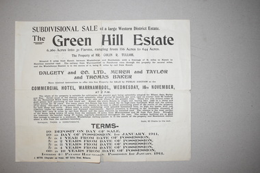
Documents (2), 1 1915 .1 1910
These documents come from a collection of material from the Baulch families of Dunmore and Rose Park estates in Western Victoria in the Macarthur district. They concern the sales of the Green Hills Estate (1910) and the Olangolah estate (1915) near Woolsthorpe. Both were offered for sale by the owner, Colin Tulloh. The properties bordered on Baulch property belonging to Stan Baulch (1897-1980) and hence this is the reason for their being included in Baulch estate material. These items are of minor interest and will be useful to researchers as they show the sizes and some owners of some early 20th century Western District properties. .1 A single sheet of white paper with a map or plan of a property and black printing. The paper is creased and torn slightly at the edges. 2 A single sheet of white paper with a map of a property on one side and black printing on the other. The paper is creased and torn at the edges. The Green Hills Estate Western District Estate ‘Olangolah’ western district estates, warrnambool, olongolah estate, green hills estate -
 Warrnambool and District Historical Society Inc.
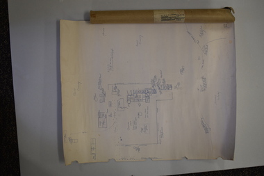
Document (Sketch Plan of Dunmore), Stan Baulch, 1972
... Document (Sketch Plan of Dunmore)... and the cover have handwritten titles in ink. Document (Sketch Plan ...This card has a sketch map showing the properties surrounding Dunmore on one side and a detailed sketch plan of Dunmore homestead in the early 1970s on the other side. The plan of Dunmore homestead shows interesting features such as the brick oven for bread making, the croquet lawn, the site of the aboriginal mia mias, the Turkish baths and the fowl house used later as a poison house. Francis and Ann Baulch were pioneer settlers in the Kirkstall area and their son Samuel worked at Dunmore in the Macarthur area before purchasing in the early 1870s the property he named Rose Park. In the 1890s he acquired property in the Dunmore estate and his son Stan Baulch gained a section of the Dunmore property after his father’s death. Stan Baulch named this Dunmore section, Rose Park, a property to the west of his father’s original Rose Park property. Stan Baulch was a long time member of the Warrnambool & District Historical Society and he contributed many local history articles and donated many local artefacts to the Society.This sketch plan is of interest as it tells us what the historic homestead of Dunmore in Western Victoria was like in the early 1970s. It will be useful for research. This is a sheet of white lightweight cardboard with a pencilled sketch on one side and a blue ink sketch plan of a house on the other side. The edges of the card have some torn sections. The card is enclosed in an oval cardboard cylinder (recycled and torn at the ends). Both the card and the cover have handwritten titles in ink. Dunmore Homestead & History by S. Baulch Dunmore Homestead drawn by Stan Baulch c.1972 dunmore property, western victoria, baulch family -
 Warrnambool and District Historical Society Inc.
Original Document, Map: Agricultural area of Ballangeich 1865, 1865
George Eddington arrived in Australia in 1839 and named and established property in 1841 calling the property Ballangeich after a Pass near his home town of Stirling in Scotland. It is situated 151 miles west of Melbourne and to the south of Mortlake and was originally part of the Mortlake shire, which was proclaimed 26th Jan 1864. Nearest streams are the Hopkins Riverand Lyall and Drysdale creek running through good agricultural land. This map relates to the breaking up of large runs which the Victorian government enabled through selection acts of the 1860's. The previously larger runs which were mainly cattle and sheep based were now more open to closer settlement and a greater variety in farming.The lots range in size from approximately 50 acres to around 600 acres.Some areas are set aside for reserves. By 1886 the population of Ballangeich had grown to around 600 with an hotel, three state schools and a church.Tri weekly coaches ran to Colac, Warrnambool and Camperdown providing access to supplies mail and communication. This map is typical of many which were produced in the 1860's in Victoria during a significant period of Victoria's and Warrnambool district history.Rectangular light card paper with black text showing allotments of land The area is coloured in green with scale at bottom right cornerAt the top: Plan of the Agricultural area of Ballangeich 1865 At the bottom left: Prepared by the Board of Lands & Works in accordance with the Amending Land Act 1865 Lands & Survey Office Melbourne 13th April 1865. With signaturehistory of warrnambool, ballangeich, land surveys victoria 1865, lands act 1865 victoria, ballangeich map 1865 -
 Eltham District Historical Society Inc
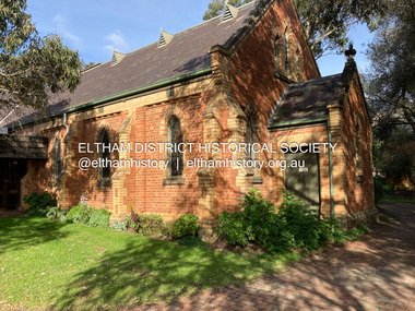
Photograph, Jim Connor, Eltham - Montmorency Uniting Church, 810 Main Rd, Eltham, 10 July 2023
Located on the corner of Main Road and John Street, the church first served the community as the Eltham Wesleyan Church since 1881. It became the Eltham Methodist Church in 1902, the year it united with the Primitive Methodists. Eltham Wesleyans first worshipped together in the home of William and Mary Crozier, on 24 acres bounded by Mount Pleasant Road and Pitt Street. From there they moved to a slab and bark hut in 1855 (this later served as the first school run by David Clark prior to the building of a new school in Dalton Street) and the members then built a chapel in 1858 on Lot 20, Henry Street (later to become the Rechabite Hall and Eltham Public Hall). The present church on John Street was designed by architects Crouch and Wilson in the Early English Gothic style with biochrome brick window frames, buttress heads and pinnacle. Church member George Stebbing built the church, the foundations were constructed with stone from the walls of the first Eltham State Primary School (No. 209) building which collapsed in 1874 and were purchased by Robert David Taylor. Stebbing was also responsible for building St Margaret’s Church and Shillinglaw Cottage. The Roll of Honour, which presently hangs in the church hall (which also doubles as the Opportunity Shop) lists 27 members of the congregation who served in the First World War, 11 of whom never returned. The red-brick Church Hall was opened in 1931 and in 1971 further additions linked the hall and church, including a foyer, vestry, meeting room and toilets reflecting the Eltham style of that time with its simplicity, extensive clear glass, reused baked clay-bricks from the 1881 church, heavy ceiling beams and compressed straw ceiling. On June 26, 1977, the church became part of the new Uniting Church in Australia consisting of the former Methodist and Congregational and most of the Presbyterian Churches. Following of declining numbers of worshippers, the church merged with the Montmorency Uniting Church on June 23, 1996. In 2023 the Uniting church approved a plan to renovate the church. It is understood that the historic church and the hall will be retained, and the building added in 1971 is to be demolished, to make way for a new purpose-built Opportunity shop. The proposed areas to be demolished include the current foyer, toilets, crèche, etc, including the area between the hall and the former RSL. Works are expected to commence mid to late July 2023. The Society was invited by a church member to take photographs of these areas to document them prior to demolition works commencing. Ref: “Nillumbik Now and Then” by Marguerite Marshall (2008)jim connor collection, 2023-07-10, eltham-montmorency uniting church, john street, methodist church, opportunity shop, uniting church, uniting church hall -
 Eltham District Historical Society Inc
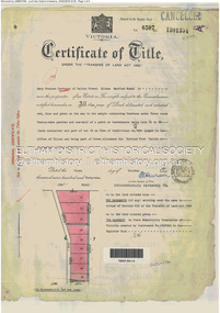
Document - Property Binder, 60 Kent Hughes Road, Eltham
1. Certificate of Title of Lot 22 on Plan of Subdivision No. 7894 and other material pertaining to Mary Frances Carrucan (nee Sweeney) and family connections (Digital file only)eltham, 60 kent hughes road, certificate of title, mary frances carrucan (nee sweeney)