Showing 328 items
matching private residence
-
 Wodonga & District Historical Society Inc
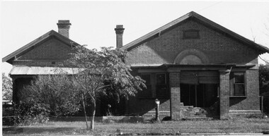
Photograph - Codling Collection 01 - Wodonga's First Court House
... it was replaced in 1920. It was then used as a private residence for many.... It was then used as a private residence for many years. At various stages ...Miss Olive Codling was a Foundation Member and a Life Member of the Wodonga Historical Society. Many of her prize-winning photos are held in the Society Collection. She also held a range of roles and committee positions in a wide range of Wodonga community organisations. COURT HOUSE - Wodonga's first court house was a timber building constructed in 1859. In January 1877, a contract was let to add the brick building to the existing structure. This court house opened in June 1877. This gabled court house was designed by architect Peter Kerr and was constructed at a cost of £1,325. It served as the court house until it was replaced in 1920. It was then used as a private residence for many years. At various stages it was also operated as a restaurant, a real estate agency, an antique shop and currently operates as commercial offices.This photo collection is significant as it documents how the businesses and buildings in Wodonga have evolved and contributed to community throughout the 20th century.A black and white image of the original Court House and Police paddock. Also an image of the "Court" sign, a view of the back of the building and a present day colour image of the building.wodonga businesses, high st wodonga, wodonga court house -
 Linton and District Historical Society Inc
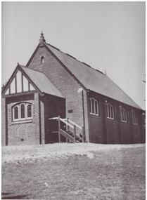
Photograph, Methodist Church, Grantley Street, Linton
... and became a private residence about 1979.... and became a private residence about 1979. Methodist Church Linton ...Methodist Church meetings and services are known to have been held in tents on the Lintons diggings from the late 1850s. A small wooden church was built in in 1858-59 in Sussex Street, Linton (near where Shepherd's store was located). Sunday School meetings began there in November 1859. By 1860 the church building was considered too small. The land was sold to Mr. Brewer, and the building was removed to a site in Grantley Street and enlarged. Shortly after this, it was decided to build a new church, a wooden structure which was opened in 1861. This building was still in use at the time of the Methodist Church Jubilee in 1910, however around 1905 a fund was established to build a new brick church (pictured), which was opened in 1913. This building was sold and became a private residence about 1979.Black and white photograph of brick church building, leadlight windows in three sections at front and alongside. Sets of steps leading to doors on both sides of church front entrance porch.methodist church linton -
 Linton and District Historical Society Inc
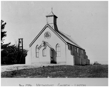
Photograph, Methodist Church, Linton, Timber Construction, Opened 1861
... building was sold and became a private residence about 1979.... building was sold and became a private residence about 1979 ...Methodist Church meetings and services are known to have been held in tents on the Lintons diggings from the late 1850s. A small wooden church was built in in 1858-59 in Sussex Street, Linton (near where Shepherd's store was located). Sunday School meetings began there in November 1859. By 1860 the church building was considered too small. The land was sold to Mr. Brewer, and the building was removed to a site in Grantley Street and enlarged. Shortly after this, it was decided to build a new church, also of timber construction, which was opened in 1861. This building (pictured) was still in use at the time of the Methodist Church Jubilee in 1910, however around 1905 a fund was established to build a new brick church which was opened in 1913. This brick building was sold and became a private residence about 1979.Black and white photograph which has been printed as a post card. The photograph shows a timber church which has a kind of turret, and side buttresses. Bell tower on left of picture. Large lamp hanging from entrance porch.methodist church linton, postcards -
 Linton and District Historical Society Inc
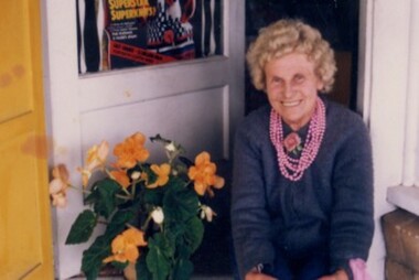
Photograph, Carrie Murrell outside Murrell's Newsagency, Linton
... . It is now used as a private residence. Carrie Murrell died in 1998..... It is now used as a private residence. Carrie Murrell died in 1998 ...Carrie Rogers Murrell, b.1905 at Daylesford, was a daughter of William Murrell and his wife Lily, née Clarke/Young. She was a grand-daughter of Ambrose and Mary Murrell. Carrie Murrell attended Linton State School, completing Grade 8 in 1n 1918. She then assisted her father in the Linton newsagency, before taking over as its manager, a role she enjoyed for some seventy years. In 1932 she moved the business from its site on the west side of Sussex Street to the east side, into a shop next to the Railway Hotel that had previously been run as a shoe shop by Dan Cornish. This shop remained as the Linton Newsagency until Carrie retired. It is now used as a private residence. Carrie Murrell died in 1998.Colour photo of Murrell's Newsagency, Miss Murrell seated in front doorway.carrie murrell, linton newsagency -
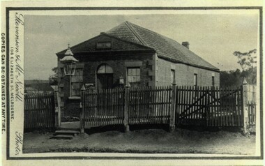 Bacchus Marsh & District Historical Society
Photograph, Old Mechanics Institute Young Street, Bacchus Marsh 1883
... was purchased by Thomas Anderson and for some years was a private... was purchased by Thomas Anderson and for some years was a private ...A Mechanics Institute in Bacchus Marsh dates from sometime in the 1850s. The foundation stone for this hall dates from 1858. The hall was located on the corner of Young Street and Bennett Street on land donated by James Young. In 1883 a new and larger Mechanics Institute Hall was built in Main Street. The old hall was purchased by Thomas Anderson and for some years was a private residence. It was later bought by the Royal Antediluvian Order of Buffaloes (RAOB) and became a Lodge for that order. In its later years it was known locally as 'The Buff's Hall'. It was eventually demolished in the late 20th century. Built in Young Street on land owned by James Young, a prominent citizen of Bacchus Marsh, this Hall was the venue for the commencement of the political campaign of Alfred Deakin, and later for the campaign of Peter Lalor, a leader of the Eureka Rebellion.Small sepia 'carte de viste' style unframed photograph on card with gold border framing photograph. Housed in the Jeremeas Family Album which contains photographs of Bacchus Marsh and District in 1883 by the photographers Stevenson and McNicoll. The photo is of a single-storey brick building. The front has a gabled entrance with a central doorway and two windows, one on either side of the door. A plaque has been inset in the gable above the door. The hip roof is shingled. Three windows run along the side of the building. A picket fence on very uneven footage runs along the front. The entrance gateway has two steps up to the entry and is decorated with an ornate lantern supported by a slim metal framework. Another lantern is fixed to the left of the front door.Printed On the front: Stevenson & McNicoll. Photo. 108 Elizabeth St. Melbourne. COPIES CAN BE OBTAINED AT ANY TIME. On the back: LIGHT & TRUTH inscribed on a banner surmounted by a representation of the rising sun. Copies of this Portrait can be had at any time by sending the Name and Post Office Money Order or Stamps for the amount of order to STEVENSON & McNICOLL LATE BENSON & STEVENSON, Photographers. 108 Elizabeth Street, MELBOURNE. stevenson and mcnicoll 1883 photographs of bacchus marsh and district, mechanics institutes, halls, bacchus marsh mechanics institute -
 Eltham District Historical Society Inc
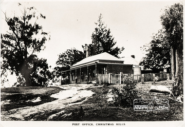
Photograph, Post Office, Christmas Hills
... to the residence next door (to the east) which took over the role... to the residence next door (to the east) which took over the role ...The site of the Post office was the south side of Eltham on the Yarra Glen road. 0.3 km SW of Ridge Rd., now freehold. The first Post Office-cum General Store at Christmas Hills was built by Thomas Young during the 1870s, when the district was a thriving farming community. Young operated postal services here from 1874 to 1909. Moreover, the two front rooms of this general store aslo served as the district's first school. When the store was demolished in the early 1900s, these school-rooms were moved to the residence next door (to the east) which took over the role of the Post Office store until the service finally closed in the early 1970s. The latter building is still in use today as a private residence". Christmas Hills Past & Present (Yarra Glen & District Historical Society, 2004)Roll of medium format 120 6x6 black and white negative film, 4 framesAgfa APX 100shire of eltham pioneers photograph collection, sepp, christmas hills, post office -
 Tarnagulla History Archive
Photograph of stables behind bank building, Tarnagulla, Stables behind bank building, Tarnagulla, circa late 1960s
... . It is now a private residence. ... the 1990s. It is now a private residence. tarnagulla banks banking ...Murray Comrie Collection. This image depicts the stables at rear of a two-storey bank building in Tarnagulla. The bank building was used first by the Colonial Bank of Australasia (from 1866 to 1888) and then by the Union Bank (from 1888 to 1942). The two-storey bank building was built in 1866 by the Colonial Bank of Australasia. Before this, the site had been occupied by Foo's shop. Whilst it was being built, the Colonial Bank operated from Company's Hotel (later known as Burstall Hall and the Council Chambers). The new double-storey building was used by the Colonial Bank from 1866 until 21st February, 1888. The premises were sold to the Union Bank for £2500. The Union Bank moved in and commenced operations on 6th June 1888, continuing until 1942. The building was later used as a general store until the 1990s. It is now a private residence. Monochrome photograph depicting stables at rear of the double-storey bank building in Tarnagulla. Image depicts a brick building with white timber doors and corrugated metal roof. The site was originally built by and for the Colonial Bank and later used by the Union Bank. tarnagulla, banks, banking, commerce, buildings, commercial road, horses, stables -
 The Beechworth Burke Museum
Postcard
... . The building at rear in this photograph was the private residence.... The building at rear in this photograph was the private residence ...This Australian yesteryear postcard was published by Cobb & Co in circa 1990. It is a sepia toned artwork of the Ann Jones Inn in Glenrowan which was taken prior to 1880. The building at rear in this photograph was the private residence of Ann Jones, a migrant from Tipperary, Ireland. Two years after building her private residence, in 1878/1879, Ann Jones added the Inn to the front of the building which is depicted in the postcard. In 1880 the Inn was burned to the ground during the Kelly Gang siege. After the siege, Ann Jones and her children continued to live on the same location in a makeshift hut. This hut was later replaced with a dwelling using compensation money provided to Ann from the government for the loss of her property and goods; however, she was denied a new trading licence which did not enable her to re-establish her previously successful business. The reverse of this postcard provides a snippet of information into the Glenrowan siege, for which this site is most well-known. It outlines the role and demise of the members of the Kelly Gang but what it does not include is how Ann Jones, owner of the Inn depicted on the postcard, was impacted. Ann’s son of 13 years, Johnny was killed during the siege, and a bullet grazed the forehead of her daughter, Jane Jones. Jane would die two years after this event from tuberculosis, but it was believed by Ann that the cause was grief for the death of her brother and distress at having witnessed the siege. Ann was provided with 100 pounds in compensation money for the loss of her children. Her husband, Owen Jones passed away late 1880 and in 1891 Ann Jones remarried. She died at the age of 80 in 1910. The “last stand” of the Kelly Gang at this location is estimated by Dr Stuart Dawson of Monash University to have taken less than 10 minutes in duration. During and following this time, the life of Ann Jones was turned upside down and everything she had worked for in the preceding years was now in ruins. This postcard has the capacity to reveal information about the popularity of the Kelly story in Australia. It was created in approximately the 1990s which perhaps reveals a resurgence in interest into the Kelly Gang and Australian history when card was made. This image, and others depicting the Ann Jone’s Inn, have the ability to shed light on the Kelly story and the events of the Glenrowan Siege. Additionally, they can reveal information into the life of a female business owner during the 1870-1880 period. Archaeological research has been conducted at this site by LaTrobe University and a study of these images alongside the analysis of the material culture found at this location can help to build more comprehensive understanding into life in Australia during this period and Ann Jones herself.Sepia rectangular postcard printed on cardObverse: [Illegible] Reverse: G4/ 3276/ Australian / Yesteryear / cards/ correspondence / address / Published by Cobb & Co (03) 5766 2409 / The Glenrowan Inn owned by Ann Jones. / It was this Inn in which the Kelly Gang imprisoned / 62 people, while waiting for the special train / carrying the police to arrive from Benalla. On 28th / June 1880, following a seige which lasted over 12 / hours, Ned Kelly was captured. Joe Byrne was shot, / and the Inn was set on fire in an attempt to flush out / the two remaining outlaws, Dan Kelly and Steve / Hart. However, some time prior, the two boys, it / was believed, had committed suicide, as a result, / their bodies were incinerated beyond recognition. / A sepia tone facsimile of / an early Australian photograph. /kelly album, postcard, glenrowan inn, kelly siege, australia yesteryear card, cobb & co publisher, ned kelly capture, jones ann, dan kelly, joe byrne, steve hart, fire, train, police, benalla, 28 june 1880 -
 Tarnagulla History Archive
Photograph of stables behind bank building, Tarnagulla, Stables behind bank building, Tarnagulla, circa 1970s
... . It is now a private residence. This is a reasonable copy... the 1990s. It is now a private residence. This is a reasonable ...Murray Comrie Collection. This image depicts the stables at rear of a two-storey bank building in Tarnagulla. The bank building was used first by the Colonial Bank of Australasia (from 1866 to 1888) and then by the Union Bank (from 1888 to 1942). The two-storey bank building was built in 1866 by the Colonial Bank of Australasia. Before this, the site had been occupied by Foo's shop. Whilst it was being built, the Colonial Bank operated from Company's Hotel (later known as Burstall Hall and the Council Chambers). The new double-storey building was used by the Colonial Bank from 1866 until 21st February, 1888. The premises were sold to the Union Bank for £2500. The Union Bank moved in and commenced operations on 6th June 1888, continuing until 1942. The building was later used as a general store until the 1990s. It is now a private residence. This is a reasonable copy of an older original. Copy probably made by Murray Comrie in the 1970s. Monochrome photograph depicting stables at rear of the double-storey bank building in Tarnagulla. Image depicts a brick building with white timber doors and corrugated metal roof. The site was originally built by and for the Colonial Bank and later used by the Union Bank. tarnagulla, banks, banking, commerce, buildings, commercial road, horses, stables -
 Tarnagulla History Archive
Photograph of former bank building being used as general store, Tarnagulla, Former bank building being used as general store, Tarnagulla, circa late 1960s
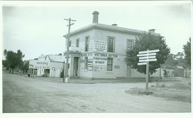
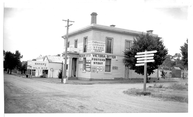
... . It is a now private residence. Probably taken by Murray Comrie... the 1990s. It is a now private residence. Probably taken ...Murray Comrie Collection. This image depicts stores in the main street of Tarnagulla, including the two-storey bank building being used as a licensed general store. The bank building was used first by the Colonial Bank of Australasia (from 1866 to 1888) and then by the Union Bank (from 1888 to 1942). The two-storey bank building was built in 1866 by the Colonial Bank of Australasia. Before this, the site had been occupied by Foo's shop. Whilst it was being built, the Colonial Bank operated from Company's Hotel (later known as Burstall Hall and the Council Chambers). The new double-storey building was used by the Colonial Bank from 1866 until 21st February, 1888. The premises were sold to the Union Bank for £2500. The Union Bank moved in and commenced operations on 6th June 1888, continuing until 1942. The building was later used as a general store until the 1990s. It is a now private residence. Probably taken by Murray Comrie in the late 1960s. Monochrome photograph depicting a section of Commercial Road, Tarnagulla at the intersection with Poverty Street, including two stores - one a bakery/milk-bar and the other a general store operating in the former Bank building. tarnagulla, banks, banking, commerce, stores, shopping, shops, food, groceries, buildings, commercial road -
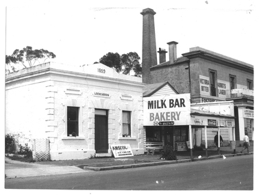
 Tarnagulla History Archive
Photograph of former bank building being used as general store, Tarnagulla, Former bank building being used as general store, Tarnagulla, circa 1960s-70s
... . It is a now private residence. This is a reasonable copy... the 1990s. It is a now private residence. This is a reasonable ...Murray Comrie Collection. This image depicts stores in the main street of Tarnagulla, including the two-storey bank building being used as a licensed general store. The bank building was used first by the Colonial Bank of Australasia (from 1866 to 1888) and then by the Union Bank (from 1888 to 1942). The two-storey bank building was built in 1866 by the Colonial Bank of Australasia. Before this, the site had been occupied by Foo's shop. Whilst it was being built, the Colonial Bank operated from Company's Hotel (later known as Burstall Hall and the Council Chambers). The new double-storey building was used by the Colonial Bank from 1866 until 21st February, 1888. The premises were sold to the Union Bank for £2500. The Union Bank moved in and commenced operations on 6th June 1888, continuing until 1942. The building was later used as a general store until the 1990s. It is a now private residence. This is a reasonable copy of an older original. Copy probably made by Murray Comrie in the 1970s. Monochrome photograph depicting a section of Commercial Road, Tarnagulla at the intersection with Poverty Street, including two stores - one a bakery/milk-bar and the other a general store operating in the former Bank building. The general store was operated at this time by James Buchanan. tarnagulla, banks, banking, commerce, stores, shopping, shops, food, groceries, buildings, commercial road -
 Melton City Libraries
Photograph, Burning Off, Unknown
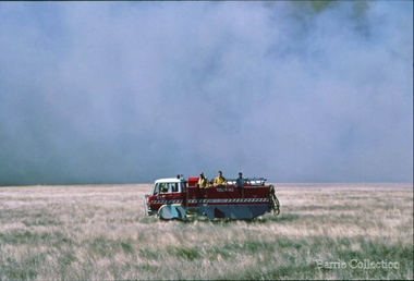
... in private residences and operated primarily by fire fighters wives... in private residences and operated primarily by fire fighters wives ...Many of the brigade and group base radios were situated in private residences and operated primarily by fire fighters wives who held the position of Communications Officer, either registered as a brigade member or informally. Edna Barrie was never registered as an operational brigade member but operated informally as an assistant to her husband Bon. She was however a member of the Melton Fire Brigade Ladies Auxiliary from its inception in 1968, a non-operational position. Edna kept up to date with radio procedure following the 1967 handbook; preparing maps, plotting compass points and taking notes on weather forecasts from the SA Border and Western District. Daily notes were taken in anticipation of fire warnings. These log books and daily radio traffic were incidental to the regular radio schedules. Emergency turnouts noted, burning off times and predicted location of smoke. In the summer fire season all TBF (total fire ban days were recorded.)CFA burning off dry grassemergency services -
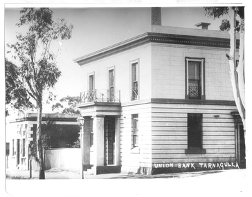
 Tarnagulla History Archive
Photograph of bank buildings, Tarnagulla, Bank buildings, Tarnagulla, circa 1866 to 1888
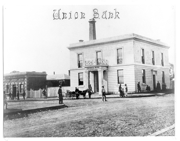
... buildings are now private residences. This is a reasonable copy... until the 1990s. Both buildings are now private residences ...Murray Comrie Collection. There were four banks in Tarnagulla at one stage, but two - the National Bank and the Bank of Australasia - were open for a short period only. The single-storey brick building at far left was built in 1859 and used by the Union Bank until 1888, and was later renamed 'Lochcarron' and used as premises by doctors and dentists. The two-storey building (right) was built in 1866 by the Colonial Bank of Australasia. Before this, the site had been occupied by Foo's shop. Whilst it was being built, the Colonial Bank operated from Company's Hotel (later known as Burstall Hall and the Council Chambers). The double-storey building in this image was used by the Colonial Bank from 1866 until 21st February, 1888. The premises were sold to the Union Bank for £2500. The Union Bank moved in and commenced operations on 6th June 1888, continuing until 1942. The building was later used as a general store until the 1990s. Both buildings are now private residences. This is a reasonable copy of an older original. Copy probably made by Murray Comrie in the 1970s. Monochrome photograph depicting a section of Commercial Road in Tarnagulla with two brick buildings, one single-storey and one double-storey. A horse-drawn carriage is standing out side the larger building. A number of men, women and children are standing or walking alongside the buildings and in the street. Caption on original 'Union Bank'.tarnagulla, banks, banking, commerce, buildings, commercial road -
 Tarnagulla History Archive
Photograph of bank buildings, Tarnagulla, Bank buildings, Tarnagulla, circa 1866 to 1888
... buildings are now private residences. This is a reasonable copy... until the 1990s. Both buildings are now private residences ...Murray Comrie Collection. There were four banks in Tarnagulla at one stage, but two - the National Bank and the Bank of Australasia - were open for a short period only. The single-storey brick building at far left was built in 1859 and used by the Union Bank until 1888, and was later renamed 'Lochcarron' and used as premises by doctors and dentists. The two-storey building (right) was built in 1866 by the Colonial Bank of Australasia. Before this, the site had been occupied by Foo's shop. Whilst it was being built, the Colonial Bank operated from Company's Hotel (later known as Burstall Hall and the Council Chambers). The double-storey building in this image was used by the Colonial Bank from 1866 until 21st February, 1888. The premises were sold to the Union Bank for £2500. The Union Bank moved in and commenced operations on 6th June 1888, continuing until 1942. The building was later used as a general store until the 1990s. Both buildings are now private residences. This is a reasonable copy of an older original. Copy probably made by Murray Comrie in the 1970s. Monochrome photograph depicting a section of Commercial Road in Tarnagulla with two brick buildings, one single-storey and one double-storey. Caption on original in right lower corner 'Union Bank Tarnagulla'. Handwritten on reverse: Orig showed building to left of Lochcarron H. Joyce Fruiterer' and 'Orig with Mr. A.M. Renshaw'.tarnagulla, banks, banking, commerce, buildings, commercial road -
 Kew Historical Society Inc
Photograph - 'Carronbank', Marshall Avenue, 1980s
... a private residence until c.1960. The Department of Education... a tennis court at the rear of the property. It remained a private ...Carronbank (demolished) in Marshall Avenue, Kew was once the home of the Rev Graham Henty Balfour. It had extensive grounds, including a tennis court at the rear of the property. It remained a private residence until c.1960. The Department of Education purchased Carronbank as a school for partially sighted children, opening in February 1961 as State School No 4483. During the period 1961 to c.1980, the building housed a number of services. From 1969 to 1974, it was the site of Carronbank State School, later renamed Carronbank School for Deaf-Blind Children. In 1973, the Department established the Visiting Teacher Service for the Visually Impaired at the site. Its aim was to support teachers working in Victorian Government, Catholic and Independent Schools. From 1983 the school operated as Statewide Resource Centre for Visiting Teachers of the Vision Impaired. In 1988, the amalgamation of Princess Elizabeth Junior School for Deaf Children, the Monnington Centre and Carronbank School for Deaf Blind Students allowed the Victorian Government to sell each of the sites. Monnington [Adeney Avenue, Kew] reverted to private ownership, while Glendonald and Carronbank in Marshall Avenue were demolished and subdivided.The donor, Mr Murray Osler, was Principal of the Monnington Special Education Centre in Adeney Avenue (Kew) from 1976. This photo, and an accompanying drawing of 'Monnington' are important primary resources for the delivery of education to and for deaf-blind children in Victoria.The photograph, framed under perspex, shows the tennis court of Carronbank which had been converted into a play area for the students of the school. The flat roofed building may have been a toilet block, added for the school. The garage brick wall belongs to No 11. Grass is growing on the original asphalt court and there is equipment and tunnels for play. When sold the property was divided into three separate building blocks.carronbank -- marshall avenue -- kew (vic.), schools -- kew (vic.), carronbank -
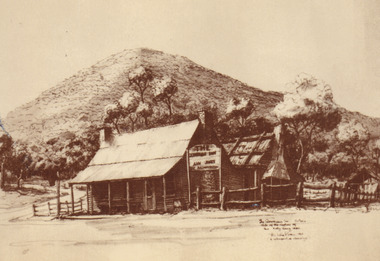
 Eltham District Historical Society Inc
Photograph - Digital Photograph, Alan King, Wellers Restaurant, 150 Eltham-Yarra Glen Road, Kangaroo Ground, 23 January 2008
... and converted to a private residence. Around 1920 William Pitman bought... and converted to a private residence. Around 1920 William Pitman bought ...Originally Wellers Hotel, it was constructed by Edward Weller in 1872. Following his death in 1883 it was taken over by his widow, Mary Weller. The hotel was delicensed in 1909 and converted to a private residence. Around 1920 William Pitman bought the property, succeeded by his son Vernon who coined the term Pittman's Corner. Vernon and Isabel Pitman owned the house form 1945-1973. Following Vernon's death, Isabel remained there till her death in 1983. The property was converted to a restaurant in 1984 by owners Robert and Kath Hendry who undertook extensive renovations in 1988. Shawn and Stephanie Wolfe purchased the property from the Hendrys in 2003 and introduced live entertainment with many famous bands and entertainers from the 1960s, 1970s and 1980s performing there, including James Reyne, Daryl Barithwaite, Brian Cadd and Billy Thorpe. In 2014 the Wolfe's sold the property and the entire contents were sold at auction. New (local ) owners Gregory Anderson, Craig Jones and Steve Gist refurbished the property and relaunched it as Fondata 1872 in 2017. Covered under Heritage Overlay, Nillumbik Planning Scheme. Published: Nillumbik Now and Then / Marguerite Marshall 2008; photographs Alan King with Marguerite Marshall.; p87This collection of almost 130 photos about places and people within the Shire of Nillumbik, an urban and rural municipality in Melbourne's north, contributes to an understanding of the history of the Shire. Published in 2008 immediately prior to the Black Saturday bushfires of February 7, 2009, it documents sites that were impacted, and in some cases destroyed by the fires. It includes photographs taken especially for the publication, creating a unique time capsule representing the Shire in the early 21st century. It remains the most recent comprehenesive publication devoted to the Shire's history connecting local residents to the past. nillumbik now and then (marshall-king) collection, eltham-yarra glen road, fondata 1872, kangaroo ground, wellers restaurant, billy thorpe, brian cadd, craig jones, daryl barithwaite, edward weller, gregory anderson, hotels, james reyne, kath hendry, mary weller, restaurants, robert hendry, shawn wolfe, stephanie wolfe, steve gist -
 Ballarat Heritage Services
Photograph - Image - Colour, Clare Gervasoni, Bishop's Palace Ballarat Featuring Chimneys and Roof Line, Ballarat, 2014, 23/02/2014
... lifetime, from the home of the first Bishop to a private residence... lifetime, from the home of the first Bishop to a private residence ...Bishops Palace was built in 1877 as the home for the first Catholic Bishop of Ballarat. Designed by Melbourne architect, Joseph Reed, of Reed and Barnes, it was built by George Broom at a cost of £6,000. Reed and Barnes also designed Melbourne’s State Library, Ripponlea Estate and the Melbourne Royal Exhibition Building. The original heritage-listed gold lead stencilled paintwork that can be seen in the front entry and on the staircase walls at Bishops Palace was replicated in the Royal Exhibition Building. The original property was 140 squares set on 11 acres of gardens and took up an entire block of Sturt Street. This was on scale with the importance of Ballarat as a gold-mining centre at the time. Bishop's Palace is of architectural, aesthetic and historical significance to the State of Victoria. The two-storey bluestone mansion is an impressive example of 19th-century Gothic architecture with an unusual design. It retains many of its original features, including lead stencilled paintwork, cornices, ceiling roses, fixtures and fittings. Since sold by the Catholic Church the Bishops Palace has undergone a number of transformations in its lifetime, from the home of the first Bishop to a private residence, and today, as a luxurious accommodation, wedding and events venue. The grounds were subdivided over the years, and the property is now surrounded by four of the original 11 acres of gardens. It opened its doors to the public in 2019.Colour image of the bluestone Bishop's Palace, and it's cast iron lace.architecture, garden, bishop's palace, cast iron lace, cast iron, catholic church -
 University of Melbourne, Burnley Campus Archives
Photograph - Colour print, Herb Garden, 1983
... The site of the former Principal's Residence private back...The site of the former Principal's Residence private back ...The site of the former Principal's Residence private back garden. The Herb Society of Victoria provided assistance with design in 1984 and Coora Cottage Herbs donated plants. Memorial birdbath and fountain donated by the Herb Society of Victoria and the family of the late Enid Carberry, founding member of the Herb Society and contemporary of Edna Walling 1913-1916. Colour photographs.Early and later versions of the Herb Garden. (1) "Herb Garden version 1983." (2) Herb garden 1983." (3) "Herb Garden 1983." (4-8) Nick Osborne and ? In the Herb Garden later version.herb garden, the herb society of victoria, coora cottage herbs, memorial birdbath, fountain, enid carberry, nick osborne, design -
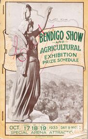 Bendigo Historical Society Inc.
Book - BENDIGO SHOW AND AGRICULTURAL EXHIBITION PRIZE SCHEDULE OCT.17-18-19 1935
... 418. Secretary's Private Residence 176. Showgounds 296.... 418. Secretary's Private Residence 176. Showgounds 296. Book ...Bendigo Show and Agricultural Exhibition Prize Schedule. Oct. Thurs 17,Fri18,Sat 19 1935 Day&Night Special Arena Attraction. County of Bendigo Agricultural, Horticultural and Pastoral society Founded 1859. Rules, Regulations and Conditions of Grand Annual Spring Show. Agricultaral & Industrial Exhibition Thursday, Friday,Saturday october 17th,18th,19th 1935, three days - Three Nights. President: cr M.E. O'Brien. Vice-Presidents: W.H.Wallis, Esq., F. Stanistreet, Esq., and Cr E. Buckland. Hon Treasurer E.J. F. Crawford, Esq. Secretary E.G. Ham Esq. Council: Messrs. A.J.Anderson, M.H.Adams, C.T.H.Bailey, Cr.E.Buckland, M.S.Boyle, Cr.W.M.Bolton, M.J.Brown, Cr. W.J.Clement, Cr. R. Collins, T.E.Carey, J.H.Collins, T.Corrie, J.E.Don, D.Danson, L.L.Dungey, J.H.Daly, F.Goyne, T.Gilmore, Cr. H.C.Harry, A.J.Hamilton, Col.W.E. James, H.M.Leggo, A.Lowndes, J.H.Lienhop, W.J.Lansell, Cr.C.H.Ludeman, C.B. McCallum, B. Mitchell, Cr. J.C.Morrrison, J.Mitchell, E.Nuttall, G.A. Pethard, N. Ramsey, F.Stanistreet, W.J.Stephens, J.C.Symons, R.J. Trahair, E.J.Vanston, A.Whitehead, A.E.Wallis, R.E.Warren and F.A. Young. Patron His Worship the Mayor of Bendigo 9Cr. A. Staples). Life Governors: Hon. H.Keck,M.L.C., W.H.Wallis, Esq., A.Johonson, Esq., W.G.McRobert, Esq. Office: Victoria Chambers, Pall Mall, bendigo. Telephones: Office Bendigo 418. Secretary's Private Residence 176. Showgounds 296.event, agriculture -
 Glen Eira Historical Society
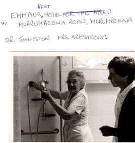
Letter - EMMAUS REST HOME
... . The property turns out to have originally been a private residence.... The property turns out to have originally been a private residence ...This file contains two items pertaining to Emmaus Rest Home: 1/A series of emails exchanged between local resident Mark Upton and John O’Callaghan of the Glen Eira Historical Society, dated 30/01/2008 and 31/01/2008, regarding the history of a derelict property situated at 41 Murrumbeena Road. In the first email, Upton refers to the property of ‘Oakdene’ Aged Care Facility and inquires as to whether the Society possesses any information on it. The next day, O’Callaghan replies that he will investigate. Later that day, Upton recommends O’Callaghan some information on the property he unearthed via Joanne (Jo) Antoni, Executive Assistant at Churches of Christ Community Care. The property turns out to have originally been a private residence owned by the Birtchnell family, sold on 24/01/1945, eventually acquired by the Church and converted into an aged care facility which closed on 16/07/1999 2/Three black-and-white photographs. Two of the photographs portray a resident of the Home, Mrs. Armstrong, and a staff member of the Home, Sr. Johnston, in a bathroom operating a shower. These photographs contain writing on the back identifying the persons. The remaining one portrays Mrs. Armstrong and another, unidentified resident of the Home seated in a bedroom. This one also contains writing on the back, but specifying the name only of the facility. None of the photographs are dated.emmaus, emmaus rest home, emmaus home for the aged, churches of christ community care, antoni joanne (jo), new cumloden grammar school, atkin william t., betheden, waghoo road, ‘oakdene’ aged care facility, carnegie, murrumbeena, upton mark, o’callaghan john, murrumbeena road, neerim road, dandenong road, birtchnell family, birtchnell james, birtchnell elizabeth, birtchnell harold, birtchnell olive, birtchnell kingsley, oakdene crescent, clay will h., johnson sr., armstrong mrs., anglican church, nursing homes, retirement homes, mansions, clocks, fires -
 Melton City Libraries
Newspaper, Melton Fire Station, 1974, 1975
... of the brigade and group base radios were situated in private residences... of the brigade and group base radios were situated in private residences ...In 1975 the Melton Fire Station opened in McKenzie Street. In the 1950s with the introduction two-way HF and later VHF very high frequency radio sets. Melton Rural Fire Brigade was part of the Bacchus Marsh Group. Radio sets where located in the Melton Fire Truck, and in the house of the Barrie family at Ferris Road. This was an ideal location to observe a 360 degree view in all directions when smoke appeared on the horizon. An antenna was erected beside the house. The set OX 7 was located in the kitchen and monitored 24 hours by the family. When an electrical fire occurred at the junction of the electricity to the house there was time to radio the fire station and summons the men working in the paddocks, thus saving the house from possible destruction. With the introduction of UHF – ultra high frequency Vinten Radios the signal was clearer and static and interference lessened and radio traffic became easier to read, and reduced noise levels in the household. In 1974 when the family moved to First Avenue, another antenna and a small building were erected adjacent to the residence and used to house the equipment, maps. Radio traffic consisted of regular schedule times and communication with adjoining groups of brigades such as Bacchus Marsh, Mt Macedon and Little River Groups. Many of the brigade and group base radios were situated in private residences and operated primarily by fire fighters wives who held the position of Communications Officer, either registered as a brigade member or informally.Regional News Gazette article about the construction of a new fire station in Melton and an Express article with brigade members at the opening of the station.emergency services -
 Tarnagulla History Archive
Photograph of Comrie family in Tarnagulla, Comrie family in Tarnagulla, 31st January 1924
... (shown in THA-2019.0031). Behind the residence and outbuildings... (as of 2019), but are no longer used. There are now private residences ...Murray Comrie Collection. The house in this photo was the residence of the town police officer. The town block where the house was located was the base for policing in Tarnagulla from 1878 until the 1990s. At the time of this photo (1924), the father of these children, Angus Comrie Snr was the constable for Tarnagulla. Adjacent to this house was a lockup, office and stable (shown in THA-2019.0031). Behind the residence and outbuildings (in background of this photo) was an adjoining paddock for the police horses. This house was sold for removal in in the 1960s and replaced with a prefabricated residence and small office from Bealiba. These as well as the lockup are still in place (as of 2019), but are no longer used. There are now private residences built on the former police horse paddock. A later image of this house is THA-2019.0032. For almost 100 years the Comrie name has been involved with the Victoria Police. Angus Comrie Snr, joined the force in 1899 and served as constable in Kaniva and Avoca and then in Tarnagulla from late 1909 until 1927. His son Murray Comrie, born in Tarnagulla in 1912 also became a policeman and later a Chief Superintendent, retiring in 1972 and passing away in 1983 after a long illness. Murray Comrie's son Murray Jnr., to avoid confusion became known by his middle name, Neil. Neil Comrie also joined Victoria Police and rose through the ranks to become Chief Commissioner of Victoria Police from 1993 to 2001. The Murray Comrie Collection held by Tarnagulla History Archive was collated in the 1970s by Murray Comrie (1912-1983). Sepia photographic postcard, image depicting members of the Comrie family outside their home in Tarnagulla. According to the note on reverse, the subjects are as follows: On the verandah (left to right) are Murray Comrie, 'Mother' (Mary Ellen Comrie), and Keith Comrie. Angus Comrie Jr. is holding a roped mare. Standing at centre are 'Hilda' and 'Roy' (small child). See second image for handwritten notes on reverse.tarnagulla, police, policing, comrie -
 Tarnagulla History Archive
Photograph of police buildings in Tarnagulla, Police buildings in Tarnagulla, 31st January 1924
... . There are now private residences built on the former police horse.... There are now private residences built on the former police horse ...Murray Comrie Collection. The buildings in this image are (from left to right) the lockup, stable and office of the Tarnagulla Police complex. At far left a small part of the rear of the policeman's residence is visible. This residence is clearly depicted in THA-2019.0030. Behind the residence and outbuildings (in background of this photo) was an adjoining paddock for the police horses. This town block was the base for policing in Tarnagulla from 1878 until the 1990s. At the time of this photo (1924), Angus Comrie Snr was the constable for Tarnagulla, living at the police residence with his family. The residence was sold for removal in in the 1960s and replaced with a prefabricated residence and small office from Bealiba which were used until the 1990s. These as well as the lockup are still in place (as of 2019) on the corner of Victoria and Gladstone Streets. There are now private residences built on the former police horse paddock. For over 100 years the Comrie name has been involved with the Victoria Police. Angus Comrie Snr, joined the force in 1899 and served as constable in Kaniva and Avoca and then in Tarnagulla from late 1909 until 1927. His son Murray Comrie, born in Tarnagulla in 1912 also became a policeman and later a Chief Superintendent, retiring in 1972 and passing away in 1983 after a long illness. Murray Comrie's son Murray Jnr., to avoid confusion became known by his middle name, Neil. Neil Comrie also joined Victoria Police and and rose through the ranks to become Chief Commissioner of Victoria Police from 1993 to 2001. The Murray Comrie Collection held by Tarnagulla History Archive was collated in the 1970s by Murray Comrie (1912-1983).Sepia photographic postcard, image depicting members of the Angus Comrie family standing among police outbuildings in Tarnagulla. Based on the note on reverse of THA-2019.0030, the subjects are probably (left to right): Hilda Comrie (b.1904, married in1907 to Alf Clarke), Roy Comrie (b.1921), Keith Comrie (b.1911, d.1934) and either Angus Comrie Jr. (b.1909) or Murray Comrie (b. circa 1912). See second image for handwritten notes on reverse.tarnagulla, police, policing, comrie -
 Tarnagulla History Archive
Photograph of milk bar and general store, Tarnagulla, Milk bar and general store, Tarnagulla, circa 1960s-70s
... . It is a now private residence. This is a reasonable copy.... It is a now private residence. This is a reasonable copy ...Murray Comrie Collection. This image depicts stores in the main street of Tarnagulla, including the two-storey bank building being used as a licensed general store. The building on the left was also a bank, originally constructed by the Union Bank in 1859, and Is probably the first brick and stone building at Tarnagulla. It was used by the bank until 1888 at which time the Union and Colonial banks amalgamated. After this, the building was used for a variety of purposes. The milk bar section was constructed in the 1920s in an area at the front of what had once been the Bank’s manager’s residence. The Two-story bank building On the right was constructed and used by the Colonial Bank of Australasia (from 1866 to 1888) and, following bank amalgamation, by the Union Bank (from 1888 until closure in 1942). The original site had been occupied by Joseph Foo's store, a large wooden building with attached theatre. While the bank was being built, the Colonial Bank operated from the former Company's Hotel (soon after to become the Borough of Tarnagulla Council Chambers, then the Mechanics’ Institute, and finally, prior to final demolition in 1980, Burstall Hall) The new double-storey building was used by the Colonial Bank from 1866 until 21st February, 1888. The premises were sold to the Union Bank for £2500. The Union Bank moved in and commenced operations on 6th June 1888, continuing until 1942. The building was later used as a general store until the 1990s. It is a now private residence. This is a reasonable copy of an older original. Copy probably made by Murray Comrie in the 1970s. Monochrome photograph depicting a section of Commercial Road, Tarnagulla near the intersection with Poverty Street, including two stores - one a bakery/milk-bar and the other a general store operating in the former Colonial/Union Bank building. Photograph taken from north of milk-bar. Two people walking away from photographer on footpath/curb between the two stores. The building on the left was the Union Bank premises, constructed in 1859 and Tarnagulla's oldest surviving brick building. The Union Bank absorbed the Colonial Bank in 1888, and the Union Bank moved operations next door into the much larger former Colonial Bank premises which had been constructed in 1865/66. After amalgamation, the old Union Bank premises was then used for a variety of purposes from visiting doctor's rooms to cafe, etc. The Union Bank continued to operate at Tarnagulla until closure in 1942, at which time business had fallen away and Tarnagulla Branch had already been downgraded to sub-branch status. tarnagulla, banks, banking, commerce, stores, shopping, shops, food, groceries, buildings, commercial road -
 Kew Historical Society Inc
Plan, Melbourne & Metropolitan Board of Works : Borough of Kew : Detail Plan No.1585, 1904
... a boarding house known as ‘The Towers’. Now a private residence again... known as ‘The Towers’. Now a private residence again, it has ...The Melbourne and Metropolitan Board of Works (MMBW) plans were produced from the 1890s to the 1950s. They were crucial to the design and development of Melbourne's sewerage and drainage system. The plans, at a scale of 40 feet to 1 inch (1:480), provide a detailed historical record of Melbourne streetscapes and environmental features. Each plan covers one or two street blocks (roughly six streets), showing details of buildings, including garden layouts and ownership boundaries, and features such as laneways, drains, bridges, parks, municipal boundaries and other prominent landmarks as they existed at the time each plan was produced. (Source: State Library of Victoria)This plan forms part of a large group of MMBW plans and maps that was donated to the Society by the Mr Poulter, City Engineer of the City of Kew in 1989. Within this collection, thirty-five hand-coloured plans, backed with linen, are of statewide significance as they include annotations that provide details of construction materials used in buildings in the first decade of the 20th century as well as additional information about land ownership and usage. The copies in the Public Record Office Victoria and the State Library of Victoria are monochrome versions which do not denote building materials so that the maps in this collection are invaluable and unique tools for researchers and heritage consultants. A number of the plans are not held in the collection of the State Library of Victoria so they have the additional attribute of rarity.Original survey plan, issued by the MMBW to a contractor with responsibility for constructing sewers in the area identified on the plan within the Borough of Kew. The plan was at some stage hand-coloured, possibly by the contractor, but more likely by officers working in the Engineering Department of the Borough and later Town, then City of Kew. The hand-coloured sections of buildings on the plan were used to denote masonry or brick constructions (pink), weatherboard constructions (yellow), and public buildings (grey). This plan, which covers parts of High Street, Pakington Street and Derby Street is dominated by two historic Kew mansions: ‘Konetta’ and ‘Ramornie’. Ramornie was constructed in 1890 for James Maitland Campbell, three times Mayor of Kew. Sold in 1940, it became a boarding house known as ‘The Towers’. Now a private residence again, it has only one of its three balconies remaining. The location of the missing two balconies can be seen on the plan. In 1903, the grounds of Ramornie included a large tennis court fronting Pakington Street. The rear of the property is shown as extending to Cobden Street. One of Kew’s oldest hotels, the Prospect Hill Hotel on the corner of High and Cobden Street was established in 1858. The outline of the hotel shown on the plan represents the second building on the site. During the 19th century it was often used for electoral meetings. The Prospect Hill Hotel was to be redeveloped again in 1928, by the local architect Robert McIntyre. Since the 1980s, the hotel has been a live music venue, the home of the Melbourne Jazz Club, a restaurant and a liquor outlet.melbourne and metropolitan board of works, detail plans, maps - borough of kew, mmbw 1585, cartography -
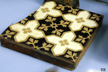 Flagstaff Hill Maritime Museum and Village
Ceramic - Floor Tile, circa 1878
... was increasingly being spent on grandiose private residences and imposing... was increasingly being spent on grandiose private residences and imposing ...This Minton floor tile is from the wreck of the Loch Ard and is currently on display in the Great Circle Gallery at Flagstaff Hill. The iron hulled clipper ship from the Loch Line was heading for Port Phillip from London, when it ran into the cliffs of Mutton Bird Island near Port Campbell. The Loch Ard was laden with a high value cargo including luxury goods intended for display at the Melbourne International Exhibition in 1880. One notable survivor from the ship’s freight manifest was the well packed Minton porcelain peacock, a two meter high ceramic masterpiece of vivid glazed colours. (This is also on display in the Great Circle Gallery). The almost total loss of life and property from the Loch Ard registered as a shocking tragedy for the Colony of Victoria, at a time when social confidence and economic optimism were otherwise high. Wealth generated from Gold and Wool was increasingly being spent on grandiose private residences and imposing public buildings. The demand for quality furnishings and fittings was therefore strong. Among the products consigned to burgeoning colonial markets by the Milton pottery at Stoke upon Trent, were their new range of colourfully patterned but very durable floor tiles ideal for the high-traffic spaces in the large civic buildings then being constructed in Australia and America. These new floor tiles were “encaustic”, meaning that their designs and colours were encased “within” the depth of the tile. Rather than their decorative patterns being glazed onto the surface of the tile, their inlaid designs were created during the manufacturing process, as “coloured slips” (or liquid clay) were poured into a deep pre-molded casting. When fired, the resulting tile was colours-fast and design-fast. The Minton floor tile is significant for its hard-wearing yet attractive design. The shipwreck of the Loch Ard is of significance for Victoria and is registered on the Victorian Heritage Register ( S 417). Flagstaff Hill has a varied collection of artefacts from Loch Ard and its collection is significant for being one of the largest accumulations of artefacts from this notable Victorian shipwreck of which the subject items are a small part. The collections of objects give us a snapshot of how we can interpret the story of this tragic event. The collection is also archaeologically significant as it represents aspects of Victoria's shipping history that allows us to interpret Victoria's social and historical themes of the time. Through is associated with the worst and best-known shipwreck in Victoria's history. A square Minton floor tile with a dark brown, beige and white pattern. The tile has a piece broken off along one side and some chipping along the edges. This ‘encaustic’ floor tile was recovered from the shipwreck of the LOCH ARD. Branded "... MINTON&CO Patent ..."flagstaff hill, warrnambool, flagstaff hill maritime museum, shipwreck coast, flagstaff hill maritime village, great ocean road, loch line, loch ard, captain gibbs, eva carmichael, tom pearce, glenample station, mutton bird island, minton floor tile, encaustic tile, melbourne international exhibition, floor tile -
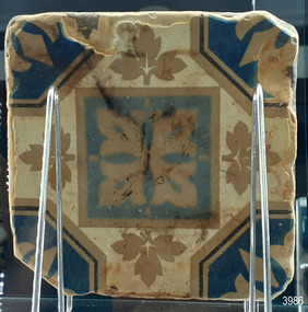 Flagstaff Hill Maritime Museum and Village
Ceramic - Floor Tile, circa 1878
... was increasingly being spent on grandiose private residences and imposing... was increasingly being spent on grandiose private residences and imposing ...This Minton floor tile is from the wreck of the Loch Ard. The iron-hulled clipper ship from the Loch Line was heading for Port Phillip from London, when it ran into the cliffs of Mutton Bird Island near Port Campbell. The Loch Ard was laden with high-value cargo including luxury goods intended for display at the Melbourne International Exhibition in 1880. One notable survivor from the ship’s freight manifest was the well-packed Minton porcelain peacock, a two-meter high ceramic masterpiece of vivid glazed colours. (This is also on display in the Great Circle Gallery). The almost total loss of life and property from the Loch Ard registered as a shocking tragedy for the Colony of Victoria, at a time when social confidence and economic optimism were otherwise high. The wealth generated from Gold and Wool was increasingly being spent on grandiose private residences and imposing public buildings. The demand for quality furnishings and fittings was therefore strong. Among the products consigned to burgeoning colonial markets by the Milton Pottery at Stoke upon Trent, were their new range of colourfully patterned but very durable floor tiles ideal for the high-traffic spaces in the large civic buildings then being constructed in Australia and America. These floor tiles were “encaustic”, meaning that their designs and colours were encased “within” the depth of the tile. Rather than their decorative patterns being glazed onto the surface of the tile, their inlaid designs were created during the manufacturing process, as “coloured slips” (or liquid clay) were poured into a deep pre-moulded casting. When fired, the resulting tile was colour-fast and design-fast. The Minton floor tile is significant for its hard-wearing yet attractive design. The shipwreck of the Loch Ard is of significance for Victoria and is registered on the Victorian Heritage Register ( S 417). Flagstaff Hill has a varied collection of artefacts from Loch Ard and its collection is significant for being one of the largest accumulations of artefacts from this notable Victorian shipwreck of which the subject items are a small part. The collections of objects give us a snapshot of how we can interpret the story of this tragic event. The collection is also archaeologically significant as it represents aspects of Victoria's shipping history that allows us to interpret Victoria's social and historical themes of the time. Through is associated with the worst and best-known shipwreck in Victoria's history. A square Minton floor tile with a white background, and beige, dark blue, light blue and black geometric pattern as well as leaves in the design. The tile has corner broken off and some chipping along the edges. The reverse has five rows of five evenly spaced holes. The back of the tile has inscriptions. Made by Minton & Co. at Stoke upon Trent. This encaustic floor tile was recovered from the shipwreck of the LOCH ARD. Branded "... MINTON&CO / PATENT / STOKE UPON TRENT"flagstaff hill, warrnambool, flagstaff hill maritime museum, shipwreck coast, flagstaff hill maritime village, great ocean road, loch line, loch ard, captain gibbs, eva carmichael, tom pearce, glenample station, mutton bird island, minton floor tile, encaustic tile, melbourne international exhibition, floor tile, minton tile, minton & co., stoke upon trent -
 Glen Eira Historical Society
Album - Album page, Glenferrie Street, 4, Circa 1972
... , designed and built for his private residence, a brick house..., designed and built for his private residence, a brick house ...This photograph is part of the Caulfield Historical Album 1972. This album was created in approximately 1972 as part of a project by the Caulfield Historical Society to assist in identifying buildings worthy of preservation. The album is related to a Survey the Caulfield Historical Society developed in collaboration with the National Trust of Australia (Victoria) and Caulfield City Council to identify historic buildings within the City of Caulfield that warranted the protection of a National Trust Classification. Principal photographer thought to be Trevor Hart, member of Caulfield Historical Society. Most photographs were taken between 1966-1972 with a small number of photographs being older and from unknown sources. All photographs are black and white except where stated, with 386 photographs over 198 pages. From Glen Eira Heritage Management Plan 1996 by Andrew Ward: In 1905, most of portion 27 was vacant land, however Glenferrie Street had been formed and the land subsequently subdivided. In 1906, Robert Joseph Haddon, architect and painter, designed and built for his private residence, a brick house on the west side. Haddon named the house "Anselm". Also built on the property were a garage and fibro cement studio. "Anselm" is architecturally important at the State level as a substantially intact, highly personalised and boldly expressed house expressive the Arts and Crafts movement and incorporating Art Nouveaux enrichment in a variety of forms, the use of ornamental terra cotta tiles to the comer tower being of special note. Its importance at the State level is strengthened by its place as the home of the noted architect and Melbourne's most influential exponent (Freeland, J.M., Architecture in Australia, p. 213) of the Art Nouveaux movement.https://vhd.heritagecouncil.vic.gov.au/places/4442 Victorian Heritage Register: What is significant? Anselm was designed by noted English born architect Robert Joseph Haddon(1866-1929) as his own house and constructed in 1906. A single storey Arts and Crafts influenced red brick house with attic, Anselm has a pyramidal slate roof with prominent chimney stacks. There is a octagonal corner tower with saucer shaped domed roof surmounted by a weather vane, and the tower has decorative terracotta panels immediately below the eaves line. The front door opens immediately into a large living or common room, screened from view by a timber and bottle glass screen. The large room was designed to function as a drawing and dining room. The house is rich with hand crafted details including door and window furniture, wrought iron gutter brackets, fireplaces (one with built in wood box), and fire tools. The interior decoration includes hand painted frieze of Port Phillip in the study, and a hand painted frieze of turbulent sea with sailing boats in the tiled bathroom. There is a small hand painted tile at the base of the tower which states ?This building was erected AD1906 from designs by Robt J Haddon FRIBA,Lond FRIVA Melb Architect?. He also designed an attic addition which was constructed in 1927. Anselm is substantially intact although the double casement window immediately to the south of the front door was originally circular....Page 60 of Photograph Album with three exterior photographs (one portrait and two landscape) of Anselm.Hand written: 4 Glenferrie Street [top right] / ANSELM 4 Glenferrie St [under top photo] / 60 [bottom right] trevor hart, anselm, art nouveaux, arts and crafts, tower, bay window, glenferrie street, robert joseph haddon, 1900's, terra cotta tiles, double storey, caulfield north, corner tower, gates, cast iron work -
 Glen Eira Historical Society
Album - Album page, Glenferrie Street, 4, Circa 1972
... , designed and built for his private residence, a brick house..., designed and built for his private residence, a brick house ...This photograph is part of the Caulfield Historical Album 1972. This album was created in approximately 1972 as part of a project by the Caulfield Historical Society to assist in identifying buildings worthy of preservation. The album is related to a Survey the Caulfield Historical Society developed in collaboration with the National Trust of Australia (Victoria) and Caulfield City Council to identify historic buildings within the City of Caulfield that warranted the protection of a National Trust Classification. Principal photographer thought to be Trevor Hart, member of Caulfield Historical Society. Most photographs were taken between 1966-1972 with a small number of photographs being older and from unknown sources. All photographs are black and white except where stated, with 386 photographs over 198 pages. From Glen Eira Heritage Management Plan 1996 by Andrew Ward: In 1905, most of portion 27 was vacant land, however Glenferrie Street had been formed and the land subsequently subdivided. In 1906, Robert Joseph Haddon, architect and painter, designed and built for his private residence, a brick house on the west side. Haddon named the house "Anselm". Also built on the property were a garage and fibro cement studio. "Anselm" is architecturally important at the State level as a substantially intact, highly personalised and boldly expressed house expressive the Arts and Crafts movement and incorporating Art Nouveaux enrichment in a variety of forms, the use of ornamental terra cotta tiles to the comer tower being of special note. Its importance at the State level is strengthened by its place as the home of the noted architect and Melboume's most influential exponent (Freeland, J.M., Architecture in Australia, p. 213) of the Art Nouveaux movement. Victorian Heritage Register https://vhd.heritagecouncil.vic.gov.au/places/4442 What is significant? Anselm was designed by noted English born architect Robert Joseph Haddon(1866-1929) as his own house and constructed in 1906. A single storey Arts and Crafts influenced red brick house with attic, Anselm has a pyramidal slate roof with prominent chimney stacks. There is a octagonal corner tower with saucer shaped domed roof surmounted by a weather vane, and the tower has decorative terracotta panels immediately below the eaves line. The front door opens immediately into a large living or common room, screened from view by a timber and bottle glass screen. The large room was designed to function as a drawing and dining room. The house is rich with hand crafted details including door and window furniture, wrought iron gutter brackets, fireplaces (one with built in wood box), and fire tools. The interior decoration includes hand painted frieze of Port Phillip in the study, and a hand painted frieze of turbulent sea with sailing boats in the tiled bathroom. There is a small hand painted tile at the base of the tower which states ?This building was erected AD1906 from designs by Robt J Haddon FRIBA,Lond FRIVA Melb Architect?. He also designed an attic addition which was constructed in 1927. Anselm is substantially intact although the double casement window immediately to the south of the front door was originally circular....Page 61 of Photograph Album with one exterior photograph (portrait) of Anselm.Hand written: 61 [bottom left] trevor hart, anselm, art nouveaux, arts and crafts, tower, bay window, glenferrie street, robert joseph haddon, 1900's, terra cotta tiles, double storey, caulfield north, corner tower, brick house, attics