Showing 1469 items matching "site no 2"
-
 Warrnambool and District Historical Society Inc.
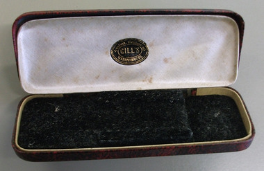
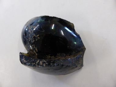
Domestic object - Case, spectacles, spectacles Case, 1900-1960
Frederick James Gill operated from the early part of the 20th century, through until around the 1960’s. He died in Warrnambool in 1961. There is still a jeweller operating from the same site today.A common item with a link to a Warrnambool businessDark red and black patterned hard case with rounded corners. Lined with cream satin with black felt insert. Metal hinges.Oval sticker: Gill’s jewellers, watchmakers Warrnambool.warrnambool, f.j. gill, jeweller, frederick james gill -
 Warrnambool and District Historical Society Inc.
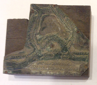
Functional object - Printing block: Warrnambool Historical Society logo, 1980s
This printers block was made for the Warrnambool and District Historical Society and used to print letterheads, envelopes and cards. The impression on the block is of the sketch map drawn by Thomas Price of Port Fairy of the Warrnambool Harbour site when he wrote to Superintendent Charles LaTrobe in 1844 regarding the suitability of the site for a new town. The letter is regarded as an important impetus for La Trobe to consider establishing the town of Warrnambool and so the sketch was used by the Historical Society as its logo on letterheads etc for many years. It was also used as the heading for the Society newsletters from the late 1980s to late 2007.This block of the Thomas Price sketch was used by the Historical Society for many years for its printed material and the sketch was used as its logo for about 20 years so it is an important part of the Society’s history and the block is kept as a reminder of this.This is a printing block with an impression made of metal and attached to a wooden block. The wood is in layers of dark and light coloured wood and has a piece cut out at the top left hand corner. The impression is a representation of the sketch map of Warrnambool Harbour made by Thomas Price in 1844.Sketch map of Warrnambool Harbour 1844warrnambool & district historical society, thomas price sketch -
 Warrnambool and District Historical Society Inc.
Souvenir - Personal item: Rouge holder
This is a souvenir of the British Empire Exhibition of 1925. This exhibition, designed to showcase the industrial and natural resources of the countries in the British Empire was on a 216 acre site at Wembley, England. In 1923 the Wembley Stadium was completed and the F.A. Cup Final was held there. In 1924 the Exhibition was opened by King George V in a first ever radio broadcast by a British monarch. There were Palaces of Industry, Engineering, Horticulture and Art and Pavilions housing exhibits from most countries in the British Empire. 17 million people visited in 1923 and there were 11 million visitors in 1925 when the exhibiton was re-developed. Wembley Stadium was reconstructed in 2002. This item has no local provenance but is of some interest because of its connection to the British Empire Exhibition of 1925. It is a good example of the type of souvenir that was bought by visitors to the Exhibition. This is an enamelled metal container, circular (octagonal on the outside edges) in shape with a short handle. The central area is slightly recessed to take a small amount of rouge (a red powder compound for the face, usually the cheeks). A pad to apply the rouge to the face is missing. There is a metal hinged lid with a clip and a small ring at the end of the handle, possibly to contain a chain for it to hang around the neck. The wording on the front is black on a blue and green enamelled backgroundRaised image of a lion with the words underneath ‘British Empire Exhibition, 1925’rouge holder, british empire exhibition 1925 -
 Warrnambool and District Historical Society Inc.
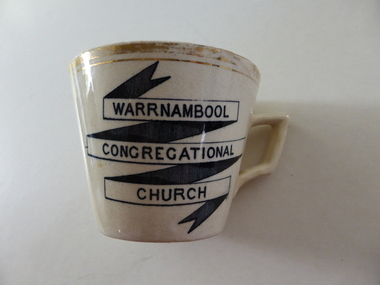
souvenir cup, Warrnambool Congregational Church
The Warrnambool Congregational Church was established with a meeting called in April 1862 and over the ensuing months a congregation with first pastor Rev W Pentland was established. After initially meeting at the small Temperence Hall in Liebig St, land was purchased at the corner of Liebig and lava St and the first church opened in March 1864. It remained on this site until the site was sold to the T & G Assurance in 1939 and land known as Kianga Estate was purchased on the corner of Lava and Henna Streets.It became part of the amalgamation with other churches to form the Uniting Church in 1977.This cup is possibly a souvenir from the 50th anniversary celebrations held in 1912. A common object which is linked to one of warrnambool's longest running churches.Cream china cup with thick gold rim and black test in banner style on one side of the cup. Warrnambool Congregational Church on front of cup . 338 written on bottom and 4 on paper labelwarrnambool, warrnambool congregational church -
 Warrnambool and District Historical Society Inc.
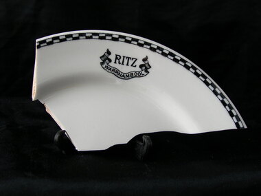
Plate, Ritz Warrnambool - fragment, Early 20th century
The Ritz was situated near the corner of Lava and Liebig St. The site was originally a hotel which traded under various names, including The Prince of Wales Dining Room, The Stork The Red Lion and later the Princess Royal after a fire in 1880 and it was delicensed in 1900. it later became the Mia mia cafe before a change to the Ritz. A fragment from Warrnambool's past.Fragment of white plate with black and white check edge and logo of Ritz with Warrnambool in banner below it.Ritz Warrnambool.warrnambool, ritz cafe warrnambool -
 Warrnambool and District Historical Society Inc.
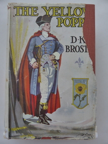
Book, The Yellow Poppy by D K Broster, 1937
This book comes from the property of Lyndoch near the mouth of the Hopkins River. George Rolfe, a tea merchant from Melbourne, established Lyndoch in 1875 and Miss Florence Lake, daughter of Miss Annie Lake, later Mrs George Rolfe, inherited the property with her sister Annie. In 1920 Florence Lake built a large house called Lyndoch. She had a Rolls Royce car and a chauffeur and was a tireless worker for local charities. Florence Lake died in 1946 and the property became the site of an Aged Care Facility in Warrnambool. Florence Lake’s house now forms part of the hostel section of this facility. This book would have been in the Lyndoch library during Florence Lake’s time there. D K Broster ( Dorothy Kathleen) was a popular writer of historical novels in the early part of the 20th century. The Flight of the heron being her most acclaimed This book is of interest as it came from the historically-important property and house known as Lyndoch and so it is connected to Miss Florence Lake, a prominent person in Warrnambool in the first half of the 20th century. This is a hard cover book of 439 pages. It has a red cover with black lettering on the front and spine. It also has a dust cover which has a colour image of a man in late 18th century attire and a shield containing a yellow poppy. The dust cover is partly torn away. The book has 46 chapters. The inscription is handwritten in black ink. ‘Lyndoch Xmas 1937’lyndoch, florence lake, history of warrnambool -
 Warrnambool and District Historical Society Inc.
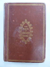
Book, The book of sacred song, 1864
This book has been given to John Ardlie by Lewis Gilles in 1866. John Martin Ardlie came to Warrnambool in 1852 as the Clerk of Courts and remained in this position until 1868. He died in 1872. He was a leading figure in community affairs for twenty years and Ardlie Street in Warrnambool is named after him. His family home was Wyton, site of the old convent at Emmanuel College today. Lewis Gilles, important in the early history of Tasmania as a bank owner and breeder of cattle, came to Warrnambool in 1854 as the first resident Police Magistrate. He remained until 1866 when he went to England (the occasion of his presentation of this book to John Ardlie). He died in 1884 in South Australia. Gilles Street in Warrnambool is named after him.This book is of high significance because of its connection to two very important early residents of Warrnambool – John Ardlie and Lewis Gilles. This is a hard cover book of 336 pages. The cover is brown with gold ornamentation and lettering on the front cover and spine. The pages are gilt-edged. The first letter of each hymn is ornamented and there is an illustration covered with tissue paper on the first page. One page shows silverfish damage and the cover is partly detached from the binding. The cover is frayed in places and a little stained. The inscription is handwritten in black ink. ‘Presented to J. M. Ardlie by his friend and comrade L.W. Gilles 1864 Worthing Sussex on departing from Warrnambool 4 May 1866’. john ardlie, lewis gilles, history of warrambool -
 Warrnambool and District Historical Society Inc.
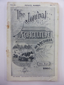
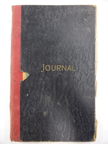
Booklet, The Journal of the Department of Agriculture of Victoria 1905, 1905
This journal has been produced in 1905 for the Government of Victoria under the direction of the Minister for Agriculture, the Hon. George Swinburne, M.L.A. It has articles on agriculture in Victoria, including an article on how to increase and improve our dairy products and an article on the Grasmere Butter Factory. This journal produced in 1905 is of considerable interest because it has an article on the inspection of the Grasmere Butter Factory and the resultant erection of a new building on the site. Dairying is a major industry in the Warrnambool area and this journal contains important historical information and photographs.This is a soft cover journal of 68 pages (pages 482 to 550 in Part 7 of a journal). The front cover has a black and white photograph of a wheat harvesting scene. The back cover is missing. The first two pages have advertisements for insurance and banking firms. The journal contains black and white photographs and statistics tables. The pages show considerable silverfish damage. The journal is bound with cotton thread and rust marks show where metal staples may have been removed. grasmere butter factory, dairying in the western district, warrnambool history -
 Warrnambool and District Historical Society Inc.
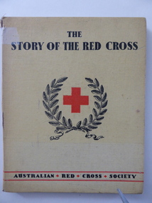
Booklet, The story of the red cross, 1940s
This book published by the Australian Red Cross Society has been written by Joan and Daryl Lindsay. The book features the work of many Australian artists in the 1940s. The inscription shows that the book was a prize awarded to Joyce Goodall, a pupil at Warrnambool Technical School. This school commenced in 1913 in Timor Street, Warrnambool, a site now occupied by T.A.F.E. Warrnambool Technical School moved to a Caramut Road site and is now called Brauer College. The book was the James Swan Memorial Prize. Swan had a furniture business in Warrnambool. He was a City Councillor (1922-1936) and Mayor (1926-1928) and Swan Reserve in Raglan Parade is named after him. The donor of the prize, Mrs R. Pattison, was the daughter of James Swan and the wife of Ralph Pattison, Warrnambool Librarian. The winner of the prize, Joyce Goodall (Mrs Joyce Milne) was a member of the Goodall families which have been in the Warrnambool and Mortlake areas since the 1860s. John King was the first Head Teacher of Warrnambool Technical School and remained in that position for 29 years. This book is of interest as all of the names mentioned in the inscription plate in this book have a place in Warrnambool’s history. This is a hard cover book with the pages unnumbered. The cover is yellow with black lettering and the front cover has an emblem of the Red Cross and a laurel wreath in red and black. The cover is partly torn and has been mended with adhesive tape. The contents of the book are largely pictorial and illustrative with some text. The inscription is typed. ‘Warrnambool Technical School, Labor to Efficiency, 9th Dec. 1942, for Proficiency in English, James Swan Memorial Prize, donated by Mrs R. Pattison, Awarded to Joyce Goodall, John King, Principal.’ warrnambool technical school, history of warrnambool, john king, james swan, joyce goodall -
 Warrnambool and District Historical Society Inc.
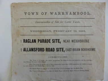
Document, Voting paper Cattle Yards 1883, 1883
This voting card was to determine the site of the new cattle yards in Warrnambool. The choice was between a Raglan Parade site (the present Swan Reserve Children’s Services centre and an Allansford Road site east of the Old Bryen Boiroimhe Hotel (Corner of japan Street and Raglan Parade. The Raglan Parade site at the corner of Kepler Street was the preferred site polling 373 to 222. These saleyards were moved to the present site in Caramut Road in 1970. Portions of the old stone walls around the Raglan Parade / Kepler Street site can still be seen.This document has local interest particularly as the site of the Warrnambool saleyards is still a matter of some discussion.White paper with black text Town of Warrnambool in Capital letters at top of document. The document reads Determination of site for cattle yards. Wednesday February 7th 1883. The back has small sticker W22cattle yards warrnambool, warrnambool, warrnambool saleyards -
 Warrnambool and District Historical Society Inc.
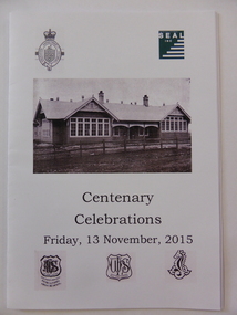
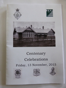
Publication, Centenary Celebrations 1915-2015, 2015
The booklet gives an overview of the history of the schools which occupied the site as well as information from newspapers and lists of staff at various times over the years.A large number of Warrnambool students would have passed through this school and hence this program would have social and historical significance to them. 16 page booklet with white cover. Front cover has black and white photo of the school with the five logos/ badges relating to each of five schools which have occupied it over the 100 years. The back cover has the words to the Warrnambool High School song written in 1937.The centre pages have photographs of various student groups.Appreciations for SEAL Work for the Dole program, Glen Morgan, Russ Goodear, Angeleen & Marlene Fogarty, Ray Welsford, Pat Varley, Jim & Ros Thomson, Committee of Management and staff of SEAL.warrnambool agricultural high school, warrnambool high school, warrnambool technical school, warrnambool special school -
 Warrnambool and District Historical Society Inc.
Invitation, Centenary of the School on the Hill, 2015
An Invitation to the Centenary of the School on the Hill which housed at various times, the Warrnambool Agricultural High School, Warrnambool High School, Warrnambool Technical School SEAL Inc and with the Warrnambool Special School on the same site.Many students from Warrnambool and the surrounding district would have been students at one of the various schools which have occupied this site from time to time from the earliest in 1915 to the present time and as such has historic and social significance to the town.White paper with black print A4sizewarrnambool agricultural high school, warrnambool high school, warrnambool technical school, schools of warrnambool, warrnambool special school -
 Warrnambool and District Historical Society Inc.
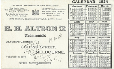
Document, Blotter Calendar 1924, 1924
As this blotter came with a collection of dockets etc from the Warrnambool Club it is assumed that it was a blotter used at the Club. It comes from the firm of B.H.Altson, a tobacconist, probably a supplier of goods to the Warrnambool Club. Henry Altson, a tobacconist, built an eight-storeyed building in 1903 at the corner of Elizabeth and Collins Streets in Melbourne (on the site of the first brick building in Melbourne). Altson’s tobacconist shop occupied the prime corner position for many years. The Warrnambool Club was a gentlemen’s club established in Warrnambool in 1873 and the Warrnambool Club building in Kepler Street erected in 1877 and the Club still exist. This blotter is of some interest as an example of the Melbourne firms patronized by the Warrnambool Club in 1924This is a piece of blotting paper advertising on one side the firm of B.H. Altson, Tobacconists, in Melbourne. It has a calendar for 1924. The printed material is black on a creamy-coloured surface. The blotting paper on the other side has been slightly used (blotted handwriting) There are also some handwritten figures scrawled across the advertisement, the meaning of which is not known.‘B.H. Altson Pty Ltd, Tobacconists, Altson’s Corner, Collins Street, Melbourne, Telephone 2076, With Compliments’.warrnambool club, b.h.altson,, tobacconist -
 Warrnambool and District Historical Society Inc.
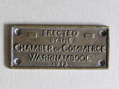
Brass Plate, Chamber of Commerce 1933, 1933
This plaque has been attached to a Warrnambool installation in 1933. It is not known to which site this refers but it may have been the Warrnambool Information Pavilion which was erected outside the old Warrnambool City Council Chambers. There have been many Warrnambool Chambers of Commerce over the years. These were established by Warrnambool businessmen and women to promote the interests of the town/city and to encourage the development of local industry and the tourism trade. This plaque is of great local interest but unfortunately does not have a clear provenance.This is a small brass plaque. The plaque has four holes at each corner for attachment to a building or other object. ‘Erected by the Chamber of Commerce, Warrnambool, 1933’warrnambool chamber of commerce, warrnambool city council chambers, plaque -
 Warrnambool and District Historical Society Inc.
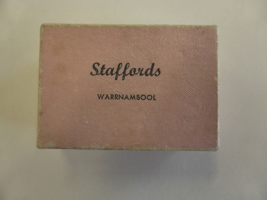
Box, Jewellery Box, Mid 20th century
This is a jewellery box from the Warrnambool business of Stafford, the jeweller. The Staffords shop was at 120 Liebig Street and operated in the 1960s, 70s, 80s, 90s and early 2000s. The site is still a jewellery shop. This box is of minor interest as an example of a small jewellery box from the mid 20th century.This is a small cardboard box covered with salmon-pink paper on the outside. It is empty but once contained an item of jewellery. The pink paper is slightly buffed. ‘Staffords Warrnambool’staffords, jewellers, warrnambool, jeweller box -
 Warrnambool and District Historical Society Inc.
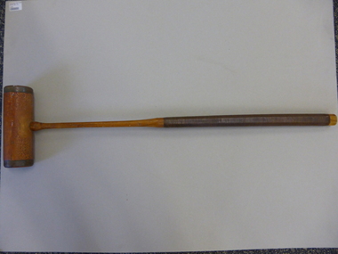
Mallet, Croquet Mallet, Late 19th century/early 20th century
This croquet mallet belonged to Martha Beatrice McCullough (nee Barker), wife of George McCullough, who died in November 1931 at the age of 50. She lived at the house at 113 Koroit Street named ‘Heatherlie’ (the site of the current retirement residential units) and owned and managed the Silver Stream Café in Liebig Street. The mallet was used by her and may have been used by her mother before her. Croquet was a popular sport, especially for women after the 1880s. This is a significant item as it is an artefact associated with women’s sport in the late 19th century and early 20th century. It is also important as it belonged to a local Warrnambool resident and businesswoman whose granddaughter resides in Warrnambool today.This is a brown-coloured wooden croquet mallet. The handle has ribbed leather binding and the mallet has brass edging and brass on the under section attached with twelve brass screws. The handle is octagonal shaped. The lower section of the handle and the mallet have been varnished. On the mallet: ‘The Reel’croquet, warrnambool -
 Warrnambool and District Historical Society Inc.
Bottle, Bottle fragment Woodford hotel est 1845, 19th century
This fragment was found in Bridge Road, Woodford on the site of the Travellers’ Rest Hotel, Woodford and it is believed that it may date from the time when the hotel was operating. The Travellers’ Rest Hotel in Woodford was established some time in the 1840s with the first known date, 1847. It pre-dates the settlement of Warrnambool founded in late 1847. The Travellers’ Rest Hotel was established by William Kirby and his wife Mary took over the hotel management when her husband was drowned in August 1847. The hotel had seven other licensees and closed in 1875. If this item comes from the time of the Travellers’ Rest Hotel in Woodford then it is of considerable interest as an early memento of that hotel and the early days of Woodford. This is a fragment of a black bottle or other domestic item. It is made of heavy glass and is curved and could be part of the base of the object. history of woodford, travellers’ rest hotel, woodford, warrnambool history -
 Warrnambool and District Historical Society Inc.
Book, Nurse Thompson's private hospital Journal, Early 20th century
This journal contains the original records of Nurse Thomson’s Private Hospital in Warrnambool. It contains the records of the births at the hospital from 1907 to 1924. The early records give the name of the mother and later ones give the name of the attending doctor. Ellen Thomson (1872-1940), the daughter of Eliza and Charles Trew, conducted a private hospital in Raglan Parade, Warrnambool (the site of the old Tatts Hotel Bottle Shop, next to where McDonalds Food Store is today). This journal is of considerable significance as it is an original one, listing births at a private hospital in Warrnambool from 1907 to 1924. It is the only local original private hospital journal in the collection of Warrnambool and District Historical Society and pre-dates the establishment of a maternity wing at the Warrnambool Hospital.This is a foolscap-size book with a black hard cover and gold printing on the front. It has red binding which is in a somewhat tattered state. The cover is coming away from the binding and some pages are loose. The book has printed red and blue lines and the entries on these pages are handwritten in black ink and pencil. There is a loose sheet of paper giving information on the journal and the donor. nurse thomson, private hospitals in warrnambool, history of warrnambool -
 Warrnambool and District Historical Society Inc.
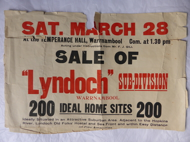
Poster, Lyndoch Sub-Division
This is a poster advertising the sale of the Lyndoch sub-division in Warrnambool with the sale of 200 housing sites. The sale took place about 1958 with the land sold by Frederick Gill, a Warrnambool jeweller. The land was previously owned by George Rolfe who had acquired the land near the mouth of the Hopkins River in the 1880s and named the property ‘Lyndoch’. He bought the surrounding land at a later time. This sub-division came to be known as the Gill Estate. It was a valuable site as many of the allotments fronted the sea and others were adjacent to the Hopkins River. This poster, although tattered, is of interest as it has many details of the Gill Estate sub-division and will be useful to researchers. This is a cream-coloured paper poster with black and red printing. The poster has a small map in a circle shape showing the location of the streets and a larger map section showing the streets and the allotments to be sold. The poster is in two pieces and the edges are torn and, in some sections, missing. The streets map has some pencil annotations. history of warrnambool, lyndoch, warrnambool, george rolfe, frederick gill -
 Warrnambool and District Historical Society Inc.
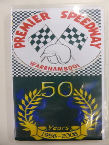
DVD, Premier Speedway
The Warrnambool Hot Rod Club was formed in 1958 at the Warrnambool racecourse. In 1969 the Club transferred to a site on the Princes Highway. Today the Club is the Premier Speedway Club and the major annual event is the Grand Annual Sprintcar Classic. This DVD was produced to celebrate the 50th Anniversary of the Warrnambool Premier Speedway Club. It is retained as a souvenir of that anniversaryThis is a DVD with two discs contained in a plastic folder. The cover of the folder is multi coloured and contains photographs of speedway vehicles, an image of two chequered flags, a helmet and a laurel wreath.PREMIER SPEEDWAY WARRNAMBOOL 50 Years 1958-2008premier speedway warrnambool, car racing warrnambool, history of warrnambool -
 Warrnambool and District Historical Society Inc.
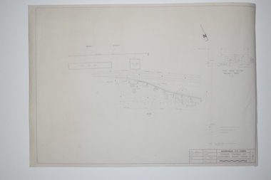
Documents, WCC Proposed turntable site railway station, 1968; 1989
... (sic) St.’ .2 ‘Proposed Turntable Site Warrnambool Railway... ‘Locality Plan of Rail Crossings Liebig St. & Gillies (sic) St.’ .2 ...These two plans are copies and show drawings for a proposed turntable at the Warrnambool Railway Station and railway crossings at Gilles Street in the Liebig Street precinct. The Warrnambool Railway was opened in 1890 and the Warrnambool Railway Station building was erected a few years later. These plans, being copies, are of minor interest as they show plans of some projects in the Warrnambool Railway Station precinct in the latter half of the 20th century.These are two sheets of cream-coloured paper with plans (copies of original) drawn up in black ink. The drawings are fading somewhat and are faint in places. One sheet (.2) has a piece missing from the top left hand corner. .1 ‘Locality Plan of Rail Crossings Liebig St. & Gillies (sic) St.’ .2 ‘Proposed Turntable Site Warrnambool Railway Station’ plans, warrnambool railway, warrnambool rail turntable -
 Kiewa Valley Historical Society
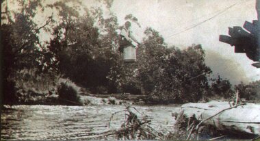
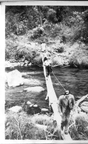
Photo - Tawonga Bridge.( Set of 2 photos)
Photo 1 - Rene Roper (Postmistress) crossing swollen Kiewa River on a milk can flying fox at Tawonga, during high winter waters Photo 2 - First Tawonga bridge was built in 1884- destroyed by floods in 1916. New bridge constructed 1923 and destroyed in 1953. Present concrete bridge constructed in 1986 and named Ryders BridgeBridge construction over Kiewa River at TawongaCopies of two original black and white photos. Photo 1 - Flying fox at site of Tawonga Bridge over the Kiewa River Photo 2 - Timber pile bridge over the Kiewa River at Tawongatawonga bridge, kiewa valley -
 Kiewa Valley Historical Society
Photographs x 2 - Clover Dam, Circa 1940's
As part of the push to cut electricity costs and diversify supply, the Victorian Government (circa 1930) implemented the conversion strategy from mainly brown coal supply to hydro - electricity. The Kiewa Hydroelectric Scheme became the largest scheme of its kind in the State Of Victoria and the second largest scheme in Australia. Clover Dam and Power Station were built by the State Electricity Commission of Victoria as part of the Kiewa Hydro Electric Scheme from the late 1930's to the early 1940's. This dam was constructed to supply water to feed four turbines (62 mega watts) at the West Kiewa Power Station. This was at the forefront of sustainable "Green" energy. Costs associated with power supplies is still a major incentive of governments, however environmentally friendly alternatives such as wind and nuclear have also made inroads. The Kiewa valley and its surrounding alpine catchment were looked at(Victorian State Government), from the beginning of the twentieth century as a source of alternate power for an ever-increasing demand for electricity by growing population and heavy industrial areas within Melbourne City and State regions. Construction of dams, such as Clover Dam provided the large quantity holding areas of water required to turn the turbines at the various power stations to provide the electricity needed. The impact of these controls by moderating water run-off from the alpine regions is beneficial in reducing flooding from thawing of snow on the alps. This by-product allows agriculture and grazing to be less vulnerable to seasonal flooding thereby resulting in a more stable annual production level. Photographs also document early engineering and building techniques used in the construction of dams and power stations during the 1940’s and 1950’s. Note the lack of safety equipment and suitable work attire worn by construction workers on the sites 1. Black and white photograph of Clover Dam under construction. Has a .5cm white border around photo 2. Black and white photograph of Clover Dam under construction showing workmen at work. Has a .5cm white border around photo Written in pencil on back of both photographs - Clover Damclover dam, secv -
 Kiewa Valley Historical Society
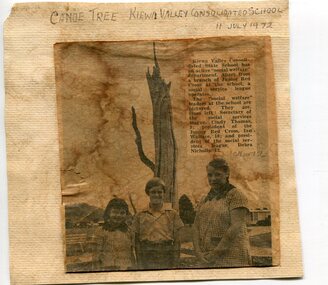
Newspaper clipping 11/7/72 Canoe tree in Kiewa & Photo-Tawonga Homestead
1. Kiewa Valley Consolidated School was established in 1953 combining Dederang North, Kergunyah, Gundowring, Kiewa, Gundowring Upper, Red Bluff, Charleroi and Gundowing North schools on a 10 acre site with 11 rooms at Kiewa. The bark was cut from the canoe tree, by aboriginal craftsmen, to produce a canoe for fishing in the rivers running through the Kiewa Valley either before or just after the 1800's. The tree trunk, located at Kiewa, would have been used at the beginning of European settlement in the Kiewa Valley or just before contact was made. 2. Pictorial record of the graves of early pioneers C Ibbotson, Mrs Elizabeth Eyre and John Eyre who died between 1858 – 1904, all located at Tawonga Homestead 1. The above schools are in the Kiewa Valley. The date and number of combined schools give insight into the change in population and families in the Kiewa Valley before and after 1953. The tree was found along the Kiewa River and indicates that Aborigines lived by the river and used tree bark to craft canoes to cross rivers and to fish in the deeper sections of the river. 2. Pictorial record of the early history of Kiewa Valley pioneers whose descendants have lived and worked in the Kiewa Valley for many years 1. Newspaper article of local school children visiting a canoe tree in Kiewa July 11, 1972. mounted on buff card 2. Black and white photo of pioneer graves at old Tawonga Homestead. Mounted on buff card 1. Handwritten in black ink above newspaper clipping ‘Canoe Tree Kiewa Valley Consolidated School. 11 July, 1972’ Handwritten in pencil at bottom of article ’10 Nov. ‘72’ 2. Handwritten in black ink above photo ‘Tawonga Homestead graves’ Handwritten below photo ‘T Ibbotson D. 1858, Elizabeth Eyre D. 1879, John Eyre D 1879, John Eyre D. 1904 tawonga homestead, canoe tree at kiewa, tawonga graves -
 Kiewa Valley Historical Society
Photographs x 2 1. Lake Guy & Bogong Village 2. Bulldozer moving rocks
1. In 1940 Field Headquarters for the Kiewa Scheme were established at Bogong with office, workshop facilities and accommodation for workmen, staff and some families constructed. (There had been a 'tent camp' on this site in 1939 but was destroyed by bushfires) Construction of accommodation continued until 1947. A total of 40 houses plus a hostel for single staff, post office, police station, medical centre and primary school all with water and sewerage and electricity supply. The staff hostel was known as Kiewa House and is now occupied by the Education Department. Lake Guy was named after Mr. L.T. Guy who was the Resident Engineer in charge of construction work and associated activities on the Kiewa area. He held this position from 1939 to November 1946 when he was transferred to Head Office. 2. Example of the type of heavy machinery used in clearing and building of Lake Guy, Bogong Village and Clover Dam 1. The Bogong Township was developed firstly as an accommodation centre (base camp) for construction workers employed under the Kiewa Hydroelectric Scheme. At the completion of the scheme, in the 1960's, the village was opened to public/tourism use. Strict environmental control has not allowed for any extensive redevelopment in tourist accommodation and basically restricted it to the accommodation initially built for the construction workers. Lake Guy is one of the many water storage reservoirs used to supply the power stations their main power to run the huge turbines generating the final product, electricity 2. Pictorial record of the types of machinery used in the development of Bogong Village and the Hydro-electricity scheme including the Clover Dam. Note the lack of safety equipment worn by construction workers of the period. 2 black and white photographs taken at Bogong 1. Lake Guy with Bogong Village in the background 2. Workman in bulldozer clearing rocks, possibly for construction at Bogong1. Handwritten in blue ink on back of photo 'Lake Guy showing Bogong Village' 2. No markingslake guy, bogong village, secv -
 Kiewa Valley Historical Society
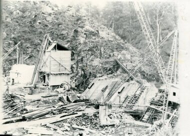
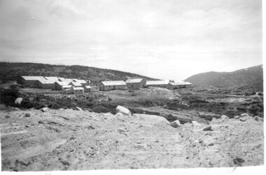
11 Black and White photographs of the Rocky Valley area, c1948
In October 1947 construction was commenced on the erection of the workmen's camp at Rocky Valley. Also in 1947 construction of a stream diversion was commenced to allow excavation to commence for the dam wall. In the summer of 1948/49, stripping of the foundation area on both sides of the river was carried out. Weather conditions were not always favourable during the construction, particularly 1955/56 summer, and work would have to cease each year for the winter season due to the severe conditions. The dam is a earth and rock fill structure with a height of about 30.5 metres and crest length 518.16 metres and was completed in March, 1959.These photographs show the type of terrain in the area prior to the construction and filling of Rocky Valley Dam. Also of interest is the type of accommodation provided for those working on the construction and the early cranes available in the 1940/50's. Of historical importance to understand the conditions in the early construction of the Kiewa Hydro Electric SchemeEleven small black and white photographsPhoto No. 1 - on the back, printed in ink"Rocky Valley - New Mess & offices Dec. 1948". In pencil '14 on the back Photo No. 2 - on the back, printed in ink "Rocky Valley Camp. October 1948". Also stamped on the back "998L" Photo No. 3 -on the back, printed in ink "Rocky Valley Hostel October 1948". Also stamped on the back '998L' Photo No. 4 - on the back, printed in ink "Spion Kopje from bedroom window. October 1948". Stamped on the back '998L'. Photo No. 5 - on the back, printed in ink "Rocky Valley Basin Dec. 1948." In pencil on back, 14. Photo No. 6 - on the back, printed in ink "Site of Wall for Rocky Valley Dam Dec. 1948". In pencil on back, 14. Photo No. 7 - On the back, printed in ink "Commencing of Diversion Tunnel Rocky Valley December 1948". In pencil on back, 14. Photo No. 8 - on the back, printed in ink "One of the two electric cranes at Rocky Valley December 1948". In pencil on back, 14. Photo No. 9 - on the back, printed in ink "'Rapier' (H.Y.) electric crane Rocky Valley December 1948". In pencil on back, 14 . Photo No. 10 - on the back, printed in ink " Pretty Valley Pump line construction Mt. Cope in Background Nov 1948. Circular stamp with the words 'print by Wilson White Albury' in the circle. Photo No. 11 - on the back, printed in ink "Stringing cable on Ruined Castle October 1948. Same stamp as No. 10. In pencil '31'. rocky valley; pretty valley; ruined castle; bogong high plains; kiewa hydro electric scheme -
 Kiewa Valley Historical Society
3 small black and white photos of West Kiewa River and Tail Race, c1948/49
The No. 4 Tail Race Tunnel was commenced in 1947 from the downstream end at Mt. Beauty. Difficulties were encountered and driving from the top end in a downstream direction was commenced in January 1950 and the breakthrough between these two headings occurred on 22d July.Historical record of the construction of the Kiewa Hydro Electric Scheme.3 small black and white photographsPhoto 1 - on back in ink - 'Tour of area, crossing West Kiewa Branch Jan. 1949 Photo 2 - on back in ink - 'Kiewa Valley River - site of tunnel in rear. Dec. 1948'. Photo 3 - on back in ink - 'No. 4 Tail Race Portal Mt. Beauty Jan. 1949'.west kiewa river; tail race portal; mt beauty; kiewa hydro electric scheme -
 Kiewa Valley Historical Society
Photograph - Folder of Photographs (KVHS 1150 A - F) – Photocopied set of black and white photographs from the display folder (pages 1 - 8) put together by KVHS to document life on the Kiewa Valley Hydro-electric Scheme
Although the Kiewa Hydro-Electric Scheme was first proposed in 1911, construction did not commence until 1938. As part of the push to cut electricity costs and diversify supply, the Victorian Government (circa 1930) initiated the conversion from primarily brown coal supply to hydro – electricity. Field investigations during the 1940’s resulted in a new proposal for a scheme that had more than double the capacity of the 1938 scheme. The Kiewa Hydroelectric Scheme became the largest scheme of its kind in the State Of Victoria and the second largest scheme in Australia. The number of personnel involved in the planning and construction of the scheme increased dramatically. During the late 1940’s, most activity centred around the construction of the West Kiewa Power Station, Rocky Valley Reservoir, McKay Creek Power Station and the Bogong Creek Aqueduct.A common thread across all the larger hydro scheme constructions was the need for workers, both qualified and unqualified who came from around the world seeking a new life for themselves and their families. New accommodation and facilities were required for the army of workers engaged in construction in often remote and wild areas. The SEC had a high demand for timber, and set up the first of a number of sawmills at Bogong Creek in 1939 and set up the first hardwood logging in the headwaters of the Kiewa River. These new ‘towns’ such as Mt Beauty and Bogong, survived, serving the needs of operational personnel and their families, and expanding with growth of new industries. Mount Beauty, and to a lesser extent Bogong, are among these places. Large A3 size spiral bound display folder containing 21 of 58 pages of photocopied black and white photographs of various aspects of the early days of the Kiewa Valley Hydro-electric scheme including equipment, various work sites and photographs of workers and their families. 1-Front page; 2-Security gate at Mt Beauty Camp; 3-Channel 1 on East Kiewa River; 4-Junction Dam – Diversion Tunnel Inlet; 5-Sawmill; 6- Homan’s Gap Sawmill; 7 Junction Dam: 8-Homan Dam Site-Diamond Drilling on River Buttress; 9- Homan Dam Site View Upstream 10-Homan Dam Investigation Camp 1-Windsor & Newton Visual Diary 60 sheet (120 pages) 11’ x 14’ 280 x 356mm 110 GSM Acid Free Drawing Paper 2-1940-Security Gate on Mt Beauty side of Kiewa River bridge. Part of old Mt Beauty camp and mess in background 3- STATE ELECTRICITY COMMISSION OF VICTORIA Date; 11.3.40 Time: 10.30am No K35 Kiewa Hydro Electric Works. Diverting East Kiewa River into Channel Page number 1 4-STATE ELECTRICITY COMMISSION OF VICTORIA Date: 5.4.40 Time: Noon No K58 Kiewa Hydro Electric Works. Junction Dam – Diversion Tunnel Inlet – Normal Flow Page number 2 5- STATE ELECTRICITY COMMISSION OF VICTORIA Date: 19.8.42 Time: 2.30pm No K883 Kiewa Hydro Electric Works. Sawmill – General View Page number 3 6- STATE ELECTRICITY COMMISSION OF VICTORIA Date: 12.1.42 Time: 2.00pm No K540 Kiewa Hydro Electric Works. Homan’s Gap Sawmill – General View Page number 4 7- STATE ELECTRICITY COMMISSION OF VICTORIA Date: 12.1.42 Time: 2.00pm No K540 Kiewa Hydro Electric Works. Junction Dam – General View looking upstream Page number 5 8- STATE ELECTRICITY COMMISSION OF VICTORIA Date: 16.11.45 Time: 10.32amm No K52153 Kiewa Hydro Electric Works Homan Dam Site – Diamond Drilling on River Buttress Page number 6 9-STATE ELECTRICITY COMMISSION OF VICTORIA Date: 15.1.45 Time: 4.10pm No K1781 Kiewa Hydro Electric Works Homan Dam Site – View Upstream Page number 7 10- STATE ELECTRICITY COMMISSION OF VICTORIA Date: 15.1.45 Time: 4.10pm No K1781 Kiewa Hydro Electric Works Homan Dam Investigation Camp 1944 – 1945 Page number 8 secv; kiewa hydro electric scheme; mt beauty; bogong; construction work; -
 Kiewa Valley Historical Society
Photograph - Folder of Photographs – Photocopied set of black and white photographs (pages 9 - 18) from the display folder put together by KVHS to document life on the Kiewa Valley Hydro-electric Scheme
Although the Kiewa Hydro-Electric Scheme was first proposed in 1911, construction did not commence until 1938. As part of the push to cut electricity costs and diversify supply, the Victorian Government (circa 1930) initiated the conversion from primarily brown coal supply to hydro – electricity. Field investigations during the 1940’s resulted in a new proposal for a scheme that had more than double the capacity of the 1938 scheme. The Kiewa Hydroelectric Scheme became the largest scheme of its kind in the State Of Victoria and the second largest scheme in Australia. The number of personnel involved in the planning and construction of the scheme increased dramatically. During the late 1940’s, most activity centred around the construction of the West Kiewa Power Station, Rocky Valley Reservoir, McKay Creek Power Station and the Bogong Creek Aqueduct.A common thread across all the larger hydro scheme constructions was the need for workers, both qualified and unqualified who came from around the world seeking a new life for themselves and their families. New accommodation and facilities were required for the army of workers engaged in construction in often remote and wild areas. The SEC had a high demand for timber, and set up the first of a number of sawmills at Bogong Creek in 1939 and set up the first hardwood logging in the headwaters of the Kiewa River. These new ‘towns’ such as Mt Beauty and Bogong, survived, serving the needs of operational personnel and their families, and expanding with growth of new industries. Mount Beauty, and to a lesser extent Bogong, are among these places. PHYSICAL: Large A3 size spiral bound display folder containing 21 pages of photocopied black and white photographs of various aspects of the early days of the Kiewa Valley Hydro-electric scheme including equipment, various work sites and photographs of workers and their families. 1-Bridge across Tailrace Channel 1946 2-New Mess building, Mt Beauty 3-Homan’s Gap Saw Mill 4- Diamond Drilling Plant – Big Hill 5-Rocky Valley Camp-Mess Building 6-Parlimentary Party at Rocky Valley 7-No.4 Headrace Tunnel 8- Allis-Chalmers Tractor School 9- SECV Heavy Machinery lined up by road 10- No. 5 Raceline – Balasting Track with improvised truck 1-1946 – Bridge across tailrace channel Page number 9 2-New mess building, Mt Beauty 6.4.46 Page number 10 3- STATE ELECTRICITY COMMISSION OF VICTORIA Date: 10.1.47 Time: 11.40am No K2271 Kiewa Hydro Electric Works Homan’s Gap Saw Mill – Rip Saw Page number 11 4- STATE ELECTRICITY COMMISSION OF VICTORIA Date: 5.10.47 Time: 11am No K4111 Kiewa Hydro Electric Works Diamond Drilling Plant – Big Hill Page number 12 5- STATE ELECTRICITY COMMISSION OF VICTORIA Date: 11.2.48 Time: 3pm No K4277 Kiewa Hydro Electric Works Rocky Valley Camp-Mess Building Page number 13 6- STATE ELECTRICITY COMMISSION OF VICTORIA Date: 15.4.48 Time: 4.30pm No K4397 Kiewa Hydro Electric Works Parlimentary Party at Rocky Valley Page number 14 7- STATE ELECTRICITY COMMISSION OF VICTORIA Date: 22.8.48 Time: 9am No K4668 Kiewa Hydro Electric Works General view of No.4 Headrace Tunnel Page number 15 8-STATE ELECTRICITY COMMISSION OF VICTORIA Date: 5.9.49 Time: 10am No K5180 Kiewa Hydro Electric Works Allis-Chalmers Tractor School – HD 19, Mr I Crossthwaite at Controls Page number 16 9- No markings Page number 17 10- STATE ELECTRICITY COMMISSION OF VICTORIA Date: 7,12.49 Time: 4pm No K5423 Kiewa Hydro Electric Works No. 5 Raceline – Balasting Track with improvised truck. Page number 18 secv; kiewa hydro electric scheme; mt beauty; bogong; construction area -
 Kiewa Valley Historical Society
Photograph - Folder of Photographs – Photocopied set of 10 black and white photographs (pages 19 - 28) from the display folder put together by KVHS to document life on the Kiewa Valley Hydro-electric Scheme
Although the Kiewa Hydro-Electric Scheme was first proposed in 1911, construction did not commence until 1938. As part of the push to cut electricity costs and diversify supply, the Victorian Government (circa 1930) initiated the conversion from primarily brown coal supply to hydro – electricity. Field investigations during the 1940’s resulted in a new proposal for a scheme that had more than double the capacity of the 1938 scheme. The Kiewa Hydroelectric Scheme became the largest scheme of its kind in the State Of Victoria and the second largest scheme in Australia. The number of personnel involved in the planning and construction of the scheme increased dramatically. During the late 1940’s, most activity centred around the construction of the West Kiewa Power Station, Rocky Valley Reservoir, McKay Creek Power Station and the Bogong Creek Aqueduct.A common thread across all the larger hydro scheme constructions was the need for workers, both qualified and unqualified who came from around the world seeking a new life for themselves and their families. New accommodation and facilities were required for the army of workers engaged in construction in often remote and wild areas. The SEC had a high demand for timber, and set up the first of a number of sawmills at Bogong Creek in 1939 and set up the first hardwood logging in the headwaters of the Kiewa River. These new ‘towns’ such as Mt Beauty and Bogong, survived, serving the needs of operational personnel and their families, and expanding with growth of new industries. Mount Beauty, and to a lesser extent Bogong, are among these places. Large A3 size spiral bound display folder containing 21 pages of photocopied black and white photographs of various aspects of the early days of the Kiewa Valley Hydro-electric scheme including equipment, various work sites and photographs of workers and their families. 1-Allis Chalmers Tractor School 2- Gardens outside Administrative Office – Mt Beauty 3- Mt Beauty house – 1950 4-Bridge over Pretty Valley River, Bogong 5-Rocky Valley Spillway Tunnel break through 6-Ni 1 Headrace Tunnel drilling face 7-No 4 Power Station Drilling 8-Clover Dam Flood Waters 9-No1 Head Race Tunnel Portal Building 10-Clover Dam 1-STATE ELECTRICITY COMMISSION OF VICTORIA Date: 5.9.49 Time: 10amm No K5174 Kiewa Hydro Electric Works Allis Chalmers Tractor School Page number 19 2-STATE ELECTRICITY COMMISSION OF VICTORIA Date: 22.2.50 Time: 3.30pm No K5601 Kiewa Hydro Electric Works Gardens outside Administrative Office – Mt Beauty Page number 20 3-Mt Beauty house – 1950 Page number 21 4-STATE ELECTRICITY COMMISSION OF VICTORIA Date: 23.10.50 Time: 11.15am No K6331 Kiewa Hydro Electric Works Bogong-Bridge over Pretty Valley River Page number 22 5-STATE ELECTRICITY COMMISSION OF VICTORIA Date: 23.6.50 Time: 2.30pm No K5844 Kiewa Hydro Electric Works ROCKY VALLEY SPILLWAY TUNNEL BREAK THROUGH Page number 23 6-20/3/52 – No. 1 Headrace Tunnel Drilling face (E.E.E. contract) Page number 24 7-6/6/52 – No 4 Power Station – Drilling Page number 25 8-STATE ELECTRICITY COMMISSION OF VICTORIA Date: 6/6/52 Time: No K7113 Kiewa Hydro Electric Works Clover Dam Flood Waters Page number 26 9-STATE ELECTRICITY COMMISSION OF VICTORIA Date: Oct 1952 Time: No K7239 Kiewa Hydro Electric Works No. 1 HEAD RACE TUNNEL PORTAL BUILDING. Handwritten underneath – This information from Ron White-the later Principal Hydro Engineer of the SEC. Oct 1952 Location incorrect? All work on No 1 had ceased after financial crash of 1951. This photo would refer to No 4 Headrace Tunnel? Page number 27 10-STATE ELECTRICITY COMMISSION OF VICTORIA Date: Jan 1953 Time: No K7307 Kiewa Hydro Electric Works CLOVER DAM Page number 28 secv; kiewa hydro electric scheme; bogong; mt beauty; construction area