Showing 302 items
matching the proclaimers
-
 City of Greater Bendigo - Civic Collection
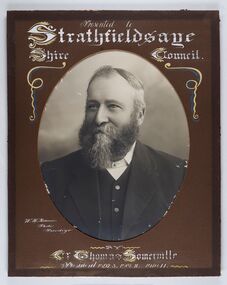
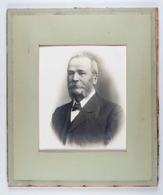
Photograph - Portrait of Councillor Thomas Somerville, W H Robinson
The district of Strathfieldsaye was proclaimed in 1861 and named a Shire on the 17th September in 1866. It remained a shire until amalgamation in 1994 when it became part of the City of Greater Bendigo. The shire was located 8 km to the south- east of Bendigo and covered an area of 601 square kilometres and extended from the Calder Highway to the Coliban and Campaspe Rivers. The shire's administration centre was in Strathfieldsaye until 1972 when new offices were opened in KenningtonFramed black and white head and shoulder portrait of Councillor Somerville with hand drawn detail. Profile slightly to left, face has full beard. Cut oval brown mount decorated with text and scrolls. Hand written title top and lower centre.Presented to / Strathfieldsaye / Shire Council / W. H. Robinson / Photo / Bendigo / by / Cr Thomas Somerville / President 1892 - 3. 1901.2. 1910.11 strathfieldsaye shire council, councillor somerville, president of strathfieldsaye shire -
 City of Greater Bendigo - Civic Collection
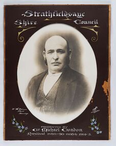
Photograph - Portrait of Councillor Michael Condon, W H Robinson
The district of Strathfieldsaye was proclaimed in 1861 and named a Shire on the 17th September in 1866. It remained a shire until amalgamation in 1994 when it became part of the City of Greater Bendigo. The shire was located 8 km to the south- east of Bendigo and covered an area of 601 square kilometres and extended from the Calder Highway to the Coliban and Campaspe Rivers. The shire's administration centre was in Strathfieldsaye until 1972 when new offices were opened in KenningtonFramed black and white head and shoulder portrait of Councillor Condon with hand coloured and drawn detail. Profile slightly to left. No facial hair. Cut oval brown mount decorated with text, scrolls and flowers. Hand written title top and lower centre.Strathfieldsaye / Shire / Council / W. H. Robinson / Photo / Bendigo / JMB Gribble / Presented by / Cr Michael Condon / President 1889 - 90. 1895-6. 1904 - 5strathfieldsaye shire council, president of strathfieldsaye shire, councillor condon -
 City of Greater Bendigo - Civic Collection
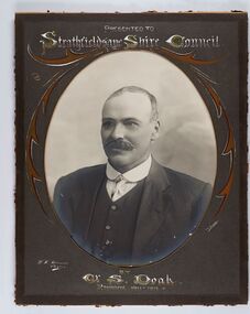
Photograph - Portrait of Councillor Doak, W H Robinson
The district of Strathfieldsaye was proclaimed in 1861 and named a Shire on the 17th September in 1866. It remained a shire until amalgamation in 1994 when it became part of the City of Greater Bendigo. The shire was located 8 km to the south- east of Bendigo and covered an area of 601 square kilometres and extended from the Calder Highway to the Coliban and Campaspe Rivers. The shire's administration centre was in Strathfieldsaye until 1972 when new offices were opened in Kennington.Framed black and white head and shoulder portrait of Councillor Doak with hand coloured and drawn detail. Left facing profile with walrus moustache. Cut oval brown mount decorated with text and scrolls. Hand written title top and lower centre.Presented to / Strathfieldsaye Shire Council / W. H. Robinson / Photo / JMB Gribble / by Cr S. Doak / President 1911 - 1912strathfieldsaye shire council, president of strathfieldsaye shire, councillor doak -
 City of Greater Bendigo - Civic Collection
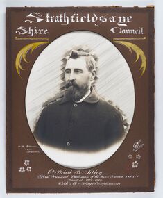
Photograph - Portrait of Councillor Sibley, W H Robinson
The district of Strathfieldsaye was proclaimed in 1861 and named a Shire on the 17th September in 1866. It remained a shire until amalgamation in 1994 when it became part of the City of Greater Bendigo. The shire was located 8 km to the south- east of Bendigo and covered an area of 601 square kilometres and extended from the Calder Highway to the Coliban and Campaspe Rivers. The shire's administration centre was in Strathfieldsaye until 1972 when new offices were opened in KenningtonFramed black and white head and shoulder portrait of Councillor Sibley with hand coloured and drawn detail. Profile slightly to left with walrus moustache and beard. Cut oval brown mount decorated with text, flowers and scrolls. Hand written title top and lower centre.Strathfieldsaye / Shire Council / W m Robinson / Photo / Bendigo / J N B Gribble / Cr Robert R Sibley / First President Chairman of the Road Board 1865 - 5 / President 1866 - 1869 / With Mrs Sibley's Complimentsstrathfieldsaye shire council, councillor sibley, president of strathfieldsaye shire -
 City of Greater Bendigo - Civic Collection
Photograph - Portrait of Councillor Long, Talma & Co
The district of Strathfieldsaye was proclaimed in 1861 and named a Shire on the 17th September in 1866. It remained a shire until amalgamation in 1994 when it became part of the City of Greater Bendigo. The shire was located 8 km to the south- east of Bendigo and covered an area of 601 square kilometres and extended from the Calder Highway to the Coliban and Campaspe Rivers. The shire's administration centre was in Strathfieldsaye until 1972 when new offices were opened in Kennington.Framed black and white head and shoulder portrait of Councillor Long. Profile to left with walrus moustache and mutton chops. Cut olive retangle mount. Verso; Long. On under board which has photograph attached; Talma & Co. / 119 Swanston St., / Melbournestrathfieldsaye shire council, councillor long -
 City of Greater Bendigo - Civic Collection
Photograph - Portrait of Councillor Hargraves, Bartlett Bros
The district of Strathfieldsaye was proclaimed in 1861 and named a Shire on the 17th September in 1866. It remained a shire until amalgamation in 1994 when it became part of the City of Greater Bendigo. The shire was located 8 km to the south- east of Bendigo and covered an area of 601 square kilometres and extended from the Calder Highway to the Coliban and Campaspe Rivers. The shire's administration centre was in Strathfieldsaye until 1972 when new offices were opened in KenningtonFramed black and white head and shoulder portrait of Councillor Hargraves. Profile slightly to right with walrus moustache. Cut rectangle brown mount decorated with coloured text and scrolls. Hand written title top and lower centre.Strathfiledsaye Shire Council / Cr John Hargreaves / President 1919 - 20 1928 - 29 / Presented by his Wife & Familystrathfieldsaye shire council, president of strathfieldsaye shire, councillor hargreaves -
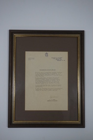 Vision Australia
Letter - Object, White Cane Day Proclamation
In 1964 the first White Cane Safety Day was proclaimed in the United States, to recognise the white cane as a method of independence for blind people and increase awareness by motorists to pay extra consideration to white cane users. Since then the recognition of White Cane Day has spread around the world including Asia, Africa and Europe. In Australia, Queensland was the first state to celebrate White Cane Day in 1978, followed by Victoria in 1979.Typewritten letter in brown frameOn the back: This proclamation of October 15, each year, as White Cane Day throughout the State of Victoria, was made by the Premier of Victoria, the Honourable R.J. Hamer as the result of a deputation by blind people from the Association for the Blind on Thursday October 12th, 1978.rupert hamer, association for the blind, white cane day -
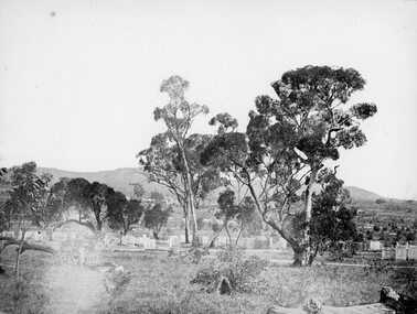 Stawell Historical Society Inc
Photograph, Pleasant Creek Cemetery 1866
Pleasant Creek Cemetery. Part of a collection of Photographs by Mr. O.G. Armstrong as commissioned by the Shire of Stawell for the Inter-colonial and Paris Exhibition in Melbourne in 1866. The site of the Pleasant Creek Cemetery was proclaimed on October the 14th, 1861. Prior to that, a cemetery existed on ‘One Tree Hill’ where burials were made as early as 1854. A memorial is located on the site of the One Tree Hill Cemetery, corner of Griffith and Leslie streets, Stawell West. stawell -
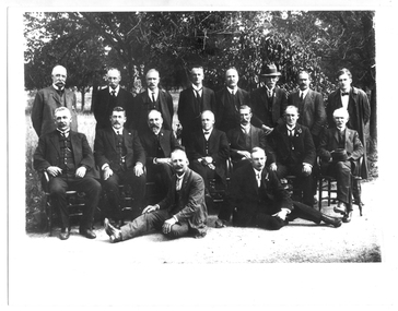
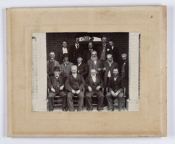 City of Greater Bendigo - Civic Collection
Photograph - Strathfieldsaye Councillor Group Portrait, D.G. Coope & Son - Framers
The district of Strathfieldsaye was proclaimed in 1861 and named a Shire on the 17th September in 1866. It remained a shire until amalgamation in 1994 when it became part of the City of Greater Bendigo. The shire was located 8 km to the south- east of Bendigo and covered an area of 601 square kilometres and extended from the Calder Highway to the Coliban and Campaspe Rivers. The shire's administration centre was in Strathfieldsaye until 1972 when new offices were opened in Kennington.Silver gelatin framed photographic group portrait of fifteen men taken in the alcove of the Strathfieldsaye Shire Hall. Four men are seated and eleven are standing. Photograph is attached directly to cream mount card. Handwritten note with photograph: 1/ John Burke, 2/ (?), 3/ (?), 4/ RHS Abbott, 5/ M Brennan, 6/(?) 7/(?) 1/. M Condon? 2/ (?) 3/ M Burns, 4/(?) Gentlemen at back are probably council staff.shire of strathfieldsaye, strathfieldsaye shire council, president of strathfieldsaye shire, councillor john burke, councillor r.h.s. abbott, councillor brennan, councillor condon, councillor m burns -
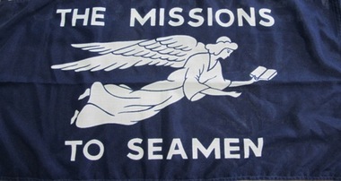 Mission to Seafarers Victoria
Flag, George Tuttill Ltd, THE MISSIONS TO SEAMEN, 20th C
The Mission adopted, as its symbol, a flying angel inspired by a verse from the Book of Revelation (14:60) “Then I saw a flying angel in mid-heaven, with an eternal gospel to proclaim to those on earth, to every nation and tribe, language and people” The incorporated name of the Mission changed in 2000 and became the Mission to Seafarers, Victoria, the logo was also re-designed.This flag was most likely issued by the Central Mission in the UK or possibly ordered from Australia .Flag or banner white printed on dk blue open weave 'scrim' flag with tough woven white nylon hem at left edge whit incoporates a woven length as tie and a wooden peg to secure to flagpole hoist cord.Features a white winged flying angel with outstretched arms, one hand holding an open book with lettering above and below ( see title details).See image; also on verso small red label secured to back of white hem edge with woven details of maker: (Tuttill...) see detail image.mission to seamen, mission to seafarers, flag, flying angel -
 Learmonth and District Historical Society Inc.
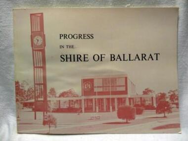
Book, PROGRESS IN THE SHIRE OF BALLARAT, !963
In 1963 the Shire of Ballarat celebrated its Centenary. This book outlines the history and development of the Shire over the 100 years.Councilor Charles Edward (Ted) Brown was at the time Shire President.The District Roads Board was created on 7th October 1856 and on 24th November 1863 was proclaimed a Shire,thus making it the first Shire in Victoria. The book was compiled by James Mitchell(Shire Secretary) and the staff of the Shire of Ballarat and printed by local printers Waller and Chester.Celebrating 100 years of the Shire of Ballarat.A rectangular shaped book (landscape shape).Pale pink background on which is the title in black and,in shades of deeper pink, a photograph of the new Shire Office building and Clock tower in WendoureePROGRESS IN THE SHIRE OF BALLARAT.district roads board 1856.ballarat shire 1863 -
 Flagstaff Hill Maritime Museum and Village
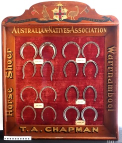
Memorabilia - Horseshoe Case, 1906 – 1907
The horseshoes in this purpose-built display case were made by Thomas Alfred Chapman in 1906-1907. Chapman operated a blacksmith’s shop in Mortlake Rd, Purnim, about 15 mins drive from Warrnambool. Chapman made this horseshoe case especially for the 3rd Exhibition of Australian Manufacturers and Products, held in the Exhibition Building in Melbourne, which was organised and promoted by the Australian Natives Association (ANA). Reference is made to the horseshoe case in the Exhibition’s Souvenir Catalogue of 1907 on page 85, under the heading 'In the Machinery Section the following exhibits are also shown … 'CHAPMAN, T.A. , Woolsthorpe, via Warrnambool, Case of Horseshoes'. The Australian Natives’ Association (ANA) were a non-partisan and non-sectarian, friendly society founded in Melbourne, Australia in April 1871. It was set-up for the benefit of Australian-born white men, and membership was restricted exclusively to that group. Men of other races including the Chinese and Indigenous people were not allowed to join. The ANA had relatively progressive views on women (for the time) and attracted suffragists seeking support for their cause, and in 1894, the ANA advocated for women’s enfranchisement. Although, white women were only admitted as members from 1964. The organisation was most prominent in Victoria and sought to shape Australia’s national identity and was a training ground for businessmen, trade unionists and politicians including many of Australia’s early prime ministers such as Edmund Barton, Alfred Deakin, James Scullin and Francis Forde, and the first Australian-born governor-general, Isaac Isaacs, was a member. By 1910 it had developed into a nationwide association with real political and social influence, and members would participate in many activities. The ANA lobbied strongly for anti-Chinese legislation and were an ardent believer of colonial unification. Its mission and efforts are largely credited for the successful referendums that resulted in Federation of the six Australian colonies into a new nation, the association’s most important legacy. The ANA was also a supporter of trade protection, and were a staunch advocate of the first act of Australia's new parliament, the Immigration Restriction Act 1901 (cth) or commonly known as the White Australia Policy, which became one of the central pillars of Australian nationalism in the 20th-century. The ANA campaigned against the Australian Federal Government's new immigration policy after the Second World War (non-British immigration from southern and central Europe) in order to maintain a 'white Australia', and resisted changes when the Labor government during the 1970s fully dismantled and abandoned the White Australia Policy. The ANA merged with Manchester Unity Independent Order of Oddfellows, in 1993 to become Australian Unity Ltd. The display case of horseshoes changed hands several times, going from its maker Thomas Chapman to his mother then various other members of his family. The case was also displayed at the Lee Family’s butcher shop at 188 Liebig St Warrnambool, and in the Purnim Hotel during the Warrnambool May Races. In the late 1950s the horseshoe case went to Thomas’s son, Brian. He was a Master Farrier and completed his apprenticeship at Flemington Racecourse, and in Warrnambool he owned a blacksmith business at the Warrnambool Racecourse Grounds. Brian later operated a blacksmith’s at Flagstaff Hill, where his customers would bring their horses to be shod. Brian passed away in August 2017. The horseshoe case is significant as an example of trades in the early 20th century in Western Victoria, Australia. It is also significant as an example of horseshoes from the early 20th century. The horseshoe display case is also significant for its association with the Australian Exhibition of 1907, showcasing Australian produce and manufacturing to the world. The horseshoe display case is locally significant for its association with local families, essential businesses and community events. Display case of homemade horseshoes. Wooden case with glass front containing 16 horse shoes grouped in sets, each set with a label: Made 1906-1907 for Australian Exhibition of 1907 by Thomas Alfred Chapman of Warrnambool. The case contains (a) complete chrome set each of Trotting Shoes, Hunting Shoes and Racing Plates, and (b) one pair of Hind Polo Shoes and one pair of Front Aluminium Shoes. The wooden frame has gold lettering on each side proclaiming “Australian Natives Association, T.A. Chapman, horse shoer, Warrnambool” and is topped by a painted Australian coat of arms. Gold lettering on frame, in the order of top/bottom/ left/right “AUSTRALIAN.NATIVES.ASSOCIATION / T.A. CHAPMAN / Horse Shoer / Warrnambool”flagstaff hill, warrnambool, shipwrecked coast, maritime museum, shipwreck coast, horseshoe display case 1906-1907, chromed set of trotting shoes 1906-1907, chrome set of hunting shoes 1906-1907, chrome set of racing plates 1906-1907, pair of hind polo shoes 1906-1907, pair of front aluminium shoes 1906-1907, australian exhibition 1907, australian natives association (ana), t.a. chapman horse shoer warrnambool, thomas alfred chapman, brian chapman, brian “snacks” chapman, blacksmith warrnambool, warrnambool may races, warrnambool racecourse, purnim hotel, lee family’s butcher shop warrnambool -
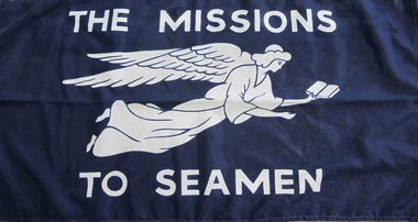 Mission to Seafarers Victoria
Flag - Flying Angel Flag, George Tuttill Ltd, The Missions to Seamen, 20th C
Founded in 1856, the Mission adopted, as its symbol, a flying angel inspired by a verse from the Book of Revelation (14:60) “Then I saw a flying angel in mid-heaven, with an eternal gospel to proclaim to those on earth, to every nation and tribe, language and people” The incorporated name of the Mission changed in 2000 and became the Mission to Seafarers, Victoria, the logo was also re-designed.This flag was most likely issued by the Central Mission in the UK or possibly ordered from Australia .This flag shows a former design of the Flying Angel carrying a Bible and the former name of the organisation before it was changed in 2000 to Mission to Seafarers. Flag or banner white printed on dk blue open weave 'scrim' flag with tough woven white nylon hem at left edge whit incoporates a woven length as tie and a wooden peg to secure to flagpole hoist cord.Features a white winged flying angel with outstretched arms, one hand holding an open book with lettering above and below ( see title details).See image; also on verso small folded black label secured to back of white hem edge with woven details of maker: (Tuttle...) see detail image.flag, flying angel, bible -
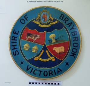 Sunshine and District Historical Society Incorporated
Plaque, A. H. Walker, COAT OF ARMS - Shire of Braybrook Victoria, Unknown date of manufacture
From around circa 1850 Braybrook was already well established and became a staging point for prospectors on their way to the diggings. Local government for this rural area to the west of Melbourne came when the BRAYBROOK ROAD DISTRICT was proclaimed on 28 May 1860. This authority was superseded on 23 January 1871 with the formation of the SHIRE OF BRAYBROOK. The Shire of Braybrook existed for about 80 years during which time it experienced significant industrial growth. The Shire of Braybrook ceased to exist in 1951 when the CITY OF SUNSHINE was formed.The Coat of Arms informs the observer that the Shire of Braybrook was initially a rural area with its images of a cow, sheep, and hay. The reference to industry however probably does not indicate adequately the large growth in industrial activity that occurred within the Shire. Circular board of Masonite painted by A. H. Walker which is a true depiction of the Coat of Arms for the Shire of Braybrook. It is mainly blue, yellow and red coloured with black writing, and has images of a cow, sheep, and hay, and also indicates a reference to industry.Shire of Braybrook Victoria / Dieu Et Mon Droit / By Industry / A. H. Walkercoat of arms, shire of braybrook, a. h. walker, plaque, sunshine -
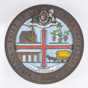 City of Greater Bendigo - Civic Collection
Sign - Shire of Strathfieldsaye Coat of Arms
The district of Strathfieldsaye was proclaimed in 1861 and named a Shire on the 17th September in 1866. It remained a shire until amalgamation in 1994 when it became part of the City of Greater Bendigo. The shire was located 8 km to the south- east of Bendigo and covered an area of 601 square kilometres and extended from the Calder Highway to the Coliban and Campaspe Rivers. The shire's administration centre was in Strathfieldsaye until 1972 when new offices were opened in Kennington. This coat of arms was commissioned for the front of the shire hall building.Brass painted coat of arms or emblem within a circle of the Shire of Strathfieldsaye. Outer rim contains text: SHIRE OF STRATHFIELDSAYE VICTORIA 1866 with the shield of the monarch of the United Kingdom centre top. The shield is divided into four parts with images reflecting the leading industries of the time; wine growing, mining, farming and tanning. The motto PROGRESS is depicted lower centre of shield. SHIRE OF STRATHFIELDSAYE / VICTORIA / 1866 / PROGRESSshire of strathfieldsaye, city of greater bendigo amalgamation, city of greater bendigo signs -
 Tarnagulla History Archive
Photograph of group of men, probably Shire of Bet Bet Council, circa 1920s, circa 1920s
Murray Comrie Collection. This photograph taken after the amalgamation with the Borough of Tarnagulla Council in 1915. Middle row, fourth from left is Walter (Wattie) Corrie, the Tarnagulla Baker, fourth from left is James Duggan, Tarnagulla Agent. Shire of Bet Bet Proclaimed Sept 20, 1864 Re-defined Feb 10, 1891 Tarnagulla Borough united Oct 1915 Dunolly Borough united Nov 1, 1921 Re subdivision from 5 to 3 ridings Oct 1952Monochrome photograph of a group of men assembled in rows for a photograph. No caption or explanation accompanies photograph. Probably depicts members of the Shire of Bet Bet Council in the 1920s. Location and names unknown. Walter Martin is sitting in the middle of the middle row. He was the Tarnagulla baker at the time of the photo. To the right of him in the photo is James Duggan, Tarnagulla dealer and agent. tarnagulla, council, bet bet shire, local government, councillors, mayor, shire -
 Bendigo Historical Society Inc.
Document - SEDGWICK INFORMATION
Document, Sedgwick, was known as Upper Emu Creek until 1901. It is located ten miles south of Bendigo in hilly sedimentary and granite country.The first freehold grants were taken up in 1854. In 1861 the Strathfieldsaye Road District was Proclaimed. Five years later it became the Shire of Strayhfieldsaye.Mining west of the Axe Creek commenced in 1863. Agriculture, farmers made modest livings from vineyards, orchards,dairy cattle, eggs and tomatoes. The Osborne family had seventy acres planted to apples. Prior to 1934 Favaloros collected cream from district farms, then fresh milk in cans was carted to Bendigo until 1970.document, sedgwick -
 Wodonga & District Historical Society Inc
Sign - 2 Victorian State Shields from the Wodonga Court house
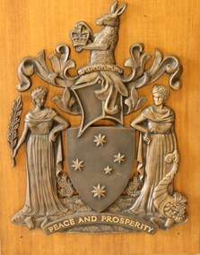
The Royal Warrant assigning the Armorial Bearings to Victoria was signed on the 6th June, 1910 by King George V. The motto Peace and Prosperity was the first to be in English among the Arms of any Public Authority in Australia. In 1958 the Pink Heath was proclaimed as the floral emblem of Victoria. This led to a request to have it included somewhere in the Armorial Ensigns of the State. The solution was to have the plant shown growing from a grassy mound. On the 28 March 1973 Queen Elizabeth II signed a further Royal Warrant which added the mound. This shield is the official emblem of the State of Victoria. It can only be displayed in limited place such as Law Courts and Victorian Government offices with permission of the Victorian Government.2 Victorian Coat of Arms from the Victorian State Government offices in Wodonga. The kangaroo at the top holds a crown. The shield also features the Southern Cross. Two female figures represent Peace and Prosperity. The figure on the left wears a laurel wreath crown and carries a sprig of olive in her hand, representing Peace. The other figure wears a crown of golden cereal and holds the horn of cornucopia, representing abundance or Prosperity. The first one is mounted on a wooden, varnished board.At the bottom of each shield "'PEACE AND PROSPERITY"shield, heraldry, victorian state government -
 Wodonga & District Historical Society Inc
Functional object - Wodonga Council Official Seals
Wodonga Shire was created in 1876 when the colonial government agreed to ratepayers' petitions to have their part of the local government district severed from the Yackandandah Shire to form a new municipality. In March 1973 Wodonga was declared as the first Rural City in Australia. This was officially proclaimed by the Governor of Victoria, Sir Rohan Delacombe at an open-air ceremony in Hovell Street following a procession along High Street led by the Victorian Police Band. The first meeting of the Council was held in the open air immediately after the Proclamation.These Seals are significant because they document different stages in the development of local government in Wodonga.Two wood and metal seals to endorse documents. The seal with black painted handle is for the Rural City of Wodonga. The brown handled seal is for the Shire of WodongaSeal 1 - Rural City of Wodongawodonga shire council, rural city of wodonga -
 Warrnambool and District Historical Society Inc.
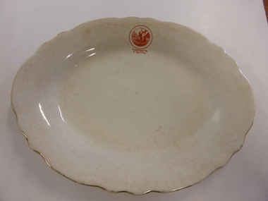
Plate Pottery, Serving Plate Parramatta, Late 19th century
The settlement of Parramatta is one of the earliest inland settlements in Australia being settled in November 1788 just months after the arrival of the First Fleet to Sydney. Originally named Rose Hill it was given the name Parramatta which closely approximated the original Aboriginal name for the area. Being within a reasonable distance to the settlement of Sydney and in an area of fertile soil, it soon became a successful farming region. It was proclaimed a city in 1938. This plate possibly belongs to either the commemoration of 100 or 150 years of settlement of the area, although the stamp on the plate is the same drawing as that on the official invitation for 1938While this plate has no local historical links , it does have significance belonging to one of the earliest settlements in Australia.White oval plate with fluted edge with gold on rim. Small orange stamp on one edge.Parramatta 2 Nov 1788 on one edge of plate. Stamp on back: Grimwades Staffordshire England Upper Hanley Pottery. Semi porcelainwarrnambool, parramatta, serving plate -
 Bayside Gallery - Bayside City Council Art & Heritage Collection
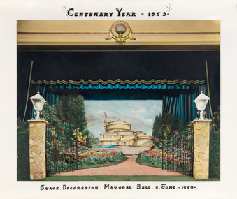
Photograph - hand-coloured photograph, Brighton Centenary Year, Stage decoration, Mayoral Ball, c. 1959
This work was presented to The Mayor and Mayoress, Cr. and Mrs R.G. Ward, by the citizens of Brighton to commemorate the Brighton Centenary in 1959. Brighton was first incorporated as a borough on 18 January 1859, it became a town on 18 March 1887 and was proclaimed a city on 12 March 1919. The new Brighton Municipal Offices were designed by Kevin Knight of Oakley and Parkes with the engineers John Connell and Associates and were erected by Prentice Builders Pty Ltd. The foundation stone was laid on 13 February 1959 and the building was opened on 21 July 1961. The interior decoration and furniture was by Grant Featherston.brighton centenary, brighton town hall, stage decoration, mayoral ball, brighton municipal offices, civic centre, oakley and parkes, kevin knight, r.g. ward, mayor -
 Vision Australia
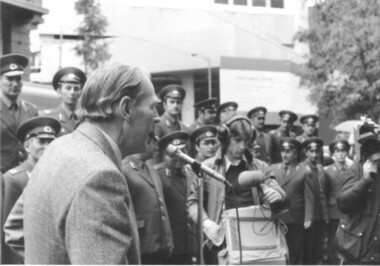
Image, 15/10/1979
October 15, 1979 was the very first publicly proclaimed White Cane Day in Victoria. Announced by Premier Hamer, onlookers were invited to learn more about the various societies in Victoria that assisted the blind and vision impaired. Barry Humphries was the guest of honour, and spoke with a small group before venturing out with his own white cane to test out Melbourne’s wet streets. Caravans were set up along Swanston Street to distribute information. The RAAF band played and a square dance exhibition was held by vision impaired dancers in Bourke Street. 13 B/W photographs w/ 20 negatives and 23 col. negativesOn the back of BRIP381.11 is a partially erased pencil description 'Kathy Zwald' and 'Doris Nothling".white cane day, barry humphries, doris nothling, kathy zwald -
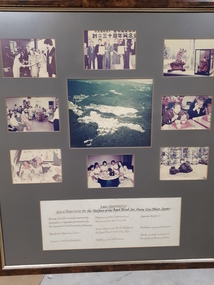 Vision Australia
Image, Seimei Association for the Welfare of the Aged Blind Inc., Oume City, Tokyo, Japan, 1985
Nine coloured photographs of the residents and surrounds of the Seimei Association for the Welfare of the Aged Blind Inc., Oume City, Tokyo, Japan. A brief description describes the scene: Princess Chichibu-no-miya welcomed by the Australian & Japanese representatives for the sisterhood & 30th Anniversary Ceremonies. Residents Band and Choirs. Origami made by Residents. Displaying sister organisations Proclaimation, 8th June 1985. Seimei Association for the Welfare of the Aged Blind, Oume City, Tokyo. Staff enjoying celebrations. Japanese artefacts. Residents enjoying mealtime. Garden outside entrance and Kotobuki-so Nursing Home.Digital Imageassociation for the blind -
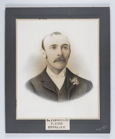 City of Greater Bendigo - Civic Collection
Photograph - Portrait of Councillor Orr, The Yeoman Studios, Ex. Councillor / F. Orr / Eppalock
The district of Strathfieldsaye was proclaimed in 1861 and named a Shire on the 17th September in 1866. It remained a shire until amalgamation in 1994 when it became part of the City of Greater Bendigo. The shire was located 8 km to the south- east of Bendigo and covered an area of 601 square kilometres and extended from the Calder Highway to the Coliban and Campaspe Rivers. The shire's administration centre was in Strathfieldsaye until 1972 when new offices were opened in Kennington. Eppalock Ward is one of three wards in the Greater Bendigo municipality which includes the former Strathfieldsaye Shire. Framed black and white head and shoulder portrait with hand coloured detail. Man with profile slightly to right, walrus moustache, image encircled. Photograph is attached to mount card. Hand written title lower centre.Ex. Councillor / F. Orr / Eppalock / The / Yeoman / Studiosshire of strathfieldsaye, councillor orr -
 Wangaratta RSL Sub Branch
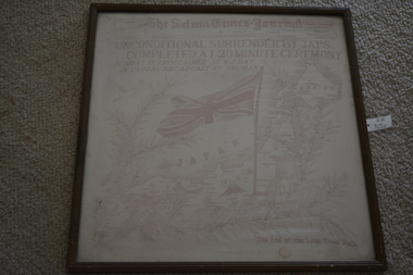
Textile - Framed Silk Scarf, The Selma Times Journal
A WWII silk newspaper front page from The Selma Times Journal, September 2nd 1945, announcing the unconditional surrender by Japs completed at twenty minute ceremony. Sunday is proclaimed as VJ Day in global broadcast by Truman .... The end of the long road back. The Selma Times-Journal is a six-day-a-week newspaper located in Selma, Alabama. It publishes every day of the week except Monday. It is owned by Tuscaloosa, Alabama-based Boone Newspapers Inc. The paper was founded as the Selma Courier on November 2, 1827, by Thomas Jefferson Frow.Brown timber frame containing red and white silk scarf featuring newspaper headline above picture of a flag and map of JapanThe Selma times Journal dated September 2 1945silk scarf, the selma times journal, 2nd september 1945, ww2 -
 City of Moorabbin Historical Society (Operating the Box Cottage Museum)
Photograph, Black & White, J.Redmore "God Cottage' Bentleigh c1890, c1900
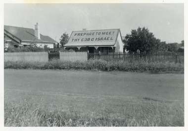
1890 - 1950 This little cottage was located near the corner of Centre Road and Jasper Road East Brighton ( now Bentleigh) between where the Bentleigh RSL and Woolworths Supermarket now stand. Rev.B.Redmore, and his wife, were early members of the Salvation Army Corps, and they went to unusual lengths to proclaim their faith. Texts were hung along the veranda to catch the attention of passers-by and on the iron roof was painted a large sign ' PREPARE TO MEET THY GOD O' ISRAEL' ( The apostrophe is not a misprint.) The Cottage became known locally as The "God Cottage" and was demolished c1950 ( H.Stanley 2005)The 'God Cottage ' with its Biblical texts and large roof sign was an unique feature in East Brighton ( Bentleigh) 1890 - 1950 Black & White photograph showing a small cottage with a large sign painted on the roofBack Handwritten informationredmore reverend b, salvation army, smith j l; smith mary ann, stanley helen, smith vic, chaff cutter, horse drawn carts, toll gates brighton, motor cars 1900, steam engines, early settlers, bentleigh, mckinnon, parish of moorabbin, city of moorabbin, county of bourke, moorabbin roads board, shire of moorabbin, henry dendy's special survey 1841, were j.b.; bent thomas, o'shannassy john, king richard, charman stephen, highett william, ormond francis, maynard dennis, market gardeners, vineyards, orchards -
 Vision Australia
Image, 15/10/1979
October 15, 1979 was the very first publicly proclaimed White Cane Day in Victoria. Announced by Premier Hamer, onlookers were invited to learn more about the various societies in Victoria that assisted the blind and vision impaired. Barry Humphries was the guest of honour, and spoke with a small group before venturing out with his own white cane to test out Melbourne’s wet streets. Caravans were set up along Swanston Street to distribute information. The RAAF Central band played and a square dance exhibition by The Lightfooters (a group ofvision impaired dancers) in Bourke Street. 12 B/W photographswhite cane day, raaf central band -
 City of Greater Bendigo - Civic Collection
Photograph - Portrait of Shire Secretary Brennan, Unknown
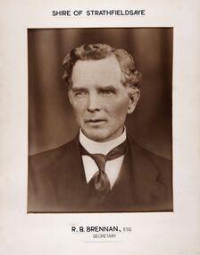
The district of Strathfieldsaye was proclaimed in 1861 and named a Shire on the 17th September in 1866. It remained a shire until amalgamation in 1994 when it became part of the City of Greater Bendigo. The Shire was located 8 km to the south- east of Bendigo and covered an area of 601 square kilometres and extended from the Calder Highway to the Coliban and Campaspe Rivers. The shire's administration centre was in Strathfieldsaye until 1972 when new offices were opened in Kennington. Secretary Brennan, son of Councillor M. Brennan was appointed after his fathers death to the role and according to the The Bendigo Independent was in the role in 1917. See References.Framed black and white head and shoulder portrait of Councillor Brennan. Profile slightly to left. Cut rectangle cream mount. Hand written title top and lower centre. Shire of Strathfieldsaye / R. B. Brennan, Esq / Secretarystrathfieldsaye shire council, secretary strathfieldsaye shire -
 Kew Historical Society Inc
Clothing - Silk Organza Wedding Dress, Oggi Fashion House, 1971
Fashion by Oggi, as the sign above the door proclaimed, was located at the Paris End of Collins Street, on the south side, virtually opposite Lilian Weightman’s Le Louvre boutique. Janet Brock, who at the time was working in the Central Business District of Melbourne, had stopped to admire a mauve version of the dress that was displayed in the window, and, on making inquiries from the proprietress, ordered a made-to-measure cream-coloured copy. Her marriage occurred shortly after the death of her father, and took place on 18 December 1971 at the Kew Presbyterian Church in Cotham Road, where the Rev. Peter Mackie was the celebrant. The Fashion & Design collection of the Kew Historical Society includes examples of women’s, men’s, children’s and infants’ clothing from the 18th, 19th and 20th centuries. Items in the collection were largely produced for, or purchased by women in Melbourne, and includes examples of outerwear, protective wear, nightwear, underwear and costume accessories.Wedding dress, purchased by Janet Elizabeth Brock in December 1971 from Oggi of Collins Street. The wedding dress, reaching just below the knee, is lined in silk with a double outer layer of organza. The striking decoration of the monochromatic cream dress is achieved through the use of wide ruffled organza frills at the neck, on the sleeves and at the flared hem of the dress. The dress has a discrete v-neckline with small, self-covered buttons at centre front. At the back, the dress is closed with a nylon zip. In addition to the elaborate stiffened frills, the dress features a wide fabric belt with a double bow, worn at the front. oggi - 103-105 collins street - melbourne (vic), women's clothing, wedding dresses, janet (brock) walker, australian fashion - 1970s -
 Glenelg Shire Council Cultural Collection
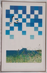
Print, Lawrence Rocks and Point Danger from Crumpets, 1985
Gannet in flight over seascape. The sky is a series of blue and white squares. Under the sky is the sea and an island.Front: 20/25 (lower left, pencil) Lawrence Rocks and Point Danger from Crumpets (lower centre, pencil) P. Tsernjavski 1985 (signature, lower right, pencil) Mayor of Portland (lower left, blue stamp) Portland proclaimed a City October 28th 1985 (lower centre, blue stamp) Minister for Local Government (lower right, blue stamp) Back: Gary Hayman/ Picture Framer (sticker)portland, portland bay, crumpets, lawrence rocks, female artists, female, women artists