Showing 623 items matching "location map"
-
 Marysville & District Historical Society
Photograph (item) - Colour photograph, 03-01-2005
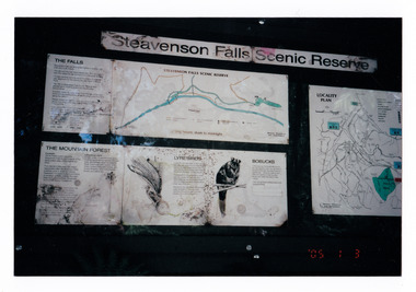
... Scenic Reserve. Shows a map of the reserve, information panels... to the area and a map showing the location of the falls. On the front ...Shows the sign at the Steavenson Falls Scenic Reserve.Shows the sign at the Steavenson Falls Scenic Reserve. This sign was destroyed in the 2009 Black Saturday bushfires. The Steavenson Falls is named after the Victorian Assistant Commissioner of Roads and Bridges, John Steavenson who arrived in Victoria in the early 1860s.'05 1 3 3.01.05. Marysville (from Helga Walsh)steavenson falls, steavenson falls scenic reserve, mountain forest, lyrebird, bobuck, mountain brushtail possum, marysville, victoria, john steavenson, 2009 black saturday bushfires -
 Bendigo Military Museum
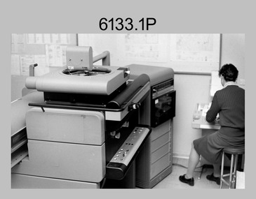
photograph - Orthorectification Equipment - Army Survey Regiment, Fortuna, Bendigo, c1975
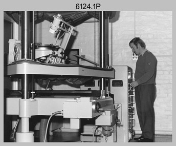
Orthophoto mapping provided the Survey Corps with the capability to produce map products quickly in the event of a crisis. These are four photographs of equipment used by the Army Survey Regiment to produce orthophotomaps. The Wild GZ1 orthophoto projector was introduced in 1973 and was the first equipment used to orthorectify colour and monochrome film aerial photography. Height profiles were originally produced on a PEB8 Stereo profiler and later were software generated. Photos of the PEB8 are available in Victorian Collections item 6222.17P, photos .5P and .6P. In the same era the IBM 1130 computer; OMI/Nistri AP/C-3 analytical plotter with coordinatograph, OP/C orthophoto projector and Zeiss Planimat D2 stereoplotters were introduced. Orthorectification is the process of removing geometric distortions and scale errors/variations from images. Images have tilt and relief distortions that make it difficult to compare accurately a map and an image of the same geographic area. Once an image is orthorectified, features on the image are shown in their planimetric locations. These four photographs of orthorectification equipment were taken at the Army Survey Regiment at Fortuna, Bendigo, c1975. Photo .1P and .3P were printed on photographic paper and scanned at 300 dpi. Photos .2P, .4P and .5P were on 35mm negative film and scanned at 96 dpi. They are part of the Army Survey Regiment’s Collection. .1) - Photo, black & white, c1975, Wild GZ1 orthophoto projector operated by CPL Phil Boyle. .2) - Photo, black & white, c1975, Wild GZ1 orthophoto projector. .3) - Photo, black & white, c1975, Wild GZ1 orthophoto projector. .4) - Photo, black & white, c1978, Zeiss D2 Planimat Stereoplotter. .5) - Photo, black & white, c1978, Zeiss D2 Planimat Stereoplotter..1P to .5P No annotations.royal australian survey corps, rasvy, army survey regiment, army svy regt, fortuna, asr -
 Bendigo Military Museum
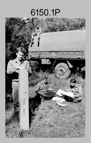
Photograph - Royal Australian Survey Corps Aerial Surveys, c1980
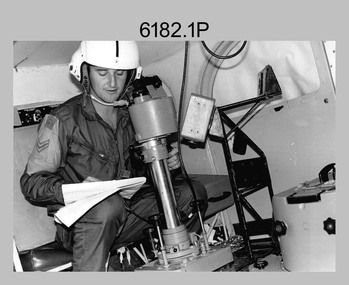
This is a set of nine photographs of technicians from the Royal Australian Survey Corps operating aerial surveys equipment c1980s. In photo .1P, CPL Steve Gloster was operating a RC10 air survey camera mounted in an Australian Army Pilatus Porter aircraft. The Wild RC10 super wide-angle air survey cameras were first introduced in 1971, were equipped with virtual distortion free lenses for supplementary, spot and special photography. In photo .2P, Roger Rees was operating Air Profile Recorder (APR) equipment. it was possibly taken during OP NERVOSE 84, sometime between June – August 1984 when based in Ngukurr, Northern Territory. The APR was operated at this time in unison with an RC10 camera. In 1963 the Royal Australian Survey Corps introduced the radar airborne profile recorder (Canadian Applied Research Ltd, Mark V, Airborne Profiler Recorder) was introduced for 1:100,000 mapping to replace terrain heighting by aneroid barometry. Later in 1974-1975, the Australian developed WREMAPS II airborne laser terrain profile recorder was introduced. In photo .3P, Neil Jones appears at the door of Airsearch Beechcraft Queen Air aircraft, Registration / Serial VH-MWX. This aircraft was typically used by RA Svy on air survey operations flying mission with Aerodist, APR and RC10 camera equipment. The Australian Army’s Pilatus Porter (short take-off and landing turbo propeller) was also equipped with a Wild RC10 aerial mapping camera for identification photography. The Pilatus Porter was also used on RA Svy’s map field checking operations. Photo .9P was taken at a survey station at an unknown location. In this photo an Australian Army Kiowa Light Observation Helicopter (LOH) is supporting a field survey party undertaking Magnavox AN/PRR-14 portable Doppler satellite observations. The satellite receiver’s antenna is plumbed over the survey ground mark surrounded by white plastic panels. The panels were used to identify the survey station on aerial photography. Introduced in 1974–1975, the Magnavox AN/PRR-14 portable Doppler satellite (US Navy Navigation Satellite System – TRANSIT) receivers and computing system provided independent three-dimensional point positions anywhere in the world, anytime, in any weather accurate to about 1.5metres with precise satellite ephemerides. The Bell OH-58 Kiowa LOH was a family of military helicopters used for observation, utility, and direct fire support. It was identified by RA Svy in the mid-1970s that considerable time was lost in replacing unserviceable remote equipment by road. Therefore Aerodist operations (pre-dating satellite receiver operations) were fully supported by Army’s Kiowa LOH aircraft. This is a set of nine photographs of technicians from the Royal Australian Survey Corps operating aerial surveys equipment c1980s. .1P to .3P, .5P to .9P - Colour and black and white photos on photographic paper and scanned at 300 dpi. .4P - Colour photo on 35mm slide film and scanned at 96 dpi. .1) & .2) - Photo, black & white, c1980s, CPL Steve Gloster operating an RC10 air camera. .3) - Photo, colour, 1984, Roger Rees operating Air Profile Recorder (APR) equipment. .4) - Photo, colour, c1980s, Neil Jones at the door of an Airsearch Beechcraft Queen Air aircraft, typically used by RA Svy on air survey operations. .5) - Photo, colour, c1980s. A Beechcraft King Air aircraft, also used by RA Svy on air survey operations. .6) - Photo, colour, c1980s. An Australian Army Pilatus Porter, used by RA Svy on air survey and map field checking operations. SGT Peter Mustart is possibly in the foreground. .7) to .8) - Photo, colour, c1980s. An Australian Army Pilatus Porter and unidentified personnel, used by RA Svy on air survey and map field checking operations. .9) - Photo, colour, c1980s. An Australian Army Kiowa helicopter supporting a field survey party undertaking Magnavox AN/PRR-14 portable Doppler satellite observations. There are biro marks on photos .4P to .9Proyal australian survey corps, rasvy, army survey regiment, asr, fortuna, aerial surveys -
 Bendigo Military Museum
Photograph - Retouching Reproduction Material at the Army Survey Regiment, c1960s, c1970s
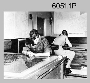
The first four photographs were most likely taken in the 1960 and the fifth in the 1970s at the Army Survey Regiment, Fortuna, Bendigo. As there are no annotations with the photos, the exact dates, locations and names of personnel are unknown. SGT Bob Scaddan appears in the fifth photo taken in the 1970s Photos .1P and .2P. could have been taken in Lithographic Squadron’s retouching room and Photos .3P, .4P and .5P. were probably taken in Cartographic Squadron’s Correcting Section, located in the Attic. Retouching mainly entailed the application of liquid opaque (Plumtree), commonly known as “duff” to cover blemishes such as scratches and spots on film negatives before photographic exposure. Retouching technicians also used specialised techniques such as “needling” to repair faults on the emulsion of map reproduction material. The technician in photo .4P is needling a hydrographic feature on a drainage negative, with a zoom transfer scope projecting a scaled projected aerial photograph as a positional reference. This is a set of five photographs of technicians retouching reproduction material at the Army Survey Regiment, Bendigo. The photographs were printed on photographic paper and are part of the Army Survey Regiment’s Collection. The photographs were scanned at 300 dpi. .1) - Photo, black & white, c1960s. unidentified personnel in Lithographic Squadron. .2) - Photo, black & white, c1960s. unidentified personnel in Lithographic Squadron. .3) - Photo, black & white, c1960s. unidentified personnel in Cartographic Squadron Attic. .4) - Photo, black & white, c1960s. unidentified personnel in Cartographic Squadron Attic. .5) - Photo, black & white, c1970s. SGT Bob Scaddan in Cartographic Squadron..1P to .3P, .5P - annotated “Retouching”royal australian survey corps, rasvy, army survey regiment, army svy regt, fortuna, asr, litho, carto -
 Bendigo Military Museum
Photograph - Orthophotomap Workstation, Lithographic Squadron – Army Survey Regiment, Fortuna, Bendigo, 1988
This collection of four photos was most likely taken at Lithographic Squadron, Army Survey Regiment, Fortuna, Bendigo in 1988. Orthophoto mapping provided the Survey Corps with the capability to produce map products quickly in the event of a crisis. These are four photographs of equipment used by the Army Survey Regiment to produce orthophotomaps. The OR1 orthophoto projector and workstation was introduced in the mid-1980s. It was the second-generation equipment used to orthorectify colour and monochrome film aerial photography, replacing the system introduced in 1973. Orthorectification is the process of removing geometric distortions and scale errors/variations from images. Images have tilt and relief distortions that make it difficult to compare accurately a map and an image of the same geographic area. Once an image is orthorectified, features on the image are shown in their planimetric locations. These four photographs of orthorectification equipment in operation were taken at the Army Survey Regiment at Fortuna, Bendigo, 1988. The photographs were on 35mm negative film and were scanned at 96 dpi. They are part of the Army Survey Regiment’s Collection. .1) to .4) - Photo, black & white, 1988, WILD OR-1 Orthorectification Workstation, SPR Carmel (Butler) Fauth.No personnel are identifiedroyal australian survey corps, rasvy, army survey regiment, army svy regt, fortuna, asr, litho -
 Bendigo Military Museum
Photograph - Lithographic Squadron Regimental Training, Army Survey Regiment, Bendigo, 1989
This is a set of 24 photographs of Army Survey Regiment’s Lithographic Squadron personnel undertaking regimental training in an unknown location in April 1989. The purpose of the training was probably to provide personnel a practical knowledge of navigation and map reading, RATEL and Survival in the Field, vehicle camouflage, teamwork and leadership. The training did not include infantry and minor tactics due to the absence of weapons. Although these photos are not annotated other than the month and year, most personnel are positively identified.This is a set of 24 photographs of personnel from Lithographic Squadron, Army Survey Regiment, Fortuna, Bendigo, undergoing regimental training in April 1989. The photographs were on 35mm negative film and scanned at 96 dpi. They are part of the Army Survey Regiment’s Collection. .1) - Photo, black & white, 1989, background L to R: Frank Lenane, Bill Jones, foreground L to R: Gavin McLean, Colin Yeats, Peter Dillon. .2) - Photo, black & white, 1989, Rhys De Laine. .3) - Photo, black & white, 1989, L to R: Peter Breukel, Colin Yeats. .4) - Photo, black & white, 1989, L to R: Colin Yeats., Peter Dillon. .5) - Photo, black & white, 1989, L to R: Graeme Spong, Gavin McLean, unidentified (x2), Peter Breukel, Steve Burke, Bill Jones, Colin Yeats. .6) - Photo, black & white, 1989, L to R: Graeme Spong, Bill Jones, Colin Yeats, Peter Dillon, Peter Breukel, Steve Burke, Colin Yeats. .7) - Photo, black & white, 1989, L to R: Graeme Spong, Bill Jones, Colin Yeats, Peter Dillon, .8) - Photo, black & white, 1989, Colin Yeats. .9) - Photo, black & white, 1989, L to R: Gavin McLean, Colin Yeats. .10) - Photo, black & white, 1989, L to R: Steve Burke, Peter Breukel, Colin Yeats, unidentified. .11) - Photo, black & white, 1989, L to R: Steve Burke, Peter Breukel. .12) - Photo, black & white, 1989, L to R: Peter Breukel, Steve Burke. .13) - Photo, black & white, 1989, Craig Hersant. .14) - Photo, black & white, 1989, L to R: Rob Bogumil, Darren Maher, Paul Baker, Rob Jones, Shona Hastie, unidentified, Chad Hardwick. .15) - Photo, black & white, 1989, L to R: Chad Hardwick, unidentified, Rob Bogumil, Rob Jones, Darren Maher, unidentified, Paul Baker. .16) - Photo, black & white, 1989, L to R: Rob Bogumil, Darren Maher, Chad Hardwick, Rob Jones, unidentified (x2), Paul Baker. .17) to .22) - Photo, black & white, 1989, unidentified personnel applying camouflage to truck. Shona Hastie in truck, .23) - Photo, black & white, 1989, L to R: LT Dave Weston, LT Craig Hersant, Trevor Osborne, Bill Jones. .24) - Photo, black & white, 1989, L to R: Andrew Arman, unidentified, Peter Dillon, Steve Burke, Colin Yeats, Peter Breukel. No personnel are identified. Annotation dated April 1989.royal australian survey corps, rasvy, army survey regiment, army svy regt, fortuna, asr, litho -
 Lara RSL Sub Branch
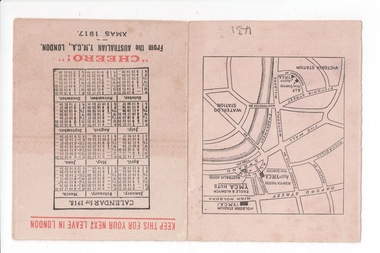
Calendar, Keep This For Your Next Leave In London Calendar for 1918, 1917
... the Australian Y.M.C.A.,London XMAS 1917 The opposite side has a map... side has a map of London showing location of YMCA HQ ...Calendar Card 1918 - Cheerio XMAS 1917 YMCA LondonKeep This For Your Next Leave In London at the top of a Calendar for 1918. Underneath in red "CHEERO!" Next line From the Australian Y.M.C.A.,London XMAS 1917 The opposite side has a map of London showing location of YMCA HQ. and railway stations Inside the card are the addresses of other YMCA's in the London district. calendar, 1917, ymca, map london ymca ww1 -
 Bendigo Military Museum
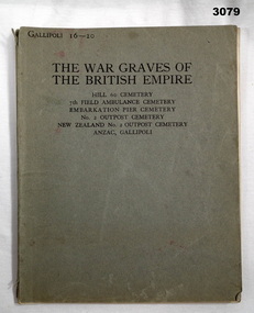
Book - BOOK, WAR GRAVES, Imperial War Graves Commission, The War Graves of the British Empire, Post WW1
Grey cardboard cover with black print on front, 52 white pages with black print. Coloured map of Anzac area inside front cover showing maps of cemeteries with names & plot locations of those buried who fell in the Great War.Inside back cover: “Printed by H M Stationery Office Press - Harrow”books military, memorials - tombstones, war graves -
 Federation University Historical Collection
Map, Central Ballarat Retail and Business Guide, 2003, 07/2003
Map of Central Ballarat Streets, Central Square, Bridge Mall Shopping Centre and Creswick Plaza, with a legend of businesses and locations. scarsdale, grenville, krause, browns and scarsdale, mopianimum, watershed, yarrowee, woady yalloak, timber reserve, department of mines, plans, cgt, crown lands, ferdinand krause -
Federation University Historical Collection
Pamphlet, The Golden Plains Art Trail
... Coloured pamphlet that folds out with a map... with a map of the locations on the Art Trail The Golden Plains Art ...Coloured pamphlet that folds out with a map of the locations on the Art Trailthe golden plains shire, helen lewers, dawn whitehead, edward coleridge-driver, ros lawson, arts trail -
Federation University Historical Collection
Pamphlet, Fletcher and Son Ltd, History on Display
... / Has a map of museum's location, as well as assitional... and historical features/ Has a map of museum's location, as well ...Images and backgrounds histories and historical features/ Has a map of museum's location, as well as assitional information.ballarat historical society, museum -
Frankston RSL Sub Branch
Map, SECRET LANDING GROUNDS AUSTRALIA
Large map of aircraft landing grounds located in Australia and some nearby Islands. This map shows landing grounds in use during the latter years of World War 2. The map is in Mercator Projection to the Equatorial Scale 1:4,000,000. The scale is statute miles. Each landing ground location is shown by a symbol indicating category and name. The legend explains the landing ground categories: RAAF Main Landing Grounds, RAAF Emergency Landing Grounds, Seaplane Anchorages, Civil Main Landing Grounds, Civil Emergency Landing Grounds and Cancelled Landing Grounds. The map was revised 4th September, 1945. The map is printed on paper which is attached to a linen backing, The map is quite faded and in a fragile condition. -
 Wycheproof & District Historical Society Inc.
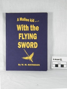
book, W.M. Matheson, A Mallee kid with the Flying Sword, 2004 (exact)
W.M. Matheson 409169 F/LT who lives at Wycheproof, relates his wartime experiences as a Flying Officer - William "Murdoch" Matheson made 194 operational flights and his accounts of missions and descriptions of different locations are interesting.An autobiographical account of service with the Royal Auxiliary Air Force in World War II. A hard covered blue book with gold inscription. Contents describe the author's overseas service in World War II. Two final chapters are the End of the War and Reflections. The Wycheproof Historical Society/With Best Wishes/Murdoch/409169 F/LT MATHESON WILLIAM MURDOCHno 601 county of london squadron, royal auxiliary air force, 1939 war, murdoch matheson, pilots foggia italy photo, italian war map, end of, the war 1945 -
 Wycheproof & District Historical Society Inc.
Bunguluke Map, Bunguluke District In 1923, 27.2.1923
By 1881 Bunguluke was a small settlement as recorded, December 5, in the Charlton "Mercury". It reports that in that year Draper's Store, Hotel and Post Office and residence at Bunguluke North was totally destroyed by fire. For years now there has been little sign of community life with houses few and far between and acreages have gone into larger holdings. The map references land blocks and owners for that era.This important map shows the local land ownership and local features that existed in 1923. This is a photocopied black and white map of Bunguluke in the County of Kara Kara, Number L5149. Marked - Photo Lithographed by W.J. Butson 27.2.1923. The details include numbers of allotments, property owners, roads, rivers. The boundaries marked are the Parish of Jeruk, Parish of Wycheproof, Parish of Cooroopajerrup. Wycheproof township location is shown with the Scale of Chains. Bunguluke maps for other years are also in the collection.map, bunguluke, jeruk, wycheproof, cooroopajerrup -
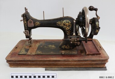 Flagstaff Hill Maritime Museum and Village
Domestic object - Sewing Machine, 1890s to 1911
This machine was made in Baden, Germany, for the Ward Brothers of Melbourne, who imported machines from various manufacturers and had them branded with their Ward Brothers decals. This machine is most likely dated before 1911, when the Ward Brothers became two separate businesses, as one of the decals appears to have been deliberately removed. The case is made in an attractive design and the machine itself has decorations that are pleasant to the eye. Even the metal cover of the folding handle has a swirling design on it. The machine has the added bonus of a ruler along the front base. Many sewing machine manufacturers in Germany produced their machines specifically for export. A company could mass-produce its machines and give the same product several different brand names, according to their overseas buyers. There was a huge market for domestic machines as it enabled tailored clothing to be made in households at a fraction of the retail prices. Ward Brothers began in Australia in the late 1890s and early sewing machines sold by them had the three brothers on their decals. In 1911 the brothers divided into two separate firms, one operating on his own, the other two remaining together, and all still operating in Melbourne and at first still using the name Ward Brothers.This sewing machine is one of two hand-operated Ward Brothers machines in our collection that were made in Baden, Germany, and the only one that has had the three Ward Brothers on its decal, and that has front and rear slide plates. This machine represents the early domestic market for sewing machines, making it possible for the everyday homemaker to produce fashionable garments and linen ware that was affordable. The owner of this machine could work at more than one location as it was portable and did not require a large space to set up. The machine is associated with the well-known Ward Brothers of Melbourne, who sold imported sewing machines that were branded with their own name. Sewing machine, hand operated, in wooden case. The machine is painted black with gold decals, and front and rear slide plates. The wooden base of the machine has an inlaid ruler. The case has curved sides and shaped ends, decorative woodwork on corners, an inlaid diamond pattern on top, and a folding metal handle. Accessories are included. The decals include doves, inscriptions and swirls, and there is a map of Australia with two portraits of men. The machine was made in Baden, Germany, for Ward Brothers, Melbourne. Images: Map of Australia with States marked, and with portraits of two men. [A portrait-sized area on the left of the men has had the image removed.] Text in printed script: "Specially / Made in Baden" "WARD BROTHERS / MELBOURNE" " with a Logo is a map of Australia,flagstaff hill, warrnambool, great ocean road, sewing machine, hand operated, pre-1911, domestic sewing, homemade clothing, fashion, ward brothers, made in germany, baden, front and rear slide plates, crank handle, hand crank sewing machine -
 Flagstaff Hill Maritime Museum and Village
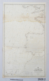
Document - Navigation Chart, Portsmouth to Canary Islands, CA. 1928
... map navigate navigation location vessel 1928 British Admiralty ...Navigation charts are drawn by professional hydrographers and describe the geography of land and water, enabling a water based navigator on board vessels such as ships to safely negotiate between ports locally and around the world. They are drawn to a particular standard with common symbols noting landmarks. The charts are used in conjunction with other navigational instruments and tools to calculate the vessel’s exact location and a safe route to its destination.The set of charts and their chart are of significance as examples of equipment and documents used to navigate the oceans of the world, particularly to Australia. Migration to Australia is an important part of this country's history.British Admiralty Navigation Chart - Portsmouth to Canary Islands - printed on rectangular white paper. Published in London by the British Admiralty in 1928.warrnambool, shipwreck coast, flagstaff hill, flagstaff hill maritime museum, flagstaff hill maritime village, chart, map, navigate, navigation, location, vessel, 1928, british admiralty, hydrographer, geography, admiralty chart, portsmouth, canary islands -
 Flagstaff Hill Maritime Museum and Village
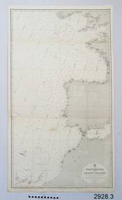
Document - Navigation Chart, Portsmouth to Canary Islands, Ca. 1928
... and tools to calculate the vessel’s exact location and a safe route ...This is an Official British Admiralty Navigation Chart, one of a set of 65 charts donated together with a wooden chart case. It was published and printed in London in 1928 by the British Admiralty. Navigation charts are drawn by professional hydrographers and describe the geography of land and water, enabling a water based navigator on board vessels such as ships to safely negotiate between ports locally and around the world. They are drawn to a particular standard with common symbols noting landmarks. The charts are used in conjunction with other navigational instruments and tools to calculate the vessel’s exact location and a safe route to its destination.The set of charts and their chart are of significance as examples of equipment and documents used to navigate the oceans of the world, particularly to Australia. Migration to Australia is an important part of this country's history.British Admiralty Navigation Chart - Portsmouth to Canary Islands - printed on rectangular white paper. Published in London by the British Admiralty in 1928.warrnambool, shipwreck coast, flagstaff hill, flagstaff hill maritime museum, flagstaff hill maritime village, chart, map, navigate, navigation, location, vessel, 1928, british admiralty, hydrographer, geography, admiralty chart, portsmouth, canary islands -
 Flagstaff Hill Maritime Museum and Village
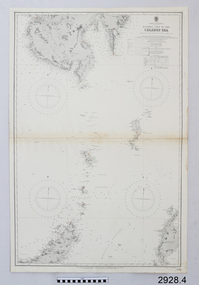
Document - Navigation Chart, Eastern Part of the Celebes Sea, Ca. 1928
... and tools to calculate the vessel’s exact location and a safe route ...This is an Official British Admiralty Navigation Chart, one of a set of 65 charts donated together with a wooden chart case. It was published and printed in London in 1928 by the British Admiralty. Navigation charts are drawn by professional hydrographers and describe the geography of land and water, enabling a water based navigator on board vessels such as ships to safely negotiate between ports locally and around the world. They are drawn to a particular standard with common symbols noting landmarks. The charts are used in conjunction with other navigational instruments and tools to calculate the vessel’s exact location and a safe route to its destination.The set of charts and their chart are of significance as examples of equipment and documents used to navigate the oceans of the world, particularly to Australia. Migration to Australia is an important part of this country's history.British Admiralty Navigation Chart - Eastern Part of the Celebes Sea - printed on rectangular white paper. Published in London by the British Admiralty in 1928.warrnambool, shipwreck coast, flagstaff hill, flagstaff hill maritime museum, flagstaff hill maritime village, chart, map, navigate, navigation, location, vessel, 1928, british admiralty, hydrographer, geography, admiralty chart, celebes sea -
Lorne Historical Society
Print - Framed coloured print, Print Accommodation Lorne to 1950
... - My Cree, Glendora, Ozone House and a small map showing... map showing the locations of the accommodation. We believe ...Rob Coy depicted the 22 following buildings with a map 1. Bonnie Doon 2. Gracedale 3. Cora Lynn 4. Carinya 5. Kia-Ora 6. Kalimna 7. Argyll 8. Minapre 9. Erskine House 10.Hotel Pacific 11. The Cumberland 12. Riverview 13. Hotel Lorne 14. The Chalet 15. Santoy 16. Clovelly 17. Yendallock 18. Nenthorne 19. Quamby 20. Ben-My-Kree 21. Glenora 22. Ozone House Rectangular framed color print of Rob Coy ‘ sketch Accommodation Lorne to 1950. The guest houses were, Bonnie Doon, Gracedale, Cora Lyn, Karinya, Kia Ora, Kalimna, Argyle, Minapre, Erskine House, Hotel Pacific, Cumberland, Riverview, Lorne Hotel, Chalet, Santoy, Clovelly, Yendaloch, Nenthorne, Quamby, Ben - My Cree, Glendora, Ozone House and a small map showing the locations of the accommodation. We believe this this is the original print. The colors are mainly blue and light tan. rob coy, lorne, accommodation, hotels, guest houses, pubs, erskine house -
 Mission to Seafarers Victoria
Photograph - Photographs, Serie, Mission to Seafarers Victoria, The sea is all around us, 29 May 2015
EXHIBITION in the DOME The Sea is All Around Us - Margaret Woodward 11-21 May 2015 Dome Gallery – Mission to Seafarers, 717 Flinders Street, Melbourne, Australia. 37 º 49'21" S 144º 57'03"E Hours: Daily 11.00am - 4.00pm The sea is all around us is a multi-layered event which will create a memorable experience for those visiting the Dome Gallery and the Mission to Seafarers in Melbourne’s Docklands. The event will acknowledge and raise awareness of the working lives and journeys of seafarers by making visible their role in transporting commodities, materials and objects to and from Australia’s shores. This installation invites seafarers and visitors to participate in a global project which aims to witness sea journeys and trace the mobile life of seafarers and souvenirs. For a fortnight in May 2015, the Dome Gallery will become an architectural large scale compass, with the circular floor marking the intersection of its latitude and longitude (37 º 49'21" S 144º 57'03"E). Over these two weeks the Dome Gallery will be inscribed with marks recording journeys made by seafarers, recording destination and departure ports, home lands and waterways, and in doing so making visible a small segment of the global patterns of seafaring. Custom-made souvenirs designed for the installation will be given to seafarers as gestures of welcome and a memento of their visit. The souvenirs originating in Poland will continue their journey by sea, to destinations beyond the Dome becoming part of the global network of seafaring, with an invitation for seafarers to record their future journeys using QR code scanning technologies. It is hoped that by releasing the 200 limited edition souvenirs accompanying the seafarers the mobile life of souvenirs and seafarers will also become visible. For more information visit the website: sensingtheremote.net Margaret Woodward is Associate Professor of Design at Charles Sturt University For a fortnight in May 2015, Margaret Woodward was ‘in residence’ at the Mission to Seafarers Norla Dome Gallery with her participatory installation project "The Sea is All Around Us". The floor of the gallery became a large scale compass. Seafarers were welcomed to the gallery their ships, journeys and destinations were recorded and mapped on the floor drawing. Seafarers were welcomed with cake and souvenir mugs of tea. These mugs, a momento for the seafarers, were inscribed with a scannable QR code and an invitation for seafarers to record their journeys on a dedicated project website. Around 120 souvenirs are now continuing their journey by sea and seafarers have scanned the mugs from locations including Singapore, Brisbane, Fremantle, Adelaide, Busan and Johor! After the exhibition Margaret Woodward was able to follow the seafarers' whereabout: ""The Sea is all Around Us". I am in awe of where this project might go, well done Margaret. One week has passed since finishing up at the Mission to Seafarers Victoria. Today I check my website and can see that the cup-carrying seafarers are reaching warmer climates, they tell me it’s getting hot as some are already in Suva and Port Lautoka. I’ve watched the souvenirs travel and fan out from Melbourne, some West to Adelaide and Fremantle, others going north to Sydney Brisbane, Singapore and Busan. Another seafarer scans in from Changi Airport, excited to be going home for some time with his family in the Phillipines. I keep an eye on my ‘fleet’ of 22 ships that visited the Dome Gallery, and see where they are on the Live Shipping website, watch some of them sail up the coast of Western Australia and marvel at the steady pace this journey takes. I am so used to flying over coastlines and countries in a matter of hours, impatiently watching the tracking screen from my airline seat, this shipping pace seems so much more real, so much more of a passage. I feel connected to these ships, to the people on board, to know that an object has passed from my hands to theirs, now holding in it my cargo of concern."margaret woodward, installation, exhibition, norla dome, 2015, sea voyage, sea journey, cultural events -
 Greensborough Historical Society
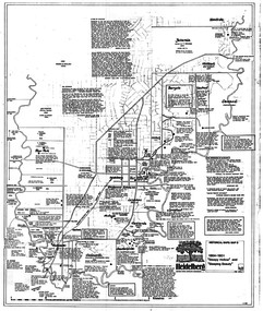
Map, Heidelberg. Historic River Landscape Assessment. Historical maps: Map C 1851-1863. "The Garden of the colony", 1985c
Geographical area of around 35 sq. kilometres marked with physical features such as major roads, vegetation and properties, with locations and notes of the increasing number of farms, gardens orchards and vineyards which had become established in addition to pastoral runs. Bounded by Shire of Diamond Valley to the North, Darebin Creek to the West and Plenty River to the East.Black and white sketch map on white paperheidelberg, heidelberg - maps -
 Greensborough Historical Society
Map, Heidelberg: Historic River Landscape Assessment. Historical maps. Map D 1864 -1901 "Sleepy Hollow" and "Sleeping beauty", 1985c
Geographical area of c. 35 sq. kilometres marked with physical features such as major roads, rivers, vegetation and properties, with locations and notes on the increasing number of farms, orchards and vineyards that had been developed in addition to pastoral runs. Bounded by Shire of Diamond Valley to the North, Darebin Creek to the West, and Plenty River to the East.Black and white sketch on white paper. Second copy 600 x 430 cm printed in black on semi-opaque paperheidelberg, heidelberg - maps -
 Greensborough Historical Society
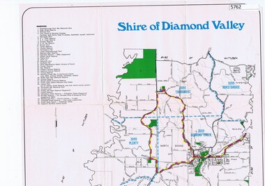
Map, Map - Shire of Diamond Valley, 1990c
Map issued by the Shire of Diamond Valley showing location of key organisations and features Map printed in colour, one sideshire of diamond valley -
 Greensborough Historical Society
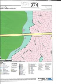
Map, Pioneer children's graves precinct, 1848-1860
... Map showing the location and surrounds of Pioneer... Plenty Lower Plenty melbourne Map showing the location ...Map showing the location and surrounds of Pioneer Children's Cemetery on the Plenty River in Greensborough. Children from pioneer families are buried here.Official government planning map for the Pioneer Children's Graves Precinct.Printed coloured copy of map of Plenty River areapioneer childrens cemetery, greensborough, partington, whatmough -
 Greensborough Historical Society
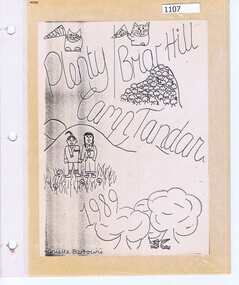
Photograph Album, Plenty/Briar Hill Camp 1989, 04/09/1989
Photographs and maps from Plenty/Briar Hill Camp 1989. Possibly a school project, includes itinerary. Photographs are not named. Location: "Tandara" Halls Gap.Colour photographs and maps in albumHand drawn front cover with name of artist.plenty, briar hill -
 Greensborough Historical Society
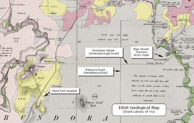
Map - Geological Map, 1868 Geological map of Greensborough (annotated), 1868_
... Annotations on map show locations.... locations. Digital copy of colour map. 1868 Geological map ...This geological map from the State Library of Victoria collection has been annotated by GHS member Ian Bryant to show some local landmarksDigital copy of colour map.Annotations on map show locations.greensborough - maps, 1860s melbourne, suburbs, geography, roads -
 Greensborough Historical Society
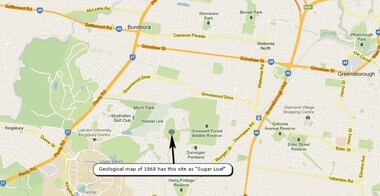
Map, Overlay/comparison Map for 1868 Greensborough-Bundoora Geological Map area, 1868_
This map is a comparison to the map at Item 2518, questioning the location of "Sugar Loaf". Annotation by GHS member Ian Bryant.Map copied from Google maps.Annotation on map.sugarloaf hill, bundoora, greensborough - maps -
Glenelg Shire Council Cultural Collection
Programme - Programme - Upwelling Festival, 2012, c. 2012
... and green motifs and print, folds out, information one side, map... and green motifs and print, folds out, information one side, map ...Programme for Upwelling Festival 3rd November 2012, at Portland. Presented by Rotary Club of Portland Bay Inc. White, blue and green motifs and print, folds out, information one side, map with programme and location of events/displays on the other.marine ecology, upwelling festival, whales -
Glenelg Shire Council Cultural Collection
Booklet - Booklet - Historic Portland Street Names Victoria, c. 1972
Sixteen page booklet, grey card cover, red and blue print, Historic Portland street Names, their location, origin and significance. Yellow pages, black print, street map affixed to inside back cover -
Glenelg Shire Council Cultural Collection
Book, E.N.T. HENRY, Historic Portland Street Names, 1972
Book of historic Portland street names, including their origin, location and significance. A street map of Portland is attached to inside of back cover. Semi gloss card covers, grey with red and blue print. Inside pages pale yellow, black print. Map of Portland white with black print.local history, street names, portland, directory