Showing 373 items matching "princes highway"
-
 Ballarat Heritage Services
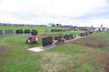
Photograph - Photograph - Colour, Clare Gervasoni, Tower Hill Cemetery, 2009, 26/07/2009
... side of the Princes Highway The, between Port Fairy... on the north side of the Princes Highway The, between Port Fairy ...The Tower Hill Cemetery is located near Koroit on the north side of the Princes Highway The, between Port Fairy and Warrnambool. The first burial at Tower Hill Cemetery took place in 1856. Over 150 years there has been over 8,000 burials. Around 45 percent of the burials are in unmarked graves.Colour photograph of a headstone in the Tower Hill Cemetery.tower hill cemetery, william rutledge, eliza rutledge -
 Ballarat Heritage Services
Photograph - Photograph - Colour, Clare Gervasoni, Tower Hill Cemetery, 2009, 26/07/2009
... side of the Princes Highway The, between Port Fairy... on the north side of the Princes Highway The, between Port Fairy ...The Tower Hill Cemetery is located near Koroit on the north side of the Princes Highway The, between Port Fairy and Warrnambool. The first burial at Tower Hill Cemetery took place in 1856. Over 150 years there has been over 8,000 burials. Around 45 percent of the burials are in unmarked graves.Colour photograph of a headstone in the Tower Hill Cemetery.tower hill cemetery -
 Ballarat Heritage Services
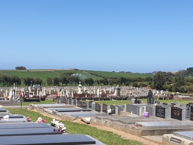
Photograph - Photograph - Colour, Clare Gervasoni, Tower Hill Cemetery, 2019, 03/01/2019
... on the north side of the Princes Highway The, between Port Fairy... on the north side of the Princes Highway The, between Port Fairy ...The Tower Hill Cemetery is located near Koroit on the north side of the Princes Highway The, between Port Fairy and Warrnambool. The first burial at Tower Hill Cemetery took place in 1856. Over 150 years there has been over 8,000 burials. Around 45 percent of the burials are in unmarked graves. Colour photograph of the Tower Hill Cemetery. with potatoes being irrigated in te background. The cemetery is laid out on design of a Celtic Cross.tower hill cemetery, tower hill, cemetery -
 Ballarat Heritage Services
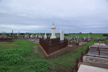
Photograph - Photograph - Colour, Clare Gervasoni, Headstone of Patrick Carroll in Tower Hill Cemetery, 2019, 03/01/2019
... side of the Princes Highway The, between Port Fairy... on the north side of the Princes Highway The, between Port Fairy ...The Tower Hill Cemetery is located near Koroit on the north side of the Princes Highway The, between Port Fairy and Warrnambool. The first burial at Tower Hill Cemetery took place in 1856. Over 150 years there has been over 8,000 burials. Around 45 percent of the burials are in unmarked graves.Colour photograph of the headstone of Patrick Carroll in the Tower Hill Cemetery. . by Patrick Carroll InLoving Remembrance of my beloved son Patrick Who departed this life the 20th day of April 1874 Aged 2 years and 2 months Also his beloved mother Who departed this life 15th Sept 1876 Aged 74 years Also his who died 16th November 1890 Aged 89 Years Also Patrick Carroll Who died 10 July 1906 aged 72 years Rest in Peace tower hill cemetery, patrick carroll -
 Warrnambool and District Historical Society Inc.
Archive (collection) - Elmac Hydroponics business material, Elmac Hydroponics, 2004
... ', Princes Highway, Allansford, Victoria from 1996 to 2004...', Princes Highway, Allansford, Victoria from 1996 to 2004 ...Business owners collectionCollected for archival reasonsMaterial in foldernewspaper cuttings, certificates, photographs, articles re the business operationswestern district industries, warrnambool, elmac hydroponicswestern district industries, warrnambool, elmac hydroponics -
 Orbost & District Historical Society
black and white photograph, late 19th century - early 20th century
... on the Princes Highway, 27 km east of Orbost in East Gippsland. The first... on the Princes Highway, 27 km east of Orbost in East Gippsland. The first ...This is a photograph of Alice Swallow's hotel at Cabbage Tree. The settlement of Cabbage Tree Creek is located on the Princes Highway, 27 km east of Orbost in East Gippsland. The first white settler arrived in the valley in 1887 cutting a dray track from Marlo to the south-west. Several families cleared the alluvial flats, growing maize, peas and beans and raising pigs, cattle and sheep. Later the farmers milked cows, sending cream to Orbost. In the late 1890s, small quantities of alluvial gold were found in the creek. A school commenced classes in 1913, but enrolment was small and at times the school operated part time with several other small schools in the area. The school building served as a hall for the district. From the 1920s the Cabbage Tree Hotel catered to drivers on the improved Princes Highway. (info. from Victorian Places)This is a pictorial record of Cabbage Tree, East Gippsland in the late 20th century. It shows a building that no longer exists.A black / white photograph of a small, single - storey wooden building in a bush setting. There are people standing in front of the building with a horse and wagon nearby. In the foreground is a wagon with four horses hitched to it and the driver seated behind the horses. -
 Lakes Entrance Historical Society
Photograph - Bullock Island, Fraser Ian, 1920c
... Prince's Highway from North Arm bridge, east end of Bullock Island... photograph of Bullock Island, showing Prince's Highway from North Arm ...Black and white photograph of Bullock Island, showing Prince's Highway from North Arm bridge, east end of Bullock Island and bridge, entrance to Bass Strait and sand dunes along Cunninghame Arm. Western end of Bullock Island bridge raised to allow small boats access to North Arm and Cunninghame Arm, became known as Humpy Bridge. Lakes Entrance Victoria islands, waterways, topography, bridges -
 Warrnambool and District Historical Society Inc.
Booklet Lettering Book, Deakin University Planning Unit, The Warrnambool Profile – An Analysis of Deakin University’s Warrnambool Campus, 1999
... , a 94 hectare site on the Princes Highway, five kilometres from..., a 94 hectare site on the Princes Highway, five kilometres from ...This booklet was prepared in 1999 by the Planning Unit of Deakin University. It gives current data on the campus and projections and suggestions for the future. The Warrnambool Campus of Deakin University was established in 1990 after a merger with the Warrnambool Institute of Advanced Education which was already on the site that the university still occupies. This is Sherwood Park, a 94 hectare site on the Princes Highway, five kilometres from Warrnambool.This booklet is of some interest as it contains information on the Warrnambool Campus of Deakin University ten years after it was first established. This is a soft cover booklet of 179 pages. It has an orange front cover and a black back cover with black printing and a plastic over-sheet. The booklet has printed information, tables and graphs. It has black plastic spiral binding. deakin university, warrnambool campus -
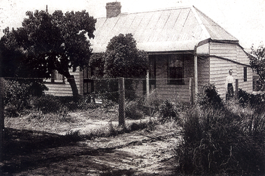
 Lakes Entrance Historical Society
Photograph - Historic House, 1980
... by Val Northrope and moved to their property at Princes Highway... by Val Northrope and moved to their property at Princes Highway ...It is believed this house was situated at the New Works, the front room being used for church services. It was moved to Church St Lakes Entrance and in the early 1990's was bought by Val Northrope and moved to their property at Princes Highway. It was moved again to the Northropes property on Wards Rd Tambo upper in the early 2000's. See VTMH 05007 for more recent photo'sColour photograph of a small cottage situated in Church Street, has corrugated iron roof painted red, veranda across front over front door, window each side of door glazed with small panes. Lakes Entrance Victoriahouses, urban renewal, heritage study -
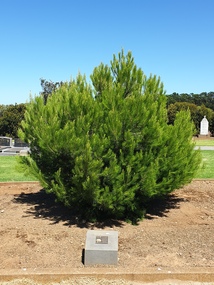 Ballarat Heritage Services
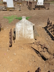
Photograph - Photograph - Colour, Clare Gervasoni, Aleppo Pine, Tower Hill Cemetery, 2019, 03/01/2019
... side of the Princes Highway The, between Port Fairy... on the north side of the Princes Highway The, between Port Fairy ...The Tower Hill Cemetery is located near Koroit on the north side of the Princes Highway The, between Port Fairy and Warrnambool. The first burial at Tower Hill Cemetery took place in 1856. Over 150 years there has been over 8,000 burials. Around 45 percent of the burials are in unmarked graves. In 2023 this tree was no longer in existence, and a smaller tree was struggling in this site.Colour photographs of an Aleppo Pine planted in the Tower Hill Cemetery to mark the centenary of the landing at Galipolli.aleppo pine, anzac centenary, centenary, anniversary, tower hill cemetery, gallipoli -
 Lakes Entrance Historical Society
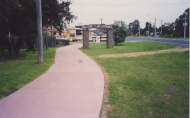
Photograph - Eastern entrance to Lakes Entrance, Lakes Entrance Tidy Town Committee, 1990
... Colour photograph showing Eastern entrance to town Princes... Eastern entrance to town Princes Highway on right of image pathway ...Colour photograph showing Eastern entrance to town Princes Highway on right of image pathway to left of Welcome to Lakes Entrance sign holding metal sign indicating local services Lakes Entrance Victoria. Also two other colour photographs taken at Eastern entrance to Lakes Entrance from pathway beside St. Brendans looking towards Eastern Beah Road Tidy Town signs in foreground topography, signage, tidy town -
 Lakes Entrance Historical Society
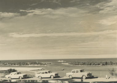
Photograph - Views from Jemmys Point, Lakes Entrance c1960, 1960 c
... a bend in the Princes Highway showing three cars parked... in the Princes Highway showing three cars parked at the viewing area ...Black and white photograph of the entrance taken from a bend in the Princes Highway showing three cars parked at the viewing area beside the highway. Boat and dredge in waterway below highway dredged sand in Bullock Island extension, dredge Mathew Flinders working outside the entrance Lakes Entrance Victoria. Also two black and white photographs taken of Entrance from Jemmys Point taken 1960 c waterways, vehicles, islands, roads and streets -
 Orbost & District Historical Society
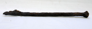
bridge spike
... by the Road Construction Authority in 1989 where the Princes Highway... Construction Authority in 1989 where the Princes Highway passes over ...This spike came from the old Brodribb River bridge which is about 9.6 kilometres from Orbost. The Brodribb River joins the Snowy River north of Marlo. In 1906, a bridge replaced the punt over the Brodribb River, improving communication with Orbost. It was eventually replaced by a reinforced concrete bridge built by the Road Construction Authority in 1989 where the Princes Highway passes over the Brodribb RiverThis item belongs to a significant local structure which has been replaced.A very rusty iron bridge spike from the old Brodribb Bridge.brodribb-river bridge-spike -
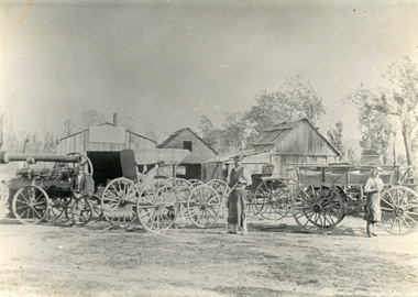 Lakes Entrance Historical Society
Photograph - Harry Froud's coach factory, P Hancock, 1900 c
... of Princes Highway and Bruthen Road, (now site of Black Stump Store... of Princes Highway and Bruthen Road, (now site of Black Stump Store ...Henry Froud's Blacksmith Coach Building and Wheelwright's business set up at original surveyed site west of present township, nearer to cemetery turnoff,. Business first moved to corner of Princes Highway and Bruthen Road, (now site of Black Stump Store), then moved to premises built by Harry Froud on south side of highway, corner of Punt Road, (present site of BP Garage).Black and white photograph of Harry Frouds first coach factory west of present township, showing three men in front of four wheeled vehicles including a steam engine. Three workshops in background, two having bark roofs, man in centre identified as Harry Froud, William Henry. Johnsonville Victoria. transport, factory, people, local history -
 Whitehorse Historical Society Inc.
Photograph - B/W Photograph, Lowen family Home, 1/06/1920 12:00:00 AM
... Hewlett Road and from High Street Road to Princes Highway Was May... Hewlett Road and from High Street Road to Princes Highway Was May ...The home of Frederick & Julia Lowen was re-located in 1933 to allow Blackburn Road (which then ended in the vicinity of what is now Hawthorn Road) to be extended through to Burwood Road (now Burwood Highway). That section of Blackburn Road that now runs between Burwood Highway and High Street Road was originally Hewlett Road and from High Street Road to Princes Highway Was May Road.Black & white photo of the Lowen home at East Burwood in the mid 1920s. The lady on the right is presumed to be Julia Lowenlowen family home, east burwood -
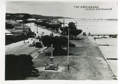 Lakes Entrance Historical Society
Postcard - Esplanade Lakes Entrance, 1945c
... on north side of road, Princes Highway, which follows the margin... of road, Princes Highway, which follows the margin of the lake ...Original from wallet of miniature postcards produced by Bulmer, two copies. 01419.1 and .2 Also two enlargements 17 x 25 cmBlack and white small format postcard of Esplanade, taken from the WW2 Air Observers Spotting Tower. In the foreground is the Cenotaph erected 1922 on the grass verge between road and lake. Trimmed WW1 Cypress trees also on verge. Cars and truck on highway all travelling in easterly direction. Houses and businesses on north side of road, Princes Highway, which follows the margin of the lake shore. Lakes Entrance VictoriaThe Esplanade Lakes Entrancetownship, waterfront, transport, world war 1939 - 1945, world war 1914-1918 -
 Lakes Entrance Historical Society
Postcard - Backwater, Bulmer H D, 1922c
... and various boats on lake. Princes Highway went along Esplanade, Myer... foreground, Eastern wharf and various boats on lake. Princes Highway ...Black and white photographic postcard, showing early aerial view of township of Lakes Entrance, Cunninghame Arm, North Arm and sand dunes, ocean in lower foreground, Eastern wharf and various boats on lake. Princes Highway went along Esplanade, Myer Street and Roadknight Street, very little vegetation on sand dunes, no foot bridge yet, good view of North Arm, few houses. Lakes Entrance VictoriaLakes Entrance and Backwater from the Air.islands, aerial photograph, waterways, topography, township -
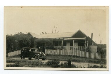 Orbost & District Historical Society
black and white photograph, 1920s -1930s
... of Cabbage Tree Creek is located on the Princes Highway, 27 km east... of Cabbage Tree Creek is located on the Princes Highway, 27 km east ...The Cabbage Tree Creek township was originally established to support the booming timber industry of the mid 20th century. Five timber mills worked full time supporting the families that were drawn to the area's wealth of natural resources. The settlement of Cabbage Tree Creek is located on the Princes Highway, 27 km east of Orbost in East Gippsland. The first white settler arrived in the valley in 1887 cutting a dray track from Marlo to the south-west. Several families cleared the alluvial flats, growing maize, peas and beans and raising pigs, cattle and sheep. Later the farmers milked cows, sending cream to Orbost. In the late 1890s, small quantities of alluvial gold were found in the creek. A school commenced classes in 1913, but enrolment was small and at times the school operated part time with several other small schools in the area. The school building served as a hall for the district. From the 1920s the Cabbage Tree Hotel catered to drivers on the improved Princes Highway. (info. from Victorian Places)This is a pictorial record of Cabbage Tree, East Gippsland in the late 20th century. It shows a building that no longer exists.A small black / white photograph of a single storey timber building. On a sign below the roof is "Cabbage Tree Hotel". The hotel is surrounded by a wooden picket fence. A man and woman are standing on either side of a motor car parked on the roadway in front of the building.on back - on label - Cabbage Tree Hotelcabbage-tree-hotel -
 Orbost & District Historical Society
black and white photograph, late 19th century
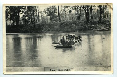
... major flood protection works have been implemented. The Princes... major flood protection works have been implemented. The Princes ...A punt crossed the Snowy River at Orbost from 1884. A bridge was constructed in 1893, but was soon damaged by a huge flood. Flooding was a regular occurrence, the worst inundations being in 1870, 1893, 1925, 1934, 1952 and 1971. Over the years major flood protection works have been implemented. The Princes Highway, which passes Orbost, now crosses the flood plain on raised concrete supports. (info, from Victorian Places Orbost)This item is associated with the Snowy River and its history. It is a pictorial record of transport in the late 19th century.A black / white photograph (copy) of a punt loaded with people and a horse-drawn carriage making its way across a river.on front at bottom - "Snowy River Punt"snowy-river-orbost transport shipping -
 Orbost & District Historical Society
book, Broadbent's Melbourne - Sydney Guide Book, 1936
... , the Prince's Highway route marked. This is inset in a drawing of a car... Sydney to Melbourne, the Prince's Highway route marked ...Broadbent's Official Road Guides Company took over George R. Broadbent's business in 1935. In 1963, it changed its name to Broadbent's Road Maps Pty. Ltd. George Robert Broadbent (1863-1947), cyclist and map publisher, was born on 3 November 1863 at Ashby near Geelong, Victoria. At various times Broadbent held most Victorian and Australian road cycling records. Broadbent became an active vice-president of the Good Roads Association of Victoria in November 1912 and was consulted regularly during the preparation of the country roads bill. That year he took over the Argus motoring column, wrote tirelessly on road improvements and maintenance, and became manager of the Automobile Club's new touring department in 1914.A 160 pp road guide book titled Broadbent's Official Road Guide Melbourne - Sydney. The front cover has a yellow background with a map of the coastline from Sydney to Melbourne, the Prince's Highway route marked. This is inset in a drawing of a car driving along the coastal road.The book contains speedometer readings, route maps, advertisements and photos of points of interest. In the top right is the logo of the Royal Automobile Club of Victoria and at the bottom right is the price 1/-.traavel road-guides broadbent-george car-touring -
 Warrnambool and District Historical Society Inc.
Mixed media - Travellers Aid Bag, Travellers Aid bag & Contents, C 1980
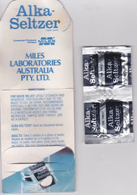
... Plastic Bag: Mid City Motels, Princes Highway, Warrnambool..., Princes Highway, Warrnambool, 055 62 8026, Doveton Street ...These items were given to clients of the Mid City Motel (probably the one in Ballarat ). The Mid City Motel company was formed in 1963 by a syndicate with the motel in Raglan Parade, Warrnambool. It was later sold with the company liquidated in 1982. The expansion from Warrnambool to Ballarat occurred in 1970 with a building in Doveton Street North, Ballarat. Items such as the sewing kit and shower cap are still given out as promotional material in many motels today. These items are of little importance but are examples of the promotional activities of the motel/tourism scene 30 or so years ago. They may be useful for display.This is a small plastic bag containing a paper sewing kit and a paper folder containing two Alka-Seltser tablets. The sewing kit is red and white and the Alka Seltzer packet is mostly blue. The three items come from the Mid-City Motel and are intended to be kept in a car. Plastic Bag: Mid City Motels, Princes Highway, Warrnambool, 055 62 8026, Doveton Street, Ballarat, 053 31 1222, Travellers Aid Bag for your car with Sewing Kit, Alka Seltzer, Shoe Shine, Shower Cap, Have a Nice Day, Ballarat City Map.warrnambool, mid city motel, tourism -
 Orbost & District Historical Society
badge, 1890's
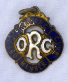
... a block of land situated on the Princes Highway, for the Brodribb... a block of land situated on the Princes Highway, for the Brodribb ...This is a member's badge for the Orbost Racing Club and belonged to Mat Lynch. Secretary was Mr W. A. Malcolm. Some of the earliest horse races were held on a course in a paddock belonging to Mr James Cowell at Jarrahmond. For a long time horse races were part of the Marlo Picnic Races. Bellagoogan on Majors Creek near Orbost was the site of the first race course. Mat Lynch was a prominent local identity and generously donated a block of land situated on the Princes Highway, for the Brodribb Hall.Horse racing played a vital role in the history of Orbost. This item is connected to that role.A small metal badge which is a diamond shape with rounded corners. It has a small metal loop at the top. In gold print is "Member Orbost Racing Club" on a dark blue enamel around the edge. In the centre is "ORC" in white enamel.On back - 28 - LYNCH - almost indecipherable.orbost-racing-club lynch-mat recreation horse-racing -
 Warrnambool and District Historical Society Inc.
Label, Rosebrook Cheese and Butter Factory, Early 20th century
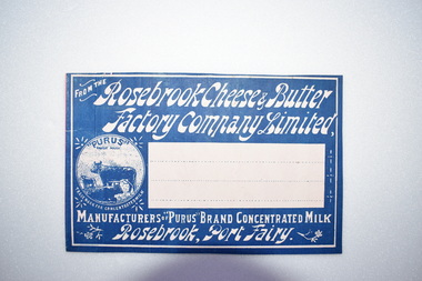
... Warrnambool on the Princes Highway. ... about 20 kilometres from Warrnambool on the Princes Highway ...The Rosebrook Cheese and Butter Factory was opened in November 1888 by Messrs Lydiard &T F Rutledge & was a cooperative factory managed by Mr. Goldie. It operated out of the former Rosebrook Flour Mill which was built on the banks of the Moyne River near the Rosebrook bridge in the late 1840s. In 1896 the factory commenced the production of the condensation of milk. The company closed in 1911. The building and machinery were sold in 1917. Rosebrook is situated about 20 kilometres from Warrnambool on the Princes Highway. This label is of some local significance as the Rosebrook Cheese and Butter factory operated for 30 years Rectangular dark blue and white label featuring text and a trade mark. The latter is circular with three cows pictured. There are decorations of flowers and leaves. The central area of the label is white with three lines. The label is adhered to a piece of pink card.FROM THE Rosebrook Cheese & Butter Factory Company Limited, MANUFACTURERS OF "PURUS BRAND CONCENTRATED MILK Rosebrook, Port Fairy. "PURUS" TRADE MARK FOR CONCENTRATED MILKrosebrook, cheese and butter, concentrated milk, lydiard, rosebrook butter factory -
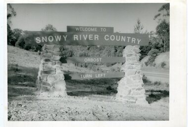 Orbost & District Historical Society
black and white photographs, second half 20th century
... sign - Princes Highway - Newmerella" 3277.2 on back - "East... on back - "WELCOME TO SNOWY RIVER COUNTRY - ORBOST sign - Princes ...These photographs are pictorial records of the signs at the Orbost town entry points.Three black / white photographs. 3277.1 is a sign on stone pillars at the top of a hill - "WELCOME TO SNOWY RIVER COUNTRY ORBOST TURN LEFT". 3277.2 shows a road leading into a town. There is a sign on the left - "ORBOST" and a service station on the right. 3277.3 shows a row of newly planted trees between a road and a school.3277.1 on back - "WELCOME TO SNOWY RIVER COUNTRY - ORBOST sign - Princes Highway - Newmerella" 3277.2 on back - "East Gippsland Shire Sign on eastern approach to ORBOST., in Salisbury Street, near Orbost Secondary College" 3277.3 on back - "Tree planting in Salisbury St, Orbost in front of Orbost High School looking west towards Orbost township"photographs-orbost orbost-township-entry salisbury-street-trees town-entry road-signs-orbost -
 Orbost & District Historical Society
book, Vic Roads Centenary 1913 -2013, 2013
... for the Snowy River Bridge (Princes Highway) at Orbost 1974-1976.... for the Snowy River Bridge (Princes Highway) at Orbost 1974-1976 ...The publication, VicRoads Centenary: Keeping Victorians Connected for 100 Years, looks at the people and projects that define VicRoads’ history. Written by current and former VicRoads’ employees, the publication details the organisation’s portfolio of major projects, which includes the Great Ocean Road, Hume Highway and Eastern Freeway. Other sections report on Victoria’s world-first road safety initiatives, VicRoads’ use of technology and sustainability measures. (ref VicRoads) This item is one of several books donated by David Jellie at a presentation to Orbost Historical Society. He was a contributor to the book and was the engineer for the Snowy River Bridge (Princes Highway) at Orbost 1974-1976.This book is a useful reference tool on the history of road construction in Victoria including East Gippsland.A thick, bound paperback book, titled "VicRoads Centenary Keeping Victorians Connected for 100 Years". On the front cover is a black/white photograph of two men working on a road. One has a pick. The book contains the history of VicRoads, photographs, maps and advertisements. Some are b/w. Others are coloured.vicroads book roads snowy-river-bridge jellie-david -
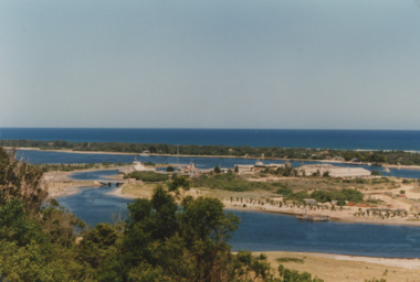 Lakes Entrance Historical Society
Photograph - Bullock Island Lakes Entrance, M Holding, 1988 c
... dumped sand on Bullock Island taken from Princes Highway lower... dumped sand on Bullock Island taken from Princes Highway lower ...Kalimna Heights showing development on Bullock Island including Pecks Factory. The Club Spit of dredged sand is acquiring vegetation. April Hamer dredge moored at Port Jetty, new bridge in place Lakes Entrance VictoriaAlso two colour photographs showing dumped sand on Bullock Island taken from Princes Highway lower parking bay June 2000. Donor L P Newspaper number 04209.1 size 10 x 15 cm and 04209.2 size 10 x 15 cm|Two colour photographs of Gippsland Ports Facilities taken from waterway numbers 04208.3 and 04208.4 size 10 x 15 cmColour photograph taken from Kalimna Heights showing development on Bullock Island including Pecks Factory. The Club Spit of dredged sand is acquiring vegetation. April Hamer dredge moored at Port Jetty, new bridge in place Lakes Entrance Victoriaislands, waterways, gippsland lakes -
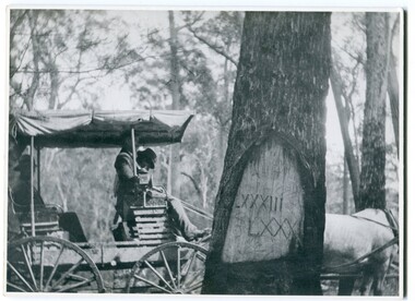 Orbost & District Historical Society
black and white photograph, 1913
... Wales border - now the Princes Highway.... Wales border - now the Princes Highway. This is a pictorial ...When marking a boundary for a registered plan, a surveyor would place “Reference Marks” with a stated bearing and distance to a boundary corner. These trees were typically marked by cutting the bark of the tree in a shield or blaze. Until July 1886, surveyors were only able to use trees as reference marks to boundary corners. After July 1886 surveyors were able to use “permanent marks” which were either a glass bottle, gas pipe or iron bolt (for homestead surveys only). This photograph shows the reference tree, 83 miles from Marlo via the original surveyed road v ia Sydenham Inlet and Tamboon, south of Mount Drummer to the New South Wales border - now the Princes Highway.This is a pictorial record of an old survet tree. Knowledge of their location, abundance and condition not only provide important insights to past survey practice, but also provide a lasting legacy of a regions land-use history. Old survey trees serve as one of the few remaining physical legacies of early European land settlement history.A large black / white photograph of a horse and buggy pulled up alongside a reference tree which has notches and markings of Roman numerals.on back - " Refernce tree 83 miles from Marlo........to N.S.W. Border"survey-tree reference-tree -
 Warrnambool and District Historical Society Inc.
Map - An Angler's map of the Hopkins River Estuary, Angler's map Hopkins River, 1980s
... from Warrnambool on the Princes Highway. Today the site... at the Sherwood Campus five kilometres from Warrnambool on the Princes ...This is a map of the Hopkins River Estuary prepared by Dr John Sherwood for the benefit of anglers. The information on the sheet includes the location of sand banks, the water depths, boat ramp facilities and public access facilities. Some of the information has been gathered from aerial photographs. The map has been produced by the Warrnambool Institute of Advanced Education which was developed in the late 1960s from the tertiary section of the Warrnambool Technical College and with all its departments established by 1984 at the Sherwood Campus five kilometres from Warrnambool on the Princes Highway. Today the site is occupied by Deakin University, Warrnambool campus. The Warrnambool Anglers’ Club has its headquarters on the banks of the Hopkins River near the mouth of the river and the Lyndoch Aged Care facility.This map is of interest as a specialist one, providing fishermen with detailed information on all aspects of the Hopkins river estuary. Fishing has been both a profession and a popular recreational pursuit for Warrnambool residents since the early days of the city’s settlement. The Hopkins River Estuary has been a focal point for fishermen throughout Warrnambool’s history. This is a sheet of paper folded three times to produce a folded map. The front cover has a black and white photograph of two fishermen with a large fish. The map of the Hopkins River Estuary is in yellow, blue and black and covers the side of one sheet and three quarters of the other side. There is an advertisement for the Hopkins River Boathouse with a black and white sketch of the boathouse and notes on the map written by Dr John Sherwood. There are several diagrams showing the water depths. The map has some silverfish damage and some tearing at the folds. warrnambool anglers’ club, history of warrnambool, hopkins river, hopkins river estuary, john sherwood -
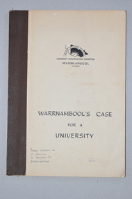 Warrnambool and District Historical Society Inc.
Booklet, Warrnambool's Case for a university, 1961
... to Sherwood Park, a 94 hectare site on the Princes Highway five... to Sherwood Park, a 94 hectare site on the Princes Highway five ...The information in this booklet was prepared by a University Investigation Committee formed in Warrnambool in 1961 to present the case for the establishment of a university in the Warrnambool area. The chairman of this committee was the Mayor of Warrnambool, Cr P. O’Sullivan and the secretary was W. L. George of Warrnambool. This submission was unsuccessful at the time but campaigning for a university continued. In 1961 Warrnambool Technical School in Timor Street was offering both secondary and tertiary courses in the technical and trades areas and in 1969 the tertiary section of this Technical School became the Warrnambool Institute of Advanced Education. The tertiary section was relocated in 1984 to Sherwood Park, a 94 hectare site on the Princes Highway five kilometres from Warrnambool’s C.B.D. In 1990 Deakin University established a regional campus at Sherwood Park after a merger with the Warrnambool Institute of Advanced Education. This booklet has some historical significance as it contains the information collated on the campaign in Warrnambool and the Western District for a university to be established in the Warrnambool area.This is a soft cover booklet of 48 pages. It has a beige-coloured cover with black printing. The booklet has been bound with brown tape. It has printed information, black and white photographs, a fold-out map, graphs and tables.deakin university, history of warrnambool