Showing 1580 items
matching city of moorabbin
-
 Moorabbin Air Museum
Photograph (Item) - ANSETT pictures misc. Staff and promotional functions, Early Airport pics, Tourist destinations and Capital cities
-
Moorabbin Air Museum
Memorabilia (Item) - Plastic box of memorabilia including stamped envelopes photos ANA Australian airfield security passes Hong Kong photos United Airlines San Francisco maintenance base tour guide Cloth pilot badges and pocket US cities and airports Tax invoices from Mascot airport 1934, Mark Webber collection including correspondence
-
Moorabbin Air Museum
Book (Item) - Demon to Vampire The Story of No 21 (City of Melbourne) Squadron by Squadron Leader WH Brooks RAAFAR
-
Moorabbin Air Museum
Booklet (Item) - Museum - Lockheed 12A "Silver City" - Wangaratta Airworld
-
Moorabbin Air Museum
Document (Item) - Rolls Royce Aero General info on UK operations at various cities & plants
-
 Ballarat Tramway Museum
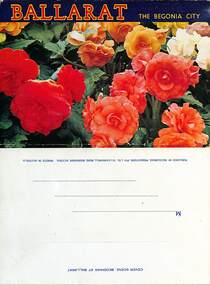
Postcard - Folder Set, Nu-color-vue or Nucolorvue Productions, "Ballarat the Begonia City", early 1960s
Published by Nucolorvue Productions of Moorabbin Vic. Features photos the Imperial Crown at the Shell House, Ballarat Post Office, looking west up Sturt St with a number of trams in the City Loop. It would appear that the trams have been fitted with dash canopy lightings which dates the photo to early 1960s to mid 1960s. As well Eureka Stockade, Civic Hall, Lake Wendouree, Bridge St from Stones Corner that shows the tramway overhead and signals, Arch of Victory, Sturt St Statuary and Gardens, Begonia House, The Gardens and the Floral Clock with the Town or City Hall. Demonstrates a postcard folder produced by Nucolorvue.Printed colour postcard folder titled "Ballarat The Begonia City", featuring a photo of begonias on the cover and an address box on the rear of the folder.sturt st, city loop, postcards, gardens, lake wendouree, begonias, eureka stockade, shell house -
 Bayside Gallery - Bayside City Council Art & Heritage Collection
Photograph - gelatin silver photograph, Sarony & Co, The Councillors and Officers of the first City of Sandringham Council, 1923
This photograph records the Councillors and officers on the day that the Town of Sandringham became a City, and the first meeting of the City of Sandringham Council was held. Sandringham was originally part of the Shire of Moorabbin. On 28 February 1917, Sandringham was severed from Moorabbin and incorporated as the Borough of Sandringham. It was proclaimed a Town on 9 April 1919 and a City on 21 March 1923. city of sandringham, councillors, local government, municipality, mayor, cr. h.b. grace, cr. w.h. kay, cr. j.m. ramsay, cr. f.n. gibbs, cr. g.w. knott, cr. r. chisholm, t.g. farrant, cr. c.a. hartsmann, m.h.t. williams, town clerk, cr. j.t.d. beck, m.w.t. sanderland, surveyor -
 Bayside Gallery - Bayside City Council Art & Heritage Collection
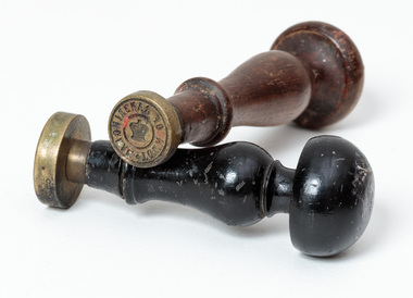
Ceremonial object - Seal, Town of Sandringham and City of Sandringham seals
Council's seals were stamped into hot wax to officialise documents. Sandringham was originally part of the Shire of Moorabbin. On 28 February 1917, Sandringham was severed from Moorabbin and incorporated as the Borough of Sandringham. It was proclaimed a Town on 9 April 1919 and a City on 21 March 1923.Two round brass seals on wooden handles. The longer brown wooden handle seal reads around edge 'TOWN OF SANDRINGHAM' with an illustration of St Edward's crown in centre. The black wooden-handled seal reads around edge 'CITY OF SANDRINGHAM' with an illustration of St Edward's crown in centre. Both seals have mushroom-shaped tops and tapered arms.There are remnants of red wax on both seals.seal, common seal, stamp, town of sandringham, city of sandringham, writing accessory, wax seal, bayside -
 Bayside Gallery - Bayside City Council Art & Heritage Collection
Map, Department of Crown Lands and Survey et al, Moorabbin, County of Bourke, Government Roads, 1920
The cadastral map of the Parish of Moorabbin in Victoria (L.6104) shows parish boundaries and land ownership 1920 when Sandringham was a Town. The government roads have been coloured in red pencil.moorabbin, county of bourke, map, plan, land subdivision, land titles, foreshores, hampton, beaumaris, highett, cheltenham, department of lands and survey, land owners, cartographic material, brighton, sandringham, town of sandringham, government roads -
 Bayside Gallery - Bayside City Council Art & Heritage Collection
Map, Department of Lands and Survey, Land under the control of the City of Sandringham, 1962
... moorabbin black rock street map City of Sandringham Board of Lands ...The cadastral map showing land under the control of the City of Brighton in 1962.map, plan, foreshores, sndringham, hampton, beaumaris, cheltenham, department of lands and survey, cartographic material, moorabbin, black rock, street map, city of sandringham, board of lands and works -
 Bayside Gallery - Bayside City Council Art & Heritage Collection
Map - print, Melbourne and Metropolitan Board of Works, Interim development order: Brighton, Moorabbin and Sandringham, 1959
The Melbourne and Metropolitan Board of Works (now Melbourne Water) was established in 1891. From that time, as part of their work laying water and sewerage connections, they created detailed plans of houses and other buildings in the Melbourne metropolitan area. In 1956 it acquired powers to construct and maintain highways and bridges, protect and improve the foreshores and create and maintain parks within the metropolitan region. This Interim development order comprises part of the municipalities of Brighton, Moorabbin and Sandringham and was made on 20 October 1959.brighton, moorabbin, sandringham, melbourne and metropolitan board of works, map, town planning, cartographic material, interim development order, bayside -
 Bayside Gallery - Bayside City Council Art & Heritage Collection
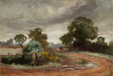
Painting - oil on canvas on board, Charles Douglas Richardson, After the rain, Moorabbin, 1910
oil on canvas on boardlandscape, moorabbin, road, charles douglas richardson, horse, cart, tree, farm -
 Bayside Gallery - Bayside City Council Art & Heritage Collection
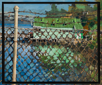
Painting - acrylic on canvas, Mike Green, Keefers, 1976
In the early 1900s, Melbourne builder Charles Keefer was hired by the Moorabbin Council to build the municipal baths at Beaumaris. In 1903, Keefer took over the Beaumaris Boat House and enlarged it to form Keefer's Boat Shed where day trippers and holiday makers could hire boats and venture out into the bay. Although rebuilt following the devastating storms in 1934, Keefer’s Boat Shed was completely destroyed by fire in 1984.Realismkeefer's, boatshed, bayside, coast, beaumaris, fence, water, bay, charles keefer, pier, mike green -
 Bayside Gallery - Bayside City Council Art & Heritage Collection
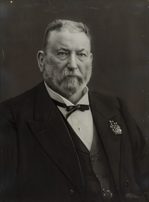
Photograph - gelatin silver photograph, Talma & Co, Sir Thomas Bent, c. 1907
sir thomas bent, thomas bent, speaker, mayor, premier, brighton, moorabbin, land speculator, local government, councillor, official, member of lower house, portrait, parliament -
 Bayside Gallery - Bayside City Council Art & Heritage Collection
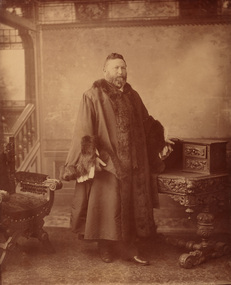
Photograph - sepia photograph, Councillor Thomas Bent, Mayor of Brighton
thomas bent, politician, mayor, premier, land speculator, speaker, local government, councillor, member of lower house, portrait, brighton, moorabbin, mayoral robes, mayor of brighton, premier of victoria -
 Bayside Gallery - Bayside City Council Art & Heritage Collection
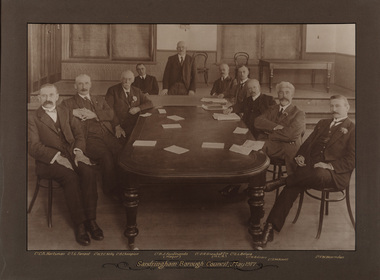
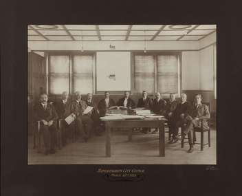
Photograph - sepia photograph, Frazer and Vallance, Sandringham Borough Council, May 1917, 1917
Councillors and the mayor seated at table while attending the first Sandringham Borough Council meeting after severance from the Shire of Moorabbin. Shown L to R: Cr. C.A. Hartsman; Cr. T.G. Farrant; Cr. W.T.C. Kelly; Cr. B. Champion; Cr. B.J. Ferdinando (Mayor) [standing]; Cr. O.R. Snowball Esq. (M.L.A.); Cr. E.L. Belyea; Cr. H. B. Grace; Cr. G.W. Knott; Cr. F.W. Hearnden.councillor, sandringham, local government, municipality, mayor, justice of the peace, cr b.j. ferdinando, borough of sandringham, cr. c.a. hartsman, cr. t.g. farrant, cr. w.t.c. kelly, cr. b. champion, cr. o.r. snowball, cr. e.l. belyea, cr. h. b. grace, cr. g.w. knott, cr. f.w. hearnden, council meeting -
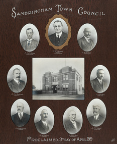 Bayside Gallery - Bayside City Council Art & Heritage Collection
Photograph - gelatin silver photograph, Talma & Co, Sandringham Town Council, Proclaimed 9th day of April,1919, 1919
Sandringham was originally part of the Shire of Moorabbin. On 28 February 1917, Sandringham was severed from Moorabbin and incorporated as the Borough of Sandringham. It was proclaimed a Town on 9 April 1919 and a City on 21 March 1923. The Sandringham Town Hall, located on Abbott Street, Sandringham (formerly the mechanics institute) was demolished in 1994.councillor, sandringham, local government, municipality, mayor, portrait, city of sandringham, sandringham town hall, abbott street, cr. e.l. belyea, cr. b. champion, cr. h.b. grace, cr. c.a. hartsman, cr. j.e.d. beck, cr. b.j. ferdinado, cr. t.g. farrant, cr. w.t.c. kelly, cr. g.w. knott, town, proclamation, bayside, hampton, black rock -
 Bayside Gallery - Bayside City Council Art & Heritage Collection
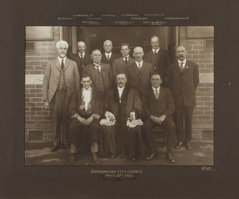
Photograph - gelatin silver photograph, Sarony & Co, The first meeting of the City of Sandringham Council, 21st March, 1923, 1923
Photograph taken on the day that the Town of Sandringham became a City, and the first meeting of the City of Sandringham Council. Sandringham was originally part of the Shire of Moorabbin. On 28 February 1917, Sandringham was severed from Moorabbin and incorporated as the Borough of Sandringham. It was proclaimed a Town on 9 April 1919 and a City on 21 March 1923.councillor, sandringham, local government, municipality, mayor, cr. c.a. hartsman, cr. t.g. farrant, cr. g.w. knott, cr. f.n. gibbs, h.t. williams, town clerk, engineer, cr. j.t.d. beck, b.r. sunderland, cr. w.h. kay, cr. r. chisholm, cr. h.b. grace, cr. j.m. ramsay, city, proclamation, council meeting, city of sandringham -
 Bayside Gallery - Bayside City Council Art & Heritage Collection
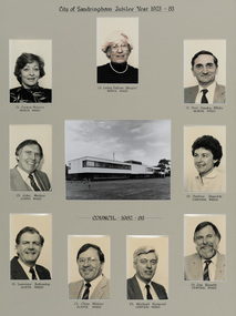
Photograph, City of Sandringham Jubilee Year 1923-83, 1983
Sandringham was originally part of the Shire of Moorabbin. On 28 February 1917, Sandringham was severed from Moorabbin and incorporated as the Borough of Sandringham. It was proclaimed a Town on 9 April 1919 and a City on 21 March 1923. This compilation marks the Jubilee year of the City of Sandringham.sandringham municipal office, councillor, mayor, portrait, municipal building, sandringham, bayside, cr. carmen watson, cr. lesley falloon, cr. paul gundry-white, cr. john merkus, cr. pauline reynolds, cr. laurence bottomly, cr. clem waters, cr. michael harwood, cr. jim bissett, jubilee year -
 Bayside Gallery - Bayside City Council Art & Heritage Collection
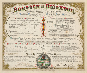
Certificate - Illuminated certificate, Hamel & Fergsuon, Brighton Municipal Certificate, 1866
bayside city council, borough of brighton, illuminated, certificate, population, rates, public buildings, mayor, town clerk, surveyor, councillors, council, borough, county of bourke, thomas crisp, cr t. crisp, census, parish of moorabbin, hamel & ferguson, coat of arms -
 Bayside Gallery - Bayside City Council Art & Heritage Collection
Map, Department of Crown Lands and Survey, Moorabbin, County of Bourke, c. 1918
The cadastral map of the Parish of Moorabbin in Victoria (L.6104) shows parish boundaries and land ownership c. 1918 when Sandringham was a Borough.moorabbin, county of bourke, map, plan, land subdivision, land titles, foreshores, sndringham, hampton, beaumaris, highett, cheltenham, department of lands and survey, land owners, cartographic material, borough of sandringham, brighton -
 Bayside Gallery - Bayside City Council Art & Heritage Collection
Map, Department of Crown Lands and Survey, Melbourne and Suburbs, City of Sandringham, 1917-1926
... of sandringham moorabbin black rock street map City of Sandringham ...map, plan, foreshores, sndringham, hampton, beaumaris, cheltenham, department of lands and survey, cartographic material, borough of sandringham, moorabbin, black rock, street map, city of sandringham -
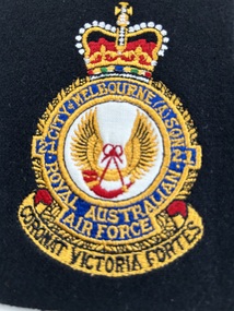 Moorabbin Air Museum
Badge (Item) - RAAF 21 Squadron Crest City Of Melbourne Patch
-
 Kew Historical Society Inc
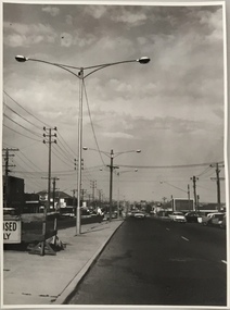
Photograph, Stuart Tompkins Studio, Electricity Supply Poles, South Road, Moorabbin, 1965
Research provided by Stuart Tompkins Studio, Box Hill, into alternatives for median strip street lighting to be used in Burke Road, Kew. The photographers identified variants in different suburbs appropriate to Kew's needs.The series from which the photograph is drawn provides a snapshot by a commercial photographic studio of each named vicinity in 1965 as well as providing examples of public works infrastructure being commissioned by local government in the 1960s. The photos originally formed part of the Engineering Department's files in the City of Kew before being donated to the kew Historical Society.Electricity Supply Poles, South Road, Moorabbin, 1965. Stuart Tompkins Studio provided this photograph for the Kew City Council. The photograph of South Road, Moorabbin, west of Jasper Road, looking east depicts steel poles with two lamps in a median strip and supply wires from pole to pole. The poles were described as 100′ apart. The notation on the rear of the photograph was that there were lamps along the median strip except at intersections. A wooden pole is recognised as supporting heavy supply lines across the road. The steel poles in the photograph were said to be between 3′ to 3.5′ whereas the wooden poles were three to 12.25″ in diameter. [There are three copies of this photograph in the Collection.] Typed inscription on reverse: "Electricity Supply Poles. Photographed for Kew City Council 8/2/65. No.2 South Road - Moorabbin, west of Jasper Road, looking east. Steel poles with two lamps in median strip and supply wires from pole to pole along median strip (poles only 100' apart). Lamps along median only except at intersections. Wooden pole supports heavy supply lines across the road. Wooden poles 3' up and 8 1/2" dia. Wooden poles 3' up and 12 1/2 dia." Studio stamp: "Stuart Tompkins Studio. 547 Station Street, Box Hill. WX1439."public infrastructure -- kew (vic.), city of kew - engineers department -
 Kew Historical Society Inc
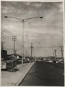
Photograph, Stuart Tompkins Studio, Electricity Supply Poles, South Road, Moorabbin, 1965
Research provided by Stuart Tompkins Studio, Box Hill, into alternatives for median strip street lighting to be used in Burke Road, Kew. The photographers identified variants in different suburbs appropriate to Kew's needs.The series from which the photograph is drawn provides a snapshot by a commercial photographic studio of each named vicinity in 1965 as well as providing examples of public works infrastructure being commissioned by local government in the 1960s. The photos originally formed part of the Engineering Department's files in the City of Kew before being donated to the kew Historical Society.Electricity Supply Poles, South Road, Moorabbin, 1965. Stuart Tompkins Studio provided this photograph for the Kew City Council. The photograph of South Road, Moorabbin, west of Jasper Road, looking east depicts steel poles with two lamps in a median strip and supply wires from pole to pole. The poles were described as 100′ apart. The notation on the rear of the photograph was that there were lamps along the median strip except at intersections. A wooden pole is recognised as supporting heavy supply lines across the road. The steel poles in the photograph were said to be between 3′ to 3.5′ whereas the wooden poles were three to 12.25″ in diameter. [There are three copies of this photograph in the Collection.] Typed inscription on reverse: "Electricity Supply Poles. Photographed for Kew City Council 8/2/65. No.2 South Road - Moorabbin, west of Jasper Road, looking east. Steel poles with two lamps in median strip and supply wires from pole to pole along median strip (poles only 100' apart). Lamps along median only except at intersections. Wooden pole supports heavy supply lines across the road. Wooden poles 3' up and 8 1/2" dia. Wooden poles 3' up and 12 1/2 dia." Studio stamp: "Stuart Tompkins Studio. 547 Station Street, Box Hill. WX1439."city of kew -- engineers department, public infrastructure -- kew (vic.) -
 Kew Historical Society Inc
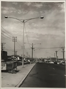
Photograph, Stuart Tompkins Studio, Electricity Supply Poles, South Road, Moorabbin, 1965
Research provided by Stuart Tompkins Studio, Box Hill, into alternatives for median strip street lighting to be used in Burke Road, Kew. The photographers identified variants in different suburbs appropriate to Kew's needs.The series from which the photograph is drawn provides a snapshot by a commercial photographic studio of each named vicinity in 1965 as well as providing examples of public works infrastructure being commissioned by local government in the 1960s. The photos originally formed part of the Engineering Department's files in the City of Kew before being donated to the kew Historical Society.Electricity Supply Poles, South Road, Moorabbin, 1965. Stuart Tompkins Studio provided this photograph for the Kew City Council. The photograph of South Road, Moorabbin, west of Jasper Road, looking east depicts steel poles with two lamps in a median strip and supply wires from pole to pole. The poles were described as 100′ apart. The notation on the rear of the photograph was that there were lamps along the median strip except at intersections. A wooden pole is recognised as supporting heavy supply lines across the road. The steel poles in the photograph were said to be between 3′ to 3.5′ whereas the wooden poles were three to 12.25″ in diameter. [There are three copies of this photograph in the Collection.] Typed inscription on reverse: "Electricity Supply Poles. Photographed for Kew City Council 8/2/65. No.2 South Road - Moorabbin, west of Jasper Road, looking east. Steel poles with two lamps in median strip and supply wires from pole to pole along median strip (poles only 100' apart). Lamps along median only except at intersections. Wooden pole supports heavy supply lines across the road. Wooden poles 3' up and 8 1/2" dia. Wooden poles 3' up and 12 1/2 dia." Studio stamp: "Stuart Tompkins Studio. 547 Station Street, Box Hill. WX1439."stuart tompkins studio, street lighting, south road (moorabin) 1965, public infrastructure -- city of kew, city of kew -- engineer's department -
 Glen Eira City Council History and Heritage Collection
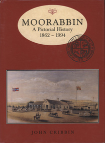
Book, "Moorabbin: A Pictorial History, 1862 - 1994", 1995
Copy of pictorial history book written by John Cribbin significantly signed by councillors and the author on the first page.The words "Moorabbin: A Pictorial History, 1862 - 1994" printed in brown colour in and oval at the top of a red, hard paper cover book, copy of an image of horse and carts and Gregg's Plough and Harrow Hotel, South Brighton below. Below that name of author "John Cribbin" is printed. -
 Glen Eira City Council History and Heritage Collection
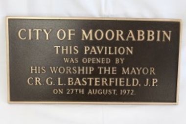
Plaque, commemorative
Plaque, bronze rectangular with polished bronze border and relief lettering and brown textured background. The plaque commemorates the opening of the Moorabbin Pavilion by the Mayor CR G. L. Basterfield J.P. on the 27th August 1972. Inscription: City of Moorabin / This pavilion / was opened by / his worship the mayor / CR. G. L. Basterfield J.P / on 27th August 1972. -
 Victorian Bands' League
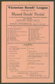
Flyer /Pamphlet / Programme, 1933
... junior malvern tramways band stonnington city brass coburg west ...The Victorian Bands' League was officially founded on the 10th of April, 1931. This new organisation quickly gained the affliations of all brass bands in Victoria and took over the control of bands from the Victorian Bands' Association. The new VBL started presenting massed bands events at the MCG and ran competitions around Victoria. This program pamphlet is a unique example of the style of massed bands events that were held at the MCG with 24 brass bands all marching into the ground and performing a number of items individually or in groups. This would have been quite a spectacle! This small program is very significant to the banding history in Victoria. It provides a wealth of information as to the bands that existed in 1933 as well as what they played, and how the VBL organised events. As well as this, there is evidence of a large number of metropolitan bands as well as bands from country areas.Small printed pamphlet on thin paper.victorian bands' league, melbourne cricket ground, malvern tramway junior, malvern tramways band, stonnington city brass, coburg west boys, prahran city, kingsville and yarraville citizens', footscray city, footscray-yarraville city brass, coburg city, northcote citizens and soldiers', essendon citizens', moonee valley brass band, geelong city, terang brass, geelong west city, south melbourne city, reservoir citizens', st. kilda city, oakleigh city, oakleigh band, hawthorn city, kensington district, brunswick city, moreland city band, moorabbin shire, metropolitan fire brigade, sunshine district, sunshine community brass, kew city, kynetown town -
 City of Kingston
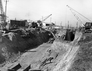
Photograph - Black and white, c. 1958
... in what is now the City of Kingston. Moorabbin Railway station ...Moorabbin station sits on the Frankston line which first opened in 1882 when the line was extended from Mordialloc. Moorabbin station opened in 1881 and was originally called South Brighton station. It was renamed Moorabbin station in 1907. In 1958 the station was relocated below street level which coincided with other construction works on Nepean Highway and South Road. This image is part of a larger collection of images from the Public Transport Corporation displaying train stations and streetscapes in what is now the City of Kingston.Black and white photograph showing excavations for Moorabbin station to be moved below street level. Stamped in blue ink on reverse: COPYRIGHT / Public Transport Corporation / For re-ordering photographs / Please quote negative No M6004 / Enquiries C/- PTC Photographic Unit / Telephone switchboard 619 111moorabbin, railway station, construction works, suburbs, nepean highway