Showing 4515 items
matching farm
-
 Kiewa Valley Historical Society
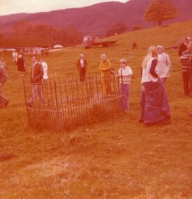
Photograph of pioneer grave, 29th May, 1977
Pictorial record of the grave of pioneer woman Mrs Mary Hollonds, who passed away in 1862. The grave is located at Mullagong Station (farm) in Tawonga, five miles south of Keegan's Bridge. Miss Hobbs, formerly of Running Creek, mentioned that twin babies of the Brigg's family are buried at Mary Holland's feet.Pictorial record of pioneer gravesites in the Kiewa Valley. Social history of people in 1977 showing interested in local historyColour photograph of group visiting the grave of pioneer woman Mrs Mary Hollands at Mullagong on 29th May, 1977Handwritten in faint blue ink on back of photograph: Mrs Mary Holland's grave. Died 1862 Mullagong. 29th May, 1977kiewa valley, mullagong station, tawonga, hollonds family, brigg's family -
 Halls Gap & Grampians Historical Society
Photograph - B/W, C 1900
In early 1900, three Emmett brothers, with support from George Mason, set about following up a report of gold in the area. Confirmation of gold led to a gold rush in June 1900. Traffic from Ararat and Willaura passed Mason's Farm and it was on Mason's land that the first settlement, Ladysmith, sprang up.Road leading to Mt William goldfield 1900. George Mason's farmhouse on right hand side of road.access routes, roads, mining, ladysmith -
 Hume City Civic Collection
Photograph, early 1980s
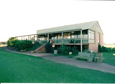
The series of photographs were taken shortly after the opening of the newly established Goona Warra Golf Club in the early 1980s. The golf club was part of the Goonawarra Housing Estate which was developed on the area previously known as Goonawarra Farm. The new golf club replaced 'The Pines' which was part of the Caloola complex.A coloured photograph of the front view of Goonawarra Golf Club's clubrooms. The building is on 2 levels with a large balcony across the front. Native plants have been planted around the building and a gravel path leads to the building.goona warra golf club, george evans collection -
 Hume City Civic Collection
Photograph, early 1980s
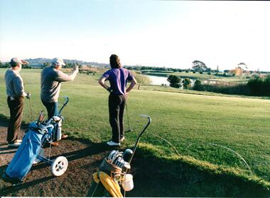
The series of photographs were taken shortly after the opening of the newly established Goona Warra Golf Club in the early 1980s. The golf club was part of the Goonawarra Housing Estate which was developed on the area previously known as Goonawarra Farm. The new golf club replaced 'The Pines' which was part of the Caloola complex.A coloured photograph of 3 men who are looking towards the lake at the Goonawarra Golf Club. Their golf buggies are behind them.goona warra golf club, george evans collection -
 Hume City Civic Collection
Photograph, early 1980s
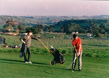
The series of photographs were taken shortly after the opening of the newly established Goona Warra Golf Club in the early 1980s. The golf club was part of the Goonawarra Housing Estate which was developed on the area previously known as Goonawarra Farm. The new golf club replaced 'The Pines' which was part of the Caloola complex.A coloured photograph of two golfers. One is preparing to hit off while the other is standing in the background with the golf buggy. They are standing overlooking the Goonawarra and Craiglea vineyards and the Jacksons Creek valley.goona warra golf club, george evans collection -
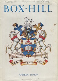 Surrey Hills Historical Society Collection
Book, Box Hill, 1978
This book looks at Box Hill as it grew from a rural backwater to a country town amid farms and orchards, then to an outer suburb, and then to an almost inner suburb. It covers the rural depression in the 1860s, the land boom of the 1880s and the collapse in the 1890s, the bitter days of two World Wars and the Depression, and the 'dry' suburb of Box Hill.Hardback book of 270 pages, indexed and footnoted, with some photos and plans; it is divided into chronological periods rather than themes."SURREY HILLS / NEIGHBOURHOOD CENTRE - HISTORY" on top of title page; "Surrey Hills Neighbourhood Centre" on top of front of jacket.box hill, dry area, temperance movement, mayors, councillors, agriculture, railways -
 Wodonga & District Historical Society Inc
Functional object - Cream Stirrers
These stirring rods with long handles and base referred to as a dasher were common in the dairy industry. They were made to agitate milk or cream in milk cans and were used on dairy farms and in old creameries. They helped to cool the milk and stop it from separating. They were used on the properties of the Conway and Lemke families in Wodonga.These items are significant as they are representative of tools used in the early dairy industry and were owned by families in Wodonga.Milk / cream stirrers made from steel with a circular blade attached to enable milk to flow through.dairy industry wodonga, dairy tools, dairy machinery -
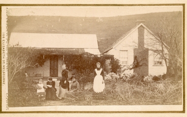 Bacchus Marsh & District Historical Society
Photograph, Group of women at a farmhouse near Bacchus Marsh 1883
This image is one of several family group portraits taken by Stevenson and McNicoll on rural properties. This property has been identified as that of John Tilley at Parwan’s Creek. The people depicted are presumably members of the Tilley family. The dwelling has since been demolished. Tilleys Road in Maddingley is probably named for this family farm.Small sepia unframed photograph on card with gold border framing photograph. Housed in the Jeremeas Family Album which contains photographs of Bacchus Marsh and District in 1883 by Stevenson and McNicoll. The property has been identified as that of John Tilley at Parwan’s Creek. This property has since been demolished. Presumably, the photo is of members of the Tilley family. The image shows a family group of four women and one young child. It is unclear if the child is a boy or a girl, due to the custom of clothing young male children in dresses. The women are sitting or standing in two groups. To the right stands an older woman in a starched white apron, perhaps indicating that she is the housekeeper. The group on the left is of one woman standing and two women seated, one reading a newspaper or magazine. The young child reaches out one arm to her, perhaps for reassurance. The dwelling consists of two structures, one single storeyed cottage, which is perhaps the older part, and an adjoining weatherboard house with a steeply pitched roof and a prominent chimney at the front. The cottage has a shingled verandah partially covered by corrugated iron, which also covers the roof. Trees, a climbing vine and shrubs form a rather unkempt garden. On the hill rising behind the farmhouse there can be seen animals, possibly sheep, grazing.On the front: Stevenson & McNicoll. Photo. 108 Elizabeth St. Melbourne. COPIES CAN BE OBTAINED AT ANY TIME. On the back: LIGHT & TRUTH inscribed on a banner surmounted by a representation of the rising sun. Copies of this Portrait can be had at any time by sending the Name and Post Office Money Order or Stamps for the amount of order to STEVENSON & McNICOLL LATE BENSON & STEVENSON, Photographers. 108 Elizabeth Street, MELBOURNE. stevenson and mcnicoll 1883 photographs of bacchus marsh and district, farmhouses, families, women bacchus marsh -
 Eltham District Historical Society Inc
Photograph, Tess Justine (Nillumbik Shire Council), Construction work on replacement of Murray's Bridge over the Diamond Creek, Eltham North, 31 Mar 2022
Construction work on replacement of Murray's Bridge over the Diamond Creek on the Diamond Creek Trail Mary (Sweeney) Murray and John Wright Murray selected 80 acres, Lot C Section 16 and Lot 5 Section 17 Parish of Nillumbik, under an occupation license in 1866. John died in 1867 and freehold was granted to his son John in 1873. The farm was known as ‘Laurel Hill’. John Junior was an Eltham Shire councillor and sometime president from 1887 up until 1897. He added Lot A Section 16 to the farm in ca1888. John and his younger brother James arranged to rent/purchase Lot B Section 17, across Diamond Creek to the west, in ca1900. It appears that John and James farmed separately for a few years, with a new homestead built for James ad family on the high point of Lot B Section 17 in ca1910. John sold off Lot 5 Section 17 in 1912. When John died in 1912 James took over the land on both sides of the Diamond Creek. The old homestead on the west side of the Creek disappeared. A farm bridge over Diamond Creek from this period may have been located close to the northern boundary of the farm. John Langlands, owner of the farm known as ‘Ihurst’ on the west side of Diamond Creek to the south of the Murray’s land, died in 1907. In 1909 his land was then subdivided into 100 lots to become the ‘Glen Park Estate’. Other similar subdivisions of nineteenth century farms around Eltham in this period included the ‘Franktonia (or Beard’s) Estate’ to the northeast and ‘Bonsack’s Estate’ between Eltham and Greensborough. Soon after the opening of the railway extension line from Eltham to Hurstbridge in 1912, Glen Park and nearby residents including James Murray agitated for a railway station or siding to be located half-way between Eltham and Hurstbridge, so that the Glen Park residents who used the railway daily did not have to walk into the Eltham or Hurstbridge stations. Some believed Coleman’s Corner (opposite Edendale Farm) was an appropriate spot for the platform. James Murray was among those who thought the railway should be located on his land, closer to half-way between Eltham and Hurstbridge stations. The Railways Commissioners warned that the locals would have to fund these works themselves. The Glen Park Estate residents initially had difficulty accessing Eltham by road, with only an old low-level bridge over Diamond Creek at the south end of their estate. A new timber trestle bridge across the creek, now on Wattletree Road, was opened in 1915. Road access to the north was gained in 1927 when the new Murray’s Road, which crossed the Murray’s land, was built. Residents continued to agitate for a Glen Park station. By 1926 the Railways Commissioners’ preferred site was on the Murray’s land. They arranged an estimate of cost of a full-length platform. The estimate was too much for the locals, who in 1928 argued unsuccessfully for a shorter and hence cheaper platform. By 1929 Murray had agreed to donate the land, but the locals would still have to fund the works. Murray decided, unilaterally it would appear, to commence work on a timber trestle road bridge over Diamond Creek to link the new Murray Road to the proposed station. Late in 1929 he stopped work on the bridge, for reasons unknown, but started work again and completed the bridge in 1931. There is no further newspaper evidence of the campaign for the Glen Park station until 1939, when Murray and another local, Mr Maxwell, met the Railways Commissioner. The Glen Park locale now included 45 homes on the west side of the creek and 20 on the Eltham side. Most of the residents used the train every day. The Commissioner remained adamant that only a full-length platform could be built for safety reasons. It appears the campaign dissolved at this point. The increasing move to cars may have had an impact. There is no evidence of Murray’s bridge ever being connected to Murray’s Road, or of it having wide use for any purpose by locals. James Murray died in 1947 and the farm was taken over by his son James (Jim). Jim started to sell off parts of the farm in the 1980s, retaining a few acres around the ca1910 homestead and building a new house there. Recreation reserves were established along the creek. In ca1990 Murray’s bridge was renovated with steel girders as part of a bike/pedestrian path in the reserve. The old farmhouse was demolished in ca2014. Born digital image (5)diamond creek (creek), diamond creek trail, murrays bridge, ‘laurel hill’, john wright murray, mary (sweeney) murra, john murray jnr, james murray, john langlands, ‘ihurst’, ‘glen park estate’, beard's estate, franktonia, bonsack's estate, glen park estate, glen park railway station -
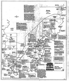 Greensborough Historical Society
Map, Heidelberg: Historic River Landscape Assessment. Historical maps. Map D 1864 -1901 "Sleepy Hollow" and "Sleeping beauty", 1985c
Geographical area of c. 35 sq. kilometres marked with physical features such as major roads, rivers, vegetation and properties, with locations and notes on the increasing number of farms, orchards and vineyards that had been developed in addition to pastoral runs. Bounded by Shire of Diamond Valley to the North, Darebin Creek to the West, and Plenty River to the East.Black and white sketch on white paper. Second copy 600 x 430 cm printed in black on semi-opaque paperheidelberg, heidelberg - maps -
 Warrnambool and District Historical Society Inc.
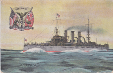
Postcard - Post, Card Georgia, c.1910
The recipient of this card, Jessie Bonnett was born in Allansford in 1897. She spent her life on the family farm at Mepunga with her brothers Jack and George. She died in 1990 and her scrapbook came into the collection of the Warrnambool and District Historical Society through her relative, Mary O’Callaghan. Nothing is known of Ada Lawlor.This card has social significance and interest showing the communication between people in an earlier age. Postcards were commonly used to convey a short message between friends. This is a postcard with an image of the ship ‘Georgia’ on the front and a letter from Nullawarre on the back. There is a stamp from the Gray’s Colosseum Stationers and a symbol, ‘F & J’ on the back. Nullawarre, 13.10.10 Miss Jessie Bonnett, Mepunga, Dear Jessie, Just a P.C. in answer to your pretty card and for being so kind in always helping me with my sums. Please excuse this P.C. as I have no other. I remain, your affect. playmate, Ada Lawlor. Dear Jess I was not at school yesterday as I was sick with a cold.jessie bonnett, ada lawlor, the georgia -
 Orbost & District Historical Society
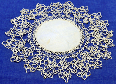
doily, late 19th -early 20th century
This doily was handmade by Penuel Cameron (nee Hossack). The Hossack family farmed land on the Marlo Road. Like the Camerons they were staunch Presbyterians. Robert Cameron was one of earliest settlers on Orbost flats and ran the paddlesteamer "Cheviot". He served many years on shire council and built the first Presbyterian. church in Orbost.This item is an example of a handcrafted item and reflects the needlework skills of women in the families of the early settlers.Hand tatted medium sized doily. Small round linen piece in centre and large tatted border.doily handcrafts needlework linen lace cameron-robert -
 Bunjil Park Aboriginal Education & Cultural Centre
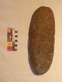
stone axehead
This stone was held by a European family for 200 years and was found on the family farm. It was gifted to Uncle Brien Nelson in Castlemaine. This implement could be many thousands of years old. This unusually large axe head would not have been carried from place to place and was probably hidden for occasional use crafting large objects.This stone axe head is shaped to a sharpened rounded edge at one end and is broad and blunt at the other end. It is an elongated teardrop shape in cross section. It has a distinctive waist in the middle where the haft was attached using hide and or fibre.This axe displays grooves caused by a disk plough.jaara, heavy stone axe head -
 City of Moorabbin Historical Society (Operating the Box Cottage Museum)
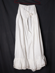
Clothing, Lady's white, long, half petticoat cotton c1900, c1900C
A Lady's white, long, cotton half petticoat with a gathered flounce and lace insert at hem. The petticoat has a placket on the side seam and is fastened with bone buttons, The pioneer families had to be self sufficient making their own tools, clothing, while developing their market gardens, fruit orchards and dairy farms in Moorabbin Shire The pioneer women in Moorabbin Shire had to make and repair the clothes for themselves and their families and were accomplished in dressmaking, needlework , craftwork and knitting A Lady's white, long, cotton half petticoat with a wide flounce lace edging and bone buttons at side seam clothing, brighton, moorabbin, pioneers, dressmaking, market gardeners, early settlers, craftwork , bentleigh, lacework, moorabbin shire blackburn nance, dairy farms, fruit orchards -
 Tatura Irrigation & Wartime Camps Museum
Photograph, Presbyterian Boys
Photos copied from Superintendent Hannan's album. Presbyterian Boys Training Farm. Dhurringile Mansion. 7 Photos. Pipe Band c.1955. Jock Lawrie, Pipe Major. Photo2- Adam Katinis, top left; Jim Brown right. Photo 4- Left Nigel Stewart; Right Les Ferguson.photograph, people, presbyterian boys training farm, dhurringile mansion, pipe band, jock lawrie, adam katinis, jim brown, nigel stewart, les ferguson -
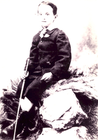
 Linton and District Historical Society Inc
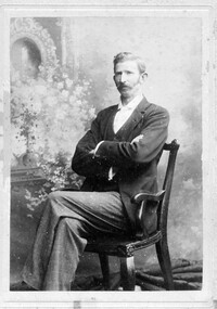
Photograph, Richards and Co. 23 Sturt St, Ballarat, Mr W.O. Lewers
William Ochiltree Lewers (1867-1943) was a son of LInton's first bank manager Samuel Lewers and his wife Annie. He farmed at “Hoyles Creek”, Mannibadar. He married Caroline Murrell (daughter of Ambrose and Mary Murrell) in 1910. They had two sons, William, b. 1910 and Samuel, b. 1911. Sepia photograph of a gentleman with moustache, wearing suit coat and trousers, seated with arms and legs crossed."Mr W.O. Lewers Snr."william ochiltree lewers -
 Hymettus Cottage & Garden Ballarat
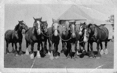
Photograph, Archie Burke's Ploughing Team Dooboobetic
Mr William Burke settled at Dooboobetic near Donald in the 1860s his sons eventually working their own farms on subdivisions of the original property. Archibald (Archie) whose team is pictured had a portion named "Inverleigh". His daughter married Mr Michael Taffe of "Hymettus" Ballarat where the photographic archive survives. small snapshot image badly creased of team with inscription and print on reverse.Written on reverse "G'pa Burke's team. with printed words KODAK PRINT and ink stamp 431 -
Warrnambool and District Historical Society Inc.
Functional object - bucket, c. 1950
A small metal bucket such as this was a common item in a household, farm or factory, 20th century and earlier. It would have been used to carry liquids such as water, milk or cleaning fluids and small loads such as feed for animals or picked fruit and vegetables. Today iron buckets are still in use but have been largely replaced by plastic ones.This bucket is retained for display purposes, perhaps in a dairy farm display.This is a galvanised iron bucket. It has as circular base with a strengthening metal strip around the edge and a tapered body with a circular top. A metal handle is inserted into small metal loops on the sides. There is some rusting in the inside base area.household items, dairy farm implements -
 Warrnambool and District Historical Society Inc.
Household, Bean Slicer
This bean slicer is one of the household labour-saving devices that became increasingly popular in the early to mid 20th century. In those times vegetables such as beans were often grown in the backyard of a house or farm and bean-cutting was a laborious task, especially when providing for a large family. Processed sliced beans were not then freely available.This bean slicer has no known local provenance but is retained as an interesting example of a 20th century household labour-saving device. This is a metal object with a round disc with three metal blades underneath on a turntable for slicing. The blades are attached by six screws. There are two funnels on the top of the disc for inserting the beans. A handle that turns the blades is attached by a screw to the round disc. Attached to the disc also is a vice that enables the slicer to be bolted to a bench or table. The slicer has been painted green but the paint is wearing off and the whole object is rustywarrnambool, bean slicer, household items -
 Warrnambool and District Historical Society Inc.
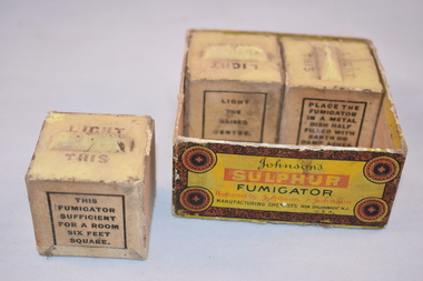
Household item, Sulphur Fumigator Cubes (boxed), Early 20th century
These sulphur fumigator cubes were used in the past to fumigate areas in such places as hospitals, plant nurseries, farms and homes. The cube was placed in a tin containing soil and the top wick was set alight and the cube would burn overnight and kill off insects, mites and germs. One cube was sufficient for a room six feet square. This is a square cardboard box with no lid. The box is brown with orange, red and black printing. The box contains three cubes of sulphur fumigators. There should be four but one cube is missing. The cubes are square-shaped with beige-coloured sides and yellow tops. The tops have raised sections which serve as wicks. ‘Light This’ ‘Johnson’s Sulphur Fumigator prepared by Johnson & Johnson, Manufacturing Chemists’ household items, history of warrnambool -
 Eltham District Historical Society Inc
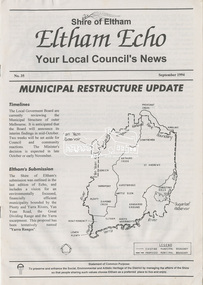
Newsletter, Eltham Echo; Your Local Council's News, Shire of Eltham, No. 35, September 1994, 1994
Feature articles include: . Municipal Restructure Update . Invasive Plants in Eltham . Capital Works program 1994/95 . A Healthy Choice of Books at Eltham Library . Eltham Community Festival '94 "Echoes of Eltham" . What's New in Building? . Leisure Centre Works Proceeding... . Edendale Community Farm . Disabled But Not Damaged: A Family Story8 page newsletter; 2 x A3 pages copy folded and stapled1994, council amalgamation, edendale community farm, eltham echo, eltham festival, eltham library, international year of the family, leisure centre, municipal restructuring, shire of eltham building services, short story competition -
 Eltham District Historical Society Inc
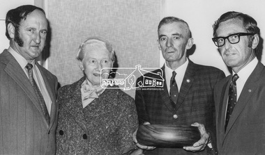
Photograph, Diamond Valley News, Shire of Eltham, Fire Prevention Week Winners Mrs. Toogood and Mr. MacMillan, 1971
Presentation being made to Shire of Eltham Fire Prevention Week 1971 Winners L-R: Mr. K. Griffith (Lower Yarra Group - Rural Fire Brigades), Mrs. Toogood - Winner Residential Section, Mr. MacMaillan - Winner Farm Section (Ex-Councillor of Shire of Eltham) and Cr. Dreverman - Shire PresidentThis photo forms part of a collection of photographs gathered by the Shire of Eltham for their centenary project book, "Pioneers and Painters: 100 years of the Shire of Eltham" by Alan Marshall (1971). The collection of over 500 images is held in partnership between Eltham District Historical Society and Yarra Plenty Regional Library (Eltham Library) and is now formally known as 'The Shire of Eltham Pioneers Photograph Collection.' It is significant in being the first community sourced collection representing the places and people of the Shire's first one hundred years.Digital image Print 10 x 16 cm (Held at Eltham Library)sepp, shire of eltham pioneers photograph collection, eltham, fire prevention week, mrs toogood, mr macmillan, k. griffith, cr. dreverman, rural fire brigade, councillors -
 Greensborough Historical Society
Map, Heidelberg. Historic River Landscape Assessment. Historical maps: Map C 1851-1863. "The Garden of the colony", 1985c
Geographical area of around 35 sq. kilometres marked with physical features such as major roads, vegetation and properties, with locations and notes of the increasing number of farms, gardens orchards and vineyards which had become established in addition to pastoral runs. Bounded by Shire of Diamond Valley to the North, Darebin Creek to the West and Plenty River to the East.Black and white sketch map on white paperheidelberg, heidelberg - maps -
 Eltham District Historical Society Inc
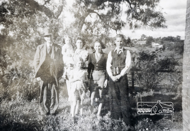
Photograph, Pa, Greta & family (perhaps Crozier?)
Photo depicts possibly a family group of six of various ages standing in bush setting with buildings in the background. Verso inscription: Pa, Greta & family Cnr Susan & Bridge [Streets]. Is this photograph relating to the Crozier Farm House? This was located at this site 66 Susan Street till 2007 when it was demolished by Nillumbik Shire Council. Black and white photograph printed with white borders (one of a set of five). -
 Eltham District Historical Society Inc
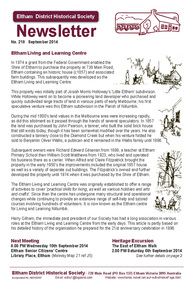
Newsletter, Newsletter, No. 218 September 2014
Contents: • Eltham Living and Learning Centre • September Meeting • September Excursion - East of Eltham Walk • Have you discovered Trove? by Liz Pidgeon • Fabbro Farm Art Project • Eltham Library - 20th Anniversary Celebration • Henry Gilbert Jones: an early Eltham settler........and an amazing coincidence by Michael Aitken • Street by Street The Shire of Eltham Historical Society was formed in October 1967. The first newsletter of the Society was issued May 1978 and has been published continuously ever since on a bi-monthly basis. With the cessation of the Shire of Eltham in late 1994, the Society's name was revised to Eltham District Historical Society and this name first appeared with issue No. 103, July 1995. The collection of the Society's newsletters provides a valuable resource on the history of the Society's activities, office bearers and committee members, guest speakers and subjects of historical interest pertinent to the former Shire of Eltham and the Eltham District.A4 photocopied newsletter distributed to membersnewsletter, eltham district historical society, shire of eltham historical society -
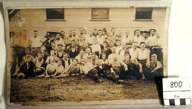 Myrtleford and District Historical Society
Hop Growers Photograph, "Panlook Boys, 1934"
The photograph represents the migratory labour force involved in hop growing, the major farm activity on "Panlook's Hop Gardens", Eurobin in 1934. William Panlook a descendant of a Chinese storekeeper on the Buckland Diggings, had originally commenced tobacco growing at the location until devastating frosts and unreliable tobacco prices brought a change in land use. The photograph represents the transition that occurred from tobacco to hops cultivation in the early 1930s. It is now a permanent feature of the farming landscape at Eurobin. It depicts the reliance on migratory seasonal labour and the importance of local expertise, some of Chinese descent. A sepia-coloured photograph of 30 hop pickers.Inscription: "The Panlook Boys, 1934"hop growing. panlooks hop gardens. eurobin -
Tatura Irrigation & Wartime Camps Museum
Photograph
Photos from Superintendent Hannan's album. Presbyterian Boys Training Farm.|Dhurringile Mansion.|5 photos.|Photo 2, Centre Left: Neville Densley; John Pilgrim.|Photo 3, Centre centre Robyn French; Centre Bottom- Terry Hawes.|Photo 4. Bottom Left Eric & Ray Brunton 1953.photograph, people -
 Ballarat Heritage Services
Photograph - Photograph - Black and White, Paul Invernizzi of Yandoit Creek
Paul Invernizzi and his sister left Victoria for Western Australia. "INVERNIZZI (Paul), age about 31 years, navvy or farm laborer ; last heard of at Narrogin last year, when he expressed his intention of going to Kalgoorlie to work on the Transcon tinental railway line. " (The Kalgoorlie Sun, 15 June .1913.)Photographic portrait of Paul Invernizzi of Yandoit Creek. After being orphaned he went to live with his uncle Giovanni Brusaschi at Dunach near Clunes. yandoit creek, yandoit hills, invernizzi, clunes, paul invernizzi, dunach -
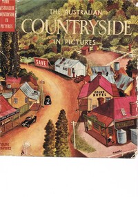 Kiewa Valley Historical Society
Book - Reference Countryside, The Australian Countryside in Pictures, circa 1950s
This book is a "snapshot" in time (1950s) detailing life in Australia covering a time when a "man's word and handshake" were his moral and quasi legal bond, and the now relative defunct saying "smoko" (having a "time out" from work for a cigarette and tea or coffee). The book spans an era where the male was still the "head" of the family even though for a majority of families the women took on the many "male only" roles during the World War II period. This shift in the leadership of the family hierarchy is mentioned, so ever slightly, (not to offend the still predominant macho male image) in both rural and city environments. The effects of the war, and later the push for women's emancipation and equality in both family, social, workplace and political areas of life, since this book was published, is now finally resolved. However there are still some sections of the recent migrate population where this male dominance is causing a few problems.The significance of this book is not only because it was donated by Mrs C. Roper ( from the Roper Family, a pioneer Kiewa Valley and surrounding Region family - originally beef cattle graziers) but also a Kiewa Valley resident and family, experiencing the shift in the social and economical life of post World War II rural Australia. The strong heritage link to this region of many families still residing within its boundaries, is a clear affirmation of the bond that the Kiewa Valley and its Regions have upon family unity. This unity within the rural environment is something that is attracting more and more families from sometimes alienating city life.This printed coloured sketched, or painted paper sleeve of the book is freely wrapped over a dark red hard cover. Into the front of the cover is pressed a standing pose of a farmer with long sleeves rolled up over his elbows. Behind him and to the right are what appears to be three sacks of wheat and next to him is a merino sheep. To the left and down are two dogs one with a fox in its jaws. The book contains 240 pages, 300 illustrations in gravure and 25 pictures in full colour. The inside fly leaf is a colour photograph of a rural scene with dirt road running in the centre and to the left a farm house and a five bay open storage barnOn the tittle page is a signature "C Roper"country life, australian "outback", rural industries, life on the land, swag-man of the bush -
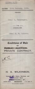 Bendigo Historical Society Inc.
Document - H.A. & S.R. WILKINSON COLLECTION: CONTRACT OF SALE
Conditions of sale by private contract dated 11th January, 1938 between Mrs. E. Banninger (seller) and Mrs. M.M. Spicer (buyer) for land situate in Wood Street, Long Gully, being Crown allotment 1 section P described in Crown grant volume 2129 folio 425693, together with 5-roomed weatherboard dwelling and all sundry, also bath, cement troughs and copper, wire doors, three venetian blinds, built in wardrobe, and vendor's interest in poultry pens built on land adjoining the above freehold, also all poultry and poultry farm equipment as per schedule on page 2. Price 550 pounds.organization, business, h.a. & s.r wilkinson real estate