Showing 285 items matching "bricks and tiles"
-
 Surrey Hills Historical Society Collection
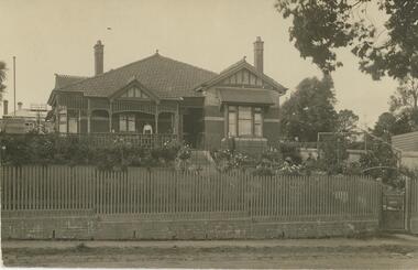
Photograph, Home and surgery of Dr William Langley Carrington, 174 Union Road, 1935
The building was erected in c 1913 as a home / surgery for Dr James L Blakie (1868-1937), who originally lived / practised across the road. It was designed by architect Arthur William Plaisted (1890-1965) and is an early example of attic-style Californian bungalow style. Dr Carrington ( 1900-1970) succeeded Dr Blakie and practised at 174 Union Road from 1930-1970. Now known as the Surrey Hills Medical Centre.Black and white photo of the surgery and home of Dr and Mrs William Langley Carrington at 174 Union Road on the corner of Guildford Road, Surrey Hills.. The exterior of the building is decorated with paper lanterns around the windows and veranda for the Empire Day celebrations in 1935. The building is 2 storey, of brick construction with a tiled roof and front porch. It has a bay window front right. Shadows indicate the photo was taken early morning in winter.medical services, guildford road, union road, dr william langley carrington, mr arthur plaisted, dr james landells blakie, californian bungalow, dr bill carrington -
 Bacchus Marsh & District Historical Society
Ceramic, Tile manufactured by Darley Firebrick Company
The manufacture of firebricks is believed to have begun in Bacchus Marsh in the 1880s when William Thomas Wittick in partnership with a Mr Ackers, and later a Mr Telford, quarried a rich deposit of fire clay at Darley. In 1902 financial assistance was provided by David Mitchell a significant businessman and contractor from Melbourne and the business then expanded and became a major supplier of refractories for gas works in Melbourne, with side lines in moulded fire bricks for foundries and smelting furnaces and complete kiln lines for potteries. The business traded under the name Darley Firebrick Company and later as Darley Refractories Ptd Ltd and was in business for over 100 years. The tile (aka refractory) described in this record was possibly produced for use in very high temperatures (in excess of 1,000°F [538°C]) encountered in modern manufacturing. More heat-resistant than metals, they are used to line the hot surfaces found inside many industrial processes. The date the tile was produced is unknown.Rectangle shaped ceramic tile'Darley 26' inscribed within a circledarley firebrick company, refractory materials, wittick family bacchus marsh, william thomas wittick 1857-1939, darley refractories ptd ltd -
 Hume City Civic Collection
Photograph, c. 1980's
The original single storey hotel was built by the vigneron, F. F. Bubeck. The hotel was destroyed by fire in 1901 and the present red brick building was built by George Millett. The hotel provided meals and accommodation for rail travellers.A coloured photograph of the Royal Hotel which is situated on the sw corner of Brook and Evans Streets. A grey car is angle parked on the LHS of the photograph and there is a line of plane treet around the curbside. The 2 storey hotel has red brick walls with cream trim around the windows and blue shutters on the windows on the upper storey. The roof is clad with terracotta tiles. Facing Brook and Evans Streets on the roof line are the parapets with the words 'Royal Hotel' on them.ROYAL HOTELevans street, brook street, bubeck, f.f., millett, george, royal hotel, george evans collection -
 Royal District Nursing Service (now known as Bolton Clarke)
Photograph - Digital image, c.1930
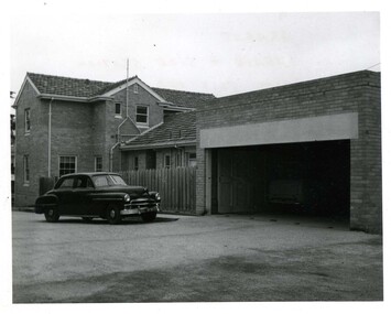
The Melbourne District Nursing Society After-Care Home was built in 1926 to give short term care to MDNS patients who were too ill to remain in their home, but not ill enough to go to hospital. Melbourne hospitals also sent patients there who required further care after discharge from hospital. After convalescence they returned to their homes. Many children were nursed there, particularly during the Polio epidemic.The Society were pioneers in recognizing the need for premises where patients too ill to be in their own home, but not ill enough to go to hospital, was needed, and the Society built, then opened, the After-Care Home in 1926, (from 1934 called After-Care Hospital), for these patients, and patients from Hospitals. Many children were nursed there, some long term, during the Polio epidemic and the Society employed two School Teachers. The Society now ran two divisions, the After-Care with its own Trained nurses and the District division. The Society were the first in Melbourne, in early 1928, to recognize some patients leaving the After-Care, and many at home, needed further social care and they set up ‘Almoners’ from their Committee to visit these patients and be intermediaries in getting them social assistance. It was late the following year before the first training of Almoners took place in Melbourne. In 1930 the Society employed a full time kindergarten teacher to visit poor children in their homes. That year the Society were pioneers in opening an Ante-Natal Clinic at the After-Care, setting a high standard with equipment, keeping records and providing leaflets with instructions in how to keep healthy during pregnancy, what complications to look for, and what to do when labour commenced. In 1934 the Society were pioneers again when they opened the first Women’s Welfare Clinic in Melbourne giving advice on birth-control, at first attended by their own patients, but then accepting patients from public hospitals until their own clinics were opened. A trained Almoner was employed, but left after twelve months due to the amount of work required. Trained Almoners were in short supply so a Social Service Officer was employed at the After-Care who successfully gained better housing from the Housing Commission for families living under unsuitable conditions. In the 1950s the Hospital and Charities Commission decided to take over the After-Care Hospital, so the Melbourne District Nursing Society and After-Care Hospital separated and the Melbourne District Nursing Service was formed, setting up Headquarters at 452 St. Kilda Road. In 1966 Royal patronage was given and the name changed to Royal District Nursing Service (RDNS).Digital image of the rear of the extended Melbourne District Nursing Society After-Care Home 45 Victoria Parade, Collingwood. It shows a three story brick building with a tiled hip roof and open verandas running along each story with windows seen behind. A zigzag stair case runs down the left hand side of the building and on the right hand side of the image you can see a section set back with one window on each floor. Behind this section, part of another multi story building is seen. A wooden paling fence is seen in the foreground of the photograph. On the far right, part of another brick building with hip roof can be seen melbourne district nursing society, mdns, melbourne district nursing society and after-care home, rdns, royal district nursing service -
 Surrey Hills Historical Society Collection
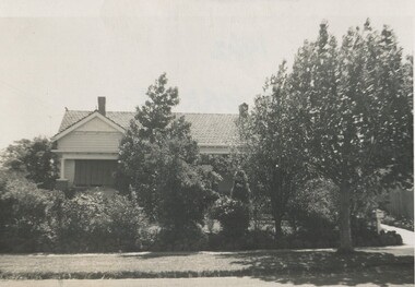
Photograph, 11 York Street, Mont Albert, 1962, 1974
This is the home of Ernest Lance Young and Beryl Mair and the childhood home of their children Barbara, Ken and Laurie. Lance was born 24 March 1915 in Surrey Hills, the son of Ernest Augustus Young and Ruby Nichell Whitby. He married Beryl Mair in 1939 and died on 5 October 1999 at Mont Albert. Electoral rolls list him as a manufacturer. His address after marriage was 11 York Street, Mont Albert. He is buried in Box Hill Cemetery (M-*-0867) along with his father. He served in WW2 (Service Number - VX104733 enlisting at St Kilda) and after returning took over his father's business. The Mair family were resident in Barton Street for several generations. Beryl's father Dave Mair was a keen sportsman and founder of the Kangaroo Social Club of cricketers. This is part of a large collection relating to the Mair, Deakin and Young families. Black & white photo of the street view of 11 York Street, Mont Albert. Although the house is heavily screened by a mature garden with several large trees or shrubs, part of the front can be seen. It is Californian bungalow in style with typical features including a terracotta tiled roof, simple roof finials, simple chimneys, shingle detail to the gable and brick and rounded pillar supports to the veranda. The front fence is low and constructed from roughly dressed stone.In black texta colour and black biro on rear: "1962 / 11 YORK ST/ MONT ALBERT" ken young, barbara young, laurie young, laurie newton, beryl mair, ernest lance young, lance young, york street, mont albert -
 Wodonga & District Historical Society Inc
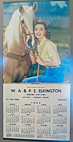
Ephemera - Sunnyside Cash Store Calendar, 1963
Sunnyside Cash Store was located on the corner of High Street and Wilson Streets Wodonga. It was built and operated by Bill and Ethel Elkington about 1947. The building is in Art Deco style with an awning, verandah and rendered brick parapet behind which was a pitched roof. The shop front originally featured black tile surrounds which have since been removed. The Ice Cream Cone at the front of the building was unfortunately stolen. Apart from a brief period in the early 2000s, the premises has operated as a corner store or café continuously since it was built. In 2025 it still operates as a café called Delibean.This calendar is significant because it documents a business operated by a prominent Wodonga family.Coloured Calendar for Sunnyside Cash Store and a photograph of the Sunnyside Cash StoreW. A. & P. E. ELKINGTON SUNNYSIDE CASH STORE 237 High Street Wodongawodonga businesses, elkington family, wodonga cafes, sunnyside wodonga -
 Victoria Police Museum
Police Stations (Ararat)
Ararat is a city in south-west Victoria, Australia, about 198 kilometres west of Melbourne, on the Western Highway on the eastern slopes of the Ararat Hills and Cemetery Creek valley between Victoria's Western District and the Wimmera. It is named after Mount Ararat 10 kilometres south-west of the town. A police station opened in Ararat in 1859, though there was a police presence in the area formerly known as Cathcart, Canton Lead and later Mount Ararat. In 1861 staff consisted of 1 Superintendent, 2 Mounted Constables, 1 Sergeant 2nd class, 1 Senior Constable, 8 Constables. The police reserve was on land bounded by Ligar Street, Barkley Street, Ingor Street and High Street. In 1930 the police station was described as a six-room brick dwelling with a slate roof, situated on one quarter acre of land. There was also a bathroom, wash-house, pantry, office, muster room and quarters for a single constable, stables with three stalls, and a lock-up consisting of two six-person cells. Later residences were located at 3 Ligar Street (brick veneer with a tile roof); 32A High Street (brick veneer with tile roof); and 3 Tobin Street (wood with an iron roof). A new, purpose built police station was opened in October 2010 at 77 Barkly Street. The Ararat Police District was reformed into the Wimmera Police District in 1870. Ararat Police Station became part of "R" (Glenelg) District in January 1948 and "M" (Highlands/Wimmera) District from March 1990. A list of police stationed at Ararat from 1903 - 1930 is available from the Victoria Police Museum8 photos comprising: 7 black & white photos 1 colour photopolice stations; ararat police station -
 Royal District Nursing Service (now known as Bolton Clarke)
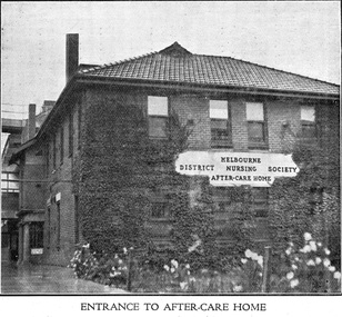
Photograph - Digital image, c.1926
The first After-Care Home in Melbourne was built by the Melbourne District Nursing Society (MDNS) in 1926 for patients of the Society who needed more nursing care than could be given at home but did not need hospitalization. Many patients from Melbourne hospitals who needed further care following discharge from hospital were nursed at the After-Care before going home. The Melbourne District Nursing Society, (MDNS), built the After-Care Home in 1926. The Home was extended and the name changed to Melbourne District Nursing Society and After-Care Hospital in 1934. It was situated at 45 Victoria Parade, Collingwood. Patients of the Society who needed more care than could be given at home, but did not need hospitalization were nursed there, along with many patients from Melbourne hospitals who needed further care before going home. Many children were nursed in the hospital, some long term, during the Polio epidemic and schooling was given to them in the hospital. In September 1930 an Ante-Natal Clinic was established. In October 1934 a Women's Welfare Clinic was opened to educate women on birth control. This was the first of its kind in Melbourne. The MDNS After Care Hospital was under District's banner until 1956. In 1957 the MDNS and the After-Care separated with the Government taking over the running of the After-Care. Melbourne District Nursing Society then became the Melbourne District Nursing Service and in 1966 was given Royal patronage and renamed Royal District Nursing Service (RDNS). Digital image of a front, and part of the left side view, of the Melbourne District Nursing Society After-Care Home and shows the entrance. The white plaque, attached in the centre of the brickwork between the two storeys in the front of the building reads 'Melbourne District Nursing Society After-Care Home' in black capital letters. It is a two story brick building with a tiled pitched roof, and shows two chimneys. There are four long windows running along both storeys of the front and side views. Near the rear left hand side of the building a portico can be seen and behind this part of a brick building with window runs to the left. Greenery is against part of the building and white flowers are seen in the foreground of the photograph. after- care hospital, after-care home, melbourne district nursing society, melbourne district nursing service, mdns, rdns, royal district nursing service -
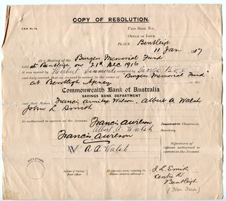 City of Moorabbin Historical Society (Operating the Box Cottage Museum)
Document - Fundraising for the 'Burgess Memorial Fund', c 1916-1917
At a public meeting in January 1917 the residents of the Shire of Moorabbin decided to appeal for funds for the purpose of erecting a memorial to the memory of the late Councillor William George Burgess, who died on 29 November 1916. The committee that was formed to oversee this project described Mr Burgess and his accomplishments: “Mr Burgess served the Shire of Moorabbin in the that capacity faithfully and will for upwards of 35 years. Mr Burgess was a resident of the shire since early boyhood and all through life either initiated or identified himself closely with every movement for the advancement of the district. The acquisition of the Bentleigh Reserve is evidence of his untiring energy and zeal, and it is now proposed to erect a brick pavilion thereon as a monument to the memory of one who had striven to leave the world, and the district in which he resided, a little better than he found it.” The “Burgess Memorial Pavilion” was opened on 13 October 1917. The pavilion was built of brick, with tiled roof, containing two rooms, one 12ft x17ft, the other 12ft x 9ft, a spacious verandah, supported by brick pillars was provided on two sides of the building. Unfortunately the Burgess Pavilion burnt down in June 1928. William Burgess was a Councillor for the Shire of Moorabbin for over 35 years, during which he was the President for five terms. William was a market gardener in Mackay Road, Bentleigh. His family settled in the district in 1855.Two paper documents: One a copy of a resolution re the opening of a bank account ; two a letter from the Southern Cross Press which accompanied a donation for the Burgess Memorial Fundwilliam burgess, the burgess pavilion, bentleigh recreational ground, fundraising, sport, shire of moorabbin -
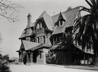 Kew Historical Society Inc
Photograph - Porte-cochere, 'Tara Hall', Studley Park Road, Marc Strizic (attrib), c.1960
'Lost Glories: a memorial to forgotten Australian buildings' was published by David Latta in 1986. It tells the story of a number of significant Australian buildings that had previously been demolished. A chapter in the book was devoted to Goathland, later known as Tara Hall. To supplement the text, he sourced photographs from a range of suppliers, chiefly the Royal Women's Hospital which had once owned Tara Hall, but had sold it in 1960. This is one of the photographs donated to KHS by the author. Porte-cochere, Tara Hall, circa 1957. The main entrance to Tara Hall (previously named Byram, Goathland and Lowan). The entrance, through a porte-cochère, was located on the side of the house facing east. During construction, commentators described the house as being in the ‘Elizabethan style’. The architectural style of the exterior, with its innovatory use of red brick and Italian tiles was more influenced by American models. Edward George Kilburn, of Ellerker & Kilburn, designed Byram for the industrialist George Ramsden in 1888. Typed inscription on reverse: "Goathland, also known as Tara Hall (Royal Women's Hospital, Melbourne)."goathland -- kew (vic), byram -- kew (vic), tara hall - kew (vic), studley park road -
 Kew Historical Society Inc
Photograph - 8 roomed DF Brick Villa, Kew, J E Barnes, c.1920
Subdivision plans are historically important documents used as evidence of the growth of suburbs in Australia. They frequently provide information about when the land was sold on which a built structure was subsequently constructed as well as evidence relating to surveyors and real estate and financial agents. The numerous subdivision plans in the Kew Historical Society's collection represent working documents, ranging from the initial sketches made in planning a subdivision to printed plans on which auctioneers or agents listed the prices for which individual lots were sold. In a number of cases, the reverse of a subdivision plan in the collection includes a photograph of a house that was also for sale by the agent. These photographs provide significant heritage information relating house design and decoration, fencing and household gardens. The photograph is of additional aesthetic significance as it was photographed by J. E. Barnes. Josiah Earl Barnes is a nationally significant photographer. He was also the most important photographer to have worked in Kew. He was active as a photographer in the district from c.1906 until his death in 1921. Best known as 'the Embarkation Photographer' (see the Australian War Memorial collection), J. Earl Barnes was also the official photographer employed by the Borough (and later Town, then City) of Kew. He clearly also completed commercial jobs for local businesses, as is the case in this photograph of a house for a local real estate and financial agent.A photograph, mounted on board of a double fronted Federation-era brick villa in Kew, photographed for a local real estate agent and financier by J. E. Barnes of Kew. On the reverse of the photograph is a subdivision plan for the Normanby Estate, East Kew - 2016.0039.1. As can be seen from the image, there is a large tear on the surface of the photograph.The brown card on which the photograph is mounted includes the following handwritten description, which may aid the identification of the house: "Kew, 3 minutes from tram, 8 roomed DF Brick Villa, tile roof including two attics, sleepout, bathroom, heater, E Light, Entrance Hall, double doors, leadlights, laundry, garden, lawns, land 75 x 170, 1975 pounds". Also photographers inscription on mount, lower left: J. E. Barnes / Photo / Phone 1966 Haw. KEW.j. e. barnes, josiah earl barnes, j. earl banes - photographer, architecture - federation style, houses - kew, real estate photographs -
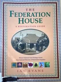 Kew Historical Society Inc
Book, Flannel Flower Press, The Federation House: a restoration guide, 1986, 2004
160 p. : ill. (some col. ) ; 29 cm.non-fictionarchitecture -- domestic -- australia -- conservation and restoration, interior decoration -- australia -
 Bendigo Historical Society Inc.
Photograph - T C WATTS & SON COLLECTION: 17 STERNBERG STREET, BENDIGO, 1928
Edward Claude Binns (1900-1979) was born in Swan Hill to Edward and Helen (nee Dietz) Binns. He was a salesman and lived at 17 Sternberg Street with his wife Eva Mabel (nee Court) who he married in 1926. They had previously lived at 53 Williamson Street, Bendigo.Black and white photograph mounted on rectangular brown board. House, tiled hipped roof. With large portico and brick and concrete pillared verandah. Double front door two double hung windows. Weatherboard and rough cast. Woven wire fence. On back of photo:' T.C. Watts & Son, Ted Binns (name unclear) Sternberg St., October 1928. Dr. Gretton-Watson, tenant at 35/- week, 5 rooms and sleepout. Mrs. C. Morris Owner £2750, gas heater' On front of photo, written in pen ' 17 Sternberg Street'.bendigo, business, t c watts and son, binns -
 Bendigo Historical Society Inc.
Postcard - ROY AND DORIS KELLY COLLECTION: VERCLAU, 1900-1920
Postcard, B&W image of a tiled roof, brick house behind a picket fence and front lawn and flower garden. A woman stands on the front verandah and a man stands to the right of the steps up to the house. Front gate from a footpath at lower right. On the back handwritten in ink ' 1916-1917 Season's Greetings from "Verclau" Also an oval shaped stamp inside reads 'A Aberline 138 Glenferrie Rd Glenferrie' 'Verclau' is the name of the house in Stevenson St, Kew, Melbourne. According to a press death notice a family called GUY was living there in 1917.postcard, photograph, postcard, verclau, house, stevenson st, kew -
 Surrey Hills Historical Society Collection
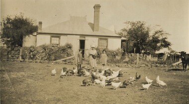
Photograph, Mair family visiting the Jarmans at Derrinallum, c1927 (2), c1927
David Miller (Dave) Mair (1879-1938) married Lily Vipond Deakin (1890-1945) in 1910. They had 5 children: Geoffrey David (1913-1970), Beryl (1916-1976), Gwynneth (1917-1997), Isabel Lillian (1921-1997) and Shirley Inez (1928-1968). Personal communication from Laurie Newton, Beryl's daughter: Dave and Beryl initially lived in East Melbourne after they married. Dave walked across the gardens to work at the MCG. He never drove or owned a car. Geoffrey, Beryl and Gwynneth were born in East Melbourne. They subsequently moved to Louise Avenue, Mont Albert and Isabel may have been born while they were there. Later they purchased 20 Barton Street, Mont Albert. Shirley was born after they moved to Barton Street. Electoral roll details: 1919 1922 24 Louise Avenue, Mont Albert 1924 20 Barton Street, Mont Albert Dave Mair was a very keen sportsman. This is part of a large donation of material from the Deakin, Mair and Young families. The Deakin, Mair and Young families had many connections with Mont Albert and Surrey Hills.A sepia photo of a woman and 2 girls standing behind about 30 fowls. The woman is holding a dish. In the background is an Edwardian (?) timber house with 2 brick chimneys and a corrugated iron roof, the ridge of which has a narrow peak with simple finials and ridge tiles. There is a centrally positioned (?) rear door with windows either side. There is a tank to the left of the house and a veranda to the RHS. The house is enclosed within a post and wire fence with a wire gate in line with the door. The fence appears to be lined with large rocks and behind the fence is garden plants of which cannot be identified. A few cows are to the right off-side.On the rear in black ink: "Feeding the fowls at / Derrinallum / Beryl Mair / 20 Barton Street / Surrey Hills / E10." Writing may be that of Lily Mair. In blue biro: " Gwen Beryl Mrs Jarman / Beauty (Jersey cow)" Thought to be Beryl Mair's handwriting. "KODAK PRINT" in black. beryl mair, gwen mair, farms, derrinallum, mrs jarman -
 Bayside Gallery - Bayside City Council Art & Heritage Collection
Work on paper - watercolour, John C. Paul, St. Andrew's Brighton, 1971
St Andrew’s Anglican Church, located at 228 New St, Brighton, is the oldest continuous Anglican Church in Victoria. Opened on St Andrews day in 1842, it was one of the earliest Christian churches established in the Port Phillip District. A second church building was erected on the site in 1851, followed by a third building and schoolhouse in 1857 which was enlarged in 1886. A fire in 1961 engulfed the building and renowned Australian church architect Louis Williams was appointed to be the architect of the new building. The present church complex is amongst the largest church buildings in Australasia. Using over 500,000 bricks and over 16,000 roof tiles, this space consisted of three areas: the main church building, the Pioneer chapel and the Lady chapel. The large arcaded cloister, seen in this painting, with an internal cloister garden, is extremely rare in any church in Australasia, and links the Pioneer Chapel to the narthex of the new building.John C. Paul, St. Andrew's Brighton 1971, watercolour, 44 x 30.5 cm. Bayside City Council Art and Heritage Collection. Purchased 1974.brighton, john c paul, st andrews, church, anglican, cloister, arcade -
 Kew Historical Society Inc
Plan - Subdivision Plan, Goldthorns Hill Estate, 1925
Pru Sanderson, in her groundbreaking ‘City of Kew Urban Conservation Study : Volume 2 - Development History’ (1988), summarised the periods of urban development and subdivisions of land in Kew. The periods that she identified included 1845-1880, 1880-1893, 1893-1921, 1921-1933, 1933-1943, and Post-War Development. These periods were selected as they represented periods of rapid growth or decline in urban development. An obvious starting point for Sanderson’s groupings involved population growth and the associated economic cycles. These cycles also highlighted urban expansion onto land that was predominantly rural, although in other cases it represented the decline and breakup of large estates. A number of the plans in the Kew Historical Society’s collection can also be found in other collections, such as those of the State Library of Victoria and the Boroondara Library Service. A number are however unique to the collection.The Kew Historical Society collection includes almost 100 subdivision plans pertaining to suburbs of the City of Melbourne. Most of these are of Kew, Kew East or Studley Park, although a smaller number are plans of Camberwell, Deepdene, Balwyn and Hawthorn. It is believed that the majority of the plans were gifted to the Society by persons connected with the real estate firm - J. R. Mathers and McMillan, 136 Cotham Road, Kew. The Plans in the collection are rarely in pristine form, being working plans on which the agent would write notes and record lots sold and the prices of these. The subdivision plans are historically significant examples of the growth of urban Melbourne from the beginning of the 20th Century up until the 1980s. A number of the plans are double-sided and often include a photograph on the reverse. The Goldthorns Hill Estate subdivision was first put up for auction in 1925. The subdivision took its name from the mansion ‘Goldthorns’, shown on the plan between Normanby Road and Lady Loch’s Drive. Contemporary advertisements describe forty-three home sites being fro sale, yet only forty-one appear on this plan. Buyers were lured by the prospect of the proposed extension of the Burke Road tram to High Street. Discerning buyers were advised that only one house could be built per allotment, and that houses needed to be constructed of brick, stone or concrete and have a slate or tiled roof.goldthorns avenue -- kew east (vic.), lady loch drive -- kew east (vic.), argyle road -- kew east (vic.), lady brassey drive -- kew east (vic.), campbell street -- kew east (vic.), goldthorns -- kew (vic.), subdivisions -- kew east (viv.), goldthorns hill estate -
 Kew Historical Society Inc
Photograph - 29 Uvadale Grove, Kew, 1920
The numerous subdivision plans in the Kew Historical Society's collection represent working documents, ranging from the initial sketches made in planning a subdivision to printed plans on which auctioneers or agents listed the prices for which individual lots were sold. In a number of cases, the reverse of a subdivision plan in the collection includes a photograph of a house that was also for sale by the agent. Subdivision plans are historically important documents used as evidence of the growth of suburbs in Australia. They frequently provide information about when the land was sold on which a built structure was subsequently constructed as well as evidence relating to surveyors and real estate and financial agents. These photographs provide significant heritage information relating house design and decoration, fencing and household gardens.When 29 Uvadale Grove, Kew was offered for sale it was described as: ‘Kew. Fine locality, 3 minutes Cotham Road. Splendidly built 6 roomed Brick Villa. Rooms 17 x 14, 16 x 13, &c. Beautifully fitted throughout. Land 70 x 134 to ROW.’ The price was advertised as being £1,400. The house exhibits key features of Federation architecture such as the gabled roof with a facing of half-timber and stucco. The veranda has a curved corrugated iron roof supported by timber pillars and fretwork. The slate roof with terra cotta ridging and finials marks a transition to the more common use of Marseilles tiles in Federation architecture.subdivisions - kew (vic.), 29 uvadale grove - kew (vic.) -
 Kew Historical Society Inc
Photograph - Brick and Stucco Bungalow, J E Barnes, c.1920
The Kew Historical Society's map collection includes a substantial number of real estate subdivision plans, mainly of Kew but also of surrounding suburbs in Melbourne. Most of the subdivision plans date from the 1920s and 1930s when the districts old homes and local farmland were being split up to accommodate residential growth in the postwar period. These early plans were assembled by a local firm, Jas R Mather & McMillan, which had an office in Cotham Road. Many of the plans, and sometimes photos, were annotated by the agents.Subdivision plans are historically important documents used as evidence for the growth of suburbs in Australia. They frequently provide information about when the land was sold as well as evidence relating to surveyors and real estate and financial agents. The numerous subdivision plans in the Kew Historical Society's collection represent working documents, ranging from the initial sketches made in planning a subdivision to printed plans on which auctioneers or agents listed the prices for which individual lots were sold. In a number of cases, the reverse of a subdivision plan in the collection includes a photograph of a house that was also for sale by the agent. These photographs provide significant heritage information relating house design and decoration, fencing and household gardens.The photograph may also be aesthetically significant depending o the importance of the photographic atelier.Real estate photograph for a local agent by the Kew photographer, Josiah Earl Barnes. The photo is of a weatherboard or brick rendered bungalow with a twisted wire fence. Given Barnes' status a a Kew photographer, the house is probably locate din Kew or East Kew. Unfortunately the handwritten information on the mount bordering the photo is damaged and cannot be read. The bungalow has a gabled, tiled roof with terra cotta finials at the front of both gables. The house has a central doorway, framed by a pseudo portico supported by four wooden columns. On each side of the doorway, at the front, there are paired sash windows, which, like the half-timbered gable, are picked out in a darker colour.Handwritten, mostly illegible description by selling agent on mount surround: " .... in Diningroom, Drawing Rooms, ... Photographers details printed on mount: "J. E. Barnes / Photo / Phone 1966 Haw KEW"houses - kew, bungalows - kew, real estate photographs, j.e. barnes -- photographer -
 Kew Historical Society Inc
Plan - Subdivision Plan, Violet Farm Estate, 1927
Pru Sanderson, in her groundbreaking ‘City of Kew Urban Conservation Study : Volume 2 - Development History’ (1988), summarised the periods of urban development and subdivisions of land in Kew. The periods that she identified included 1845-1880, 1880-1893, 1893-1921, 1921-1933, 1933-1943, and Post-War Development. These periods were selected as they represented periods of rapid growth or decline in urban development. An obvious starting point for Sanderson’s groupings involved population growth and the associated economic cycles. These cycles also highlighted urban expansion onto land that was predominantly rural, although in other cases it represented the decline and breakup of large estates. A number of the plans in the Kew Historical Society’s collection can also be found in other collections, such as those of the State Library of Victoria and the Boroondara Library Service. A number are however unique to the collection.The Kew Historical Society collection includes almost 100 subdivision plans pertaining to suburbs of the City of Melbourne. Most of these are of Kew, Kew East or Studley Park, although a smaller number are plans of Camberwell, Deepdene, Balwyn and Hawthorn. It is believed that the majority of the plans were gifted to the Society by persons connected with the real estate firm - J. R. Mathers and McMillan, 136 Cotham Road, Kew. The Plans in the collection are rarely in pristine form, being working plans on which the agent would write notes and record lots sold and the prices of these.The subdivision plans are historically significant examples of the growth of urban Melbourne from the beginning of the 20th Century up until the 1980s. A number of the plans are double-sided and often include a photograph on the reverse. A subdivision plan for nineteen ‘bonny, airy building blocks’ on either side of Violet Grove, Kew East. Violet Grove runs between High Street and Harp Road. Like many other subdivisions in Kew and East Kew, older houses (Lots 1 and 13) were often included in the subdivision. Such houses were in some instances the original properties that were subdivided, or in the case of the Violet Grove subdivision, new houses such as the weatherboard villa on lot 13. This villa is advertised as having a tiled roof, 5 rooms, panelled hall, double doors (Rooms 14 x 12 ft. 6 in. (2) 14 x 12, 12 x 11, 13 x 11). A bricked front verandah, a tiled stove recess and existing sewerage connection added to its saleable potential. Water, electric light and power, and gas were all offered as part of the deal. Violet Grove now has about 35 houses, which indicates that the 19 lots of the subdivision were to be further subdivided by purchasers. [A similar plan is in the Batten & Percy Collection of the State Library of Victoria.]subdivision plans - east kew, violet farm estate, violet grove -- kew (vic.), boorool road -- kew (vic.), harp road -- kew east (vic.) -
 Victoria Police Museum
Police Stations (Armadale)
Armadale is an inner suburb of Melbourne, Victoria, Australia, 7 km south-east of Melbourne's Central Business District, located within the City of Stonnington local government area. Armadale Police Station opened, in Melbourne Police District, on 11 May 1885. Its original location is unknown, but in 1890 it is listed in the Sands & McDougall directory as at 295 Hight Street. From 1985-1920 it was located at 20/22 Auburn Grove, 1925-1930 at 769 High Street and 1935-1946 at 3 Cheel Street. The station closed on 28 January 1946. The sub-division east of Orrong Rd was incorporated into Malvern Sub-district and west of Orrong Road into Prahran Sub-district. In a special 1930 issue of the Victoria Police Gazette the Armadale Police Station was described as a seven-roomed brick dwelling with a tiled roof on land measuring 127' x 104' x 98'. There was also a bathroom and W.C., a wash-house, office, and a lock-up (one cell). This is probably a description of the Cheel Street police station. It was staffed by one senior constable and three foot constables.12 photographs comprising 8 coloured images and 4 black and white images 1 sketch plan of Old Armadale Police Stationpolice stations; armadale police station -
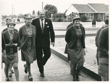 Royal District Nursing Service (now known as Bolton Clarke)
Photograph - Photograph, black and white, Barry Sutton, 11.05.1971
Mr. John Rossiter is the Minister of Health of Victoria. The RDNS Sisters are wearing their uniforms of grey dresses, red cardigans and grey peaked hats. The RDNS badge on their hats are made of metal with a royal blue circle containing the letters "Royal District Nursing Service". The inner section is divided in three parts; the upper and lower sections are silver and the centre section has the capital letters RDNS written in royal blue across it.Black and white photograph showing seven Royal District Nursing (RDNS) Sisters, four only partially seen, walking along a footpath with Mr. John Rossiter. Mr. Rossiter, who is in the centre of the photograph and group, has balding dark hair and is wearing a white shirt, striped tie, and a dark striped suit with a white flower in the button hole on his left lapel; a corner of a white handkerchief is seen in the left pocket of his jacket. The full view of three RDNS Sisters can be seen wearing their uniforms of a grey frock and dark cardigan and grey peaked hats with a round badge in the centre. In the background are some cars on the road, lamp posts and some trees. A white fence and a brick house with a tiled pitched roof is seen in the right hand side background.Photographers stamp. Quote No. KG 48royal district nursing service, rdns, rdns uniform, mr john rossiter -
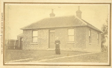 Bacchus Marsh & District Historical Society
Photograph, James Reid House Bacchus Marsh 1883
James Reid was born in Scotland near Glasgow and came to Victoria as a young man in 1854. Shortly after arriving he came to Bacchus Marsh where he lived until his death in 1902 at the age of 74 years. For most of these years he conducted a wheelwrights and coach builders business in Bacchus Marsh. In the nineteenth and early twentieth centuries, wheelwrights and blacksmiths played an essential role in the functioning of the whole community. Before the industrialisation of manufacturing, wheels and other components of vehicles for transport, all metal objects, including farm implements, building requirements and domestic utensils were made by hand. As mechanisation of industry increased, the smith commonly performed the role of farrier in the times when horse power was pivotal to all aspects of society. Small sepia unframed photograph on card with gold border framing photograph. Housed in the album, 'Photographs of Bacchus Marsh and District in 1883 by Stevenson and McNicoll' The photo shows a plain brick house with a central front door with a window on either side. There are a further two windows along the side of the house. On the left-hand side of the building there is a smaller room with its own entry door. The main roof is tiled with shingles or slate and features two substantial chimneys. At the front of the house stands a young woman with her hands clasped. A horse can be seen at the rear of the house. From the photo of the James Reid Wheelwright and Blacksmith Shop, Victorian Collections No.VC 618, we know that this house stood to the rear of the workshop. The wheel tracks which can be seen lead out to Main Street. On the front: Stevenson & McNicoll. Photo. 108 Elizabeth St. Melbourne. COPIES CAN BE OBTAINED AT ANY TIME. On the back: LIGHT & TRUTH inscribed on a banner surmounted by a representation of the rising sun. Copies of this Portrait can be had at any time by sending the Name and Post Office Money Order or Stamps for the amount of order to STEVENSON & McNICOLL LATE BENSON & STEVENSON, Photographers. 108 Elizabeth Street, MELBOURNE houses bacchus marsh, stevenson and mcnicoll 1883 photographs of bacchus marsh and district, james reid 1828?-1902, wheelrights bacchus marsh -
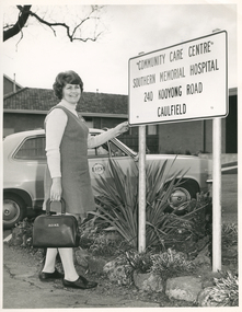 Royal District Nursing Service (now known as Bolton Clarke)
Photograph - Photograph, black and white, Barry Sutton, c.1978
Sister Watt is an RDNS Liaison Sister and has arrived at the Community Care Centre at Southern Memorial Hospital where she works. She attends discharge meetings and visits patients who will need nursing care from RDNS when they go home. Sr. Watt is wearing the RDNS winter uniform of a blue/grey skivvie under a blue/grey V neck tunic style dress made of herringbone winter material. The RDNS logo on the car is a royal blue edged circle with the words "Royal District Nursing Service" written in white capital letters around it. The centre of the circle is divided in three with the upper and lower sections white, and the centre section royal blue with white capital letters "RDNS".Liaison had occurred between Doctors and the Trained nurses (Nurses) of the Melbourne District Nursing Society (MDNS), from its inception in 1885. This increased when Midwifery was introduced in August 1893 with close liaising with the Women’s Hospital. As District nursing grew it was recognized that closer liaising between many Public Hospitals would be beneficial, for not only the MDNS, later called Royal District Nursing Service (RDNS), Trained nurses (Sisters), but also for the patients and the hospitals. In August 1964 a Liaison Officer commenced at the Alfred Hospital. This soon increased to Liaison Officers working full time at several Public Hospitals. They facilitated the smooth transition from hospital to home for many patients who required ongoing nursing care. Liaison Sisters regularly attended discharge planning meetings, interviewed prospective patients, co-ordinated discharge and booked the first visit by the visiting RDNS Sister. At the time of a patient’s discharge, the Liaison Sister forwarded information on their diagnosis and instructions regarding the care required at home to the appropriate RDNS Centre, and in turn the attending District Sister wrote a report of progress and any queries to the Hospital Doctor, via the Liaison Sister, at the time the patient was attending outpatients. Any new instructions were then sent back to the District Sister. Liaising also occurred between District Sisters and Doctors when patients were referred by General Practitioners and did not attend a hospital.On the left of this black and white photograph is Royal District Nursing Service (RDNS) Sister (Sr.) Helen Watt, who has short dark wavy hair; is smiling and is looking towards the camera. She is standing with her left hand on the bottom edge of a large white sign with a black border and capital letters. It reads, in four lines, "Community Care Centre/, Southern Memorial Hospital/, 240 Kooyong Road/, Caulfield/." Sr. Watt is wearing a light grey skivvie and a darker grey V neck tunic style frock. Her right hand is holding the solid horseshoe style handle on top of a black leather bag with the light colored letters "RDNS" in the upper centre. The sign is held up with white round poles either side. These are placed in a garden bed with low foliage and a rock border. Directly behind Sr. Watt is a grey Torana car with the RDNS logo on the upper section of the door. In the left background, behind the car, is a wooden fence and behind that a brick building with a tiled roof and a large window. In the right background, behind the sign, Is part of a brick building with part of a doorway. It has a flat roof.Barry Sutton LO 28royal district nursing service, rdns, rdns liaison, rdns uniform, sister helen watt -
 Eltham District Historical Society Inc
Photograph - Digital Photograph, Marguerite Marshall, Former home of Alistair and Margot Knox, King Street, Eltham, 16 January 2006
Situated in King Street, Eltham, Alistair Knox built his home and office in 1962-1963 with mud-bricks made from the local soil and recycled materials blending the house with bush around it. Knox popularised the Eltham earth building movement, begun by Montsalvat founder, Justus Jorgensen. Alistair Knox (1912-1986) was also an Eltham Shire Councillor 1971-1975 and Shire President in 1975. Knox established the inaugural Eltham Community Festival in 1975. Covered under Heritage Overlay, Nillumbik Planning Scheme. Published: Nillumbik Now and Then / Marguerite Marshall 2008; photographs Alan King with Marguerite Marshall.; p145 Lack of money was a strong incentive for Alistair Knox to do what he did best when he built his house and office at King Street, Eltham in 1962-63. He used mud-bricks from local soil and recycled materials, characteristically blending the house with the bush around it. The result was a work of art. Knox popularised the Eltham earth building movement,1 begun by Montsalvat founder Justus Jörgensen. He was also an Eltham Shire Councillor from 1971 to 1975 and Shire President in 1975. For Knox mud-brick building was not just a building style, but a spiritual experience and a way of relating with nature. At 40 he rediscovered God and his building reflected his theological, political, philosophical and particularly environmental world view, which was far ahead of its time.2 He also contributed to building development in his use of concrete slab foundations when stumps and bearers were the norm. Knox was introduced to mud-brick construction in 1940 by Jörgensen, then shortly after, Knox joined the Navy. In 1946 Knox studied Building Practice and Theory at Melbourne Technical College (now RMIT University). There he befriended fellow student and artist Matcham Skipper who belonged to what was then called the Jörgensen Artists’ Colony. Knox decided to build an earth building in Eltham, partly because the post-war huge building demands resulted in expensive and scarce building materials. He asked artist Sonia Skipper for help who, with Matcham, had constructed mud-brick buildings at the Artists’ Colony. The simple rectangular low-lying house at King Street is framed by native plants and a 3.6 metres wide pergola surrounds the building. Wedded to the landscape, a door in every room at the perimeter, opens outside. The property also includes a forge, a small hut built by son Macgregor at 15, and a mud-brick tower for chickens. Building materials were foraged from a wide variety of sources. Some of the joinery material came from old whisky vats. When the Oregon of the highest quality ‘was put through the wood-working machines, it gave off a deep smell of whisky that made the whole atmosphere exotic and heady’.3 Amateur builders, including schoolboys from Knox’s Presbyterian Church, made some of the mud-bricks. But the building was finished with the professional help of Yorkshire builder, Eric Hirst. Inside, the light is subdued with the mud-brick, beamed timber ceilings and floors of slate, timber or orange-brown tiles. Skylights, with rich blue and red leadlighting, illuminate one entrance area and this feature is repeated as edging on the door. The centre of the house is like a covered courtyard, with rooms built around it. The central room, 11 metres x 7 metres, was built in the same proportions as Knox’s mud-bricks. Clerestory windows on four sides infuse the room with a soft light. A huge brick fireplace extends beyond one corner and opposite is a small one where timber can only be placed vertically. The slate for the floor was discarded from the Malthouse Brewery now used as a theatre in Southbank. In the middle is a large refectory table and benches that seat 18. Like much of the house, it is rugged, yet beautiful. Made of Western Australian Jarrah by Macgregor with a chain saw and an adze, it retains knot and nail holes. Each wall has an opening, 2.4 metres at the ends and 3.6 metres at the sides. Only one has doors and these concertina doors are made of the backs of old church pews. The main bedroom has an ensuite with a marble hand basin discarded from the Victorian Parliament building; and a dressing room, where two wardrobes of polished timber recovered from a tip are attached to the walls. Separate from the house is the strikingly original circular-shaped office made of bluestone sourced from the original Army campsite at Broadmeadows.This collection of almost 130 photos about places and people within the Shire of Nillumbik, an urban and rural municipality in Melbourne's north, contributes to an understanding of the history of the Shire. Published in 2008 immediately prior to the Black Saturday bushfires of February 7, 2009, it documents sites that were impacted, and in some cases destroyed by the fires. It includes photographs taken especially for the publication, creating a unique time capsule representing the Shire in the early 21st century. It remains the most recent comprehenesive publication devoted to the Shire's history connecting local residents to the past. nillumbik now and then (marshall-king) collection, alistair and margot knox house, alistair knox design, mudbrick construction, eltham, king street -
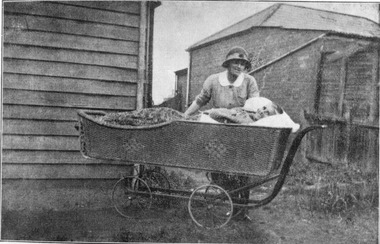 Royal District Nursing Service (now known as Bolton Clarke)
Photograph - Digital image, c.1920
This digital image is taken at the home of a Melbourne District Nursing Society (MDNS) patient, and depicts a MDNS Sister attending to a lady who is lying in a wicker bed pram in the rear garden of her home. The wicker bed pram enabled the lady to enjoy fresh air and to be moved about easily. The image shows the MDNS uniform of a grey cotton frock with white collar, and a grey brimmed hat with a red Maltese cross in the centre of the hatband. In 1885, 50 years after Melbourne was founded, it was recognized that nursing care was needed for the sick poor in inner Melbourne. The Melbourne District Nursing Society (MDNS) was founded in February 1885 with one Trained nurse, known as 'Nurse' in those days, and a second employed six months later,. The two Nurses worked in the now CBD, ie from Spencer Street to Spring Street and from Victoria Parade to Flinders Street. At that time they walked the streets and lane ways amid the slums of inner Melbourne carrying their nursing bags containing lotion, ointments, powders, liniment, bandages, dressings, a case of spirits, and the Nurse's own clean apron, soap and small towel. They supplied equipment on loan, such as earthenware hot water bottles, splints, urinals, bed pans, bed cradles, feeding mugs, and air-cushions as well as providing blankets and clean bed linen, and nightdresses as necessary. From its inception the Society was at the forefront of health care and liaised with Doctors. They provided high quality nursing care to a range of people, often in destitute situations, some lying on rags on the floor as they had no bed, others with just a bed and maybe a thin blanket, a chair and nothing else. Their ages ranged from babes, children, adults to the elderly. The Nurses gave medications as ordered, dressed wounds e.g. to the injured, and surgical cases, and to those with leg ulcers; attended to patients with ‘surgical ailments’ such as ‘hip disease’; gave care to those with acute illnesses such as bronchitis, pleurisy, pneumonia, measles, and scarlet fever, as well as those with chronic illnesses such as consumption (tuberculosis), heart disease, arthritis, cancer, debility, neuritis and paralysis. This image shows a Melbourne District Nursing Society (MDNS) Trained nurse (Sister) wearing a grey uniform with white collar, and a grey brimmed hat, which has a hatband with Maltese cross applied, standing behind and attending an elderly lady patient laying in a wicker bed pram outside her home. The Sister has her right hand resting on the pram and is looking down at the lady, and the lady, who has short grey hair, is smiling and looking toward the camera. Her body is covered with a floral cover. To the left, part of the horizontal weatherboards of a wooden house can be seen, and to the right and rear, a brick, tiled hip roof, building can be seen. The wicker bed pram has four spoked wheels and a metal frame that bends up to form a handle on its right hand side.melbourne district nursing society, mdns, mdns nurses, mdns patient care, mdns uniforms, rdns, royal district nursing service -
 Eltham District Historical Society Inc
Photograph, Fay Bridge, Former Glynn's Dairy Farm, Glynns Road, North Warrandyte, 31 August 2018
Glynn’s farm Originally Section 7, Parish of Nillumbik marked Aborigine Reserve in 1866 Crown Allotment 8, Section 7, Parish of Nillumbik, County of Evelyn, Certificate of Title Volume 4095, Folio 818.835, approx. 93 acres purchased by Joseph Panton in 1881 for £1/acre and known as Panton’s Point. By 1924 owned by S.S. Sergeant and called Riverswood. Sergeant commissioned Edna Walling to design the garden. In September 1929 the property was sold at auction by Mortgagee’s sale. Described as well built, brick, tile roof, Attic Villa containing downstairs 7 good rooms, bath, scullery, inside lavatory, etc. Upstairs 2 bedrooms and sleep out. Outbuildings compromising of brick and weatherboard wash house, stables, workshop, feed room, cow bails, large G.I. Hay shed, etc In January 1931 Riverswood property was proclaimed a sanctuary for native game for the entire year. A private swing bridge crossed the river at Pound Bend was known as Pearson’s bridge after C.W.K. Pearson who bought Riverswood in the early 1930s. The bridge was swept away in the December 1934 floods. Riverswood was sold by C.W.K. Pearson at auction on 25 November 1936. Described as a beautiful farm home of 93 acres and over one mile of River Yarra frontage, modern brick residence, lovely garden, rich river flat pastures, model poultry farm. The fine brick home was destroyed on Black Friday (13 Jan.) 1939. It was still a ruin when the Evelyn Evans purchased Waikowhane above Riverswood in 1940. The Glynn family purchased the Riverswood property in 1941 from Robert and Emily Hannon. Their son Kenneth Patrick Glynn inherited the property and he set about clearing the land during WW2 selling wood. Prior to marriage, Kenneth was living alone on the farm in a house he had built from whatever was available. He used the bluestone foundations from the original fine brick home. He met and married Honora Elizabeth Drew in early 1945 and their daughter Anna grew up on the farm. It was compulsorily acquired by the Board of Works in 1976 who then rented the house out in the 1980s. The property was transferred to Melbourne Parks and Waterways in 1996. Waikowhane was a pretty timber house built on top of the hill on 50 acres above Riverswood by retired nurse Jessie MacBeth. (This would be at the intersection of Glynns Road and Overbank Road where the big water tank is now situated on what was once James Orford’s property.) It was also destroyed Black Friday and she rebuilt it from the plans living in a caravan on site supervising the build. It was almost complete when she died May 1939. The property was bought by Evelyn Evans (a city girl) and her estranged husband in 1940. She had two sons, one only 9 months old at the time. It was a timber house with no power or water connected. The Ewen Cameron family bought Waikowhane in 1957. They had to evacuate when the 1961 bushfires swept through. The house was saved by Matcham Skipper. It was demolished by Melbourne Water in the 1990s when they acquired it.fay bridge collection, 2018-08-31, glynn's, glynn's dairy farm, glynns road, north warrandyte, parks victoria, ruins, riverswood, kenneth patrick glynn -
 Ringwood and District Historical Society
Map, The East Estate, Township of Ringwood, Victoria - 1927
Photocopied page - partial Parish map of Ringwood labeled The East Estate, showing street names and properties marked with names of individual owners or businesses.Page titled The East Estate by 1927 Part of Township of Ringwood, Parish of Ringwood, County of Mornington, Scale: Four Chains to One Inch. L.F. East blocks are marked by red outline. J. Blood blocks are marked by blue outline. Other names include B.C. Hutchinson & Co., The Victorian Brick & Ornamental Tile Coy., Ltd., The Ringwood Brickmaking Coy., Ltd., R. Davidson, J. Williamson, W.E. Bower, H. Jennings, G.J. Sims, J. Smallman, J. Horne, J. Lindsay, J. Kay, H. Unverhan, B.C. Hutchinson, M.A. Williamson, J.S. Woodworth, J. Price, C. Medew, S.W. Burchett, B.J. Hosking, D.J. Rogers, C. Wheeler, H. Frost, G.G. Miller, L. Winchcombe. Streets include Dublin Road, Illoura Road, Alexandra Road, and Bedford Road. -
 Victoria Police Museum
Police Stations (Ascot Vale)
Ascot Vale is an inner suburb 6 km north-west of Melbourne, Victoria, Australia in the local government area of the City of Moonee Valley. Ascot Vale police station was opened on 31 October 1887 in the Melbourne Police District. From 1900-1905 it was located at 54 Parade, Ascot Vale; from 1910-1925 at 71 St Leonards Road; from 1930-1953 at 37 St Leonards Road. In 1953 it was relocated to government owned premises at 111 Union Road until the police station closed on 1st May 1970 and the Sub-district was divided between Flemington and Moonee Ponds police stations. The former police station was used by the Crime Car Squad until about 1987 when the premises were damaged by fire. The police station at 37 St Leonards Road was described as a six-roomed brick dwelling with slate and iron roof on land measuring 150' x 50'. There was also a bathroom and W.C., wash-house, office and lock-up with one cell. It was staffed by one second-class sergeant and four foot constables. The purpose-built police station at 111 Union Road included a four-roomed residence with the exterior clad in rough cast Conite and a tile roof. There was also a kitchen, bathroom, laundry and separate garage. 4 black and white photospolice stations; ascot vale police station -
 Bacchus Marsh & District Historical Society
Photograph, House of Christopher Crisp Bacchus Marsh 1883
The former Christopher Crisp residence was constructed in 1868 by William Watson, one of the members of the Bacchus Marsh Express printing company which took over the management of The Express after the first edition, 7 July 1866, was published by its founder, George Lane, a book binder. This syndicate failed after three months and the ownership was then taken over by Christopher Crisp, a compositor working for the company. Crisp remained the editor from 1866 to his death in 1915, when he was succeeded by his son, also called Christopher Crisp, and later by his grandson. Under the Crisp family leadership, The Express widened its readership and was subscribed to by influential men and public servants in Melbourne. (Heritage Victoria Council. Places. Entry no. 45.)Small sepia unframed photograph on card with gold border framing photograph. Housed in the album, 'Photographs of Bacchus Marsh and District in 1883 by Stevenson and McNicoll'. The photograph is of a single-storey cottage of rendered brick and sandstone with a shingled roof of slate tiles and ornate concave verandah. A chimney stands at either end of the house. A carved barge board decorates the northern end of the hip roof. A skillion with windows and a chimney adjoins the rear of the cottage. The front facade is symmetrical with two sash windows placed either side of the central door. A wire fence runs along the front of the cottage. Standing at the gate is a formally dressed gentleman wearing a top hat. A young child is standing on the road. This child is possibly Christopher Crisp, Jnr., who later took over the role of editor of the Bacchus Marsh Express in 1915 on the death of his father. At the time of this photo, he would have been 4 years old. On the front: Stevenson & McNicoll. Photo. 108 Elizabeth St. Melbourne. COPIES CAN BE OBTAINED AT ANY TIME. On the back: LIGHT & TRUTH inscribed on a banner surmounted by a representation of the rising sun. Copies of this Portrait can be had at any time by sending the Name and Post Office Money Order or Stamps for the amount of order to STEVENSON & McNICOLL LATE BENSON & STEVENSON, Photographers. 108 Elizabeth Street, MELBOURNE. stevenson and mcnicoll 1883 photographs of bacchus marsh and district, houses bacchus marsh, christopher crisp 1844-1915