Showing 379 items matching "caulfield city council"
-
 Glen Eira Historical Society
Album - Album page, Glenferrie Street, 4, Circa 1972
... ) and Caulfield City Council to identify historic buildings within...) and Caulfield City Council to identify historic buildings within ...This photograph is part of the Caulfield Historical Album 1972. This album was created in approximately 1972 as part of a project by the Caulfield Historical Society to assist in identifying buildings worthy of preservation. The album is related to a Survey the Caulfield Historical Society developed in collaboration with the National Trust of Australia (Victoria) and Caulfield City Council to identify historic buildings within the City of Caulfield that warranted the protection of a National Trust Classification. Principal photographer thought to be Trevor Hart, member of Caulfield Historical Society. Most photographs were taken between 1966-1972 with a small number of photographs being older and from unknown sources. All photographs are black and white except where stated, with 386 photographs over 198 pages. From Glen Eira Heritage Management Plan 1996 by Andrew Ward: In 1905, most of portion 27 was vacant land, however Glenferrie Street had been formed and the land subsequently subdivided. In 1906, Robert Joseph Haddon, architect and painter, designed and built for his private residence, a brick house on the west side. Haddon named the house "Anselm". Also built on the property were a garage and fibro cement studio. "Anselm" is architecturally important at the State level as a substantially intact, highly personalised and boldly expressed house expressive the Arts and Crafts movement and incorporating Art Nouveaux enrichment in a variety of forms, the use of ornamental terra cotta tiles to the comer tower being of special note. Its importance at the State level is strengthened by its place as the home of the noted architect and Melboume's most influential exponent (Freeland, J.M., Architecture in Australia, p. 213) of the Art Nouveaux movement. Victorian Heritage Register https://vhd.heritagecouncil.vic.gov.au/places/4442 What is significant? Anselm was designed by noted English born architect Robert Joseph Haddon(1866-1929) as his own house and constructed in 1906. A single storey Arts and Crafts influenced red brick house with attic, Anselm has a pyramidal slate roof with prominent chimney stacks. There is a octagonal corner tower with saucer shaped domed roof surmounted by a weather vane, and the tower has decorative terracotta panels immediately below the eaves line. The front door opens immediately into a large living or common room, screened from view by a timber and bottle glass screen. The large room was designed to function as a drawing and dining room. The house is rich with hand crafted details including door and window furniture, wrought iron gutter brackets, fireplaces (one with built in wood box), and fire tools. The interior decoration includes hand painted frieze of Port Phillip in the study, and a hand painted frieze of turbulent sea with sailing boats in the tiled bathroom. There is a small hand painted tile at the base of the tower which states ?This building was erected AD1906 from designs by Robt J Haddon FRIBA,Lond FRIVA Melb Architect?. He also designed an attic addition which was constructed in 1927. Anselm is substantially intact although the double casement window immediately to the south of the front door was originally circular....Page 61 of Photograph Album with one exterior photograph (portrait) of Anselm.Hand written: 61 [bottom left] trevor hart, anselm, art nouveaux, arts and crafts, tower, bay window, glenferrie street, robert joseph haddon, 1900's, terra cotta tiles, double storey, caulfield north, corner tower, brick house, attics -
 Glen Eira Historical Society
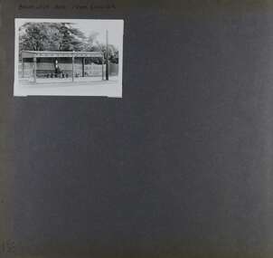
Album - Album page, Balaclava Road Tram Shelter, Circa 1972
... ) and Caulfield City Council to identify historic buildings within...) and Caulfield City Council to identify historic buildings within ...This photograph is part of the Caulfield Historical Album 1972. This album was created in approximately 1972 as part of a project by the Caulfield Historical Society to assist in identifying buildings worthy of preservation. The album is related to a Survey the Caulfield Historical Society developed in collaboration with the National Trust of Australia (Victoria) and Caulfield City Council to identify historic buildings within the City of Caulfield that warranted the protection of a National Trust Classification. Principal photographer thought to be Trevor Hart, member of Caulfield Historical Society. Most photographs were taken between 1966-1972 with a small number of photographs being older and from unknown sources. All photographs are black and white except where stated, with 386 photographs over 198 pages. From Victorian Heritage Database citation H0174 TRAM VERANDAH SHELTER CORNER BALACLAVA AND ORRONG ROADS CAULFIELD NORTH - Vic Heritage Register https://vhd.heritagecouncil.vic.gov.au/places/2721 (as at 28/10/2020) The waiting shelter at the corner of Balaclava Road and Orrong Road, Caulfield was constructed in 1916/17 for the Prahran and Malvern Tramways Trust and is one of only three remaining tram shelters in Melbourne designed in the form of a verandah. The shelter has a corrugated iron roof fixed to an angle iron roof frame. The roof, which extends in the form of a skillion over the pavement, is supported on three squared, chamfered timber posts at the rear and three cast iron reeded columns with round bases and Corinthian capitals at the front. (The columns are hollow and function as downpipes, with rainwater discharging from the verandah roof, through the columns and under the ground). The shelter has a rinceau pattern frieze along the road frontage with centrally placed shield motif (which does not contain a coat of arms). The side and rear panels are lined with ripple iron and the upper panel at the rear is lattice work. The shelter has two timber slatted bench seats.From Victorian Heritage Database citation for H0174 TRAM VERANDAH SHELTER CORNER BALACLAVA AND ORRONG ROADS CAULFIELD NORTH - Vic Heritage Register https://vhd.heritagecouncil.vic.gov.au/places/2721 (as at 28/10/2020) How is it significant? The waiting shelter at the corner of Balaclava Road and Orrong Road, Caulfield is of historical and architectural significance to the State of Victoria. Why is it significant? The waiting shelter is of historical significance for its association with the development of the suburban (electric) tram network which assisted the expansion of Melbourne as a suburban metropolis. It is also of historical significance for its connection with the Prahran & Malvern Tramways Trust. The Prahran & Malvern Tramways Trust (1907-1920) was the first municipal electric tramway in Melbourne, becoming the largest and most successful of all the municipal tramway trusts. Its services played a key role in facilitating suburban expansion and the development of the southern and eastern suburbs. The growth of tramways was one of the greatest municipal developments in Victoria during the first decade of the twentieth century. The waiting shelter is an important remnant of this period of Melbourne's transport history and a tangible reminder of the Prahran & Malvern Tramways Trust. The shelter indicates the extent of the Prahran & Malvern tram network. The waiting shelter at corner of Balaclava Road and Orrong Road, Caulfield is one of only three remaining tram shelters in Melbourne designed in the form of a verandah. The waiting shelter is of architectural significance for the distinctive design and construction which is unique to the Prahran & Malvern Tramway Trust tram network. The shelter was designed by notable Melbourne architect Leonard J. Flannagan (1864-1946). Flannagan was responsible for a number of buildings for the Prahran and Malvern Tramways Trust including the early waiting shelter at the junction of Dandenong Road and Hawthorn Road, Caulfield, and sections of the tram depot at Malvern, and also designed a depot for the Hawthorn Tramways Trust. The waiting shelter, a conservative design influenced by Victorian architecture, is based on the Melbourne City Council late 19th century standard cast iron verandah. It is of significance as an intact example of the cast iron type shelter and for its detail, including Corinthian columns and a 'rinceau' pattern cast-iron frieze. The shelter is largely in keeping with the original design and retains its integrity. The cast iron waiting shelter is also of significance as an unusual example of early twentieth century street architecture. Page 155 of Photograph Album with one landscape photograph of a tram shelter on Balaclava Road.Handwritten: BALACLAVA ROAD TRAM SHELTER [top] / 155 [bottom left]trevor hart, verandah, garden, grimwade house, grimwade, orrong road, balaclava road, melbourne grammar, melbourne grammar junior school, mgs, m.g.s, school, tram shelter, waiting shelter, prahran & malvern tramway trust, leonard j. flannagan, cast iron verandah, cast iron type shelter, corinthian columns, 'rinceau' pattern cast-iron frieze, rinceau, cast iron frieze, victorian style, caulfield north, leonard flanagan, cast iron work, prahran and malvern tramways trust, trams -
 Glen Eira Historical Society
Album - Album page, Glen Huntly Road, Circa 1972
... ) and Caulfield City Council to identify historic buildings within...) and Caulfield City Council to identify historic buildings within ...This photograph is part of the Caulfield Historical Album 1972. This album was created in approximately 1972 as part of a project by the Caulfield Historical Society to assist in identifying buildings worthy of preservation. The album is related to a Survey the Caulfield Historical Society developed in collaboration with the National Trust of Australia (Victoria) and Caulfield City Council to identify historic buildings within the City of Caulfield that warranted the protection of a National Trust Classification. Principal photographer thought to be Trevor Hart, member of Caulfield Historical Society. Most photographs were taken between 1966-1972 with a small number of photographs being older and from unknown sources. All photographs are black and white except where stated, with 386 photographs over 198 pages. From: Glen Eira Heritage Management Plan (1996) by Andrew Ward and Associates Moore's Buildings", were built in 1891 and comprising 5 shops. In 1888, Hugh Moore, a gentleman, subdivided his land in Glen Huntly Road, north side between Selwyn Street and St Georges Road into 27 lots, with a right of way separating them from his property "Glenmoore". The subdivision was known as the "Glenmoore Estate". Purchases of land included local builders Corkill, French and Pugh. Moore retained five lots and W.W. Jamieson bought lots 11 to 14. "Moore' s Buildings are locally important for their association with the early Elsternwick land owner, Hugh Moore, whose home, "Glenmoore", at 1 St.Georges Road (qv) survives. They recall Elsternwick's role in the Land Boom and survive as a most prominent row in the Glen Huntly Road shops, enhanced by the survival of the unpainted stuccoed surfaces to nos. 307-311. 287-289 Glen Huntly Road: contributory to HO72, Elsternwick Estate and Environs, City of Glen Eira.Page 63 of Photograph Album with one landscape photograph of retail shops (Moore's Buildings).Hand written: 287-289 Glen Huntly Road [under photo] / 63 [bottom left] trevor hart, shop, grocer, stuccoed, terrace, victorian terrace, protruding parapet, ornate render, hugh moore, 1890's, moore's buildings, glenmoore, glenmoore estate, shopping centres, milk bars, cars, victorian style, glen huntly road, glenhuntly road, elsternwick -
 Glen Eira Historical Society
Album - Album page, London Tavern, Hawthorn Road, Circa 1972
... ) and Caulfield City Council to identify historic buildings within...) and Caulfield City Council to identify historic buildings within ...This photograph is part of the Caulfield Historical Album 1972. This album was created in approximately 1972 as part of a project by the Caulfield Historical Society to assist in identifying buildings worthy of preservation. The album is related to a Survey the Caulfield Historical Society developed in collaboration with the National Trust of Australia (Victoria) and Caulfield City Council to identify historic buildings within the City of Caulfield that warranted the protection of a National Trust Classification. Principal photographer thought to be Trevor Hart, member of Caulfield Historical Society. Most photographs were taken between 1966-1972 with a small number of photographs being older and from unknown sources. All photographs are black and white except where stated, with 386 photographs over 198 pages. Glen Eira Heritage Management Plan 1996 by Andrew Ward The 1857 rate book indicates that the major portion of the District was under pasture, although a considerable portion was cultivated. There were 159 houses, huts and tents whose occupants were mainly occupied on the land. If "Camden Town" was the principal commercial focus for the District in 1857, it was to remain so in later years, incorporated today in the Glenhuntly Road centre which extends more or less continuously from Elsternwick to Bambra Road. The Caulfield State School of 1877, the horse tramway of 1889 and subsequently the electric trams were all events confirming the importance of Glenhuntly Road and the fledgling community of "Camden Town" wherein the City's commercial centre has its origins. It is recalled, today, by their presence, and also by the "London Tavern" in Hawthorn Road, established by John Guess in 1873. Dr Geulah Solomon's 4 volume book "Caulfield's Heritage" Vol 1 p 93: "A modern hotel presently on the site continues the name of the London Tavern." That was true until recent years as the hotel is named The Camden Hotel now (2021).Page 81 of Photograph Album with one landscape photograph of the front of the London Tavern with handwriting on the edge of the photograph.Hand written: LONDON TAVERN HOTEL 1937 [on bottom edge of photo] / 81 [bottom left] trevor hart, caulfield, hawthorn road, london tavern, camden town, john guess, hotels, pubs, victorian, 1870's, 1930's, sycamore street, the camden hotel -
 Glen Eira City Council History and Heritage Collection
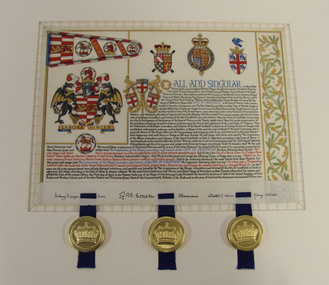
Letters Patent, Letters Patent for the Grant of Arms to the City of Caulfield presented on 1st May, 1977, 01/05/1977
... and later the town and city. In 1969 Caulfield City Council began... and city. In 1969 Caulfield City Council began planning to apply ...Glen Eira has a long history of association with various heraldic forms. From its early years the municipality of Caulfield had used the armorial bearings of the Caulfield Family (the Charlemonts of Castle Caulfield) to represent the roads board and later the town and city. In 1969 Caulfield City Council began planning to apply for an official coat of arms for the City. In 1974 Horace Hall, a Balwyn North resident and member of the Heraldry Society in London advised Council that the current usage was illegal, and that the Houston family, current owners of the Caulfield Arms could take legal action against Council for 'usurping their arms'. Mr Hall was commissioned to develop new heraldry for the City, and in conjunction with J. P. Brooke Little at the College of Arms, London, he prepared an acceptable design for Caulfield's Coat of Arms. The Council paid an additional sum to have a standard painted on the Letters Patent and the municipality's new coat of arms was drawn up in June 1975. The Coat of Arms retains a number of heraldic elements from the original Caulfield family insignia, including the dragons, the colours and the elements of the shield. The newly registered coat of arms and Letters Patent document for the granting of arms was presented at a civic service to mark the granting of armorial ensigns and the city banner to the City of Caulfield on the 1st May 1977. Significant elements of the coat of arms granted by these Letters Patent are as follows: The motto 'Labore Vinces' translates to 'By our labours we will conquer'. The helmet represents the rank of the owner. Public authorities are granted an esquire's helmet. The brickwork on the crest is a recognised emblem of local government. The Letters Patent also display a banner and a badge, both official symbols of the City of Caulfield. The badge, which is displayed on the banner as well as on its own, features a bridled horse. This represents the importance of racing, the Caulfield racecourse and the Caulfield cup to the municipality. These letters patent officially proclaim the granting of the coat of arms to the City of Caulfield. They are highly significant to the City of Glen Eira as they are the primary document that signifies the official and ceremonial heraldic powers of the Coat of Arms of the City of Caulfield. Mounted Letters Patent illuminated document for the Grant of Arms to the City of Caulfield presented on 1st May, 1977. Hand written and hand painted on cream coloured parchment using different coloured inks, mainly black, blue, red and gouache and gold paint. The bottom edge is folded up over itself approx. 45mm revealing the flesh side of the parchment, which displays black ink signatures and three sets of two horizontal slits that hold three blue ribbon. The ribbons support three wax seals in round, gold coloured metal cases held by the wax through slots in the casing. Although covered by the cap top, each wax seal within displays a different flag emblem with a crown on top, surrounded by a ring of text (difficult to read), noted when the cases were opened during conservation treatment. See attached transcription.arms, symbol, heraldry, glen eira, council, caulfield -
 Glen Eira Historical Society
Album - Album page, Booran Road, 30, Circa 1972
... ) and Caulfield City Council to identify historic buildings within...) and Caulfield City Council to identify historic buildings within ...This photograph is part of the Caulfield Historical Album 1972. This album was created in approximately 1972 as part of a project by the Caulfield Historical Society to assist in identifying buildings worthy of preservation. The album is related to a Survey the Caulfield Historical Society developed in collaboration with the National Trust of Australia (Victoria) and Caulfield City Council to identify historic buildings within the City of Caulfield that warranted the protection of a National Trust Classification. Principal photographer thought to be Trevor Hart, member of Caulfield Historical Society. Most photographs were taken between 1966-1972 with a small number of photographs being older and from unknown sources. All photographs are black and white except where stated, with 386 photographs over 198 pages. From Glen Eira Heritage Management Plan 1996 by Andrew Ward: In 1888, John Leek, a trainer, owned Lot 15, measuring one and three quarter acres, in Booran Road, north side between Glen Eira and Neerim Roads. The land backed onto the Caulfield Racecourse Reserve. NAV was £45. In 1890 Leek built for his residence, a ten roomed brick house on the site. NAV was £200. Leek was the owner/trainer of "Ingliston" who won the Caulfield Cup in 1900. Upon the horse's death in 1901, Leek is understood to have defied tradition by spending £20 on boots for the "ragged urchins in Bourke Street" instead of "shouting" at the bar. By 1899, the property was owned and occupied by Alfred Merrill, a dentist and was known as "Andover". NA V had decreased to £ll0. By 1910, Leslie Macdonald, a gentleman had purchased the property and renamed it "Moidart". In 1910-11 Macdonald sold it to John Robertson. The property had extensive wood stables on its north-east boundary and several other outbuildings. The house continued to be described as "Brick, ten rooms" as it was in 1926 when it was owned and occupied by John Arthur, a managing director. The land measured la.2r.31p. and had a NAV of £235. Nine people lived there. In 1926, Arthur also owned the adjoining Lot 16. Other racehorses of note, known to have been stabled here include Sobar, Havelock, Proud, Future and Lord.Victorian Heritage Register https://vhd.heritagecouncil.vic.gov.au/places/13532 What is significant? Lord Lodge is a thoroughbred racehorse training complex adjacent to Caulfield Racecourse, established in 1890. The area immediately around the racecourse has been associated with horse racing activities and businesses servicing the industry since the development of the racecourse in late the 19th century. Lord Lodge was named by the present occupants after the champion racehorse Lord who was stabled there in the 1950s. In the early 20th century the property was known as 'Andover' and subsequently 'Moidart'. The site consists of a single storey brick Italianate villa, jockeys' quarters, stables and open day yards with direct access to Caulfield racecourse from the rear of the property. The villa of 10 rooms on bluestone foundations was constructed in 1890 by John Leek, a horse trainer who purchased the newly subdivided land in 1888. The house has many Victorian Italianate or Boom Style features although it is more modest than many villas of its style. It has an asymmetrical facade with a faceted bay window and a prominent central tower with low pitch pyramidal roof that provides a clear view of the racecourse. Other characteristic features include stilted segmented arches, bracketed eaves, stucco wall finish and cast cement ornamentation. A room has been added on the north-facing verandah in sympathetic style and finish. Internally the rooms are substantially intact with original marble fireplaces and intricate ceiling roses and cornices. An entrance toward the rear of the southern side of the house is said to be where the stable hands, jockeys and other staff lined up for their meals. In the southeast corner of the property, backing directly on to Caulfield racecourse, is a substantial late Victorian timber stable, probably constructed in the 1890s but first appearing on the property title in 1910. The stable has 12 stalls, a loft and brick pavement and jerkin head roof form with varnished pine-lined ceiling carried on a chamfered timber frame. It has an original roof lantern. The doors of the stalls are not the original sliding doors but swing doors obtained from a barn at Epsom Racecourse in Mordialloc prior to demolition. Outside the gambrel roof has fretted barges but the building is otherwise utilitarian. Timber throughout the stalls has been worn by chewing and rubbing of horses over the century of its use. In the southern half of the property are open day yards where the racehorses are kept during the day. The red brick, single storey jockeys' quarters to the rear of the villa were probably built around 1950. A small brick, possibly late Victorian structure on the eastern boundary thought to have originally been a gardening shed, has been converted to a stable of two stalls. Modern concrete brick stables fill the northeast portion of the property. At the front of the property two Moreton Bay Figs (Ficus macrophylla), probably planted in the late 19th century, provide shade for horses in the day yards. In the 1890s John Leek sold the property, relocating his training facility to one of the newly established racecourses at Mentone or Mordialloc (Epsom). By 1899, the property was owned and occupied by Alfred Merrill, a dentist, who named the property 'Andover'. In 1910 it was purchased by Leslie McDonald, a gentleman, and renamed 'Moidart'; sold in 1910-1911 to John Robertson; and again in 1926 to John Arthur, a racehorse owner. The Victorian Amateur Turf Club purchased the property in the late 1930s and since this time has been leased to racehorse trainers. It is unclear whether the property operated as a training facility between 1899 - 1926. Several notable trainers and jockeys are associated with Lord Lodge. The best known is Arthur 'Scobie' Breasley, Australia's most successful jockey who was apprenticed to trainer Pat Quinlan at Lord Lodge (then 'Moidart') from 1928 - 1935. Breasley rode winners of the Caulfield Cup in four successive years 1942-45 and again in 1952. John Leek, the original owner of Lord Lodge trained Ingliston, the 1900 Caulfield Cup winner. Along with 'Lord' a number of well known racehorses including Sobar, Havelock, Proud and Future were trained at Lord Lodge .....Page 40 of Photograph Album with three landscape photographs of the exterior of this house.Handwritten: 30 Booran Road [top right hand corner] / 40 [bottom right]trevor hart, jenny o'donnell, booran road, mansion, caulfield east, ingliston, sobar, havelock, proud, future, lord, andover, moidart, lord lodge, grace darling, caulfield racecourse reserve, victorian amateur turf club, historic buildings register, national estate register, caulfield cup, horses, stables, horse racing, racehorses, outbuildings, racehorse trainers, depression, 1890s, brick houses, mansions, towers, verandahs, stained glass, italianate style, victorian style, architectural features, architectural styles, john leek, leslie macdonald, john arthur, john robertson, alfred merrill, jenny odonnell -
 Glen Eira Historical Society
Letter - CAULFIELD CENTENARY - 1957
... Meeting of Caulfield City Council to commemorate the 100th... Meeting of Caulfield City Council to commemorate the 100th ...This file contains seven items: 1/One double sided pamphlet regarding the Caulfield Centenary Carnival at Caulfield Park from 25/10/1957 to 05/11/1957, listing attractions and special events. Includes advertising for Bunny Industries on the back. 2/One pamphlet for the Children’s Carnival at Caulfield Racecourse on 29/10/1957 as part of the City of Caulfield Centenary celebrations. The pamphlet includes a timetable for the day’s events. 3/One six page pamphlet for a film festival organised by the Caulfield Film Society as part of the City of Caulfield Centenary Celebrations. The pamphlet includes a programme for each of the four days of the film festival, 14/10/1957, 17/10/1957, 23/10/1957 and 25/10/1957. The pamphlet also includes information about the Caulfield Film Society regarding their formation, their values, their manifesto and their officials. 4/An eight page programme for the centenary Thanksgiving Service on 13/10/1957 featuring prayers and hymns. 5/Two copies of a pamphlet regarding City of Caulfield Centenary Celebrations from 13/10/1957 to 05/11/1957 created by H.G. Nelson, Town Clerk. Events listed include Thanksgiving Service, Music Festival, Film Festival, Special Centenary Council Meeting, Gymkhana, Parade of Decorated Floats, Spring Flower Show, Massed Bands Display, Display of Art, Naturalisation Ceremony, Solemn High Mass, carnivals and plaque unveiling. 6/One original and one photocopy of an eight page notice paper for the Special Meeting of Caulfield City Council to commemorate the 100th Anniversary of the proclamation and declaration of the Caulfield Road District, to be held on 15/10/1957. The booklet includes the agenda, a council summons, a picture of Caulfield’s City Hall and a list of current and past councillors, chairmen, presidents, mayors and Shire Secretaries and town clerks. 7/A letter addressed to F. Campbell from Hazel Da Costa, dated 07/11/1997 regarding the acquisition of pamphletts for the Caulfield Centenary Carnival. For further information refer to the Oakleigh and Caulfield Times 09/10/1957 and Caulfield-Elsternwick Advertiser 05/11/1957 and 22/10/1957 stored in the Newspaper Archive room 4.caulfield centenary carnival, queen crowning ceremony, dandh bunny pty ltd, caulfield film society, carnegie memorial hall, caulfield park, hawthorn road, balaclava road, glenhuntly road, parades and processions, fire works displays, festivals and celebrations, bunny industries, glen press, hardware stores, builders suppliers, plumbers suppliers, centenary celebration, caulfield centenary, children’s carnival, caulfield racecourse, sinclair a.j.g., sporting events, film festival, new supper room, town hall, methodist hall, saint john hall, birch street, orrong road, princes park, caulfield hospital, daughters e.f., ward miss n., madigan mr. r, ritchie miss e., weichelt mr f., machin l.r., green w.c., jenner e.r., thomas w.r., centenary thanksgiving service, hymns, prayers, naturalisation ceremony, caulfield and district horses and pony club, special centenary council meeting, caulfield horticulture society, saint aloysius church, packer reserve, oakleigh road, caulfield memorial youth centre, commemoration, caulfield road district, mayors, presidents, chairmen, councillors, town clerks, parton e.m., bunny f.c.d., sims h.e., thomson w.r., wallace g.e., gunn e.e., gamble h.a., yorston j.s., handasyde g., murry ross w., stephen j.w., masters s., lloyd j.c., watts thos., watts t., nelson c., webb g.h., stephen f.j., crosbie j.w., watts w.c., holland j.c., lempriere w.g., millar w., newing t. r., ballantyne j., cotton a.d., long j., kirkham c.f., lloyd c.du p., wood f.g., akhurst a.c., riddell w.j.c., sharp t.c., phillips r.l., lempriere j.t., bayston w.s., dunbar a., hall p., saint j., fiske w., thompson h., murphy e.c., eggleston f.w., murray n.l., wood h.s., tyner w., wharington w.a., packer j.t., falls t., brooks w.r., lord r.h., morris a.e., page j.w., porter f.w., england e.f.s, patton r.t., mcculloch r., richie h.g., packer j.t., mackinnon d.c., mackinnon g.a., smith h.c.h., shillabeer f.e., pullman c.a., stewart l.mcr., tyers s.w., morris t.w., prior p.l., brooks w.r., webster h.c., sims h.e., prior p.l., thomson w.r., gunn e.e., parton e.m., wallace g.e., dempsey w., hart j., jowett f., briggs j.r., nelson h.g. -
 Glen Eira Historical Society
Album - Album page, Kambrook Road, Circa 1972
... ) and Caulfield City Council to identify historic buildings within...) and Caulfield City Council to identify historic buildings within ...This photograph is part of the Caulfield Historical Album 1972. This album was created in approximately 1972 as part of a project by the Caulfield Historical Society to assist in identifying buildings worthy of preservation. The album is related to a Survey the Caulfield Historical Society developed in collaboration with the National Trust of Australia (Victoria) and Caulfield City Council to identify historic buildings within the City of Caulfield that warranted the protection of a National Trust Classification. Principal photographer thought to be Trevor Hart, member of Caulfield Historical Society. Most photographs were taken between 1966-1972 with a small number of photographs being older and from unknown sources. All photographs are black and white except where stated, with 386 photographs over 198 pages. https://vhd.heritagecouncil.vic.gov.au/places/43737 - re 26 Kambrook Road and 345 Balaclava Road corner building: A prominently situated two-storeyed complex of late Victorian buildings consisting of "Wybar's Buildings" occupying the Balaclava Road/ Kambrook Road corner and the "Caulfield Bakery" facing Kambrook Road, separated by a driveway from a single storeyed shop. The main building has a comer splay and balustraded parapet with curved pediments, the words "Wybar's Buildings 1887" having been obliterated but "Caulfield Bakery 1887" with the characteristic wheatsheaf surviving in raised cement work. The walls are stuccoed and richly ornamented with bracketed cornices and keystones with masks extending to the Bakery. The main building is further distinguished by the Masonic symbol of the mason's dividers in the pediment whilst the upper level of the bakery is in overpainted brickwork. The single storeyed shop incorporates the bracketed cornice and consoles characteristic of the main buildings and is in other respects a utilitarian structure. https://vhd.heritagecouncil.vic.gov.au/places/35413 - re 16 Kambrook Road A small late Victorian Italianate villa distinguished by its parapeted window bays either side of a small verandah with encaustic tiled floor. The parapets are balustraded with console enrichment and glazed tiles, the stuccoed surfaces being unpainted. Ornamentation is in other respects undistinguished. https://www.gleneira.vic.gov.au/services/planning-and-building/heritage/heritage-management-plan - re 9-11 Kambrook Road ... they demonstrate most of the commonly employed aesthetic devices characteristic of the Italianate Style including patterned brickwork, patterned slate roofs, cast iron lace verandahs, ornamental stucco work and ashlar boards...https://vhd.heritagecouncil.vic.gov.au/places/43737 - 345 Balaclava and 26 Kambrook Roads HO91 in City of Glen Eira "Wybar's Buildings" at the corner of Balaclava Road and Kambrook Road are important as a prominent late Victorian commercial development incorporating a variety of activities including a bakery and possibly a coffee palace, the latter understood to be unique within the municipality, but characteristic of the period. It is a rare complex of its type in Caulfield and is important also as evocative evidence of the late Victorian Land Boom and the creation of a small now defunct commercial centre at this location by the George Wybrow. https://vhd.heritagecouncil.vic.gov.au/places/35413 - 16 Kambrook Road HO121 in City of Glen Eira ''Hollywood'' at 16 Kambrook Road is of architectural interest for its pavilions which retain their unpainted parapets and ornamental tiles in the manner of other less imposing examples in the immediate locality possibly linked with the builder George Wybar and his son, who undertook substantial projects nearby. Its association with James Yorston, presumably is Yorston of Dickson and Yorston, important builders and estate developers at Caulfield during the Inter war period is of interest. https://www.gleneira.vic.gov.au/services/planning-and-building/heritage/heritage-management-plan - re 9-11 Kambrook Road HO152 Normanby Road/Kambrook Road, Caulfield North Statement of Significance: The Precinct is historically significant for its capacity to demonstrate standards of design and building construction in this part of the municipality during the late Land Boom years and especially just prior to the bank collapse of 1891. The housing stock is representative of the standards of amenity excepted by the middle classes of Melbourne society at the time, including artists, (horse) trainers, jockeys, managers, travellers, journalists and the like, also having a functional link with the activities of the Caulfield Racecourse which forms an important element in the history of the Municipality. The row of attached pairs at 5-11 Kambrook Road and 53-67 Kambrook Road is especially significant in this respect in that the narrow allotments are indicative of the owner/developer’s determination to maximise profits at the height of the Land Boom in 1891...Page 104 of Photograph Album with four photographs (landscape) of three different properties on Kambrook Road.Handwritten: Kambrook Road [top right] / WYBAR'S BUILDING 1887/ INC CAULFIELD BAKERY / [under top right photo] / 16 KAMBROOK ROAD / 1970 HIRST MRS J.N.[under bottom left photo] / 11-9 KAMBROOK ROAD / 1970 9-BUCKLAND MRS L.A / 11- ATKINS MRS N.E. [under bottom right photo] / 104 [bottom right]trevor hart, kambrook road, victorian, caulfield north, parapets, wybar's buildings 1887, caulfield bakery 1887, architectural features, painted bricks, balaclava road, victorian italianate style, houses, bay windows, verandahs, glazed tiles, shops, george wybar, builders, james yorston, dickson and yorston, j n hirst, l a buckland, n e atkins, patterned slate roofs, patterned bricks, cast iron work, attached houses -
 Glen Eira Historical Society
Album - Album page, Kambrook Road, Circa 1972
... ) and Caulfield City Council to identify historic buildings within... (Victoria) and Caulfield City Council to identify historic buildings ...This page of photographs is part of the Caulfield Historical Album 1972. This album was created in approximately 1972 as part of a project by the Caulfield Historical Society to assist in identifying buildings worthy of preservation. The album is related to a Survey the Caulfield Historical Society developed in collaboration with the National Trust of Australia (Victoria) and Caulfield City Council to identify historic buildings within the City of Caulfield that warranted the protection of a National Trust Classification. Principal photographer thought to be Trevor Hart, member of Caulfield Historical Society. Most photographs were taken between 1966-1972 with a small number of photographs being older and from unknown sources. All photographs are black and white except where stated, with 386 photographs over 198 pages. First 2 images: milkbar and residence corner Kambrook and Balaclava Roads ie south west corner - building named Airdrie 3rd image: https://vhd.heritagecouncil.vic.gov.au/places/43737 - re 26 Kambrook Road and 345 Balaclava Road corner building ie south east corner: A prominently situated two-storeyed complex of late Victorian buildings consisting of "Wybar's Buildings" occupying the Balaclava Road/ Kambrook Road corner and the "Caulfield Bakery" facing Kambrook Road, separated by a driveway from a single storeyed shop. The main building has a comer splay and balustraded parapet with curved pediments, the words "Wybar's Buildings 1887" having been obliterated but "Caulfield Bakery 1887" with the characteristic wheatsheaf surviving in raised cement work. The walls are stuccoed and richly ornamented with bracketed cornices and keystones with masks extending to the Bakery. The main building is further distinguished by the Masonic symbol of the mason's dividers in the pediment whilst the upper level of the bakery is in overpainted brickwork. The single storeyed shop incorporates the bracketed cornice and consoles characteristic of the main buildings and is in other respects a utilitarian structure. 4th image: https://vhd.heritagecouncil.vic.gov.au/places/42415 (on 24/01/2021) - 196 Kambrook Road An imposing late Victorian poly-chrome brick asymmetrical villa with corner verandah and projecting west facing wing with faceted window bay to the facade. Body bricks are red and relieved by cream and black brick banding and by cream bricks to the bracketed eaves. The fretted barge with king post treatment and timber posted verandah are unique in the Municipality and unusual in the metropolitan area and demonstrate an understated appreciation of the emerging Queen Anne mode.345 Balaclava and 26 Kambrook Roads HO91 - City of Glen Eira https://vhd.heritagecouncil.vic.gov.au/places/43737 (on 24/01/2021) "Wybar's Buildings" at the corner of Balaclava Road and Kambrook Road are important as a prominent late Victorian commercial development incorporating a variety of activities including a bakery and possibly a coffee palace, the latter understood to be unique within the municipality, but characteristic of the period. It is a rare complex of its type in Caulfield and is important also as evocative evidence of the late Victorian Land Boom and the creation of a small now defunct commercial centre at this location by the George Wybrow. 196 Kambrook Road HO122 - City of Glen Eira https://vhd.heritagecouncil.vic.gov.au/places/42415 "Glencoe" is situated at no. 196 Kambrook Road, Caulfield North and was built for the boot manufacturer, Robert Bruce Mair, in 1888. It is of historic and aesthetic significance. It is historically significant (Criterion A) as the home of an inner suburban industrialist, notable a boot manufacturer, demonstrating the attraction of Caulfield as a residential location for the manufacturers of the metropolis during the late Victorian Boom period. It is aesthetically significant (Criterion E) as a very early example of a Queen Anne influenced late Victorian villa, comparing at the State level with ''Woodlands'' (1888), North Essendon, generally acknowledged to be one of Australia's earliest houses to fully exploit this emerging style. The ornamental timberwork is especially expressive of the new architectural fashion and compares with the house at 33 Clarence Street, Elsternwick (1888-89).Page 105 of Photograph Album with two photographs of a milk bar and attached residence, one older photograph of Wybar's Building and another photograph of a house on Kambrook Road (all are landscape).Handwritten: 196 KAMBROOK ROAD / 1970 - GAFFNEY MRS S.M. [under bottom right photo] / 100 [bottom left]trevor hart, kambrook road, victorian style, caulfield north, parapets, wybar's buildings 1887, caulfield bakery 1887, architectural features, painted bricks, balaclava road, george wybrow, shops, milk bars, airdrie, polychrome bricks, verandahs, queen anne architectural style, houses, glencoe, robert mair -
 Glen Eira Historical Society
Album - Album page, Labassa Conservatory, 21 Manor Grove, Circa 1972
... ) and Caulfield City Council to identify historic buildings within...) and Caulfield City Council to identify historic buildings within ...This photograph is part of the Caulfield Historical Album 1972. This album was created in approximately 1972 as part of a project by the Caulfield Historical Society to assist in identifying buildings worthy of preservation. The album is related to a Survey the Caulfield Historical Society developed in collaboration with the National Trust of Australia (Victoria) and Caulfield City Council to identify historic buildings within the City of Caulfield that warranted the protection of a National Trust Classification. Principal photographer thought to be Trevor Hart, member of Caulfield Historical Society. Most photographs were taken between 1966-1972 with a small number of photographs being older and from unknown sources. All photographs are black and white except where stated, with 386 photographs over 198 pages. WHAT IS SIGNIFICANT? [From Victorian Heritage Database citation for Former Labassa Conservatory - H2005 Victorian Heritage Register http://vhd.heritage.vic.gov.au/places/result_detail/12504 (25/01/2021)] The former Labassa Conservatory is believed to have been built as part of the extensive reworking of the Labassa estate in c1890 for the new owner Alexander Robertson, proprietor of the Cobb and Co line. Robertson commissioned the architect JAB Koch to remodel the house, and Koch may have been responsible for the conservatory as well. Alternatively, the conservatory may have been imported. The gates installed at Labassa in 1890 were manufactured by the MacFarlane foundry of Glasgow, Scotland, a firm known to have manufactured conservatories. Around 1917 the glass house from 'Labassa', Caulfield was offered for sale to Malvern Council for its own gardens but the offer was declined. Following subdivision of the Labassa estate in the 1920s the conservatory was converted into a residence. The structure has a simple rectangular plan, with a brick base and superstructure of cast iron columns and roof trusses. The hipped roof is surmounted by an elaborately decorated gable structure. Most of the original glass has been replaced by metal sheeting. The decoration comprises pressed metal fascias including an egg and dart style cornice moulding, mullion mouldings and gable end panels with a rising sun motif. Cast iron ridgework and finials add to the lively roof form. Internally the floor appears to have been raised as part of the conversion work to a residence, and stained timber panelling introduced to provide room spaces. Boilers probably heated the conservatory in the colder months, but these do not survive.From Victorian Heritage Database citation for Former Labassa Conservatory - H2005 http://vhd.heritage.vic.gov.au/places/result_detail/12504 (25/01/2021) HOW IS IT SIGNIFICANT? The former Labassa Conservatory is of historical and architectural significance to the State of Victoria. WHY IS IT SIGNIFICANT? The former Labassa Conservatory is historically significant for its associations with the Labassa estate. Subdivision of the estate separated a number of outbuildings from the mansion. The former conservatory is significant as part of the large scale improvements carried out to the estate in the 1890s. The nineteenth century was the great age of conservatory designs, enabled by technological developments in heating, glazing and iron. Whilst conservatories were common in botanical gardens and universities, where they were primarily used for cultivating, studying, and experimenting with plants, they had also become an accessory of the wealthy on private estates. The former Labassa conservatory is architecturally significant as a rare example of a building type. Many Victorian mansion houses had attached conservatories, but detached conservatories were much less common. The only other detached example associated with a residence known to survive on its original site in Victoria is an earlier example at Warrock homestead, near Casterton. Conservatories attached to nineteenth century mansions are far more numerous. The Labassa example is very ornate, and its decoration draws on the versatility of pressed metal and cast iron. This highlights the dual purpose of the conservatory, as both a functional structure and a picturesque building on the Labassa estate. This building is unusual as an example converted to residential use. Page 130 of Photograph Album with one portrait photograph of Labassa's conservatory.Handwritten: "Labassa" conservatory 21 Manor Grove [top right] /130 [bottom right]bracketed eaves, caulfield north, labassa, balaclava road, orrong road, sylliott hill, alexander william robertson, ontario, john a. b. koch, john boyd watson, mouldings, 1920's, la bassa, manor grove, st kilda east, architects, john koch, greenhouses, gardens, plants, land subdivisions, gates, macfarlane foundry, brick, cast iron work, hipped roofs, gables, 1890's -
 Glen Eira Historical Society
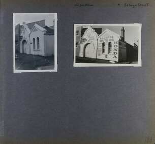
Album - Album page, Old Fire Station, 4 Selwyn Street, Circa 1972
... ) and Caulfield City Council to identify historic buildings within...) and Caulfield City Council to identify historic buildings within ...This album was created in approximately 1972 as part of a project by the Caulfield Historical Society to assist in identifying buildings worthy of preservation. The album is related to a Survey the Caulfield Historical Society developed in collaboration with the National Trust of Australia (Victoria) and Caulfield City Council to identify historic buildings within the City of Caulfield that warranted the protection of a National Trust Classification. Principal photographer thought to be Trevor Hart, member of Caulfield Historical Society. Most photographs were taken between 1966-1972 with a small number of photographs being older and from unknown sources. All photographs are black and white except where stated, with 386 photographs over 198 pages. From Victorian Heritage Database citation for H2376 Former Elsternwick Fire Station, 2-4 Selwyn Street Elsternwick - Victorian Heritage Register https://vhd.heritagecouncil.vic.gov.au/places/2645 (as at 21/11/2021) The Former Elsternwick Fire Station was built and commenced operation in 1896. It was one of 32 new fire stations built between 1892 and 1896 by the newly formed Melbourne Metropolitan Fire Brigade ('MFB') to form a comprehensive fire-fighting network across Melbourne. The MFB was established in 1891 as Victoria's government-run fire-fighting service in Melbourne and its growing suburbs. By 1918 motorised fire engine appliances had replaced horse-drawn fire vehicles across the metropolitan area, and the consequently larger areas that fire stations could protect meant the 1896 Elsternwick Fire Station was one of many which was becoming obsolete. The MFB continued to use the Elsternwick Fire Station up until the Station's closure in 1926. From 1927 the former Fire Station was leased by neighbouring timber merchants JJ Webster Pty Ltd who subsequently purchased the property from the MFB in 1934. From 1954 the 'Esquire Motors' car repair business traded at the site, and changes to the former Fire Station building including the complete enclosure of its yard by corrugated steel walls and roofing appear to have been completed in the mid-1950s. In 1990 the Australian Broadcasting Corporation ('ABC') purchased the former Fire Station together with five other adjoining land parcels in Selwyn Street. From that time until 2017 the former Elsternwick Fire Station has been used by the ABC as office and storage space in its Selwyn Street television studio complex.From Victorian Heritage Database citation for H2376 Former Elsternwick Fire Station, 2-4 Selwyn Street Elsternwick - Victorian Heritage Register https://vhd.heritagecouncil.vic.gov.au/places/2645 (as at 21/11/2021) The Former Elsternwick Fire Station is historically significant as one of the 10 remaining fire stations of the original 32 built for the newly established Melbourne Metropolitan Fire Brigade ('MFB') during the four-year period 1892 to 1896. These fire stations were constructed following the establishment in 1891 of the MFB, Victoria's government-run fire-fighting service for metropolitan Melbourne and its growing suburban population. These new stations formed a crucial part of the MFB's fire-fighting network across Melbourne. The Former Elsternwick Fire Station clearly demonstrates the historical development of fire-fighting services in Melbourne, especially the expansion of the newly-formed MFB throughout Melbourne's suburbs during the 1890s. [Criterion A] The Former Elsternwick Fire Station is architecturally significant as a fine example of a late nineteenth century fire station. Constructed shortly after the establishment of the MFB, it displays characteristics of its class of place that remain mostly unchanged from the former Station's historically important period of development and use. A particularly strong element of the Former Elsternwick Fire Station is the large and strikingly-detailed stone horseshoe arch, designed for horse-drawn fire-fighting vehicles, at the street entrance to its fire-engine room. [Criterion D]Page 188 of Photograph Album with two photographs of the old Elsternwick Fire Station.Handwritten: old fire station 4 Selwyn Street [top right] / 188 [bottom right]trevor hart, rendered, 1890's, melbourne metropolitan fire brigade, mfb, fire-fighting, jj webster, timber merchants, esquire motors, car repair, australian broadcasting corporation, abc, selwyn street, brick and stone, asymmetrical facade, anglo-dutch gable, rusticated and smooth-faced limestone, elsternwick fire station, elsternwick, fire station, jj webster pty ltd, motor vehicle repair shops, stone horseshoe arch entrance -
 Glen Eira Historical Society
Album - Album page, Bureel (Kooyong Road), Circa 1972
... ) and Caulfield City Council to identify historic buildings within...) and Caulfield City Council to identify historic buildings within ...This photograph is part of the Caulfield Historical Album 1972. This album was created in approximately 1972 as part of a project by the Caulfield Historical Society to assist in identifying buildings worthy of preservation. The album is related to a Survey the Caulfield Historical Society developed in collaboration with the National Trust of Australia (Victoria) and Caulfield City Council to identify historic buildings within the City of Caulfield that warranted the protection of a National Trust Classification. Principal photographer thought to be Trevor Hart, member of Caulfield Historical Society. Most photographs were taken between 1966-1972 with a small number of photographs being older and from unknown sources. All photographs are black and white except where stated, with 386 photographs over 198 pages. From: Glen Eira Heritage Management Plan 1996 by Andrew Ward In 1856, John Allee, a builder from Brighton, purchased C.A. 37 on the south-west corner of Glenhuntly and Kooyong Roads. The land comprised just over 45 acres. By 1863, Francis John Sidney Stephen, a lawyer and cousin of J. Wilberforce Stephen, owned most of lot 37. By 1866, Stephen had a built a "small mansion" named ''Burreel". It was a brick house and Stephen lived there until 1882. By 1884, Mrs Buxton of Hillside Terrace, East Melbourne, had purchased the property. Richard Buxton, a gentleman was listed as occupant and the house described as "brick, eight rooms". NAV was £300. Richard Buxton continued residency in 1887 however in 1888, George Allen, music seller, became occupant. At that time the house had thirteen rooms on twenty-three acres of land. Twelve people lived there and NAV was £920. In 1900, Daniel Luxton, stock and sharebroker and the Honourable John Taverner, M.H.A. leased the property. Fourteen people lived there. Mrs Buxton continued as owner. By 1910, ownership had passed to Mrs Mary Neate, who converted the house to a nursing home. The land had been subdivided by 1913 and sold by ''Buxtons Estate". Burreel Avenue, Baxter, Buxton and Hoddle Streets were created. "Burreel" was rated to Burreel Avenue and stood on lot 13 with frontages to Burreel Avenue and Kooyong Road of 198' and 214'. The house had ten rooms. NAV was £60. Mary Neate, a nurse, continued as owner/ operator of ''Burreel" nursing home in 1927. At that time there were sixteen rooms and fourteen residents. NAV was £100. Mrs Neat remained there until 1947. In 1948, the house was turned into apartments. In the 1980's, the Alexander family purchased it and restored it to a private residence.Burreel 331 Kooyong Road, ELSTERNWICK VIC 3185 - Property No B4950 National Trust https://vhd.heritagecouncil.vic.gov.au/places/65648 This is a large and substantially intact example of the grand villas of nineteenth century Melbourne. The bulk of the house most probably was built in 1866-1868 for Francis John Sidney Stephen, a prominent and highly regarded Melbourne solicitor and a member of an illustrious legal family. Stephen conducted a lucrative private practice and in 1845 was appointed first solicitor to the City of Melbourne; a position he held until his death in 1895. He took an active part in the development of Caulfield and was Shire President in 1874 and 1877. He was a resident at Burreel from 1868 to 1882. The house has evolved in stages, the rear wings possibly remaining from a house built during the 1850s. The existing ornate cast iron verandah was probably built between 1882 and 1888 during the residence of Richard Buckhurst Buxted, a notable boom period auctioneer and real estate agent. George Allan, the founder of Allan's music store, was another important occupier from 1888 to 1991. Bureel's essentially residential quality has been retained and the interior has been well preserved. The significance of this building does not rest in any single unusual outstanding architectural feature, or in its association with a particularly prominent member of society in the past, but rather in the consistent integrity of both the interior and exterior, which results in the survival of an outstanding example of this type of residential building and its associations with two notable citizens. Classified:11/08/1990Page 113 of photograph album with 1 photograph of Burreel in its garden.Handwritten: Bureel [top left] / 113 [bottom left]trevor hart, caulfield, caulfield north, kooyong road, thomas king, mansion, 1860's, bureel, burreel, francis john sidney stephen, city of melbourne, shire president, 1850's, verandah, nursing home, john allee, ornamented corner stones, new orleans manner, plaster rendered, mrs luxton, vincent willis, alexander family, victorian architectural style, ornate cast iron work, lawyers, brick houses, richard buxton, richard buckhurst buxton, george allen, george leavis allan, allans music, daniel luxton, john taverner, mary neate, buxtons estate, land subdivision, mary neat, gardens -
 Glen Eira Historical Society
Album - Album page, Labassa, 4 Manor Grove, Circa 1972
... ) and Caulfield City Council to identify historic buildings within...) and Caulfield City Council to identify historic buildings within ...This photograph is part of the Caulfield Historical Album 1972. This album was created in approximately 1972 as part of a project by the Caulfield Historical Society to assist in identifying buildings worthy of preservation. The album is related to a Survey the Caulfield Historical Society developed in collaboration with the National Trust of Australia (Victoria) and Caulfield City Council to identify historic buildings within the City of Caulfield that warranted the protection of a National Trust Classification. Principal photographer thought to be Trevor Hart, member of Caulfield Historical Society. Most photographs were taken between 1966-1972 with a small number of photographs being older and from unknown sources. All photographs are black and white except where stated, with 386 photographs over 198 pages. HISTORY:-- From Victorian Heritage Database citation for Labassa https://vhd.heritagecouncil.vic.gov.au/places/278 as at (26/10/2020) Labassa, Caulfield is one of Melbourne's most lavishly decorated nineteenth century mansions. It resulted from the extensive remodelling in 1890, of an earlier house, known as Sylliott Hill, which was begun in 1862-3 for lawyer, Richard A. Billing. The land at the corner of Balaclava and Orrong Roads was first acquired in 1854 by William Lyall, transferred to his partner, John Mickle, in 1859, who also acquired the adjoining allotment in Balaclava Road, and the three allotments were conveyed to Billing. His first eight-roomed house was extended significantly in 1873 into a twenty-roomed house by architects Crouch and Wilson, who were possibly also responsible for the first house. This reflected Billing's success as a barrister, and he resided at this property until his death in 1882. In 1883 prominent Melbourne businessman, Alexander William Robertson, leased the Sylliott Hill property from Billing's widow, and in 1885 he purchased the adjoining allotment in Balaclava Road. He purchased the Billing's property in 1887 and renamed the 6.31 hectare property, Ontario. In 1889-90, Robertson commissioned the German born architect, John A. B. Koch, to extensively remodel the house into a thirty-five roomed mansion. The existing house was extended and altered, largely resulting in the nineteenth century mansion as it now appears. After Robertson's death in 1896, the house was tenanted until it was eventually sold to the mining millionaire, John Boyd Watson, in 1904. He renamed the property Labassa and carried out repair and re-decoration work to the house. In the early twentieth century, many large estates were subdivided into smaller allotments as the demand for land grew and it became difficult to maintain such large estates. After Watson's death in 1911, portions of the Labassa estate were offered for sale, with Mrs Watson retaining a 1.73 hectare portion containing the house. In 1913 forty-six allotments were auctioned at Labassa Estate, with the formation of Labassa Grove and Ontario Street to the east of the property. Labassa was first recorded as containing flats in 1923 and in the late 1920s, the owner, Robert Hannon, built a red brick block of flats adjacent to the house. Subdivision continued, until the National Trust of Australia (Victoria) purchased the house in 1980 and subsequently purchased adjoining sites, one to the south-east in 1984 (house demolished in 1988) and to the west in 1988. Labassa as it now stands is substantially as it appeared when Koch completed the work in 1890. The original two storey house was transformed into a French Renaissance style mansion, with the addition of a two level L-shaped arcaded verandah and two prominent terminating bays to the south and the east. The building is of unpainted cement render with dressed bluestone plinths, balustraded parapet and steep, slate covered, flat topped mansard roofs behind. A truncated conical roof is a feature of the south bay and a helmeted head is incorporated in the parapet over the east bay. The main south and east facades incorporate many cast cement details, including sculptures, elaborate cornices, swagged Corinthian columns and caryatid consoles flanking the entrance porch, as well as pink marble panels and imitation marble, or scagliola, on curved surfaces. At the rear of the building is a two storey wing and a single storey cottage, the former being connected to the main house by a tower. This section of the house was constructed in 1873. The estate at its peak included stables (1873), conservatory (probably 1890) and a tennis pavilion (probably 1890). All of these outbuildings survive, with the stables and conservatory being converted for residential use after 1922. Internally a range of decorative treatments remain from the late nineteenth century and the early twentieth century, both from the Robertson and Watson periods of occupancy. These include wallpapers, ceiling decoration, chimney pieces, mouldings, joinery and decorative glass. From Victorian Heritage Database citation for H0135 Labassa 2/2A Manor Grove Caulfield North https://vhd.heritagecouncil.vic.gov.au/places/278 as at (26/10/2020) HOW IS IT SIGNIFICANT? Labassa, Caulfield is of architectural, aesthetic and historical significance to the State of Victoria. WHY IS IT SIGNIFICANT? Labassa, Caulfield is of architectural significance as the most prominent example of a small number of houses built in Australia in the French Renaissance style. It is of further note due to the German interpretation of the style and the use of Hellenistic sources, via Germany. It is exceptional for its lavish treatment externally, including marble, scagliola, caryatids, swagged columns, mansard roofs and ornamental cresting. Labassa is of architectural significance as the most important surviving example of German architect, John Koch's domestic work. He undertook a large variety of work in Melbourne, including a number of houses, however Labassa is the most lavish example of his work. Labassa is of aesthetic significance for its outstanding assemblage of late nineteenth and early twentieth century European style interior decoration, which remain remarkably intact. These include a trompe l'oeil ceiling, painted ceilings, embossed imitation leather and other papers, chimney pieces, ceramic tilework, oak parquetry and stained glass, including a tripartite window by Ferguson and Urie, probably dating from the 1873 period. Labassa is of historical significance as an illustrative example of the wealth acquired by a number of prominent Victorian families in the second half of the 19th century. The early development of the property, Sylliott Hill, was due to the wealth acquired by Richard Billing, barrister and fifth Victorian to be appointed Queen's Counsel in 1878. The significant development in 1890 of Ontario, is illustrative of the wealth of Alexander Robertson, a partner in Cobb and Co., a director of Goldsborough Mort & Co., and a pastoral speculator. John B. Watson, whose father had acquired great wealth from the goldfields of Bendigo and subsequently invested in city and country properties, was the third resident to impact on the house, particularly the interiors. The Labassa estate is of historical significance as an illustrative example of the development that occurred in such suburbs as Caulfield in the 1880s due to the land boom, its proximity to Melbourne and the establishment of the Melbourne to Gippsland railway in 1879. It is also illustrative of an estate which succumbed to the pressures of subdividing in the early twentieth century, as properties became difficult to maintain and demand for land close to the city grew. It was typically divided into flats in the 1920s and was used as such for about sixty years. It is of historical significance for its associations with the remnants of the earlier estate which remain extant. These include the stables, conservatory (H2005) and tennis pavilion which all remain on separate sites. Also significant are the remains of early electrical wiring and fittings. Labassa was one of the first houses in Caulfield to be electrified and some of the original wires remain. [Online Data Upgrade Project 2004]Page 128 of Photograph Album with four photographs (two portrait and two landscape) of Labassa.Handwritten: "Labassa" 4 Manor Grove [top right] / Neg 232 8 Oct 1966 [under bottom right photo] / 128 [bottom right]trevor hart, bracketed eaves, slate roof, bay windows, decorative brackets, caulfield north, labassa, richard a. billing, balaclava road, orrong road, sylliott hill, william lyall, crouch and wilson, alexander william robertson, ontario, 1880's, john a. b. koch, mansion, john boyd watson, labassa grove, french renaissance style, l-shaped arcaded verandah, bluestone plinths, balustraded parapet, flat topped mansard roofs, conical roof, elaborate cornices, corinthian columns, caryatid consoles, marble panels, imitation marble, scagliola, tower, conservatory, stables, tennis pavilion, mouldings, decorative glass, caryatids, swagged columns, ornamental cresting, trompe l'oeil ceiling, embossed imitation leather, oak parquetry, stained glass, tripartite window, triple window, ferguson and urie, 1870's, flats, 1920's, electric wiring, 1860's, verandahs, curved windows, arched windows, italianate, terraces, gargoyles, ornamentation, ornate entrance, la bassa, manor grove, st kilda east, victorian, cast iron work, john koch, richard billing, architects, electrification, john mickle, land subdivision, mrs watson, labassa estate, robert hannon, national trust of australia (victoria), sculpture -
 Glen Eira Historical Society
Album - Album page, Labassa, 4 Manor Grove, Circa 1972
... ) and Caulfield City Council to identify historic buildings within...) and Caulfield City Council to identify historic buildings within ...This photograph is part of the Caulfield Historical Album 1972. This album was created in approximately 1972 as part of a project by the Caulfield Historical Society to assist in identifying buildings worthy of preservation. The album is related to a Survey the Caulfield Historical Society developed in collaboration with the National Trust of Australia (Victoria) and Caulfield City Council to identify historic buildings within the City of Caulfield that warranted the protection of a National Trust Classification. Principal photographer thought to be Trevor Hart, member of Caulfield Historical Society. Most photographs were taken between 1966-1972 with a small number of photographs being older and from unknown sources. All photographs are black and white except where stated, with 386 photographs over 198 pages. HISTORY:-- From Victorian Heritage Database citation for Labassa https://vhd.heritagecouncil.vic.gov.au/places/278 as at (26/10/2020) Labassa, Caulfield is one of Melbourne's most lavishly decorated nineteenth century mansions. It resulted from the extensive remodelling in 1890, of an earlier house, known as Sylliott Hill, which was begun in 1862-3 for lawyer, Richard A. Billing. The land at the corner of Balaclava and Orrong Roads was first acquired in 1854 by William Lyall, transferred to his partner, John Mickle, in 1859, who also acquired the adjoining allotment in Balaclava Road, and the three allotments were conveyed to Billing. His first eight-roomed house was extended significantly in 1873 into a twenty-roomed house by architects Crouch and Wilson, who were possibly also responsible for the first house. This reflected Billing's success as a barrister, and he resided at this property until his death in 1882. In 1883 prominent Melbourne businessman, Alexander William Robertson, leased the Sylliott Hill property from Billing's widow, and in 1885 he purchased the adjoining allotment in Balaclava Road. He purchased the Billing's property in 1887 and renamed the 6.31 hectare property, Ontario. In 1889-90, Robertson commissioned the German born architect, John A. B. Koch, to extensively remodel the house into a thirty-five roomed mansion. The existing house was extended and altered, largely resulting in the nineteenth century mansion as it now appears. After Robertson's death in 1896, the house was tenanted until it was eventually sold to the mining millionaire, John Boyd Watson, in 1904. He renamed the property Labassa and carried out repair and re-decoration work to the house. In the early twentieth century, many large estates were subdivided into smaller allotments as the demand for land grew and it became difficult to maintain such large estates. After Watson's death in 1911, portions of the Labassa estate were offered for sale, with Mrs Watson retaining a 1.73 hectare portion containing the house. In 1913 forty-six allotments were auctioned at Labassa Estate, with the formation of Labassa Grove and Ontario Street to the east of the property. Labassa was first recorded as containing flats in 1923 and in the late 1920s, the owner, Robert Hannon, built a red brick block of flats adjacent to the house. Subdivision continued, until the National Trust of Australia (Victoria) purchased the house in 1980 and subsequently purchased adjoining sites, one to the south-east in 1984 (house demolished in 1988) and to the west in 1988. Labassa as it now stands is substantially as it appeared when Koch completed the work in 1890. The original two storey house was transformed into a French Renaissance style mansion, with the addition of a two level L-shaped arcaded verandah and two prominent terminating bays to the south and the east. The building is of unpainted cement render with dressed bluestone plinths, balustraded parapet and steep, slate covered, flat topped mansard roofs behind. A truncated conical roof is a feature of the south bay and a helmeted head is incorporated in the parapet over the east bay. The main south and east facades incorporate many cast cement details, including sculptures, elaborate cornices, swagged Corinthian columns and caryatid consoles flanking the entrance porch, as well as pink marble panels and imitation marble, or scagliola, on curved surfaces. At the rear of the building is a two storey wing and a single storey cottage, the former being connected to the main house by a tower. This section of the house was constructed in 1873. The estate at its peak included stables (1873), conservatory (probably 1890) and a tennis pavilion (probably 1890). All of these outbuildings survive, with the stables and conservatory being converted for residential use after 1922. Internally a range of decorative treatments remain from the late nineteenth century and the early twentieth century, both from the Robertson and Watson periods of occupancy. These include wallpapers, ceiling decoration, chimney pieces, mouldings, joinery and decorative glass.From Victorian Heritage Database citation for H0135 Labassa 2/2A Manor Grove Caulfield North https://vhd.heritagecouncil.vic.gov.au/places/278 as at (26/10/2020) HOW IS IT SIGNIFICANT? Labassa, Caulfield is of architectural, aesthetic and historical significance to the State of Victoria. WHY IS IT SIGNIFICANT? Labassa, Caulfield is of architectural significance as the most prominent example of a small number of houses built in Australia in the French Renaissance style. It is of further note due to the German interpretation of the style and the use of Hellenistic sources, via Germany. It is exceptional for its lavish treatment externally, including marble, scagliola, caryatids, swagged columns, mansard roofs and ornamental cresting. Labassa is of architectural significance as the most important surviving example of German architect, John Koch's domestic work. He undertook a large variety of work in Melbourne, including a number of houses, however Labassa is the most lavish example of his work. Labassa is of aesthetic significance for its outstanding assemblage of late nineteenth and early twentieth century European style interior decoration, which remain remarkably intact. These include a trompe l'oeil ceiling, painted ceilings, embossed imitation leather and other papers, chimney pieces, ceramic tilework, oak parquetry and stained glass, including a tripartite window by Ferguson and Urie, probably dating from the 1873 period. Labassa is of historical significance as an illustrative example of the wealth acquired by a number of prominent Victorian families in the second half of the 19th century. The early development of the property, Sylliott Hill, was due to the wealth acquired by Richard Billing, barrister and fifth Victorian to be appointed Queen's Counsel in 1878. The significant development in 1890 of Ontario, is illustrative of the wealth of Alexander Robertson, a partner in Cobb and Co., a director of Goldsborough Mort & Co., and a pastoral speculator. John B. Watson, whose father had acquired great wealth from the goldfields of Bendigo and subsequently invested in city and country properties, was the third resident to impact on the house, particularly the interiors. The Labassa estate is of historical significance as an illustrative example of the development that occurred in such suburbs as Caulfield in the 1880s due to the land boom, its proximity to Melbourne and the establishment of the Melbourne to Gippsland railway in 1879. It is also illustrative of an estate which succumbed to the pressures of subdividing in the early twentieth century, as properties became difficult to maintain and demand for land close to the city grew. It was typically divided into flats in the 1920s and was used as such for about sixty years. It is of historical significance for its associations with the remnants of the earlier estate which remain extant. These include the stables, conservatory (H2005) and tennis pavilion which all remain on separate sites. Also significant are the remains of early electrical wiring and fittings. Labassa was one of the first houses in Caulfield to be electrified and some of the original wires remain. [Online Data Upgrade Project 2004]Page 129 of Photograph Album with three landscape photographs of Labassa. One of the photographs is of Labassa's drive and gates.Handwritten: 4 JUNE 1910 / SALE JUNE 28 1910 "LA BASSA' / "AUSTRALASIAN" FORMERLY "ONTARIO"/ RES OF JOHN B WATSON / 15 ACRES 3 ROADS [under bottom left photo] / 4 JUNE 1910 [under bottom right photo] / 129 [bottom left]trevor hart, bracketed eaves, intricate lacework, slate roof, bay windows, decorative brackets, caulfield north, labassa, richard a. billing, balaclava road, orrong road, sylliott hill, william lyall, crouch and wilson, alexander william robertson, ontario, 1880's, john a. b. koch, mansion, john boyd watson, labassa grove, french renaissance style, l-shaped arcaded verandah, bluestone plinths, balustraded parapet, flat topped mansard roofs, conical roof, elaborate cornices, corinthian columns, caryatid consoles, marble panels, imitation marble, scagliola, tower, conservatory, stables, tennis pavilion, mouldings, decorative glass, caryatids, swagged columns, ornamental cresting, trompe l'oeil ceiling, embossed imitation leather, oak parquetry, stained glass, tripartite window, triple window, ferguson and urie, 1870's, flats, 1920's, electric wiring, 1860's, verandahs, curved windows, arched windows, italianate, terraces, gargoyles, ornamentation, ornate entrance, la bassa, manor grove, st kilda east, gates, cast iron work, richard billing, architects, john koch, electrification, victorian style, drives, john mickle, land subdivision, mrs watson, labassa estate, robert hannon, national trust of australia (victoria), sculpture -
 Glen Eira Historical Society
Document - Japanese School of Melbourne
... of Melbourne that met with City of Caulfield councilors on 23/11/1988... of Melbourne that met with City of Caulfield councilors on 23/11/1988 ...Six documents about the Japanese School: 1/The Japanese School of Melbourne Planning Brief document draft February 1984 to the City of Caulfield. Brief includes background of school, current educational standards of school and structure, future plans, including forecast of future student numbers, request to use prefabricated rooms. Also plans for new building and room alterations. Includes appendice which has current and projection graph of students attending. Period covered: January 1968-February 1984 (17 pages). 2/Fourteen page school prospectus, which includes history and location, term dates, school hours, curriculum subjects, teachers qualifications, health department approval and enrolment list. Also includes Division of School Duties, school educational aims and guidance priorities. Period covered: 07/09/1968-13/05/1986. 3/An 11/11/1988 Melbourne Development and Prospectus for the Japanese School of Melbourne, includes purpose of school, development options, planning brief, construction time, and development program. Includes seven plans and maps of school location and bus routes (14 pages). Prepared for the City of Caulfield on its request. 4/List of representatives of the Japanese School of Melbourne that met with City of Caulfield councilors on 23/11/1988. 5/Black and white photo of 'Ian Rob with Japanese students September 1991', six students included. 6/Colour photograph of 'Mayor Ed Biggs with Japanese students February 1992', thirteen adults and young people included.japanese school of melbourne limited, japanese school, caulfield, holy cross catholic, holy cross school, ellington school, keeron street, mockridge stahle and mitchell architects, architects, secondary schools, primary schools, playgrounds, hawthorn road, caulfield south, yaji hidero, japanese community, yazaki yasuo, morita hiroshi, teachers, bloink des, stokes tony, building surveyors, japanese supplementary school of melbourne, school committees, libraries, school houses, brick, bloink clarke harding consulting architects group, anthony stokes and assoc. building surveyors and town planners, rob ian, biggs ed mayor -
Glen Eira Historical Society
Document - McKinnon Secondary College
File contains 3 items: 1) the school listing from the City of Moorabbin Community Directory Listing 1987, including information about the principal, mothers club and president of the school council 2) an advertisement for a school information night from the Caulfield/ Port Phillip Leader 19/05/2011 3) an advertisement for the school from the Leader News South Edition Dux 2010.mckinnon high school, mckinnon road, parents clubs, mckinnon secondary college, education, clubs and associations, lawrence alan, schools, donovan noel, colleges, mckinnon, school committees -
Glen Eira Historical Society
Document - Langdon Homes of Caulfield
... Town Hall Caulfield Shire Council Caulfield City Hall Lincluden ...One item encompassing three copies of this book: Two photocopies of the proof of the book The Langdon Homes of Caulfield by Irene Anderson published by Caulfield Historical Society in 1986. The book contains a history of the Langdon Family and their houses in Glen Eira: Rosecraddock, Lirrewa, Beemery, Hengar, Lincluden and Croton Hurst. Also one final print of this published book.the langdon homes of caulfield, caulfield historical society, rosecraddock, caulfield, langdon road, langdon philip, langdon marie, anderson irene, langdon henry joseph, hawthorn road, powderham road, kooyong road, craddock avenue, langdon elizabeth laetitia lane langdon, langdon montague william, roads board of caulfield, brighton cemetery, langdon edward henry, langdon charles petley, langdon john berry, langdon emily amy, langdon florence elizabeth, langdon laura, langdon blanche emma, beemery park, tarqua, renwick samuel, the garrell, glen eira road, seymour road, blanche street, lirrewa, renwick jane, read louise martha, freedman harold, langdon charles stanley blake, langdon richard read, langdon philip clark, langdon mary laetitia lane, langdon henry clive courtenay, elser lilian, st. mary’s church of england caulfield, keverell road, langdon richard berry, langdon charles hugh, topp mr., jamieson mr., tayler lloyd, mansions, balaclava road, crotonhurst avenue, langley h.t. rev., hengar, langdon henry, lirrewa grove, riddoch elizabeth helen, langdon leslie john, langdon mary elizabeth, langdon dorothy, langdon margery, caulfield town hall, caulfield shire council, caulfield city hall, lincluden, sinclair a.j., elsternwick, langdon madge, weddings, memorial services, beemery, beemery park estate, langdon clive, neringa, sadleir john, penleigh, garrell street, victorian style, croton hurst, webb george henry frederick, judges, langdon william farr, webb sophie sarah annie, webb dottie, mitchell road, caulfield racecourse, webb isabella, langdon frank henry webb, langdon george rupert webb, langdon mark, langdon webb, langdon isobel, langdon grace, langdon georgie, langdon violet, somers charles, mclaughlin j., walworth avenue -
Glen Eira Historical Society
Article - Spurway Nursing Home
The folder contains four items in two groups. 1) A Caulfield Contact article, vol 15, no 6, 27/07/1986, and a Caulfield Progress article dated 26/07/1989 describing the official opening of the Caulfield Spurway Nursing Home. 2) A typed copy of Caulfield Spurway Nursing Home Residency Agreement Proforma and a Commonwealth Department of Community Services document Common Form of Agreement regarding the temporary absence of a nursing home resident.nursing homes, murrumbeena road, spurway nursing home, opening ceremony, mayors, braun emil, parliamentary representative, tehan marie, councils, municipal government, local officials, chief executive officer, aylen doug, spurway homes, trustees, stephenson lyle, spurway jim, spurway trust, fundraising events, commonwealth government, state government, community groups, carnegie opportunity shop, caulfield voluntary workers shop, city of caulfield lions club, aged people nursing homes -
Glen Eira Historical Society
Article - Brunning, Leslie Herbert Ashby
An extract about Brunning’s Nurseries, St Kilda, taken from John Butler Cooper’s The History of St Kilda, from its first settlement to a city and after 1840 to 1930, Vol II. The extract is a short history of Brunning’s Nurseries, St Kilda. Includes a handwritten note by Deborah Towns citing the source, dated 08/07/2011.brunning george, brunning george edward, brunning herbert, brunning’s nurseries, g brunning and sons, st kilda, brunning street, brighton road, gardening, st kilda council, agricultural industry, commercial establishment -
Glen Eira Historical Society
Letter - Gardenvale Road, 78, Gardenvale
This file contains six items. Five items of typed correspondence concerning application to build four double-storey dwellings at 78 Gardenvale Road. Correspondence between City of Glen Eira and residents R.A. and P. Darke from 08/12/2008 to 20/03/2009, and Paul Siedle. Typed copy of resident Jonathon Breedon’s objections to the proposed plan. Copy of original plans for the dwellings dated 12/09/2008. Copy of amended plans for the four dwellings dated November 2008. Typed letter dated 20/03/2009 from Glen Eira Senior Town Planner to Richard and Peta Darke notifying of council’s decision of intention to grant a planning permit for the dwellings. Typed five page notice of decision to grant a planning permit for the four dwellings dated 20/03/09. Included is a one page description of the appeal process.gardenvale road, magnolia road, gardenvale, city of glen eira, city hall, glen eira road, hawthorn road, lloloma receptions, caulfield south, darke peta, darke richard, elster avenue, elsternwick, torres ron, kokkinos stella, glen eira city council, statutory planning department, breedon jonathon, lantana road, peter l. brown architects pty ltd., glen eira planning scheme, elsternwick library, bentleigh library, carnegie library, caulfield library, staniland grove, jasper road, shepparson avenue, bentleigh, carnegie, caulfield, siedle paul, townhouses, town planning, plans, aerial photographs, architectural drawings, architects, brick houses -
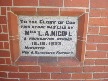 Glen Eira Historical Society
Article - St. Andrew’s Presbyterian Church, North Road, Gardenvale East
Handwritten document giving brief details on wording on foundation stone of St. Andrew’s church, undated and author unknown. Photocopy of pamphlet produced for the stewardship campaign 1957 for St. Andrew’s Presbyterian Church Gardenvale East, with several photos. It includes history as well as current situation at 1957. Photocopied notes and photo of the Army Hut used by Gardenvale Primary School in 1921 only as donated by church for and year then Reverted back to church use. Photocopy of letter to Glen Eira News and City Council re-proposed subdivision of church land from Robert W. Sinclair.st. andrew’s presbyterian church, foundation stones, nicoll l.a., heathcote-fletcher a. rev., north road, seach street, smith a. f.h. rev., mcneilage alex rev., gardenvale east, caulfield south, younger street, gardenvale east church, nicholls rev., rowlands w. rev., lang walter, sunday schools, yeaman f.e. rev., brown f.e., brick, towers, manse, choirs, groups, smith mrs., curtis e.e., morse roger, marryatt harry, pegler adrian, savill t., south caulfield, gardenvale primary school, sinclair robert w., dakin ms., campbell felicity -
Glen Eira Historical Society
Letter - St Aloysius Church, Caulfield
A series of correspondence dated between 21/08/1985 to 10/11/1988 regarding the Historic Buildings Council adding St Aloysius Church on Balaclava Road, Caulfield to the Historic Buildings Register. Four of the letters are between the Historic Buildings Council, the Caulfield Historical Society and the City of Caulfield. Copies of the replies by the Historical society (as indicated by handwritten notes in the letters) are not included in the file. A fifth letter dated 14/09/1989, addressed to Reverend Father John Fraser, Parish Priest at St Aloysius, advises him of the inclusion of St Aloysius on the National Trust Register due to its historic significance. Also included is a photocopy of the Caulfield Conservation study of St Aloysius, dated February 1994, by Andrew Ward. This study details the architectural features and historic significance of the church, recommending planning scheme control. It includes a front view photograph, which is not clear, and references.caulfield, catherine street, tonkin ray, st aloysius church, grey karen, fraser john rev. fr., catholic church, wills cathie, davies stephen, balaclava road, ballantyne r mr, ward andrew, city of caulfield, head stephen, moriarty bartholemew, de carle henry, mannix archbishop, caulfield historical society, caulfield conservation study, foundation stones, town halls, local officials and employees, registers, committees and inquiries, gothie (revival) architecture, architectural features. -
Glen Eira Historical Society
Book - Hillcrest Estate Draft Heritage Guidelines July 2000
2 items about Hillcrest Estate and heritage: 1/A 20 page report giving draft heritage guidelines by the City of Glen Eira for properties within the Hillcrest Estate Heritage Area of Caulfield South, including Hillcrest Avenue numbers 1 and 3-12 and Marara Road numbers 27 and 28. The Heritage Area has been assessed as noteworthy as 'the first housing estate developed by the AV Jennings Construction Co., later known as Jennings Group Limited.' Developed during the Depression years of the early 1930s, it is considered an 'unusually intact example of an interwar garden estate' and is also considered noteworthy for its aesthetic values. The Report describes typical features for two house forms typical of the area: the single-storey villa with decorative porch and the single storey villa with decorative verandah. It gives guidelines on the types of changes which can be made to houses within the Heritage Area. Included are photographs of typical houses and design features, maps, and diagrams showing acceptable zones for additions, amongst other Sections (eg. Key design checklist). 2/A three page photocopy taken from Andrew Ward's Heritage Study for The Hillcrest Estate Historic Area.hillcrest estate, glen eira heritage management plan, glen eira planning scheme, glen eira city council, hillcrest estate heritage area, hillcrest avenue, merri street, marara road, eumerella street, av jennings construction co, jennings group limited, caulfield south, jennings albert, brick houses, architectural styles, architectural features, housing estates, garden estate, heritage studies, glen eira city council, city of glen eira, draft heritage guidelines july 2000, glen huntly, vines william, gurney edward, eumeralla street, 'karkill', house names, cropmpton court, booran road, estate agents -
Glen Eira Historical Society
Letter - Hoddle Street, 23, Elsternwick
A copy of a two page valuation of 23 Hoddle Street, Elsternwick, dated 03/09/1976, from valuator W V Scott. The valuation provides a description of the land and house improvements. The file also includes one page of unattributed, undated, handwritten working notes for the purposes of the valuation. The file also includes a rate notice for the property from the City of Caulfield.negus vera m, elsternwick, hoddle street, baxter street, brick houses, flats, romeo f a, caulfield council, rents and renting, receipts, architectural features, scott w v, rates -
Glen Eira Historical Society
Letter - Crotonhurst
A letter from Mrs M Ring to the Caulfield Historical Society, dated 14/03/1986, conveying gratitude for the information provided about the house Crotonhurst located at the corner of Hawthorn Road and Glen Eira Road, Caulfield North, and requesting information about the Langdon and Webb families and the property Lirrewa. Enclosed with the letter is a copy of a two page report on the Life of George Frederick Webb. The file also includes a seven page report conducted by Irene Victoria Anderson in 1982 on the history of the Langdon and Webb families and the house Crotonhurst. Two earlier drafts of the same report are included and one of these has further handwritten notes.crotonhurst, rosecraddock, lirrewa, caulfield north, hawthorn road, langdon road, glen eira road, mitchell road, crotonhurst avenue, caulfield city hall, city of caulfield, polo ground, polo parade, neerim road, powderham road, walworth avenue, langdon family, webb family, rosecraddock family, webb george henry frederick, webb george henry webb justice, field matilda, agg sophia sarah, agg sophia sarah annie, webb sophie sarah annie, agg dottie, webb dottie, langdon william farrar, langdon willie, langdon bill, langdon h j mrs, langdon mrs, webb george edward, webb matilda elizabeth, webb isabella elizabeth, webb james hemming, murray peter r, wells john c, langdon marie, langdon clive, murdoch keith, egerton-warburton mr, yorston mr, yorston rita, langdon violet, langdon. philip, gillespie ray, lindsay joan, ring m, paterson mrs, coffey eileen, fitzsimmons eileen, ronald heather, william gluyas, maidment isobel, langdon rr, langdon charles, langdon r b, knox david, langdon dick, hart trevor, mclaughlin j, ballantyne r, webb matilda sarah, somers charles, mckenzie barbara, mcleod lexie, richards barbara, richards lexie, sims betty, anderson irene victoria, short hand writer, lawyers, phthisis, queen’s counsel, judge of the supreme court, court reporter, architectural features, world war 1914-1918, soldiers, point to point steeplechase, master of the hounds, organs, sculptor, statues, stained glass, crests and emblems, elsternwick congregational church, government shorthand writers’ department, eureka treason trials, swamp sand and heath, dickson and yorston, caulfield council, caulfield historical society, harrison ramsay, time without clocks, the hounds are running, melbourne hunt club, st mary’s church, geo. fincham and sons, city hall gallery, mansions -
Glen Eira Historical Society
Article - East Loddon House, 155 Sycamore Street, Caulfield South
A one page typed transcript of an article on the opening of East Loddon House, dated 15/05/1925, for the Limbless Soldiers’ Association, detailing the opening ceremony and the terms of the lease of the house. The file also includes a photocopy of three black and white photographs (73mm x 72mm; 130mm x 75mm; 71mm x 78mm) of East Loddon House on its opening. Also included in the file is a one page letter from Mary Boyd of the East Loddon Historical Society, to the Glen Eira Historical Society, dated 16/03/2002, requesting information on the House. The file also includes the one page typed reply of Hazel Ford of the Glen Eira Historical Society, dated 29/04/2002.east loddon house, sycamore street, caulfield south, limbless soldiers’ association, caulfield, walsh r, mccrea s o, venables mr, mccrea mr, ford hazel, glen eira city council, glen eira historical society -
Glen Eira Historical Society
Document - Beauville Estate
Beauville Estate Draft Heritage Guidelines, July 2000, produced by the Glen Eira City Council, author unknown, 25 pages. The Guidelines set out design parameters, principles and techniques for achieving appropriate heritage conservation objectives for the defined Beauville Estate Heritage Area, to be used by the Council, property owners, residents and designers. A number of photographs of houses and design features are included in the document as well as a brief history of the Estate and a Key Design Checklist.a v jennings construction co, gurney edward, jennings albert v sir, beauville estate, beauville estate heritage area, beauville avenue 1-39 (odd), beauville avenue 2-36 (even), dalny road 3-25 (odd), gloucester court 1-3 (odd), gloucester court 2-6 (even), lindsay avenue 40-44 (even), murrumbeena road 227-233 (odd), murrumbeena road 222-232 (even), murrumbeena, glen eira city council, architectural features, architectural styles, plans, brick houses, shops, residential development, tennis courts, housing estates, builders, building regulations, local government, commercial development, history, maps, photographs -
 Glen Eira Historical Society
Letter - Caulfield Railway Station and environs
A one page photocopy of a letter dated 09/09/1987 from the Victorian Amateur Turf Club to the Caulfield Council inviting Council representatives to attend a presentation of the Club’s proposals for the Caulfield Railway Station Environs and Dinner. The file also includes a one page memo From the City Manager, Douglas R Aylen, dated 16/09/1987, to the Mayor and council officers concerning the VATC’s invitation. Photograph of Caulfield Railway Station circa 1915railway stations, clarke rupert sir, caulfield racecourse, station street, victorian amateur turf club, city of caulfield, caulfield town hall, glen eira road, hawthorn road, caulfield, caulfield east, conway jim, willis richard, aylen douglas, rudzki councillor, bloom councillor, mcneil hdf, normanby road, downard mrs -
 Glen Eira Historical Society
Photograph, Murrumbeena Road, 235, Murrumbeena, 2001
Originally labelled "Beauville Estate, Established 1936, Still Thriving 65 years on, 10th March 2001", the Beauville Estate Album contains colour photographs of houses in the Estate. They were taken around the time of the Beauville Estate’s 65th Heritage Celebration held on 10/03/2001 and donated to the Caulfield Historical Society shortly afterwards. Photographer unknown. No. 235 is NOT covered by the Heritage Overlay HO12.Colour photograph of a supermarket. The property features a flat roof awning, corrugated parapet, irregular multi-coloured slate tile and brick facade and extensive advertising over the front and side of the building plus on the gate to the right.Murumbeena FRIENDLY GROCER IGA / OPEN 7 DAYS / NEWSPAPERS / COLD SOFT DRINKmurrumbeena, architectural styles, 1930's, inter war style, a.v. jennings, av jennings, jennings, beauville estate, murrumbeena road, commercial establishments, shops, supermarkets, sir albert victor jennings, a v jennings construction co, beauville estate heritage area, glen eira city council, architectural features, jennings group limited, land subdivision, beauville historic area, brick shops, parapets, advertising signs, murumbeena friendly grocer iga -
Glen Eira Historical Society
Album - Folder D-F, Caulfield Municipality Photo Slide Collection, c.1976 - c.1994
... these official roles. The City of Caulfield was the Municipal Council ...The photographs for the slides in this album (one of several related albums) are believed to have been taken by the inaugural Editor for the Caulfield Contact - the official newspaper of the former City of Caulfield from 1976-1994. The Editor was also Council's Community Liaison Officer and she (and her successor) took many photographs of official events and Council-related services and locations in connection with both these official roles. The City of Caulfield was the Municipal Council for an area of the South Eastern suburbs of Melbourne, including Brighton East, Carnegie, Caulfield, Elsternwick, Gardenvale, Glen Huntly, McKinnon, Murrumbeena, Ormond and St Kilda East. Credit: Glen Eira Historical Society - This item was digitised and made available through the Glen Eira Heritage Digitisation Strategy 2019-2023. Glen Eira Historical Society acknowledges the support of Glen Eira City Council.Large blue plastic 3-ring binder containing 13 pages (20 pockets) of up to 20 coloured slides per page; some images may be reversed. Page 11 is an envelope containing film only. Some images are not of the Caulfield or Glen Eira municipal area.Labelled as D to F on spine of folder.glen eira city council, city of caulfield, council services, brighton east, carnegie, caulfield, elsternwick, gardenvale, glen huntly, mckinnon, murrumbeena, ormond, st kilda east, caulfield municipality photo slide collection