Showing 573 items matching "grazing"
-
 The Beechworth Burke Museum
Audio - Oral History, Jennifer Williams, John O'Loughlin, 13 July 2000
John O'Loughlin was born in 1922 in Warracknabeal, Victoria and moved to Beechworth in February 1969. Following a brief time working in the real estate business, John gained employment as a prison officer at Beechworth Gaol. The gaol had initially closed its doors in 1918 but was reopened after the completion of alterations in 1926 as a reformatory prison for habitual male criminals. In his new role, John was able to pursue management in the farming industry, taking trusted prisoners out to a farm on the Wodonga side of Beechworth to work the land. This area was known as The Rockery, a grazing property of two-hundred and eighty acres about two miles north of Beechworth. This work done by the prisoners included timber cutting, land maintenance and the grazing of livestock, mainly Black Poll cattle. The programme was an instrumental component of prisoner rehabilitation, allowing freedom and responsibility. When he retired from his work in 1987, John observed that many improvements had been made towards the living conditions and daily life of the prisoners. This oral history recording was part of a project conducted by Jennifer Williams in the year 2000 to capture the everyday life and struggles in Beechworth during the twentieth century. This project involved recording seventy oral histories on cassette tapes of local Beechworth residents which were then published in a book titled: Listen to what they say: voices of twentieth century Beechworth. The cassette tapes were digitised in July 2021 with funds made available by the Friends of the Burke. John O'Loughlin's account of his life in Beechworth and the local area during the twentieth century is historically and socially significant to the cultural heritage of the region. He details important information surrounding Beechworth Gaol and the daily life of its prisoners; it is a place that still holds significance for the residents of Beechworth today. This oral history account is socially and historically significant as it is part of a broader collection of interviews conducted by Jennifer Williams which were published in the book 'Listen to what they say: voices of twentieth century Beechworth'. While the township of Beechworth is known for its history as a gold rush town, these accounts provide a unique insight into the day-to-day life of the town's residents during the twentieth century, much of which would have been lost if they had not been preserved. This is a digital copy of a recording that was originally captured on a cassette tape. The cassette tape is black with a horizontal white stripe and is currently stored in a clear flat rectangular plastic container. It holds up to forty minutes of recording on each side. John O'Loughlin / beechworth gaol, old beechworth gaol, john o'loughlin, beechworth prison, beechworth, gaol, prisoners, beechworth prison officer, prisoner reform beechworth, the rockery, black poll cattle, daily prison life beechworth, prisoner farmwork, beechworth training prison -
Tatura Irrigation & Wartime Camps Museum
Photographs, Frank Collection of copies of Camp 3 Photographs
Collection of photographs from camp 3, Palestine Group. 1. Christmas decorations. 2. Copy of photo of Erich & Gretl Frank sent by Gretl Frank to her grandfather in Cyprus, 01.06.1947. 3,4. Copy of photo of Gretl Frank & Helga Bulach (now Jurgensen), taken unofficially by a nursing sister. 5. Copy of photo of Frank family & Egar Clauss, an engineer working in Persia and brought for internment without his family. 6.Back: Roland & Berti Frank with Heidi & Ursula in front. Mrs. Emma Frank holding Erich and Mr Kurt Frank, Gretl in front. 7 Kindergarten Class- Ursula Frank; Gretl Frank & Anne Marie Blaich. 8 Doster; Waltraud Guenther; Wally; Nelly Edelmaier; Ilse Frank; Ingebord Graze; Heidi Frank & Gudrun Doster. 9 Gretl's school class with Herr Baer. Back: Walter Krafft; Peter Auer; ? ; ? ; ? ; ? ;Gretl Frank; Ursula Frank; Gerda Baer; ? ; Traude Hoefer; Eleonore Hahn. Front row not identified. 10 Waltraud Guenther; ? ; ? ; ? ; Doster; ? ; ? ;Heidi & Isse Frank. 11 Wedding of Otto Frank & Gertrud Beilharz. 12 Group including Harald Graze and Eberhard Guenther. 13 Group including Ulrich Krafft? 14 Official photograph 809. 15 Back: Roland Frank; Gudrun Heider (Frank); Heider (her husband); Jone Frank; Isolde Frank; Kurt Frank.| Front: Berti holding Ursula; Heidi; Bete Frank (mother of Isolde & Gudrun); Gretl Frank & Emma Frank.Copies of mainly 10 x 8 cms. sepia photographs -
 National Wool Museum
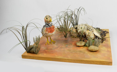
Artwork, other - Paper Taxidermy, Mary-Jane Walker, Plains Wanderer, 2020
The world’s most ecologically distinct bird lives in the native grasslands of Victoria - but only just. The plains-wanderer is a small bird that was once widespread across the grasslands of south-eastern Australia. Today there are fewer than 1000 mature birds in the wild. The plains-wanderer is under threat due to habitat loss caused by overgrazing, cropping and suburban sprawl. Unlike most other birds, female wanderers are larger and more colourful and the males take care of the chicks. They are only about 15cm tall and weigh between 40-80g for the male and 55-90g for the female. Their intricate plumage mirrors the colours of their grassland home so they blend in perfectly with their surroundings. The plains-wanderer’s origins date back to when Australia was part of the Gondwana supercontinent over 60 million years ago. They are so biologically distinct that their extinction would result in the loss of a branch of the tree of life. A fussy grass dweller, they like neither too much nor too little grass. That is where sheep grazing can help. After years of low numbers in Victoria, plains-wanderer populations have been increasing in Terrick Terrick National Park in north west Victoria, as sheep grazing maintains the grass in the park at a suitable level. With the right management, this ecologically important bird species is continuing to survive in the native grasslands of Victoria. Managing these habitats for the plains-wanderer can also support the conservation of many other threatened plant and animal species. Object: Nest of plains-wanderers by Mary-Jane Walker, 2020. Outer made from upcycled paper, internal structure steel. Nest of plains-wanderers by Mary-Jane Walker, 2020. Outer made from up cycled paper, internal structure steel. native grasslands, plains-wanderer, terrick terrick national park -
 Kew Historical Society Inc
Photograph - Yarra Street, Kew, Ron Setford, 1960
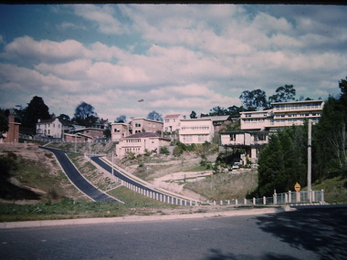
Ron Setford and his wife Grace Setford lived in Tanner Avenue, East Kew, from c.1946 to c.1995. A keen photographer, he recorded the changing face of Kew over a 20 year period. Apart from 30 photographs of built structures and places in Kew dating from 1960 and 1961, 145 of his 35mm colour slides chronicle the development of the Eastern Freeway through the Yarra Valley over a five year period from c.1972 to c.1977. This important collection was donated to the Society by his granddaughter in 2025.This collection of 175 35mm slides is of local and statewide significance, owing to its subject matter, particularly the major development of road transport infrastructure during the 1970s with the construction of the Eastern Freeway. The photographer also took care to annotate and date most of his slides which enable the researcher to pinpoint temporal and spatial locations.Yarra Street was not made a trafficable thoroughfare until October 1956. Until then, the gully was used as a dump, a shortcut to the river, and for communal Guy Fawkes night bonfires. The open landscape in the photo reflects near-total clearing by the original estate owners for grazing livestock. Post-war homes fronting Stawell St dot the landscape. Of particular note are the Broons House (c.1952–54) by Anatol Kagan (top right), and the homes of two architects, Kurt Elsner (c.1950) (middle) and Geoffrey Danne (c.1954) (lower right). Dual carriageways made blocks accessible, but building was difficult due to steeply sloping land and complex drainage easements. Nevertheless, these challenges resulted in highly innovative designs, making Yarra Street the core of the Yarra Boulevard Heritage Precinct."Yarra St Kew"ron setford, photographs -- kew (vic.) -- 1960s, yarra street -- kew (vic.) -
 Warrnambool and District Historical Society Inc.
Booklet with Photographs, Stan Baulch, Cowabee, 1978 (booklet)
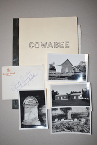
These items concern the history of the Baulch family ownership of Cowabee, a large grazing property in the Riverina in N.S.W. In the 1870s Samuel Baulch, the son of pioneer Kirkstall settlers, Francis and Ann Baulch, established a property in the Macarthur/Hawkesdale area called Rose Park. In 1893 he acquired Dunmore, a nearby property, and Rose Park became part of that estate. In 1910 Samuel Baulch purchased Cowabee in N.S.W. and Stan Baulch, the son of Samuel and Eliza, later managed Cowabee for some years. After Samuel’s death Stan Baulch and his two brothers split up Dunmore and Stan acquired the eastern third which he named Rose Park. Cowabee was sold in 1922. This booklet and associated material is of some historical interest as a summary of the history of Cowabee, one of the properties owned by the Baulch family of the Western District in the early 20th century. It will be of some use to researchers, with the photographs an added bonus. .1 This is a booklet of 41 pages with a buff-coloured paper cover with a black tape binding. The front cover has a title in hand-printed lettering and the back cover has a red stamp (partly obliterated). The booklet contains typed information on Cowabee Station. .2 This is a small envelope containing six black and white photographs, all with handwritten information on the back. .21 & .22 These are two loose sheets of writing pad paper with handwriting in blue ink. .1 Cowabee .2 Snaps Cowabee Church Cemetry(sic) & pise buildings left there cowabee station, n.s.w., baulch family western district victoria, history of warrnambool -
 Eltham District Historical Society Inc
Journal, Peter Doughtery, ArtStreams: News in arts and cultural heritage; Vol. 3, No. 1, Feb-Mar 1998 Month of Festivals Supplement, 1998
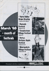
Vol. 3, No. 1, Feb-Mar 1998 Month of Festivals Supplement CONTENTS Yarra Valley Grape Grazing February 28 & March 1; Banyule Festival March 13-22; Templestowe Village Festival March 15; Pettys Antique Apple Festival March 21 & 22; Warrandyte Village Festival March 28 & 29 BANYULE FESTIVAL Festival full of fireworks 11 Poetry in motion at Montsalvat 12 TEMPLESTOWE VILLAGE FESTIVAL Festival takes you on a journey round the world 14 WARRANDYTE VILLAGE FESTIVAL Down by the riverside … 16 PETTYS ANTIQUE APPLE FESTIVAL 18 POETRY 20 A SENSE OF PLACE Exhibition of banners depicting a lifestyle 23 "Peter Dougherty has been involved in the local art scene for many years. As publisher and editor of the arts magazine Artstreams, his comments on the various branches of the arts are widely respected. His "The Arts" column in the Diamond Valley Leader presents a brief summary for a much wider cross section of the local community. Peter also operates his own gallery and the Artstreams Cafe at the St Andrews market. Peter has a wealth of knowledge about present day and historical aspects of local art and artists." - Eltham District Historical Society Newsletter No. 161, March 2005Colour front and back cover with feature articles and literary pieces with photographs and advertisements printed in black and white. 36 pages, 30 cm. Vol. 1, no. 1 (Nov. 1996) - Vol. 10, no. 5 (summer ed. 2005/06) art streams, banyule festival, ward sagar, arts on burgundy, montsalvat, were street cafe, rosanna fire station community house, bibby's bahnhof cafe, templestowe village festival, the pool and spa care centre, templestowe hotel, la piazza restaurant bar & cafe, recherche bespoke framers, margaret roadknight, mezze restaurant warrandyte, wintyre recital gallery, rivergum gallery warrandyre, food for all seasons, potters cottage, warrandyte festival, pettys orchard antique apple festival, fleur de feliss florist, allwood neighbourhood house, ray liversidge, llobex image wizards, victorian artists supplies, ian mcbryde, dynamic vegies, jackie wilson, boroondara litfest, mia mia gallery, eltham banners -
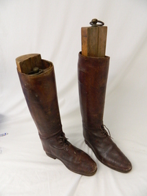 Kiewa Valley Historical Society
Boots Riding, late 1800's - early 1900's
The early Kiewa Valley farmers opened up the Bogong High Plains for cattle grazing in the late 1800's and early 1900's. Many farmers of the Kiewa Valley built huts on the Bogong High Plains to stay in during the summer mustering season. The Roper family had their own cattle run on the High Plains with several version's of Ropers Hut being built and used for this purpose. These boots were owned by Fred Roper whose father was one of the first pioneers of the Upper Kiewa Valley and Tawonga farming district. These boots were made around the late 1800's to early 1900's and are of a quality hide and a very good example of historical clothing worn at the time. These boots are very significant to the Kiewa Valley because the mark a period of early farming within the Kiewa Valley and Bogong High Plains as they were worn by Fred Roper who comes from one of the farming pioneering families of Tawonga. These boots were used when mustering the families cattle up to the Bogong High Plains for summer grazing and also around his farm in Tawonga when riding his horses. They were donated by his great grand daughter Leonie Roper in 2011, therefore the manufacturing of these boots could be anything from the late 1880's to early 1900's. They are made of high quality leather and were made to last the tough conditions of mustering and farming cattle. They also had wooden stock which fitted into them "KVHS 0445"These knee high "riding" boots have a 4 "rung" laces at the base of the upright boot and a strap at the top of the boot. They are made of brown leather and have a small heel (not the usual higher heel for stirrups)riding boots. footwear. cattle mustering footwear. roper family. cattlemen. bogong high plains. -
 Warrnambool and District Historical Society Inc.
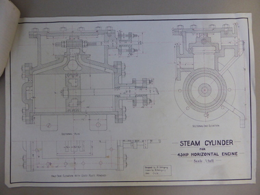
Document, Steam Cylinder Horizontal Engin, 1919
This drawing was produced by Ron Uebergang in 1919 at the Warrnambool Technical School. Members of the Uebergang families have been in the Warrnambool/Allansford area since the early 1850s. Ronald Uebergang (1903-1971) was born in Warrnambool, the son of Ernest Uebergang and Mary Watson. He lived at the family property, Hopkins Hill, and went to Allansford State School and Warrnambool Technical School. He was mechanically-minded, fond of music and dancing and a keen photographer. He married Myra Hall and they ran a dairy farm at Hopkins Hill and later went in for grazing beef cattle. Warrnambool Technical School was established in 1913, firstly at a Timor Street site and later at Caramut Road. Today it is called Brauer College. This drawing is of considerable interest as it was produced by Ron Uebergang. Members of the Uebergang families have been prominent in the Warrnambool/Allansford area since the early days of the district’s establishment. It is also important as a good example of the type of work produced by students from Warrnambool Technical School in its early years. This is a1919 drawing of a Steam Cylinder for a 45 HP Horizontal Engine. The drawing is half the full size of the cylinder. The drawing is on a white card with the sketches done in black and red ink. The card has a heavy black margin around the edges drawn in black ink. The drawing shows a Sectional Plan and a Half Side Elevation with the Cover Plate Removed. The card has the signature of Ron Uebergang. Attached by a metal clip to the card are four pages of measurements and plans of the steam cylinder. These are in black and red ink. Three of these pages have become partly detached. ‘Designed by R. Uebergang’ ‘Drawn by R. Uebergang’ ‘Date 1/12/19’ ronald uebergang, warrnambool technical school, history of allansford, history of warrnambool -
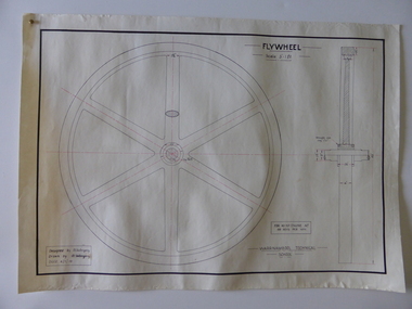 Warrnambool and District Historical Society Inc.
Drawing, Warrnambool Tech .1 Fly Wheel.2 Bevel Wheels R Uebergang, 1919
These drawings have been produced by Ron Uebergang at the Warrnambool Technical School in 1919. Uebergang family members were pioneer settlers in the Warrnambool area in the early 1850s. Ronald John Uebergang (1903-1971) was born in Warrnambool to Ernest Uebergang and Mary Watson. Ron Uebergang lived at the family property, Hopkins Hill at Allansford and went to Allansford State School and Warrnambool Technical School. He was mechanically minded, a good photographer and fond of music and dancing. He married Myra Hall and was a dairy farmer at Hopkins Hill and later grazed beef cattle. Warrnambool Technical School was established in 1913, firstly at a Timor Street site and later at Caramut Road (today it is known as Brauer College). These drawing are of considerable interest as works produced by Ron Uebergang. Uebergang family members have been prominent in the Warrnambool-Allansford area since the pioneering days of the district. The drawings also are good examples of the type of work produced by Warrnambool Technical School students in its early years.These are two designs and drawings by Ron Uebergang produced at the Warrnambool Technical School in 1919. They are drawn on white card using black and red ink. The scale of the Flywheel is three inches to one foot and the Bevel Wheels are one-third full size. The drawings are edged with heavy black lines. The two sheets have the signature of Ron Uebergang. There are also four pages of handwritten notes on the Flywheel and Bevel Wheels.‘Designed by R. Uebergang’ ‘Drawn by R.Uebergang’ ‘Date 4/1/19’ (on Flywheel sheet) ‘Date 27/5/19’ (on Bevel Wheels sheet) warrnambool technical school, ronald uebergang, history of allansford -
 Surrey Hills Historical Society Collection
Photograph, Streetscape near the corner of Victoria Crescent and Hotham Street, Surrey Hills
Prior to subdivision for housing this area was paddocks used for grazing of cattle and used as part of the course in the early days of the Surrey Hills Golf Club. Reproduced by permission of Mr John Arnold from his book: "The Riversdale Golf Club - a history, 1892-1977." Copyright to book: Riversdale Golf Club. Surrey Hills Golf Club operated from 1892-1908 then moved and became Riversdale Golf Club. The game was played across paddocks from Trafalgar Street, Mont Albert to Whitehorse Road and down Victoria Crescent to where Box Hill TAFE is now located in Elgar Road. There were problems with cows eating the tee flags! The clubhouse still exists as 30 Trafalgar Street.Black and white photo taken from the centre of a bitumen road which is flanked by bluestone guttering. Nature strips, drive cross-overs and house fences are shown. Trees on the RHS nature strip are pollarded to avoid overhead power and telephone lines. There houses in the background."Bottom: The same view today taken from the intersection of Victoria Crescent and Hotham Street, Surrey Hills."surrey hills golf club, hotham street, victoria crescent, riversdale golf club, surrey hills, john arnold -
 Sunbury Family History and Heritage Society Inc.
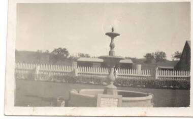
Photograph, Emu Bottom
The fountain in the image is at the entrance to the 'Emu Bottom' homestead. George Evans squatted on land to graze sheep, along the Jacksons Creek Valley, originally known as Buttlejork Valley, in 1836 and built the homestead from local Silurian sandstone and timber. Over the years it has had a number of owners. In the 1920s the property was renamed 'Holly Green' by H.L Webb after a property in Narre Warren.In the 1950s it was renamed 'Emu Bottom'. Over the years a number of fires have destroyed parts of the building and as a result, little of the original building remains. The fountain was erected in 1936 to mark the centenary of the property as well as 100 years of European settlement in theSunbury area. The property is now a private residence and function centre.'Emu Bottom' is one of the oldest homesteads in Victoria.A small non-digital sepia photograph with a cream border of a fountain, with a horse trough around the base, at the entrance of a rural property.'emu bottom', holly green, sunbury, jacksons creek, buttlejork valley, george evans -
 Warrnambool and District Historical Society Inc.
Documents, Technical Drawings Feed Pump
These drawings have been produced in 1919 by Ron Uebergang when he was a pupil at the Warrnambool Technical School. The Uebergang families were pioneers in the Warrnambool/Allansford area. Ronald Uebergang (1903-1971) was born in Warrnambool to Ernest Uebergang and Mary Watson. He went to Allansford State School and Warrnambool Technical School and married Myra Hall. He was mechanically-minded, a good photographer and fond of music and dancing. He and Myra had a dairy farm at the family property, Hopkins Hill near Allansford and later took up grazing beef cattle. Warrnambool Technical School was established in 1913, and was located first on a Timor Street site and later moved to Caramut Road. Today it is called Brauer College. These drawings are of considerable interest because they were produced by Ron Uebergang and the Uebergang families have been prominent in the history of the Warrnambool and Allansford areas since the 1850s. They are also of interest as examples of the type of work produced by students of Warrnambool Technical School in its early days. .1 A Blueprint for a Feed Pump for a Horizontal Engine - blue background, white drawings. The drawing is two-thirds of the full size object. .2 The same drawing on white see-through paper. The paper has a thick line drawn around the edges in black ink. .3 The same drawing on plain white card with drawings in black ink and a thick line drawn around the edges in black ink. .4 The original brown paper covering used to send the drawings to Warrnambool Technical School in 1921. There are also two pages of handwritten material attached to the drawings by a metal clip and giving a description of the design of the Feed Pump. ‘Warrnambool Technical School’ ‘Designed by R. Uebergang’ ‘Drawn by R. Uebergang’ ‘Date 7/10/19’ ronald uebergang, warrnambool technical school, history of allansford, history of warrnambool -
 Bendigo Historical Society Inc.
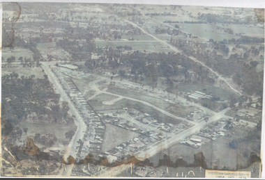
Photograph - Aerial View Sydenham Gardens Estate Circa 1972
The Sydenham gardens were set up in 1854 to provide an area of relaxation for diggers. A German, Mr Kraemer, made extensive plantings of ornamentals and fruit trees. The area expanded to 11 acres in 1865 and 25 acres in 1916. T O Hunter owned the gardens from about 1896 and initially it was used for many types of entertainment including, picnics, festivals and sporting events. It was situated off Holdsworth Road in what is now Jackass Flat. T O Hunter was a cordial manufacturer in Macrae Street, who was prominent in many sporting areas. He was President of the Bendigo Coursing Association and raced both dogs and horses. By the time he sold the gardens in 1936 to Mr Muir, he was using the gardens as grazing for his horses.Photograph: aerial view of Sydenham Gardens Estate Circa 1972 , as noted on photo Colour photo, A5 sizephoto sydenham gardens estate, aerial photo -
 Ballarat Heritage Services
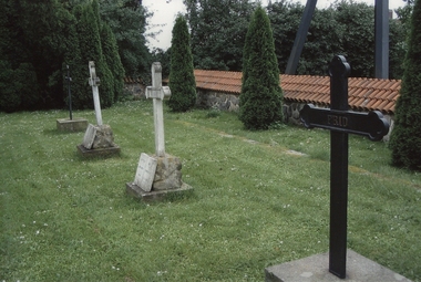
Digital photograph, Denise Kinnane, Graves, Robelofs church, 2007
These graves are situated at a small medieval church that is a popular baptismal and wedding church. It is part of the Råbelöv estate in Kristianstad Municipality, Scania, in southern Sweden. They are the graves of Douglas and his brother. In 1906, the eldest son of James Kennedy, Douglas Kennedy, the future fidei commissioner, took his life. Four years later another son took his life. James and his wife took the disasters hard, they fell ill. The young son Gilbert got in 1908, only 22 years old, took over responsibility for the farm. James son Gilbert Kennedy took over as Fidei Commissioner in 1916 and they became known as outstanding farmers with, among other things, grazing for dairy cows and fruit growing as specialties. Digital photographkristianstadt, kennedy, sweden, råbelöv, church, castle, graves, douglas kennedy -
 Surrey Hills Historical Society Collection
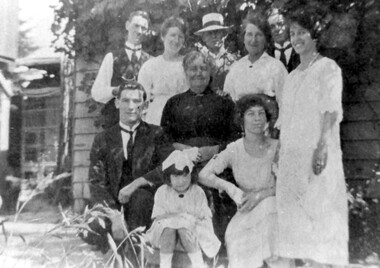
Photograph, Kleinert family gathered fro Christmas celebrations at 34 Union Road, Surrey Hills
William was a coach-builder, wheelwright and blacksmith. He moved from Prahran to Surrey Hills to property owned by the family. The house at 34 Union Road was built in 1905 for William and his wife Emily. Their son Ernest worked with him as a coach painter and also worked as a painter undertaking intricate hand painting on early cars. Their other son Martin played for the Surrey Hills Football Club. In return for the support given to the club by Mrs Emily Kleinert, the club built a rotunda in South Surrey Park as a memorial to her. Alan Holt research: Lot 6 was sold to Martin Kleinert by Karl Richter in 1860 together with a portion of another adjacent lot. From 1860-1885 Martin worked it as a market garden leasing some land for grazing when it was not required for gardening. He died in 1898. In a formal document, William declared he was the son of Martin "who purchased land in 1860, died in 1898 and the land has been continually occupied by father and family since. It has been cultivated as a market garden; when not being used for gardening it was let for cultivation and grazing." William died in 1939 and the property passed to his sons Martin and Ernest. The Kleinert land extended from Union Road to Essex Road. They ran horses, ducks and fowls and Emily Kleinert grew flowers. The Kleinert property later became the South Surrey Park. The family sold the land to the Camberwell Council in the 1950s. Ernest and Ida Kleinert lived on the corner of Scotsdale and Warrigal Roads. The donor of the photo Nada Harris, nee Kleinert, was Ernest and Ida's daughter. Ida lived to a good age (> 93 years) and in later life lived in Burwood.Black and white photo of a large group of men, women and children posed for the photograph which is taken outdoors. William Kleinert is identified as seated in the front centre playing his German melodion. Sons Ernest and Martin and William's daughters Ivy and Rose are also in the photo (not identified). Nada Kleinert (daughter of Ernest and Ida and 1st grand-daughter of William and Emily) is standing next to her great-grandmother Radford.surrey hills football club, blacksmiths, wheelwrights, coachbuilders, south surrey park, rotunda, miss ida kleinert, emily kleinert, mr william kleinert, miss ivy kleinert, miss rose kleinert, mr ernest kleinert, miss nada kleinert, mrs nada harris, mr martin kleinert -
 Bendigo Historical Society Inc.
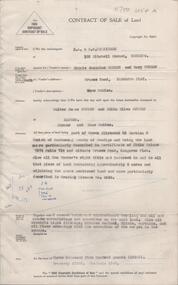
Document - H. A. & S. R. WILKINSON COLLECTION: CONTRACT OF SALE
Contract of sale of land dated 29th April, 1957 between Miss M. J Schier & Mrs. M. Turner (vendor) and Mr. W. J. & Mrs. E. O. Sutton (purchaser). Property: land being part of Crown allotment 23 section G Parish of Mandurang county of Bendigo, land described in certificate of title volume 7374 folio 714 and situated Crusoe Road, Kangaroo Flat. Also all vendor's right title and interest in to that piece of land containing approx. 6 acres and adjoining the above mentioned land described in grazing licence no. 0349. Together with 6 roomed brick and weatherboard dwelling, all sundry outbuildings, electric light fittings, kitchen cabinet, blinds, curtains and floor coverings with exception of the carpet in the lounge. Price: 3,500 pounds. Attached Statement pursuant to section 34 of the estate agents' act 1956.organization, business, h.a. & s.r wilkinson real estate -
 Kew Historical Society Inc
Photograph, J F C Farquhar, Studley Park Road, 1891
At the beginning of the 1890s, the Kew businessman and Town Councillor, Henry Kellett, commissioned J.F.C. Farquhar to photograph scenes of Kew. These scenes included panoramas as well as pastoral scenes. The resulting set of twelve photographs was assembled in an album, Kew Where We Live, from which customers could select images for purchase.The preamble to the album describes that the photographs used the ‘argentic bromide’ process, now more commonly known as the gelatine silver process. This form of dry plate photography allowed for the negatives to be kept for weeks before processing, hence its value in landscape photography. The resulting images were considered to be finely grained and everlasting. Evidence of the success of Henry Kellett’s venture can be seen today, in that some of the photographs are held in national collections.It is believed that the Kew Historical Society’s copy of the Kellett album is unique and that the photographs in the book were the first copies taken from the original plates. It is the first and most important series of images produced about Kew. The individual images have proved essential in identifying buildings and places of heritage value in the district.In this view of Studley Park Road, looking northeast to the Junction, the photographer invites the viewer to participate in a point-of-view that emphasises the elevated, tranquil vantage point of the hill in contrast to the bustling commercial area in the distance. The view emphasises the exclusiveness of Studley Park, with its high fences behind which a number of significant Kew mansions were concealed. Contemporary advertisements for the sale of mansions in Studley Park Road often included fulsome descriptions of their elaborate formal gardens, as well as paddocks for grazing, stabling and dairies. None can be seen here. The use of high, protective wooden pickets to surround the newly planted avenue of elms on the south side of the road appears to be typical of the period. Similar examples can be seen in early photographs of Wellington and Princess Streets.The horse and carriage, selected as a central focus of the view, reinforces the residential, exclusive nature of this part of Kew in the early 1890s. Studley Park Roadkew illustrated, kew where we live, photographic books, henry kellett -
 Warrnambool and District Historical Society Inc.
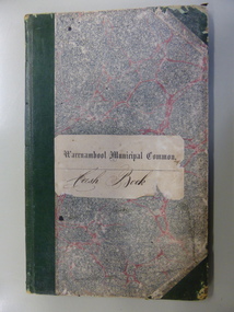
Ledger, Warrnambool Municipal Common, Circa 1865
This cash book contains entries which relate to the everyday operation of the Borough Common which predates the establishment of Warrnambool as a town. All ratepayers had the right to graze their cows on the common, with the cows being collected every morning by the herdsman and walked to the common. Entries relate to items such as eradication of thistles, repairs and erection of stock yards, burying of dead stock, purchase of bulls and clearing of waterholes. Salaries were paid to E. Margetts, D Allan, T Raingill, and M T Read. Auditors were James Dickson. After WW1 parts of the common were allocated to soldiers’ settlement blocks ranging from 18 to 30 acres. Other parts remained with the Crown for Municipal uses and part became the Warrnambool Golf Course. In 1925 the common was abolished.The entries in this book record the operations and earliest residents who were involved in the Common in the early days of WarrnamboolGrey and red mottled card cover with dark green points and spine. Paper label on front cover. Dark blue and tan mottled paper inside front and back covers. Warrnambool Municipal Common Cash Book.warrnambool borough, warrnambool common, e margetts, raingill, d allan, m t read, warrnambool common cash book -
 Kiewa Valley Historical Society
Photographs – Skiers at Falls Creek – Set of 10 black and white photographs
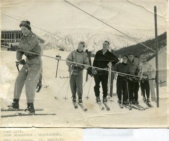
After World War II, the Kiewa Hydro-Electric Scheme was started in the Kiewa River valley by the State Electricity Commission of Victoria. On land previously used only for summer cattle grazing in the natural alpine grasslands, the first ski lodge was built in 1948 by workers from the hydro scheme as skiing was a popular recreation. Many of the hydro employees were of European background and had grown up enjoying skiing and snow sports in their homelands and were keen to continue to pursue their winter sports interests. The first lift, a rope tow, was built in 1951 and the first chairlift in Australia was constructed there in 1957. Two T-Bars were opened in 1961. In 1964, the Victorian Municipal Directory recorded that Falls Creek had 29 ski club lodges and 16 commercial lodges.Employees of the State Electricity Commission of Victoria in the Kiewa River Valley were the earliest skiers on the Bogong High Plains and built one of the first ski lodges at Falls Creek. They were amongst those pivotal in the development of the skiing and tourist industry at Falls Creek and on the Bogong High Plains. Set of 10 black and white photographs of various skiers at Falls Creek Victoria1. From Left-John Robertson Myrtleford; Bill Bridgford, St Trinians; Girl not known; Roy Wolpole, Myrtleford; Fin McAuliffe, Myrtleford; Looking on foreground, Toni St Elmo 2. Falls Creek. Property of State Electricity Commission of Victoria Publicity Photo Negative No PB4046. Publicity Branch, 15 William St Melbourne. 3. Avic Lajons 4. No markings 5. Bill Bridgeford (lower person on slope) 6. Max Lawrence? Facing skiers 7. 6575. Indistinguishable red stamp on back 8. 6875. Ces Dobson on tractor 9. From left on tow. John Robertson (Myrtleford); Bill Bridgeford (St Trinians); Girl unknown; Roy Walpole (Myrtleford); Vin McAuliffe (Myrtleford); Looking on foreground Toni Beveridge. 10. From Left 1; 2; 3. Bill Bridgeford; 4. George McPherson ? (Myrtleford); 5. John Robertson (Myrtleford); 6. Elsbeth Rollenson? (Myrtleford); 7; 8; 9. 11. Bogong. Looking N.E from Big River fire track. Skiers on way to Falls Creek. Spion Kop on left. Going around Ropers Cerner near the 18 mile post falls creek, skiing, bogong high plains -
Eltham District Historical Society Inc
Folder, Simon Armstrong, 1868
Simon Armstrong Armstrong, Simon, Kangaroo Ground, is a native of Scotland, born in 1822. In October 1839 he came to Melbourne where he remained for one year, after which he went to Essendon, and stayed there until 1867, when he went to Kangaroo Ground, and established himself as a farmer on partially improved land purchased from Mr Thomas Armstrong; and he also possesses 160 acres at Yarra Flats, which he uses for grazing purposes. Mr Armstrong was married in 1854, and has a family of two sons and five daughters. from "Victoria and its Metropolis: Past and Present" written in 1888 by Alexander Sutherland. Chapter 19, "The Upper Yarra District" pages [402] - 415. Includes descriptions of some townships and short biographies of local residents. Page 405 Folder of information on Simon Armstrong, Kangaroo Ground, 1868simon armstrong -
 Eltham District Historical Society Inc
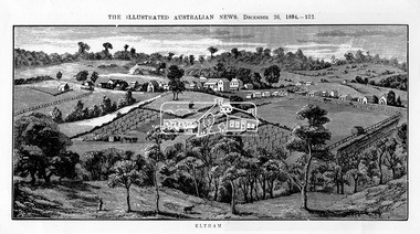
Photograph, Samuel Calvert, Eltham, The Illustrated Australian News, December 26, 1884, p212, 1884
A description in the newspaper near the illustration (page 210) reads as follows: "Eltham is a pretty little township on the Yarra Flats road, about 14 miles east north east of Melbourne, from which place there is communication by way of Heidelberg. It has a population of nearly 400 inhabitants, but in addition it is the centre of a large district extending over about 203 square miles, having a population of 2344. The land in the district is mostly used for grazing purposes, although as a rule the small farms grow a good deal of wheat, oats and other agricultural produce. A large quantity of fruit, especially raspberries and strawberries, is also produced, the rich alluvial flats along the creek upon which the township is situated being very well adapted for that purpose. Gold has also been found in the vicinity of the township, but not in remunerative quantities". This photo forms part of a collection of photographs gathered by the Shire of Eltham for their centenary project book,"Pioneers and Painters: 100 years of the Shire of Eltham" by Alan Marshall (1971). The collection of over 500 images is held in partnership between Eltham District Historical Society and Yarra Plenty Regional Library (Eltham Library) and is now formally known as 'The Shire of Eltham Pioneers Photograph Collection.' It is significant in being the first community sourced collection representing the places and people of the Shire's first one hundred years.Digital imageshire of eltham pioneers photograph collection, eltham, illustrated australian news -
 Surrey Hills Historical Society Collection
Photograph, Kleinert family at 34 Union Road, Surrey Hills
William Kleinert (Friedrich John Wilhem Kleinert) made wine from the grapes he grew. The house was built in 1905 and was the home of William and Emily Kleinert from 1905. William was a coach-builder, wheelwright and blacksmith. He moved from Prahran to Surrey Hills. His son Ernest worked with him as a coach painter and also worked as a painter undertaking intricate hand painting on early cars. Their other son Martin played for the Surrey Hills Football Club. In return for the support given to the club by Mrs Emily Kleinert, it built a rotunda in South Surrey Park as a memorial to her. Alan Holt research: Lot 6 was sold to Martin Klienert by Karl Richter in 1860 together with a portion of another adjacent lot. From 1860-1885 Martin worked it as a market garden leasing some land for grazing when it was not required for gardening. He died in 1898. In a formal document, William declared he was the son of Martin "who purchased land in 1860, died in 1898 and the land has been continually occupied by father and family since. It has been cultivated as a market garden; when not being used for gardening it was let for cultivation and grazing." William died in 1939 and the property passed to his sons Martin and Ernest. The Kleinert land extended from Union Road to Essex Road. They ran horses, ducks and fowls and Emily Kleinert grew flowers. The Kleinert property later became the South Surrey Park. The family sold the land to the Camberwell Council in the 1950s. Ernest and Ida Kleinert lived on the corner of Scotsdale and Warrigal Roads. The donor of the photo Nada Harris, nee Kleinert, was Ernest and Ida's daughter. Ida lived to a good age (> 93 years) and in later life lived in Burwood.Black and white photo of a group of men and women posed against the backdrop of a timber house. Immediately behind the group is a large grape vine and drying racks can be seen to the left of the picture. The group is identified as: Standing L to R: Ernest Kleinert, Rose Kleinert, William and Emily Kleinert, ? (unidentified), Ida Kleinert (nee de Vasey) Seated (L to R): Martin Kleinert, Nada Kleinert (daughter of Ernest and Ida and 1st grand-daughter of William and Emily), great-grandmother Maria Radford, Ivy Kleinert.surrey hills football club, blacksmiths, wheelwrights, coachbuilders, harris, rotunda, william kleinert, vineyard, ernest kleinert, rose kleinert, ida kleinert (mrs), ida de vasey (miss), martin kleinert, nada kleinert (miss), ivy kleinert (miss), friedrich john wilhem kleinert, emily florence radford (miss), maria dina radford (mrs), maria dina aylwin (miss) -
 Kiewa Valley Historical Society
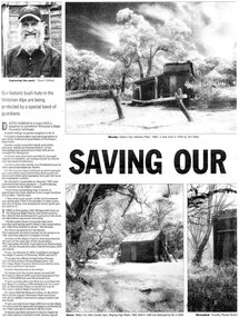
Newspaper article- Double page article. Pages 30 & 83 from the Herald Sun Newspaper. February 18, 2006 regarding preserving Victoria’s High Country Huts
The arrival of explorers Hume & Hovell in 1842 brought about the widespread clearing of land in the valleys for pastoral uses and the displacement the original inhabitants in the high country which became a boon for cattlemen due to extensive lush summer grazing for cattle. High country cattlemen built a variety of huts for shelter and storage, when driving cattle up to the plains in summer, during mustering and bringing the cattle down from the mountains before winter closed in. These same huts now provide shelter from the elements for hikers, bush walkers and skiers. Wallace’s Hut is the oldest of the Cattleman’s huts still standing in the Alpine National Park and is classified under the National Trust. Due to their age and the ravages of the elements, including bush fires, many of the huts have been destroyed, or are falling into disrepair. Groups of willing volunteers are now working to preserve as many of the huts as possible with restoration or rebuilding.The numerous cattleman’s huts of the Alpine National Park and the colourful characters who erected them represent a significant part of the history of the high country area and early cattle grazing, which has been the theme for many poets and film-makers alike. They also have a significant role in the early days of the SECV when they were used by surveyors and other workers for shelter and temporary accommodation. More recently the huts have functioned as shelter for hikers and skiers caught out in the elements and a refuge along the long trek for bush walkers. They are a popular attraction for tourists and feature prominently in much of the tourist information of the region. Black and white double page Newspaper article from the Herald Sun Newspaper of February 18, 2006 regarding the efforts of Mr David Oldfield to preserve Victoria’s remaining High Country Huts through his photography and efforts to restore old and Re-build missing ones. Article shows a photograph of David Oldfield and some of his photographic work of the huts. Page number and date printed at top of each page 30 Herald Sun, Saturday, February 18, 2006 Herald Sun, Saturday, February 18, 2006 83 cattlemen's huts; david oldfield; bogong high plains; wallace's hut; high country; alpine national park -
 Kiewa Valley Historical Society
Photographs –Collection of 10 copies and original black and white photographs and printed articles relating to skiing on the Bogong High Plains
After World War II, the Kiewa Hydro-Electric Scheme was started in the Kiewa River Valley by the State Electricity Commission of Victoria. On land previously used only for summer cattle grazing in the natural alpine grasslands, the first ski lodge was built in 1948 by workers from the hydro scheme as skiing was a popular recreation. Many of the hydro employees were of European background and had grown up enjoying skiing and snow sports in their homelands and were keen to continue to pursue their winter sports interests. The first lift, a rope tow, was built in 1951 at Falls Creek and the first chairlift in Australia was constructed there in 1957. Two T-Bars were opened in 1961. In 1964, the Victorian Municipal Directory recorded that Falls Creek had 29 ski club lodges and 16 commercial lodges. The area became a popular tourist destination for both winter and summer sports.: Employees of the State Electricity Commission of Victoria in the Kiewa River Valley were the earliest skiers on the Bogong High Plains and built one of the first ski lodges at Falls Creek. They were amongst those pivotal in the development of the skiing and tourist industry at Falls Creek and on the Bogong High Plains. Collection of 10 copies and original black and white photographs and printed articles relating to skiing on the Bogong High Plains. Some pieces have been enlarged to A3 poster size copies for display purposes 1. Copy of black and white photograph of group of skiers at Falls Creek 2. Copy of photograph of early skier on Bogong High Plains with temporary buildings and tents in the background 3. Copy of photograph of 3 skiers on Mt McKay 4. Copy of SECV photograph of Rocky Valley Camp under snow 5. Early sepia photograph of Falls Creek village with skiers in the foreground 6. Copy of a page from booklet (SECV?) promoting the benefits of owning a holiday home in the Bogong Village area 7. Copy of a page from booklet (SECV?) promoting the benefits of holidaying in and around Falls Creek/Mt Beauty 8. Panoramic view of ski fields with skis in the foreground 9. Photograph of young skier (identity unknown) 10. Photograph of 2 male skiers (identity unknown) performing a small jump 1. Bogong Ski Club Members & Friends 1944 2. Jack Neve – electrician. Rocky Valley 3. 17.5.55 Skiers ascending Mt McKay 4. State Electricity Commission of Victoria. Date:17.8.55 No:K8132 Kiewa Hydro Electric Works. Rocky Valley Camp – From Engineering Office 5 & 9 No markings 6 & 7 Short article relating to photos on each page 8. Handwritten signature on rear of photo (Sandra Conea) 10 Faded unreadable photographers stamp and handwritten numbers 6875 on rear secv; bogong high plains; skiers; falls creek; tourism -
 Kiewa Valley Historical Society
Photographs – Bogong High Plains - Set of 16 black and white photographs mounted back and front on 3 pieces of heavy black card likely removed from a photograph album
After World War II, the Kiewa Hydro-Electric Scheme was started in the Kiewa River Valley by the State Electricity Commission of Victoria. On land previously used only for summer cattle grazing in the natural alpine grasslands, the first ski lodge was built in 1948 by workers from the hydro scheme as skiing was a popular recreation. Many of the hydro employees were of European background and had grown up enjoying skiing and snow sports in their homelands and were keen to continue to pursue their winter sports interests. The first lift, a rope tow, was built at Falls Creek in 1951 and the first chairlift in Australia was constructed there in 1957. Two T-Bars were opened in 1961. In 1964, the Victorian Municipal Directory recorded that Falls Creek had 29 ski club lodges and 16 commercial lodges. The area became a popular tourist destination for both winter and summer sports.Employees of the State Electricity Commission of Victoria in the Kiewa River Valley were the earliest skiers on the Bogong High Plains and built one of the first ski lodges at Falls Creek. They were amongst those pivotal in the development of the skiing and tourist industry at Falls Creek and on the Bogong High Plains. Black and white photographs of varying sizes mounted decoratively on heavy black Card. Some pages display a brief description printed in white ink 1. 4 photographs- displayed diagonally across page. 2 pictures of a group of men standing in the snow in front of a car with a loaded trailer behind. 1 photo of skiers. 1 photo of show hanging in tree branches. 2. 2 photographs- showing Upper Kiewa Road with snow in the background 3. 3 photographs- of skiers and 1 photo of 2 of men posing in the snow & 1 photo of 2 men posing shirtless in warmer weather. 4. 2 photographs- arranged diagonally on page showing early buildings and construction at Bogong Village 5. 2 photographs- 1 showing view of Bogong Village from higher up the mountain. 1 showing early Bogong High Plains road 6. 1 photograph- showing view down along Kiewa Valley from higher up in the mountains 1. Handwritten in white ink – A TRIP TO THE PLAINS 2. Handwritten in white ink – UPPER KIEWA ROAD MT FAINTER IN BACKGROUND 3 – 6. No markings bogong village; upper kiewa road; bogong high plains; falls creek; skiers -
 Eltham District Historical Society Inc
Journal, Peter Doughtery, ArtStreams: News in arts and cultural heritage; Vol. 2, No. 1, Feb-Mar 1997, 1997
Vol. 2, No. 1, Feb-Mar 1997 CONTENTS MEDALS AND MODERNISM A retrospective look at the cultural impact of the Melbourne Olympics 3 CD REVIEWS 6 NEW HORIZONS Judy Jacques takes a new direction 6 LA MAMA 30 YEARS ON Liz Jones at the helm 10 PAST AS POST CUBISM Annita Furey on Heather Shim men 14 GRAPE GRAZING FESTIVAL Food, wine and music in the Yarra Valley 16 SHORT STORY Fantasia on a cup of coffee 18 WHAT'S ON A round-up of events for February 22 WHO'S TEACHING WHAT Classes in the region 24 FRANCES DUFFY RETROSPECTIVE An artist who extended the boundaries of tonalism 26 ANDY WARHOL AND THE CAN OF SOUP More than 15 minutes of fame 27 A ‘DUTCH’ FESTIVAL COMES TO ST ANDREWS 28 LISTINGS Artists, performers and galleries 29 "Peter Dougherty has been involved in the local art scene for many years. As publisher and editor of the arts magazine Artstreams, his comments on the various branches of the arts are widely respected. His "The Arts" column in the Diamond Valley Leader presents a brief summary for a much wider cross section of the local community. Peter also operates his own gallery and the Artstreams Cafe at the St Andrews market. Peter has a wealth of knowledge about present day and historical aspects of local art and artists." - Eltham District Historical Society Newsletter No. 161, March 2005Colour front and back cover with feature articles and literary pieces with photographs and advertisements printed in black and white. 36 pages, 30 cm. Vol. 1, no. 1 (Nov. 1996) - Vol. 10, no. 5 (summer ed. 2005/06) 1956 melbourne olympics, 1956 olympics, 1995 eltham arts ball, a.d. (archie) colquoun, abu baku, adams of north riding, afandi siyo, albert namatjira, alice (1956), andy warhol, annita furey, anthony dymke, art streams magazine, ballarat school of mines, bathing in the dark, bob sedergren, bob valentine, bourbo's belly, brian brown quntet, bulleen art & garden centre, cafe margot, charles blackman, christine edwards, circushead, clifton pugh, cottlesbridge, council amalgamation, cuddlefish, dave pithouse, david lord, david tolley, dawn sime, dione mcintyre, dixon's creek, edward grigoryan, eltham college concert band, eltham wiregrass gallery, erika mcgilchrist, fergusson winery, food for all seasons, frances duffy, fred williams, frenzi, geoff achison, geoff mainwaring, graeme bell, grape grazing festival, half caste child, heather shimmen, hoodangers, isobel lindsay, james wakeling, janette geri, john brack, john mcall, john murphy, jordie albiston, judy jacques, kath mckinnon, katherine's silly women, kelly 1956, ken harrison, kevin borland, kim harriss quartet, la mama theatre, lauurie dawes, leonard french, lighthouse, liz jones, lloyd jones, lothlorien, lovegroves, lovey's estate, luxum, maelstrom, max meldrum, may grigg, michelle nicolle, mighty servant, mirka mora, miss suzannah espie, moma, montsalvat jazz festival, moonee valley drifters, moonlight shadow, museum of modern art at heide, mystery train, the melbourne jazz band, nicole eveleigh, nigel shipley, olympomania, peter mcintyre, phyllis murphy, pip avent, portrait of georges mora (1956), ray horsfield, red shed theatre company, reed's gallery, richardson house (1955), river house (1955), robin boyd, sandro donatti, secret of the west wind, seville, shantell vineyard, shedlevellers bush band, shirley bourne, sigmund jorgensen, sir william dargie, soul sister swing, sydney nolan, that handsome couple, the band who knew too much, the broken fence (1956), the gusset rustlers, the rhonda movement, the russian gypsey jazz quartet, three amigos, victorian artists supplies, warburton, wholefood delights, yarra valley grape grazing festival, yellow dog jazz band, yering station, art streams -
 Surrey Hills Historical Society Collection
Photograph, Stan Smith c1916, 1916
Stan Smith, then of 3 Vincent Street, on his father’s horse in Mont Albert Road in about 1916. Mr Charles Smith was an insurance officer whose area was from Burke to Elgar Road; he used his phaeton for transport. Oral testimony - Stan Smith: “We had a stable for the horse near the house and a yard but we tethered the horse at the end of a long rope on paddocks in Empress Road- the area from Mont Albert Road to Guildford Road. We used to put in an iron peg. Some horses were tethered similarly in various paddocks but not a lot of people had horses by this time. A few cows grazed around them.” The picket fence on the left and the trees were those of ‘Monserrat’ – the Parer home, now entered from 26a Wandsworth Road as the Mont Albert Road frontage was sold off many years ago. A black and white photograph of a young boy on a horse. There are a number of well established trees in the background and a fence. The young boy is identified on the back of the small photograph as "Stan" on "Bob" the horse.On back of small photograph: "Stan on Bob / Mont Albert Rd / Surrey Hills 1916 / In front of / Mr Parers home"(mr) stan smith, vincent street, surrey hills, empress road, wandsworth road, house names, parer home, (mr) charles smith, 'monserrat' -
 Kew Historical Society Inc
Photograph, J F C Farquhar, The Yarra in Hyde Park, 1891
At the beginning of the 1890s, the Kew businessman and Town Councillor, Henry Kellett, commissioned J.F.C. Farquhar to photograph scenes of Kew. These scenes included panoramas as well as pastoral scenes. The resulting set of twelve photographs was assembled in an album, Kew Where We Live, from which customers could select images for purchase.The preamble to the album describes that the photographs used the ‘argentic bromide’ process, now more commonly known as the gelatine silver process. This form of dry plate photography allowed for the negatives to be kept for weeks before processing, hence its value in landscape photography. The resulting images were considered to be finely grained and everlasting. Evidence of the success of Henry Kellett’s venture can be seen today, in that some of the photographs are held in national collections.It is believed that the Kew Historical Society’s copy of the Kellett album is unique and that the photographs in the book were the first copies taken from the original plates. It is the first and most important series of images produced about Kew. The individual images have proved essential in identifying buildings and places of heritage value in the district.Hyde Park is now a small recreation reserve bordered by Willsmere and Kilby Roads and White Avenue. In 1982, Hyde Park was cut off from the Yarra River by the construction of the Eastern Freeway. The building of the latter was to transform the natural landscape, including the Yarra, as well as Hyde Park. The construction of the Freeway makes it difficult to view the scene with the photographer’s eye. Today’s Hyde Park is located on land purchased in 1847 by John Cowell, and in 1851 Catherine Cowell, yet the scene selected by the photographer may well have been located on farmland owned by the Wills family. Farquhar’s point-of-view emphasises both the pastoral and recreational elements of the scene: the grazing cows, three boys, and in the distance two figures, seated on the bank with a parasol. By 1891, an environmental consequence of human activity, including farming, was deforestation, leading to the erosion of the south bank of the Yarra. In contrast, the land on the Alphington side of the river in 1891 included remnant bushland.The Yarra in Hyde Parkkew illustrated, kew where we live, photographic books, henry kellett, yarra river -
 Melton City Libraries
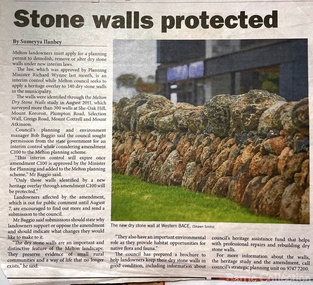
Newspaper, Stone Walls protected, 2015
Dry stone construction as a technique is used for much more than paddock walls. Across the volcanic plains of western Victoriaare marvelous sheep dips, stock loading ramps, huts, dams, retaining walls, and the rich and largely undiscovered heritage of indigenous dry stone structures. Dry stone walls indicate many aspects of our rural environment; the geological beginnings of the way the landscape was created, the patterns of early settlement by pastoralists and squatters, the types of stock that grazed the land and the methods of cattle and sheep management, of the efforts to thwart the spread of rabbits .... "For the casual but interested observer dry stone walls are good to look at, to photograph, to get up alongside and see the way they are constructed, to appreciate the varying shapes and sizes of stones and learn of the techniques of keeping often quite rounded stones in place. Apart from walls and other dry stone structures on grazing land we can also see dry stone techniques used in other places and in other phases of our history. Indigenous Australians have built, and continue to build, structures for shelter or hunting or trapping eels and fish in rivers and estuaries around the country. At spots around our coast line there is evidence of simple stone structures built by early maritime explorers. Prospectors in early mining encampments used dry stone construction to build retaining walls or the low walls of rudimentary shelters. If the future of dry stone walls in the Australian landscape is to be assured. wall owners and local governments have to accept and embrace their custodial role in assuring the preservation and celebration of walls. This is not an easy task, but, along with putting the necessary statutory mechanisms to ensure their retention, it is a task that must be pursued. The Dry Stone Walls Association of Australia has as its primary goal the increase in awareness of wall owners and local governments of the importance of dry stone walls. It also seeks to increase the level of training of skilled and semi skilled wallers, and the gaining of rudimentary skills by farmers so that they can maintain their own walls". Melton Star Weekly article about the Stone Wallslandscapes of significance -
Federation University Historical Collection
Booklet, Little Desert National Park and Wail State Forest Proposed Management Plan, 1991, 11/1991
... grazing ...Grey soft covered report of 80 pages. Includes a pull out map.little desert national park, wait state forest, management plan, horsham, department of conservation and environment, rod gowans, don spence, wimmera river, threatened plants, fauna, flora, birds, mammals, wergaia, scarred trees, mounds, pest plants, pest animals, tourism and recreation, timber, grazing, conservation