Showing 1102 items
matching information map
-
 Kiewa Valley Historical Society
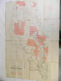
Map - Kiewa Valley, County Map of Bogong, 27/11/1905
This map has been owned by the Ryder Family of the Kiewa Valley for possibly over 100 years (1905?). It was used when the family mustered and maintained cattle on their grazing lease on the Bogong High Plains. Obviously a field map used on these occasions.This map was used by the Ryder Family who lived in the Kiewa Valley and who grazed cattle on their lease on the Bogong High Plains during summer.Showing reserves Under the Forest Act of 1907. This is a paper map which has been mounted or glued on pink and cream floral cotton. It is obvious by its poor condition that it has been used outdoors in the field. It is not in very good condition as it has been folded 4 times (8 divisions) and it is badly worn and cracked in the creases.Photo Lithographed at the Department of Lands and Surveys by T.E.McGauran 27/11/05 Price 1/3d. Scale - 2 miles to an inch. F.S. Hilcke Oct. 2nd 1905.department of lands and surveys map; ryder family; bogong high plains -
 Kiewa Valley Historical Society
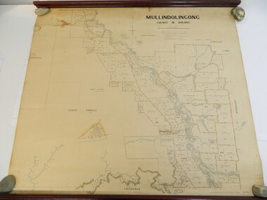
Map - Kiewa Valley, Parish Map of Mullindolingong, 12/10/1906
The map shows the names of people living in the parish of Mullindolingong in 1906. These people had leases or licences giving the reader an insight into the number of people in the area and an understanding of the size of their holdings. Infrastructure is also given including shops, schools, churches etc. Presumably it was used by the Ryder family.This map gives an historical insight into the parish of Mullindolingong as it names people and the infrastructure - roads, buildings etc. as it was in 1906. This enables the reader to compare the area at the time with other times and other places and to have an understanding of the early settlers in the area.This is a very old paper or parchment map with wooden rods top and bottom. The top rod has ribbons attached to enable hanging. The map shows the current leases and licences and when they were held by during this period, circa 1906.Mullindolingong County of Bogong. This plan has been prepared by The Most Reliable Data in the Possession of the Department up to the date of its Compilation. Information respecting Leases or Licences which await Final Completion is not recorded.parish of mullindolingong map; ryder family; early settlers; -
 Kiewa Valley Historical Society
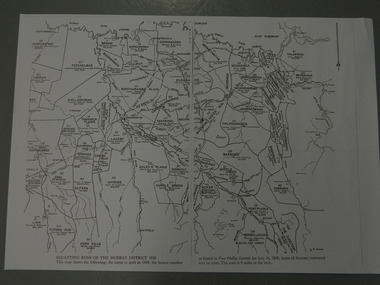
Maps - Squatting Runs of the Murray District 1848 x2, July 26,1848
The Port Phillip Gazette was the second newspaper published in Melbourne, in the then Port Phillip district, now Victoria. In 1948 it was published bi-weekly.The map shows the original names of squatters along the Kiewa River. The names of the district are mostly current today although some are spelt differently.2 copies - 1 laminated & 1 paper of the map of "Squatting Runs of the Murray District 1848." The area is recorded (eg. Tawanga, Dederang, Gundowring, Kergunia, Merrimarenbung all along the Kiewa River) under which the names of the squatter is recorded, the number of acres and the licence number. Scale is 8 miles to the inch.squatting runs; kiewa valley; port phillip district; -
 Warrnambool and District Historical Society Inc.
Book, The Journals of Major-Gen. C.G. Gordon, C.B. at Kartoum (sic), 1885
Journals of General Gordon of KhartoumThis is a book of 316 pages, plus 33 pages of information on other books for sale by the publisher.The book has a dark red cover with gold lettering on the front cover and the spine. The pages contain printed text, two maps, a portrait and thirty black and white illustrations.non-fictionJournals of General Gordon of Khartoumgeneral gordon of khartoum, gordon, kartoum -
 Warrnambool and District Historical Society Inc.
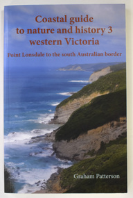
Book - Coastal Western Victoria, Graham Patterson, Coastal Guide to Nature and History 3 Western Victoria, 2022
Description of Western Victorian Coast from Point Lonsdale to South Australian BorderThis is a book of 188 pages. The cover has colour photographs and printing in red and white. The pages contain printed text, maps and illustrations, and black and white and colour photographsnon-fictionDescription of Western Victorian Coast from Point Lonsdale to South Australian Borderwestern victoria coastline, graham patterson, warrnambool, shipwreck coast -
 Warrnambool and District Historical Society Inc.
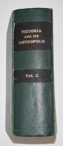
Book, Victoria and its Metropolis Vol 2, 1888
Information on the of Colony of VictoriaThe book has a green cloth cover with an indented pattern. The spine has gold printing on black cloth attached to the green cloth. The 820 pages are gilt edged and, to some extent, are water damaged. They contain printed text and lithographs .Some original pages relating to Warrnambool have been removed and replaced with photocopies which are pasted in. There are fold out coloured maps.non-fictionInformation on the of Colony of Victoria warrnambool history, history of victoria -
 Warrnambool and District Historical Society Inc.
Ledger, Letter book 1892-1904, 1892
This letter book has letters, sketch maps and plans and dates from 1892 to 1904. It came from the office of John William Crawley, Junior, an engineer, architect and surveyor in private practice in Warrnambool and also the engineer of the Shire of Warrnambool from 1895 to 1935. His father, brother and son were also engineers and worked in that capacity or as the Shire Secretary for the Shire of Warrnambool, with the Crawley family recording a total of 132 years of service to the Shire. This letter book was passed on to John Crawley’s son, Rolf Crawley, Engineer for the Shire of Warrnambool from 1935 to 1968. The letter book then came into the possession of Michael Hand who took over the private surveying business of Rolf Crawley in Warrnambool. The Warrnambool and District Historical Society has acquired the letter book, one of several Crawley ledgers, from the Michael Hand estate. This letter book is of considerable significance as it contains maps, plans, sketches and written information which is the work of John William Crawley Junior, the engineer for the Shire of Warrnambool for 40 years. It will be very useful to researchers. This is a hard cover letter book of 500 pages. The cover is black with leather binding on the edges of the cover and on the spine. The pages contain an alphabetical listing of the letters, handwritten letters and many sketch maps and plans. There are several loose pages of plans and diagrams at the back of the book. The inside of the covers has a blue mottled pattern. The edges of the cover are torn. There is a mauve stamp on the first page. ‘Letter Book 1892 to 1901’ ‘Rolf L. Crawley, Civil Engineer, Drainage and Water Supply Engineer, Licensed Surveyor, Registered Architect, Warrnambool’ john william crawley, junior, warrnambool, rolf crawley, warrnambool, shire of warrnambool -
 Warrnambool and District Historical Society Inc.
Letter Book 4, 1901, 1908
This letter book has letters, invoices, sketch maps and plans and dates from 1908 to 1910. It came from the office of John William Crawley Junior, an engineer, architect and surveyor in private practice in Warrnambool and also the official engineer of the Shire of Warrnambool from 1895 to 1935. His father, brother and son were also engineers and worked in that capacity or as the Shire Secretary for the Shire of Warrnambool, with the Crawley family members recording a total of 132 years of service to the Shire. The letter book was passed on to John Crawley’s son, Rolf, Engineer for the Shire of Warrnambool from 1935 to 1968. The letter book then came into the possession of Michael Hand who took over the private surveying business of Rolf Crawley in Warrnambool and the Warrnambool and District Historical Society has acquired the letter book, one of several Crawley ledgers, from the Michael Hand estate. This letter book is of considerable significance as it contains maps, plans, sketches and written information on the work of John William Crawley, the engineer for the Shire of Warrnambool for 40 years. This is a black-covered letter book with copies of letters and field maps and plans and an alphabetical listing at the front. Some of the letters are invoices for work carried out. The leather section of the front cover has been almost completely torn away and the binding is mended with adhesive tape. There are some torn pages. The front page has a signature and a mauve stamp. ‘Letter Book’ ‘J.Wm. Crawley (Private)’ ‘ Rolf L. Crawley, Civil Engineer, Drainage and Water Supply Engineer, Licensed Surveyor, Registered Architect, Warrnambool’ ‘4’ rolf crawley, warrnambool, john william crawley, junior, warrnambool, history of warrnambool -
 Warrnambool and District Historical Society Inc.
Letter book 5, 1910
This letter book has letters, invoices and sketch maps and dates from 1910 to 1914. It came from the office of John William Crawley, Junior, an engineer, surveyor and architect in private practice in Warrnambool and also the official engineer for the Shire of Warrnambool from 1895 to 1935. His father, brother and son were also engineers and worked in that capacity or as the Shire Secretary for the Shire of Warrnambool, with the Crawley family recording a total of 132 years of service to the Shire. The letter book was passed on to John Crawley’s son, Rolf, engineer for the Shire of Warrnambool from 1935 to 1968. The letter book then came into the possession of Michael Hand who took over the private surveying business of Rolf Crawley in Warrnambool and the Warrnambool and District Historical Society has acquired the letter book, one of several Crawley ledgers, from the estate of Michael Hand.This letter book is of considerable significance as it contains maps, plans, sketches and written information, the work of John William Crawley, Junior, the Shire of Warrnambool engineer for 40 years. It will be very useful for research purposes. This is a brown-covered letter book of 750 pages with a mottled blue inside lining. The pages contain an alphabetical index and copies of handwritten letters and sketch maps and plans. There is one loose letter dated 1937. The pages are somewhat stained and the spine on the cover has been torn away. There is a mauve stamp on the first page. ‘5’ ‘Rolf L. Crawley, Civil Engineer, Drainage and Water Supply Engineer, Licensed Surveyor, Registered Architect, Warrnambool’ rolf crawley, warrnambool, john william crawley, junior, warrnambool -
 Warrnambool and District Historical Society Inc.
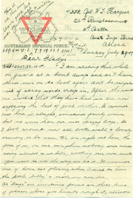
Document, Letters: July 1917 To Gladys from 7358 Pte William Thomas Harper, pre 1917
Original documents, envelopes, diet sheet,letters and photograph sent from abroad from William Thomas harper to Gladys Holmes, Byaduk 7358 Pte William Thomas Harper b. 1896, Byaduk, 8th Battalion - 24th Reinforcements, embarked on 19th February 1917 on HMAT A70 Ballarat. Killed in France on 3rd May 1918. Buried Outtersteene Communal Cemetery Extension, Bailleul France. Cousin to twin AV Harper and RS Harper. one of eight correspondents to Gladys Holmes, ByadukOriginal documents, part of 14 sets of correspondence to Gladys Holmes and local Byaduk residents from local servicemen during WW 1..001803.1: Envelope 001803.2 -.6R: Buff coloured paper, 6 sheets with YMCA logo on map of Australia and red triangle. 001803.7 - 7R: Envelope has a red 1d stamp with 20 SEP 17 black ink postmark and blue ink handwritten address with sender's details. 001803.8 - 8R: note and Diet sheet Week Aug 26 - Sep 2 1917 001803.9 - 9R: Small sepia photograph of physical training soldier, and reverse has handwritten notes001803.1: Envelope, addressed to Miss Gladys Holmes/Byaduk/Hamilton/Victoria/Australia. Postmark ...CAMP B.O. SALISBURY 10 UY 17 001803.2-.6R: Leeter: 24th Reinforcement/2nd Battn/Aust Imp Forces/Abroad/Sunday July 29.17 to Dear Gladys 001803.7- 7R: Envelope: Red id stamp with black postmark 11.45AM, 20 SEP 17, Address-Miss Gladys Holmes/Byaduk/Hamilton/Victoria/Australia. Sender: 7538 8th Batt. Reverse: Received 24th Nov 1917. 18.8.17/Use old/address/still/ 24.8 A.I.F. etc 001803.8- 8R: Note andDIET SHEET Week Aug 26 to Sep 2, Breakfast Dinner & Tea 1001803.9 - 9R: Photograph of physical trainer and reverse has 11 lines of informationwilliam thomas harper, gladys holmes, byaduk ww1, letter, photograph, envelope, a.i.f. -
 Warrnambool and District Historical Society Inc.
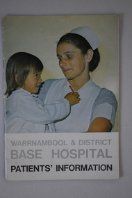
Booklet, Warrnambool & District Base Hospital Patients' information, C1970
This booklet outlines procedures and rules which pertain to the Warrnambool base Hospital. It covers such items as services, admissions, meals, visitors, blood donors, charges, and complaints. A small booklet with social and historical interest to the district.16 page booklet with image of a nurse with a child in her arms on the front cover and text in grey and black on a white background.Back cover has a photograph a woman in a wheelchair with four hospital staff. below is a red cross in a circle with Warrnambool and district Base Hospital around it.It has a map of the site and a table of contents outlining aspects of procedures arpund the hospital.Photography : Roger Lee. Printed by Philprint Warrnambool.warrnambool base hospital, warrnambool, warrnambool and district base hospital -
 Warrnambool and District Historical Society Inc.
Document, Ella Webb, Warrnambool artist, Street Walks of Warrnambool, 2018
This is a tourist guide to Warrnambool produced by a local artist, Ella Webb, in conjunction with the Warrnambool and District Historical Society. It includes a sketch map showing the location of some points of interest – buildings and sites of historical interest, places of interest that are no longer existing, some natural features (mainly along the coast) and some information about incidents and people in the past. It is an attractive broadsheet that is a useful guide for visitors to Warrnambool. This sheet is of interest as a modern-day tourist map produced in an artistic fashion by a local Warrnambool artist.This is a single sheet of thick paper printed on both sides in green, brown, yellow and beige tonings. One side of the sheet has sketches of buildings and places of interest and printing and the other side has a sketch map of some of the main streets of Warrnambool and some of its attractions. -
 Warrnambool and District Historical Society Inc.
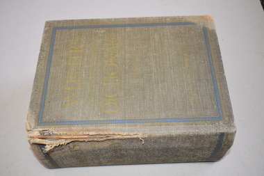
Book, World Publishing Co, Webster Dictionary, 1958
This dictionary is a large tome containing a wealth of information current at the time of publication (1958). The Webster’s Dictionary is an American publication but it was known world-wide and would have been in many households in Australia in the mid 20th century. No information is available on A. M. Archibald (the signature in the front of the book)This book has no known local provenance but is retained as an example of an antiquarian item, a 60 year-old book.This is a large tome of 2129 pages, plus supplements of 160 pages. It has a faded dark green linen cover. The spine and the cover edges are damaged. The wording on the spine and cover are almost indecipherable. Inside the covers are images of a tree with branches representing Indo-European languages. The pages have alphabetical thumb tabs and these are double-sided with gold lettering. The pages contain black and white illustrations and coloured plates. The supplementary material includes coloured world maps, dictionaries of biography, geography and mythology and information on foreign words and phrases, abbreviations, Scripture and the history of Canada.A.M. Archibald Webster’s Dictionary antiquarian books, history of warrnambool -
 Warrnambool and District Historical Society Inc.
Ledger, Copy Title Book Vol. 1, Late 19th and early 20th centuries
This ledger is Volume One of a series of Copy Title Books that contain certificates of land titles from the Warrnambool district in the late 19th and early 20th centuries. It came from the former premises of the Warrnambool legal firm, Mackay Taylor. This firm originated in the 1890s when George Mackay established a legal practice in Kepler Street, Warrnambool. In 1893 he bought the legal business of James Fletcher, following the death of the latter and the practice became known as Fletcher and Mackay. In 1926 John Taylor became a partner with George Mackay (who died that year) and Mackay, Taylor and Co continued on until 1999 when the firm merged with Tait Solicitors and became Tait Taylor. In 2010 it was renamed Taits Legal. This ledger is of great importance as it contains early certificates of titles of land and property in the Warrnambool district. The information contained therein will be of significant importance to researchers of local history.This is a hard cover book of 200 pages with a mottled green cover and black binding. The index is typed and the contents include certificates of land and property titles and some sketch maps.warrnambool land and property, mackay taylor, history of warrnambool -
 Warrnambool and District Historical Society Inc.
Documents, Late 20th, early 21st centuries
These ten documents (maps, plans, photographs) mostly come from the Warrnambool City Council and most contain information on sub-divisions and titles of properties in areas around the Central Business District of Warrnambool. The dates range from 1986 to 2006. These maps, plans and photographs are of some interest as they give historical details of subdivisions in Warrnambool and date from the late 20th century. .1 This is a laminated map of the boundaries of Local Governments in Victoria. It is Sheet I of 2 and has red and blue pencil markings and black boundary markings. .2 This is a copy of a plan of a survey in black and white markings on paper. .3 This is a plan of the title details of Section 19 Warrnambool. It has black printing on buff-coloured paper. .4 This is a plan of the allotments in part of the Central Business District of Warrnambool. It is printed in black and white. .5 This is a 2006 coloured aerial photograph of the harbour at Warrnambool – Breakwater etc. .6 This is a 2006 coloured aerial photograph of the Lake Pertobe area in Warrnambool .7 This is a coloured aerial photograph of Warrnambool’s streets over-stamped with road numbers in large blockings. .8 This is a plan showing the title details of Section 11 in Warrnambool. It has black printing on buff-coloured paper. .9.1 This is a plan of sub-divisions in parts of Crown Allotments 38 & 39 in Warrnambool. It has green, pink and yellow markings with black printing. .9.2 This is a plan of the sub-divisions in parts of Allotments 38 & 39 in Warrnambool. It has pink, yellow and blue markings with black printing. It is somewhat faded. warrnambool c.b.d. maps and plans, history of warrnambool -
 Eltham District Historical Society Inc
Document - Folder, Shire of Eltham Historical Society, Heritage Week, 1982-1996
Various informational material for Heritage Week themes by year along with Shire of Eltham Historical Society forms and copies of activities Includes 1989 self guided tour with map of 36 historical locations provided as part of the Shire of Eltham Historical Soiciety's activities for Heritage Week 1989 and also 1983 (recreated from display materials)eltham heritage walk, heritage week, heritage week 1989, shire of eltham historical society -
 Eltham District Historical Society Inc
Folder, Thomson, Donald
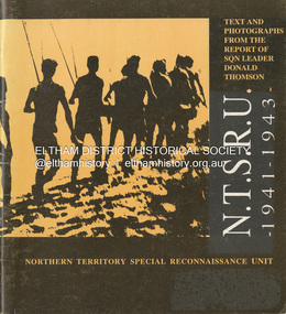
1. Book: N.T.S.R.U., 1941-1943 : Northern Territory Special Reconnaissance Unit / text and photographs from the report of Sqn Leader, Donald Thomson [Foreward: Michael Christie, Steve Fox, Nawunggurr, Yunupingu] Summary Work of the Yolngu reconnaissance patrol in the Northern Territory during Second World War as described in the report by Donald Thomson who trained and led them; list of names of members of the Unit; mention of Caledon Bay killings. Title N.T.S.R.U. : 1941 - 1943 / [text and photographs from the report of SQN Leader Donald Thomson : Michael Christie, Steve Fox, Nawunggurr, Yunupingu]. Author Thomson, Donald F. (Donald Fergusson), 1901-1970. Other Authors Christie, Michael. Fox, Steve. Yunupingu, Charles Nawunggurr. Published [Nhulunbuy]:Yirrkala Literature Production Centre , 1992. Carrier Types volume Physical Description 31 p.; ill., map, ports. Notes Cover subtitle; Northern Territory Special Reconnaissance Unit; Foreword in Yolngu text, parallel English translation. Language English Identifiers ISBN 0864093055Folder of information on Donald Thomsondonald thomson -
 Eltham District Historical Society Inc
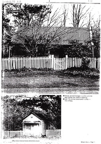
Document - Folder, Jarrold Cottage (White Cloud), 701 Main Road, Eltham, c.2002-c.2014
Information pertaining to the former Jarrold Cottage built in the early 1850s which has been in the Skipper family since 1944 Contents: 1 Journal Article: Jarrold Cottage; This quaint house survived fire and flood, Eltham Shire, newsletter c.2002, p10-11 2. Newspaper article: Cottage of 1800s, 100 Years of News Special Edition, (Leader Newspapers), August 27, 1997, p36 3. Jarrold Cottage (7), extract from tourist drive map publication (unknown) 4. Journal Article: Eltham . . . then and now, written by Judy Lewis, Eltham Town Community News, pp10-11, date unknown with hand written comments/corrections by Diana Bassett-Smith. Features Jarrold Cottage, Southernwood and Walter Withers and the former CBA Bank building. 5. Artice: Jarrold Cottage or White Cloud Cottage, compiled by Harry Gilham (2 pages)Folder of information on Jarrold Cottage consisting of 5 A4 photocopies and one A3 (colour) two page journalbootmakers cottage, cba bank, eltham, jarrold cottage, main road, southernwood, walter withers, white cloud cottage -
 Eltham District Historical Society Inc
Document - Folder, Wellers of Kangaroo Ground, 1984-2017
Wellers of Kangaroo Ground Vertical File Contents: 1. Article: History of Wellers Restaurant by Sandra Cahir, revised 2017. 7 pages 2. Article: Weller’s Hotel of Kangaroo Ground (final draft) by Jim Allan, 1 June 2017, including feedback email from Sandra Cahir (7 May 2017). 3. Printout of online image - Kangaroo Ground landholders from 1841, Kangaroo Ground Presbyterian Church. (2022, June 29). Retrieved from https://kgpc.pcvic.org.au/images/history_images/Kangaroo-Ground-landholders.jpg 4. Folder of printouts of historical newspaper articles referencing the hotel 1866-1911 https://trove.nla.gov.au/list/163201 5. Printouts (various versions) from Victorian Heritage Database (National Trust and Nillumbik Shire) https://vhd.heritagecouncil.vic.gov.au/ 6. Collection of research notes, copies of records from various publications including EDHS Chronology of Events and Kangaroo Ground: The Highland Taken by Mick Woiwod, pp90, 180-181 (EDHS_01618). 7. Report: Request for ministerial amendment to use the property as a restaurant, includes existing conditions and plan for development, 1 November 1984 8. Papers donated by Diana and Peter Bassett-Smith including: a. Photocopy of Weller’s Hotel, Licensee M. Weller b. Letter: Shire of Eltham to Office of the Secretary for Planning and Environment, 23 Feb 1984 - Information regarding inclusion of Wellers Hotel into the Historic Buildings Register c. Letter: Historic Buildings Council letter to Peter Bassett-Smith seeking historical information on Wellers Hotel, 10 Jan 1985 d. Memo: Peter Bassett-Smith to Robert N. Hendrey on history of Wellers Hotel, 28 Jan 1985 - Includes extract of information about Mary Weller, Dept. of Crown Lands and Survey Map NILLUMBIK showing properties of John Weller and E. Weller and a Diamond Valley News article from 10 April 1973, p11, "Eltham on old coach route" 9. Information about the Weller family including family trees from various sources a. Edward Weller, Pioneer Families in Victoria, http://mepnab.netau.net/w/w09.html, 1 Jan 2017 (link broken) b. The WELLER family tree. (2017, January 1), 2 pages. Retrieved from https://www.weller.org.uk/cgi-bin/FamilyTree/ShowFamily.pl? and 27 pages Retrieved from https://www.weller.org.uk/cgi-bin/FamilyTree/ShowFamily.pl?ListAllPeople=A c. Edward WELLER on the WELLER family tree. (2017, January 1), 1 page. Retrieved from https://www.weller.org.uk/cgi-bin/FamilyTree/ShowFamily.pl?PersonID=516 d. Photograph (print copy), believed to be Edward Weller, 1836-1883 e. Photograph (print copy), Gravestone of Weller family at Kangaroo Cemetery f. Wellers of Kangaroo Ground, 1 page, possibly from History, http://www.wellers.com.au (broken) c.2016 g. Edward and Mary Weller miscellaneous biographical research notes (by Jim Allen?) including from Ancestry.com, and extracts from Chappel file (EDHS_04448) with relevant names highlighted h. Information about the Vernon Pitman family from Ancestry.com 10. Newspaper articles: a. Cobb & Co called here by Marguerite Marshall; Diamond Valley News, May 4, 1982, p2 b. Rich is history, 30 August 1983 (very similar to previous article) c. Weller’s Pub - restaurant, craft store or art gallery? Diamond Valley News, October 22, 1985, p3 d. Despite years of neglect a magical charm lies waiting, Diamond Valley News, October 29, 1985 e. Old pub fate still in doubt, Diamond Valley News, (?) 29 October 1985 f. Renovated Weller’s Pub to begin its new stage of life, DVN 26 January 1988 g. Wellers Restaurant, Lynne Hillier, Network, October 1988, p14 h. Revolution at Wellers, Nillumbik Mail, December 20, 2000 i. Wellers brings on good times, Valley Weekly, June 22, 2005 j. Dine in with ideal outlook, Valley News, 10 August 2005 k. Advertisement: Wellers of Kangaroo Ground, Enjoy lunch, afternoon tea and dinner at Wellers from Tuesday to Sunday, Valley Weekly, Wednesday, August 31, 2005 l. Advertisement: Wellers of Kangaroo Ground, Appearing live; Normie Rowe Fri 24 Feb, Diamond Valley Leader February 22, 2006, p11 m. Advertisement: Wellers of Kangaroo Ground, Lunch Special, Diamond Valley Leader March 27, 2010 n. Braithwaite abounds to Kangaroo Ground, Gig Guide, The Age, Friday, October 8, 2010, p14 o. History up for grabs, Diamond Valley Leader, March 28, 2012 p. Advertisement: Wellers Restaurant, Freehold only for sale, Morrison Kleeman, Diamond Valley Leader, March 28, 2012 q. Restaurant’s crash course, Megan Bailey, Diamond Valley Leader, January 1, 2014, p3. Also accessible online - Staff praised after car crashes through Kangaroo Ground eatery. (2022, June 29). Retrieved from https://www.heraldsun.com.au/leader/north/staff-praised-after-car-crashes-through-kangaroo-ground-eatery/news-story/021c896a1ab6d76bd6b73f2e57dc1854 r. Eatery set for revival, Brittany Shanahan, Diamond Valley Leader 15 February 2017; Also, online as Much-loved Wellers of Kangaroo Ground to be relaunched as Italian restaurant Fondata 1872. (2022, June 29). Retrieved from https://www.heraldsun.com.au/leader/north/muchloved-wellers-in-kangaroo-ground-to-be-relaunched-as-italian-restaurant-fondata-1872/news-story/665777fb347584ef483867ae2b536a8f s. Fondata 1872 proves a big hit with food, Diamond Valley Leader 3 May 2017, p3 11. Wellers of Kangaroo Restaurant Bar Entertainment Functions, tri-fold brochure promotional brochure 12. Website Printout: Wellers Restaurant, Live Guide, (2017, January 5). Retrieved from http://www.liveguide.com.au/Restaurants_Bars/VIC/Kangaroo_Ground/Food_Styles/3... 13. Website Printout: Wellers of Kangaroo Ground, Only Melbourne (2017, January 30). Retrieved from http://www.onlymelbourne.com.au/wellers-of-kangaroo-ground 14. Printouts from Fondata 1872 website and Facebook page including colour photograph of sign in front and business card (2017). Related EDHS Collection items • Wellers Hotel of Kangaroo Ground by Jim Allen, Part 1, Newsletter No. 235, Eltham District Historical Society, August 2017. Retrieved from https://elthamhistory.files.wordpress.com/2017/08/edhs-nl-235-aug-2017.pdf • Wellers Hotel of Kangaroo Ground by Jim Allen, Part 2, Newsletter No. 236, Eltham District Historical Society, October 2017. Retrieved from https://elthamhistory.files.wordpress.com/2017/10/edhs-nl-236-oct-2017.pdf • EDHS_03997 - Slide, Wellers Hotel, Pitmans Corner, Eltham-Yarra Glen Road, Kangaroo Ground, c.1975 https://victoriancollections.net.au/items/5e59e36221ea671798ac40eb • EDHS_03998 - Slide, Wellers Hotel, Pitmans Corner, Eltham-Yarra Glen Road, Kangaroo Ground, c.1975 https://victoriancollections.net.au/items/5e59e39e21ea671798ac9c27 • EDHS_03999 - Slide, Wellers Hotel, Pitmans Corner, Eltham-Yarra Glen Road, Kangaroo Ground, c.1975 https://victoriancollections.net.au/items/5e59e3c721ea671798acd2ef • EDHS_04000 - Slide, Wellers Hotel, Pitmans Corner, Eltham-Yarra Glen Road, Kangaroo Ground, c.1975 https://victoriancollections.net.au/items/5e59e3e021ea671798acfd68 • EDHS_04066-18 - Photograph, Wellers Restaurant, Eltham-Yarra Glen Road, Kangaroo Ground, c.Mar. 1989 https://victoriancollections.net.au/items/610f4dafa346aadcee7ac79c • EDHS_04041-26 - Photograph, Wellers Restaurant, 150 Eltham-Yarra Glen Road, Kangaroo Ground, c.May 1988 https://victoriancollections.net.au/items/610e2f4a7d65e7c945a35e69 • EDHS_04437 – Newsclipping, Renovated Weller's Pub to begin its new stage of life by Linley Hartley, Diamond Valley News, 26 January 1988 https://victoriancollections.net.au/items/5de4913921ea6710a46a85c7 • EDHS_04438 - Newsclipping, Wellers Restaurant by Lynne Hillier, Network, October 1988, p14 https://victoriancollections.net.au/items/5de4916f21ea6710a46aea0f • ArtStreams magazine (from Volume 9, 2004) ‘partnered' with Wellers in promoting and supporting the arts and culture. Various advertisements throughout, particular with live performance acts. Numerous references throughout to art and music performances on site. • Stephen Cummings and Joe Camilleri at Wellers Kangaroo Ground, ArtStreams, Vol. 9, No. 4, Sep/Oct 2004, p17 EDHS_04406 - Journal, ArtStreams: Whittlesea, Banyule, Darebin, Manningham, Nillumbik, Yarra; Vol. 9, No. 4, Sep-Oct 2004 https://victoriancollections.net.au/items/5bcc086021ea6804a82a92a9 • Daryl Braithwaite rocks up at Wellers, Fiona Sievers, ArtStreams, Vol.10 No.2, 2005, pp6-7 EDHS_04409 - Journal, ArtStreams: Vol. 10, No. 2, 2005 https://victoriancollections.net.au/items/60f5416ab06f0c13a9419541 • Ephemeral Sculpture by Peter Dougherty, ArtStreams, Vol.10 No.3, 2005, pp7-9. About sculptures created in or on the grounds of culinary establishments throughout the Shire. - Denise Keele-Bedford constructed ‘Ou Well’ at Wellers Restaurant and Vicky Shukuroglou, also at Wellers set up cotton banners printed and painted with natural dyes from onion skins, spinach, radish beetroot, turmeric and charcoal. EDHS_04410 - Journal, ArtStreams: Vol. 10, No. 3, 2005 https://victoriancollections.net.au/items/60f5436db06f0c13a941ae19 • Music at Wellers Restaurant, ArtStreams, Vol.10 No.4, 2005, p23 EDHS_04411 - Journal, ArtStreams: Vol. 10, No. 4, 2005 https://victoriancollections.net.au/items/60f543e4b06f0c13a941b059 • Weller’s Pub, Diamond Valley sketchbook / text by Brian McKinlay ; drawings by Graham Hawley, 1973, pp42-43 EDHS_00856 - https://victoriancollections.net.au/items/590852edd0ce7b14e8177da3 • Gold Field Coaches Stopped Here, Nillumbik now and then / Marguerite Marshall; photographs Alan King with Marguerite Marshall, 2008, pp86-87 EDHS_00977 - https://victoriancollections.net.au/items/5935f315d0cdd42c80f9cc52 External Links: • Historic Kangaroo Ground venue comes up for rare sale. (2022, June 29). Retrieved from https://www.smh.com.au/business/companies/historic-kangaroo-ground-venue-comes-up-for-rare-sale-20120325-1vshw.html • Wellers, Kangaroo Ground property sold with leaseback. (2022, June 29). Retrieved from https://www.urban.com.au/expert-insights/investing/37735-wellers-kangaroo-ground-property-sold-with-leaseback • Wellers, Kangaroo Ground | With Mark Seymour, at one of his …. (2022, June 29). Retrieved from https://www.flickr.com/photos/robertmilesdesign/4564390893/ • 2016 Notice of proposed deregistration - WELLERS OF KANGAROO GROUND PTY LTD 124 435 409. (2022, June 29). Retrieved from https://publishednotices.asic.gov.au/browsesearch-notices/notice-details/WELLERS-OF-KANGAROO-GROUND-PTY-LTD-124435409/35d43b89-159a-4435-963f-daec688a61ca • Search results for: Websites (archived). (2022, June 29). Retrieved from https://trove.nla.gov.au/search/category/websites?keyword=%22wellers%20restaurant%22 29 June 2022 edward weller, wellers of kangaroo ground, wellers hotel, wellers restaurant, mary weller, pittmans corner, fondata 1812 at wellers, historic buildings register, hotels, john weller, kangaroo ground, pitman's corner, bassett-smith collection -
 Eltham District Historical Society Inc
Photograph - Colour Print, Belle Vue, Livingstone Road, Eltham, c.2015
Belle Vue property in Livingstone Road, Eltham was once owned by Society member Jo McCormick. Jo was a valued member of our committee and dear friend of many of our members until her death in 2009. Belle Vue is the farmhouse of a property that is now a significant part of suburban Eltham, just a short distance north of the town centre. Originally purchased by pioneer Eltham farmer Henry Stooke, the present-day old farmhouse sits within an extensive suburban residential area. The history of the property is largely based on a heritage assessment prepared by consultant Lorraine Huddle for Nillumbik Shire Council. Additional information from our Society records reveals Belle Vue farm comprised about 56 ha (140 acres) extending northerly from the northern boundary of Holloway’s 1851 Little Eltham subdivision. On the present day map the southern boundary was just north of Elsa Court and Grove Street. The western boundary was the Diamond Creek and extended northerly to Main Road where it turns easterly towards Research. It was traversed by the main road to Kangaroo Ground and beyond and from 1912 by the railway to Hurstbridge. From 1895 the farm was owned by William Williams and his wife Mary Ann. In 1914 -15 they built a new house now known as Belle Vue. They sold the land in 1920 and residential subdivision began soon after that. Belle Vue remains today on a substantially subdivided and very much reduced size residential lot in Livingstone Road. The house and many old trees on the site were subject to a heritage overlay under the Nillumbik Planning Scheme. Despite that overlay, the development and subdivision of the original land resulted in most of the heritage listed trees being removed. belle vue, eltham, livingstone road -
 Eltham District Historical Society Inc
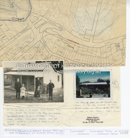
Document - Property Binder, 1203 Main Road, Eltham
Display panel: Map of Coleman's house location; 1904 photograph of Coleman house with Tom Newton, Mary Coleman (later Dowes) Mary Ann Coleman (nee Burke, mother of Jack Coleman, George Coleman, Mary Coleman), George Coleman, John (Jock) Coleman (father of John Coleman junior married to Margaret Coleman nee Dare); 1971 photograph of part of Coleman house. Typed document, compiled by Dorothy Peatling, Objection to Application 980731 Proposal for 6 units at 1203 Main Road Eltham, stories from Mrs Thomas, Ken Gaston, Frank Martin, Vicky Weston (nee Coleman), Frank Burgoyne, Heather Bakos, Mrs Dansey, and other historical information. Typed document, by Margaret Jennings, Objection to Application 980731 Proposal for 6 units at 1203 Main Road Eltham, history of site. Typed document, by Eltham District Historical Society, history of site, summary of interviews from Dorothy Peatling objection.main road, eltham, property, houses, coleman house, coleman crescent, mary coleman, mary dowes, mary ann coleman, mary ann burke, jack coleman, george coleman, john coleman, jock coleman, margaret coleman, margaret dare, dorothy peatling, mrs thomas, ken gaston, frank martin, vicky weston, vicky coleman, frank burgoyne, heather bakos, mrs dansey, wattletree road, edendale farm, orchard avenue eltham north, diamond creek, christmas creek, cobb and co royal mail -
 Eltham District Historical Society Inc
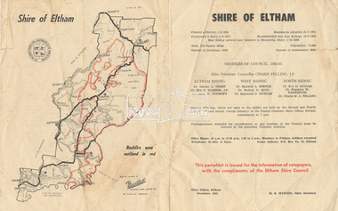
Document - Pamphlet, Shire of Eltham, December 1962
This pamphlet was issued for the information of ratepayers, with the compliments of the Eltham Shire Council. Subjects of information included: Shire statistics and history Members of Council 1962-63 Bushfires Dogs Rates Works Programme Shire Offices Town Planning Map of Shire of Eltham with Bushfire area outlined in redbushfires, charis pelling, charles m. a. pelling, councillors, dogs, eric dudley butler, eric percival harmer, franklin william nankervis, george l. cresp, leslie christopher docksey, m.b. watson, map, maxwell alexander spence, rates, raymond clive duncan, rodney d. quin, shire of eltham, shire offices, town planning, works programme -
 Eltham District Historical Society Inc
Document - Folder, Panton, Joseph Anderson
Joseph Anderson Panton (1831-1913) came from Scotland to Australia in 1851. In Bendigo, he was appointed assistant gold commissioner 1852 and senior commissioner 1854. Over the years, he served as magistrate at Jamieson-Wood's Point, Anderson's Creek, Heidelberg, Geelong and Melbourne. He owned land on the Yarra River and Panton Hill is named for him. Contents Map: J A Panton's landholding with surrounding landholders. Printout and photocopy: Panton, Joseph Anderson, Australian Dictionary of Biography entry. Notes: Joseph Anderson Panton, brief biographical notes. Research Enquiry Form: Vivienne Worthington, seeking sources of information regarding Joseph Anderson Panton, 14 June 2017. Email and associated documents: Michael Kennedy seeking assistance of Eltham Gateway Action Group regarding proposed felling of manna gum tree near bridge across Diamond Creek, on land once held by Joseph Anderson Panton. Newspaper article: "Historic painting might be lost to Victoria," The Age, 22 October 1985. Painting by Joseph Anderson Panton of Captain William Lonsdale's house, Victoria's first Government House, to be in forthcoming auction. Newspaper clippings, A4 photocopies, etcjoseph anderson panton, william b burnley, w walsh, r hall, r a davidson, j orford, b speers, a speers, william bell, t baillie, d mcloughlin, t prior, g e hodgkins, n rodda, w r belcher, g d boursiquot, j p imley, t b darling, h g jones, t sweny, r lane, w gordon, a e morris, d w thring, j carfrae, thomas sweeney, michael kennedy, vivienne worthington, william crozier, j frank, p carrucan, panton hill -
Glen Eira Historical Society
Article - Joyous Gard
Two copies of a one page photocopy from the book Australian Sculptors (1980) by Ken Scarlett, describing the Springthorpe Memorial at Boroondara Cemetery, Kew. The file also includes a photocopy of an article by Chrys Spicer, date and source unknown, about the Springthorpe Memorial. The article includes seven photographs of the memorial. A research note by Chloe Stapleton, dated 31/08/12, suggests a possible source for this article. The file also includes a copy of a typed letter from Allan M Doble to Melbourne University Art Curator Heather Lowe, dated 24/03/1995, concerning the history of the Wheel of Life Sculpture originally located at Joyous Gard. The file also includes a copy of a typed letter, dated 19/05/1995, from Allan Doble to the Melbourne University Gallery with information about the Wheel of Life sculpture Also included in the file are photocopies of two Melway maps showing the location of Joyous Gard and Springthorpe Reserve with notes by Allan Doble, dated 24/03/1995. The file also includes eight coloured photographs (100mm x 150mm) of the Wheel of Life sculpture now located in the Medical School of the University of Melbourne, date and photographer unknown, probably 1990s. Negatives are also included.springthorpe memorial, boroondara cemetery, gilbert web c, gilbert webb, the wheel of life, springthorpe john william, inglis annie constance, springthorpe dorothy, springthorpe annie constance, springthorpe enid, springthorpe lancelot, springthorpe guy, joyous gard, doble allan m, doble mrs allan, murrumbeena primary school, springthorpe reserve, joyous gard court, tyers s w, outer circle railway, boyd park, wahroonga crescent, murrumbeena, caulfield city council, boyd’s pottery, linear park -
Glen Eira Historical Society
Map - Coimbra, 5, Chaddesley Avenue, St Kilda East
A two page photocopy of a typed letter from Peter Upton, dated 10/04/1981, requesting information on the property Coimbra in Chattersley Lane (sic), St Kilda and detailing his family’s involvement in the property. He describes his memories of the house, its rooms, details of engraved glass, floral and decorative motifs and extensive garden. The file also includes a one page photocopy of a typed letter from the National Trust of Australia (Victoria) to the St Kilda Historical Society, dated 29/04/1981, concerning Peter Upton’s letter and requesting assistance in providing him with information about the relevant property as Coimbra does not appear on the Trust’s records. The letter includes a hand drawn map (62mm x 120mm) of the area in which the property is located. Also included is a one page typed letter from St Kilda Historical Society, dated 03/06/1981, to the Caulfield Historical Society, forwarding the letters received from Peter Upton and the Trust about Coimbra. The file also includes two handwritten versions of a two page letter, the final version dated 07/09/1981, from the Caulfield Historical Society to Peter Upton concerning his inquiry about Coimbra. It provides a brief list of occupiers of Coimbra from 1935 to 1974. Also included are two versions of a one page handwritten letter, the final version dated 07/09/1981, from the Caulfield Historical Society Historical to the St Kilda Historical Society thanking them for previous correspondence regarding Coimbra. The file also includes two handwritten versions of a one page letter, the final version dated 07/09/1981, to the National Trust of Australia (Victoria), from the Caulfield Historical Society, concerning Peter Upton’s inquiry about Combria. This letter is accompanied by a two page copy of the Society’s reply to Peter Upton. Also included is a one page typed letter of acknowledgement, dated 14/09/1981, from the National Trust of Australia (Victoria) to the Caulfield Historical Society.coimbra, upton henry e, saunders william g, causer archibald m, mansions, upton patricia henrietta, coimbra private hospital, connolly d, chaddesley avenue, chattersley lane, st kilda east, east st kilda -
 Eltham District Historical Society Inc
Folder, Pioneers & Painters; Shire of Eltham Historical Society research notes, background information, etc, 1969-1986, 1969-1986
Material pertaining to the production of a history of the Shire of Eltham, "Pioneers & Painters: One Hundred Years of Eltham and its Shire" in recognition of the shire's centenary in 1971 Item Title Caption 04768-1 Newspaper clipping - The Eltham of 1905; Gellibrand our first white visitor? Diamond Valley News, 24 June 1969, p5 04768-2 Newspaper clipping - The Eltham of 1905; Gellibrand our first white visitor? Heidelberger, 25 June 1969 04768-3 Notes on Eltham District Road Board Members 1866-1871 04768-4 Notes on Eltham District Road Board Members 1866-1871 04768-5 Map showing Gellibrand's likely route through district 12-13 February 1836 and Hoddles's route of Febrary 1838 04768-6 Notes by Shire Secretary, M.B. Watson regarding meeting with Reverend Longfield regarding history of St Margaret's Church 04768-7 Alan Marshall's notes from discussion with Mr. F. Barrett regarding SEPP images 611, 635 and 636 SEPP_0611 SEPP_0635 SEPP_0636 04768-8 Transcripts of letter from local residents to Charles Joseph Latrobe requesting a bridge over the Plenty River dated 10 April 1849 and his reply dated 5 May 1849; from Latrobe Library Archives - Land Branch Records 04768-9 Notes on history of Eltham Shire, Centenary events and publication of Pioneers & Painters for release in conjunction of opening of new Library 04768-10 Newspaper clipping - Glossy record of shire's romantic past and the people who made it by Fab Calafuri, Diamond Valley News, Tuesday, December 16, 1986, p18 SEPP_0755-3 Letter: Acknowledgement from Colin J. Bock, Eltham Shire Secretary to A.R. Thomas of Bendigo for copy of 1913 photograph of Shire of Eltham Councilors, 21 May 1973 A.R. Thomas' father Mr. A.G. Thomas, C.E., was the Shire Secretary at the time in 1913. Cross Ref: SEPP_0755 The idea to develop a book on the history of the Shire of Eltham to be edited by noted author, Alan Marshall in celebration of the shire's centenary was initiated in 1969. The Shire of Eltham Historical Society undertook significant research in conjunction with Alan Marshall locating material at various institutions and other societies; interviewing longer term residents and a public campaign through the local press to acquire photographic material for duplication and use in the book. The public campaign received generous response and the material collected became the genesis for the Shire of Eltham Pioneers Photograph collection now held in partnership between Eltham District Historical Society and Yarra Plenty Regional Library (Eltham Library).Paper documents of various sizes and newspaper clippingsa.g. thomas, a.r. thomas, alan marshall, bridge road, charles joseph latrobe, council members, d.w. lachlan, eltham district road board, eltham shire council, ernie orford, f. barrett, francis rogerson, g. bransprone, james donaldson, james johnston, john bell, john thomson, joseph tice gellibrand, lower plenty bridge, m.b. watson, main road, map, patrick turnbull, peter morris, pioneers and painters, post office, rev. longfield, sepp, shire of eltham pioneers photograph collection, shire secretary, st margaret's church, thomas armstrong, thomas bell, thomas sweeney, william bell (1796-1870), centenary celebrations, christmas hills, clifton pugh, david newbury, dudley street, eltham, gareth jones roberts, hurstbridge, john perceval, joy peck, kangaroo ground, kinglake, lower plenty, luther haley general store, montmorency, neil douglas, panton hill, peter glass, research (vic.), sheila ferguson, shire of eltham, st andrews, yarra glen -
 Eltham District Historical Society Inc
Document, Russell Yeoman, Tour of Historic Buildings and Locations, 1978
Self guided heritage tour information produced by the Shire of Eltham Historical Society for 1978 Eltham Community Festival of 36 locations each numbered on accompanying map. Locations and detail provided current to 1978: 1. ELTHAM SHOPPING CENTRE Whilst very little remains in the centre of historical importance, this area has interest as the "village" which developed over many years following the opening of the railway from Melbourne in 1902. Previously the shopping centre had been spread out over a long length of Main Road to the south. Shops have been continuously demolished or remodelled and the majority of buildings date from the 1950's or later. The recently erected Post Office replaced the "old" Post Office opened on the same site only in 1958. 2. WOOLWORTHS ELTHAM VILLAGE Part of the site of this modern shopping development was occupied by the former Eltham Shire Offices and Hall. The hall was paid for by public subscription whilst the Council raised a loan for the offices. The combined building was opened in 1941. It served as office and Council meeting place until 1965 and as the hall until its demolition in 1970. 3. ELTHAM WAR MEMORIAL The complex of buildings adjoining the present Shire Offices were financed by public subscription as a Memorial following World War II. Their construction and for many years their operation was organised by the now disbanded Eltham War Memorial Committee. The original buildings were the; Infant Welfare Centre, Children’s Library (now War Memorial Hall and Dental Clinic) and Kindergarten. In later years the Elderly Citizens Club was built at the rear. 4. ELTHAM SHIRE OFFICES These offices were opened in 1965 and extended in 1971 to provide additional office accommodation and the Eltham Library. They represent the last of a long line of offices and meeting places of the Eltham Shire Council and its predecessor the Eltham District Road Board. The building occupies the former site of Shillinglaw Cottage. The three tall cypress trees which stood in front of the Cottage have been retained as a feature of the office surrounds. 5. OUR LADY'S CHURCH AND SCHOOL The Catholic Church and School complex opposite the Shires Offices shows a number of stages in the development of Eltham township. The recently constructed church adjoins its predecessor (now the parish centre). Many years ago the Catholic Church was located opposite Wingrove Park and the present central site follows the northerly drift of the township. 6. SHILLINGLAW COTTAGE The Cottage was built in 1859 by George Stebbing, a local builder who was responsible for a number of other prominent buildings in the area. Its removal from the site of the Shire Offices and re-erection on the present site was financed by public subscription. It is built of handmade bricks laid in Flemish Bond with an unusual design featuring burnt "leader" bricks over the whole facade. The Cottage is occupied by Eltham Fleececrafts and will be open during the Festival and at other times during weekends. It is classified by the National Trust. 7. RAILWAY BRIDGE The timber trestle bridge over the Diamond Creek was built in 1901. Whilst all of its timbers have been replaced at various times over the years the only change to its character has been the addition of pylons and wiring for electric trains in 1923. It is one of very few similar bridges remaining in the metropolitan area. In 1976 a proposal to replace the bridge with an earth embankment and large culvert pipes was abandoned following community protests. The bridge, however, remains under threat because of the necessity for future deuplication of the railway line. 8. ELTHAM CENTPAL PARK The area between the railway and the creek has for many years been used as a park which included Eltham' s main football oval. The access road, Panther Place is named after Eltham's team playing in the Diamond Valley League. In recent years a large area extending to Bridge Street and locally known as the Town Park has been landscaped and added to the area. The excellent blending of the park with the natural landscape of the creek valley has earned a National Trust Landscape Classification. 9. OLD BAKERY On the southern corner of York Street and Main Road is an old house with a shop front which was for many years the local baker's shop. The brick bakery at the rear is of somewhat later vintage than the house. 10. BRIDGE STREET CUTTING Before reconstruction of Main Road this intersection had deep cutting embankments on all four corners, forming a distinctive feature of the entrance to Eltham. Roadworks and private development have levelled the land on the low side of the road. A memorial to the Eltham soldiers of World War I which was located at the north-western corner is now situated at the Eltham R.S.L. 11. HILLTOP MILK BAR For many years this was the site of the Eltham Post Office under the control of the Hunniford family and later their descendants the Burgoynes. It was transferred to this site in 1855, although at that time the building apparently fronted Bridge Str e et. The site contained Eltham's first telephone exchange. The post office was relocated in 1954 but the shop was operated until recently by the Burgoyne family who still own the surrounding land. 12. UNITING CHURCH and former C.B.A. BANK The former Methodist Church was built in 1880 by George Stebbing. The Sunday School extension was built in 1929 and there have been more recent extensions. The adjoining opportunity shop was built as a bank in 1874 and purchased by the Methodist Church in 1954. 13. R.S.L. HALL, TELEPHONE EXCHANGE These relatively recent buildings occupy the site of a row of shops forming part of the early ribbon of business development along Main Road. In front of the R.S.L. building is the World War I Memorial relocated from the corner of Bridge Street and Main Road. 14. ELTHAM COMMUNITY CENTRE Australia's first mudbrick "community building" was opened in April this year. Part of the site of the building was purchased in 1856 by Henry Dendy (of Brighton fame). At the rear of the land near the creek was a steam flour mill whilst Dendy's house was at the Main Road frontage of the land. His purchase totalled about 2 Ha (5 acres) and included land on the opposite side of Maria Street (Main Road). Dendy became a prominent member of the Eltham community and served one term as President of the Eltham District Road Board. In 1867 Dendy sold his land and business to William Ford of Malmsbury and shifted to Walhalla. The avenue of trees leading past the Community Centre to the creek may well have bordered the track to the mill. 15. ELTHAM HOTEL The original part of this hotel was built in 1927 following the burning of the former Watson's Eltham Hotel on the same site. The car park on the opposite side of Main Road was also the site of a hotel variously known over the years as; the Fountain of Friendship, the Fountain and the Evelyn Arms. As the Fountain of Friendship it was the first meeting place of the Eltham District Road Board in 1856. 16. ST. MARGARET'S CHURCH, PITT STREET In 1860 Henry Dendy was appointed Chairman of a committee to establish a church of England in Eltham. He donated part of his land in Pitt Street and in 1861 the church was opened. It was built by George Stebbing and remains in a well preserved state today. Th adjoining old vicarage is now named Dendy Hou se. A new mudbrick church hall is under construction on the site. The church and Dendy House are now listed on the Register of Historic Buildings. 17. NO. 86 PITT STREET Cottage built by George Stebbing and believed to be his home for some years in the 1850s. 18. LIVING AND LEARNING CENTRE The house was built in the 1850s with the kitchen at the front being added about 40 years later. By the creek below the house a number of early Eltham industries were located. These included a tannery and a brewery. 19. ELTHAM COURT HOUSE A Court of Petty Sessions was established in Eltham in 1858 and the present building dates from 1860. It is the oldest public building remaining in Eltham. In its early days the building was used as the meeting place and office of the Eltham District Road Board and as an overflow classroom for the local school. The Court House has been classified by the National Trust. The citation states that it is an example of the simple form of early brick Court House with gabled roof and porch. 20. LANDS DEPARTMENT OFFICE This building is the former police station and is probably of about the same age as the Court House. The lockup at the rear has been demolished but the old stables remain as garages. A licence was first granted for a police station at Eltham in 1856. 21. JARROLD COTTAGE The old Cottage opposite Dalton Street was formerly owned by the Jarrold family. Early records indicate that this was the building leased from the Jarrolds as a temporary police station prior to construction of the building on the corner of Brougham Street. The small building on the corner of the property was used as a boot repairer's shop. The elevated studio at the rear is a more recent construction by the present owners. 22. STATE SCHOOL RESIDENCE Erected in 1891 23. WINGROVE COTTAGE This building fills an important place in the history of Eltham and is now used as a medical clinic. It was built in 1858 for Charles S. Wingrove who was Secretary to the Eltham District Road Board and Shire Council from 1858 to 1904. During part of this period he was also Shire Engineer and was Secretary to the Heidelberg Road Board. The house was used as the office of the Board and Council for many years. Wingrove is buried in the cemetery at St. Helena. 24. WINGROVE PARK The parkland opposite Wingrove Cottage has been named after Charles Wingrove. The old Manna Gums are an outstanding feature of the park. 25. ELTHAM FRI.MARY SCHOOL NO. 209 The school first opened in the slab building in 1855 and operated from the present site since 1857. The oldest part of the present school is the stone building erected in 1876. The first school teacher, David Clark remained at the school until 1888. This school is the government township and has always been known as the Eltham School. An earlier school (no.371) known as Little Eltham School operated in Swan Street from 1853 to 1872. 26. "SHOESTRING" This house was built for school teacher David Clark. It has been extensively extended in recent years but the extensions do not detract from the character of the older part of the building. 27. ELTHAM CEMETERY The cemetery contains the graves of many of the district's pioneers . 28. MONTSALVAT This unique complex of buildings was commenced in 1935 by the late Justus Jorgensen and its development has extended over many years. Montsalvat has exerted a significant impact on Eltham The earth and stone construction of many of the buildings has influenced local architecture to a great extent and it has served as a "nerve centre" of the local artistic community. Montsalvat is open to the public for a small charge. 29. MAIN ROAD BRIDGE This location has been the main crossing of Diamond Creek since the earliest days of settlement. The present concrete bridge was erected in 1925 .and was preceded by a number of timber bridges. 30. ELTHAM LOWER PARK This park, being an unusually large flat area for Eltham, was originally the local racecourse. Horse races were held here from 1855 and the area was gazetted as a reserve for a racecourse and recreation reserve in 1857. The park is well known as a venue for school "bird days" and more recently as the site of the Diamond Valley Railway. This miniature railway features scale models of modern and old locomotives and rolling stock and has operated on this site since 1961 . Before that the railway operated at Chelsworth Park, Ivanhoe. 31. FALKINER HOUSE Frederick Falkiner was one of the earliest settlers in the Eltham township area and occupied a substantial leasehold prior to the first land sales. Early records show that Falkiner was the subject of a number of complaints from his neighbours but he has nevertheless been considered a prominent enough citizen to have a street named for him. This house was the home of Evelyn (Ely) Falkiner a member of Frederick's family. 32. WEST HOUSE Behind the large house on the hill is an early house built by the West family. This was relocated from a site near the front of the land by the present owner Mr. Fabbro. 33. FALKINER HOUSE This very old house is believed to have been the home of Frederick and may have been Eltham's first post office. Falkiner was the first post master for a short period. in 1854/55. 34. WITHERS HOUSE This house was the home of famous artist Walter Withers who shifted here from Heidelberg in 1903. 35. ELTHAM HIGH SCHOOL This school celebrated its jubilee this year, having commenced as the Eltham Higher Elementary School 50 years ago. 36. DIAMOND CREEK FOOTWAY If returning from the High School to the town centre the footpath by the bank of the Diamond Creek provides a pleasant route to finish your walk. The creek is a major tributary of the Yarra River. Together with its own major tributaries Arthurs Creek and Running Creek it commences on the southern slopes of the Dividing Range at Kinglake. It gives the name Diamond Valley to an area extending well beyond its actual drainage catchment.Recognition of the significance of various landmarks to the history of the Eltham community as of 1978‘shoestring’, 1978, bridge street cutting, burgoyne store, c.b.a. bank, diamond creek trail, eltham cemetery, eltham central park, eltham community centre, eltham community festival, eltham court house, eltham festival, eltham high school, eltham hotel, eltham lower park, eltham primary school, eltham railway trestle bridge, eltham shire offices, eltham shopping centre, eltham state school no. 209, eltham village, eltham war memorial, falkiner house, heritage trail, hilltop milk bar, jarrold cottage, lands department office, living, living and learning centre, main road bridge, montsalvat, old bakery, our eltham artistic recollections, our lady help of christian’s church, our lady help of christian’s primary school, pitt street, post office, r.s.l. hall, shillinglaw cottage, st margaret’s church, state school residence, stebbing cottage, telephone exchange, uniting church, west house, wingrove cottage, wingrove park, withers house, woolworths -
 Eltham District Historical Society Inc
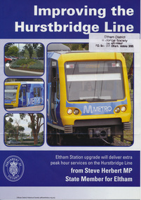
Folder, Hurstbridge Line Upgrade, 2010
... Correspondence and information from the State Government... melbourne Correspondence and information from the State Government ...Correspondence and information from the State Government about the Hurstbridge Line upgrade 2010. Also includes newspaper articles, Nillumbik Shire Council minutes report, map and contextual information regarding the Eltham Major Activity Centre structure Plan 2009. The main area of concern was the plan to reconfigue the Eltham stabling yard.23 documents, 62 pages of news clippings, photocopies and colour political fliersHG Folders 108 and 115harry gilham collection, railway line construction, hurstbridge line, hurstbridge railway line, eltham railway station, eltham station carpark, train stabling yard -
 Eltham District Historical Society Inc
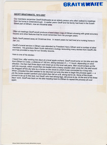
Map, Geoff Braithwaite, Braithwaite ma0p of Eltham circa 1920
A3 photocopy of hand drawn map of Eltham created by Geoff Braithwaite (1914-2008) of his memory of the township about 1920. It includes names of streets and property owners. Folder of information on Geoff Braithwaite Includes A3 photocopy of hand drawn map of Eltham with coloured shading of Eltham in 1920s and 1930sharry gilham collection, eltham, 1920, geoff braithwaite, map, smart family cottage, eltham cemetery, flora caroline braithwaite (nee gamble), geoffrey braithwaite -
 Eltham District Historical Society Inc
Folder, Victorian Goldfields Project: Historic gold mining sites in St Andrews mining division, 1999
Heritage site report and gazetteer by David Bannear, head consultant for archealogy for the Department of Natural Resources and Environment. Includes information on the Warrandyte Goldfield and the Caledonia Goldfield, Queenstown (now known as St Andrews), One Tree Hill, Kingston (now known as Panton Hill), Kangaroo Grounds, You You Hill, Kingstown, South Morang, Nillumbik, (now known as Diamond Creek), Steele's Creek, Yarrambet and Kinglake. Photocopy of map headed: Location of mines and reefs from Geological survey of Victoria, Yan Yean with the Diamond Creek prominant on the map. no date35 page report with map and print out of cover letter (email form) from donorcaledonian gold fields, caledonina gold field, david bannear, gold mining, harry gilham collection, queenstown, st andrews, warrandyte goldfield