Showing 990 items
matching princes street
-
 Orbost & District Historical Society
book, Snowy River Mail as "Mail" Print, Princes Freeway Orbost Section, 2117.1 : 1976 2117.2 : 4.9.2013
The Snowy River Bridge, Princes Freeway, Orbost, Victoria was opened by the Hon. J A Rafferty, Minister for Transport, 25 November 1976. ‘The bridge was built at a cost of A$2.4 million and is the first of four bridges to be built as part of the 8.4 kilometre freeway bypass of Orbost. Construction of the bridges commenced in January 1975, with an expectation to open the bridge across the Snowy River as soon as possible. Less than two years later, on 25 November 1976, the bridge across the Snowy River was opened to traffic, allowing the old bridge to be demolished. The remainder of the Orbost Bypass, both the floodplain crossings and the eastern section around the township itself, was declared ‘Princes Freeway’. The newspaper article was written by David Jellie as part of the centenary celebrations of Vic Roads/Country Roads on 4.9.2013. David Jellie was the project engineer for the Snowy River Crossing Project.This book and article contain historical information and details about the construction of the bridges on the Orbost section of the Princes Freeway.2117.1 isaA thin paperbook book which contains a map, history and construction details of the Princes Freeway at Orbost. It has a program for the opening ceremony of the snowy River Bridge in 1976. 2117.2 is an article from the snowy River Mail on the history of the highway. It is dated 4.9.2013.In pencil - 20csnowy-river-bridge jellie-david princes-freeway-orbost -
 Orbost & District Historical Society
black and white photograph, 1913
This photograph is of the low level bridge across the Bemm River about 50 km east of Orbost in East Gippsland.This is a pictorial record of the 1913 low level bridge across the Bemm River, East Gippsland.A large black / white photograph of a horse - drawn wagon on the low level Bemm River bridge. In the foreground on the bridge is a dog.on back - "Country Roads Board Princes Highway low level bridge" -
 Orbost & District Historical Society
black and white photograph, 1913
This photograph shows the regrowth of vegetation on the road between Genoa and the border - now the Princes Highway.This is a pictorial record of the main road from Orbost to the New South border, The Princes Highway, in the early 20th century.A large black / white photograph of a bush road wwith a vehicle and a man on the side of it.on back - " Princes Highway showing the regrowth.....1913"princes-highway-genoa transport -
 Orbost & District Historical Society
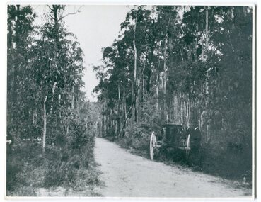
black and white photograph, 1924
History unknown. Oswald Stuart Green taught at the Bete Bolong State School in the 1920s /30s. He wrote many books about East Gippsland including several on thee Orbost / Marlo district.Oswald Green has an association with the Orbost area.A black / white photograph of a dirt road in the bush with a motor vehicle on the road and a man standing beside it.on back - " O.S. Green 31 Malcolm St Blackburn Princes Highway east of Coolwater Creek."princes-highway-coolwater-creek green-oswald-stuart -
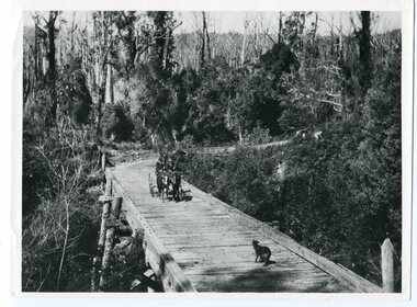
 Orbost & District Historical Society
black and white photograph, late 19th century
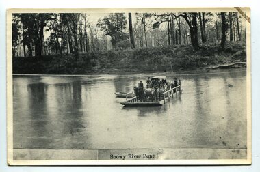
A punt crossed the Snowy River at Orbost from 1884. A bridge was constructed in 1893, but was soon damaged by a huge flood. Flooding was a regular occurrence, the worst inundations being in 1870, 1893, 1925, 1934, 1952 and 1971. Over the years major flood protection works have been implemented. The Princes Highway, which passes Orbost, now crosses the flood plain on raised concrete supports. (info, from Victorian Places Orbost)This item is associated with the Snowy River and its history. It is a pictorial record of transport in the late 19th century.A black / white photograph (copy) of a punt loaded with people and a horse-drawn carriage making its way across a river.on front at bottom - "Snowy River Punt"snowy-river-orbost transport shipping -
 Orbost & District Historical Society
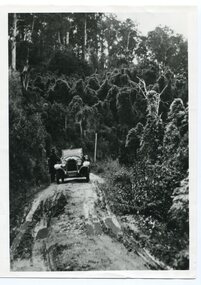
black and white photograph, 1918
Tonghi Creek is 66km north - west of Orbost. Prior to the sealing of the Princes Highway west of Orbost, the road surface was anything but good, even by C1917 when cars started to use the road. From Orbost the old road via Marlo to Sydenham was abandoned for the new location which traversed more rugged country via Cabbage Tree, Bell Bird and Club Terrace to Cann River, and the reason for this diversion was on account of settlements being established at Murrungowar and Club Terrace, at which latter place there was a temporary rush to obtain gold. This road was constructed by the Public Works department and a maximum grade of 1 in 19 was adopted, and as speed was not to be catered for the grade followed in and out round the spurs and gullies, resulting in a maze of turns and twists which required a good deal of skill on the part of the horse driver to negotiate." - Bairnsdale Advertiser, Friday, May 2, 1947. (More information from Newsletter February 2010)This item is a pictorial record of roads in the early 20th century in East Gippsland.A large black / white photograph of a bridge over a small creek, surrounded by bush. The photograph is mounted on a thick cream coloured card.on back - "Bridge at Tonghi Creek 1918"tonghi-creek-bridge country-roads-east-gippsland -
 Orbost & District Historical Society
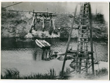
black and white photographs, 1915
This photograph is of the construction of the first road bridge over the Genoa River - 1915. Before today's timber truss and concrete bridge was constructed between 1926-1928 by contractor J.T. Noble Anderson, two earlier bridges crossed the Genoa River at this location. They provided crucial links in the Princes Highway route from Melbourne to Sydney. The letter on the back of the postcard was written by Gordon ? to Alex ? on 2nd October 1917. "this represents the opening of Genoa Bridge. Mrs Alexander cutting the ribbon and Mr Martin holding it at the other side. Did most of the speaking. The gent holding the roll of paper is who came to open the bridge. I can't think of his name. Hubert is standing up at the right / Gordon " This is a pictorial record associated with the history of Genoa in East Gippsland.1100 -A large black / white photograph on a cream coloured buff card. It is of an unfinished bridge with men working there. A small rowboat can be seen on the far side of the river. 1100.1 - A photograph / postcard of the opening of "Genoa Bridge 1917". There is a ribbon stretched across the timber decking road in front of a group of people. 1100.2 - A black / white photograph of a road bridge across a river.on back - "Princes Highway - the 1st bridge over the Genoa River - 1915" on back of 1100.1 is a hand-written letter.genoa-bridge princes-highway-east-gippsland -
 Orbost & District Historical Society
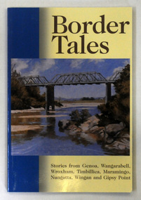
book, Border Tales, 2000
The book was compiled by Peter Allard and Geoff Alves and published by the Genoa Town Committee. Genoa is a small town in East Gippsland, Victoria. It is close to the New South Wales border where the Princes Highway crosses the Genoa River.A paperback book of 120pp titled Border tales : stories from Genoa, Wangarabell, Wroxham, Timbillica, Maramingo, Nungatta, Wingan and Gipsy Point. On the front cover is a coloured picture of the bridge across the Genoa river at Genoa. -
 Orbost & District Historical Society
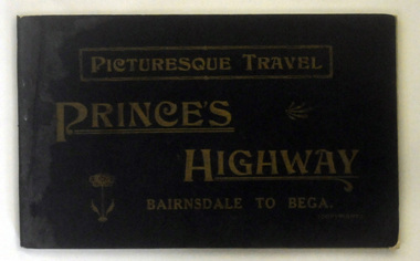
book, Vogt, H, Picturesque Travel Prince Highway, C 1921
Possibly owned by A. C. Nixon. This book was donated by Peter Nixon.A small 139 pp book with a black /dark brown cover and gold lettering. It is titled Picturesque Travel Prince's Highway Bairnsdale to Bega. The back cover is green.inside - Presented to Orbost Historical Society by Peter Nixon, Chief Commissioner, Shire 1/2/97.travel prince's-highway car-touring -
 Orbost & District Historical Society
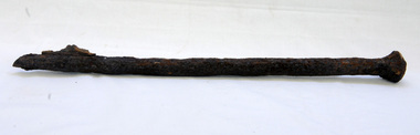
bridge spike
This spike came from the old Brodribb River bridge which is about 9.6 kilometres from Orbost. The Brodribb River joins the Snowy River north of Marlo. In 1906, a bridge replaced the punt over the Brodribb River, improving communication with Orbost. It was eventually replaced by a reinforced concrete bridge built by the Road Construction Authority in 1989 where the Princes Highway passes over the Brodribb RiverThis item belongs to a significant local structure which has been replaced.A very rusty iron bridge spike from the old Brodribb Bridge.brodribb-river bridge-spike -
 The Beechworth Burke Museum
Photograph, 1983
These five images, photographed in 1983, depict locations in Ireland that Ned Kelly's father, John "Red" Kelly may have frequented. John Kelly was born on the 20th of February 1820 and worked as a laborer in Ireland. His parents were named Thomas Kelly and Mary Cody. He had a fresh complexion, large head and reddish coloured hair. John Kelly was sentenced in Tipperary, Ireland for the theft of a pig and received 7 years in Van Diemen's Land (now known as Tasmania). He sailed on the ship "Prince Regent" and arrived in VDL on the 2nd of January 1842 with 11 other convicts. John Kelly completed his sentence and moved to Beveridge in Victoria where he met and married Ellen Quin. The couple had 7 children, one of these is Ned Kelly the Bushranger. He died at the young age 46 in 1866. County Tipperary is a county located in Ireland in the province of Munster. It was established in the early thirteenth century, shortly after the Norman invasion of Ireland. These photographs, taken by an unidentified photographer, show the streetscape of Tipperary, the remains of a coachyard and stables, a saddlery yard and a fashion shop. These images are part of the Burke Museum's Kelly album which are of great use to researchers in the reconstruction of the Kelly story. Images like these, which portray an area which John Kelly resided in his youth, have research potential in reconstructing the conditions and quality of life for the Kelly parent. However, these images are not only important for their connection to the Kelly story but also for what they can provide and reveal for Ireland in the 1980s.A collection of five colour rectangular photographs printed on matte photographic paper10269.1 Reverse: TOWNSEND ST. BANBRIDGE / CO. DOWN N. IRELAND 10269.1 Reverse: TOWNSEND ST. BANBRIDGE / CO. DOWN N. IRELAND 10269.3 Reverse: REMAINS OF COCHYARD AND STABLES / BANBRIDGE CO. DOWN / FREQUENTED BY NED KELLY'S / FATHER 10269.4 Reverse: STABLES AND SADDLERY YARD / THROUGH ENTRANCE FROM / SHOP. PHOTOGRAPH 3 / 10269.5 Reverse: ENTRANCE TO STABLES AND / SADDLERY. FASHION'S SHOP TO LEFT / OF ENTRANCE WAS THE ORIGINAL / SADDLERY SHOP. / BANBRIDGE CO. DOWN / 3kelly album, kelly family, ned kelly, northern ireland, irish heritage, tourism, john kelly, john 'red' kelly -
 Flagstaff Hill Maritime Museum and Village
Photograph
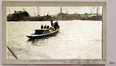
Black and white Photograph of HRH Prince of Wales leaving HMAS Brisbane at Portsmouth. 114mm x 69mm. SH 030 Ships A - B.flagstaff hill, warrnambool, shipwrecked-coast, flagstaff-hill, flagstaff-hill-maritime-museum, maritime-museum, shipwreck-coast, flagstaff-hill-maritime-village, black and white photograph -
 Orbost & District Historical Society
black and white photograph, late 19th century - early 20th century
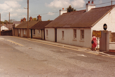
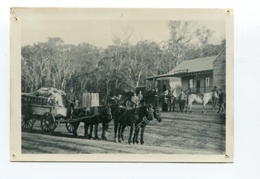
This is a photograph of Alice Swallow's hotel at Cabbage Tree. The settlement of Cabbage Tree Creek is located on the Princes Highway, 27 km east of Orbost in East Gippsland. The first white settler arrived in the valley in 1887 cutting a dray track from Marlo to the south-west. Several families cleared the alluvial flats, growing maize, peas and beans and raising pigs, cattle and sheep. Later the farmers milked cows, sending cream to Orbost. In the late 1890s, small quantities of alluvial gold were found in the creek. A school commenced classes in 1913, but enrolment was small and at times the school operated part time with several other small schools in the area. The school building served as a hall for the district. From the 1920s the Cabbage Tree Hotel catered to drivers on the improved Princes Highway. (info. from Victorian Places)This is a pictorial record of Cabbage Tree, East Gippsland in the late 20th century. It shows a building that no longer exists.A black / white photograph of a small, single - storey wooden building in a bush setting. There are people standing in front of the building with a horse and wagon nearby. In the foreground is a wagon with four horses hitched to it and the driver seated behind the horses. -
 Orbost & District Historical Society
black and white photograph, 1924
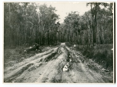
This photograph shows the main road near Bellbird, East Gippsland, in 1924. This road would have been the Princes Highway, a main thoroughfare through to New South Wales. Bellbird Creek is a small rural location between Orbost and Cann River. There was no township at Cabbage Tree at this time. The Cabbage Tree Creek township was established to support the booming timber industry of the mid 20th century. Five timber mills worked full time supporting the families that were drawn to the area's wealth of natural resources. Nestled on the banks of the Cabbage Tree Creek, the township was built by those mills to house their workers. Today although the timber mills have disappeared, some of the buildings still remain. Little now remains to remind of the saw-milling history apart from photographs and some relics - a boiler and a brick furnace. There was also a thriving agricultural community farming dairy, beef, seed beans and fresh peas and beans that were sent to the Victoria Market in Melbourne. Dairy farming still plays an essential role in the township. this is a pictorial record of the Princes Highway, the main road from East Gippsland to the New South Wales border.A large black / white photograph of a very wet and boggy bush road.on front - "Main Rd near Bellbird 1924"road princes-highway bellbird-creek-1924 -
 Orbost & District Historical Society
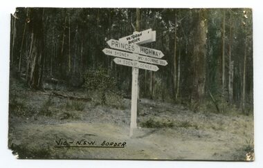
black and white photograph, first half 20th century
Prior to the sealing of the Princes Highway west of Orbost, the road surface was anything but good, even by C1917 when cars started to use the road. From Orbost the old road via Marlo to Sydenham was abandoned for the new location which traversed more rugged country via Cabbage Tree, Bell Bird and Club Terrace to Cann River, and the reason for this diversion was on account of settlements being established at Murrungowar and Club Terrace, at which latter place there was a temporary rush to obtain gold. This road was constructed by the Public Works department and a maximum grade of 1 in 19 was adopted, and as speed was not to be catered for the grade followed in and out round the spurs and gullies, resulting in a maze of turns and twists which required a good deal of skill on the part of the horse driver to negotiate." - Bairnsdale Advertiser, Friday, May 2, 1947. (More information from Newsletter February 2010)This is a pictorial record of an early road distance sign on a major highway through East Gippsland. The distances are indicated in miles, a measurement standard no longer in use.A black / white photograph postcard of the signpost at the Victorian - New South Wales border. It shows distances to Sydney and Eden on one arrow and distances to Melbourne and Genoa on another. on front - Vic - NSW Borderprinces-highway-east-gippsland road-transport road-sign -
 Orbost & District Historical Society
black and white photograph, late 19th century - early 20th century
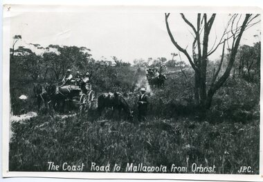
Prior to the sealing of the Princes Highway west of Orbost, the road surface was anything but good, even by C1917 when cars started to use the road. From Orbost the old road via Marlo to Sydenham was abandoned for the new location which traversed more rugged country via Cabbage Tree, Bell Bird and Club Terrace to Cann River, and the reason for this diversion was on account of settlements being established at Murrungowar and Club Terrace, at which latter place there was a temporary rush to obtain gold. This road was constructed by the Public Works department and a maximum grade of 1 in 19 was adopted, and as speed was not to be catered for the grade followed in and out round the spurs and gullies, resulting in a maze of turns and twists which required a good deal of skill on the part of the horse driver to negotiate." - Bairnsdale Advertiser, Friday, May 2, 1947. (More information from Newsletter February 2010)n the late 1800's early 1900's transporting goods by road was difficult and at times impossible because roads as thoroughfares did not exist.The means of travelling along the roads in the 1800's was by bullock wagon, horse pulled dray, pack horse or simply by foot. This road is still in use in East Gippsland as a part of many four-wheel-drive touring routes.A large black / white photograph of two horse - drawn wagons on a narrow sandy bush track. It is surrounded by scrub. There is one man standing beside a horse not harnessed to a wagon.on front - "The Coast Road to Mallacoota from Orbost JPC" -
 Orbost & District Historical Society
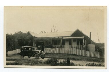
black and white photograph, 1920s -1930s
The Cabbage Tree Creek township was originally established to support the booming timber industry of the mid 20th century. Five timber mills worked full time supporting the families that were drawn to the area's wealth of natural resources. The settlement of Cabbage Tree Creek is located on the Princes Highway, 27 km east of Orbost in East Gippsland. The first white settler arrived in the valley in 1887 cutting a dray track from Marlo to the south-west. Several families cleared the alluvial flats, growing maize, peas and beans and raising pigs, cattle and sheep. Later the farmers milked cows, sending cream to Orbost. In the late 1890s, small quantities of alluvial gold were found in the creek. A school commenced classes in 1913, but enrolment was small and at times the school operated part time with several other small schools in the area. The school building served as a hall for the district. From the 1920s the Cabbage Tree Hotel catered to drivers on the improved Princes Highway. (info. from Victorian Places)This is a pictorial record of Cabbage Tree, East Gippsland in the late 20th century. It shows a building that no longer exists.A small black / white photograph of a single storey timber building. On a sign below the roof is "Cabbage Tree Hotel". The hotel is surrounded by a wooden picket fence. A man and woman are standing on either side of a motor car parked on the roadway in front of the building.on back - on label - Cabbage Tree Hotelcabbage-tree-hotel -
 Warrnambool and District Historical Society Inc.
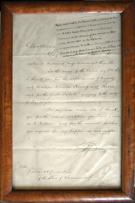
Letter - Thank you from HRH Prince Alfred to Shire of Warrnambool, Date Made: 1867
The Warrnambool Shire commenced in 1863 and it was only 4 years later that HRH Prince Alfred visited the Western District in December 1867.The visit by Prince Alfred would have been of some importance to the people of the district.Handwritten letter in brown wooden frame. Sepia coloured paper with black ink. Explanatory note on separate piece of paper in top RHC.warrnambool, warrnambool shire, warrnambool shire councillors 1867, prince alfred -
 Warrnambool and District Historical Society Inc.
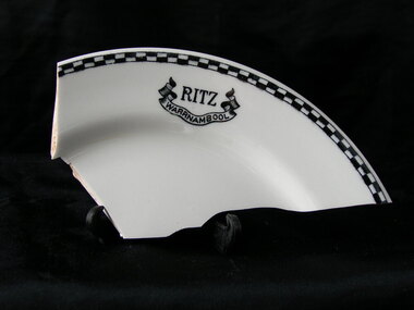
Plate, Ritz Warrnambool - fragment, Early 20th century
The Ritz was situated near the corner of Lava and Liebig St. The site was originally a hotel which traded under various names, including The Prince of Wales Dining Room, The Stork The Red Lion and later the Princess Royal after a fire in 1880 and it was delicensed in 1900. it later became the Mia mia cafe before a change to the Ritz. A fragment from Warrnambool's past.Fragment of white plate with black and white check edge and logo of Ritz with Warrnambool in banner below it.Ritz Warrnambool.warrnambool, ritz cafe warrnambool -
 Warrnambool and District Historical Society Inc.
Book, Martin Chuzzlewit - Charles Dickens, 1927
This book was a prize given to Marion Mahood in 1935 from the Clarendon Presbyterian Ladies’ College, Ballarat. Marion Mahood was a Warrnambool-born lady who spent most of her working life nursing at Prince Henry’s Hospital in Melbourne. In retirement she was active in community affairs in WarrnamboolThis book is of interest because, with the school badge embossed on the front cover, it is a good example of the type of prize awarded by private schools in Victoria in the early to mid 20th century. It also has a connection to a resident of Warrnambool, Marion Mahood.This is a dark blue leather-covered book of 796 pages. The cover has gold lettering on the spine with some gold ornamentation and the badge of Clarendon Presbyterian Ladies’ College embossed in gold on the front cover. The book has an Introduction and 54 chapters of storyline. There are several black and white illustrations scattered throughout the chapters. The book plate is printed and pasted on to the back of the front cover and handwritten material in black ink is included in the name plate. There is a slight gouge in the leather on the back cover.‘Clarendon Presbyterian Ladies’ College, Ballarat, Awarded to Marion Mahood, Prize, Sewing, Form 1VA, Janet M. McDonald, Principal, December, 1935’.clarendon presbyterian ladies’ college, ballarat, marion mahood -
 Warrnambool and District Historical Society Inc.
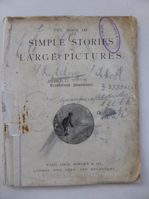
Book, Simple stories & large pictures, Late 19th century
This book was given as a prize to William Giles in the late 19th century. It came from the Skiddaw Sunday (or Sabbath) School. Skiddaw was the home of the Batterbee family and was situated on the old Princes Highway in East Warrnambool near Simpson Street today. The corner here was known as ‘Batterbees Corner’ and there is a Skiddaw Street in the locality today. George Batterbee had a ham and bacon business in Warrnambool. For 36 years his wife, Mary, conducted a Sunday School at Skiddaw (from 1882 to 1918). This Sunday School was under the auspices of St. John’s Presbyterian Church in Warrnambool. Mrs Batterbee was assisted by her daughter Florinda and other teachers. Florinda and her brother Rex were both artists of note. William Giles and his family lived on the Allansford Road. The Logan family farm was in the vicinity of where Logans Beach is today. This book, though tattered and stained, is most important as the only item we have in our collection that is associated with the Skiddaw Sunday School. Situated in a family home, this Presbyterian-sponsored Sunday School operated for 36 years under the direction of Mary Batterbee. This is a book of 32 pages with the cover and perhaps some of the pages missing. It has been stapled but the staples have been removed. The book has large print and illustrations on all the pages. The illustrations have been coloured in by hand. The first page is loose and scribbled on. The pages are very stained and torn in places. The inscription is handwritten in black ink. ‘Skiddaw S. School, Second Prize, Awarded to William Giles for diligence in class, S. Logan, Teacher’. skiddaw, east warrnambool, batterbee family, giles family, logan family, history of warrnambool -
 Warrnambool and District Historical Society Inc.
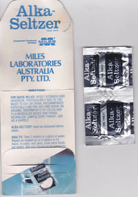
Mixed media - Travellers Aid Bag, Travellers Aid bag & Contents, C 1980
These items were given to clients of the Mid City Motel (probably the one in Ballarat ). The Mid City Motel company was formed in 1963 by a syndicate with the motel in Raglan Parade, Warrnambool. It was later sold with the company liquidated in 1982. The expansion from Warrnambool to Ballarat occurred in 1970 with a building in Doveton Street North, Ballarat. Items such as the sewing kit and shower cap are still given out as promotional material in many motels today. These items are of little importance but are examples of the promotional activities of the motel/tourism scene 30 or so years ago. They may be useful for display.This is a small plastic bag containing a paper sewing kit and a paper folder containing two Alka-Seltser tablets. The sewing kit is red and white and the Alka Seltzer packet is mostly blue. The three items come from the Mid-City Motel and are intended to be kept in a car. Plastic Bag: Mid City Motels, Princes Highway, Warrnambool, 055 62 8026, Doveton Street, Ballarat, 053 31 1222, Travellers Aid Bag for your car with Sewing Kit, Alka Seltzer, Shoe Shine, Shower Cap, Have a Nice Day, Ballarat City Map.warrnambool, mid city motel, tourism -
 Warrnambool and District Historical Society Inc.
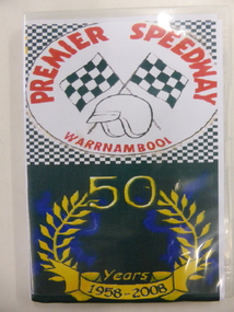
DVD, Premier Speedway
The Warrnambool Hot Rod Club was formed in 1958 at the Warrnambool racecourse. In 1969 the Club transferred to a site on the Princes Highway. Today the Club is the Premier Speedway Club and the major annual event is the Grand Annual Sprintcar Classic. This DVD was produced to celebrate the 50th Anniversary of the Warrnambool Premier Speedway Club. It is retained as a souvenir of that anniversaryThis is a DVD with two discs contained in a plastic folder. The cover of the folder is multi coloured and contains photographs of speedway vehicles, an image of two chequered flags, a helmet and a laurel wreath.PREMIER SPEEDWAY WARRNAMBOOL 50 Years 1958-2008premier speedway warrnambool, car racing warrnambool, history of warrnambool -
 Warrnambool and District Historical Society Inc.
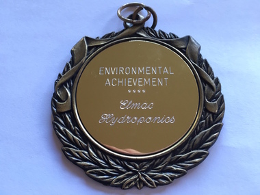
Medallion, Trophy Environmental achievement, 2000
This is a medallion awarded in 2000 by Powercor Warrnambool to Elmac Hydroponics. Powercor Australia, founded in 1994, is an electrical distribution company operating in the Western District of Victoria and the western suburbs of Melbourne. Powercor Warrnambool, like other Powercor organizations, is involved in giving Business Excellence Awards annually to businesses in its area of supply. In 2014 there were 15 awards for Business Excellence. Elmac Hydroponics was a business growing and supplying organically-produced tomatoes from 1997 to 2004. It was situated at Mount Pleasant, Princes Highway, Allansford, Victoria. The business was operated by Graeme and Barbara McLeod and Keith and Leonie Ellerton. Hydroponics is a system of growing plants without soil, using a nutrient solution. Elmac Hydroponics had a 2,000 square metre greenhouse with 10,000 growing points. This is a significant medallion, showing the award given to a small business in the Warrnambool area and indicating its achievements in the environmental area. Elmac was an industry leader in in implementing an ‘Autopot’ hydroponic system which is aimed at reducing nutrient and waste water to zero. Elmac was also a finalist in the Ericsson 2002 Innovation Awards.This is a gilt metal medallion, oval-shaped, with an ornamental edging and a shield-shaped design on one side and a circular design on the other. The top has two metal rings for attachment to a chain or wall hook. On one side: ‘Environmental Achievement, Elmac Hydroponics’ On obverse side: ‘Powercor Warrnambool Region Business Achievement Awards, 2000’ elmac hydroponics, powercor business awards, warrnambool -
 Warrnambool and District Historical Society Inc.
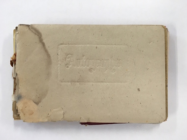
Booklet, Autograph Book, Late 1930s
According to the front page this autograph book belonged to Patricia Spencer of Spencer Street, Dartmoor. Dartmoor is a small settlement on the Princes Highway between Heywood and the South Australian border. It was first settled in the late 1850s and the main industry is the processing of timber from the surrounding pine plantations. Patricia Spencer attended Warrnambool High School in the late1930s and this album contains a number of entries from Warrnambool High School in 1938. It also has a page of eleven signatures of the Head Master, George Langley and other teachers from Warrnambool High School. There are also entries from people from Mortlake and Panmure and other entries with the person’s address not indicated. Autograph books such as this one were commonly owned by young people in the 19th and 20th centuries (up to about 1950) and were very popular with young girls.This album, although incomplete and tattered, is of interest because it is a good example of the social custom, more popular a couple of generations back than it is today, of young people owning and obtaining signatures and verses from their friends and acquaintances. It is also important because it contains signatures of Warrnambool High School teachers in 1938 and there are other entries of interest. This is a small autograph album that was originally bound with a cardboard cover with red leather backing but now has no front cover and only part of the back cover. The pages are all loose and the front section (buff-coloured) has a cardboard piece with felt padding. The pages are coloured in a variety of pastel tones and there are many handwritten entries of verses and signatures, with several from the ‘B’ Form, 1938, of ‘W.H.S. (Warrnambool High School). The album appears to have belonged to Patricia Spencer from Dartmoor. Some of the pages are torn and stained. At the back there are remnants of a sketch of an Asian scene and a letter to ‘Pat’ for her birthday. ‘Autographs’ ‘Patricia Spencer, Spencer Street, Dartmoor’ autograph albums, patricia spencer, warrnambool -
 Warrnambool and District Historical Society Inc.
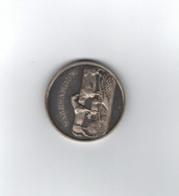
Medal, Villiers and Heytesbury Agricultural Association (Daniel Hourigan 1877), C 1877
This medal was awarded at the Villiers and Heytesbury Agricultural Association Annual Show to Daniel Hourigan in 1877 for his yearling colt by 'Prince of the Isles'. The formation of the Villiers and Heytesbury Agricultural Association arose out of a meeting at Woodford in 1853 and the first Show was held in Warrnambool in 1855 on a green bound by Fairy, Henna and Koroit Streets. It was held there until 1875 when it moved to the present Warrnambool Showgrounds in Koroit Street. At the 37th Annual Show in 1890 Warrnambool held its first Grand National Show, a title granted by the Chamber of Agriculture in Victoria. The Villiers and Heytesbury Agricultural Association became known as the Warrnambool Agricultural Show in 1911. Daniel Hourigan was a farmer, road contractor, poundkeeper and auditor who lived in the Tower Hill area in the 19th century. This medal is of considerable interest as it is a memento of the Villiers and Heytesbury Agricultural Association Annual Show in the 19th century. Annual Agricultural Shows have been an important feature of agricultural life in Victoria since the early days of European settlement and a feature of agricultural life in the Warrnambool district since the 1850s. The medal is also of great interest because it was awarded to Daniel Hourigan, a prominent settler in the Warrnambool district in the 19th century. .1 Circular silver disc with image of horse, bull, sheep, wheat sheaf and plough on the reverse with script around edge of obverse with awardees details engraved in the centre. Edge of the medal is plain. .2 Square maroon leather case with small metal clasp and hinge. Lined on the interior with blue velvet and cream silk.Obverse :" Warrnambool" engraved above image of cattle. W J Taylor London Reverse : Villiers & Heytesbury Agricultural Association in low relief around the edge. 1st prize awarded to Daniel Houriganfor yearling colt , "Prince of the Isles Annual Show 10th October 1877.warrnambool, villiers and heytesbury, daniel hourigan, prince of the isles, 1877, villiers & heytesbury agricultural show -
 Warrnambool and District Historical Society Inc.
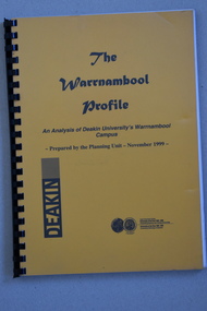
Booklet Lettering Book, Deakin University Planning Unit, The Warrnambool Profile – An Analysis of Deakin University’s Warrnambool Campus, 1999
This booklet was prepared in 1999 by the Planning Unit of Deakin University. It gives current data on the campus and projections and suggestions for the future. The Warrnambool Campus of Deakin University was established in 1990 after a merger with the Warrnambool Institute of Advanced Education which was already on the site that the university still occupies. This is Sherwood Park, a 94 hectare site on the Princes Highway, five kilometres from Warrnambool.This booklet is of some interest as it contains information on the Warrnambool Campus of Deakin University ten years after it was first established. This is a soft cover booklet of 179 pages. It has an orange front cover and a black back cover with black printing and a plastic over-sheet. The booklet has printed information, tables and graphs. It has black plastic spiral binding. deakin university, warrnambool campus -
 Warrnambool and District Historical Society Inc.
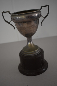
Trophy, 4/19 L H Camp 1938, 1930s
This is a trophy awarded at a camp of the 4/19 Light Horse Regiment. This regiment appeared to have been based in the Corangamite region of the Western District and included regiment members from Warrnambool. It is not known exactly what type of competition was an ‘Officers Flutter’. Light Horse regiments were cavalry regiments that were established at the time of the Crimean War in the 1860s. During the First World War the 4th Light Horse served with distinction in France, Gallipoli and Palestine. In 1948 the 17th Prince of Wales Light Horse, the 19th Yarrowee Light Horse and the 4th (ex 20th ) Corangamite Light Horse amalgamated to form a revived 4/19 Light Horse. This regiment kept alive the tradition of the original Light Horse units, becoming part of the Australian Army Reserve and members served in Vietnam and East Timor. This cup is of interest as an example of the trophies awarded for competition at a Light Horse regiment camp in the 1930s. This is a metal cup (silver amalgam)) with two side handles and a narrow stem attached to a silver base. The cup is attached to a brown Bakelite stand. The inside of the cup has some white paint streaks and the cup itself is much stained and pock-marked. ‘Westminster’ 4/19 L.H. Camp 1938 Officers Flutter light horse regiments. warrnambool district, history of warrnambool -
 Warrnambool and District Historical Society Inc.
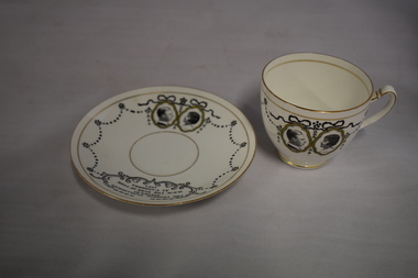
China, The Federation Parliament HRH Duke of York, 1920s
This cup and saucer set was issued as a souvenir of the opening of the Federal Parliament in Canberra in 1927. The building was opened by Prince Albert, the Duke of York who was accompanied by Elizabeth, the Duchess of York. The Duke of York later became King George VI of England. The colonies in Australia became Federated States in 1901 and from that date to 1927 the Australian Federal Parliament sat in Melbourne. When Canberra became the capital of Australia a Parliament House building was erected at a cost of £600,000 but it is now known as Old Parliament House as the present Parliament House was opened in 1988. This cup and saucer set is of interest as a memento of an important event in Australia’s history – the creation of a capital city and the opening of the first Federal Parliament House. It will be useful for display. This is a white china cup and saucer set. Both the cup and saucer have two gold bands around the rims and are decorated with black ornamentation and the portraits of the Duke and Duchess of York contained within gold oval patterns. There is also black lettering on both objects. The name of the maker is printed on the bottoms of both objects. On both objects: ‘The Federal Parliament opened by H.R.H. The Duke of York at Canberra 1927’ ‘Foley China E.B. & Co. Made in England’ opening of federal parliament 1927, history of warrnambool -
 Warrnambool and District Historical Society Inc.
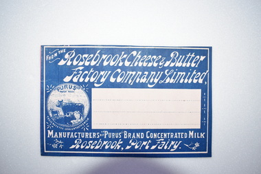
Label, Rosebrook Cheese and Butter Factory, Early 20th century
The Rosebrook Cheese and Butter Factory was opened in November 1888 by Messrs Lydiard &T F Rutledge & was a cooperative factory managed by Mr. Goldie. It operated out of the former Rosebrook Flour Mill which was built on the banks of the Moyne River near the Rosebrook bridge in the late 1840s. In 1896 the factory commenced the production of the condensation of milk. The company closed in 1911. The building and machinery were sold in 1917. Rosebrook is situated about 20 kilometres from Warrnambool on the Princes Highway. This label is of some local significance as the Rosebrook Cheese and Butter factory operated for 30 years Rectangular dark blue and white label featuring text and a trade mark. The latter is circular with three cows pictured. There are decorations of flowers and leaves. The central area of the label is white with three lines. The label is adhered to a piece of pink card.FROM THE Rosebrook Cheese & Butter Factory Company Limited, MANUFACTURERS OF "PURUS BRAND CONCENTRATED MILK Rosebrook, Port Fairy. "PURUS" TRADE MARK FOR CONCENTRATED MILKrosebrook, cheese and butter, concentrated milk, lydiard, rosebrook butter factory