Showing 2842 items
matching wests road
-
 Kew Historical Society Inc
Photograph - Kew Main Drain, 1984
... just west of Burke Road at Kew High School before discharging... Drain; Balwyn Drain & Glass Creek converge in Kew East just west ...'Kew, Kew East, Balwyn & Balwyn North are located approximately 7km north east of Melbourne. Four main stormwater drains service the area flowing from south to north. Three of the drains: Deepdene Drain; Balwyn Drain & Glass Creek converge in Kew East just west of Burke Road at Kew High School before discharging into the Yarra River. The fourth drain, Kew Main Drain connects directly with the Yarra River to the West of Glass Creek.' The Kew Main Drain is a barrel drain that was created in the 1930s, and follows the route of the former Connor's Creek from the vicinity of Genazzano FCJ College to the Yarra River in East KewImportant and verifiable evidence of the construction methods used by the Melbourne & Metropolitan Board of Works in building the Kew Main Drain, before its reconstruction in c.1985.Original print colour positive photograph of the Kew Main Drain, provided on 14/12.84 to the Chief Engineer of the City of Kew, Ian Poulter, by the Supervising Engineer (Works), Southern and Eastern Drainage, Melbourne & Metropolitan Board of Works. The record includes an image of the reverse as well as the donation document from the MMBW."A84/1855-9 / 750mm council drain looking D/S [down stream] and across Parkhill Road. To be replaced with 1200 mm R.C.P. [reinforced concrete pipe] as part of MMBW Kew Main Drain reconstruction works"kew main drain, stormwater drains -- kew (vic.), connor's creek -- kew (vic.) -
 Kew Historical Society Inc
Photograph - Kew Main Drain, 1984
... just west of Burke Road at Kew High School before discharging... Drain; Balwyn Drain & Glass Creek converge in Kew East just west ...'Kew, Kew East, Balwyn & Balwyn North are located approximately 7km north east of Melbourne. Four main stormwater drains service the area flowing from south to north. Three of the drains: Deepdene Drain; Balwyn Drain & Glass Creek converge in Kew East just west of Burke Road at Kew High School before discharging into the Yarra River. The fourth drain, Kew Main Drain connects directly with the Yarra River to the West of Glass Creek.' The Kew Main Drain is a barrel drain that was created in the 1930s, and follows the route of the former Connor's Creek from the vicinity of Genazzano FCJ College to the Yarra River in East KewImportant and verifiable evidence of the construction methods used by the Melbourne & Metropolitan Board of Works in building the Kew Main Drain, before its reconstruction in c.1985.Original print colour positive photograph of the Kew Main Drain, provided on 14/12.84 to the Chief Engineer of the City of Kew, Ian Poulter, by the Supervising Engineer (Works), Southern and Eastern Drainage, Melbourne & Metropolitan Board of Works. The record includes an image of the reverse as well as the donation document from the MMBW."A84/1855-10 / 750mm council drain looking U/S [up stream] from Parkhill Road, Kew."kew main drain, stormwater drains -- kew (vic.), connor's creek -- kew (vic.) -
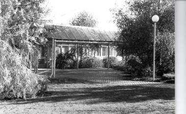 Hume City Civic Collection
Photograph, Shire of Bulla Offices, 1966
... by Wester Water and Vic Roads.... by Wester Water and Vic Roads. Apart from the former Shire of Bulla ...Before the Shire of Bulla built permanent offices in Macedon Street, the council used to meet in the Memorial Hall and had rooms there to conduct regular business. Some cottages were demolished to build the new offices which were completed and opened in 1966. Over the years as the shire's population increased, further additions were added. After Sunbury became part of Hume City Council, the former council building was occupied by Wester Water and Vic Roads.Apart from the former Shire of Bulla Roads Board office built in Sunbury in the 1860s, the 1966 building is the first council building to be built in Sunbury.A black and white photograph of a single storey office building and the surrounding garden. There is a light pole in the foreground.shire of bulla, council offices -
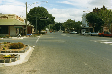 Charlton Golden Grains Museum Inc
Photograph, Pollard, Jenny, High Street Charlton 1989, c.1989
... of Armstrong Street looking west. Garden beds in lower LH, road signs... looking west. Garden beds in lower LH, road signs pointing to St ...High Street Charlton streetscape. Shows Sweatman's North Central Panel Beaters (formerly Charlton Motors Pty Ltd garage), Heather's Choice Gift Shop (in the former Bilton/Dillon building built 1889), Westpac Bank, War Memorial (built 1923)Colour photograph of High St Charlton taken near the corner of Armstrong Street looking west. Garden beds in lower LH, road signs pointing to St Arnaud and to Mildura and Donald. North Central Panel Beaters on corner. Orange car driving west, person crossing the road, man standing near white ute in front of Westpac bank on RH side of photo. Heather's Choice sign on side of building. War Memorial at the end of the road.sweatmans, north central panel beaters, heather's gift shop, bilton building, westpac, war memorial, charlton, business, industry -
 Kiewa Valley Historical Society
Photograph of Kiewa Valley Panorama, Kiewa Valley from No. 5 Road, Before 1945
... . The No. 5 Road, from where the photograph was taken, is the road..., from where the photograph was taken, is the road to West Kiewa ...In 1943 a camp for workmen was erected and a commencement made with the erection of plant storage and workshop buildings in the new township of Mt. Beauty. The photograph was probably taken after the completion of these buildings. There is no sign of construction of the town itself. In the latter part of 1945 work was commenced on the Mt. Beauty township area with a medical centre, general trading store and some houses under construction. The No. 5 Road, from where the photograph was taken, is the road to West Kiewa Power Station and Big Hill Scenic Lookout.Is an excellent view of the Kiewa Valley before there was little work undertaken to establish the town of Mt. Beauty. Farming was well established with the evidence of huge areas of cleared land. The junction of the East and West Kiewa Rivers can be clearly seen. The first Workmen's camp is near the river and some workshop buildings can also be seen. Black and white photograph of the Kiewa Valley, looking North.Handwritten on the back of photograph "Kiewa Valley from No. 5 Road".kiewa valley, camp, buildings, mt. beauty -
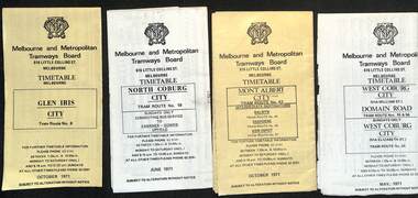 Melbourne Tram Museum
Ephemera - Timetable, Melbourne & Metropolitan Tramways Board (MMTB), MMTB Tram timetables, set of 12, 1971
... - West Coburg - Domain Road and West Coburg City on Sundays... - West Coburg - Domain Road and West Coburg City on Sundays ...Timetables for specific routes, day of week giving information on tram times at specific time points, route map, sections and fares and organisation address - 616 Little Collins St. Melbourne. 1 - Glen Iris - City route 6 - Oct. 1971 2 - North Coburg with connecting bus to Fawkner and Gowrie - Upfield on Sundays - June 1971 3 - Mont Albert - City - routes 42, 44, 45, 37 - Oct. 1971 4 - West Coburg - Domain Road and West Coburg City on Sundays - routes 55, 56 and 68 - May 1971 5 - Essendon Aerodrome - City route 59 - June 1971 6 - East Brighton - City - routes 64, 65, 62, 61 - Oct. 1971 7 - Carnegie - City - routes 67, route 66 - Oct. 1971 8 - Wattle Park - City route 70, route 71 and route 76 - Oct. 1971 9 - Camberwell - City - route 72, route 73 - Oct. 1971 10 - Prahran - City, North Richmond -Prahran - St Kilda Beach, routes 77, 78 and 79 - Oct. 1971 11 - East Preston - City and East Brunswick - City - routes 88, 89, 90. 96 and 97 - Oct. 1971 12 - ditto for Sundays printed on green paper. 13 - Route 8, Toorak, Oct. 1971-*Yields information about 1971 MMTB timetables.Set of 12 1971 MMTB Tram timetables, folded sheets.trams, tramways, timetables, mont albert, route 42, route 6, route 19, upfield, route 44, route 45, route 37, route 55, route 56, route 68, route 59, route 64, route 65, route 62, route 61, route 67, route 66, route 70, route 71, route 76, route 72, route 73, route 77, route 78, route 79, route 88, route 90, route 96, route 97, route 8 -
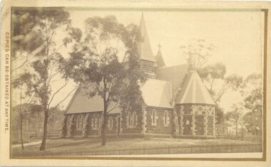 Bacchus Marsh & District Historical Society
Photograph, Holy Trinity Church Bacchus Marsh 1883
... constructed Anglican Holy Trinity Church in Gisborne Road, Bacchus... the recently constructed Anglican Holy Trinity Church in Gisborne Road ...The Holy Trinity Anglican Church in this location was first opened in 1877. An earlier nearby prefabricated Church building known as the 'Iron Church' had served as the Anglican place of worship in Bacchus Marsh from around 1855 until 1877. The 1877 sandstone Church with a slate roof was intended as a permanent structure for Anglican worship in Bacchus Marsh and still stands in 2024 and continues to function as an Anglican Church. The building was designed by Frederick Wyatt and is described as early English Gothic in style. It was opened on 5 June 1877 by Bishop Moorhouse of Melbourne. The sandstone was acquired from Grant's quarry at Maddingley.Small sepia unframed photograph on card with gold border framing photograph. Housed in the Jeremeas Family Album, which contains photographs of Bacchus Marsh and District in 1883 by Stevenson and McNicoll. The photograph depicts the recently constructed Anglican Holy Trinity Church in Gisborne Road, Bacchus Marsh. The view of the building is from Gisborne Road looking west. From this angle the rear and southern side of the building can be seen. A picket fence along the entrance to the Church grounds can be seen in the foreground.On the front: Stevenson & McNicoll. Photo. 108 Elizabeth St. Melbourne. COPIES CAN BE OBTAINED AT ANY TIME. On the back: LIGHT & TRUTH inscribed on a banner surmounted by a representation of the rising sun. Copies of this Portrait can be had at any time by sending the Name and Post Office Money Order or Stamps for the amount of order to STEVENSON & McNICOLL LATE BENSON & STEVENSON, Photographers. 108 Elizabeth Street, MELBOURNE churches bacchus marsh, holy trinity anglican church bacchus marsh, holy trinity church of england bacchus marsh, stevenson and mcnicoll 1883 photographs of bacchus marsh and district -
 Melbourne Tram Museum
Album - Robert Thomson Slide Collection, "Melbourne 1970 - 1979"
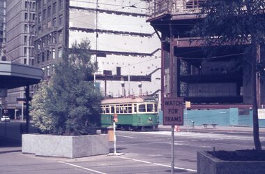
... , tram 1065 - "West Maribyrnong" - route 57 RT265 St Kilda Road..., tram 1065 - "West Maribyrnong" - route 57 RT265 St Kilda Road ...Photo - see pdf file for further information. Number Brief Description RT264 Elizabeth St, at Bourke St, with the construction of the State Savings Bank building (State Bank Galleria) underway. Bourke St Mall also under construction, Note tram warning Sign, tram 1065 - "West Maribyrnong" - route 57 RT265 St Kilda Road, tram 778 - "City" -route 59 RT266 St Kilda Road, tram 569 - "East Malvern Darling Road" -route 3 & tram 819 - "Glen Iris" - route 6 RT267 Swanston St, tram 538 - "City" - route 2A RT268 St Kilda Junction, tram 924 - "City" - route 5 RT269 St Kilda jct, tram 280 - "St Kilda Beach" - route 15 RT270 St Kilda Road, tram 507 - "City" - route 72 RT271 Nicholson St Gertrude St - tram7 - "East Preston Tyler St" - route 88 RT272 West Coburg, tram 778 - "Domain Rd" - route 55 RT273 Wests Road, tram 750 - "Moonee Ponds" - route 22 RT274 St Kilda Rd, tram 8 - "Special" RT275 Nicholson St Victoria Pde, tram 10W - "Special" RT276 L Class Queens way, "City" - route 54 RT277 Bourke St at Spring St, tram 998 - "East Coburg" - route 88 RT278 Nicholson St MMTB Bus, bus 562 - "Garden City via Port Melb" - route 2 RT279 Church St Burwood Rd Jct, tram 9 - "Special" RT280 Riversdale Rd at Camberwell Depot - "Burwood" - route 74 RT281 Balaclava Junction - tram 819 - "Kew Cotham Rd" - route 69 RT282 East Brunswick Terminus, tram 4 - "City Spencer St" - route 96 RT283 Peel St - tram 927 - "Special" RT284 East Brighton Terminus - tram 563 & tram 926 - "City" - route 64 RT285 Dandenong Rd Hawthorn Rd, tram 346 - route 64 RT286 Bourke St at Spring St, tram 34 - "North Fitzroy Park St" - route 97 RT287 Route 69 Terminus St Kilda - tram 369 - "Kew Cotham rd" - route 69 RT288 Route 78 Terminus St Kilda, tram 498 - "North Richmond" - route 78 RT289 Track relay, Fitzroy St, St Kilda RT290 Fitzroy St, St Kilda Demonstrates the work of Robert Thomson in photography, collection and/or production of slidesAssembled album in a black presentation folder of 27 colour slides, collected or produced by Robert Thomson. All photographs have been scanned and placed on the Museum's G drive. A list of all photographs with details has been compiled. melbourne, tramways, trams, track construction, elizabeth st -
 Ballarat Tramway Museum
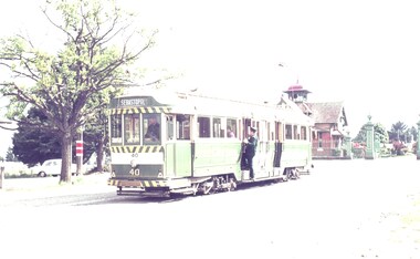
Slide - 35mm slide/s - set of 2, Robert Thomson, 27-4-1965?
... on the west side of the road. The conductor is boarding and the driver... on the west side of the road. The conductor is boarding and the driver ...Yields information about tram 40, the Lydiard St terminus tram stop and the Sebastopol tram terminus and tram 40.Agfa blue/white mount, colour slide of tram 40 at both the Lydiard St North and Sebastopol terminus. Both over exposed photos. .1 - No. 40 early in the morning given the sun position, shows the cemetery gates and the tram stop sign on the west side of the road. The conductor is boarding and the driver is in the cabin. Tram has the destination of Sebastopol. .2 - has the tram side on, with the Royal Mail Hotel in the background. Slide not dated, but based on slide mount and views and Reg item 7483, likely to be 27-4-1965tramways, trams, lydiard st north, sebastopol, tram stops, tram 40 -
 Melbourne Tram Museum
Photograph - Illustration/s, c1979
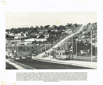
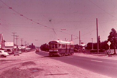
... a calendar sheet - of Burwood Highway, looking east just west...Melbourne Tram Museum 8 Wallen Road Hawthorn melbourne ...Illustration - black and white - possibly cut from a calendar sheet - of Burwood Highway, looking east just west of the Elgar Road intersection. Shows the relatively new track and Z25 inbound to Spencer St. Has a golden fleece service station on the left hand side. Shows the road arrangements at the time. Caption to illustration notes first new extension since 1956, opening date, reserved track and that Z class trams are used on it. One of the 1969 Metropolitan Transport Committee recommendations. Two copies held.trams, tramways, burwood highway, burwood, track construction, mmtb, z class, tram 25 -
 Ballarat Tramway Museum
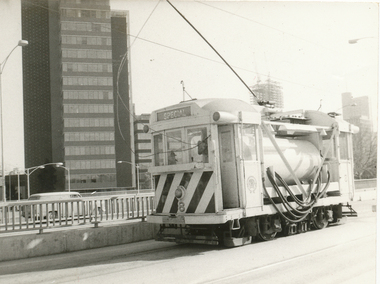
Photograph - Black & White Photograph/s - set of 3, Ellen Butland, early 1970's?
... - Dandenong Road, about to use the crossover just to the west... to the west of Glenferrie Road .3 - using the crossing. Has ...Set of three black and white prints of MMTB Scrubber No. 8 early 1970's. .1 - Arts Centre area, St Kilda Road .2 - Dandenong Road, about to use the crossover just to the west of Glenferrie Road .3 - using the crossing. Has the Hoyts picture theatre on the corner of Glenferrie and Dandenong Roads in the background. On Agfa paper. Photo by E. G. Butland - Ron Scholten - provided a written note re Ellen Butland - in with worksheet - 5th women driver in Melbourne, worked from Kew, now lives in NZ and drove buses in Auckland. See Donated by Ron Scholten to BTM 11/2005 See Destination City - renumbering of No. 8 to 8W took place during 1975.1 - "E.G. Butland" stamped in black ink on rear. .2 - as above, "Wattletree Road" stamped in public in three places, along with address blacked out and the words "please return to" in pencil and in the top left hand corner "No.8 Victoria Pde" in pencil. .3 - "E.G. Butland" stamped in black ink on rear., "D. Menzies / 237 Wattletree Road, Malvern Vic. 3144."tramways, trams, scrubber tram, dandenong road, st kilda road, tram 8, tram 8w -
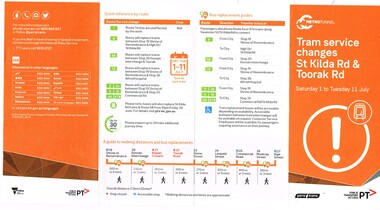 Melbourne Tram Museum
Pamphlet, Public Transport Victoria (PTV), "Tram service changes St Kilda Rd & Toorak Rd", Jun. 2017
... /2017 and 11/7/2017 to connect route 8 at Toorak Road West... route 8 at Toorak Road West into St Kilda road the closure ....1 - Pamphlet - four fold - DL side four colour printed on off-white paper, titled "Tram service changes St Kilda Rd & Toorak Rd", advising intending passengers of the work between 1/7/2017 and 11/7/2017 to connect route 8 at Toorak Road West into St Kilda road the closure of the route via Park and Domain Road. Has a map, list of service changes, bus replacement guides and contact information. Has the logos of Metro Tunnel, Yarra Trams and PTV. .2 Pamphlet, printed and cut for use in trams around passenger hanging rails, titled "St Kilda Rd Tram and Bus service changes - Saturday 1 to Tuesday 11 July" - details bus replacement services and tram stops. Related to the main pamphlet - see image Set of five digital images taken at stop 25, Park St advising of the route diversion, replacement services and stop closure and two protest posters on fences nearby the stop about the Metro Tunnel project trucks using the local streets and the closure of the Park St / Domain Road tram line. .2 Pamphlet, printed and cut for use in trams around passenger hanging rails, titled "St Kilda Rd Tram and Bus service changes - Saturday 1 to Tuesday 11 July" - details bus replacement services and tram stops. Related to the main pamphlet.trams, tramways, park st, domain junction, metro tunnel, toorak rd, st kilda rd, tramway construction -
 Eltham District Historical Society Inc
Photograph - Aerial Photograph, Landata, Research, Vic, Apr. 1972
... to east and Parsons Road to west. Historic Aerial Imagery Source... to east and Parsons Road to west. Historic Aerial Imagery Source ...Centred on present day Maroong Drive, Research bounded by Allendale Road to north, Thompson Crescent to south, Eltham College to east and Parsons Road to west. Historic Aerial Imagery Source: Landata.vic.gov.au Aerial Photo Details: Project No :985 Project : MELBOURNE 1972 Run : 26 Frame : 193 Date : 04/1972 Film Type : B/W Camera : RC10 Flying Height : 5700 Scale : 9600 Film Number : 2636 GDA2020 : 37°42'04"S, 145°10'33"E MGA2020 : 339187, 5825794 (55) Melways : 22 F1 (ed. 42)aerial photo, neil webster collection, 1972-04, allendale road, eltham, eltham barrel, eltham college, maroong drive, melway 22f1, parsons road, research (vic.), thompson crescent -
 Eltham District Historical Society Inc
Photograph - Aerial Photograph, Landata, Lower Plenty, Feb. 1956
... to east and Bonds Road to west. Historic Aerial Imagery Source... to east and Bonds Road to west. Historic Aerial Imagery Source ...Centred on present day 217 Old Eltham Road, Lower Plenty bounded by Pitt Street to north, Yarra River to south, Main Road to east and Bonds Road to west. Historic Aerial Imagery Source: Landata.vic.gov.au Aerial Photo Details: Project No :250 Project : MELBOURNE OUTER SUBURBS PROJECT Run : 17 Frame : 116 Date : 02/1956 Film Type : B/W Camera : EAG9 Flying Height : 10000 Scale : 12000 Film Number : 1176 GDA2020 : 37°43'58"S, 145°07'49"E MGA2020 : 335237, 5822186 (55) Melways : 21 E10 (ed. 42)aerial photo, 1956-02, neil webster collection, eltham, main road, bonds road, elham, lower plenty, melway 21e10, pitt street, yarra river -
 Eltham District Historical Society Inc
Photograph - Aerial Photograph, Landata, Research, Vic, Feb. 1956
... to south, Bells Hill Road to east and Eucalyptus Road to west... to south, Bells Hill Road to east and Eucalyptus Road to west ...Centred on present day Thompson Crescent, Research bounded by Maroondah Aqueduct to north, Thompson Crescent and Nyora Road to south, Bells Hill Road to east and Eucalyptus Road to west Historic Aerial Imagery Source: Landata.vic.gov.au Aerial Photo Details: Project No :250 Project : MELBOURNE OUTER SUBURBS PROJECT Run : 19 Frame : 6 Date : 02/1956 Film Type : B/W Camera : EAG9 Flying Height : 10000 Scale : 12000 Film Number : 1176 GDA2020 : 37°42'38"S, 145°11'02"E MGA2020 : 339927, 5824736 (55) Melways : 22 H4 (ed. 42)aerial photo, 1956-02, neil webster collection, bells hill road, eltham, eucalyptus road, maroondah aqueduct, melway 22h4, nyora road, research (vic.), thompson crescent -
 Eltham District Historical Society Inc
Photograph - Aerial Photograph, Landata, Eltham, Vic, Apr. 1963
... to east and Reichelt Avenue and Rattray Road to west. Historic... to east and Reichelt Avenue and Rattray Road to west. Historic ...Centred on present day Eltham Ridge, Bolton Street, Eltham bounded by Elsa Court to north, Main Road to south, Bible Street to east and Reichelt Avenue and Rattray Road to west. Historic Aerial Imagery Source: Landata.vic.gov.au Aerial Photo Details: Project No :486 Project : MELBOURNE (1963) PROJECT Run : 6 Frame : 124 Date : 04/1963 Film Type : B/W Camera : RC8 Flying Height : 5100 Scale : 9600 Film Number : 1805 GDA2020 : 37°43'12"S, 145°08'16"E MGA2020 : 335876, 5823604 (55) Melways : 21 G6 (ed. 42)aerial photo, neil webster collection, 1963-04, bible street, bolton street, eltham, eltham ridge, main road, montmorency, rattray road, reichelt avenue -
 Eltham District Historical Society Inc
Photograph - Aerial Photograph, Landata, Eltham, Vic, Apr. 1972
... and Raglan Road to east and Zig Zag Road to west. Historic Aerial... and Raglan Road to east and Zig Zag Road to west. Historic Aerial ...Centred on present day Parsons Road, Eltham bounded by Allendale Road to north, Frank Street to south, Research Shops and Raglan Road to east and Zig Zag Road to west. Historic Aerial Imagery Source: Landata.vic.gov.au Aerial Photo Details: Project No :985 Project : MELBOURNE 1972 Run : 26 Frame : 192 Date : 04/1972 Film Type : B/W Camera : RC10 Flying Height : 5700 Scale : 9600 Film Number : 2636 GDA2020 : 37°42'00"S, 145°09'59"E MGA2020 : 338360, 5825897 (55) Melways : 22 D1 (ed. 42)aerial photo, neil webster collection, 1972-04, allendale road, eltham, zig zag road, frank street, melway 22d1, parsons road, raglan road, research (vic.), research shops, eltham barrel -
 Whitehorse Historical Society Inc.
Photograph, Site of Barnard's Corner Store
... Corner Store (2 copies) Boronia Road and Canterbury Road, Vermont... was on the south-west corner of Canterbury Road and L.L. Vale Road (Boronia ...Laser Print of black and white photo of Site of Barnard's Corner Store (2 copies) Boronia Road and Canterbury Road, Vermont. (Mounted) Barnard's Store was on the south-west corner of Canterbury Road and L.L. Vale Road (Boronia Road) Vermont. The old store was run by Miss Barnard. Mr Barnard had a Farriers Shop at the back of the store. The white gates on back centre of photograph in Canterbury Road is entrance to Uplands, home of Edward Bishop and Dr. Stephens. White fence on right hand side of photograph is entrance to home of Mr. & Mrs. Tilson who was a market gardener and orchardist.barnards corner store, uplands, vermont, stephens, dr., tilson, mr., tilson mrs, bishop, edward -
 Melbourne Tram Museum
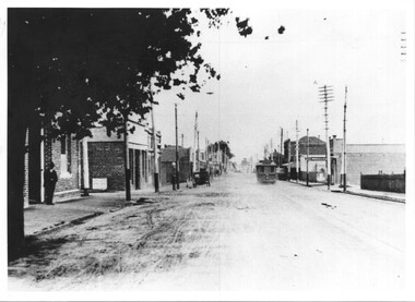
Photograph - Set of 2 Block Mounted Photographs, Surrey Hill Neighbourhood Centre, c1920
... in the top right hand corner of Whitehorse Road looking west near... of Whitehorse Road looking west near Yerrin St, c1920. Shows the single ...Photograph - mounted onto a heavy card, numbered 65-576 in the top right hand corner of Whitehorse Road looking west near Yerrin St, c1920. Shows the single line that was duplicated in 1923. Notes that the image is courtesy of the TMSV. See image i2 for the actual photograph. 4673.1 - loose print of the photograph with the words on the rear: "Melbourne / Whitehorse Road, Balwyn / Single Truck tram on original single track line. Probably about 1920 or so (Opened 30/9/16 and duplicated 14/2/23 from Burke Rd to Talbot Ave)On rear in ink "Reproduced C No. 1450, ?? Original photo now have Negative" and the "Surrey Hill Neighbourhood Centre" stamp. On the front under the number "Original Neg No. 2106"trams, tramways, whitehorse road, balwyn -
 Eltham District Historical Society Inc
Photograph - Aerial Photograph, Landata, Eltham, Vic, Jan. 1951
... Centred on Allison Crecent Reserve, Sherbrook Road... melbourne Centred on Allison Crecent Reserve, Sherbrook Road ...Centred on Allison Crecent Reserve, Sherbrook Road and Scenic Crescent, Eltham bounded by Allendale Road to north, Dudley Street to south, Zig Zag Road to east and St Helena Road to west. Historic Aerial Imagery Source: Landata.vic.gov.au Aerial Photo Details: Project No :65 Project : MELBOURNE AND METROPOLITAN PROJECT NO. 2 Run : 7 Frame : 10 Date : 01/1951 Film Type : B/W Camera : EAG9 Flying Height : 12200 Scale : 12000 Film Number : 1419 GDA2020 : 37°42'14"S, 145°08'36"E MGA2020 : 336339, 5825416 (55) Melways : 21 H2 (ed. 42)Historical aerial photos and photo maps provide viusal evidence of the chronology of changes to the built landscape of the district and assist in dating other imagesaerial photo, 1951-01, eltham, neil webster collection, allendale road, allison crecent reserve, dudley street, melway 21h2, scenic crescent, sherbrook road, st helena road, zig zag road -
 Eltham District Historical Society Inc
Photograph - Aerial Photograph, Landata, Montmorency, Feb. 1956
... , Montmorency bounded by Diamond Street to north, Old Eltham Road..., Montmorency bounded by Diamond Street to north, Old Eltham Road ...Centred on present day Grand Boulevard and Olympic Way, Montmorency bounded by Diamond Street to north, Old Eltham Road and Eltham Lower Park to south, Bible Street to east and Para Road to west. Historic Aerial Imagery Source: Landata.vic.gov.au Aerial Photo Details: Project No :250 Project : MELBOURNE OUTER SUBURBS PROJECT Run : 17 Frame : 115 Date : 02/1956 Film Type : B/W Camera : EAG9 Flying Height : 10000 Scale : 12000 Film Number : 1176 GDA2020 : 37°43'24"S, 145°07'55"E MGA2020 : 335375, 5823236 (55) Melways : 21 F7 (ed. 42)aerial photo, 1956-02, neil webster collection, eltham, main road, montmorency, bible street, diamond street, eltham lower park, grand boulevard, melway 21f7, old eltham road, olympic way, para road -
 Eltham District Historical Society Inc
Photograph - Aerial Photograph, Landata, Eltham, Vic, Feb. 1956
... and Parsons Road to west Historic Aerial Imagery Source... and Parsons Road to west Historic Aerial Imagery Source ...Centred on present day Parsons Avenue at Leane Drive near the Maroondah Aqueduct, Eltham bounded by Lorimer Road to north, Thompson Crescent and Norman Road to south, Bells Hill Road to east and Parsons Road to west Historic Aerial Imagery Source: Landata.vic.gov.au Aerial Photo Details: Project No :250 Project : MELBOURNE OUTER SUBURBS PROJECT Run : 19 Frame : 5 Date : 02/1956 Film Type : B/W Camera : EAG9 Flying Height : 10000 Scale : 12000 Film Number : 1176 GDA2020 : 37°42'04"S, 145°11'09"E MGA2020 : 340064, 5825786 (55) Melways : 22 H1 (ed. 42)aerial photo, 1956-02, neil webster collection, allendale road, bells hill road, eltham, leane drive, lorimer road, maroondah aqueduct, melway 22h1, norman road, parsons road, research (vic.), thompson crescent -
 Eltham District Historical Society Inc
Photograph - Aerial Photograph, Landata, Eltham, Vic, Apr. 1963
... and Banks Road to west. Historic Aerial Imagery Source... and Banks Road to west. Historic Aerial Imagery Source ...Centred on present day Zig Zag Road and Main Road, Eltham bounded by Maroondah Aqueduct to north, Thompson Crescent and Arthur Street to south, Parsons Road to east and Glen Park Road and Banks Road to west. Historic Aerial Imagery Source: Landata.vic.gov.au Aerial Photo Details: Project No :486 Project : MELBOURNE (1963) PROJECT Run : 5 Frame : 59 Date : 04/1963 Film Type : B/W Camera : RC8 Flying Height : 5100 Scale : 9600 Film Number : 1805 GDA2020 : 37°42'24"S, 145°08'52"E MGA2020 : 336716, 5825114 (55) Melways : 21 J3 (ed. 42)aerial photo, neil webster collection, eltham, 1963-04, arthur street, banks road, glen park road, maroondah aqueduct, melway 21j3, parsons road -
 Eltham District Historical Society Inc
Photograph - Aerial Photograph, Landata, Eltham North, Vic, Apr. 1972
... to east and Ryans Road to west. Historic Aerial Imagery Source... to east and Ryans Road to west. Historic Aerial Imagery Source ...Centred on present day Eltham North reserve near Eltham North Primary School, Eltham North bounded by Allendale Road to north, Bellevue Road to south, Zig Zag Road and Beard Street to east and Ryans Road to west. Historic Aerial Imagery Source: Landata.vic.gov.au Aerial Photo Details: Project No :985 Project : MELBOURNE 1972 Run : 26 Frame : 190 Date : 04/1972 Film Type : B/W Camera : RC10 Flying Height : 5700 Scale : 9600 Film Number : 2636 GDA2020 : 37°41'52"S, 145°08'52"E MGA2020 : 336705, 5826102 (55) Melways : 11 J12 (ed. 42)aerial photo, neil webster collection, 1972-04, allendale road, beard street, bellevue road, eltham, eltham north, eltham north reserve, melway 11j12, ryans road, zig zag road, eltham north primary school -
 Eltham District Historical Society Inc
Photograph - Aerial Photograph, Landata, Research, Vic, Apr. 1972
... Restaurant to east and Reynolds Road to west. Historic Aerial... Restaurant to east and Reynolds Road to west. Historic Aerial ...Centred on present day Main Road, Research near Maroondah Aqueduct and Eltham College bounded by Allendale Road to north, Research-Warrandyte Road to south, Swipers Gully Training Restaurant to east and Reynolds Road to west. Historic Aerial Imagery Source: Landata.vic.gov.au Aerial Photo Details: Project No :985 Project : MELBOURNE 1972 Run : 26 Frame : 194 Date : 04/1972 Film Type : B/W Camera : RC10 Flying Height : 5700 Scale : 9600 Film Number : 2636 GDA2020 : 37°42'07"S, 145°11'07"E MGA2020 : 340015, 5825692 (55) Melways : 22 H1 (ed. 42)aerial photo, neil webster collection, 1972-04, allendale road, eltham college, main road, maroondah aqueduct, melway 22h1, research (vic.), research-warrandyte road, reynolds road, swiper's gully -
 Eltham District Historical Society Inc
Photograph - Aerial Photograph, Landata, Eltham, Main Road; Mt Pleasant Rd to Railway Rd, Dec. 1945
... Road to west. Historic Aerial Imagery Source... Road to west. Historic Aerial Imagery Source ...Centred on Main Rd and Henry St, Eltham bounded by Railway Road to north, Mount Pleasant Road at Main Road to south, top of the hill in Arthur Street to east and Karingal Drive at Sherbourne Road to west. Historic Aerial Imagery Source: Landata.vic.gov.au Aerial Photo Details: Project No :65 Project : MELBOURNE AND METROPOLITAN PROJECT NO. 2 Run : 8 Frame : 70 Date : 01/1951 Film Type : B/W Camera : EAG9 Flying Height : 12200 Scale : 12000 Film Number : 1419 GDA2020 : 37°43'06"S, 145°08'45"E MGA2020 : 336589, 5823811 (55) Melways : 21 J6 (ed. 42)aerial photo, eltham, main road, henry street, arthur street, bolton street, eltham-yarra glen road, neil webster collection, 1951-01, dave lyon house, ernie andrew house, karingal road, melway 21j6, mount pleasant road, railway road -
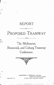 Melbourne Tram Museum
Document - Photocopy, Valentine J. Crowley Consulting Engineer, "Report on Proposed Tramway for The Melbourne, Brunswick and Coburg Tramway Conference", Original 1915
... St, to Royal Park, to Sussex St and Gaffney Road, West Coburg... St, to Royal Park, to Sussex St and Gaffney Road, West Coburg ...Photocopy - Report - 12 pages - titled "Report on Proposed Tramway for The Melbourne, Brunswick and Coburg Tramway Conference", prepared by Valentine J. Crowley Consulting Engineer Oct. 25, 1915. Looks at the construction of a tramway Flinders St along Queen St, to Royal Park, to Sussex St and Gaffney Road, West Coburg for the Melbourne Brunswick and Coburg Tramways Trust. Looks at the route and length of track in detail, route, administration, population, construction, permanent way, overhead lines, feeders, rolling stock, timetable, capital cost, alterations to services, expenditure for year and conclusion. Has a map of the proposed route. Included with the document is a plan of the MBCTT lines, overwritten in ball point pen with street names dated Dec. 1919. Photocopy made from original documents - has been stapled along the side in three places.trams, tramways, mbctt, maps, new tramway, west coburg, queen st, royal park -
 Ballarat Tramway Museum
Slide - 35mm slide/s, Glen Mills, Sept. 1971
... crossed to the west side of the road. Here car No. 38 outbound...: "About 1/2 mile from the terminus the line crossed to the west ...White cardboard mount, 35mm slide, from the Association of Railway Enthusiast's film strip titled "Provincial Tramway Film Strip" of No. 38, crossing Albert St, southbound, with Destination of Sebastopol. Photo taken after tram has passed photographer. Has the Anglican Trinity church in the background. The film strip notes (Reg. Item 2560), provided the following caption details: "About 1/2 mile from the terminus the line crossed to the west side of the road. Here car No. 38 outbound bowls across the asphalt. - Nov. ' 70 (Glen Mills)" See image btm2576p.tif for high level scan of image. Stamped on base of slide "11786" and written in ink on top edge "No. 38 Sebastopol line Ballarat"tramways, trams, are, film strip, albert st, sebastopol, tram 38 -
 Melbourne Tram Museum
Photograph - Set of 9 Colour Print/s, Steven Altham, 27/02/2002 12:00:00 AM
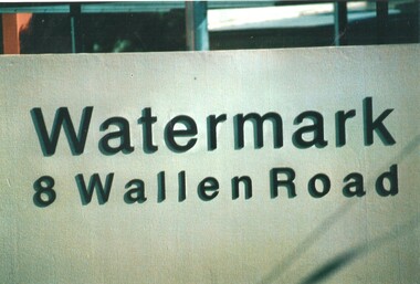
... . .7 - view of the building along Wallen Road from west end.... .7 - view of the building along Wallen Road from west end ...Set of 9 colour prints of the re construction of the Hawthorn Tram Depot to the Watermark Apartments. All taken on 20-9-2002 .1 - The Watermark sign with address .2 - View from looking south with car park entrance. .3 - view from Wallen road looking towards the depot and with overhead up. .4 - Original depot with one of the doors opened. .5 - ditto with the facade of the 5 to 7 roads. .6 - view from Wallen road showing track fan. .7 - view of the building along Wallen Road from west end. .8 - view from the parkland looking north. .9 - ditto.All have details of photograph on rear and photographers name.trams, tramways, watermark apartments, hawthorn depot, construction, tram depot -
 Eltham District Historical Society Inc
Photograph - Aerial Photograph, Landata, Eltham, Feb. 1956
... to east and Eltham Lower Park and Hohnes Road to west. Historic... to east and Eltham Lower Park and Hohnes Road to west. Historic ...Centred on present day Culla Hill and Petty's Orchard, Eltham bounded by Brougham Street and Mount Pleasant Road to north, Monckton Road, Templestowe to south, Reynolds Road to east and Eltham Lower Park and Hohnes Road to west. Historic Aerial Imagery Source: Landata.vic.gov.au Aerial Photo Details: Project No :250 Project : MELBOURNE OUTER SUBURBS PROJECT Run : 18 Frame : 92 Date : 02/1956 Film Type : B/W Camera : EAG9 Flying Height : 10000 Scale : 12000 Film Number : 1176 GDA2020 : 37°43'35"S, 145°09'31"E MGA2020 : 337735, 5822959 (55) Melways : 22 B8 (ed. 42)aerial photo, 1956-02, neil webster collection, eltham, brougham steet, culla hill, eltham lower park, hohnes road, melway 22b8, monckton road, mount pleasant road, petty's orchard, reynolds road, sweeneys lane, templestowe, yarra river