Showing 6989 items matching "historic"
-
 Federation University Historical Collection
Document - Documents, Golden Point - Mount Pleasant Progress Association Establishment
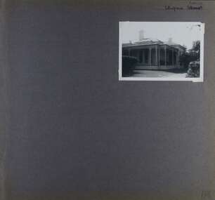
The Golden Point - Mt Pleasant Progress Association was established on Wednesday 6 April 1983. Membership was open to any person or organisation in the area generally bounded by Bridge mall and Skipton Street, Elsworth Street and main Road. annual family or organisation membership was $2.00. Mara Gluyas served as secretary of the Golden Point - Mt Pleasant Progress Association from 1983 to 1994. Ian McKinnon was the President from 1983 to 1992. Kerry Daniels was the President in 1994.A small white cardboard box with purple lid of A4 documents relating to the establishment of the Golden Point - Mt Pleasant Progress Association. The documents include the original constitution and minutes. Topics include: Pearce's Park; removal of elms, names and addresses of members, Sovereign Hill realignment; Sovereign Hill Lookout; membership form; Golden Point Historic Mines Direction Indicator; Ballarat Observatory; Nerrina Tip; Yarrowee Creek; Mine Capping (Sovereign Mine); tree planting (Sovereign Hill Lookout); Magpie Street Park; Hill Street; Yarrowee Flora Park; Barkly Street; South Street Bluestone Gutter; Ballarat Goldfields; Eastern baths site; Grant Street; Flooding; Aboriginal Advancement League; Sunnyside Woollen Mill; Chinese Garden; Golden Point Primary School closure; Ballarat West Goldfields; Sovereign Hill Land Title and Management Revision; Wainwright; Street; Llanberris; Yuille's Station Parkgolden point, mount pleasant, mt pleasant, ian mckinnno, mara gluyas, peter hiscock, frank williams, geoff howard, leigh gillett, sovereign hill, kerry daniels, norm strange; graeme kent; george netherway; keith rash; ian mckinnon, albert graham, bryan crebbin, jim humphreys. wid radbourn, heath martin, janet dore, alex mills park -
 Bendigo Historical Society Inc.
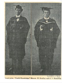
Document - HAMILTON COLLECTION: NEWSPAPER PHOTOGRAPH, Early 1900s
Document. Photograph cut from a newspaper of Mr H. Bradley and Mr A.J.Hamilton. Caption ''Second Prize'', '' Useful Knowledge''. Messrs H Bradley and A J Hamilton. Both dressed in academic robes and are holding an open book: Personal: Alexander John Hamilton Born 7/11/1878 in Nelson, New Zealand. Father Rev. Alexander John Hamilton, Mother Ann Blythe. Married Evelian Lavinia June Ellis in 1907. Their daughter Nancy Blythe Hamilton was born in Bendigo 1n 1911. Alexander John Hamilton died 26/4/1964. Aged 86. Buried Bendigo, MON F3. Evelina Hamilton died 27/10/1965. Aged 86, Buried Bendigo, MON F3. Nancy Blythe Hamilton married Edward Gladstone Townsend in 1933. Historic Rates Index Alexander John Hamilton, Hargreaves St, Grocer, 1902. Partner in grocery Business trading as ''Hamilton and Pulfer''.performing arts, elocution, newspaper photograph. -
 Ballarat Heritage Services
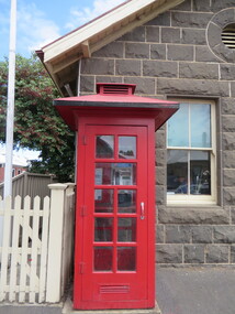
Photograph - Photograph - Colour, Clare Gervasoni, Koroit Post Office, 2015, 21/12/2015
The town borrows its name from the Koroitch Gundidj people who occupied the area prior to European settlement. (https://en.wikipedia.org/wiki/Koroit, accessed 21 December 2016) Koroit was first surveyed as a township in 1847. Around the 1850 the district had the highest population of Irish immigrants in rural Australia. The Koroit Post Office was designed by architect and engineer John Mason of Port Fairy. (Moyne Shire Heritage Study 2006 Stage 2, Volume 2: Environmental History, Prepared for Moyne Shire Council Helen Doyle in association with Context Pty Ltd, 2006.) Rosebrook Bridge, Rosebrook (1853; replaced) Post Office buildings, Bank Street, Port Fairy (c.1857) The author Henry Handel Richardson lived in the Koroit Post Office as a child after her family moved to Koroit in 1878. Remembering Koroit from her youth, the third volume in her The Fortunes of Richard Mahony trilogy is set in the town. When the author was six, her father Walter died in Koroit on 1 August 1879 and was buried at the Koroit cemetery. (https://en.wikipedia.org/wiki/Koroit, accessed 21 December 2016) In 1878 Mary Richardson was appointed postmistress of the Koroit Post Office at a salary of 72 pounds with free quarters, firewood and kerosene. She lived at the back of the Post Office. (From a Green and Pleasant Land by H. McCorkell and P. Yule.) Photographs showing the bluestone Koroit Post Office, phone box and postbox. It is located at 99 Commercial Road, Koroit. "Historic Area Statement of Significance: The significance of Koroit derives from its role as the urban centre of one of the most concentrated Irish Roman Catholic rural districts in Australia, noted for its mixed livestock and cropping argicultural patterns. This is reflected in two separate and distinctive areas in the town - the administrative/commercial area and the church precinct. The administrative and commercial area (focussing on the Boundary-Commercial Road/High Street intersection and the Koroit Hotel) consists of a number of significant public buildings and leads to a street of relatively intact humble shopfronts and kerbline verandahs, visually punctuated by opposing bank facades. The church precinct is dominated by a group of Catholic buildings larger in scale and more complete in range than those in any comparably sized Victorian town." http://vhd.heritagecouncil.vic.gov.au/places/69338#sthash.ELLuSMvg.dpuf, accessed 21 December 2016."koroit, post office, phone box, payphone, bluestone, henry handel richardson, koroit post office -
 Bendigo Historical Society Inc.
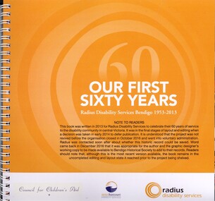
Book - OUR FIRST SIXTY YEARS, 2013
Our First Sixty Years Radius Disability Services Bendigo 1953-2013, this book was written in 2013 for Radius Disability Services to celebrate their 60 years of service to the disability community in central Victoria. It was in the final stages of layout and editing whe a decision was taken in early 2014 to defer publication. It is understood that the project was not revived before the organisation closed in October 2016 and went into voluntary administration. Radius was contacted soon after about whether this historic record could be saved. Word came baack in December 2016 that it was appropriate for the author and the graphic designer's working copy to be made available to Bendigo Historical Society to add to their records. Readers should note that, although this is the most recent version available, the book remains in the uncompleted editing and layout state it reached prior to the project being shelved. Contains 59 pages in a spring bound binder with colour and black & white photographs plus a USB stick.Radius Disability Servicesbooks, technical, disability service -
 Bendigo Historical Society Inc.
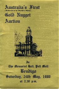
Document - IAN DYETT COLLECTION: AUCTION CATALOGUE - GOLD NUGGET AUCTION
Three gold covered auction catalogues with black printing for Australia's First (Believed to be World's First) Gold Nugget Auction held in the Memorial Hall, Pall Mall, Bendigo on the 24th May, 1980. Catalogues are made of card and are tri-fold. On the front is a black sketch of Bendigo Historic Post Office. The inside which is white are the Conditions of Sale, the centre has the List of Nuggets which includes Lot No., No. of Nuggets and Approx. Lot Wt. in Grains. Under this are the Ingots which includes the Lot No. and Approx. Weight in Grains. Some notes are underneath. On the right fold is A History of Gold Discovery in Victoria and Large Nugget finds in the Area. Also mentioned are the Welcome Stranger Nugget, The Blanche Barkly Nugget and the Robins Nugget. On the inside gold side is A History of 3 D's Gold Mine N.L. and some information about Nuggets. On the back is Curnows name and a Reproduction of Curnows original Letterhead circa 1900.business, auctioneers, j h curnow & son pty ltd, ian dyett collection - auction catalogue - gold nugget auction, 3d's gold mine n.l., bendigo advertiser & clearads, mines department, welcome stranger nugget, red hill company's mine, blanche barkly nugget, precious nugget, ah chang, desmond robins, arthur robins, mining lease 452, mr a sexauer, robins nugget, gold nugget casino las vegas, bolton bros pty ltd, bluey robins, doug cahill, dick sandner, department of minerals and energy, national bank of australasia ltd, commonwealth development bank daryl mcclure, e j dunn, department of mines, curnows (bendigo), j h curnow & son pty ltd, ian dyett, fred dyett -
 Bendigo Historical Society Inc.
Ephemera - Vintage Bendigo calendar, 2015
Vintage Bendigo Calendar, 2015. 12-month calendar. Each month features a historic photo of Bendigo. January, BP Five Lions Service Station, 1960's; February, Phone boxes, 1980; March, Electric trams, circa 1910; April, Terminus Hotel, 1966; May, Plaza Theatre, pre 1975; June, Hargreaves Street, circa 1900's; July, Gillies Pie Corner, 1980; August, Favaloro's Cafe, 1960's; September, Dodges and Chevrolets in front of the Lawcourts, circa 1945-54; October, Easter Procession in Pall Mall, circa 1900; November, Sandhurst Town, 1980's; December, looking up View Street from St. Paul's Church. This calendar is not used - no free-hand notations on any dates/months. On the last pages are public holidays for each of the states/territories; and advertisements for three sponsors - Skills Plus, Next Generation and Lost Bendigo.bendigo, business, parade, calendar -
Bendigo Historical Society Inc.
Ephemera - Vintage Calendar of Bendigo. 2016
2016 Vintage Bendigo calendar. 12-month calendar. One historic image of Bendigo per month. January: Pall Mall, 1870's; February, Bendigo Mall, opened in 1981; March, aerial view of Bendigo Goal and Camp Hill, 1922; April, Easter Monday, Howard Place, 1903; May, 'Aldo's Auto Repairs', St. Andrews Avenue; June, Charing Cross, 1920's; July, Bendigo Municipal pool; August, Ordinance Factory, Shop Number 9, 1940's; September, Gillies corner, 1960's; October, Jim Elvey's View Point Hotel at Charing Cross; 1960's; November, Mitchell Street, 1950's; December, Pall Mall, 1940's. This calendar has not been used, and has no personal notations made on it. At the back are a list of Public Holidays for each state and territory, and a list of sponsors/advertisers, including Haymes, Rotary Club and Lost Bendigo.bendigo, business, calendar -
 Orbost & District Historical Society
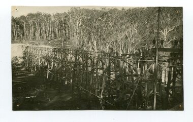
Photograph - Photograph. black + white
The Stony Creek Trestle Bridge was built in 1916 when the existing rail line from Melbourne to Bairnsdale was extended to Orbost. This 97km Bairnsdale to Orbost extension through rugged terrain was reputed to have been the most difficult rail project undertaken in Victoria. In service for over 60 years the bridge was damaged by bushfire in 1980, with the last train crossing in 1987. At 247m long and 20m high, it is the largest standing bridge of its kind in the State, and is listed on the Register of Historic Sites. Built of red ironbark and grey box timber, it is a fine example of the early engineering skills that utilised the resources and materials found on site. (More information Newsletter July 2013)Built during the period 1914-16, of Gippsland Grey Box and Red Ironbark, the Stoney Creek bridge on the East Gippsland Railway is a fine example of early engineering skilll , being constructed without the aid of any of the modern machinery available today. This is a rare photograph and of high significance in showing the bridge under construction.Landscape format black + white photograph (unframed). Four pin holes in each corner, tear to top left quadrant and fold / crease top to bottom in centre of image.construction, 1916, railway bridge, timber industry, trestle construction, stony creek bridge, east gippsland, bairnsdale to orbost line -
 Eltham District Historical Society Inc
Photograph - Aerial Photograph, Landata, Eltham, Vic, Jan. 1951
Centred on Allison Crecent Reserve, Sherbrook Road and Scenic Crescent, Eltham bounded by Allendale Road to north, Dudley Street to south, Zig Zag Road to east and St Helena Road to west. Historic Aerial Imagery Source: Landata.vic.gov.au Aerial Photo Details: Project No :65 Project : MELBOURNE AND METROPOLITAN PROJECT NO. 2 Run : 7 Frame : 10 Date : 01/1951 Film Type : B/W Camera : EAG9 Flying Height : 12200 Scale : 12000 Film Number : 1419 GDA2020 : 37°42'14"S, 145°08'36"E MGA2020 : 336339, 5825416 (55) Melways : 21 H2 (ed. 42)Historical aerial photos and photo maps provide viusal evidence of the chronology of changes to the built landscape of the district and assist in dating other imagesaerial photo, 1951-01, eltham, neil webster collection, allendale road, allison crecent reserve, dudley street, melway 21h2, scenic crescent, sherbrook road, st helena road, zig zag road -
 Eltham District Historical Society Inc
Photograph - Aerial Photograph, Landata, Montmorency, Feb. 1956
Centred on present day Grand Boulevard and Olympic Way, Montmorency bounded by Diamond Street to north, Old Eltham Road and Eltham Lower Park to south, Bible Street to east and Para Road to west. Historic Aerial Imagery Source: Landata.vic.gov.au Aerial Photo Details: Project No :250 Project : MELBOURNE OUTER SUBURBS PROJECT Run : 17 Frame : 115 Date : 02/1956 Film Type : B/W Camera : EAG9 Flying Height : 10000 Scale : 12000 Film Number : 1176 GDA2020 : 37°43'24"S, 145°07'55"E MGA2020 : 335375, 5823236 (55) Melways : 21 F7 (ed. 42)aerial photo, 1956-02, neil webster collection, eltham, main road, montmorency, bible street, diamond street, eltham lower park, grand boulevard, melway 21f7, old eltham road, olympic way, para road -
 Eltham District Historical Society Inc
Photograph - Aerial Photograph, Landata, Eltham, Feb. 1956
Centred on present day Mount Plaeasant Road near Dalton Street, Eltham bounded by Luck Street to north, Eltham Lower Park to south, Reynolds Road to east and Central Park to west Historic Aerial Imagery Source: Landata.vic.gov.au Aerial Photo Details: Project No :250 Project : MELBOURNE OUTER SUBURBS PROJECT Run : 18 Frame : 93 Date : 02/1956 Film Type : B/W Camera : EAG9 Flying Height : 10000 Scale : 12000 Film Number : 1176 GDA2020 : 37°43'02"S, 145°09'38"E MGA2020 : 337871, 5823961 (55) Melways : 22 B6 (ed. 42)aerial photo, 1956-02, neil webster collection, eltham, central park, eltham lower park, luck street, melway 22b6, nyora road, reynolds road, dalton street, mount pleasant road -
 Eltham District Historical Society Inc
Photograph - Aerial Photograph, Landata, Eltham, Vic, Feb. 1956
Centred on present day Parsons Avenue at Leane Drive near the Maroondah Aqueduct, Eltham bounded by Lorimer Road to north, Thompson Crescent and Norman Road to south, Bells Hill Road to east and Parsons Road to west Historic Aerial Imagery Source: Landata.vic.gov.au Aerial Photo Details: Project No :250 Project : MELBOURNE OUTER SUBURBS PROJECT Run : 19 Frame : 5 Date : 02/1956 Film Type : B/W Camera : EAG9 Flying Height : 10000 Scale : 12000 Film Number : 1176 GDA2020 : 37°42'04"S, 145°11'09"E MGA2020 : 340064, 5825786 (55) Melways : 22 H1 (ed. 42)aerial photo, 1956-02, neil webster collection, allendale road, bells hill road, eltham, leane drive, lorimer road, maroondah aqueduct, melway 22h1, norman road, parsons road, research (vic.), thompson crescent -
 Eltham District Historical Society Inc
Photograph - Aerial Photograph, Landata, Eltham, Vic, Apr. 1963
Centred on present day Zig Zag Road and Main Road, Eltham bounded by Maroondah Aqueduct to north, Thompson Crescent and Arthur Street to south, Parsons Road to east and Glen Park Road and Banks Road to west. Historic Aerial Imagery Source: Landata.vic.gov.au Aerial Photo Details: Project No :486 Project : MELBOURNE (1963) PROJECT Run : 5 Frame : 59 Date : 04/1963 Film Type : B/W Camera : RC8 Flying Height : 5100 Scale : 9600 Film Number : 1805 GDA2020 : 37°42'24"S, 145°08'52"E MGA2020 : 336716, 5825114 (55) Melways : 21 J3 (ed. 42)aerial photo, neil webster collection, eltham, 1963-04, arthur street, banks road, glen park road, maroondah aqueduct, melway 21j3, parsons road -
 Eltham District Historical Society Inc
Photograph - Aerial Photograph, Landata, Eltham, Vic, Apr. 1963
Centred on present day Floriston Grove, Eltham bounded by Maroondah Aqueduct to north, Thompson Crescent and Diosma Road to south, Research Shops to east and Glen Park Road and Park West Road to west. Historic Aerial Imagery Source: Landata.vic.gov.au Aerial Photo Details: Project No :486 Project : MELBOURNE (1963) PROJECT Run : 5 Frame : 60 Date : 04/1963 Film Type : B/W Camera : RC8 Flying Height : 5100 Scale : 9600 Film Number : 1805 GDA2020 : 37°42'24"S, 145°09'29"E MGA2020 : 337622, 5825128 (55) Melways : 22 B3 (ed. 42)aerial photo, neil webster collection, eltham, 1963-04, diosma road, floriston grove, maroondah aqueduct, melway 22b3, park west road, research (vic.), research shops -
 Eltham District Historical Society Inc
Photograph - Aerial Photograph, Landata, Lower Plenty, Vic, Apr. 1963
Centred on present day Old Eltham Road near Araluen Centre, Lower Plenty bounded by Cromwell Street to north, Yarra River to south, Main Road at Mount Pleasant Road to east and Panorama Avenue to west. Historic Aerial Imagery Source: Landata.vic.gov.au Aerial Photo Details: Project No :486 Project : MELBOURNE (1963) PROJECT Run : 7 Frame : 231 Date : 04/1963 Film Type : B/W Camera : RC8 Flying Height : 5100 Scale : 9600 Film Number : 1805 GDA2020 : 37°44'03"S, 145°07'56"E MGA2020 : 335420, 5822027 (55) Melways : 21 F10 (ed. 42)aerial photo, neil webster collection, 1963-04, araluen, cromwell street, eltham, lower plenty, main road, melway 21f10, mount pleasant road, old eltham road, panorama avenue, yarra river -
 Eltham District Historical Society Inc
Photograph - Aerial Photograph, Landata, Eltham, Vic, Apr. 1963
Centred on present day Eltham Lower Park bounded by Brougham Street to north, Yarra River and Fitzsimons Lane Bridge to south, Main Road at Kent Hughes Road to east and Bolton Street to west. Historic Aerial Imagery Source: Landata.vic.gov.au Aerial Photo Details: Project No :486 Project : MELBOURNE (1963) PROJECT Run : 7 Frame : 232 Date : 04/1963 Film Type : B/W Camera : RC8 Flying Height : 5100 Scale : 9600 Film Number : 1805 GDA2020 : 37°44'03"S, 145°08'33"E MGA2020 : 336329, 5822040 (55) Melways : 21 H10 (ed. 42)aerial photo, neil webster collection, 1963-04, bolton steet, brougham steet, eltham, eltham lower park, fitzsimons lane bridge, kent hughes road, melway 21h10, yarra river -
 Eltham District Historical Society Inc
Photograph - Aerial Photograph, Landata, Eltham North, Vic, Apr. 1972
Centred on present day Eltham North reserve near Eltham North Primary School, Eltham North bounded by Allendale Road to north, Bellevue Road to south, Zig Zag Road and Beard Street to east and Ryans Road to west. Historic Aerial Imagery Source: Landata.vic.gov.au Aerial Photo Details: Project No :985 Project : MELBOURNE 1972 Run : 26 Frame : 190 Date : 04/1972 Film Type : B/W Camera : RC10 Flying Height : 5700 Scale : 9600 Film Number : 2636 GDA2020 : 37°41'52"S, 145°08'52"E MGA2020 : 336705, 5826102 (55) Melways : 11 J12 (ed. 42)aerial photo, neil webster collection, 1972-04, allendale road, beard street, bellevue road, eltham, eltham north, eltham north reserve, melway 11j12, ryans road, zig zag road, eltham north primary school -
 Eltham District Historical Society Inc
Photograph - Aerial Photograph, Landata, Research, Vic, Apr. 1972
Centred on present day Main Road, Research near Maroondah Aqueduct and Eltham College bounded by Allendale Road to north, Research-Warrandyte Road to south, Swipers Gully Training Restaurant to east and Reynolds Road to west. Historic Aerial Imagery Source: Landata.vic.gov.au Aerial Photo Details: Project No :985 Project : MELBOURNE 1972 Run : 26 Frame : 194 Date : 04/1972 Film Type : B/W Camera : RC10 Flying Height : 5700 Scale : 9600 Film Number : 2636 GDA2020 : 37°42'07"S, 145°11'07"E MGA2020 : 340015, 5825692 (55) Melways : 22 H1 (ed. 42)aerial photo, neil webster collection, 1972-04, allendale road, eltham college, main road, maroondah aqueduct, melway 22h1, research (vic.), research-warrandyte road, reynolds road, swiper's gully -
 Eltham District Historical Society Inc
Photograph - Aerial Photograph, Landata, Eltham, Vic, Apr. 1972
Centred on present day Diamond Creek Trail at the Eltham Leisure Centre bounded by Central Park to north, Main Road at Falkiner Street to south, MacMahon Ball Paddock to east and Grand Boulevard at Buena Vista Drive to west. Historic Aerial Imagery Source: Landata.vic.gov.au Aerial Photo Details: Project No :985 Project : MELBOURNE 1972 Run : 28 Frame : 207 Date : 04/1972 Film Type : B/W Camera : RC10 Flying Height : 5700 Scale : 9600 Film Number : 2635 GDA2020 : 37°43'25"S, 145°08'20"E MGA2020 : 335985, 5823223 (55) Melways : 21 G7 (ed. 42)aerial photo, neil webster collection, 1972-04, eltham, buena vista drive, central park, diamond creek trail, eltham leisure centre, falkiner street, grand boulevard, macmahon ball paddock, main road, melway 21g7 -
 Eltham District Historical Society Inc
Photograph - Aerial Photograph, Landata, Eltham, Main Road; Mt Pleasant Rd to Railway Rd, Dec. 1945
Centred on Main Rd and Henry St, Eltham bounded by Railway Road to north, Mount Pleasant Road at Main Road to south, top of the hill in Arthur Street to east and Karingal Drive at Sherbourne Road to west. Historic Aerial Imagery Source: Landata.vic.gov.au Aerial Photo Details: Project No :65 Project : MELBOURNE AND METROPOLITAN PROJECT NO. 2 Run : 8 Frame : 70 Date : 01/1951 Film Type : B/W Camera : EAG9 Flying Height : 12200 Scale : 12000 Film Number : 1419 GDA2020 : 37°43'06"S, 145°08'45"E MGA2020 : 336589, 5823811 (55) Melways : 21 J6 (ed. 42)aerial photo, eltham, main road, henry street, arthur street, bolton street, eltham-yarra glen road, neil webster collection, 1951-01, dave lyon house, ernie andrew house, karingal road, melway 21j6, mount pleasant road, railway road -
Glen Eira Historical Society
Article - Crotonhurst
A newspaper cutting, labelled as dating to 1937, titled Oldest Home in Caulfield to be Demolished. The article provides that Crotonhurst will be demolished and gives brief details on the property, its history and its auction. It also includes a black and white photograph (73mm x 103mm) of the exterior of Crotonhurst. The file also includes a photocopy of a newspaper article from the Chadstone Progress, dated 20/02/1968, titled Historic Clock for Caulfield – Last Link with Mansion. It gives details of the presentation of a clock from Crotonhurst to the Caulfield Council and provides a description of the clock, a description of the architectural features of Crotonhurst and a brief history of the property. It includes a black and white photograph (53mm x 75mm) of the exterior of Crotonhurst.crotonhurst, pioneers, walworth avenue, caulfield, webb justice, hawthorn road, gleneira road, demolition, architectural features, g p coppard and son, william white and son, mansions, caulfield council, barnes edwin, caulfield town hall, cast iron work -
 Federation University Historical Collection
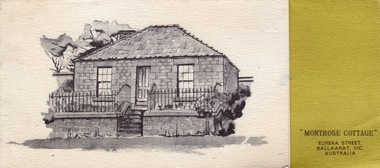
Card - Card - Greetings, ZILLES COLLECTION: Montrose Cottage Christmas Card
Zilles Printers was begun by Lewis Zilles in the early 1930s. It was in McKenzie Street Ballarat. His son Jeffrey also became a printer - letterpress, offset and screen printer. The business became Zilles Printers/Graphics and was in Armstrong Street and later Bell Street Ballarat. Montrose Cottage was build c1856 by John Alexander, builder. He was a Scottish stone mason. It was built with bluestone and hand-made bricks. It is on the Historic Buildings Register, National Trust (Victoria). It is important as a substantial and very early stone cottage. The house is now open to the public. It also provides short term accommodation - self contained apartments. Card produced for Christmas. It has a brief history of the Cottage inside.Thick textured paper, folded. Mustard section with black print. Black and white drawing of cottage."Best Wishes for Christmas and the New Year"zilles printers, ballarat, christmas card, montrose cottage -
 Eltham District Historical Society Inc
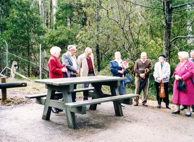
Photograph, Dedication of picnic table at Wilks Creek Bridge, Marysville by Marysville Historical Society, 13 October 1993, 13/10/1993
Wilks Creek Bridge was built in 1870. It was last used for heavy vehicle traffic in 1980 and left to decay until it was demolished in 2008. The last remnants of the timber structure were destroyed in the Black Saturday bushfire of 7 February 2009. [from EDHS Newsletter No. 93, November 1993:] OTHER NEWS A small group of members represented the Society at the opening of the picnic ground at the historic Wilks Creek Bridge at Marysville. The event included the launching of a booklet by our friend Ann Thomas on the history of the bridge which was located on the old Yarra Track coaching route between Eltham and Woods Point. Ann has donated a copy of the booklet to our Society.Two colour photographsactivities, marysville, wilks creek bridge -
 Glen Eira Historical Society
Album - Album page, Ulupna Road, Circa 1972
This album was created in approximately 1972 as part of a project by the Caulfield Historical Society to assist in identifying buildings worthy of preservation. The album is related to a Survey the Caulfield Historical Society developed in collaboration with the National Trust of Australia (Victoria) and Caulfield City Council to identify historic buildings within the City of Caulfield that warranted the protection of a National Trust Classification. Principal photographer thought to be Trevor Hart, member of Caulfield Historical Society. Most photographs were taken between 1966-1972 with a small number of photographs being older and from unknown sources. All photographs are black and white except where stated, with 386 photographs over 198 pages. Page 196 of Photograph Album with one photograph of a Victorian house on Ulupna RoadHandwritten: Ulupna Street (crossed out) Road [ top right] / 196 [bottom right]trevor hart, chimneys, porch, garden, single storey, return verandah, ulupna road, ormond, decorative brackets, cast iron frieze, cast iron columns, full length windows, villa residence, cast iron work, victorian period -
 Westbourne Grammar Heritage Collection
Uniform - Handmade Summer Dress
This was the uniform of junior girls from the 1960s until the new campus for secondary students began at Truganina in 1978. Shortly after the opening of the secondary campus a new dress, green in colour, was adopted for all girls. This summer uniform dress, donated by a past parent, was handmade and worn by a prep student in 1977. It is a rare example of the school dress from this period. Together with a dress pattern and a sample of the same fabric donated by another past parent, these items have historic significance and interpretive capacity. Current students enjoy learning about how different the provision of school uniforms was not so long ago, as Westbourne uniforms can now be ordered online.Small belted dress in blue checked pattern with white collar and sleeve cuffs and three white buttons down the front. -
 Linton and District Historical Society Inc
Photograph, View along Sussex Street to the North, Linton, 2014
The public toilet block in Linton is decorated with hand-made terracotta tiles depicting historic themes. The tiles were produced as part of the Press Mould Tile Project 2001-2002 by Linton Primary School students and community members. Tile design and project coordination was by Pam Farey and Anne Dietrich, and instructors were Pam Farey, Anne Dietrich, Anne Bray and Jeannette Vervaart. The site the toilet block was built on was formerly occupied by 'Criterion House', a building used in the 19th and early 20th centuries as a shop and also a hospital. Criterion House was demolished in 1938/39, to make way for new, enlarged municipal offices, which are still in use in 2019.Colour photograph which shows trees and buildings in Sussex Street, Linton, the Linton public toilet building, and the Golden Plains Shire local offices.golden plains shire offices linton, public toilet building linton, press mould tile project 2001-2002 -
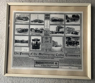 Melbourne Tram Museum
Photograph - Framed, Melbourne & Metropolitan Tramways Board (MMTB), "The passing of the Melbourne Cable Tramways", 1940
"The passing of the Melbourne Cable Tramways", featuring photographs of first cable tram, Fitzroy power house, cable trams in the street, Nicholson St, the No. 1 tram entering the National Museum, some historic notes on the construction of the system, its operations, MMTB takeover, a drawing of the grip and of the badges and buttons used and an image of the cable used. Notes that it was compiled by A. R. Turnbull with co-operation of F. King, K.L.Mackenzie and H. G de Mamiel. Original poster prepared by the MMTB and presented to the State Library or the Museum of Victoria at the time of closure. See Reg Item 6367 for another photograph and 6368 for another poster of the time - Melbourne tramways past and present posterYields information about the Melbourne cable tram system and its history. Frame - wooden outside painted white, glazed with clear glass, off white card backing with brown paper on rear, brass wire hanging wire with small eye hooks the side., containing a photo titled "The passing of the Melbourne Cable Tramways"tramways, cable trams, melbourne, tramcars, closure, museums -
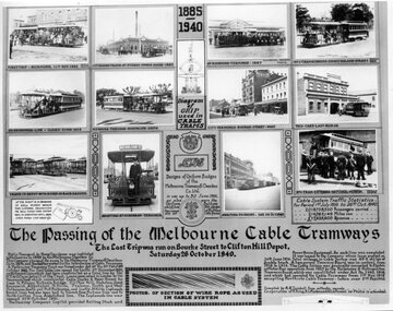 Melbourne Tram Museum
Photograph - Black and White, Melbourne & Metropolitan Tramways Board (MMTB), "The passing of the Melbourne Cable Tramways", 1940
"The passing of the Melbourne Cable Tramways", featuring photographs of first cable tram, Fitzroy power house, cable trams in the street, Nicholson St, the No. 1 tram entering the National Museum, some historic notes on the construction of the system, its operations, MMTB takeover, a drawing of the grip and of the badges and buttons used and an image of the cable used. Notes that it was compiled by A. R. Turnbull with co-operation of F. King, K.L.Mackenzie and H. G de Mamiel. Original poster prepared by the MMTB and presented to the State Library or the Museum of Victoria at the time of closure. See Reg Item 2854 for a framed photograph and 6368 for another poster of the time - Melbourne tramways past and present poster Yields information about the Melbourne cable tram system and its history. Photograph - of a MMTB Poster titled - "The passing of the Melbourne Cable Tramways"tramways, trams, cable trams, closure, museums, melbourne -
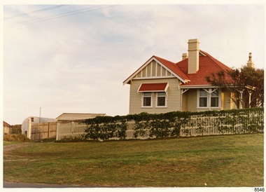 Flagstaff Hill Maritime Museum and Village
Photograph - Historical, Flagstaff Hill, Harbourmaster’s Quarters, 1970s
The photograph shows a cottage, Harbourmaster’s quarters that still stands on the east of the Lady Bay Lighthouse and Historic Precinct at Flagstaff Hill in Warrnambool. The name was changed to the Lighthouse Lodge, and today guests can stay at the property. This photograph, a print, is one of a set of five that show the site of Flagstaff Hill. It is presumed to have been taken by John Lindsay, Founding Director of Flagstaff Hill Maritime Museum and Village. One of the photographs in the set has the pencil inscription "Photo J Lindsay". It was taken in the early 1970s during the initial stages of the development of Flagstaff Hill as a Museum and Maritime Village. The photographs belonged to the donor's grandparents, who lived in the Warrnambool district of Allansford/Naringal. The photograph is a record of the site and surrounds of Flagstaff Hill Maritime Museum and Village before its development and opening in 1975. It shows the cottage on the east of the Lighthouse Complex,. The building is now known as Lighthouse Lodge. The photograph is significant for recording the location and condition of the residence on the Hill.Coloured photograph, glassy print, one of a set of five. Photograph shows the cream timber cottage, Harbourmaster’s quarters to the east of the lighthouse complex at Flagstaff Hill, Warrnambool. On the left of the red roofed residence are iron buildings used, at the time, by the Lands Department. The photograph's paper has the printer's watermark on the back. The early 1970s photograph is presumed to have been by John Lindsay, Warrnambool.Label on the back: "WOODEN RESIDENCE TO THE EAST OF THE PROPERTY / The gun emplacements are immediately behind, and the iron huts to the left rear of the residence are used by the Lands Department who plan to vacate, for other premises."flagstaff hill, flagstaff hill maritime museum and village, warrnambool, maritime museum, maritime village, great ocean road, shipwreck coast, 1970s, photograph, flagstaff hill site, john lindsay, cannon emplacement, residence, wooden residence, timber residence, iron huts, lands department -
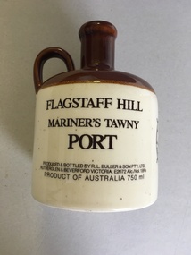 Warrnambool and District Historical Society Inc.
Flagon, R. L.Buller and Son Pty Ltd, Flagstaff Hill Maritime Village, 1970s
This flagon which once contained 750 ml. of tawny port was sold at Flagstaff Hill Maritime Village in Warrnambool in the 1970s and perhaps the 1980s as a souvenir of the village and Warrnambool. Flagstaff Hill Maritime Village was opened in 1975 and is a re-created 19th century village and port built in the area of a Warrnambool historic precinct containing several original features from the 19th century. These include two operating lighthouses, lighthouse keepers’ quarters, chart room and a fortifications area with two cannons. As the village is a re-created port and includes a hotel called the Steam Packet Inn, the sale of a souvenir flagon of tawny port was most appropriate. Flagstaff Hill Maritime Village and Museum still operate today. This flagon is retained as an example of the souvenirs sold in Warrnambool some years ago to tourists visiting Warrnambool and Flagstaff Hill Maritime Village. This is a ceramic flagon with a cream body and a brown top and handle. The printing on the flagon is black and the flagon also has black printing of the logo of Flagstaff Hill Maritime Village. The flagon has no stopper.‘Flagstaff Hill Mariner’s Tawny Port’flagstaff hill maritime museum, warrnambool