Showing 2469 items matching " black bridge"
-
 Kiewa Valley Historical Society
Book - Kiewa River, Stocking and Crossing the Kiewa River by Jan Hunter (nee Chick), 2020
The Chick brothers, Alf, Les and Allan, plus friends, began trout fishing and camping in the Kiewa Valley before the early 1930s. Les continued his connection with the Kiewa River until his death in 1972. Fingerlings were placed in the Kiewa River from the early 1880s. Keegan's Bridge is a crossing near Upper Gundowring and about 4 km south east of Dederang. References to the crossing were made in the early 1900s and a petition presented to Council in 1904 calling for a bridge.The bridge was built and opened in 1907. The photos are of the release of fingerling trout in the Kiewa River, thought to be at Keegan's Bridge. The fingerlings were transported in drums on the back of trucks. The photos are c1940s.The Kiewa Valley has been a popular spot for fishermen, tourists and campers from the 1880s. One of the many attractions has been the excellent fishing along the Kiewa River due to the regular release of fish especially brown trout. This continues to the present day (2020) when a few fish were marked with $$ signs for the lucky fisherman who caught them. This attracts visitors, their families and boosts the economy and dates back to visits at the Tawonga Pub prior to the Kiewa Hydro Electric Scheme.19 page book with black plastic spine and clear plastic cover over the beige paper cover with title , author and black & white photo. Note: In KVHS photo collection there are 4 good quality reproduction photos on photographic paper. These have been produced professionally. These photos of Jan Hunter's are featured on the second page of her book. These also have a letter attached. The book is a pre-research paper & is No 33 of the Albury and District Historical Society Papers. The sub-title is "Trout releases and Keegan's Bridge / from the newpapers, 1882-1935"None on the book but a letter is attached from Jan Hunter, the author as a follow up to the photos she donated. On the photos - On the back: Fujifilm / Fujicolor Crystal Archive / Paper / Production - run codekiewa river; trout; fish; keegan's crossing; keegan's bridge; fingerlings; chick family; camping; tourism -
 Kiewa Valley Historical Society
9 small black and white Photographs, c1950
These photos were taken in 1950 by Bill Peel who was appointed as a secondary teacher at the newly built Mt. Beauty School in January 1950. He was the entire secondary staff for an enrolment of 4 students in Form 3 (year 9), 9 in Form 2 and 25 in Form 1. There were also 4 primary teachers as the school combined both primary and secondary education. He was provided with accommodation at the staff hostel (Mt. Beauty Chalet). A autobiography is also enclosed describing his 12 months as a teacher in Mt. Beauty.These photographs give a clear picture of the stage of construction of housing in both Bogong Village and Mt. Beauty in 1950. Large workmen's camps are clearly visible at both sites. Construction at Rocky Valley Dam site has just begun. They are of historical significance. The autobiography gives an excellent insight into conditions teachers faced in small country schools;Nine small black and white photographs3 photos stamped with "1 856", 4 photos stamped with "210, 2 photos are identified with hand written inscriptions, in ink, on the back - "Railway Bridge Bright '50" and second photo "Lake Catani '50" also 'Kodak' circular stamp on back of both.mt. beauty, bogong, acccommodation, education, rocky valley -
 Kiewa Valley Historical Society
Book - Student's exercise book, Exercise Book used for dictation
The Education of English in 1913 / 1914. Hand writing in 1913 / 1914. Historical: Education through the ages. Provenance: Olivia Fisher lived in the Kiewa River at Mongans Bridge. She was a prominent member of the KVHS and donated many significant items. Black blank cardboard cover. Used as an exercise book for composition, dictation in 1913 by Miss Fisher.Olivia Fisher Mongans Bridge on inside of cover. Pages neatly written in ink but with a water stain on early pages. Very neat writing with title eg. Composition, Dictation and dated June 1913 to May 1914education. english. olivia fisher. mongans bridge. composition. dictation. handwriting. -
 Kiewa Valley Historical Society
Book - Student's Exercise Book, Exercise book used at school, Used in 1912
Educational: handwriting of the time. Also Maths, Dictation. Everil Fisher's family lived at Mongans Bridge in the Kiewa ValleyHistorical: comparison of book work, hand writing, dictation and maths in 1912 to current times. Provenance: Everil Fisher's family lived at Mongans Bridge. Her family donated many significant items to KVHS showing an interest in history.Plain black hard covered exercise book with handwriting, mathematical, and dictation exercises. Pages are blue lined. Cotton thread spine binding. Inside front cover: Everil Fisher / Mongans Bridge / Via Dederang Exercises dated Jan. 24th 1912 to 29th Oct. 1912 Corrections and comments in red. Written work in greyish ink.education. handwriting. mathematics. dictation. everil fisher. mongans bridge -
 Kiewa Valley Historical Society
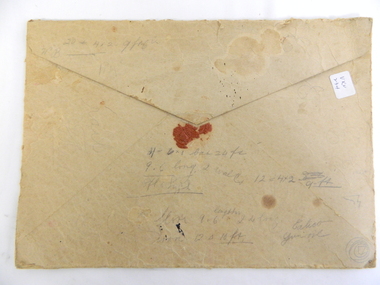
Envelope - OHMS Examination Papers Only, 1916
In 1916 students were examined by the Victorian Education Department and not by the local school. This included small rural schools and involved mail delivery.Mongan's Bridge was a small, remote, rural school in the Kiewa Valley.Large brown thick cardboard envelope with traditional triangle flap for opening and broken red seal. Yellow/brown with black writing and x2 pale green 3d stamps on the top right-hand corner (green kangaroo inside white map of Australia). In black writing: OHMS Examination Papers Only / Not to be Opened till 9 am on 21-11-1916. Addressed to: The Head Teacher / School No" 3403 / Mongan's Bridge / Via Dederang" (" to " hand written in grey lead on ruled line) At bottom left of envelope: 0 x2 and underneath M x2 / Education Department / Melbourne. On back: Seemingly unrelated and hard to read writing and figures.On Back: Seemingly unrelated and hard to read writing and figures. education, mongan's bridge school, teacher, examinations, australian stamps, assessment in the primary school -
 Kiewa Valley Historical Society
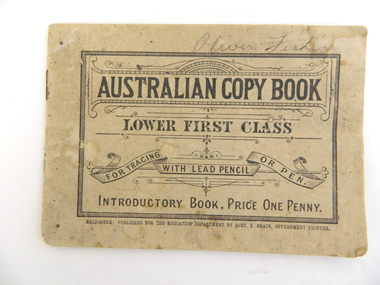
Book - Student Exercise Book for Writing, Australian Copy Book / Lower First Class, 2.10.1906 to 2.7.1907
In 1906 and 1907, students were taught to write with the letters joined. To achieve this booklets were designed to enable the student to copy the example and to repeat this, often to gain perfection. A student could be practising his/her writing while the teacher attended to other students and/or classes.Oliver Fisher lived at Mongan's Bridge a small, remote, rural area in the Kiewa Valley.Soft covered small booklet - grubby blue on back and very faded 'blue' on front with black writing. Held together with 2 staples. "For Tracing with lead pencil or pen. / Introductory Book, Price One penny" Writing surrounded by fancy graphics. Border is thick but not solid black line.Inside book letters have been copied but joined up to practice writing eg. m m m and then mu mu mu Each page is different. On some pages the date has been writteneducation, writing, mongan's bridge, oliver fisher, school -
 Kiewa Valley Historical Society
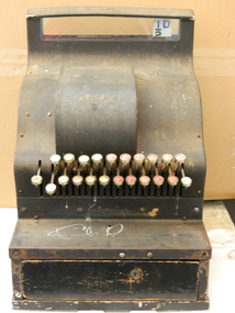
Cash Register, 1905-1906
Cash registers were used by businesses to store the money received for the transactions of goods and for recording the amount of money taken over a period of time e.g.. a day. This cash register is pre 1966, pre decimal currency and includes the halfpenny.Dudley Pigram who managed the Mongan's Bridge Caravan Park used this register. He brought it down to the Mt Bogong Clay Target Club in the 1970's although it is pre decimal currency. Dudley wass a founding member of the Clay Target Club.This brass cash register has a serial number indicating that it was made between 1905 and 1906. It is very heavy. A black metal cash register with glass across the top where the amount of the sale is displayed. There are 2 rows of keys - the top row left to right - 8/-, 6/-, 4/- 2/- with white background, 11d, 9d, 7d, 5d, 3d, 1d with red background. Bottom row left to right - 9/-, 7/- 5/- 3/- 1/- with white background, 10d, 8d, 6d, 4d, 2d, with red background plus a digital half d with a white background. Between the rows on the left is a 'No Sale' key. At the front of the register is a locked tray.Serial number S 33148. B.214KAA on a gold plaque below the glass display in the middle. On its right is a key hole. 'National' - above the keys. cash register. mongan's bridge caravan park. mt bogong clay target club. dudley pigram. business. -
 Warrnambool and District Historical Society Inc.
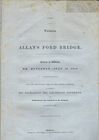
Document, Allan’s Ford Bridge 1852, 1852
This is an original Victorian Government document containing the printed version of 37 reports and letters regarding the building of the first Allansford bridge completed early in 1852. The correspondence dates from October 1850 to February 1852 and includes letters and reports from Melbourne Government employees such as Robert Hoddle, Chief Surveyor, David Lennox, Superintendent of Bridges and Lieutenant – Governor Charles La Trobe. The correspondence from local settlers included the names of William and John Allan, John Davidson and James Coulstock. The correspondence shows that some settlers in the Warrnambool/Port Fairy district wanted a portion of the Government allocated funds spent on the local roads and bridges in other locations. The 1852 Allansford bridge cost £480 and was replaced in 1870. This document has strong historical significance as it relates to one of the earliest State government works in the district and records the public imput into the decision.. It contains opinions and correspondence between a number of early settlers in the district at the time.Grey/blue paper document with black text. 21 pages plus 4 page index at back.allan's ford 1852, allansford bridge, allansford, history of allansford, warrnambool -
 Warrnambool and District Historical Society Inc.
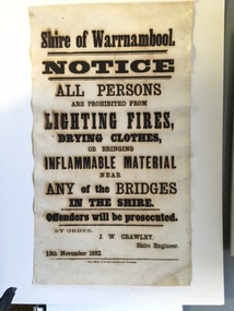
Document, Shire of Warrnambool Fire - Washing-Bridge 1882, 1882
This notice relates to the prohibition of lighting fires,drying clothes or bringing inflamable material near any of the bridges in the shire. Offenders will be prosecuted. With a date of 1882 and the fact that bridges were mostly made of wood, it would have been of concern that the destruction of bridges was not only of great inconvenience but also of considerable expense. But the reality of bridges providing shelter and warmth in the colder months and the ensuring fires and burnt bridges has more than likely precipitated this notice. J W Crawley was shire engineer from 1876 until 1895 and for 10 of those years he trained his son J W Crawley who succeeded his father and served in the position for 40 years.He in turn was succeeded by his son Rolf Crawley in 1935. In 1963 the bridge over the Hopkins Falls at Wangoom was named the Crawley bridge in honour of service to the Shire of Warrnambool by members of the Crawley family. The Shire of Warrnambool was proclaimed in 1863 and covered an area of over 600 square miles. Much of it was incorporated into the Moyne Shire in the 1990's with some being included into the boundaries of City of Warrnambool. This banner is an interesting piece of history. It shows the issues confronting early settlers such as shelter and the chores of daily life but also the importance placed on infrastructure which was slowly taking place around the district. It was in the era of drainage and roadworks and hence bridges were an important part of that infrastructure. The name J W Crawley is one of importance in the Warrnambool district for his service over many years. Rectangular piece of cloth printed in black ink. The back is plain.Shire of Warrnambool By order of J W Crawley Shire Engineer, 13th November 1882. Thos Smith gas Printing Works Koroit Street Warrnambool.warrnambool, shire of warrnambool, bridges of warrnambool shire, j w crawley, warrnambool shire engineer, crawleys of warrnambool -
 Warrnambool and District Historical Society Inc.
Administrative record - Note book
This note book contains details of the men who worked, mainly as casual labourers, at the farm Boughton at Cassady's Bridge near Warrnambool. The dates are from 1859 to 1872. The names of the workers and their wages and transactions have been recorded by either William Cassady or a foreman. The entries are notable for the original creative spelling and the lack of information on the names of the workers, often referred to by their first name or a nick name. William Cassady (1824-1885) purchased Boughton in 1846 and he and his wife, Elizabeth had fourteen children.This note book is of considerable significance because it is an early record of the property Boughton and its workersThis is a note book with a metal fastener, and a cloth cover with a green mottled pattern inside. The pages have printed red lines and black hand writing. The cover is stained and partly detached from the binding.william cassady, boughton, cassady's bridge -
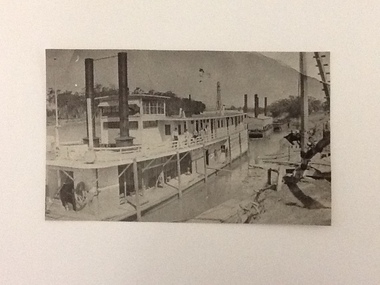
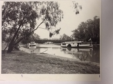
 Port of Echuca
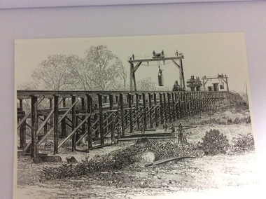
A black and white photograph of a drawing, Black and white photograph of a drawing depicting the construction of the iron Murray Bridge, at Echuca, showing Surveyor, bridge workers, hoists, a crane, and much activity, 1981
Original negative and photograph held by The Age, before by Orm Cook, Echuca. Photo is of a drawing of Bridge work taking place in 1877, across Murray River at Echuca. Orm Cook gave The Age the photograph in 1981 as the round arches on the bridge were about to be removed.A bridge crossing of the Murray River was needed by 1877. It linked Echuca and Moama in a more tangible way. The bridge was funded privately and public use of it was discussed for the next several years.A black and white photograph of a drawing, depicting the construction of the iron Murray Bridge at Echuca, showing the Surveyor, the bridge workers, hoists , a crane, and much activity.Written in pen on the back, "Murray Bridge at Echuca under construction. Original to 'Age' came from Orm Cook. Also the numbers 6530 written in pen. Also on the back is a rectangular stamp with these words inside the rectangle. "COPYRIGHT. This photograph may not be reproduced without permission in writing from the Editor of "The Age" 250 Spencer Street, Melbourne, and 39/41 York St, Sydney.murray river, bridge work, bridge construction, bridge workers., the age newspaper., orm cook. -
 Port of Echuca
Black & white photograph
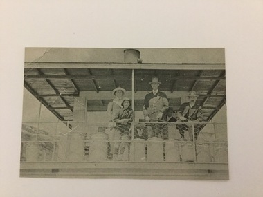
... and at the Murray Bridge Echuca. Black & white photograph ...Black & white photograph of 2 men, 1 girl and 1 boy on upper deck of P. S. Kelvin. In the background is a 3rd man, Hugh Price, at the wheel. Documented as being on mail run and at the Murray BridgeDemonstrates passenger transport and travel along the river as well as the delivery of mail services between rural communities.Black & white photograph of 2 men, 1 girl and 1 boy on upper deck of P. S. Kelvin. In background is a 3rd man, (Hugh Price) at wheel. Documented as being on mail run and at the Murray Bridge Echuca.In pencil on back : Kelvinp.s. kelvin, murray bridge, mail run, paddlesteamers, murray river, hugh price -
 Port of Echuca
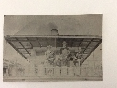
Black and white photograph
... run and at the Murray Bridge (at Echuca) Black and white ...A copy of a black and white photograph of paddle steamer travel along the Murray river. It shows passengers (2 men, 1 girl, 1 boy) on the upper deck of the P. S. Kelvin, around the late 1890-1900. In the background is a third man, Hugh Price, at the wheel of the paddlesteamer. On the back of the photograph is documented as being on the mail run and at the Murray Bridge.Demonstrates passenger transport and travel along the river as well as the delivery of mail services between rural communities around the Murray Bridge, Blanchetown region in South Australia around 1890-1900.Copy of a Black and white photograph of 2 men, 1 girl and 1 boy on upper deck of P. S. Kelvin. In background is a 3rd man, Hugh Price, at the wheel. Documented as being on mail run and at the Murray Bridge (at Echuca)Kelvin on mail run, Murray Bridge. Hugh Price at wheel in rear.murray bridge south australia, p.s. kelvin, mail run, hugh price, cargo, price family collection -
 Port of Echuca
Photograph - Black and white photograph, approx. 1980
P.S. Captain Sturt, with a pile driver in the background. Possibly at Blanchetown. There are 5 men on the upper port deck. The paddle-steamer has 2 funnels and the pile driver has 4 funnels. The wheelhouse is above the upper deck.Demonstrates the use of floating pile drivers to assist in the construction of bridge or wharf building along the river Murray river in approximately the 1920's. The Captain Sturt is in close up so the structure of the paddlesteamer is clear. Rectangular, black and white copy of original photograph of P.S. Captain Sturt, with a pile driver in the background. Possibly at Blanchetown. There are 5 men on the upper port deck. The paddle-steamer has 2 funnels and the pile driver has 4 funnels. The wheelhouse is above the upper deck.In pencil on back: CaptainSturt, Blancheltown or similar. Pile driver in background. On photograph "Captain Sturt" is visible on front and side of the paddlesteamer.blanchetown, p.s.captain sturt, pile driving, murray river, south australia, 1920's -
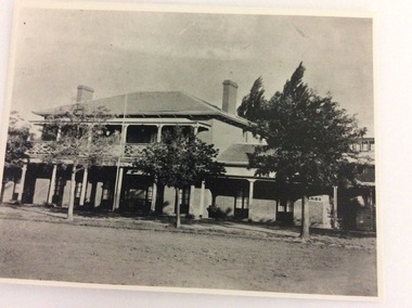 Port of Echuca
A black and white photograph, The Bridge Hotel, in 1896, showing Silky Oak trees, 1970's
The Bridge Hotel was built by Henry Hopwood to house visitors to the town crossing the Murray River on his punt crossing, which was situated just below the Bridge Hotel on the Murray River. The accommodation was spacious and grand! In the right back corner of the photograph, the 'lantern' roof of the St Georges Hall can be seen. The street is level with the front entrance to the Hotel, which is very different to what it is today.The photograph shows hotel activities and accommodation in the late 19th Century.A black and white photograph of the Bridge Hotel taken from the Hopwood Gardens. The photograph shows four silky oak trees growing along the front of the building. There is an empty flag pole outside the front of the building. The right wing advertises billiards, whilst the left wing apparently was a bar.Written on the building can be seen the words; HOTEL and BILLIARDS. Written in pen on the back of the photograph are the words "Bridge Hotel. Probably 1896, showing Silky Oak trees.bridge hotel, henry hopwood, silky oak trees, lantern roof, st georges hotel -
 Port of Echuca
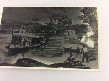
Black and white photograph of an engraving, Approximately 1970
This is a photograph of an engraving showing the first train arriving at the Echuca Wharf on 25/09/1865. The photograph appeared in the Illustrated Australian News on 25/09/1865. It also appeared in Susan Preiestly's book, 'Echuca; A centenary history' in 1965 on page 46.. The picture is of interest because it shows the size of the wharf in 1865. It also shows all the crowds to welcome the first train. It also shows the buildings along Murray Esplanade. In the far left the Steam Packet Hotel, Shackell's Bond Store and the St George's Hall, next the The Bridge Hotel. Five large steam ships are visible, all carrying crowds of people. In the foreground is the S.S Melbourne. Two rowing boats are in the left foreground.This engraving is significant because it shows the welcoming of the first train onto the wharf. The photograph shows the size of the wharf in 1865, as well as the street scape and the vessels on the water at the wharf. There is also some activity at Evan's sawmill. There are crowds on the wharf, and lining Murray Esplanade. It also shows that most of the crowd are males, which helped describe the role that women played in public life in the 1880's. A black and white photograph of an engraving of a busy Echuca wharf scene in 1865. The first train is arriving at the wharf. There are crowds of people, and in the foreground is the S.S. Melbourne. On the front of the photograph in the bottom right hand corner are the letters R.G. (Is this the Artist's initials?) On the back of the photo, written in pencil are the words "Day first train came through to the wharf. Of interest because of buildings far left. Steam Packet 1865. From Ilustrated Australian News. 25th September 1865."echuca wharf, susan preistley, railways, state library of south australia., illustrated australian news., s.s.melbourne, steam packet hotel, shackell's bond store, st george's hall, bridge hotel -
 Port of Echuca
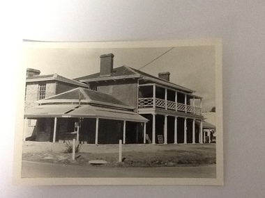
Black and white photograph, 20.04.1979
... in pen :" 1" Black and white photograph of the Bridge Hotel ...Relates to a series of 5 photos:P000094-P000098 of the front of the Bridge Hotel on the corner of Murray esplanade and Hopwood gardens. These photos taken in 1976, were before the Port Restoration Scheme renovated the hotel.The Bridge Hotel, Echuca is of historical and social significance in that it was originally built by Henry Hopwood, the founder of Echuca. Hopwood built the hotel to provide accommodation to people using his punts across the Campaspe and Murray rivers. The hotel was situated between the 2 punts. The hotel provided for a variety of levels of accommodation from grand rooms to very basic rooms. At the time of the photos the hotel was 120 years old and became an important part of the Port of Echuca tourism. Black and white photograph of the Bridge Hotel , taken from the corner of Murray esplanade and Hopwood gardens. A power pole pokes through the verandah roof of the eastern (left) wing. The eastern wing of the Bridge is clearly visible.On sign on the front verandah "unauthorised entry not permitted". On back of photo in pen :" 1"bridge hotel, echcua, port restoration scheme, bridge hotel restoration, echuca -
 Port of Echuca
Black and white photograph, Approx. 1980
Information of construction of Pride of the Murray. Construction: Composite Tonnage: 71 gross 36 net Dimensions: L 82.4 ft B 15.5 ft D 4.4 Date of Registration: Melbourne 1870 no.88, 918 Built: Echuca, Vic. 1865 Owners: Permewan, Wights & co.This photo has Social and historical significance,depicting some of the boats and the wharf in the 1980's. It gives a very clear visual of the Port of Echuca wharf and the Echuca banks of the Murray with some of the beach visible. Black and white satin photograph of the starboard side of the P. S. Canberra sailing upstream on Murray river between the Port of Echuca wharf and the Echuca bridge. The Pride of the Murray (front on) can be seen further behind , on the left, with the Pevensey, which appears to be moored in front of the wharf in the background. On front of photo paddlesteamers are marked Canberra & Pride of the Murray. On back of the photo is marked in pencil: please return to Mrs H.Coulson, Port of Echuca, Box 35, Echuca.echuca wharf, p.s. canberra -
 Port of Echuca
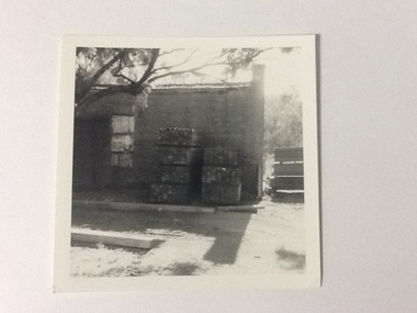
Black and white photograph, Approx. 1975
The old brick Murray River Sawmill office was demolished around 1975. This appears to be part of one of the office buildings associated with the sawmill, taken in shadow, with the building well back on the block, on the bridge side. There is a dirt driveway in front of the building and stacks of timber next to the chimney side of the building. Trees are visible behind these stacks of timber. Two stacks of timber (1x 4 blocks high, 1 X 3 blocks high) are in front of the building between the window and the chimney This relates to photographs P000106, P000105 Sawmills in the Echuca area were historically and socially significant being a large employer in the area. The Murray River sawmill was one of the biggest and longest operating sawmills in the area. Black and white photograph of an old Murray River Sawmill building with the chimney to the right and a door and window on the left. Two stacks of timber planks are against the wall between the window and the chimney. A dirt driveway is in front of the building with timber planks edging the driveway.On the reverse in pencil "Old M. R. S. Building well back on the block on the bridge side. Near old offices, also demolished about 1975??" Kodak, , in blue ink "0932"murray river sawmills, echuca, echuca, victoria, pullicino, j (unconfirmed) -
 Port of Echuca
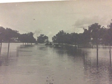
A black and white postcard, 1906. or. 1916
The postcard is significant because it shows the extent of the flood in the early 20th Century. The bridge crosses the Southern Cross channel which had been built as part of the Murray Darling irrigation system. There is a vehicle on the bridge either being towed by bullocks or horses. Floodwaters cover the whole view.The postcard is significant because it shows the extent of the flood in the early 20th Century. The bridge crosses the Southern Cross channel which had been built as part of the Murray Darling irrigation system. It is also near the water filtration plant which filters the town's water supply. There is a vehicle on the bridge either being towed by bullocks or horses. Floodwaters cover the whole view.A black and white postcard showing Goulburn Road, Echuca East, in either the 1906, or 1916 floods.Printed on the back are the words; W. Grimwood Echuca. POST CARD. Correspondence Address Only Kodak Australia. Hand written on the back are the words 1906 or 1916? Southern Cross bridge near filtration plant. Goulburn Road, Echuca East.floods, goulburn road, echuca east, pullicino, j, postcard, southern cross channel, water filtration plant -
 Port of Echuca
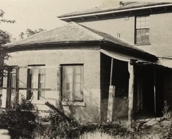
Photograph - Black and white photograph, Late 1970s
Relates to a series of 5 photos:P000094-P000098 of the front of the Bridge Hotel on the corner of Murray esplanade and Hopwood gardens. These photos, taken about 1976, were before the Port Restoration Scheme renovated the hotel. The Bridge Hotel was built by Henry Hopwood in 1858. This and the Bond Store were Echuca's first 2 brick buildings. Named from Hopwood's nearby pontoon bridge. The building was bought be The Council in 1970. Restored and reopened in 1975.The Bridge Hotel is an important part of Echuca's settlement and development. It was originally built by Henry Hopwood, the European founder of Echuca, in 1859. Hopwood built the hotel to provide accommodation to people using his punts across the Campaspe and Murray rivers that area central to the landscape of the Port. The hotel was situated on the land between both rivers and punts and provided for a variety of levels of accommodation from grand rooms to very basic rooms. At the time of the photos the hotel was 120 years old and became an important part of the Port of Echuca tourism. Black and white photograph of the Bridge Hotel , showing western wing before restoration.Stamped on the reverse "Gazemore Studio, D. G. Gay, 18 Frances Street Echuca 3625.bridge hotel, echcua, port restoration scheme, bridge hotel restoration, echuca -
 Port of Echuca
Black and white photograph, Mid 20th Century
... the iron bridge at Echuca. Black and white photograph ...The P.S Canberra was built in 1912 at Goolwa South Australia by David Milne. It was built as a fishing vessel. It was originally a steam engine, reverted to diesel, but was returned to steam in 1995. It is currently owned by the Murray Steam Ship and Tourist Co. and has operated as a tourist vessel at Echuca Since 1967. (Ref Parsons, R "Ships of the Inland Rivers " p. 58)The P.S Canberra is significant as it has operated as a tourist vessel since 1967, and continues to do so. A black and white photograph of the P.S.Canberra coming downstream from the iron bridge at Echuca.On boat the words Canberra.p.s canberra, murray steam ship & tourist company -
 Port of Echuca
Black and white photograph
P.S Decoy was built in Scotland and reassembled in 1878 in Melbourne. It steamed to Goolwa, arriving in July 1878. It was used on the Darling River, and as a South Australian tug. In 1905 it sailed to Fremantle W.A for use as an excursion vessel. It was towed back to work on the inland river trade on the Darling -Murray system in 1909. It is now a house boat at Mannum. It's owner is Dick Bromhead.( Ref; Parsons, Ron. "Ships of the inland Rivers. P. 65.)The P.S Decoy is significant because it worked as a passenger vessel as well as a transport vessel. It was built in Scotland and reassembled in Melbourne. It was built to use coal, but when it started work on the inland rivers system it was converted to wood fuel.Two black and white photographs ( P000385.1 is missing) of the P.S Decoy passing under a bridge. There are high banks behind the boat and there are nine people on board.On the boat is the word 'Decoy' written on the bow and under the wheelhouse.p.s decoy, darling river, murray river, goolwa, mannum, passenger vessel, bromhead, dick -
 Port of Echuca
Black and white photograph, 1971
This is a photograph showing the P.S. Alexander Arbuthnot about to be removed from the water to be transported to Shepparton for restoration. The Alexander Arbuthnot was pulled off the bottom of the river at Yielma in July 1972 and taken to Shepparton via Barmah in January 1973.This photograph is significant as it shows the P.S Alexander Arbuthnot about to come out of the river, to be fully restored.A black and white photograph 13 cms X 9 cms of the P.S Alexander Arbuthnot under the Barmah Bridge, prior to being taken out of the river and taken to Shepparton.Written on the back of the photo are the following words. "Alexander Arbuthnot being moved into position under the Barmah Bridge prior to removal from the water and transported to Shepparton for restoration 1971 - 1973. The paddle screamer was previously sunk near the Victorian bank. At Newmans property at Yielma." paddle steamers, ralton, greg, shepparton, p.s alexander arbuthnot, international village shepparton, yielma -
 Eltham District Historical Society Inc
Photograph, Fay Bridge, Fay Bridge with the Lasting Memories Mosaic Seat, St. Andrews Hall, 1 Proctor Street, St. Andrews, n.d
The Lasting Memories Mosaic Group Seat is part of Nillumbik Shire Council's Public Art. Following the Black Saturday Bushfire of February 7, 2009, which ravaged St Andrews and surrounding district, a group of bushfire affected women formed the Lasting Memories Mosaic group and created this concrete seat covered in mosaic as part of their healing process. It was completed in 2012. For more information see Nillumbik Shire Council's link Public Art: Lasting Memories Mosaic GROUP, Lasting Memories Mosaic Seat - https://victoriancollections.net.au/items/58536395d0ce201b746561c6fay bridge collection, fay bridge, mosaics, st andrews, lasting memories mosaic group seat, st andrews hall -
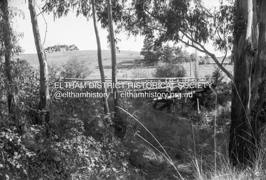
 Eltham District Historical Society Inc
Negative - Photograph, Russell Yeoman, Bridge over Arthurs Creek, Chapel Lane, Nutfield, c.1970
Roll of 35mm black and white negative film, 4 of 7 strips and corresponding B&W printIlford HP4chapel lane, arthurs creek, nutfield, bridge -
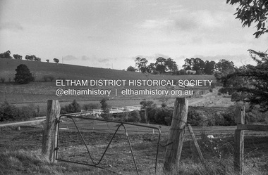 Eltham District Historical Society Inc
Negative - Photograph, Russell Yeoman, Linton's bridge over Arthurs Creek, Nutfield, c.1970
Roll of 35mm black and white negative film, 4 of 7 strips and corresponding B&W printIlford HP4arthurs creek, arthurs creek road, bridge, linton's bridge -
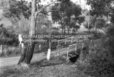
 Eltham District Historical Society Inc
Negative - Photograph, Russell Yeoman, Cottles Bridge over Diamond Creek, Cottles Bridge-Strathewan Road, Cottles Bridge, c.1970
Roll of 35mm black and white negative film, 4 of 7 strips and corresponding B&W printIlford HP4bridge, cottles bridge, cottles bridge-strathewen road, diamond creek (creek) -
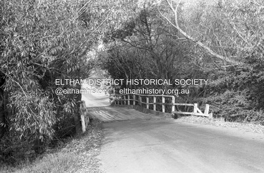
 Eltham District Historical Society Inc
Negative - Photograph, Russell Yeoman, Cottles Bridge, c.1970
Roll of 35mm black and white negative film, 4 of 7 strips and corresponding B&W printIlford HP4bridge, cottles bridge, diamond creek (creek) -
 Eltham District Historical Society Inc
Photograph (Item) - Print, Roy Johnson, Bridge over creek near Leisure Centre, 1988
Brougham Street Bridge Roy Johnson 1988 Entrant No. 74 Ref: Series 34, Items 93-96 SHIRE OF ELTHAM COMMUNITY PHOTOGRAPHIC SURVEY Photography is an artform which many of us practice, sometimes purely for artistic pursuit, sometimes to record the people and events in our lives. In 1988, as part of a local Bicentennial project, the Shire of Eltham conducted the Eltham Community Photographic Survey. Up to 100 entries were to be selected by a panel of photographers for entry into the Eltham Photographic Survey Exhibition. Entries had to be submitted by May 13, 1988. Entrants whose images were selected for the exhibition were contacted and requested to further submit an entry form providing entrant’s name, area of residence, age, and proposed captions. These details were then used to produce labels for the exhibition mounts. Where negatives had not been supplied, these were requested to support the display of printed enlargements mounted on 10” x 8” cardboard. The mounted prints were made available post exhibition for sale at $8.50 each for colour prints and $7.00 for B&W prints. Residents in the Shire were invited to collect a free roll of film and take a photograph of what they either liked or did not like about the area. A total of 160 entrants submitted multiple entries for the exhibition. Of those selected for exhibition, entrants ranged in age from 9 to 70 years. All custom colour and black and white printing for the exhibition was completed by Wattle Studios of Eltham. The Eltham Photographic Survey was jointly auspiced by the Shire of Eltham and Wattle Studios, of 953 Main Road, Eltham. The project was greatly assisted by: • David McRitchie, Media Studies Lecturer Victoria College, Rusden Campus. • Ian and Annette Toohill of Wattle Studios • Tracy Naughton, Eltham Community Arts Officer • Neville Emerson Pty. Ltd. • Superior Press, Eltham • Kodak Australasia Pty. Ltd. • Agfa Gevaert Ltd. • Townsend Colourtech Pty. Ltd. • The Australian Bicentennial Authority • Eleanor Bowers, Secretary, Eltham Arts Council The exhibition was placed on display in the Woolworths Arcade, Eltham between Monday June 6th and Saturday June 11, 1988. It was also intended to hold the exhibition at a venue in the Shire’s North Riding from Monday, June 20 to Friday June 24. It was then displayed at the Were Street Theatre, Montmorency from Friday, June 24 to Thursday, July 7. Series 34: Eltham Community Photographic Survey 1988 - Prints & Documentation Series consists of 117 photographs of Shire scenes taken by members of the community. Items I - 41 are larger photographs mounted on card, which were exhibited. Items 42 - 117 are unmounted copies, alternative takes and other entries. Corresponding negatives contained in Series 35: Eltham Community Photographic Survey 1988 – Negatives which consists of 267 colour and B&W negatives and one colour slide of Shire scenes taken by members of the community. The negatives are arranged by the entrant number of the photographer. The Eltham Community Photographic Survey collection is significant to the local community as it was curated by the local community - ordinary people of all ages - representing what they liked and did not like in the area where they lived. It represents an unfiltered representation of the Shire of Eltham as it was in 1988. It also represents one of many projects as part of the national programme of events and celebrations to commemorate the bicentenary. It is a time capsule of life in the 1980s of this urban and rural municipality in Melbourne's north. Rear: 'Series 34' and the 'Item No.' in orange inkshire of eltham archives, bicentennial project, eltham, eltham community photographic survey, series 34, series 35, brougham street bridge, film - ilford fp4, roy johnson, scan - 35mm negative