Showing 13913 items
matching bridge-dalgety-snowy-river
-
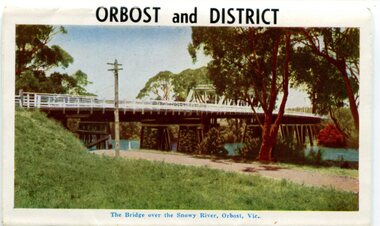 Orbost & District Historical Society
postcard series, 1960s
Included are photographs of the Orbost township, the Snowy River at Marlo, Gypsy Point, Buchan Caves and Bairnsdale. In the 1960s Orbost had a population of 4000 and was a major tourist attraction in Eastern Victoria with sufficient accommodation and facilities. It was the major town close to several national parks with access to either the surf or the snow. These postcards are pictorial records of Orbost in the 1960s. Postcards are very interesting records of places. architecture and transport.A colour postcard series with photographs of Orbost and the district. The cover photograph is of the Snowy River Bridge. There is an information card.Each photograph is labelled. at the bottom.postcards-orbost postcards-east-gippsland -
 Lakes Entrance Regional Historical Society (operating as Lakes Entrance History Centre & Museum)
Photograph, Rev John Flynn, 1906
Photographic proof on light cardBlack and white photograph of Snowy River from top of Turnback Mountain VictoriaValley of the Snowywaterways -
 Flagstaff Hill Maritime Museum and Village
Furniture - Table, Ralph Speirs, Warrnambool Triton Woodwork Club, 2009
The turpentine timber used to construct this table was originally used to build the second Hopkins River bridge in 1895. That long timber truss road bridge was built across the river close to the river mouth. The first Hopkins River bridge was built in 1862. That bridge was replaced by the second bridge, built in 1895. In 2001 the new third bridge was built to replace the 1895 bridge, in a design to look similar to the 1895 bridge. The timber from the second bridge was recycled to make this hall table, a cheeseboard presented to the Mayor at that time, and other mementos. The plaque attached to the table states the table was made in 2009 by Ralph Speirs, Warrnambool Triton Woodwork Club. The table is significant for its connection with the second Hopkins River bridge, built in 1895. The timber used to make the table has been recycled from the second Hopkins River bridge that was destroyed to make way for the new, third bridge. The Timber Truss Hopkins River Bridge was classified with State Significance on 16th April 1996, being the oldest of six surviving timber truss bridges in Victoria and the most intact timber road bridge of any type for its size and age. Its design was unique within Australia. It was the largest timber bridge built in Victoria during the 1890s. The bridge was of importance to the economical development of the region, opening up access to allow ease of trade and social connections between the eastern region of southwest Victoria and the town, later city, of Warrnambool and regions further west.Table made from turpentine timber. The timber was recycled from the second Hopkins River Bridge after the bridge was destroyed. The bridge was built in 1895. The table was constructed in 2009 by Ralph Speirs, Warrnambool Triton Woodwork Club. The front corners of the table are rounded and bthe back corners are straight. A plaque with eight rows of text is attached to the table."TABLE BUILT FROM TURPENTINE TIMBER RECYCLED FROM THE SECOND HOPKINS RIVER BRIDGE, BUILT IN 1895 AND DEMOLISHED IN 2000 TO BE RPLACED BY THE PRESENT THIRD BRIDGE. CONSTRUCTION BY RALPH SPEIRS, MEMBER OF WARRNAMBOOL TRITON WOODWORK CLUB, IN 2009"flagstaff hill, warrnambool, hopkins river, bridge, 1895, 2009, ralph speirs, warrnambool triton club, domestic furniture, table, hall table, side table, timber table, hall stand, furniture -
 Greensborough Historical Society
Photograph - Digital image, Frank Robinson, Greensborough near Plenty River bridge and football ground, 1954_
Greensborough near Plenty River bridge and football ground. The Blackjack property, house and acres of fruit orchards ran down to the Plenty River off Hume Street Greensborough and was the home of the Robinson family to late 1956. The photographs were taken as slides by Frank Robinson and digitised by his son James in 2015.Digital copy of colour photograph.robinson family, plenty river, blackjack -
 Flagstaff Hill Maritime Museum and Village
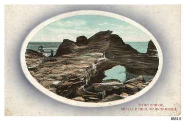
Postcard - Scenic, Warrnambool, Titan Bridge, Shelly Beach, Warrnambool, 1902-1929
The nine postcards in this set were donated together and date to the early 1900s. All but one postcard in this set shows images of Warrnambool, in the Western District of Victoria; the other has a London image. The postcards were all printed in Great Britain according to that country’s postal regulations. The fronts of all cards have titles printed in red. Most of the images on the cards are attributed to photographer Joseph Jordan and belong to the Jordan Series. The back of these cards has an outline for a postage stamp, a vertical dividing line and a heading on each side of the line to separate the Correspondence from the Address. Postcards or ‘correspondence cards’ appeared in Britain in 1894. They were plain cards with a space for the message on one side and an address on the other; regulations didn’t allow anything but the address to be written on the ‘address’ side. In 1902 the British regulations then allowed a picture to be printed on the front and the address on the back, so messages had to be written on the picture side. Soon, the regulations changed and the back was divided for a message and the address. Titan Bridge, Warrnambool – The name Titan Bridge is likely to be a reference to the huge Titan crane that was used in the construction of the Breakwater in the late 19th century. Shelly Beach is a popular swimming area with the added attraction of rock pools to investigate and rock formations to climb. Joseph Jordan - Joseph Jordan was born in 1841 in Leicester England. When he was 16 he joined the 7th Queen's Own Hussars and was sent to India at the outbreak of the mutiny. He took part in the relief of Lucknow and remained in India for eleven years. It was during this time that he became interested in photography. He was posted to New Zealand and later came to Victoria, becoming a sergeant major of the Mounted Rifles. In the mid-1880s he came to the Western district where he was responsible for establishing units of the Mounted Rifles in various country towns such as Dunkeld, Mortlake, Panmure, Bushfield, Koroit etc. He resigned from the army in 1889 and set up a professional photography studio in Liebig Street, Warrnambool. He became very well known in the Western District for family photographs, official photographs of local councillors and groups as well as views of local scenery. In 1891 he photographed the wrecked barque ‘Fiji’ at ‘Wrecks Beach’ near Princetown. His business was taken over by his son Arthur around 1917. Joseph was a keen rifle shot and in 1924 he donated the "Jordan Shield" as a prize to the Victorian Rifle Association. He was made a "Life Honorary Member" of the Warrnambool Returned Soldiers League and in 1933 he was recognised as being the oldest living soldier in Victoria. Joseph died in 1935 aged 95.The image of the Titan Bridge rock formation with figures on it suggests that the location was a popular place to visit. It captures a time when the rock formation was publically accessible. The choice of subject for this postcard indicates the popularity of Warrnambool's natural environment as a tourist attraction at a time when ships called coastal traders brought passengers and cargo to the Port of Warrnambool from ports along Victoria's southwest coast. Joseph Jordan is a significant figure in Warrnambool history as he helped to establish early units of the Mounted Rifles (G Company) in local towns during the late 1880's and later, photographed local scenes, groups and citizens of early Warrnambool.Postcard, one of nine, landscape orientation, coloured print within an oval border and mauve-toned shading. The cameo image shows two figures, one seated and one standing, beside the sea on a rough rock beside a rock formation resembling a bridge. There is no correspondence written on the card. The back has inscriptions and outlines for a postage stamp. Jordan Series, printed in Great Britain.Front, in red: “TITAN BRIDGE / SHELLY BEACH, NEAR WARRNAMBOOL” Back in black: “Jordan Series” “POST CARD” “PRINTED IN GREAT BRITAIN” “For correspondence” “The Address only to be written here”flagstaff hill maritime museum, flagstaff hill maritime village, flagstaff hill maritime museum and village, maritime museum, warrnambool, great ocean road, warrnambool and district, warrnambool scenes, local scenes, views of warrnambool, joseph jordan, jordan series, jordan photography, postcard, souvenir, correspondence, cameo postcard, landscape, shelly beach, titan bridge, titan, rock formation -
 Ballarat Heritage Services
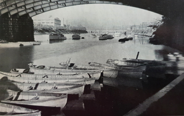
Photograph - Image, Below Princes Bridge, Melbourne
The Yarra River flows through Melbourne, the capital of Victoria. Photograph of the Princes Bridge on the Yarra River, Melbourne.melbourne, yarra river, princes bridge -
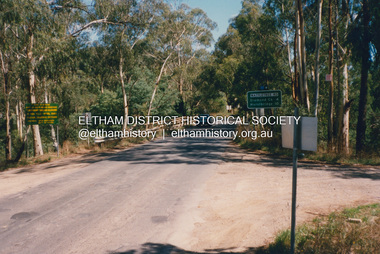
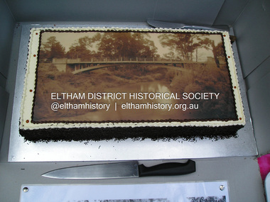 Eltham District Historical Society Inc
Photograph, Fay Bridge, Centenary celebration, Monash Bridge, Hurstbridge, 7 November 2017
The area of Hurstbridge was originally known as Hurst’s-bridge after the timber bridge built over the Diamond Creek near Hurst’s station in late 1881/early 1882. It was replaced by a new concrete bridge designed by Sir John Monash over the Diamond Creek near Hurst's home of 'Mia Mia' at Hurstbridge. The official opening of the new Monash bridge at Hurstbridge was held 3 November 1917.fay bridge collection, 2017-11-07, hurstbridge, hurstbridge heritage trail, monash bridge, ruins -
 Greensborough Historical Society
Photograph - Digital image, Frank Robinson, Looking north over the football ground with bridge over Plenty River, 1954_
Looking north over the football ground with bridge over Plenty River. The Blackjack property, house and acres of fruit orchards ran down to the Plenty River off Hume Street Greensborough and was the home of the Robinson family to late 1956. The photographs were taken as slides by Frank Robinson and digitised by his son James in 2015.Digital copy of colour photgraph.robinson family, blackjack, plenty river -
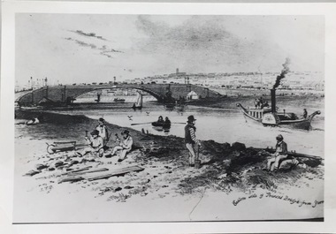 Kew Historical Society Inc
Photograph - Photograph (copy), S T Gill, Eastern side of Princess Bridge From Yarra, 1860-1880 (original)
Copy of a painting (or etching) by S.T. Gill showing the Yarra River at Princess Bridge, Melbourne.Inscription reverse: "Eastern side of old Princess Bridge from Yarra"reproductions -- s t gill, princess bridge -- river yarra - melbourne (vic.) -
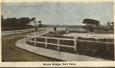 Port Fairy Historical Society Museum and Archives
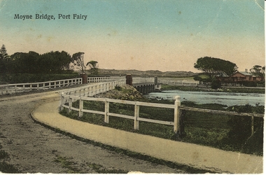
Photograph - Postcard, Moyne bridge
Photograph hand tinted of the Moyne river road bridge taken from Gipps Street showing house on the far bank on the right side taken for use as a PostcardMoyne Bridgemoyne bridge 1910, moyne river, traffic, gipps street -
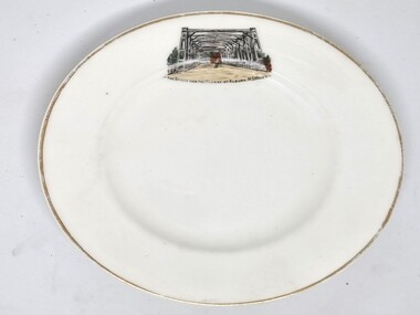
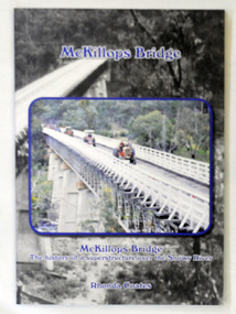 Orbost & District Historical Society
book, McKillops Bridge, 2014
This book was purchased new by Orbost & District Historical Society. Written by Buchan historian, Rhonda Coates, the book was commissioned by Tubbut Neighbourhood House following a commemoration event in 2002 when many people gathered for a special day organised by Sister Helen Barnes and the Tubbut community. (ref. Bombala Times)This book is a useful research item.A paper back book, titled McKillops Bridge, written by Rhonda Coates. On the front cover is a photograph tractors crossing the bridge during the Great Snowy River Tractor Stampede ( The Snowy River Tractor Strampede, a 560-kilometre journey, is organised by the Bega and District Historical Machinery Club every January - the first being held in 2009.) this photograph is inset over an earlier phpotograph by Howard Bulmer c 1936. The book contains the history of the bridge, photographs of the bridge and times before its construction.On front fly-Orbost &District Historical Society Incmckillops-bridge -
 Ballarat Heritage Services
Photograph - Digital photographs, L.J. Gervasoni, Hopkins River Mouth in flood, c2010 - 2017
The flooded Hopkins River flows into the sea at Warrnambool.hopkins river, mouth, point ritchie, bluehole, warrnambool, coast, coastal, beach, seascape, flood -
 Ballarat Heritage Services
Digital photographs, L.J. Gervasoni, Hopkins River Mouth in flood as the waters receed, c2010 - 2017
Colour photograph of the mouth of the Hopkins River at Warrnambool,hopkins river, mouth, point ritchie, bluehole, warrnambool, coast, coastal, beach, seascape, flood, post flood, geology, coastal geomorphology, waters receeding -
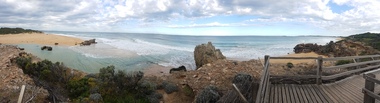
 Ballarat Heritage Services
Digital photographs, L.J. Gervasoni, Hopkins River Mouth - panorama, c2010 - 2017
Panoramic photograph of the mouth of the Hopkin's River at Warrnambool.hopkins river, mouth, point ritchie, bluehole, warrnambool, coast, coastal, beach, seascape, coastal geomorphology, pano -
 Ballarat Heritage Services
Digital photographs, L.J. Gervasoni, Hopkins River Mouth - panorama, c2010 - 2017
Colour photograph of the mouth of the Hopkins River, Warrnambool.hopkins river, mouth, point ritchie, bluehole, warrnambool, coast, coastal, beach, seascape, coastal geomorphology, pano -
 Port Fairy Historical Society Museum and Archives
Photograph - Postcard, Moyne Bridge, Port Fairy
Hand tinted photograph of Moyne river road bridge taken looking East showing house on Griffith street on the right side in the background taken for use as a PostcardMoyne River, Port Fairymoyne bridge, 1910, river, road, gipps street -
 Wodonga & District Historical Society Inc
Souvenir - Souvenir Plate - Union Bridge, Albury, Hancock and Sons, c1930s
This item is from a collection donated by descendants of John Francis Turner of Wodonga. It is one of many souvenirs produced to represent landmarks in the Albury-Wodonga district. The first punt across the Murray River at Albury was established by Robert Brown in 1843. In 1861 the first Union Bridge was built. It was demolished to make way for the second Union Bridge which opened in 1898. This second bridge closed and was eventually demolished after the third and existing bridge was opened in 1961. Hancock and Sons, Stoke on Trent - Sampson Hancock, a prominent Wesleyan Methodist, started potting in 1857. In 1891 he established the business of Sampson Hancock & Sons. Sampson died in 1900 and the business was continued by his three sons - Jabez, Harry and Arthur. In 1935 the business was in financial difficulty and was made bankrupt. It was restarted as S Hancock & Sons (Potters) Ltd. and moved to the Gordon Works, Hanley - which was renamed the Corona Works. The restarted company was not a success and it finally closed in 1937, having been put into receivership on 23rd March. This information helps to establish provenance of this plate.This item comes from a collection used by a prominent citizen of Wodonga. It is representative of a items produced to represent historic landmarks or features of the district.Fine China round plate with gilt edge and image of the Union Bridge, AlburyBeneath image: " THE BRIDGE OVER THE MURRAY AT ALBURY, NSWALESalbury souvenirs, union bridge albury, albury-wodonga border, murray river bridges -
 Eltham District Historical Society Inc
Photograph, Fay Bridge, Wattletree Road Bridge, Eltham, c.Jan. 1990
Shows Eltham Council sign notifying temporary closure of the bridge 19 Feb to 27 April 1990 for redecking. Illustrates the timber decking of the bridge and pedestrian footbridge extension on southern side.fay bridge collection, 1990-01, wattletree road bridge -
![The Fairfield Bridge [circa 1891]](/media/collectors/550653872162f11fb04854aa/items/579eab98d0cdd117c4af1c89/item-media/579eac23d0cdd117c4afb1ad/item-fit-380x285.jpg) Kew Historical Society Inc
Kew Historical Society IncPrint, The Fairfield Bridge [circa 1891], c. 1891
This work forms part of the collection assembled by the historian Dorothy Rogers, that was donated to the Kew Historical Society by her son John Rogers in 2015. The manuscripts, photographs, maps, and documents were sourced by her from both family and local collections or produced as references for her print publications. Many were directly used by Rogers in writing ‘Lovely Old Homes of Kew’ (1961) and 'A History of Kew' (1973), or the numerous articles on local history that she produced for suburban newspapers. Most of the photographs in the collection include detailed annotations in her hand. The Rogers Collection provides a comprehensive insight into the working habits of a historian in the 1960s and 1970s. Together it forms the largest privately-donated collection within the archives of the Kew Historical Society.A reproduction of a photograph of the Fairfield Bridge. The bridge was one of the first constructed for the Outer Circle Railway in 1891. Its supervising engineer was [Sir] John Monash. The bridge was later to be repurposed as a road linking the Chandler Highway to Fairfield."Outer Circle Railway Bridge over River Yarra at Fairfield (last section of line opened 1891)"fairfield bridge, chandler highway bridge, dorothy rogers, john monash, outer circle railway -
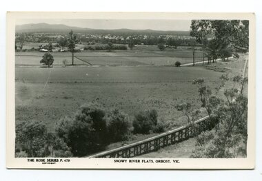 Orbost & District Historical Society
black and white photograph, Rose Stereograph Company, first half 20th century
The two bridges on the railway viaduct, which crosses the Snowy River floodplain at Orbost, were built from local Southern Mahogany. The bridge on the Bairnsdale end (770m) is now the longest in Victoria. Despite various attempts to extend the line, the station stayed on the western side of the Snowy River. (info. Helen Martin)This item is associated with the history of the Orbost-Bairnsdale railway line and therefore reflects the role that the rail line played in the social and economic history of Orbost.A black / white photograph / postcard of the Orbost township in the background and the railway viaduct over the flats in the foreground.photo caption - The Rose Series P.479 copywright SNOWY RIVER FLATS, ORBOST, VIC"east-gippsland-railway orbost-viaduct -
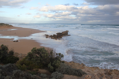
 Ballarat Heritage Services
Digital photographs, L.J. Gervasoni, Hopkins River Mouth, c2010 - 2017
Three colour photographs of the mouth of the Hopkins River at Warrnambool.hopkins river, mouth, point ritchie, bluehole, warrnambool, coast, coastal, beach, seascape -
 Ballarat Heritage Services
Digital photographs, L.J. Gervasoni, Hopkins River Mouth blocked, c2010 - 2017
Colour photograph of the blocked mouth of the Hopkin's River at Warrnambool.hopkins river, mouth, point ritchie, bluehole, warrnambool, coast, coastal, beach, seascape, blocked -
 Ballarat Heritage Services
Digital photographs, L.J. Gervasoni, Hopkins River Mouth - panorama, c2010 - 2017
Colour photograph of the mouth of the Hopkin's River at Warrnambool, Victoria. hopkins river, mouth, point ritchie, bluehole, warrnambool, coast, coastal, beach, seascape, coastal geomorphology, pano -
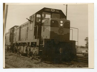 Orbost & District Historical Society
black and white photographs, August 21 1987
These photographs are of the final train to leave Orbost railway Station on August 21 1987 signalling the closure of the line. 3105.12 shows Locomotive T408 and on the side is written "LAST TRAIN EX ORBOST 24.8.87". These photographs are associated with the history of the Orbost-Bairnsdale railway line and therefore reflects the role that the rail line played in the social and economic history of Orbost. The closure of the line was a significant event in Orbost's history.Fifteen black / white photographs of the last train to leave Orbost Railway station.3105.1 - on back - "Last Train leaving Orbost Railway Station on Friday August 21. 1987. SRM August 26 1987 Last train from Orbost, Friday last saw the end of an era when the last freight train to pull out of Orbost Station at about 4.co pm. A symbolic wave from engineer, Bill Buckley, was the only ceremony to mark the passing of rail transport for East Gippsland." 3105.2 - on back - " Last train prepares to leave from Orbost on August 21, 1987." 3105.3 - on back - " The Orbost railhead following the departure of the last train on Friday August 21, 1987. Shows spectators who farewelled the last train." 3105.4 - on back - "From Grandview, Newmerella, shows the last train from Orbost crossing the timber Trestle (sic) viaduct across the Snowy River flats on Friday August 21, 1987" 3105.5 - on back - " A pair of Series 3 "T" Class Diesel Electric locomotives which were used to haul the final train from the Orbost Rail Head on Friday, August 21, 1987. Goods shed on right" 3105.6 - on back - " VFTY Timber Wagons at the Orbost Railway Station. 30 of these large wagons were built for the timber traffic between Orbost and Melbourne. Part of last train to leave Orbost on August 1, 1987." 3105.7 - on back - "The Fordson powered Rail Tractor which was used during shunting at the Orbost railway station, hooked up behind the second locomotive for its final journal from Orbost on Friday August 21, 1987." 3105.8 - on back - "Two Series 3 "T" Class Locomotives (Diesel Electric) were used to haul the final train from Orbost - T408 and T347, T408 was the leading locomotive. Orbost Goods Shed is on the left. Last train left on Friday August 27, 1987." 3105.9 - on back - " 3 "T" Class Diesel Electric locomotives often used in pairs to haul the timber trains out of Orbost. This locomotive was used to lead (haul) the final train from Orbost on Friday August 21, 1987" 3105.10 - on back - "The Gantry at the Orbost Railway Yards - capacity 10 tons. The last wagons before being hooked up to the locos for their last trip out of Orbost on Friday August 21, 1987" 3105.11 - on back - " Station Masters Office and Goods Shed at Orbost Railway Station. The two Series 3 "T" Class Diesel Electric locomotives waiting to haul the final train from Orbost on Friday 21 1987" otrbost-bairnsdale-railway east-gippsland-railway orbosr-railway-closure -
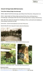 Greensborough Historical Society
Document - Submission, Norm Colvin et al, Banyule Heritage Study 2020 Nominations - Plenty River railway bridge Greensborough, 2020
Part of the single track railway extension of 1902 from Heidelberg to Eltham, the Plenty River railway bridge Greensborough, was nominated for the Banyule Heritage Study 2020. This nomination was prepared by Norm Colvin & Anne Paul on behalf of the Greensborough Historical Society1 p. Text and photographshurstbridge rail line, plenty river, banyule heritage study 2020 -
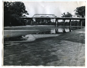 Orbost & District Historical Society
black and white photographs, 1937
These photographs are of the bridge across the Snowy River at Orbost which was replaced in 1976. This bridge over the Snowy River was opened on July 4 1922. It was constructed in 1922 alongside the previous suspension bridge. Its building was a combined effort of the Victorian Railways and the Country Roads Board at a cost of 35,000 pounds. It was replaced in 1976 by the present bridge after several major floods.This bridge was replaced in 1976 after several major floods. This is a pictorial record of that bridge.Three black / white photographs of a truss bridge across a river.bridge-snowy-river orbost-bridge-1937 -
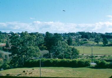
 Eltham District Historical Society Inc
Photograph, Shire of Eltham, New bridge over the Plenty River, Lower Plenty, Nov. 1966
Newly constructed single span bridge on Main Road (now Lower Plenty Road) crossing the Plenty River at Lower Plenty. Site of Heidelberg Golf Club and Lower Plenty Hotel in the background. This was the boundary between the Shire of Eltham and the City of Heidelberg.This photo forms part of a collection of photographs gathered by the Shire of Eltham for their centenary project book ,"Pioneers and Painters: 100 years of the Shire of Eltham" by Alan Marshall (1971). The collection of over 500 images is held in partnership between Eltham District Historical Society and Yarra Plenty Regional Library (Eltham Library) and is now formally known as 'The Shire of Eltham Pioneers Photograph Collection.' It is significant in being the first community sourced collection representing the places and people of the Shire's first one hundred years.Digital imagesepp, shire of eltham pioneers photograph collection, lower plenty, bridge -
 Eltham District Historical Society Inc
Photograph, Fitzsimons Lane Bridge over Yarra River between Eltham and Templestowe, c.1966, 1966c
Originally Fitzsimons Lane was the name of the road on the Templestowe side of the Yarra River; on the Eltham side it was known as the Eltham-Templestowe Road. When the new bridge was built the divided road was not continued in the Shire of Eltham as it would have required a significant widening of the cutting.Black and white photographManufacturer's marks: Polaroid, Batch #J62K181 (Sep 1966).infrastructure, shire of eltham infrastructure, bridge, fitzsimons lane bridge, polaroid, yarra river -
 Eltham District Historical Society Inc
Photograph, Fitzsimons Lane Bridge over Yarra River between Eltham and Templestowe, c.1966, 1966c
Originally Fitzsimons Lane was the name of the road on the Templestowe side of the Yarra River; on the Eltham side it was known as the Eltham-Templestowe Road. When the new bridge was built the divided road was not continued in the Shire of Eltham as it would have required a significant widening of the cutting.Black and white photographManufacturer's marks: Polaroid, Batch #J62K181 (Sep 1966).infrastructure, shire of eltham infrastructure, bridge, fitzsimons lane bridge, polaroid, yarra river