Showing 473 items
matching water works
-
 Port Melbourne Historical & Preservation Society
Photograph - Under Port Melbourne Railway, Hobsons Bay Main Sewer, "Melbourne water supply", 1890s
Three black and white images taken from: "Melbourne water supply - sewerage schemes" Special edition of the "Building, engineering and mining journal" The operations of the Melbourne and Metropolitan Board of Works. (.03) Plate XXXI. Under Port Melbourne Railway, Hobsons Bay Main Sewer, Section No 3. This view was taken in compressed air, and shows shield doors in background with men placing extra htdraulic power in position. This view also shows the method of constructing with concrete blocks and iron centreing on which to build the upper portion of the sewer.engineering - board of works, built environment - civic, mmbw, sewer, melbourne and metropolitan board of works -
Port Melbourne Historical & Preservation Society
Plan - MMBW, Melbourne and Metropolitan Board of Works (MMBW), 1894 - 1895
... Melbourne Metropolitan Board of Works (MMBW) waste water... engineering - board of works sewerage mmbw melbourne and metropolitan ...Located on State Library Victoria (SLV) website by member Ray JelleyMelbourne Metropolitan Board of Works (MMBW) waste water (sewer) plans from 1894-95. Plan numbers 322, 331, 335, 564, 565, 575. Area bounded by Liardet St, East Esplanade, Foote St, Johns(t)on St and Hobsons Bay. Includes Gas works and Distillery.engineering - board of works, sewerage, mmbw, melbourne and metropolitan board of works -
Port Melbourne Historical & Preservation Society
Archive - Alan Mathews and family, 7 Jul 1964
The Mathews family have been in continuous ownership of 395 Howe Parade (was 8 Howe Parade until 1964 when addresses re-assigned), Port Melbourne from 1938 to the present (Sept 2019)Six folders of assorted documents relating to the life of Alan Mathews and his family. Documents relating to the purchase of residence on Howe Parade. Building and contents Insurance from Scottish Union and National insurance Co for 395 Howe parade. (Note the changed address.)built environment - domestic, banking, utilities - water, alan mathews, j e mathews, melbourne and metropolitan board of works, mmbw -
 Women's Art Register
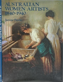
Book, Janine Burke, Australian Women Artists 1840 - 1940, 17/04/22
A history of Australian women artists, the lives and practice of 24 women are covered to redress their absence in critical and art historical records.non-fictionA history of Australian women artists, the lives and practice of 24 women are covered to redress their absence in critical and art historical records. painting, water colour, portraiture, print making -
Port Melbourne Historical & Preservation Society
Financial record - Payment advice, Melbourne Water Supply from Borough of Sandridge Council, 1880s
Payment advice for water from Melbourne Water Supply approved by public works committee, examined by finance committee, passed for payment by Sandridge Councilsport - lawn bowls, parks and gardens, port melbourne bowling club, henry norval edwards, michael tarver quinn, local government - borough of sandridge -
Port Melbourne Historical & Preservation Society
Document, Melbourne Water, Community Bulletin port Melbourne Pump Station Essential Works, Feb 2020 - Apr 2021
... Melbourne Pump Station Essential Works Document Melbourne Water ...Built c.1897, the pumps drain the larger Port Melbourne area to Port Phillip Bay. It was identified that the pumps were at the end of their serviceable life & would need to be renewed.Five Community Bulletins outlining the work to be done on the Port Melbourne Pumping Staion.pumping station, melbourne water -
 Royal Australian and New Zealand College of Obstetricians & Gynaecologists (RANZCOG)
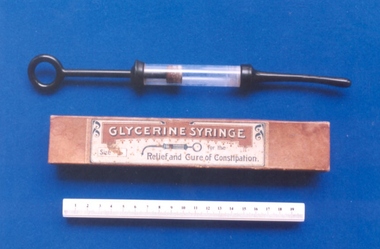
Rectal glycerin syringe with original box
Glycerin is used as a laxative. It works by causing the intestines to hold more water, which softens the stool. Glycerin rectal is used to treat occasional constipation or to cleanse the bowel before a rectal exam or other intestinal procedure. (https://www.drugs.com/mtm/glycerin-rectal.html)Metal and glass syringe with cork plunger [125.2], used for rectal irrigation. In original manufacturers box which is printed, "Glycerine Syringe"/ For the relief and cure of constipation". Box [125.3].constipation, irrigation -
Port Melbourne Historical & Preservation Society
Photograph - Renewal of storm water drain, Esplanade West, Port Melbourne, Janet Bolitho, Jul 2002
Five coloured photographs of renewal of storm water drain Esplanade West. .01 Esplanade East Street sign .02 Digging .03 Putting in pipe .04 large casing on end of crane .05 Workersbuilt environment - civic, engineering - canals and drainage, natural environment, sandridge lagoon, esplanade east, hmas lonsdale, stormwater drain, melbourne and metropolitan board of works -
 Bendigo Historical Society Inc.
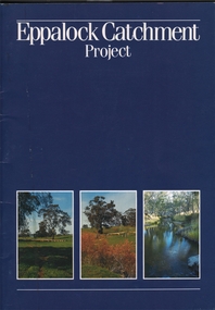
Book - EPPALOCK CATCHMENT PROJECT
27 pages booklet about the Eppalock Catchment Project - A soil conservation success story. Contents: Introduction; Before 1960; Environment; Extension; Planning and works; Implementation; Production; Eppalock-25 years on; What has the Eppalock Catchment Project demonstrated? Also with the book a 4 pages typewritten programme from the Soil Conservation Association of Victoria, Eppalock 25th Celebration, Ecumenical Thanksgiving Service, Sunday 13 October, 1985. at 11.45am - Mia Mia recreation Reserve.civil engineering, water supply, eppalock -
 Bendigo Historical Society Inc.
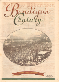
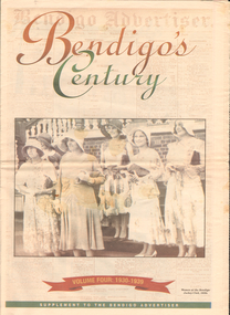
Newspaper - LONG GULLY HISTORY GROUP COLLECTION: BENDIGO'S CENTURY VOLUME THREE: 1920 - 1929
Newspaper supplement titled Bendigo's Century Volume Three: 1920 - 1929. Front page has a photo of The Duke and Duchess of York visit to Bendigo, 1927. Each year has heading of Who's Who, Weather, Sport and Business. First years are 1910 - 1919 titled The way we were. 1920 is titled Prince hailed. 1921 - City racks up a milestone. 1922 - Furore erupts. 1923 - Felons escape from city gaol. 1924 - Bid to finish RSL memorial. 1925 - Foul odour over sewerage plan. 1926 - Lest we forget Bendigo's fallen. 1927 - Royal Visit captures city. 1928 - Four shot in farm tragedy. 1929 - Billie's trip to remember.bendigo, history, long gully history group, the long gully history group - bendigo's century - volume three: 1920 - 1929, bendigo advertiser, duke and duchess of york, cr e m vains, r putnam, a j taylor, j h jackson, w crowley, sandhurst football club, george lansell, st peter's church, bendigo junior technical school, prince of wales, unity mine, mr w wilson, badak tin mining syndicate, mr t w ortonmr h scarborough, mr raleigh, general sir w r birdwood, the soldiers' memorial committee, bendigo city council, rsl memorial hall, captain g c wilson, lietenant r j parer, lieutenant j c mcintosh, cr j p carolin, h k morris, e a morris, turf tavern hotel, rev donald baker, all saints' pro--cathedral, keck's nursery, bendigo amalgamated goldfields, rising sun hotel, leanne mcdonnell, most rev john mccarthy, sir john quick, prime minister billy hughes, state rivers and water supply commission, diptheria, edna stevens, bendigo railway workshops, watson sustenance fund, sir joseph cook, dr lanza, bendigo amalgamated goldfields, bendigo benevolent asylum, miner's phthisis, bendigo gas company, electric light company, bendigo sewerage authority, commonwealth bank, cr curnow, the earl of stradbroke, dame nellie melba, princess theatre, lt-col g hurry, h sw lawson, countess of stradbroke, clunes woollen mills, girton college, mrs polglaise, mrs kennedy, gold discovery memorial, cr m g giudice, victorian co-operative freezing company, bendigo brick and tile company, mr lawson, soldiers' memorial, windermere hotel, toni riley pharmacy, bendigo gaol, mr a a dunstan mla, new red white and blue mine, claude de vere, walter osborne, sir john and lady quick, jonathan smalley, bendigo advertiser, st paul's bells, mr t cambridge, epsom public hall, bendigo school of mines, major lansell, mr h s w lawson, cr david andrew, colonel hurry, mr s bruce, bendigo sewerage authority, eppalock weir scheme, bendigo football league, r s l memorial, major g v lansell, lempriere, mr s m bruce, sandhurst hotel, market square, big hill tunnel, bendigo football league, bendigo united cricket club, south bendigo rex, sacred heart cathedral, hercules mine, gillies, aids & appliance shop, anne caudle centre, fizelle & mulqueen, south new moon mine, bendigo sewerage authority, mr a a kelley, epsom sewerage works, white hills botanical gardens, mr j sternberg mlc, bendigo book of remembrance, bendigo football league, senator general drake-brockman, captain dyett, school of mines, handschin and romus, hanro (aust.) bendigo knitting mills, charles handschin, farmers' union, andrew sunstan mla, country progressive party, john allan, captain g j c dyett, eahlehawk ufs dispensary, data fundamentals, the duke and duchess of york, the hercules mine, cr j a michelsen, lansell family, bendigo agricultural society, huntly shire council, bendigo creek trust, south african war memorial, cr j h curnow, st paul's church of england diamond jubilee, bendigo chamber of commerce, bendigo freezing works, bendigo pottery, bendigo trotting club, new red white and blue mine, the conservatory, cr e g batchelder, hercules mine, billie rigby, bendigo railway station, travellers' aid society, eppalock weir, the state rivers and water supply commission, bendigo railway workshops, frank grove, cr curnow, electric supply company, state electricity commission, australian aero club, bendigo preserving company, jardine, busbridge, feeman, mr h pearce, bfl, fred wood -
 Bendigo Historical Society Inc.
Newspaper - LONG GULLY HISTORY GROUP COLLECTION: BENDIGO'S CENTURY VOLUME FOUR: 1930 - 1939
Newspaper supplement titled Bendigo's Century Volume Four: 1930 - 1939. Front page is titled Bendigo's Century and has a photo of some women at the Bendigo Jockey Club, 1930s. Each year has heading of Who's Who, Weather, Sport and Business. First years are 1930 - 1939 titled A look back when. The page has photos of the Eaglehawk Cricket Club's first A Grade cricket premier ship team (1932 - 1933)., The monument to the late Bendigo mining magnate Ernst Mueller in Rosalind Park, The Bendigo Stock Exchange in the early 1930's - pictured are L L Dungey, T Williams, M P Kelly, C Mueller, E Hommoloff, R Kelly, T H Busst, T Hall, R Trembath, E A Woolcock, and C Burridge, the Carshalton mine in 1936 and The Edith and G V Lansell Laboratory at the Bendigo Hospital. 1930 - a photo of St Andrew's Church, the sundial outside the RSL Memorial Hall, The late Monsignor Rooney and The late John Douse Langley. The Ironbark Mine was the top gold producer. 1931 - Radio station goes on air, 1932 - Sir John dies, 1933 Bodyline men come to town, 1934 - Heroic rescues, 1935 - Hospital's new wing opened, 1936 - King mourned, 1937 - Beehive store towers above, 1938 - Mining shows mixed results and 1939 - Outbreak of war sobering.bendigo, history, long gully history group, the long gully history group - bendigo's century - volume four: 1930 - 1939, eaglehawk cricket club, ernst mueller, the bendigo stock exchangel l dungey, t williams, m p kelly, c mueller e hommoloff, r kelly, t h busst, t hall, r tremabath, e a woodcock, c burridge, charshalton mine, edith and g v lansell laboratory, st andrew's church, rsl memorial hall, mr gordon carter, sir john monash, state electricity commission, cr r watson, colonel gt v lansell, empire press congress, bendigo advertiser, mr e j hogan, eppalock weir, lyric theatre, bendigo red cross, mrs george mackay, st andrew's presbyterian church, mrs william hunter, right rev john douse langley, monsignor rooney, bendigo art gallery, the ironbark mine, coliban water, mr w wright, station 3bo, amalgamated wireless of australia ltd, advance bendigo group, the north league, st aidan's orphanage, bendigo freezing works, mr w wright, bendigo advertiser, mr w j stephens, advance bendigo group, north league, garden gully united gold mining company, bendigo football league, sir john quick, john quick snr, ironbark foundry, bendigo evening news, bendigo independent, bendigo advertiser, deakin governmnet, sir charles kingsford smith, southern cross, eppalock weir, bendigo art gallery, the hercules mine, gillies, aids & appliance shop, anne caudle centre, bill woodfull, harold larwood, dr john mccarthy, the hercules, douglas jardine, don bradman, sacred heart cathedral, joseph stapleton, john lynch, bert mcconchie, new red white and blue mine, royal humane society, william james, vernon shaw, south new moon mine, bendigo hospital, bendigo base hospital, duke of gloucester, rsl memorial hall, electricity commission, eaglehawk borough council, the plaza, backhaus estate, amalgamated freezing company, fortuna villa, mrs edith lansell, colonel lansell, the hercules mine, toni riley pharmacy, boardwalk, barkly hyett, the big blue consolidated company, the bendigo hospital, eaglehawk football team, kurmala wing of the bendigo base hospital, sir isaac isaacs, lyric theatre, sir john quick, hanro knitting mills, st luke's toddlers home, st aidan's orphanage, rsl memorial hall, lord and lady huntingfield, cr michelsen, bendigo art gallery, bendigo agricultural show, new blue mine, joseph stapleton, bendigo law association, bendigo hospital committee of management, bendigo rotary club, mr j mcrae, education department, andrew sunstan, sir stanley argyle, bendigo football league, north blue mining company, cr staples, king george v, king edward viii, cr j a michelsen, andrew mclay, bendigo advertiser, cohn bros, mrs wallis simpson, king george vi, capping mine shafts 1936, bendigo art gallery, madge freemen, william john leslie cross, judge wasley, the myer emporium, the baptist church, salvation army, ron masters, the central nell gwyn, sir john quick, leanne mcdonnell, windermere hotel, rev donald baker, john rumbold, central nell gwynne, the beehive building, the beehive store, james buick and co, thomas hope henderson, buick henderson & co, mr goodison, mr r o henderson, lt-col henderson, angus mackay, bendigo sewerage authority, mr s gordon moore, commercial bank of sydney, bendigo advertiser, edward alan morcom, polio, dr gardner kerr, the right rev conald baker, ridley theological college -
 Bendigo Historical Society Inc.
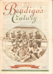
Newspaper - LONG GULLY HISTORY GROUP COLLECTION: BENDIGO'S CENTURY VOLUME FIVE: 1940 - 1949
Newspaper supplement titled Bendigo's Century Volume Five: 1940 - 1949. Each year has heading of Who's Who, Weather, Sport and Business. Front page is titled Bendigo's Century and has a photo of a group of soldiers in uniform and with rifles. They were district servicemen on leave in 1944. Each year has heading of Who's Who, Weather, Sport and Business. First years are 1940 - 1949 titled Bendigo as it was. It has two photos of women wading through the 1949 Pall Mall flood waters and one of Miners in the crib room of the Central Deborah Mine. They are Jackie Lewis, Bob Johnson, W Landy, Ryga Yates and Les Johnson. 1940 - Army moves in to racecourse, 1941 - Devastating fire at pottery, 1942 - Forces expand, 1943 - Nation's eyes on Bendigo, 1944 - News dawns of D-day landing, 1945 - City cheers the end of the war, 1946 - Celebrations begin in city, 1947 - Gallery gets top paintings, 1948 - Water plan looks good and 1949 - Flood takes a toll on city.bendigo, history, long gully history group, the long gully history group - bendigo's century - volume five: 1940 - 1949, bendigo advertiser, central deborah mine, jackie lewis, bob johnson, w landy, ryga yates, les johnson, central nell gwynne, department of defence, bendigo jockey club, 8th division, robert menzies, deborah mine, bendigo decentralisation vigilance committee, cr w h taylor, bendigo war funds organisation, the easter fair society, bendigo agricultural show committee, mr e g ham, mr j v fairbairn, cr a staples, the bendigo chamber of commerce, richard hartley smith abbott, captain harley abbott, bendigo art gallery, bill woodfull, bendigo high school, north deborah mine, boardwalk, toni riley pharmacy, windermere hotel, cr g a pethard, coliban system, north deborah mine, bendigo pottery, bendigo trades hall council, private lawrence burstall, major-general g j rankin mhr, andrew dunstan, ordnance factory, royal australian navy, hmas bendigo, sec offices, muioof, ymca, georger addlem, fred addlem, cr a j anderson, pauline buvhan thompson, leslie thompson, edward joseph leonski, bendigo football league, mr j dedman, william stephens, forest street methodist church, pte charles phillips, pte w e durward, pte t foley, william john stephens, central nell gwynne, air chief marshall sir arthur tedder, cr taylor, united nations, flying officer, r bruce tuff, flight lieutenant owens, royal air force, commonwealth war workers housing trust scheme, mr s mckinnon, bendigo decentralised vigilance committee, ravenswood estate, john lienhop mlc, margaret (peggy) brennan, strathfieldsaye shire council, school of mines, bendigo base hospital, william george ashman, ashman's tailors, bendigo jockey club, victorian football association, bendigo east swimming pool, deborah anticline, specimen hill methodist church, north deborah, adolf hitler, benito mussolini, australian 7th division, cr galvin, bendigo war funds organisation, hmas bendigo, lt-commander jackson, bendigo football league, central deborah mine, victoria day, cr truscott, bendigo gaol, lansellstowe, awas barracks, bendigo citizens committee, john cain snr, ordnance factory, bendigo agricultural society, the duke of gloucester, duchess of gloucester, bendigo tennis association, north deborah, gillies famous pies, aids & appliance shop, mrs georgina scott, dr j a neptune scott, alfred sisley, corot, daubigney, louis sonnenberg, gas employees' union, john lienhop, soldier settlement commission, burnewang estate, king george vi, princess elizabeth, lt philip mountbatten, mr e j w herbert, ansett airways, reg ansett, most rev, dr john mccarthy, dr bernard stewart, michael giudice, bendigo united breweries, bendigo lyric photo plays, bendigo sun newspaper, shamrock hotel, west bendigo progress association, alan mcdonald, south bendigo football club, albert collier, j t webbo, mervyn tresize, state rivers and water supply commission, eppalock reservoir, public works committee, bendigo rotary club, john edgar, bendigo base hospital, albert dunstan, benevolent home, magetti's wine hall, wallace reef wine hall, magetti family, albert magetti, lance galvin, bradford cotton spinnings (victoria) pty otd, arthur syer, stanley crossman, albert arthur dunstan, rev dr henry backhaus, city family hotel, lyric theatre, bank of australasia, city club hotelcolonial mutual building, r matchett & co, lansellstowe, leonard lansell, bendigo bas hospital, australian women's army service, mr hollway, kenworth (aust) ltd, foggitt jones's bacon factory, gordon sayers, sandhurst trustees, dr john drowley, alexander hislop, royal mint, north deborah mine, ironbark south mining company, central nell gwynne company, new chum syncline -
 Melbourne Water
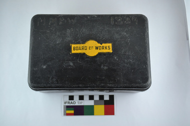
First Aid Kit (plastic lunch box), 1970s
... of works melbourne water first aid kit mmbw safety water sewerage ...As the Yarra became unsuitable as a source of water, several attempts were made to find alternative sources for the growing population of Melbourne. It was not until 1891 that the efforts to sewer Melbourne came to fruition with the setting up of the Melbourne Metropolitan Board of Works (MMBW), now known as Melbourne Water. From 1891 until 1992, it was the responsibility of the MMBW to safeguard public health by providing a sewerage system and a safe water supply system. In 1992, The MMBW merged with a number of smaller urban water authorities to form Melbourne Water.This first aid kit is of historical significance for its association with the former Melbourne and Metropolitan Board of Works (MMBW). The kit is relatively intact and a rare surviving object of standard Board issued equipment. The kit is significant for its representativeness of the theme of Safety that continues to resonate strongly within Melbourne Water today. First Aid Kit (plastic lunch box)MMBW 1339 (burnt into plastic) Board of Works Decalmelbourne metropolitan board of works, melbourne water, first aid kit, mmbw, safety, water, sewerage -
 Melbourne Water
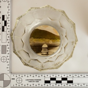
Souvenir confectionery bowl, 1930s-40s
Melbourne Water inherited many of its water assets, such as reservoirs from its predecessor the Melbourne Metropolitan Board of Works (MMBW). They have served the organisation well and have long been celebrated for both their natural beauty and engineering ingenuity. In the nineteenth century Victoria’s fundamental need for water infrastructure went beyond merely functional solutions and reflected the English ideal of the romance and beauty that was embodied in expanses of water. The MMBW further enhanced this notion by incorporating beauty and function in to the Classical and Italianate designs of its infrastructure such as pumping houses and reservoir outlet towers. The reservoir gardens and picnic areas were landscaped with ornamental stonework, exotic trees, decorative flower beds, fern glades pools and rose gardens. All features of the water supply system became widely celebrated as beauty spots that continue to be very popular to this day with tourists and locals alike. This souvenir is a product of that flourishing tourist trade. These water supply sites continue to enhance Melbourne’s charm and liveability and are now recognised as places of cultural and historic significance. This souvenir item has been curated by Melbourne Water as it represents an important historical aspect of the organisation by demonstrating the popularity of its water asset sites as recreational places and tourist attractions, and although these sites are functional parts of the water supply system, they were also designed to be enjoyed by the public both aesthetically and recreationally. Clear glass flower shaped 'depression ware' confectionery bowl, with photographic image of Maroondah Reservoir outlet tower on basemelbourne metropolitan board of works, mmbw, maroondah reservoir, melbourne water, scenic view, souvenir, glass bowl -
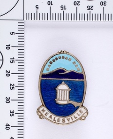 Melbourne Water
Souvenir lapel pin/brooch Maroondah Dam, 1960s/70s
Melbourne Water inherited many of its water assets, such as reservoirs from its predecessor the Melbourne Metropolitan Board of Works (MMBW). They have served the organisation well and have long been celebrated for both their natural beauty and engineering ingenuity. In the nineteenth century Victoria’s fundamental need for water infrastructure went beyond merely functional solutions and reflected the English ideal of the romance and beauty that was embodied in expanses of water. The MMBW further enhanced this notion by incorporating beauty and function in to the Classical and Italianate designs of its infrastructure such as pumping houses and reservoir outlet towers. The reservoir gardens and picnic areas were landscaped with ornamental stonework, exotic trees, decorative flower beds, fern glads pools and rose gardens. All features of the water supply system became widely celebrated as beauty spots that continue to be very popular to this day with tourists and locals alike. This souvenir is a product of that flourishing tourist trade. These water supply sites continue to enhance Melbourne’s charm and liveability and are now recognised as places of cultural and historic significance. This souvenir item has been curated by Melbourne Water as it represents an important historical aspect of the organisation by demonstrating the popularity of its water asset sites as recreational places and tourist attractions, and although these sites are functional parts of the water supply system, they were also designed to be enjoyed by the public both aesthetically and recreationally. Blue enamel and metal lapel pin/brooch depicting Maroondah Reservoir and outlet tower. Oval shaped with words 'Maroondah Dam' at the top and a ribbon banner containing 'Healesville' at the bottom. Maroondah Dam. Healesvillemelbourne metropolitan board of works, mmbw, maroondah reservoir, melbourne water, scenic view, souvenir, lapel pin, brooch -
 Melbourne Water
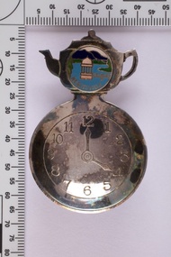
Souvenir tea caddy spoon "Tea Time", Early 1960s
Melbourne Water inherited many of its water assets, such as reservoirs from its predecessor the Melbourne Metropolitan Board of Works (MMBW). They have served the organisation well and have long been celebrated for both their natural beauty and engineering ingenuity. In the nineteenth century Victoria’s fundamental need for water infrastructure went beyond merely functional solutions and reflected the English ideal of the romance and beauty that was embodied in expanses of water. The MMBW further enhanced this notion by incorporating beauty and function in to the Classical and Italianate designs of its infrastructure such as pumping houses and reservoir outlet towers. The reservoir gardens and picnic areas were landscaped with ornamental stonework, exotic trees, decorative flower beds, fern glads pools and rose gardens. All features of the water supply system became widely celebrated as beauty spots that continue to be very popular to this day with tourists and locals alike. This souvenir is a product of that flourishing tourist trade. These water supply sites continue to enhance Melbourne’s charm and liveability and are now recognised as places of cultural and historic significance This souvenir item has been curated by Melbourne Water as it represents an important historical aspect of the organisation by demonstrating the popularity of its water asset sites as recreational places and tourist attractions, and although these sites are functional parts of the water supply system, they were also designed to be enjoyed by the public both aesthetically and recreationally. Tea caddy spoon with clock face engraved showing 4pm on round spoon, tea pot shaped handle with enamel scenic view badge saying 'Healesville' ( depicting Maroondah Reservoir outlet tower). Tea caddy spoon box labelled 'Fine Silverware by Stokes'Stokes and Sons Stokes & Sons logo (Star with S and boomerang) EG. No. 15733melbourne metropolitan board of works, mmbw, maroondah reservoir, melbourne water, scenic view, souvenir, tea caddy spoon -
 Melbourne Water
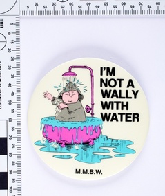
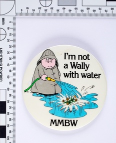
I'm not a Wally with Water badge, 1980s
Following the 1983 Victorian drought The Board of Works (MMBW) ran a television, radio and print campaign to encourage water conservation called ‘Don’t Be a Wally with Water’. The campaign followed Wally, a bumbling, habitual water waster, and is an early example of educating the public on water sustainability both environmentally and financially. Wally was both a cartoon character and played on television by the comedian Peter Moon. The campaign ran for several years and was designed to change attitudes towards water wastage. This MMBW branded item is associated with ‘Don’t Be a Wally with Water’ campaign, and demonstrates an early water sustainability education program. These badges would have been given out as promotional merchandise and at public events. Round metal badge with printed cartoon image and text. -
 Melbourne Water
Souvenir Manicure Set, ELOSI, Maroondah Dam, Healesville Souvenir, c.1940
The Maroondah System was first and foremost developed as a functional component of Melbourne's Water Supply System. In addition to functionality, the Melbourne and Metropolitan Board of Works (MMBW) envisioned the Maroondah Reserve to be enjoyed aesthetically and recreationally by the public. This souvenir illustrates the realisation of the Maroondah System as a local recreational and tourist attraction in the early 20th century. The Maroondah Reserve gardens were landscaped with English-style ornamental stonework, exotic trees, flower beds and rose gardens. All features of the water supply system became widely celebrated as beauty spots that continue to be very popular to this day with tourists and locals alike. This souvenir is a product of that flourishing tourist trade. These water supply sites continue to enhance Melbourne’s charm and liveability and are now recognised as places of cultural and historic significance.This souvenir item has been curated by Melbourne Water as it represents an important historical aspect of the organisation by demonstrating the popularity of its water asset sites as recreational places and tourist attractions, and although these sites are functional parts of the water supply system, they were also designed to be enjoyed by the public both aesthetically and recreationally. This rare pocket grooming kit features a scene of the Maroondah Outlet and Dam. The handle is manufactured from mother-of-pearl, encasing four steel utensils. The utensils contained inside the kit were used for filing and manicuring.Engraved on the back of the last utensil is the manufacturer’s mark “ELOSI”. ELOSI is the acronym from Ernest Lohr and Otto Stiehl of Solingen, Germany. In 1935, this company was the first to manufacture thin plastic covers for low cost (5-25 cents). This is one of the most successful and profitable inventions in the history of cutlery and utensils.melbourne metropolitan board of works, mmbw, maroondah, dam, healesville, melbourne water, scenic view, souvenir, manicureset, historic, germany, rare -
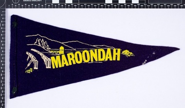 Melbourne Water
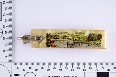
Souvenir Pennant
The Maroondah System was first and foremost developed as a functional component of Melbourne's Water Supply System. In addition to functionality, the Melbourne and Metropolitan Board of Works (MMBW) envisioned the Maroondah Reserve to be enjoyed aesthetically and recreationally by the public. This souvenir illustrates the realisation of the Maroondah System as a local recreational and tourist attraction in the early 20th century. The Maroondah Reserve gardens were landscaped with English-style ornamental stonework, exotic trees, flower beds and rose gardens. All features of the water supply system became widely celebrated as beauty spots that continue to be very popular to this day with tourists and locals alike. This souvenir is a product of that flourishing tourist trade. These water supply sites continue to enhance Melbourne’s charm and liveability and are now recognised as places of cultural and historic significance.This souvenir item has been curated by Melbourne Water as it represents an important historical aspect of the organisation by demonstrating the popularity of its water asset sites as recreational places and tourist attractions, and although these sites are functional parts of the water supply system, they were also designed to be enjoyed by the public both aesthetically and recreationally. Navy in colour, the pennant is double sided, with an image of the Maroondah Dam surrounding the word “Maroondah” on both sides.melbourne metropolitan board of works, mmbw, maroondah, dam, healesville, melbourne water, scenic view, souvenir, pennant, flag, textile, historic -
 Melbourne Water
I'm not a Wally with Water badge, 1980s
Following the 1983 Victorian drought The Board of Works (MMBW) ran a television, radio and print campaign to encourage water conservation called "Don't Be a Wally with Water". The campaign followed Wally, a bumbling, habitual water waster, and is an early example of educating the public on water sustainability both environmentally and financially. Wally was both a cartoon character and played on television by the comedian Peter Moon. The campaign ran for several years and was designed to change attitudes towards water wastage.This MMBW branded item is associated with "Don't Be a Wally with Water" campaign, and demonstrates an early water sustainability education program. These badges would have been given out as promotional merchandise and at public events.Round metal badge with printed cartoon image and text. -
 Melbourne Water
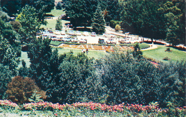
Postcard, The Car Park at Maroondah Reserve, c.1940
The Maroondah System was first and foremost developed as a functional component of Melbourne's Water Supply System. In addition to functionality, the Melbourne and Metropolitian Board of Works (MMBW) envisioned the Maroondah Reserve to be enjoyed aestethically and recreationally by the public. This souvenir postcard illustrates the realisation of the Maroondah System as a local recreational and tourist attraction in the early 20th century. The Maroondah Reserve gardens were landscaped with English-style ornamental stonework, exotic trees, flower beds and rose gardens. All features of the water supply system became widely celebrated as beauty spots that continue to be very popular to this day with tourists and locals alike. This souvenir is a product of that flourishing tourist trade. These water supply sites continue to enhance Melbourne’s charm and liveability and are now recognised as places of cultural and historic significance.This souvenir item represents an important historical aspect of the MMBW by demonstrating the popularity of its water asset sites as recreational places and tourist attractions, and although these sites are functional parts of the water supply system, they were also designed to be enjoyed by the public both aesthetically and recreationally. The souvenir postcard is significant for its documentation of the Maroondah Water Supply System developed through the late nineteenth and early twentieth century, shaping the formative years of Melbourne. The postcard is also historically significant for its association with the MMBW and is viewed as a noteworthy achievement of the organisation. Souvenir coloured rectangular postcard with a framed picture of the carpark at the Maroondah Reserve.melbourne metropolitan board of works, mmbw, maroondah reservoir, melbourne water, scenic view, souvenir -
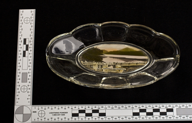
 Melbourne Water
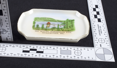
Dish, The Outlet at Maroondah Dam, Souvenir, c.1940
The Maroondah System was first and foremost developed as a functional component of Melbourne's Water Supply System. In addition to functionality, the Melbourne and Metropolitan Board of Works (MMBW) envisioned the Maroondah Reserve to be enjoyed aesthetically and recreationally by the public. This souvenir dish illustrates the realisation of the Maroondah System as a local recreational and tourist attraction in the early 20th century. The Maroondah Reserve gardens were landscaped with English-style ornamental stonework, exotic trees, flower beds and rose gardens. All features of the water supply system became widely celebrated as beauty spots that continue to be very popular to this day with tourists and locals alike. This souvenir is a product of that flourishing tourist trade. These water supply sites continue to enhance Melbourne’s charm and liveability and are now recognised as places of cultural and historic significance.This souvenir item represents an important historical aspect of the MMBW by demonstrating the popularity of its water asset sites as recreational places and tourist attractions, and although these sites are functional parts of the water supply system, they were also designed to be enjoyed by the public both aesthetically and recreationally. The souvenir dish is significant for its documentation of the Maroondah Water Supply System developed through the late nineteenth and early twentieth century, shaping the formative years of Melbourne. The dish is also historically significant for its association with the MMBW and is viewed as a noteworthy achievement of the organisation.Small white porcelain dish with silver trim, 120x75x10mm, with drawing printed in the centre and text reading, "The Outlet, Maroondah Dam, Healesville, Vic." Makers mark, Manufactured in Czechoslovakiamelbourne metropolitan board of works, mmbw, maroondah, outlet, melbourne water, scenic view, souvenir, porcelain, healesville -
 Melbourne Water
Glass Bowl, Maroondah Dam, Healesville Souvenir, 1930s -1940s
The Maroondah System was first and foremost developed as a functional component of Melbourne's Water Supply System. In addition to functionality, the Melbourne and Metropolitan Board of Works (MMBW) envisioned the Maroondah Reserve to be enjoyed aesthetically and recreationally by the public. This souvenir illustrates the realisation of the Maroondah System as a local recreational and tourist attraction in the early 20th century. The Maroondah Reserve gardens were landscaped with English-style ornamental stonework, exotic trees, flower beds and rose gardens. All features of the water supply system became widely celebrated as beauty spots that continue to be very popular to this day with tourists and locals alike. This souvenir is a product of that flourishing tourist trade. These water supply sites continue to enhance Melbourne’s charm and liveability and are now recognised as places of cultural and historic significance.This souvenir item has been curated by Melbourne Water as it represents an important historical aspect of the organisation by demonstrating the popularity of its water asset sites as recreational places and tourist attractions, and although these sites are functional parts of the water supply system, they were also designed to be enjoyed by the public both aesthetically and recreationally. Clear glass flower shaped 'depression ware' bowl with photograph of Maroondah Dam Healesville in the base.melbourne metropolitan board of works, mmbw, maroondah reservoir, melbourne water, scenic view, souvenir, glass, bowl -
 Melbourne Water
Glass Bowl, Maroondah Dam, Healesville Souvenir, 1930s - 1940s
The Maroondah System was first and foremost developed as a functional component of Melbourne's Water Supply System. In addition to functionality, the Melbourne and Metropolitan Board of Works (MMBW) envisioned the Maroondah Reserve to be enjoyed aesthetically and recreationally by the public. This souvenir illustrates the realisation of the Maroondah System as a local recreational and tourist attraction in the early 20th century. The Maroondah Reserve gardens were landscaped with English-style ornamental stonework, exotic trees, flower beds and rose gardens. All features of the water supply system became widely celebrated as beauty spots that continue to be very popular to this day with tourists and locals alike. This souvenir is a product of that flourishing tourist trade. These water supply sites continue to enhance Melbourne’s charm and liveability and are now recognised as places of cultural and historic significance.This souvenir item has been curated by Melbourne Water as it represents an important historical aspect of the organisation by demonstrating the popularity of its water asset sites as recreational places and tourist attractions, and although these sites are functional parts of the water supply system, they were also designed to be enjoyed by the public both aesthetically and recreationally. Glass bowl with a photograph of the Maroondah Dam in the middle, and text overlay reading "Maroondah Dam, Healesville". melbourne metropolitan board of works, mmbw, maroondah, dam, healesville, melbourne water, scenic view, souvenir, glass bowl -
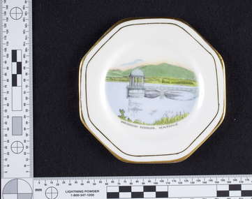 Melbourne Water
Dish, Maroondah Reservoir, Healesville Souvenir, 1930s-1940s
... metropolitan board of works, melbourne water, mmbw...Melbourne Water 990 La Trobe Street Docklands melbourne ...The Maroondah System was first and foremost developed as a functional component of Melbourne's Water Supply System. In addition to functionality, the Melbourne and Metropolitan Board of Works (MMBW) envisioned the Maroondah Reserve to be enjoyed aesthetically and recreationally by the public. This souvenir illustrates the realisation of the Maroondah System as a local recreational and tourist attraction in the early 20th century. The Maroondah Reserve gardens were landscaped with English-style ornamental stonework, exotic trees, flower beds and rose gardens. All features of the water supply system became widely celebrated as beauty spots that continue to be very popular to this day with tourists and locals alike. This souvenir is a product of that flourishing tourist trade. These water supply sites continue to enhance Melbourne’s charm and liveability and are now recognised as places of cultural and historic significance.Manufactured in England, this souvenir dish made from bone china with gold trim, features an illustration of the Maroondah Reservoir in the centre reading, “Maroondah Reservoir, Healesville”. On the back of the dish is the makers mark, Royal Stafford, one of the oldest pottery factories in Staffordshire, England. The Royal Stafford brand was established in 1845 and continues to provide high quality tableware in the present day. This souvenir item has been curated by Melbourne Water as it represents an important historical aspect of the organisation by demonstrating the popularity of its water asset sites as recreational places and tourist attractions, and although these sites are functional parts of the water supply system, they were also designed to be enjoyed by the public both aesthetically and recreationally. Souvenir dish made from bone china with gold trim, featuring an illustration of the Maroondah Reservoir in the centre reading, “Maroondah Reservoir, Healesville”.Makers mark, Royal Stafford.maroondah, healesville, dish, porcelain, melbourne metropolitan board of works, melbourne water, mmbw -
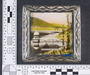
 Melbourne Water
Ashtray, Graceburn Weir, Healesville Souvenir, 1930s-1940s
The Maroondah System was first and foremost developed as a functional component of Melbourne's Water Supply System. In addition to functionality, the Melbourne and Metropolitan Board of Works (MMBW) envisioned the Maroondah Reserve to be enjoyed aesthetically and recreationally by the public. This souvenir illustrates the realisation of the Maroondah System as a local recreational and tourist attraction in the early 20th century. The Maroondah Reserve gardens were landscaped with English-style ornamental stonework, exotic trees, flower beds and rose gardens. All features of the water supply system became widely celebrated as beauty spots that continue to be very popular to this day with tourists and locals alike. This souvenir is a product of that flourishing tourist trade. These water supply sites continue to enhance Melbourne’s charm and liveability and are now recognised as places of cultural and historic significance.This souvenir item has been curated by Melbourne Water as it represents an important historical aspect of the organisation by demonstrating the popularity of its water asset sites as recreational places and tourist attractions, and although these sites are functional parts of the water supply system, they were also designed to be enjoyed by the public both aesthetically and recreationally.This Souvenir glass ashtray, used as a receptacle for ash from cigarettes, features a photograph of the Graceburn Weir on the base, with text reading “The Graceburn Weir, Healesville”. Rather small in size, this ashtray has a unique shape with four protruding glass points to place cigarettes. melbourne metropolitan board of works, mmbw, maroondah, dam, healesville, melbourne water, scenic view, souvenir, glass, ashtray, graceburnweir -
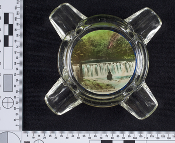
 Melbourne Water
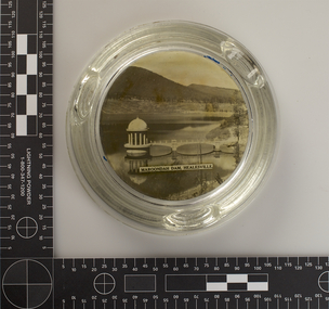
Ashtray, Maroondah Dam, Healesville Souvenir, 1930s-1940s
The Maroondah System was first and foremost developed as a functional component of Melbourne's Water Supply System. In addition to functionality, the Melbourne and Metropolitan Board of Works (MMBW) envisioned the Maroondah Reserve to be enjoyed aesthetically and recreationally by the public. This souvenir illustrates the realisation of the Maroondah System as a local recreational and tourist attraction in the early 20th century. The Maroondah Reserve gardens were landscaped with English-style ornamental stonework, exotic trees, flower beds and rose gardens. All features of the water supply system became widely celebrated as beauty spots that continue to be very popular to this day with tourists and locals alike. This souvenir is a product of that flourishing tourist trade. These water supply sites continue to enhance Melbourne’s charm and liveability and are now recognised as places of cultural and historic significance.This souvenir item has been curated by Melbourne Water as it represents an important historical aspect of the organisation by demonstrating the popularity of its water asset sites as recreational places and tourist attractions, and although these sites are functional parts of the water supply system, they were also designed to be enjoyed by the public both aesthetically and recreationally. This Souvenir glass ashtray, used as a receptacle for ash from cigarettes, features a black and white photograph of The Maroondah Dam on the base, with text reading “Maroondah Dam, Healesville”. The ashtray is round in shape with three indents on the rim to place cigarettes. melbourne metropolitan board of works, mmbw, maroondah, dam, healesville, melbourne water, scenic view, souvenir, glass, ashtray -
 Melbourne Water
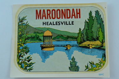
Maroondah, Healesville Souvenir Car Sticker
The Maroondah System was first and foremost developed as a functional component of Melbourne's Water Supply System. In addition to functionality, the Melbourne and Metropolitan Board of Works (MMBW) envisioned the Maroondah Reserve to be enjoyed aesthetically and recreationally by the public. This souvenir illustrates the realisation of the Maroondah System as a local recreational and tourist attraction in the early 20th century. The Maroondah Reserve gardens were landscaped with English-style ornamental stonework, exotic trees, flower beds and rose gardens. All features of the water supply system became widely celebrated as beauty spots that continue to be very popular to this day with tourists and locals alike. This souvenir is a product of that flourishing tourist trade. These water supply sites continue to enhance Melbourne’s charm and liveability and are now recognised as places of cultural and historic significance.This souvenir item has been curated by Melbourne Water as it represents an important historical aspect of the organisation by demonstrating the popularity of its water asset sites as recreational places and tourist attractions, and although these sites are functional parts of the water supply system, they were also designed to be enjoyed by the public both aesthetically and recreationally. Souvenir car sticker with a colourful design of Maroondah Dam in Healesville with car sticker instructions.melbourne metropolitan board of works, mmbw, maroondah, dam, healesville, melbourne water, scenic view, souvenir, sticker, car, instructions -
 Melbourne Water
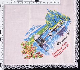
Handkerchief, Maroondah Dam, Healesville Souvenir, 1970s
The Maroondah System was first and foremost developed as a functional component of Melbourne's Water Supply System. In addition to functionality, the Melbourne and Metropolitan Board of Works (MMBW) envisioned the Maroondah Reserve to be enjoyed aesthetically and recreationally by the public. This souvenir illustrates the realisation of the Maroondah System as a local recreational and tourist attraction in the early 20th century. The Maroondah Reserve gardens were landscaped with English-style ornamental stonework, exotic trees, flower beds and rose gardens. All features of the water supply system became widely celebrated as beauty spots that continue to be very popular to this day with tourists and locals alike. This souvenir is a product of that flourishing tourist trade. These water supply sites continue to enhance Melbourne’s charm and liveability and are now recognised as places of cultural and historic significance.This souvenir item has been curated by Melbourne Water as it represents an important historical aspect of the organisation by demonstrating the popularity of its water asset sites as recreational places and tourist attractions, and although these sites are functional parts of the water supply system, they were also designed to be enjoyed by the public both aesthetically and recreationally. Pink handkerchief with lace trim. The handkerchief features a print of the Maroondah Dam, with text “Maroondah Dam. Greetings from Healesville Vic”. melbourne metropolitan board of works, mmbw, maroondah, dam, healesville, melbourne water, scenic view, souvenir, handkerchief, pink, textile -
 Melbourne Water
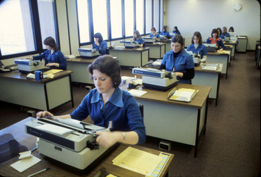
Photograph, Typists at the Board, August, 1977
As the Yarra became unsuitable as a source of water, several attempts were made to find alternative sources for the growing population of Melbourne. It was not until 1891 that the efforts to sewer Melbourne came to fruition with the setting up of the Melbourne Metropolitan Board of Works (MMBW), now known as Melbourne Water. From 1891 until 1992, it was the responsibility of the MMBW to safeguard public health by providing a sewerage system and a safe water supply system. In 1992, The MMBW merged with a number of smaller urban water authorities to form Melbourne Water. As the MMBW employed men to undertake secretarial work within the first few decades of operation, it wasn't until 1912 when the first female 'typiste' was employed. This photograph, showing a group of typists employed by the Board, is historically significant as it represents the kinds of jobs that women were employed in during the 1970s. Colour Photograph melbourne water, mmbw, melbourne metropolitan board of works, typists, women, administration