Showing 1800 items
matching first council
-
 Christ Church Anglican Parish of Warrnambool
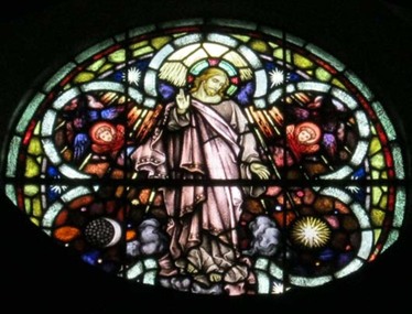
Memorial Window: Elizabeth Edith MACK, "Christ Ascending in Glory"
Elizabeth Edith Mack was born to parents William & Elizabeth (nee Wilmont) Hatton, in approx. 1873 in Moyston, Victoria. She married Frederick David Mack (a wool and skin buyer) in approx. 1903. Frederick Mack was born in 1968 in Warrnambool to parents Joseph and Louisa Mary (nee Despard) Mack. Joseph served as Shire Secretary. The Mack family (including Elizabeth and Frederick) occupied the same sandstone house in the town for more than a century. They had at least 5 children. Elizabeth Edith Mack died in Warrnambool in 1931 aged 58 years. The Circular Memorial Window was erected in her memory by her children. Elizabeth and Frederick's son, Ronald, became The Honorable Sir Ronald (William) Mack, M.L.C. President of the Legislative Council of Victoria. He was knighted in 1967 (the first Warrnambool -Born person to be so honoured) while Minister for Health and regarded the care of the Mentally Ill of prime importance but also the care of the aged. He was given a state funeral after his death in 1968, the service being conducted at Christ Church.The Mack family was a prominent pioneer family in Warrnambool. Her son Ronald William Mack was the first Warrnambool-born person to be knighted.Circular stained glass window above five lancet windows in the west wall of the second nave, depicts 'Christ Ascending in Glory'. The inscription is on a mosaic plaque below the central window.The mosaic tablet below the centrral light refers to this memorial to Elizabeth Mack. "The Above Circular Window/ is erected/ To the Glory of God, in Memory of/ our beloved Mother/ Elizabeth Edith Mack/who departed this life on 23rd December 1931."mack elizabeth edith mack - elizabeth hatton - elizabeth wilmont - moyston victoria - frederick david mack - wool and skin buyer - shire secretary - sir ronald william mack - state funeral - circular window - memorial window - stained glass - christ churc warrnambool -
 Christ Church Anglican Parish of Warrnambool
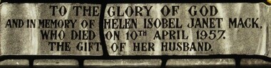
Memorial window: Helen Isobel Janet MACK, "Peace... Goodwill Towards Men"
Helen Isobel Janet Mack was born to parents Gilbert Bailee Nicol and Lizzie (or Lillie) Mary Nicol (nee Jellie) at Woodford, Victoria or Rose Hill Warrong, in approx. 1895. Her mother's parents were James and Sarah Jane Jellie (nee Bower) Her father's parents were Gilbert and Jane Boili Nicol (nee Jelllie) She lived her life here at least until her first marriage. She firstly married a Mr LIndsay and they had two daughters - Helen and Jane. They were later divorced. On 16th February 1935, Helen married Ronald William Mack (a pioneering family of Warrnambool) at the Registry Office in Collins St. Melbourne. They had a son James. It appears Helen lived at 52 Banyan St, including while her husband was absent, until her death. Her husband Ronald William Mack was born in Warrnambool in 1904. He joined the Australian Imperial Forces and was based in the Middle East during some of WW11 and returned to Warrnambool in approx 1943 due to injury. He was involved in the community, and politics and was elected to the Legislative Council in 1955. Janet died on 10th April, 1957, aged 55 years, her funeral leaving Christ Church on April 11th. Her husband had erected in Christ Church, a Memorial Stained Glass window in her memory. Her husband was eventually Knighted (in 1967) while he was Minister for Health of which his main focus was on the mentally ill and the aged. He was then Sir Ronald William Mack. First wife of Sir Ronald William Mack. Stained glass, lancet window, north wall, Hammond Fellowship Centre, Christ Church. Depiction of the Nativity with Mary , Joseph and the infant Jesus"Peace... Goodwill Towards Men"/ To the Glory of God/ and in memory of Helen Isobel Janet Mack,/ who died on 10th April 1957./ The gift of her husband. -
 Christ Church Anglican Parish of Warrnambool
Memorial Plaque: Frederick Stephen STEVENS, CG Roeszler Sc Melbourne; WJ Hickford Warrnambool, Late 19th Century
The bells presented to Christ Church were brought to Melbourne for the 1881 Melbourne Exhibition where they were awarded 1st prize. Frederick Perkins Stevens several years later also provided the three stained glass windows above the main altar within the church as a memorial to his first wife, Jane, FS Stevens' mother.The plaque acknowledges the loss of a son, the provision of the three bells and the status of the donor.Ornately decorated, coloured and inscribed brass plaque within an oak frame. Red and blue colouring within the design elements and lettering.The Three Bells erected / in this Tower were / presented to Christ Church warrnambool by FP Stevens / Member for Villiers & Heytesbury / of the Legislative Council of / Victoria 1852 / In Memory of his younger Son / FS Stevens who died at his Station / Tintinchilla Queensland / 26th May 1880 Aged 30 Yearsfp stevens, fs stevens, german bells, german bells melbourne exhibition 1881 -
 Warrnambool and District Historical Society Inc.
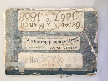
News Sheet, Warrnambool Examiner 1/10/67 - 31/12/67 : 3/1/68 - 31/3/1868, 1867-8
The Warrnambool Examiner was founded by John Wilkinson and Richard Osburne in 1851. After a gap of a couple of years Richard Osburne resumed publication In October 1853 and continued until October 1867. William Fairfax and Henry Laurie then leased the paper (1867 to 1872) before Richard Osburne again became the proprietor from October 1872 to April 1878 and from December 1870 to December 1880 when publication ceased. Richard Osburne was a pioneer settler in Warrnambool, arriving in 1847. He was prominent in community activities in the town and was a most important early historian, publishing his seminal work, ‘The History of Warrnambool’ in 1887, using the Warrnambool Examiner newspapers to assist with this history. Fairfax and Laurie were the proprietors when these papers were printed. William Fairfax was a member of the Fairfax family that were, and still are, associated with the publication of many Australian newspapers and Henry Laurie later became well-known as a Melbourne University Philosophy Professor. These original newspapers are most important because they contain much information on Warrnambool’s early history and are a primary source for historians. These papers are also of importance today as some parts of these papers were not filmed and are not currently available on microfilm. These papers were in a Warrnambool City Council storage area and it is surmised that they have come from the old Warrnambool Museum which no longer exists.These are two sets of original Warrnambool Examiner newspapers (1st October 1867 to 31st December 1867 and 3rd January 1868 to 31st March 1868), bound with cardboard, dark blue binding and string. There are six loose pages in front of the first bound set. These are broadsheets of two pages printed back and front. The papers are heavily marked with red and blue pencil and are marked, ‘private copy, F.& L.’ indicating that they are the copies the proprietors, Henry Laurie and William Fairfax, used to annotate the papers for the next edition. The pages are in good condition with some ragged edges. ‘F & L’ ‘Private copy’ warrnambool examiner, henry laurie, william fairfax, richard osburne -
 Warrnambool and District Historical Society Inc.
News Sheet, Newspaper Warrnambool Examiner, 1870
The Warrnambool Examiner was founded by John Wilkinson and Richard Osburne in 1851. After a gap of a couple of years Richard Osburne resumed publication in October 1853 and continued until 1867. William Fairfax and Henry Laurie then leased the paper (1867 to 1872) before Richard Osburne again became the proprietor from October 1872 to April 1878 and from December 1879 to December 1880 when publication ceased. Richard Osburne was a pioneer settler in Warrnambool, arriving in 1847. He was prominent in community activities in the town and was a most important early historian, publishing his seminal work, ‘The History of Warrnambool’ in 1887, using the Warrnambool Examiner newspapers to assist with this history. Fairfax and Laurie were the proprietors when the papers described herein were printed. William Fairfax was a member of the Fairfax family which was, and still is, associated with the publication of many Australian newspapers. Henry Laurie later became well-known as a Melbourne University Philosophy Professor. These original newspapers are most important because they contain much information on Warrnambool’s early history and are a primary source for historians. These papers are also of importance because some parts of these papers were not filmed and are not currently available on microfilm. These papers were in a Warrnambool City Council storage area and it is surmised that they have come from the old Warrnambool Museum which no longer exists. These are original copies of the Warrnambool Examiner newspapers from 1st April 1870 to 28th June 1870 and from 1st July 1870 to 30th September 1870.The two sets of papers are bound together with plain cardboard, grey binding and glue. The front cover of the first set is missing. The papers are broadsheets of two pages per copy with printing on both sides. The first page of the copy for 1st April is missing. The pages are tattered on the edges. The advertisements and public notices of both sets have been marked by an editor in red and blue pencil. warrnambool examiner, richard osburne, william fairfax, henry laurie -
 Warrnambool and District Historical Society Inc.
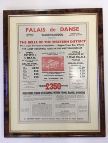
Document - Palais de Dance Warrnambool, 1954
Warrnambool’s first Palais was established in the Hotel Mansions on the corner of Koroit and Kepler Streets and destroyed by fire in 1929. The second Palais was established at the Liberty Theatre in Lava Street. The third Palais was established in the Oddfellows Hall building in Koroit Street in 1939. Dances were held weekly and sometimes more often and attracted musical talent from the Warrnambool district and even from Melbourne with band leaders such as Tommy Davidson and Vin Mills. In 1974 the Warrnambool City Council bought the building and it was used only intermittently for entertainment purposes. Today the building is in private hands and is used for commercial and business purposes. This advertisement is of considerable significance as it comes from the Palais de Danse dance theatre which was important as a social institution in Warrnambool for over 30 years. The advertisement also reminds us of the era (1940s, 50s, 60s) when beauty pageants and Belle of the Ball competitions were popular all over Australia. This is a document in a brown plastic frame with a gold-coloured metal inside edging. The frame has a glass front. The document is a 1954 advertisement for the Palais de Danse dance floor in the Oddfellows Hall in Koroit Street, Warrnambool. The advertisement has black and red printing on a buff-coloured background. The advertisement has an ornamental edge around the printing and a red-coloured photograph of the dance floor. ‘Palais de Danse, Warrnambool, proclaims The Belle of the Western District, The Largest Provincial Competition, Biggest Prizes Ever Offered, The Most Beautiful Girls in the Western District’ etc etcpalais de danse, warrnambool, beauty pageants, warrnambool -
 Warrnambool and District Historical Society Inc.
Map, Plans (5) showing Subdivisions of Warrnambool, 1989
These plans have been drawn by Steve Hester for the Warrnambool City Council to illustrate the allotments in Warrnambool concerned with the subdivisions of 1989. The streets have not been named but there is an indication of the area with the identification of known buildings (eg Hospital) and the plan numbers of each allotment is clearly marked. These numbers corresponded to the plan numbers registered in card files and ledgers in the Warrnambool City Council offices. The scale of the plans was 1 to 5000. These plans are of considerable interest because they show Warrnambool street subdivisions of 1989 in illustrative form. They show how information was collated in the late 1980s before the widespread use of computer digital means to describe and store information.These are five hand-drawn sheets showing plans of sub-divisions in Warrnambool streets in 1989 (Warrnambool City Council material). The plans are multi-coloured (crayons) and show allotments with plan numbers. The first plan has much of the material torn off but the location is known to be in the Russells Creek area. Some of the green tape around the edges is missing. Plans two to five are almost intact and are bound with green tape. Plan Two- Industrial Estate of West Warrnambool; Plan Three – Hospital/Merrivale/ Lake Pertobe areas; Plan Four – North Warrnambool, Wollaston/Brierly areas; Plan Five – Flaxman Street area. ‘Subdivision Plan, Reference Guide, Steve Hester, Oct. 1989’. warrnambool street subdivisions, steve hester, history -
 Warrnambool and District Historical Society Inc.
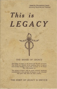
Booklet, This is Legacy, 1947
Legacy had its origins in the aftermath of the first World War. General Sir John Gellibrand in 1923 in Hobart established the Remembrance Club which was to assist returned soldiers. He convinced Stanley Savige a returned soldier who had served with Gellibrand to set up a similar group in Melbourne. The Melbourne group was established at Anzac House shortly after. Initially looking to the needs of returned soldiers, by 1925 they had included the care of deceased soldiers’ widows and children a task which continues to the present day. It is an entirely honorary organization. It lists among its objectives as doing all for the children which the father would have been glad to see done for them. The Warrnambool club was founded in 1947 and this booklet lists the office bearers as Chas Watts, I Buzzard, D B de Beaurepaire, A K Browne R Potter, N K Morris, P H Allen, W J Tolmie, J Paterson, b C Stronach, L G Stevens, T b Patrick, R S Robinson, J O Tait. The Warrnambool region covered from Port Campbell north to Pormborneit, through Darlington and Woorndoo and across to Broadwater and Codrington and Port Fairy in the west. In 1947 they had 200 wards under their care. This booklet has as its centre pages two photographs depicting children and adults and the captions to raise £10000 towards their work and also to build a holiday camp on beach frontage already approved by the Warrnambool City Council.This booklet has historical and social significance as it shows the endeavor of the people of the district to care for those affected by war, in the district and records the names of the first people involved in working with Legacy in Warrnambool .Dark cream coloured soft card cover with brown text. Title is in larger text with the Legacy emblem in the centre of the front cover. The back cover has the poem, Flanders Field and the legacy response. Eight pages which has text and some photographs. A list of Warrnambool office bearers is on the inside back cover. *Printers Geelong. Issued by Warrnambool Legacy. warrnambool, warrnambool legacy warrnambool legacy 1947 -
 Warrnambool and District Historical Society Inc.
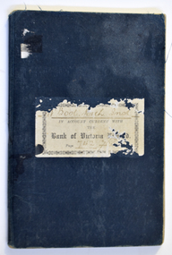
Financial record (Item) - Warrnambool Mechanics Institute & Free Library Bank of Victoria Bank Book, The Bank of Victoria Limited Warrnambool, 1904-1911
The Bank of Victoria was located at 7a Liebig Street, Warrnambool. The building still exists in 2023 as a part of the Quest apartments. The Warrnambool Mechanics' Institute was formed in 1859 and the first reading room opened in 1884. Responsibility for all activities of the Warrnambool Mechanics' Institute activities were formally handed over to the Warrnambool city Council on 27th July 1911. This Bank of Victoria Limited passbook documents credits and debits of the Warrnambool Mechanics' Institute & Free Library from December 1904 until 30th June 1911 just prior to the transfer to the Warrnambool City Council. This passbook is an example of how banking records were kept in the early 20th century. W'Bool. Mech. Inst. in Account with the Bank of Victoria Limited. Page 742 783warrnambool mechanics’ institute library, bank of victoria, warrnambool -
 Warrnambool and District Historical Society Inc.
Book, Victorian Institute of Surveyors Transactions and Proceedings 1919, 1919
This book belonged to John William Crawley, Junior, a member of the Victorian Institute of Surveyors. He was an engineer, architect and surveyor in private practice in Warrnambool and also the engineer for the Shire of Warrnambool from 1895 to 1935. His father, brother and son were also engineers and worked in that capacity or as the Shire Secretary for the Shire of Warrnambool, with the Crawley family members recording a total of 132 years of service to the Shire of Warrnambool which existed from 1863 to 1994. This book is retained as it belonged to John Crawley, the engineer for the Shire of Warrnambool for 40 years. This is a hard cover book with a dark brown cover with gold lettering on the spine. The cover is stained and worn away in places. The book contains 14 articles, reports of the Council for the years 1909 to 1919 and office-bearers for 1919-20. There are several black and white photographs and fold-out maps and plans. The signature on the first page is handwritten in black ink.J Wm Crawley 9/9/19crawley family, warrnambool, shire of warrnambool, history of warrnambool -
 Warrnambool and District Historical Society Inc.
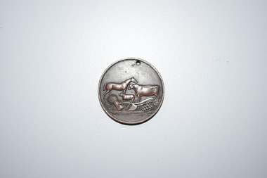
Medal, Stokes and Martin, Rutledge Brothers, 1877
This medal was made by Stokes and Martin. Thomas Stokes established a medal-making business in Melbourne in 1856 and from 1867 to 1893 he had a partner, George Frederick Martin. In 1962 the Stokes business became a public company and operates today in Melbourne. The medal was awarded at the Annual Show of the Villiers and Heytesbury Agricultural Association in 1877. One of the earliest agricultural associations in Victoria, the V.& H.A.A., the forerunner of the Warrnambool Agricultural Society, was established in 1854 and the first Warrnambool Show was held in 1855 at the first Royal Archer Hotel in Koroit Street. The Warrnambool Agricultural Show is still held annually. The medal, first prize for the best horse hay rake, was awarded in 1877 to the brothers, Thomas and William Rutledge, sons of Eliza and William Rutledge. The latter was a pioneer settler who came to the Warrnambool/Port Fairy district as the purchaser of the Special Survey, Farnham Park in 1841. His land stretched from Tower Hill to Dennington. William Rutledge Senior was a pioneer breeder of a Lincoln sheep stud, the owner of a mercantile business in Port Fairy, a member of the Legislative Council of Victoria and the pioneer developer of farming land around Tower Hill. His son Thomas (1846-1918) was a Warrnambool Shire Councillor who farmed in the Farnham Survey, living at Werronggurt . He went to the Geelong area at the end of the 19th century. His brother William (1849-1935) also farmed in the Farnham Survey, living at Farnham Park, He later lived at Airlie in Henna Street, Warrnambool and Sherwood on the Hopkins River and had land in the Otway Ranges. He later went to New Zealand.This medal is of considerable significance because of its age and its association with Thomas and William Rutledge and with the Villiers and Heytesbury Agricultural Association.This is a bronze medal with an image of agricultural implements, agricultural produce and farm animals on one side and etched printing on the other side. There is also printing around the edge of the medal. The medal has a small hole at the top for attaching the medal to a cord. Villiers & Heytesbury Agricultural Association 1st Prize awarded to Rutledge Bro. for Horse Hay Rake Annual Show Warrnambool 10 Oct. 1877 Stokes & Martin Melbourne thomas and william rutledge, farnham special survey, villiers and heytesbury agricultural association, warrnambool agricultural society, history of warrnambool -
Warrnambool and District Historical Society Inc.
Publication, Collett and Bain, Heytesbury Forest School, c.1971
This booklet, by Rosamund Duruz, gives the history of the schools in the Heytesbury Forest area. The Heytesbury Shire Council was established in 1863 and the first schools in the area opened in the 1870s. Most of them were closed when Timboon Consolidated School (later Timboon High School) opened in 1948. The Heytesbury Forest was largely deforested by the Bailey Closer Settlement Scheme of the 1930s and later the establishment of more farming properties in the 1950s. This booklet is of interest as a comprehensive history of the schools in the Heytesbury Forest area pre 1970. It will be useful for researchers. This is a soft-cover booklet of 63 pages. The cover is a cream colour with brown images of trees and a school on the front cover. The booklet includes a map, a sketch and several black and white photographs. The booklet is bound with metal staples.schools in heytesbury forest, victoria, rosamund duruz, historian, history of warrnambool -
 Port of Echuca
Photograph - Black and white photograph, Late 1970s
Relates to a series of 5 photos:P000094-P000098 of the front of the Bridge Hotel on the corner of Murray esplanade and Hopwood gardens. These photos, taken about 1976, were before the Port Restoration Scheme renovated the hotel. The Bridge Hotel was built by Henry Hopwood in 1858. This and the Bond Store were Echuca's first 2 brick buildings. Named from Hopwood's nearby pontoon bridge. The building was bought be The Council in 1970. Restored and reopened in 1975.The Bridge Hotel is an important part of Echuca's settlement and development. It was originally built by Henry Hopwood, the European founder of Echuca, in 1859. Hopwood built the hotel to provide accommodation to people using his punts across the Campaspe and Murray rivers that area central to the landscape of the Port. The hotel was situated on the land between both rivers and punts and provided for a variety of levels of accommodation from grand rooms to very basic rooms. At the time of the photos the hotel was 120 years old and became an important part of the Port of Echuca tourism. Black and white photograph of the Bridge Hotel , showing western wing before restoration.Stamped on the reverse "Gazemore Studio, D. G. Gay, 18 Frances Street Echuca 3625.bridge hotel, echcua, port restoration scheme, bridge hotel restoration, echuca -
 Eltham District Historical Society Inc
Photograph, Fay Bridge, Moor-rul Viewing Platform, Garden Hill, Kangaroo Ground, n.d
OPENING OF THE VIEWING PLATFORM AT KANGAROO GROUND Nillumbik Council has advised that the viewing platform at Kangaroo Ground 27km NE of Melbourne is to be opened to the public on Wednesday, March 26th 2008 (Melway 271 , G10). The function of the platform is to provide shelter adjacent to the War Memorial Tower whilst allowing all people to enjoy the stunning panoramic views. From the platform you. can see the Dandenongs, the city of Melbourne, the You Yangs, Mount Macedon, the Kinglake Ranges and the Mt Baw-Baw Ranges where the Yarra River starts. This landscape covers all the ancestral lands of the Wurundjeri and some of the wider Kulin nation land. The platform has been given the name Moor-rut, a name which described the fertile soils of the Kangaroo Ground area in contrast to the poorer (Silurian) country of its surrounds, which the Wurundjeri knew as 'Nillumbik' or less rich country. The full 360 degree view can be seen from the adjacent Tower of Remembrance which has 53 stairs. The viewing platform however can be accessed by wheelchair. Inside the viewing platform there are eight double sided interpretive panels giving the history and information regarding this special area. The viewing platform's interpretive panels set out the Aboriginal and European history of the area and also the geology and the local flora and fauna, so that the casual visitor comes away understanding more about this significant part of Victoria. The concept of the viewing platform is part of the refurbishment project for the Kangaroo Ground War Memorial Park which has taken place since 1997 with the active approval and financial assistance of the Nillumbik Shire Council. This project has been guided by an Advisory Committee with volunteer community representatives from the local Historical Societies, the Country Fire Authority, the Returned Services League and the Wurundjeri people. Other allied groups such as the Nillumbik Reconciliation Group have been called upon for their expertise. The initial idea for the viewing platform came from Dean Stewart when he was the caretaker while living at the park. He discussed this idea with local author Mick Woiwod and Harry Gilham of Eltham District Historical Society when they were planning the refurbishment of the War Memorial Park in 1996. When the committee was formalised by the Nillumbik Council in 1997, Nicholas Pelling, representing the CFA and RSL, joined the group. Dennis Ward, local architect, then volunteered to develop the concept plan for the refurbishment of the park and later drew up the plans for the viewing platform. The Kangaroo Ground War Memorial Park and its Tower of Remembrance is located on one of the highest locations in the Yarra Valley. The Tower of Remembrance is a unique war memorial constructed from local stone standing 14 metres high. It was built in the style of a Scottish watchtower reflecting the strong Scottish influence of the first European settlers of the district from the 1840s onward. The park was opened in 1921 and the Tower of Remembrance was dedicated in 1926 recognising the local people who served in the First World War. Those who served in the Second World War were recognised by plaques dedicated in 1951 and more recently those who served in Korea, Borneo, Malaya and Vietnam by plaques unveiled in 2001. Harry Gilham, Advisory Committee Convenor - Eltham District Historical Society Newsletter N0 179 March 2008fay bridge collection, garden hill, kangaroo ground, memorial park, moor-rul viewing platform -
![Book - Map, Land Conservation Council, Melbourne Study Area Report, [December 1973]](/media/collectors/4f729f7b97f83e03086018a5/items/6469bc241d76dd4b008a829f/item-media/646b0013d841f8920fa4323c/item-fit-380x285.jpg) Eltham District Historical Society Inc
Eltham District Historical Society IncBook - Map, Land Conservation Council, Melbourne Study Area Report, [December 1973]
The Melbourne Study Report is a series of volumes describing the physical nature of the land and its environment, examines the likely forms of land use, and assesses the hazards associated with these uses. This is Volume 2 (coloured maps). The first page featues a black and white map described as "Shire of Diamond Valley" with public land marked in yellow. Followed by eight large fold out maps. Melbourne Study Area Public land and descriptive blocks, Population description, Geology, Physiography, topography and rainfall, vegetation and water supply. The Land Conservation Act 1970 established the Land Conservation Council whose functions is to "carry out investigations and make recommendations to the Minister with respect to the use of public land in order to provide for the balanced use of land in Victoria. This report sets out to describe and assess the natural resources of the public lands in the Melbourne area and provides a factual basis on which members of the community may base submissions to the [Land Conservation] Council of Victoria.A collection of eight large fold out coloured maps published in a bound book formnon-fictionThe Melbourne Study Report is a series of volumes describing the physical nature of the land and its environment, examines the likely forms of land use, and assesses the hazards associated with these uses. This is Volume 2 (coloured maps). The first page featues a black and white map described as "Shire of Diamond Valley" with public land marked in yellow. Followed by eight large fold out maps. Melbourne Study Area Public land and descriptive blocks, Population description, Geology, Physiography, topography and rainfall, vegetation and water supply. The Land Conservation Act 1970 established the Land Conservation Council whose functions is to "carry out investigations and make recommendations to the Minister with respect to the use of public land in order to provide for the balanced use of land in Victoria. This report sets out to describe and assess the natural resources of the public lands in the Melbourne area and provides a factual basis on which members of the community may base submissions to the [Land Conservation] Council of Victoria. maps, shire of diamond valley, population, geology, topography, rainfall, vegetation, water supply, land use, public lands -
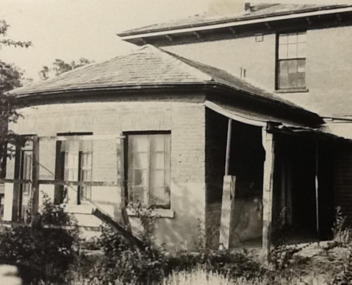
 Eltham District Historical Society Inc
Document - News Clipping, Jodie Guest, Residents have their say on former shire offices, Diamond Valley News, October 16, p9, 1996
Nillumbik Commissioners used 'reserve power's to permit a controversial Shell service station and Hungry Jackls restaurant development at the former Eltham Shire Office site at 895 Main Road. More than 200 people attended the Council meeting in the public gallery and protested at the decision. 32 personal submissions were made to Council's Planning Special Committee meeting whose members vioted 3-2 against the development. The Committee consisted of the three Nillumbik Commissioners and three community members (Jim Connor, Bronwyn South and Janet Mattiske). Chief Commissioner Don Cordell, a former Shell employee excused himself from voting and the three communbity memebrs voted against the submission. The other two commissioners, Vin Heffernan and Kevin Abbott voted against it. They then immediately closed the meeting and opened a Council meeting lasting just seconds to use special reserve powers to overturn the decision. Community residents who made submissions included Russell Yeomans speaking on behalf of the Eltham Gateway Action Group and Eltham District Historical Society, Des Ryan on belaf of Eltham Senior Citizens, Angela Newhouse, others on behalf of Our Lady Help of Christians Primary School and Judge Book Village, Tom Munro, Ian Jennings, Margartet Ball a fifth generation descendant of the Shillinglaw family, one of the early settlers of the area and owner of the land that was sold to Council, Frank Burgoyne who said "there will be a lot of creaking and rumbling in the cemetery if this goes through. So many old people who have done so much for Eltham are buried up there and it is up to us to pass on what they left to the younger generation. Eltham is a beautiful spot; why louse it up?" A second article "Anger over reserve power" by Laeta Antonysen provides commentary from the three Planning Special Committee community members, former Eltham Shire Councillor Jim Connor, Bronwyn South and Janet Mattiske about the process that took place and the first time use of the spoecial reserve power to overturn the decision of the committee. Barry Rochford, Nillumbiuk CEO defends the use of the power.The demolition of the former Shire of Eltham offices and proposed sale and development driven by the Commissioners for Nillumbik Shire Council brought the community together in substantial protest at the infrigement of ratepayers democratic say in local government and ciommunity assets combined with protests about inappropraite development of Eltham's Gateway. This issue led to the formation of the Eltham Community Action Group which still operates strongly today (2023) on behalf of the community to ensure appropriate development within the community.895 main road, commissioners, dallas price homes, development application, eltham hub, hungry jacks, nillumbik shire council, re-zoning, shell service station, town planning, eltham gateway, eltham gateway action group, eltham shire offices, shillinglaw farm, shillinglaw trees, jim connor collection, dallas howgate, nillumbik planning special committee, jim connor, bronwyn south, janet mattiske, don cordell, vin heffernan, kevin abbott, russell yeomans, eltham district historical society, eltham senior citizens, des ryan, our lady help of christians primary school, judge book village, angela newhouse, tom munro, ian jennings, margaret ball, shillinglaw cottage, frank burgoyne, andrew biasci, barry rochford -
Eltham District Historical Society Inc
Document - Folder, Masefield, Bert and Ethel
Bert Masefield's parents came from Lancashire to Surrey Hills, his education ending because of the depression when he went to work at an orchard at Hastings. When his father list his job as a cabinet maker, he bought an orchard at Cottlesbridge and Bert joined them, ploughing with a horse. He met and married Ethel Smith who had grown u at Panton Hill; her great grandparents Sarah and Samuel Smith came from Lancashire where they had a cotton mill and iron foundry, settling at Smith Gully between Panton Hill and St Andrews. Their son Edwin married Louisa Purcell whose parents owned the Caledonie Hotel at Smiths Gully; they had 12 children and settled on a property in Cherrytree Road. Son Edwin left Panton Hill school aged 11 in 1885 and worked with his father and uncle fencing the family property. Edwin had nine children, Ethel being the seventh. Aged 14, she gained a scholarship to Stotts Business College. Berth and Ethel, when they married, bough a property in Cherrytree Road. In 1941 Bert, a ham radio enthusiast, joined the RAAF as a radio mechanic, serving in Townsville and New Guinea until 1945. Over time, they subdivided their property. Bert worked for ten years as property officer for Eltham Shire Council; his work included coverting Three Chain Road (or Gumtree Road) into a huge firebreak. Now retired, Bert spends time speaking with radio operators around the world and the couple are involved with sports including the Montmorency Bowling Club; they were foundation members of the Hurstbridge Bowling Club. Marjorie North (nee Cooper) was 14 when her family moved from the city to Montmorency when the railway station was first built in 1923. Marjorie described her memories of Montmorency at that time. She and sister Connie were keen tennis players, playing at Greensborough. By 1927, they had arranged, though shire engineer Ben Johnson, to rent land from the Council for 10 pounds a year; Mr Paragreen levelled the land. The club held a dance every three weeks in a school room with piano for music. She won the singles, doubles and mixed doubles championships in 1929 at the first championship. Contents Newspaper article: "Round the world on radio waves," Diamond Valley News, 30 September 1986, outlines Bert and Ethel Masefield's lives. Newspaper article: "Stalwart recalls the early days," Diamond Valley News, 30 September 1986, outlines Bert and Ethel Masefield's lives.Newspaper clippings, A4 photocopies, etcbert masefield, elthel masefield, ethel smith, cherrytree road panton hill, samuel smith, sarah smith, smith gully victoria, caledonie hotel smiths gully, stotts business college, montmorency bowling club, hurstbridge bowling club, eltham shire council, edwin smith, louisa purcell, parragreen of para road, ben johnson, montmorency tennis club -
 Eltham District Historical Society Inc
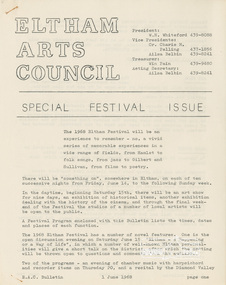
Document - Folder, Eltham Arts Festival, 1968
Material relating to the first Eltham Arts Festival organised by the Eltham Arts Council. It was held Friday June 14 to Sunday June 24, 1968. Events included an Art Show, Jazz Night, Musical Workshop, Photographic exhibition, String Quartette performance at Montsalvat, A night with the Poets, Evening of Chamber Music, Historical Exhibition (organised by the Shire of Eltham Historical Society), Choral Recital, Gilbert & Sullivan performance at Eltham High School, Film festival, Fesitval luncheon and Open discussion eventing with the theme: Eltham: A Happening or a Way of Life".Bulletin: Eltham Arts Council Special Fesitval Issue, 1 June 1968 Poster: Eltham Festival (calandar of events) Poster: Eltham Festival Jazz Night Program: History of Jazz Program: 1968 Eltham Art Show (includes complete list of paintings, sculpture, craft and pottery and their creators)whiteford, charis pelling, ailsa belbin, win pain, eltham arts council, eltham art show, eltham art awards, jazz festival -
 Eltham District Historical Society Inc
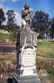
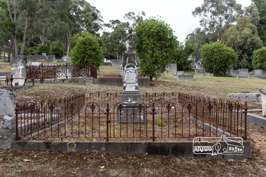
Negative - Photograph, Harry Gilham, Grave of Alfred and Margaret Armstrong, Eltham Cemetery, Victoria, Sep 2009
Alfred Patrick Armstrong was born in England in 1825 and was employed under the renowned Isambard Kingdom Brunel as a civil engineer during the construction of the Great Western Railway and the South Wales Railway. He came to Melbourne in 1852 and purchased property in Eltham. He became a mining surveyor and was Inspector of Mines and the Mining Registrar for the St Andrews Division of the Castlemaine Mining District. In 1855, he chaired a meeting calling for a bridge to be erected across the Yarra River between Eltham and Temple Stow. He was registered as an innkeeper in 1858, was a recognised collector of the £110 raised for the building of the first building of State School No. 209 (Eltham Primary) and was a Trustee for the Church of England site on the Eltham Cemetery Trust in 1860. He was elected to the Eltham District Road Board (forerunner of Eltham Shire Council) from 1867 to 1871 and then served as an Eltham Shire Councillor from 1871 to 1878 (including Shire President in 1873). Margaret Armstrong to whom he was married in 1854 at St Pauls Church, Melbourne, died on the 27th March 1887. Alfred died in 1893, having been in ill health for some time, and is buried in Eltham Cemetery with his wife Margaret. The monument features a tall pillar capped with a draped urn: a symbol of death. In Loving Memory of Alfred Armstrong Died May 27tth 1893 Aged 68 years Also of his wife Margaret Died March 27th 1887 Aged 63 years This burial site is of special interest as the monument has the tallest pillar-a vase-a draped cloth top (unfulfilled life) and additional panels of names around the sides and the base, which include: Ada Gertrude Armstrong, beloved daughter of Alfred & Margaret Armstrong, died May 30th 1878, aged 21 years Mary Armstrong, beloved mother to Alfred Armstrong, died April 10th, 1886 aged 82 years Arthur Vivian Harrison, died 4th Nov. 1899, aged 8 years Arthur Reynolds Stockwood Armstrong, son of Alfred Armstrong, died 4th Nov. 1908, aged 43 years Laura Augusta Harrison nee Armstrong, died 26th July 1921, aged 64 yearsRoll of 35mm colour negative film, 6 stripsKodak GC 400-9eltham cemetery, gravestones, alfred armstrong, margaret armstrong, ada gertrude armstrong, arthur reynolds stockwood armstrong, arthur vivian harrison, laura augusta harrison (nee armstrong), mary armstrong -
 Eltham District Historical Society Inc
Photograph, Peter Pidgeon, Grave of Alfred and Margaret Armstrong, Eltham Cemetery, Victoria, 5 April 2021
Alfred Patrick Armstrong was born in England in 1825 and was employed under the renowned Isambard Kingdom Brunel as a civil engineer during the construction of the Great Western Railway and the South Wales Railway. He came to Melbourne in 1852 and purchased property in Eltham. He became a mining surveyor and was Inspector of Mines and the Mining Registrar for the St Andrews Division of the Castlemaine Mining District. In 1855, he chaired a meeting calling for a bridge to be erected across the Yarra River between Eltham and Temple Stow. He was registered as an innkeeper in 1858, was a recognised collector of the £110 raised for the building of the first building of State School No. 209 (Eltham Primary) and was a Trustee for the Church of England site on the Eltham Cemetery Trust in 1860. He was elected to the Eltham District Road Board (forerunner of Eltham Shire Council) from 1867 to 1871 and then served as an Eltham Shire Councillor from 1871 to 1878 (including Shire President in 1873). Margaret Armstrong to whom he was married in 1854 at St Pauls Church, Melbourne, died on the 27th March 1887. Alfred died in 1893, having been in ill health for some time, and is buried in Eltham Cemetery with his wife Margaret. The monument features a tall pillar capped with a draped urn: a symbol of death. In Loving Memory of Alfred Armstrong Died May 27tth 1893 Aged 68 years Also of his wife Margaret Died March 27th 1887 Aged 63 years This burial site is of special interest as the monument has the tallest pillar-a vase-a draped cloth top (unfulfilled life) and additional panels of names around the sides and the base, which include: Ada Gertrude Armstrong, beloved daughter of Alfred & Margaret Armstrong, died May 30th 1878, aged 21 years Mary Armstrong, beloved mother to Alfred Armstrong, died April 10th, 1886 aged 82 years Arthur Vivian Harrison, died 4th Nov. 1899, aged 8 years Arthur Reynolds Stockwood Armstrong, son of Alfred Armstrong, died 4th Nov. 1908, aged 43 years Laura Augusta Harrison nee Armstrong, died 26th July 1921, aged 64 yearsBorn Digitaleltham cemetery, gravestones, ada gertrude armstrong, alfred armstrong, arthur reynolds stockwood armstrong, arthur vivian harrison, laura augusta harrison (nee armstrong), margaret armstrong, mary armstrong -
 Eltham District Historical Society Inc
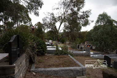
Photograph, Peter Pidgeon, Memorial to Alistair Knox, Eltham Cemetery, Victoria, 5 April 2021
Alistair Knox was an architect and builder who came to Eltham in 1948. Influenced by Frank Lloyd Wright and Walter Burley Griffin, he sought to create buildings that would blend into the landscape, enhanced by the planting of indigenous flora. The post-war shortage of building materials made traditional construction expensive. Adobe (mudbrick) provided a cheap and plentiful alternative, and one which would be aesthetically pleasing. Mud-brick manufacture was a problem at first. Sonia Skipper had been experimenting with Eltham clays for years to find the best mix for making bricks and render. Alistair employed her as building foreman on several of his sites. By the 1980s, he had brought mud-brick and earth building into the Australian mainstream, and a Knox-designed house had become highly desirable. Sonia said that he would craft a bespoke earthen house to fit with his client's lifestyle. He was drawn to the environmental movement, publishing three books on housing and the environment, and speaking on radio. He also served on the Eltham Shire Council 1971-1975, was Shire President 1974 and was instrumental in re-establishing the Eltham Community Festival in 1975. Alistair died in 1986 and is buried in a small garden setting at Eltham Cemetery.Born Digitaleltham cemetery, gravestones, heritage excursion, alistair knox -
 Eltham District Historical Society Inc
Photograph, Peter Pidgeon, Grave of Alistair Samuel Knox, Eltham Cemetery, Victoria, 5 April 2021
Alistair Knox was an architect and builder who came to Eltham in 1948. Influenced by Frank Lloyd Wright and Walter Burley Griffin, he sought to create buildings that would blend into the landscape, enhanced by the planting of indigenous flora. The post-war shortage of building materials made traditional construction expensive. Adobe (mudbrick) provided a cheap and plentiful alternative, and one which would be aesthetically pleasing. Mud-brick manufacture was a problem at first. Sonia Skipper had been experimenting with Eltham clays for years to find the best mix for making bricks and render. Alistair employed her as building foreman on several of his sites. By the 1980s, he had brought mud-brick and earth building into the Australian mainstream, and a Knox-designed house had become highly desirable. Sonia said that he would craft a bespoke earthen house to fit with his client's lifestyle. He was drawn to the environmental movement, publishing three books on housing and the environment, and speaking on radio. He also served on the Eltham Shire Council 1971-1975, was Shire President 1974 and was instrumental in re-establishing the Eltham Community Festival in 1975. Alistair died in 1986 and is buried in a small garden setting at Eltham Cemetery.Born Digitaleltham cemetery, gravestones, heritage excursion, alistair samuel knox -
 Eltham District Historical Society Inc
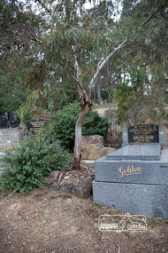
Photograph, Peter Pidgeon, Grave of Charlotte Amelia Taylor, Lillian Jane Taylor and Robert David Taylor, Eltham Cemetery, 5 April 2021
Robert David Taylor was a farmer who lived in Eltham all his life and died in 1934 at the age of 76. Mr and Mrs Bowman lived in York Street; Taylor was their neighbour. In 1933 he subdivided his land, the plan showing a proposed Grey Street flanked by residential blocks for sale. Mrs Bowman bought one: her family would be able to walk through it and along Grey Street to Henry Street, thus providing quicker access to the railway station. But Taylor retained ownership of Grey Street itself. He fenced it off at each end and charged the Bowmans with trespass when they used it. The matter went to Court. The ruling was that Mrs Bowman could use Grey Street, as she owned land in it, but her husband could not. (Taylor also accused the Bowmans of having broken the fences, but could not prove it.) Taylor had wanted to subdivide his land in 1914. Plans were submitted to Council and were approved, but the subdivision did not proceed. In 1919, Taylor doctored the plans to make it appear that a totally different subdivisional arrangement had been approved. The Titles Office immediately detected fraud, and the Crown charged Taylor with forgery and counterfeiting. But charges were later dropped (reason not recorded). He was an Eltham Shire Councillor between 1911 and 1920. In 1920, Council charged him with illegally felling 91 eucalyptus trees in Eltham Park (60% of them in a healthy condition), presumably to be sold as firewood. He was imprisoned pending trial. Taylor claimed that he had acquired from another man the right to remove timber and sued the Council for wrongful prosecution. The case eventually went to the State Full Court, with judgement given in favour of Council, on the grounds that any right acquired by Taylor covered only the removal of logs and refuse, not sound green timber. And his position as Councillor precluded him from acquiring the right anyway. Robert David Taylor was also a Trustee of the Wesleyan Church owned land at Lot 20 Henry Street, originally purchased in January 1855 for a chapel and from which David and Catherine Clark first ran their private school, the forerunner of the Eltham Primary School. The land was sold in November 1901 to the Hope of Eltham Tent No. 195 Victoria District Independent Order of Rechabites, for which his brother William John Taylor was a Trustee and became the home of the Eltham Rechabite Hall. In December 1921 it was again sold, this time to the community for use as the Eltham Public Hall, Robert David Taylor being a member of the Committee.Born Digitaleltham cemetery, gravestones, charlotte amelia taylor, eltham district historical society, heritage excursion, lillian jane taylor, richard pinn, robert david taylor -
 Eltham District Historical Society Inc
Photograph, Liz Pidgeon, Public Records Office Victoria (PROV) visit to Eltham Justice Precinct, 20 Apr 2018
The original Shire of Eltham was founded in 1871. Prior to its founding, the district was managed by the Eltham District Road Board, which was established in 1856. The initial rate assessment commenced in 1857 for the year ending October 14, 1858. The honour of being recorded with the first assessment went to a farm of 110 cultivated acres at Lower Plenty, owned by John Porter and occupied by Albert Baines. It was assessed at 6d/acre providing for a rate income of £2 15s. In July 2017, officers at Nillumbik Shire Council discovered some early Eltham Road District Assessment books and donated them to the Eltham District Historical Society. The seven volumes were the district’s first six years of rate assessments. This was a unique and significant record of early settlers in the pre-Shire of Eltham. They immediately became one of the oldest and most valuable items in our collection. An article on page 5 in the Eltham and Whittlesea Shires Advertiser, Friday, 21 November, 1941 titled: ‘District’s Early History‘ states: “The first rate book which is still in existence at the Shire Office is for the year ending October 14, 1858 and is probably the best record possible to indicate the development of the district. At the time properties were rated as follows: Cultivated land. 6d. per acre; pasture land, 1d. per acre: estimated annual value of buildings, etc., 6d in the (pound). The total amount of rate recorded for the year was £153/14/8. Properties were described as being situated at Lower Plenty, Yarra Yarra, Eltham, Lower Eltham, Kangaroo Ground, Yarra Flats, Diamond Creek and the Yarra.” Given the precious nature of this collection, priority was given to digitise the rate books and place them in suitable archival storage to minimise further handling. Subsequent discussion amongst our Collections team arrived at the conclusion that the most appropriate home for this valuable record was the Public Record Office Victoria (PROV), the archive of the State Government of Victoria and who are charged with archiving and caring for all Government related records. An approach was made to PROV who confirmed these records would complete their collection of rate assessment books for Eltham. At a small ceremony held Friday, April 20 at the Local History Centre, Eltham, members of the Society and our Collections team, along with Ms. Vicki Ward, MP for Eltham, presented the seven volumes for 1858-1863 along with the complete set of digital files to Mr. David Taylor, Community Archives Manager and Mr. Charlie Farrugia, Senior Collection Advisor, Public Record Office Victoria.Born Digitalassessment ledger, donation, eltham courthouse, eltham road district, local history centre, public records office victoria (prov), rate books, eltham district road board -
 Eltham District Historical Society Inc
Document - Series Listing, Fraser Faithfull et al, The Shire of Eltham Memorabilia Collection, 2000
The collection has been catalogued into a number of Series. The main series are Series 1: Main Photographic Series; Series 2: Main Transparency Series; and Series 3: Brochures and Published materials. Every Item in each of these major Series has been individually catalogued on a spreadsheet, one spreadsheet per Series. A further 70 Series have been created to catalogue smaller, discrete collections of photographs and negatives and other memorabilia including registers, published materials and objects. The completion of its transfer to the Society was noted in Newsletter No. 159 November 2004. Generally memorabilia items classified as part of Council 's art collection and negatives of historical photographs have been retained by the Council. The items now stored at our Local History Centre are quite diverse. They include many photographs of Council activities, Councillors and Council staff. There are Council brochures, calendars and other publications. All of these items are catalogued and stored in quality archival boxes. Also included is a large collection of old Council registers such as letter books, contract registers, cash books, etc. Many of these are large leather bound volumes, more of interest for their appearance than for their content. The first meeting of the Memorabilia Reference Group was held December 5, 1996. The aim of the group was to facilitate all actions required for the safekeeping of the Shire of Eltham memorabilia. The members of the group were Harry Gilham President of the Eltham District Historical Society (EDHS), Russell Yeoman EDHS Secretary and Chris Marks Curator of Collections at NSC.shire of eltham archives, series listing, memorabilia reference group -
 Eltham District Historical Society Inc
Audio - Audio Recording, AGM and Jim Connor; Eltham Courthouse Restoration, 24 Nov 2021
Details of the Eltham Courtthouse restoiration undertaken by Nillumbik Shire Council in 2021. This AGM and meeting was held online via Zoom, EDHS' first online meeting as a result of the COVID-19 pandemic. The meeting was recorded and both audio only and MP4 files were saved.1:03:06 duration Digital M4A file; 57.4 MB, Digital MP4 file; 610.6 MBaudio recording, eltham, eltham district historical society, meeting, society meeting, eltham courthouse, nillumbik shire council, agm, jim connor, video recording -
 Eltham District Historical Society Inc
Photograph - Digital Photograph, Marguerite Marshall, Avenue of Honour, Main Road, Eltham, 20 April 2008
The suggestion of an Avenue of Honour may have been originally put forward by Lady Irvine who was a member of the Welcome Home Committee. The Avenue of Honour was established to memorialise all those from Eltham who enlisted (some of whom were still fighting overseas at the time), similarly as the Shire of Eltham (Soldiers) Memorial Park was in tribute to all from the Shire who enlisted. The twenty-seven names of those killed from Eltham were engraved on the Eltham War Memorial Obelisk unveiled in 1919 at the corner of Main Road and Bridge Street. From an article in the Heidelberg News and Greensborough, Eltham and Diamond Creek Chronicle, September 22, 1917, p. 2, it was reported: Some few weeks ago a public meeting was held in the Eltham Rechabite Hall for the purpose of forming a committee to make necessary arrangements for the return of our brave lads from the front, with the result that the following officers were elected, viz., Sir William Irvine. president; Cr. R. D. Taylor, vice-president; Rev. T. W. Sapsford, secretary; Mr R. E. Gilsenan, treasurer; with a very strong committee of local residents. Lady Irvine then suggested that it would be nice to plant an Avenue of Honor, which was carried out in a very cheerful and spirited manner on Saturday afternoon. Cr Taylor and Mr R. E. Gilsenan occupied themselves during the fore-forenoon in getting the lining-out and other preliminaries ready, but shortly after one o'clock the willing workers could be seen wending their way towards the township, with picks, shovels. &c., on their shoulders, and in a very short time the gang at work was in appearance a very lively and pretty sight, the only thing that was missing was the camera, to have had a few snapshots taken. A little after 3 o'clock Sir William and Lady Irvine, and Mr W. Gray and family, arrived by motor. Cr Taylor then explained that their object in gathering together so hurriedly to plant the avenue was on account of the lateness of the season, and being offered 100 trees, free of charge, by Cr. Wm. G. Gray; of Allwood Nursery, Hurst's Bridge (for which the committee are deeply grateful to him and the public highly appreciate his generous offer). Sir Wm. Irvine then spoke at some length on the ravages of this cruel war, and the good that must result therefrom in bringing all closer together; he also referred to our brave lads who were fighting for us, and thought it was for those at home to show their appreciation by planting the Avenue of Honor. Lady Irvine thou proceeded to plant the first tree, which was an English oak: Sir William following by planting a Spanish chestnut; and Mrs W. G. Gray a sycamore. After that the gathering refired to the entrance of Mr R. E. Gilsenan's green paddock to partake of refreshments, which the ladies had kindly provided for the willing band of workers. Work was again taken to in earnest, and the planting finished, all being satisfied that they had done good work. At the Eltham Shire Council’s monthly meeting held May 6, 1918, Cr. Gray promised to give Council £20 to £25 worth of trees if the Council would plant and guard them. His desire was that a tree be planted in the name of every soldier lad who has gone to the front. Each tree was later adorned with a brass plaque with the name of a soldier and a wooden tree guard placed around them. Over the years many trees died, and following roadworks were replanted on a new alignment. Nillumbik Shire Council is continuing this process of replanting trees in a new alignment to move them away from overhead power lines and to clear the VicRoads reserve. Covered under Heritage Overlay, Nillumbik Planning Scheme. Published: Nillumbik Now and Then / Marguerite Marshall 2008; photographs Alan King with Marguerite Marshall.; p119This collection of almost 130 photos about places and people within the Shire of Nillumbik, an urban and rural municipality in Melbourne's north, contributes to an understanding of the history of the Shire. Published in 2008 immediately prior to the Black Saturday bushfires of February 7, 2009, it documents sites that were impacted, and in some cases destroyed by the fires. It includes photographs taken especially for the publication, creating a unique time capsule representing the Shire in the early 21st century. It remains the most recent comprehenesive publication devoted to the Shire's history connecting local residents to the past. nillumbik now and then (marshall-king) collection, avenue of honour, main road, eltham -
 Eltham District Historical Society Inc
Photograph - Digital Photograph, Alan King, Shire of Eltham War Memorial, Kangaroo Ground, 28 January 2008
The Eltham Shire War Memorial, a tower of remembrance, was built with public donations to commemorate the memory of the fallen soldiers from the shire who enlisted in the 1914-1918 war. The tower is reminiscent of the peel-towers or watchtowers that lined the English-Scottish border from the mid 14th century to around 1600 and is constructed from locally quarried stone. This uncommon and picturesque war memorial, which affords an excellent view of the surrounding district was unveiled by His Excellency the Governor-General (Lord Stonehaven) on November 11, 1926. In July 1922 a deputation of returned soldiers from Panton Hill, presumably the Panton Hill branch of the Returned Sailors and Soldiers Imperial League of Australia (RSSILA), proposed to Eltham Shire Council that the monument should be a cairn of local stone “sufficiently high to form a prominent and conspicuous landmark, and crowned with some suitable device”. Eltham Shire Councillor and President of the Panton Hill branch of the RSSILA, Basil Hall, was credited with being the first to suggest a tower, and with organising a Memorial Park committee to raise funds for the monument in the Memorial Park. A meeting for those interested in the establishing a War Memorial monument in the park was held in January 1924 and the Eltham Shire War Memorial League was formed for this purpose. It appears that the broad and rounded cairn that had been recently built was considered by the League a temporary affair, and not the substantial cairn-as-monument, sufficiently high to form the conspicuous landmark, which had been envisaged by the Panton Hill RSSILA. A design competition was held for the monument. The chairman of the League, Councillor Basil Hall, suggested that the site of the memorial in Kangaroo Ground would lend itself to something rugged, instead of polished stone. By April 1924 thirty designs for a memorial had been received from which three designs were selected and of those, the design by the shire engineer Mr McCormack, for a 70ft tower suitable for construction in rough stone, was chosen. Artist Harold Herbert suggested that a peel tower-like design reminiscent of those along the English-Scottish border would be fitting for the site. Herbert drew up a rough sketch that was approved of, and later, Melbourne architect Percy Meldrum volunteered to draw up the design from sketch to architectural drawings. By January 1925 the Soldiers’ Memorial League had adopted Meldrum’s design for a 50ft high tower. Meldrum had also offered his design and supervision of construction free of charge. The Shire provided the stone to the builders, which was a gift quarried from land owned at Kangaroo Ground by Dr Ethel and Professor William Osborne The Shire of Eltham War Memorial, a tower of remembrance, and honour board were unveiled on November 11, 1926, by the Governor General Lord Stonehaven. At this stage a temporary honour roll was painted on the panels on either side of the tower entrance. In September 1930 bronze plates were added above the portal with the names of men who fell in the 1914-18 war. On November 16, 1951, the Governor of Victoria, Sir Dallas Brooks re-dedicated the war memorial tower and unveiled the names of men who gave their lives in the 1939-45 war. Two additional bronze plaques which recognise service in the armed conflicts of Korea, Borneo, Malaya, and Vietnam were unveiled November 11, 2001, by the Governor of Victoria, John Landy, A.C., M.B.E. The tower was first used for fire spotting activities following the Black Friday bushfire in January 1939 in response to a request from Mr R.D. Ness, secretary of the Kangaroo Ground bush fire brigade, who asked Council that the tower be used as an observation tower for detecting bush fires, and asked Council to arrange a telephone to be installed. It was suggested that if the Shire were to appoint a caretaker for the Memorial Park, his duties could also include raising the alarm in the event of a fire. Later in 1939 Council applied for a radio transmitter, which the Forestry Commission planned to install at vantage places throughout the state. The first dedicated fire spotter appointed from December1948, was Mr Smith of Warrandyte. A prefabricated glazed cabin was installed in 1974, which involved the removal of the original stone structure around the rooftop exit door. A new fire spotting cabin, which included the latest technology, was installed soon after the 2009 Black Saturday fires and is manned by CFA personnel on high fire danger days. Covered under Heritage Overlay, Nillumbik Planning Scheme. Published: Nillumbik Now and Then / Marguerite Marshall 2008; photographs Alan King with Marguerite Marshall.; p123This collection of almost 130 photos about places and people within the Shire of Nillumbik, an urban and rural municipality in Melbourne's north, contributes to an understanding of the history of the Shire. Published in 2008 immediately prior to the Black Saturday bushfires of February 7, 2009, it documents sites that were impacted, and in some cases destroyed by the fires. It includes photographs taken especially for the publication, creating a unique time capsule representing the Shire in the early 21st century. It remains the most recent comprehenesive publication devoted to the Shire's history connecting local residents to the past. While published in the book in black and white, this collection features the original colour digital photographs. nillumbik now and then (marshall-king) collection, garden hill, kangaroo ground, memorial park, shire of eltham war memorial -
 Eltham District Historical Society Inc
Photograph - Digital Photograph, Jim Connor, Eltham Community and Reception Centre, 801 Main Road, Eltham, 9 July 2008
The Eltham Community and Reception Centre was Australia's first public mud-brick building. Commissioned in 1977 by Eltham Shire Council, led by Shire president (and architect) Robert Marshall, architects Whitford and Peck were asked to design a multipurpose facility in mud-brick and timber. The official opening was performed by the Hon. R.J. Hamer; E.D., M.P., Premier of Victorai on Saturday, April 22, 1978. Architects: Whitford & Peck Pty Ltd Quantity Surveyor: D.J. Cant & Associates Structural Civil Engineers: Charlett & Moore Pty Ltd Landscape: Peter Glass, Dennis Edwards Mech Elec: Lobley Treidel & Partners Pty Ltd Acoustics: Riley Barden & Kirkhope Builder: L.U. Simon Pty Ltdjim connor collection, eltham community and reception centre, eltham community centre, mudbrick construction -
 Eltham District Historical Society Inc
Photograph - Digital Photograph, Jim Connor, Eltham Town Square, Commercial Place, Eltham, 2 November 2015
Eltham Town Square is centred along Commercial Place running between Arthur Street and Pryor Street. Its origins stretch back to the first design proposals developed in 1979 by then Shire Planner Rodney Roscholler who later went on to become Eltham Shire Council CEO, and Cr. Robert Allenjim connor collection, commercial place, eltham shopping centre, eltham town square, small plates