Showing 306 items
matching plant families
-
 City of Kingston
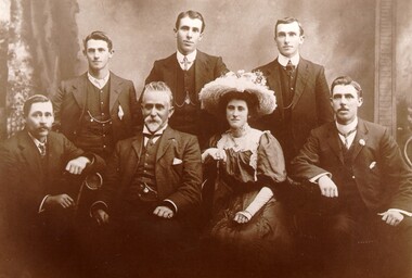
Photograph - Digital image, c. 1900
Aged 17, Edwin Thomas Penny took over the 10 acres of freehold land held by his deceased father, Thomas Penny. Edwin Penny developed a reputation as an innovative orchardist and market gardener who grew apples, plums, passion fruit, peaches, pears, and lemons, and between the trees he planted potatoes, rhubarb and other vegetables.Sepia toned digital image of the Penny family. Back row left to right: Clifford Penny, Reubin Penny, Edwin Penny. Front row left to right: Albert Penny, Edwin Thomas Penny, Hilda Penny and Lytton Pennymarket garden, orchards, fruit, vegetables, moorabbin, cheltenham -
 Melbourne Legacy
Photograph, Back to Caulfield 1995, 1995
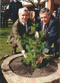
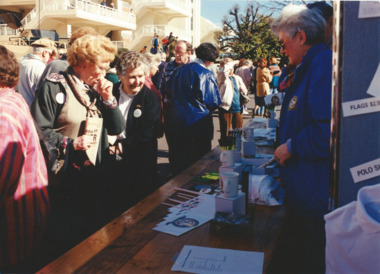
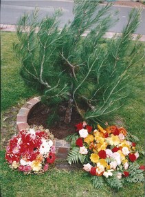
For many years Legacy had a "Back to Caulfield Race Day" for Legatees, widows and their families. 1995 was the 50th anniversary of the end of World War 2 and the race day was part of the "Australia Remembers" commemorations. Also a Legacy 'Lone Pine' was planted. The article in the Answer says: "Over 800 members of the Legacy family (past and present) reunite at the "Australia Remembers" Back to Caulfield Commemorative Race Day held on August 12th. It was a special day which incorporated a wide range of activities, including a display of military vehicles, a flyover, a parachute jump by the Red Berets, military bands, and displays of memorabilia when the racecourse was used as an army camp. An official ceremony also included the presentation of a Legacy 'Lone Pine' (a descendant of the Gallipoli 'Lone Pine') by the President of the Melbourne Legacy, Legatee David Millie, which was very warmly received by the Chairman of the V.A.T.C., Mr Peter Lawrence. " Official guest was the Premier of Victoria Jeff Kennett who is seen being greeted as he arrives. And photos of the planting of the 'Lone Pine'. See also photos at 01003 and 01092 and 01093. Legacy is helping to keep the memory of the Gallipoli "Lone Pine" alive - its spirit living on today. Presentations are made to schools, ex-service organisations and interested bodies by Legacy Clubs in the hope that they will be cherished as a symbol of nationhood and of its just pride, devotion, courage, selflessness and sense of service to others.Legacy retains a tie with Caulfield racecourse as it was once an army camp and staging post of young men going overseas to war and now it is the site of a lone pine. The annual gathering at Caulfield racecourse was an event that gets the Legacy family together.Colour photo x 8 of an event at Caulfield racecourse, and an article in The Answer.Printed on the back film number 783, 786, 787, various frame numbersanswer, events, lone pine, wreath laying ceremony -
 Melbourne Legacy
Photograph, Back to Caulfield 1995, 1995
For many years Legacy had a "Back to Caulfield Race Day" for Legatees, widows and their families. 1995 was the 50th anniversary of the end of World War 2 and the race day was part of the "Australia Remembers" commemorations. Also a Legacy 'Lone Pine' was planted. The article in the Answer says: "Over 800 members of the Legacy family (past and present) reunite at the "Australia Remembers" Back to Caulfield Commemorative Race Day held on August 12th. It was a special day which incorporated a wide range of activities, including a display of military vehicles, a flyover, a parachute jump by the Red Berets, military bands, and displays of memorabilia when the racecourse was used as an army camp. An official ceremony also included the presentation of a Legacy 'Lone Pine' (a descendant of the Gallipoli 'Lone Pine') by the President of the Melbourne Legacy, Legatee David Millie, which was very warmly received by the Chairman of the V.A.T.C., Mr Peter Lawrence. Official guest was the Premier of Victoria Jeff Kennett Photos include the military vehicles, the stalls, and some of the racing. See also photos at 01003 and 01091 and 01093.Legacy retains a tie with Caulfield racecourse as it was once an army camp and staging post of young men going overseas to war and now it is the site of a lone pine. The annual gathering at Caulfield racecourse was an event that gets the Legacy family together.Colour photo x 14 of an event at Caulfield racecourse, and an article in The Answer.Printed on the back film number 783, 786, 787, various frame numbers.answer, events, horses, tanks, drummers, fly past -
 Melbourne Legacy
Photograph, Back to Caulfield 1995, 1995
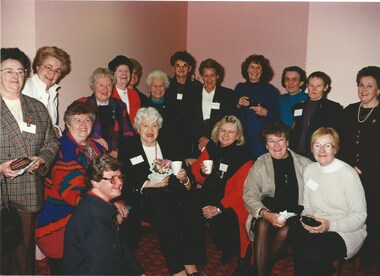
For many years Legacy had a "Back to Caulfield Race Day" for Legatees, widows and their families. 1995 was the 50th anniversary of the end of World War 2 and the race day was part of the "Australia Remembers" commemorations. Also a Legacy 'Lone Pine' was planted. The article in the Answer says: "Over 800 members of the Legacy family (past and present) reunite at the "Australia Remembers" Back to Caulfield Commemorative Race Day held on August 12th. It was a special day which incorporated a wide range of activities, including a display of military vehicles, a flyover, a parachute jump by the Red Berets, military bands, and displays of memorabilia when the racecourse was used as an army camp. An official ceremony also included the presentation of a Legacy 'Lone Pine' (a descendant of the Gallipoli 'Lone Pine') by the President of the Melbourne Legacy, Legatee David Millie, which was very warmly received by the Chairman of the V.A.T.C., Mr Peter Lawrence. Official guest was the Premier of Victoria Jeff Kennett Photos include groups of Legacy Widows and dependents enjoying the day. Onename tag is legible - Kate Brettoner. See also photos at 01003 and 01091 and 01092.Legacy retains a tie with Caulfield racecourse as it was once an army camp and staging post of young men going overseas to war and now it is the site of a lone pine. The annual gathering at Caulfield racecourse was an event that gets the Legacy family together.Colour photo x 12 of an event at Caulfield racecourse, and an article in The Answer.Printed on the back film number 783, 786, 787, various frame numbers.answer, events -
 Melbourne Legacy
Photograph, Back to Caulfield 1995, 1995
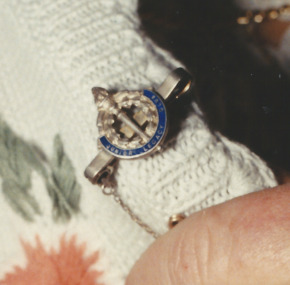
For many years Legacy had a "Back to Caulfield Race Day" for Legatees, widows and their families. 1995 was the 50th anniversary of the end of World War 2 and the race day was part of the "Australia Remembers" commemorations. Also a Legacy 'Lone Pine' was planted. The article in the Answer says: "Over 800 members of the Legacy family (past and present) reunite at the "Australia Remembers" Back to Caulfield Commemorative Race Day held on August 12th. It was a special day which incorporated a wide range of activities, including a display of military vehicles, a flyover, a parachute jump by the Red Berets, military bands, and displays of memorabilia when the racecourse was used as an army camp. An official ceremony also included the presentation of a Legacy 'Lone Pine' (a descendant of the Gallipoli 'Lone Pine') by the President of the Melbourne Legacy, Legatee David Millie, which was very warmly received by the Chairman of the V.A.T.C., Mr Peter Lawrence. These photos show President David Millie and Legacy widow Rosie Ellis (Bell) and a close up of her Junior Legacy badge, perhaps she had originally been an Junior Legatee. He is shown pointing her badge out to other people gathered around. See also photos at 01003 and 01091, 01092 and 01093.This is a good image of a Junior Legacy badge. Legacy retains a tie with Caulfield racecourse as it was once an army camp and staging post of young men going overseas to war and now it is the site of a lone pine. The annual gathering at Caulfield racecourse was an event that gets the Legacy family together.Colour photo x 4 of a Junior Legacy badge and an event at Caulfield racecourse, and an article in The Answer.Printed on the back film number 788, various frame numbers.answer, events -
 Melbourne Legacy
Document, Gallipoli's 'Lone Pine' Lives On
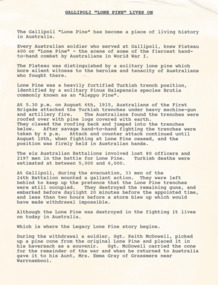
A detailed account of the story of Lone Pine in Gallipoli and how seedlings were grown from a pine cone brought back by Sgt. Keith McDowell. The author and date of this account is not known but was post 1989. The text says: " Gallipoli Lone Pine Lives On The Gallipoli Lone Pine has become a piece of living history in Australia. Every Australian solider who served at Gallipoli, knew Plateau 400 or ‘Lone Pine’ – the scene of some of the fiercest hand-to-hand combat by Australian in World War 1. The Plateau was distinguished by a solitary lone pine which bore silent witness to the heroism and tenacity of Australians who fought there. Lone Pine was a heavily fortified Turkish trench position, identified by a solitary Pinus Halepensis species commonly known as an ‘Aleppo Pine’. (** NB this has since been corrected and the species is not an 'Aleppo pine' but Pinus Brutia, commonly called Turkish pine) At 5.30 pm on August 6th, 1915, Australians of the First Brigade attacked the Turkish trenches under heavy machine-gun and artillery fire. The Australians found the trenches were roofed over with pine logs covered with earth. They clawed the roofing back and jumped into the trenches below. After savage hand-to-hand fighting the trenches were taken by 6 pm. Attack and counter attack continued until August 10, when fighting at Lone Pine ceased, and the position as firmly held in Australian hands. The six Australian Battalions involved lost 80 officers and 2197 men in the battle for Lone Pine. Turkish deaths were estimated at between 5,000 and 6,000. At Gallipoli during the evacuation, 33 men of the 24th Battalion mounted a gallant action. They were left behind to keep up the pretence that the Lone Pine trenches were still occupied. They destroyed the remaining guns, and embarked before daylight 20 minutes before the appointed time, and less than two hours before a storm blew up which would have made withdrawal impossible. Although the Lone Pine was destroyed in the fighting it lives on today in Australia. Which is where the Legacy Lone Pine story begins. During the withdrawal a soldier, Sgt. Keith McDowell, picked up a pine cone from the original Lone Pine and placed it in his haversack as a souvenir. Sgt. McDowell carried the cone for the remainder of the war and when he returned to Australia gave it to his Aunt, Mrs Emma Gray of Grassmere near Warrnambool. “Here Aunty, you’ve got a green thumb, see if you can grow something out of this”, the late Mrs Gray’s son, Alexander, recalled. But it wasn’t until some 12 years later that Mrs Gray planted the few seeds from the cone, five of which sprouted and grew into little trees. One of the pines eventually died but the remaining four survived. In May, 1933, one was planted in Wattle Park on the occasion of the Trooping of the Colour by the 24th Battalion. On the 11th June 1933, the second tree was planted with full military honours by S G Savige of the 24th Battalion, at the Shrine of Remembrance in Melbourne, where it now shades the well-loved statue of Simpson and his donkey. The late Lieutenant-General Sir Stanley Savige KBE, CB, DSO, MC, ED, was the founder of Melbourne Legacy. Formed in 1923, the Melbourne Legacy Club was the first such Club to be established. On the 18 June 1933 the third tree was planted at the Sisters, near Terang, just north east of Warrnambool. This is the area Mrs Gray’s family lived and the home of several Gallipoli veterans. The fourth tree was planted in the Warrnambool Gardens on 23 January 1934. In 1964 Legatee Tom Griffiths, then President of Warrnambool Legacy, put forward the idea that more seedlings should be raised in the Jubilee Year of Gallipoli from the established trees with the object of planting memorial trees throughout Australia in memory of those who fell in action at Lone Pine in 1915. The project was outlined in a paper presented to the Perth Conference in 1965 and was strongly supported. Two batches of cones were sent to Melbourne, one from the tree at ‘The Sisters’ and another from the tree at the Warrnambool Gardens, and the full cooperation of the (then) Forests Commission of Victoria, was guaranteed by the Chief Commissioner, Mr Benallack. Unfortunately, these cones had been gathered too late as the seeds had already been cast, and the few seeds that survived failed to germinate. However, Melbourne Legacy then undertook the propagation and distribution of seedlings. With the assistance of the Shrine of Remembrance Trustees, permission was granted by the Melbourne City Parks and gardens Curator to harvest a limited number of cones from the 24th Battalion tree at the Shrine and these were gathered by the Forest Commission and after the necessary preparatory treatment were planted in the Commission’s nursery at Macedon. Approximately 150 seedlings were raised from these cones by Dr Grose, Director and Silviculture. Melbourne Legacy’s Commemoration Committee was responsible for the collection, propagation, presentation and dedication of Lone Pines from the 24th Battalion tree at the Shrine of Remembrance. One the 14 September 1989 further cones were collected with the hope to raise 1000 trees from the seeds. This could not have been done without the invaluable assistance of the Department of Natural Resources and Dr Peter May at the Victorian College of Agriculture and Horticulture in Richmond, Victoria. Thus, Legacy is helping to keep the memory of the Gallipoli ‘Lone Pine’ alive – its spirit living on today. Presentations are made to schools, ex-service organisations and interested bodies by Legacy Clubs in the hope that they will be cherished as a symbol of Australian nationhood and of its just pride, devotion, courage, selflessness and sense of service to others. "The Legacy Lone Pine program helped promote the Anzac story throughout Australia.White A4 paper with black type x 3 pages recounting the story of Legacy's propagation of Lone Pine seedlings. lone pine, gallipoli -
 Melbourne Legacy
Photograph, Back to Caulfield 1995, 1995
For many years Legacy had a "Back to Caulfield Race Day" for Legatees, widows and their families. 1995 was the 50th anniversary of the end of World War 2 and the race day was part of the "Australia Remembers" commemorations. Also a Legacy 'Lone Pine' was planted. The article in the Answer says: "Over 800 members of the Legacy family (past and present) reunite at the "Australia Remembers" Back to Caulfield Commemorative Race Day held on August 12th. It was a special day which incorporated a wide range of activities, including a display of military vehicles, a flyover, a parachute jump by the Red Berets, military bands, and displays of memorabilia when the racecourse was used as an army camp. An official ceremony also included the presentation of a Legacy 'Lone Pine' (a descendant of the Gallipoli 'Lone Pine') by the President of the Melbourne Legacy, Legatee David Millie, which was very warmly received by the Chairman of the V.A.T.C., Mr Peter Lawrence.Legacy retains a tie with Caulfield racecourse as it was once an army camp and staging post of young men going overseas to war and now it is the site of a lone pine. The annual gathering at Caulfield racecourse was an event that gets the Legacy family together.Colour photo x 3 of an event at Caulfield racecourse, and an article in The Answer.Printed on the back film number 786 No. 7A and No. 19A. Film number 787 No. 9A.events, wreath laying ceremony, answer -
 Melbourne Legacy
Photograph, Back to Caulfield 1996, 1996
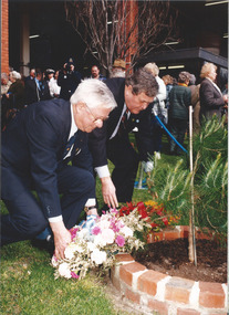
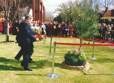
For many years Legacy had a "Back to Caulfield Race Day" for Legatees, widows and their families. In 1995 a Legacy 'Lone Pine' was planted. The article in the Answer says: “We were delighted with the many Legacy Widows, Legatees and friends of Legacy who participated in the Commemorative Race Day at Caulfield Sunday 25th August - marking the 75th anniversary of the RAAF. The VATC had a range of displays and activities including a breathtaking parachute demonstration by the Blue Eagles. It was touch and go for a while due to the weather conditions but once the Blue Eagles jumped they all reached their designated target in front of the winning post. Legacy even had a special race named after it: “The Legacy Widows Appeal Handicap”. Our thanks to the VATC for this courtesy. Hope we had a few winners! Vice President, Legatee Brian ‘Lucky’ Luscombe placed a wreath at the legacy ‘Lone Pine’ - a descendant of the Gallipoli ‘Lone Pine’ on behalf of the Legacy Family. The historic tree was presented to Caulfield last year as part of the events to mark the 1995 Australia Remembers year.” The photos show children playing mini golf as well as the Historical Re-enactment Society of Australia with old military equipment and wearing old military uniforms. The racecourse also had a vintage plane on display with military vehicles.Legacy retains a tie with Caulfield racecourse as it was once an army camp and staging post of young men going overseas to war and now it is the site of a lone pine. The annual gathering at Caulfield racecourse was an event that gets the Legacy family together.Colour photo x 18 of an event at Caulfield racecourse in 1996 and an article in The Answer.Printed on back events, wreath laying ceremony, answer -
 Melbourne Legacy
Photograph, Back to Caulfield 1997, 1997
For many years Legacy had a "Back to Caulfield Race Day" for Legatees, widows and their families. In 1995 a Legacy 'Lone Pine' was planted. President Luscombe laid a wreath at the Lone pine tree. The article in the Answer says: "In spite of a somewhat 'windy' day for out "Back to Caulfield" race day, it was another success. Our President Legatee Brian (Lucky) Luscombe and Mr Peter Lawrence, Chairman of the VATC both made a speech and each laid a wreath at our 'Lone Pine' tree - a descendant of the Gallipoli 'Lone Pine'. Our pine tree was getting blown around ferociously, but its roots are firm - just like Legacy."Legacy retains a tie with Caulfield racecourse as it was once an army camp and staging post of young men going overseas to war and now it is the site of a lone pine. The annual gathering at Caulfield racecourse was an event that gets the Legacy family together.Colour photo x 7 of an event at Caulfield racecourse, and an article in The Answer.events, wreath laying ceremony, answer -
 Melbourne Legacy
Photograph, Back to Caulfield 1998, 1998
For many years Legacy had a "Back to Caulfield Race Day" for Legatees, widows and their families. In 1995 a Legacy 'Lone Pine' was planted. In these photos in 1998 President Tom Butcher laid a wreath at the Lone pine tree. There was a speech by the Legacy President and a wreath laying at the Lone Pine that had been planted in 1995. Legacy retains a tie with Caulfield racecourse as it was once an army camp and staging post of young men going overseas to war and now it is the site of a 'lone pine'. The annual gathering at Caulfield racecourse was an event that gets the Legacy family together.Colour photo x 13 of an event at Caulfield racecourse.Printed on the back film numbers 972 and 974. Yellow post it note said Back to Caulfield 1998.events, wreath laying ceremony -
 Melbourne Legacy
Audio - Newsletter, The Answer June/July 2021 Audio Version, 2021
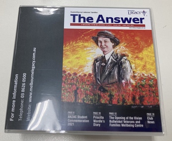
The Answer is a newsletter in magazine format that is sent to the widows that are helped by Melbourne Legacy. For the widows who are sight impaired a copy of the newsletter is audio described onto CD by Vision Australia and posted to them. It contains information about meetings and activities. This edition contained articles on the Legacy Anzac Biscuit Bake Off, the opening of the Vivian Bullwinkel Veterans and Families Wellbeing Centre, and a planting of a Lone Pine seedling at Cobram Secondary College. Plus photos of our programs such as the Student Anzac ceremony, Path of the Horse family day, the walking group, the stamp ladies, adults with a disability program days, widows club gatherings. The Vivian Bullwinkel Veterans and Families Wellbeing Centre on the 3rd floor of Legacy House was opened on the 13 April 2021. It provides the veterans and their families a safe haven to access essential support services such as advocacy, case management and referral pathways whilst inviting them to relax within a 'club' like environment equipped with lounging and children's play areas, and both kitchen and bathroom facilities. It was named in honour of an Australian Army nurse who was the lone survivor of the Bangka Island massacre, and who dedicated her life to nursing. The exceptional portrait of Vivian Bullwinkel on the cover was painted by George Petrou. A record that Melbourne Legacy helps coordinate and organise events and activities for the widows, and provides items of interest for their enjoyment.Compact disc x 2 in a case that contains the audio recording of The Answer from June/July 2021.activities, answer, widows -
 University of Melbourne, Burnley Campus Archives
Photograph - Colour print, Marquee Construction in Gardens, 1996
4 colour photographs showing the construction of a marquee for the Smorgan family wedding in 1996 and the damage to the plantsmarquees, smorgan family, wedding, 1996, damage to gardens -
 Trafalgar Holden Museum
Vehicle - EK Special Holden sedan, 1961
The EK was the first model Holden that had the option of automatic transmission. This was the 3 speed hydra-matic that offered performance and economy that was not far short of the manual. This vehicle still used the tried and true 138 cubic inch power plant.This was a local Trafalgar vehicle formerly owned by Graham Cook and family. The interior of this vehicle is totally original while the exterior has undergone a substantial repaint and re-chrome, This was required because the previous owner kept the external spotlessly clean and wore the paint out.Blue body sedan with white roof ,sun visor, upright rear vision mirrors added on .Hub caps featured lion emblem. Chrome arrow shape ornament on bonnet.Holden Special Registered number 63453-Hvehicle, holden, 1961, car -
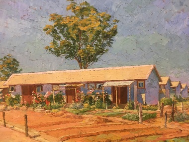 Tatura Irrigation & Wartime Camps Museum
Painting - Painting - oil, Family Barracks at Camp 3
Vagarini was an Italian painter at Camp 3 Tatura. He was arrested in Palestine and sent to Australia on the Queen Elizabeth.ModernistFour rows of huts. Flower gardens are planted at the front of the first hut. Rows of red dirt in the foreground. Bright blue sky and a large tree growing at the back of the first hut and is in the centre of the picture. R. Wied wrtitten on back of painting.Cesare Vagarini -
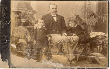 Bendigo Historical Society Inc.
Photograph - FAMILY PORTRAIT C1900, approx 1900
BHS Collectionsepia toned photo: family group, male in centre with small boy left side, small girl on right. Victorian setting. Cane furniture and various plants. Dog at front.'Bartlett Bros. Bendigoperson, family -
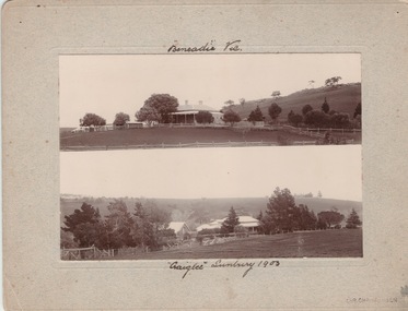 Sunbury Family History and Heritage Society Inc.
Photograph, Vineyards - Ben Eadie and Craiglee, 1903
The two homesteads are Ben Eadie and Craiglee, which were two of Sunbury's earliest vineyards that were established in Sunbury. James Stewart Johnson designed and built his concrete home, Craiglee, in 1865 where the previous year he had planted out his vineyard on the surrounding 26 acres of land.The property was on the east side of Jacksons Creek on Macedon Road. He concentrated growing Riesling and Hermitage grapes. After his death in 1896, his son Wilfred continued to produce wines until the late 1920s, when he pulled out the vines and concentrated on raising sheep for wool and meat. The Carmody family purchased the property in 1961 and in 1976 decided to replant the vineyard. Ben Eadie was built some time in 1863 and settled by the Eadie family who also were millers. The winery was built into the side of a hill close to the house but the Eadie family tended to concentrate on milling and retailing.In the earliest days of European settlement many wineries were established in the Sunbury area.Two non-digital sepia photographs have been mounted on cardboard. They are photographs of two homesteads with bare hills in the background. They were built in Sunbury in the early days off European settlementBen Eadie Vic. Craiglee Sunbury 1903john eadie, ben eadie winery, james stewart johnson, craiglee, wineries, vineyards -
 Warrnambool and District Historical Society Inc.
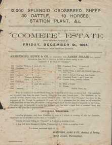
Document - Advertisement, Coomete estate, Sale of stock and plant, 1894
Augustus Bostock was the 9th child of Robert & Rachael Bostock of Vaucluse Epping Forest, Van Diemen’s Land. He was only 4 years old when his mother died. He was inspired by his father to seek his fortune in the Western District of Victoria. He arrived around 1850. He married Margaret Aitkin in July 1865. Augustus owned several properties in the district and leased others. He sat on the court of Warrnambool, Mortlake or Hexham as required. He resided at Marramook in Hawkesdale and later moved to Vaucluse in Hopetoun Road Warrnambool, where he died in 1920 at the age of 87. He was involved in many aspects of life in the Western District, racing, cricket, and social activities to name a few. This flyer is advertising the sale of 12000 sheep, 30 cattle, 10 horses and station plant at the expiration of the lease of Coomete. It states that Coomete has been in the possession of Mr. Augustus Bostock for over 30 yearsThis is one of a number of documents which relate to the Bostock family who were one of the most important pioneering families of the Western District. They owned and leased various properties around Warrnambool and were involved in many aspects of social and business life. This document contains a detailed view of the stock owned by Augustus Bostock at Coomete. From a social perspective the details provided show that it was an event of some importance in the farming area.Cream paper with heading and title in large font at the top with Coomete Estate in uppercase inside banner lines underneath with details of stock and numbers to be sold in smaller print below. Mercer printer Geelong. For further particulars apply to Armstrong, Howe & Co Geelong and Terang, James Jellie Warrnambool.coomete, warrnambool, augustus bostock, coomete lease, 1894 -
 Williamstown Botanic Gardens- Hobsons Bay City Council
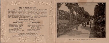
Work on paper - Ephemera - Williamstown Botanic Gardens - 1934 Reception Card, 1934
The card for the Civic Reception at Williamstown Town Hall for the ‘Back to Williamstown’ celebrations – the centenary from date of first settlement in 1834. It belonged to James and Kate Tyrrell, the paternal grandparents of the Donor. The donor is the third generation of her family to live in Williamstown. Having a photo of the Gardens in the reception card is evidence of the community pride of the Gardens. The photo is evidence of plantings in 1934 A folded sepia look card. The front has an embossed border, the City of Williamstown Shield, date in the right bottom corner and an inscription as described. The left fold inside demonstrates the reverse of the embossed border and details of the City of Williamstown and Councillors. The right side fold inside is a photo of people walking along ‘The Main Walk, Williamstown Gardens’. The back has space for ‘Autographs.’williamstown botanic gardens, hobsons bay city council, city of williamstown, williamstown gardens, 1934, councillors, james taylor gray, henry johnston harvey, william gordon gray, walter stuart menzies, james adolphus nelson, evan charles owens, john robert bell, john anthony dennis, allan john deacon, oliver prettie chanter, william roberts, george alexander paine, james hocking, harold rose, norman hodgson -
 Buda Historic Home & Garden Castlemaine
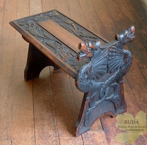
Domestic furniture, Timber hand-carved boot stool, c1900
The British Arts and Crafts Movement was a major influence on handcrafts made by the Leviny women at Buda. This Movement spread knowledge of craft techniques in the decorative arts and encouraged women to partake in fields that had traditionally been the domain of men, such as metalcraft and woodwork. The Leviny women studied art, design and craft techniques at the Castlemaine School of Mines from the 1890s to the early 1900s and this boot stool, hand-carved by Gertrude, is an example of the influence of the Arts and Crafts Movement on her decorative art. See: Zilles, Lauretta (2010), Buda and the Leviny Family, Castlemaine: Buda Historic Home & Garden Inc.This is a rare example of a unique hand-carved boot stool made in Australia by Gertrude Leviny in the British Arts and Crafts Movement style at the turn of the twentieth century.Timber boot stool, hand-carved by Gertrude Leviny. Made using the 'chip carving' technique, with dragon heads on upright at one end, and plant design in relief on the seat. Timber finish has a blackened effect.'K/40' (Old Registration Number)gertrude leviny, wood carving, arts and crafts movement, buda, castlemaine, dragon's heads, c1900, domestic furniture, castlemaine school of mines -
 Linton and District Historical Society Inc
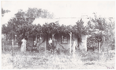
Photograph, Crosier Family Home at Happy Valley
This photograph is believed to have been taken in the 1890s at the Crosier property at Happy Valley (the Crosiers lived along the road leading to the Happy Valley School. Crosier descendants still live on this site). People in the photo are thought to be, L-R: Nell Crosier, Mary Crosier (née Hogan), Maggie Crombie (née Crosier), Jack Crombie. Mary Crosier was the second wife of Henry Crosier (1825-1901), a miner and farmer at Happy Valley. They had eight children. Their oldest daughter Maggie Crosier (1865-1932) married John Charles (Jack) Crombie in 1893. The Crombies farmed at Durham Lead.Black and white copy of original photograph showing a small weatherboard house with climbing plants along the verandah. Standing in front of the house are two women, with an older lady sitting between them, and a gentleman standing on the right, next to one of the women.crosier family home, miss crosier, mrs crosier, jack crombie, maggie crombie (nee crosier), happy valley -
 Eltham District Historical Society Inc
Photograph - Digital Photograph, Alan King, Memorial to Peter Brock, Ferguson's Paddock, Hurstbridge, 23 January 2008
Ferguson’s Paddock, Hurstbridge. A plaque on a boulder commemorates Peter Brock. Published: Nillumbik Now and Then / Marguerite Marshall 2008; photographs Alan King with Marguerite Marshall.; p167 On a rock in Ferguson’s Paddock, Hurstbridge, a plaque commemorates Peter Brock. It includes the words: ‘Boy from Hurstbridge without special privileges, grew to become champion of racetracks around the world but he never forgot his beginnings’. Brock came from a well-established local family. Born in Hurstbridge in 1945, he lived in Anzac Avenue as a child, attended the Hurstbridge Primary and Eltham High Schools and lived in the district most of his life. His father Geoff owned the Diamond Valley Speed Shop in Greensborough. Brock’s forbears were amongst the area’s earliest settlers. From Scotland, the Brocks arrived in Tasmania in 1830, to graze sheep. Family members moved to Sunbury, then Preston, grazing sheep in the Bundoora area. John Brock owned Janefield, possibly named after his wife. In 1855 he granted around two acres (0.8ha) of his estate for a school.1 In 1866 Lewis Brock bought 264 acres (107ha) in Nutfield, the first non-Aboriginal person to own that land. They planted an orchard, then from around 1935, Brock’s uncle Sandy and his grandfather Lewis, ran a dairy on the property. In the 1980s Brock and his then partner Bev, bought most of the property, which they sold after their separation in 2006. Brock’s father was a Hurstbridge Football Club President, but Brock’s uncle Sandy, of Brocks Road, Doreen, has been particularly active in local affairs. He was President of the Mernda Football Club (then Plenty Rovers), President of the Panton Hill Football League and he founded the Arthurs Creek and District Landcare Group. He also gave more than 50 years of service to the Whittlesea Agricultural Society, the Volunteers for Australian Football and the Doreen Rural Fire Brigade. Community service was important to Brock too. Brock, with his then partner Bev, established the Peter Brock Foundation in 1997, the year he retired from full-time V8 Supercar racing. The Foundation’s grants have included $100,000 towards the upgrade of a walking track in the Hurstbridge Parklands and other projects include a holiday house for the families of child cancer victims. Brother Lewis saw Brock as a spiritual person, who had a great affinity with people. He saw Brock as a role model of someone who could achieve their dreams. ‘The family didn’t have much money, yet that didn’t stop Peter realising his dreams. He was strong and didn’t let difficult times crush him.’ Despite his later successes, Brock’s most treasured trophy was for running 100 yards (91.4m)at his primary school in 1955, and he appreciated his head master Ted Griffiths’ encouragement of his sporting endeavours. At high school Brock became captain of Everard House. In his first year he bought a 1928 Austin 7 for £5. He cut the car into a box shape with an axe and enjoyed driving it – despite it having no brakes - at his grandparents’ farm at Nutfield. The turning point in Brock’s life came at age 23, when he built an Austin A30 in an old henhouse in Wattle Glen, using a Holden engine. He was laughed at until it won the Australian Sports Sedan Championship in 1968. Brock’s career then took off and he became a professional driver. Brock won Australian motor sport’s best-known event, the Bathurst 1000, nine times. Brock endured a bitter split from Holden in 1986 over control of his Holden-backed vehicle modification business and a car performance-enhancing device he called the ‘energy polariser’– despite it having no scientific evidence to support its claims. But Brock returned to Holden in 1994. Then in 1997, aged 52, Brock retired from fulltime V8 Supercar racing. However he continued to race at motor sport events. Brock won several awards, including an Order of Australia Medal in 1980, the Australian Sports Medal in 2000, and the Centenary Medal. On September 8, 2006, Brock died; after his car hit a tree during the Targa West Rally in Western Australia.This collection of almost 130 photos about places and people within the Shire of Nillumbik, an urban and rural municipality in Melbourne's north, contributes to an understanding of the history of the Shire. Published in 2008 immediately prior to the Black Saturday bushfires of February 7, 2009, it documents sites that were impacted, and in some cases destroyed by the fires. It includes photographs taken especially for the publication, creating a unique time capsule representing the Shire in the early 21st century. It remains the most recent comprehenesive publication devoted to the Shire's history connecting local residents to the past. nillumbik now and then (marshall-king) collection, ferguson's paddock, hurstbridge, peter brock memorial, peter brock -
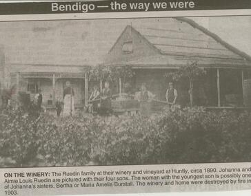 Bendigo Historical Society Inc.
Newspaper - JENNY FOLEY COLLECTION: ON THE WINERY
Aime Louis Ruedin (1847- 5/6/1896) was the son of Swiss immigrants Louis and his wife Catherine Schiener. Aime married Johanna Haemsen (1850 - 1909). in 1870. They planted extensive vineyards at Huntly and supplemented their income by selling fruit from their orchards. They had 7 children. In May 1903, fire began in the Ruedin home and spread to the winery. Some vats and winemaking equipment were save but approx 4000 gallons of casked wine was lost.Bendigo Advertiser ''The way we were'' from Tuesday, December 9, 2003. On the winery: the Ruedin family at their winery and vineyard at Huntly, circa 1890, Johanna and Aimie Louis Ruedin are pictured with their four sons. The woman with the youngest son is possibly one of Johanna's sisters, Bertha or Maria Amelia Burstall. The winery and home were destroyed by fire in 1903. The clip is in a folder.newspaper, bendigo advertiser, the way we were -
 Eltham District Historical Society Inc
Photograph, Peter Pidgeon, Dedication of a Golden Wattle in memory of Harry Gilham and Sue Law, Local History Centre, 728 Main Road, Eltham, 12 April 2024
A Golden Wattle tree was planted in memory of Eltham District Historical Society life members Harry Gilham (24 Mar 1928-25 Feb 2024; EDHS President 1993-2009) and Sue Law (27 Sep 1937-8 Aug 2023; EDHS President 1985-1993, Vice President 1993-1998 & 2009-2015). Close members of Harry’s and Sue’s families along with EDHS Committee members and life member Doug Orford joined in a dedication ceremony to commemorate their contributions, on Friday 12 April at 10.00am, in the rear yard at the Local History Centre, 728 Main Road, Eltham, on the corner of Brougham Street. EDHS President Jim Connor welcomed family members and acknowledged the dedicated efforts of both Harry and Sue over a long period of years. After unveiling of the plaque, attendees enjoyed some morning tea and sharing stories of Harry and Sue.Born Digital (15 images)activities, eltham district historical society, local history centre, main road, eltham, alison delaney, dedication, doug orford, gilham family, golden wattle, harry gilham, irene kearsey, jim connor, joan castledine, law family, peter & elizabeth pidgeon collection, plaques, richard pinn, robert marshall, russell yeoman, sue dyet, sue law -
 Eltham District Historical Society Inc
Photograph - Digital Photograph, Alan King, Queenstown Cemetery, Smiths Gully Road, St Andrews, 28 December 2007
The discovery of gold in Smyth's Creek in 1854 and subsequent gold rush to the Caledonia diggings led to the establishment of Queenstown (present day St Andrews). The first recorded burial was July 31st, 1861 and it was officially declared a Cemetery Reserve in 1866. Many graves are unmarked and unrecorded including many Chinese and other itinerant miners. The cemetery was closed for new burials in 1851. The last recorded burial was in 1981 in an existing family grave. In Loving memory of David Band Died 30th Decr. 1862, aged 51 years. John Cork Knell Died 11th April 1867, aged 42 years. Eliza Smith Died 20th Jany. 1874, aged 3 1/2 years. William Band Died 20th Feby. 1883, aged 51 years. Published: Nillumbik Now and Then / Marguerite Marshall 2008; photographs Alan King with Marguerite Marshall.; p73 The discovery of gold at Smyth’s Creek* in 1854 brought 3000 people to the area in search of their fortunes.1 However in the harsh conditions many miners and their families died young, and were buried in unmarked graves. Their stories died with them but by 1861, the first burial was recorded at the Queenstown Cemetery – that of William Dalrymple aged 65 – although the cemetery was only officially declared a reserve in 1866. Even before this in 1856, a double burial had been recorded for the twin baby daughters of George Harrison at Market Square, the miners’ settlement – presumably where the cemetery is today. In 1951 the Queenstown Cemetery at 70 Smiths Gully Road, Smiths Gully, closed for burials. However the last burial in a family plot, that of Grace Evelyn Smith, occurred in 1981. Today only 55 headstones remain, but more than 380 burials are recorded. Remnant bushland dominates the cemetery where many graves are merely mounds and others have been damaged by vandalism and the neglect of time. Bushfire in 1962 destroyed the picket fencing, grave markers and cypress boundary planted in the early 1900s. The box/stringybark woodland in the 1.7 hectare Cemetery Reserve is regrowth from then and the indigenous and heritage vegetation is protected. Thanks to the volunteer Cemetery Trust and Friends & Relations of Queenstown Cemetery, the cemetery is maintained, stories recorded and the burial index corrected and expanded.2 Close by the cemetery on the site of today’s Peter Franke Picnic and Nature Reserve stood Market Square, the Caledonia Diggings village of tents and stores, the forerunner of Queenstown, now St Andrews. Many of the Caledonia Diggings miners were Chinese, many of whom, with itinerant prospectors, were buried in unmarked graves. Histories are being recorded of other immigrants, mainly English and German, who settled after the gold rush, some of whose descendants fought and died in the two world wars. Names on many headstones are also recorded on the district’s roads, reserves and war memorials such as Motschall, Joyce, Howard and Coutie. The oldest surviving tombstone is that of Scot, David Band who died in 1862 at 51 years. His oldest daughter Elizabeth, with husband John Knell, owned the Queenstown Hotel and the post office. Child-rearing in a colonial gold town was often tragically difficult, as demonstrated in the first 20 years, when 41% of the 34 burials recorded were children. Settlers endured harsh conditions graphically illustrated with the deaths of Annie Joyce at 30 years and of her family. Annie was married to gold miner Walter Joyce. Their third child Walter, born in 1886, died in March 1887. Eight months later Annie died of breast cancer. Walter died in 1909, aged 53, of miner’s phthisic caused by stone dust destroying his lungs. It was so hard to make a living that burials were usually held from 2.30 pm to allow mourners to work a day before paying their last respects.3 Most burials before 1890 were recorded as Anglicans, as the only church on the Caledonia Diggings was the Church of St Andrew, until 1897, when the Primitive Methodist Church came to Panton Hill. Generally miners came to better themselves, but some, like Grace Hopkinson (nee Milward), born in England in 1828, came from a well-off and educated family. According to family legend Grace emigrated with husband William, to live in a tent, but had kept her personally embossed sterling silver cutlery service. Amid the tough environment were some successes like that reported in The Evelyn Observer April/May 1901 of miner William Hopkinson who was buried at the cemetery in 1912 aged 81. The Observer stated that Hopkinson ‘recently dropped across another find in his claim at One Tree Hill’. The lump of gold found this time weighed more than half a kilo. Mr Hopkinson referred to it as ‘another little speck’. *Today’s Smiths GullyThis collection of almost 130 photos about places and people within the Shire of Nillumbik, an urban and rural municipality in Melbourne's north, contributes to an understanding of the history of the Shire. Published in 2008 immediately prior to the Black Saturday bushfires of February 7, 2009, it documents sites that were impacted, and in some cases destroyed by the fires. It includes photographs taken especially for the publication, creating a unique time capsule representing the Shire in the early 21st century. It remains the most recent comprehenesive publication devoted to the Shire's history connecting local residents to the past. nillumbik now and then (marshall-king) collection, david band, eliza smith, gravestones, john cork knell, queenstown cemetery, smiths gully road, st andrews, william band -
 Eltham District Historical Society Inc
Photograph - Digital Photograph, Alan King, Site of the Diamond Creek Gold Mine, 28 December 2007
The largest gold mine in the area originated from a find in 1862. The mine was closed January 20, 1915 when a fire destroyed nearly all the above ground plant. Published: Nillumbik Now and Then / Marguerite Marshall 2008; photographs Alan King with Marguerite Marshall.; p75 Beneath Mine Hill, as locals call it, runs a network of tunnels once of central importance to the fledgling township of Diamond Creek. These are relics of gold mines, which transformed early Diamond Creek.1 The tiny settlement of about 20 families soared to more than 200 because of gold. For around 50 years, from 1862, gold mining was Diamond Creek’s major source of employment. On September 7, 1854 The Argus newspaper reported a find of a four pound (1.8kg) gold nugget in Nillumbik (an early name for Diamond Creek). Exactly where, is not known.2 The largest mine in the district, the Diamond Creek Gold Mine, apparently originated from a find in 1862. It is said Joe and Dave Wilson were visiting former tailor then cook, Charles Orme, at the southern end of Fraser Street. Sitting on a stump outside the front gate on land belonging to Dr A. E. Phipps the Wilsons found a vein of gold-bearing quartz, which led to the discovery of four quartz reefs varying in width to eight inches (20cm), running north and south. A reef found at the foot of the hill opposite Challenger Street became the Union Mine. This reef was traced south to Allendale Road where a small mine began operations.3 Other smaller mines later operated as well. Dr Phipps immediately began to mine and also built the Diamond Reef Hotel as a boarding house for miners. But Charles Orme, who owned the land alongside, leased his mine to Dr Phipps probably because of insufficient funds and business skills. By mid 1865 the mine had produced 2530 ounces of gold – a 100% profit on the original outlay. Of course there were problems. When the local dam dried up a Blake pump was installed to draw water from the creek. The Union Mine operated under the Diamond Creek Gold Mine management except when disputes sometimes resulted in separate management. However disagreements had to be resolved as the Union Mine depended on Diamond Creek Gold Mine pumps to remove underground water from common reefs. In 1912 the main shaft of about 380 yards (350m) employed 200 men recovering an average of 5000 ounces (141.7kg) of gold a year. But not everyone did well out of gold. Records of failed mining companies in the Victorian Public Record Office, reveal that owner Dr Phipps leased his Right to others. Companies came and went over the next 40 years, most sponsored by Melbourne businessmen who sold shares to gullible locals and then became insolvent. Although there were some good profits, financial returns were haphazard until 1905. Some local residents, who were share holders in short- term companies, became well-known names in modern Diamond Creek such as Scott, Haley, Butler, Alder, Ryan, Wadeson, Reeves, Alston, Paul and Edwards. Gold mining was brought to a disastrous end on January 20, 1915 at 3 pm, when fire destroyed nearly all the above-ground plant. Fortunately no lives were lost. But reopening the mine was almost impossible because of the increasing depth of water in the main shaft. The closed mine destroyed the livelihood of 200 families and the debris took many years to clear.4 In 1946 the Diamond Creek Gold Mine was reopened by the Golden Hind Mining Company, but money ran out before the 600 feet (182.8m) or so of water could be removed. Gold remains in the mine but enormous capital would be needed to buy the land, equipment and to remove the water. Today 12 known sealed shafts along the ridge of the hills on private property extend west for around one kilometre from the corner of Fraser and Haley Streets, crossing Norma and Fyffe to Dering Streets. As recently as 1987, heavy rains revealed a former Union Mine shaft in the Georgiadis family Fyffe Street back yard.5 Allendale Mine, south of Allendale Road, is still open and one of the Union Mine’s main drives (horizontal excavation) remains unsealed, on the Creek Reserve.This collection of almost 130 photos about places and people within the Shire of Nillumbik, an urban and rural municipality in Melbourne's north, contributes to an understanding of the history of the Shire. Published in 2008 immediately prior to the Black Saturday bushfires of February 7, 2009, it documents sites that were impacted, and in some cases destroyed by the fires. It includes photographs taken especially for the publication, creating a unique time capsule representing the Shire in the early 21st century. It remains the most recent comprehenesive publication devoted to the Shire's history connecting local residents to the past. nillumbik now and then (marshall-king) collection, diamond creek, diamond creek mine, fraser street, gold mining, james cook drive, mine hill -
 Eltham District Historical Society Inc
Photograph - Digital Photograph, Marguerite Marshall, Jelbart home, 93 Arthur Street, Eltham, 11 November 2006
Situated at the top of the hill in Arthur Street, the former Jelbart residence and barn were part of a major change that transformed Eltham's character in the late 1960s. Built from the mid 1940s through mid 1950s when Eltham was a rural community, the Jelbrat residence and barn are all that remain of a family property of some 250 acres (100 ha). With growing population pressures, in the late 1960s, owners Ron and Yvonne Jelbart decided to subdivide their property creating the Woodridge Estate in the early 1970s, a major factor towards the transformation of Eltham to the suburb it is today. The Jelbarts had moved to Eltham in the early 1940s when they purchased a poultry farm in New Street, now Lavendar Park Road. (The local Black Friday bushire of January 13, 1939 had started at C.A. (Clarrie) Hurst’s Eltham Poultry Farm and Hatchery in New Street.) Jelbart was primarily a businessman importing office machinery but desired farm beef and dairy cattle so the couple purchased the virgin bushland at what was then at the end of a dirt road, Arthur Street. With post war shortages of most building materials, they followed the example of the Eltham Artists' Colony (later called Montsalvat) and built thier home from mud-bricks and recyclked materials. The barn was first to be completed in 1945 which they made their home whilst building the main residence. It took eight years to complete the two buildings. Both the main residence and the barn are now separate homes, and along with the remaining property being sub-divided further in 1998 are now part of the Kinloch Gardens Estate at 93 Arthur Street. Covered under Heritage Overlay, Nillumbik Planning Scheme. Published: Nillumbik Now and Then / Marguerite Marshall 2008; photographs Alan King with Marguerite Marshall.; p139 Standing on a hilltop at Arthur Street, Eltham, the Jelbart residence and former barn were part of a major change that transformed Eltham’s character in the late 1960s. Built from the late 1940s to the mid 1950s when Eltham was a rural community, they are all that remain of what was once a family property of around 250 acres (100 ha). As population pressure increased in the late 1960s, owners Ron and Yvonne Jelbart, decided to subdivide their property. The break-up of this property into the Woodridge Estate in the early 1970s, was a major factor towards transforming Eltham into the suburb it is today.1 Although standing only a few minutes from Eltham’s busy hub and hundreds of houses in Woodridge, scarcely any urban sound disturbs the peace. Views from the two buildings are almost exclusively of trees and extend to Mt. Dandenong to the south-east, the Great Divide to the north, and Melbourne city to the south-west. The Jelbarts had lived in Eltham since the early 1940s when they bought a poultry farm in New Street, now Lavender Park Road. Although Jelbart was primarily a businessman importing office machinery, he was keen to farm dairy and beef cattle, so the couple bought rough bushland at what was then the end of Arthur Street. But a shortage of building materials following World War Two hampered their plans to build their new home, so they followed the example of the Eltham Artists’ Colony (later called Montsalvat) and used mud-bricks and recycled materials.2 With great determination the family and friends constructed their house. Massive timber frames and huge quantities of mud-bricks were made on site. The barn was built first in 1945, and two years later, while camping inside, the Jelbarts started building their house. It took eight years to construct the two buildings, even with the help of professional tradesmen. The buildings, with timber frames infilled with mud-brick and plastered, are reminiscent of the English Tudor style. The Jelbarts are of Cornish stock. Much of the timber framework came from demolished bridges or warehouses, and recycled slate was used for roofs and floors. Quality second-hand materials were readily available in the late 1940s and 1950s when there was much demolition in Melbourne and little respect for heritage. A former 19th century Toorak mansion Woorigoleen provided the magnificent stone fireplace, the timber panelling and the parquetry floor in the living room. The large stone gateposts at the entry of the property came from Melbourne University. Almost no mechanical equipment was used to build the 55 square house and the 25 square barn. Massive timber frames were erected using block and tackle pulleys and timbers were shaped, sawn and drilled by hand. Son and architect Ian, with his family, have lived in and extensively renovated both buildings since the early 1970s. Ian transformed the steep ridge of the property into a plateau, where the main house Kinloch stands, surrounded by terraces and lawns. The grounds retain many native plants, including massive yellow boxes – some nudging 80 years. Ian attached 70 metres of pergolas draped with wisteria, roses and grape vines, to three sides of the house. The beautiful garden is featured in the book Through the Rose Arbour by Rosemary Houseman. The two-storey barn – now a house – retains traces of its original use. The cow-shed with milking and feed-rooms, and the machinery-shed remain. The house, separated on the ground floor by a breeze-way, soars two storeys and includes a mezzanine. These are connected by spiral staircases, to timber-beamed and plaster-lined high-pitched ceilings. The house also descends to a wine cellar. Curiously the roof is of corrugated iron on the south and slate on the north, to save costs. Small-paned windows and three French doors open onto the front lawn, which extends to Jelbart Court.This collection of almost 130 photos about places and people within the Shire of Nillumbik, an urban and rural municipality in Melbourne's north, contributes to an understanding of the history of the Shire. Published in 2008 immediately prior to the Black Saturday bushfires of February 7, 2009, it documents sites that were impacted, and in some cases destroyed by the fires. It includes photographs taken especially for the publication, creating a unique time capsule representing the Shire in the early 21st century. It remains the most recent comprehenesive publication devoted to the Shire's history connecting local residents to the past. nillumbik now and then (marshall-king) collection, eltham, arthur street, jelbart barn, jelbart home, kinloch gardens -
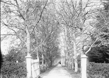 Stawell Historical Society Inc
Photograph, “The Sycamores” Driveway entrance Gates
Entrance gates to “The Sycamores” Driveway. A show place on Concongella from mid 1860's. "The Sychmores" where William Osmand lived. Osmand's "Sycamores" was in a secluded block of the eastern side of the creek along which was planted pine and cypress trees. He built a comfortable house and line the carriage way with Sycamores. Osmand was on the of the men who made money in the Stawell reefs mines. "The Sycamores" has been owned by the West family since c 1920. Black & white photograph (2 copies) of an entrance gateway with an avenue of deciduous trees.concongella -
 Canterbury History Group
Document - Thematic Environmental History, Built Heritage, 1/05/2012
Thematic Environmental Heritage. Final document produced, after community consultation, for the City of Boroondara by Built Heritage242 pages city of boroondara, back yards, canterbury, churches, cottages, dairies, danks family, elgar survey, exploration, frognall, goldings boot factory, maling road, malone's hotel, maps, masonic lodges, national parks, native plants, outer circle railway line, police stations, post offices, railways, rochester road, schools, shrublands, soldiers memorial hall, sport, telephone exchanges, theatres, transport, wildlife, canterbury road, land subdivisions, parks and reserves -
 Eltham District Historical Society Inc
Photograph - Digital Photograph, Alan King, Blue Lake, Plenty Gorge Park, 2008
A quarry was transformed into the Blue Lake. Published: Nillumbik Now and Then / Marguerite Marshall 2008; photographs Alan King with Marguerite Marshall.; p179 The dramatic steep-sided Plenty Gorge lies along the divide of two geological areas, and separates the Nillumbik Shire and the City of Whittlesea. On the Nillumbik side are undulating hills and sedimentary rock, and in Whittlesea, lies a basalt plain formed by volcanic action up to two million years ago. This provides the Plenty Gorge Park with diverse vegetation and habitats, making it one of Greater Melbourne’s most important refuges for threatened and significant species. The park, established in 1986, consists of around 1350 hectares, and extends 11 kilometres along the Plenty River, from Greensborough to Mernda. It provides a wildlife corridor for around 500 native plant and 280 animal species. The area’s plentiful food and water attracted the Wurundjeri Aboriginal people and then European settlers. By 1837 squatters had claimed large runs of land for their sheep and cattle. The Plenty Valley was among the first in the Port Phillip District to be settled - mainly in the less heavily timbered west - and was proclaimed a settled district in 1841.But by the late 1880s, the settlers’ extensive land clearing for animal grazing, then agriculture, depleted the Wurundjeri’s traditional food sources, which helped to drive them away. Many Wurundjeri artefacts remain (now government protected), and so far 57 sites have been identified in the park, including scarred trees, burial areas and stone artefacts. Pioneer life could be very hard because of isolation, flooding, bushfires and bushrangers. Following the Black Thursday bushfires of 1851, basalt was quarried to build more fire-resistant homes. Gold discoveries in the early 1850s swelled the population, particularly around Smugglers Gully; but food production made more of an impact. In the late 1850s wheat production supplanted grazing. In the 1860s the government made small holdings available to poorer settlers. These had the greatest effect on the district, particularly in Doreen and Yarrambat, where orchards were established from the 1880s to 1914. Links with a prominent early family are the remains of Stuchbery Farm, by the river’s edge bounded by Smugglers Gully to the north and La Trobe Road, Yarrambat, to the east. The Stuchberys moved to the valley in 1890, and the family still lives in the area. In 1890, Alfred and Ada first lived in a tent where four children were born, then Alfred built the house and outbuildings around 1896. They planted an orchard, then a market garden, and developed a dairy. The family belonged to the local Methodist and tennis communities. Their grandson Walter, opened the Flying Scotsman Model Railway Museum in Yarrambat, which his widow, Vi, continues to run. Wal was also the Yarrambat CFA Captain for 22 years until 1987. Walter sold 24 hectares in 1976 for development - now Vista Court - and in 1990, the remaining 22.6 hectares for the park. Remaining are an early stone dairy and remnants of a stone barn, a pig sty and a well. Until it was destroyed by fire in 2003, a slab hut stood on the Happy Hollow Farm site, at the southern end of the park. The hut is thought to have been built in the Depression around 1893. This was a rare and late example of a slab hut with a domestic orchard close to Melbourne. Emmet Watmough and his family first occupied the hut, followed by a succession of families, until the Bell family bought it around 1948. There they led a subsistence lifestyle for 50 years, despite encroaching Melbourne suburbia. The Yellow Gum Recreation Area includes the Blue Lake, coloured turquoise at certain times of the year. Following the 1957 bushfires, this area was quarried by Reid Quarries Pty Ltd for Melbourne’s first skyscrapers, then by Boral Australia. However in the early 1970s water began seeping into the quarry forming the Blue Lake and the quarry was closed. The State Government bought the site in 1997 and opened it as a park in 1999.This collection of almost 130 photos about places and people within the Shire of Nillumbik, an urban and rural municipality in Melbourne's north, contributes to an understanding of the history of the Shire. Published in 2008 immediately prior to the Black Saturday bushfires of February 7, 2009, it documents sites that were impacted, and in some cases destroyed by the fires. It includes photographs taken especially for the publication, creating a unique time capsule representing the Shire in the early 21st century. It remains the most recent comprehenesive publication devoted to the Shire's history connecting local residents to the past. nillumbik now and then (marshall-king) collection, blue lake, plenty gorge park -
 Eltham District Historical Society Inc
Photograph - Digital Photograph, Marguerite Marshall, Stuchbery Farm dairy, 14 March 2008
Stuchbery Farm was situated on the Plenty River bounded by Smugglers Gully to the north and La trobe Road, Yarrambat, to the east. Alan and Ada Stutchbery moved to the valley in 1890, first living in a tent where four children were born. Alfred built a home and outbuildings around 1896. They planted an orchard, then a market garden and developed a dairy. Published: Nillumbik Now and Then / Marguerite Marshall 2008; photographs Alan King with Marguerite Marshall.; p179 The dramatic steep-sided Plenty Gorge lies along the divide of two geological areas, and separates the Nillumbik Shire and the City of Whittlesea. On the Nillumbik side are undulating hills and sedimentary rock, and in Whittlesea, lies a basalt plain formed by volcanic action up to two million years ago. This provides the Plenty Gorge Park with diverse vegetation and habitats, making it one of Greater Melbourne’s most important refuges for threatened and significant species. The park, established in 1986, consists of around 1350 hectares, and extends 11 kilometres along the Plenty River, from Greensborough to Mernda. It provides a wildlife corridor for around 500 native plant and 280 animal species. The area’s plentiful food and water attracted the Wurundjeri Aboriginal people and then European settlers. By 1837 squatters had claimed large runs of land for their sheep and cattle. The Plenty Valley was among the first in the Port Phillip District to be settled - mainly in the less heavily timbered west - and was proclaimed a settled district in 1841. But by the late 1880s, the settlers’ extensive land clearing for animal grazing, then agriculture, depleted the Wurundjeri’s traditional food sources, which helped to drive them away. Many Wurundjeri artefacts remain (now government protected), and so far 57 sites have been identified in the park, including scarred trees, burial areas and stone artefacts. Pioneer life could be very hard because of isolation, flooding, bushfires and bushrangers. Following the Black Thursday bushfires of 1851, basalt was quarried to build more fire-resistant homes. Gold discoveries in the early 1850s swelled the population, particularly around Smugglers Gully; but food production made more of an impact. In the late 1850s wheat production supplanted grazing. In the 1860s the government made small holdings available to poorer settlers. These had the greatest effect on the district, particularly in Doreen and Yarrambat, where orchards were established from the 1880s to 1914. Links with a prominent early family are the remains of Stuchbery Farm, by the river’s edge bounded by Smugglers Gully to the north and La Trobe Road, Yarrambat, to the east. The Stuchberys moved to the valley in 1890, and the family still lives in the area. In 1890, Alfred and Ada first lived in a tent where four children were born, then Alfred built the house and outbuildings around 1896. They planted an orchard, then a market garden, and developed a dairy. The family belonged to the local Methodist and tennis communities. Their grandson Walter, opened the Flying Scotsman Model Railway Museum in Yarrambat, which his widow, Vi, continues to run. Wal was also the Yarrambat CFA Captain for 22 years until 1987. Walter sold 24 hectares in 1976 for development - now Vista Court - and in 1990, the remaining 22.6 hectares for the park. Remaining are an early stone dairy and remnants of a stone barn, a pig sty and a well. Until it was destroyed by fire in 2003, a slab hut stood on the Happy Hollow Farm site, at the southern end of the park. The hut is thought to have been built in the Depression around 1893. This was a rare and late example of a slab hut with a domestic orchard close to Melbourne. Emmet Watmough and his family first occupied the hut, followed by a succession of families, until the Bell family bought it around 1948. There they led a subsistence lifestyle for 50 years, despite encroaching Melbourne suburbia. The Yellow Gum Recreation Area includes the Blue Lake, coloured turquoise at certain times of the year. Following the 1957 bushfires, this area was quarried by Reid Quarries Pty Ltd for Melbourne’s first skyscrapers, then by Boral Australia. However in the early 1970s water began seeping into the quarry forming the Blue Lake and the quarry was closed. The State Government bought the site in 1997 and opened it as a park in 1999.This collection of almost 130 photos about places and people within the Shire of Nillumbik, an urban and rural municipality in Melbourne's north, contributes to an understanding of the history of the Shire. Published in 2008 immediately prior to the Black Saturday bushfires of February 7, 2009, it documents sites that were impacted, and in some cases destroyed by the fires. It includes photographs taken especially for the publication, creating a unique time capsule representing the Shire in the early 21st century. It remains the most recent comprehenesive publication devoted to the Shire's history connecting local residents to the past. nillumbik now and then (marshall-king) collection, ada stuchbery, alan stuchbery, dairy, stuchbery farm, farm buildings, yarrambat, plenty gorge park