Showing 393 items
matching quarters
-
 Kiewa Valley Historical Society
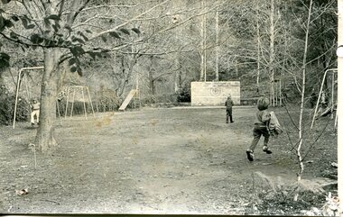
Photograph – black and white photograph of children playing in the school yard at Bogong Village Primary School, Circa late 1960s to early 1970’s
The early forties saw rapid growth of Bogong Village, with single and married men’s quarters, workshops, mess huts and administrative offices. The facilities necessary for communal living were quickly in place- a post office, police station, co-op store, medical centre, community hall/theatre, tennis courts and school. Bogong Primary School opened in 1941 to provide an education for the families of employees of the State Electricity Commission of Victoria. The school had up to date equipment and received glowing reports from school inspectors. It closed circa 1970.The Bogong State School was opened for the children of S.E.C.V. workers who lived in Bogong in a remote part of north east Victoria. The nearest school would have been 14 miles away and over mountain roads subject to heavy construction traffic and extremes of climatic conditionsBlack and white photograph of a group of 6 children playing on play equipment in the schoolyard at Bogong Primary School. The area is enclosed by tall trees in a bush-like settingbogong state school; secv; kiewa hydro electric scheme; -
 Otway Districts Historical Society
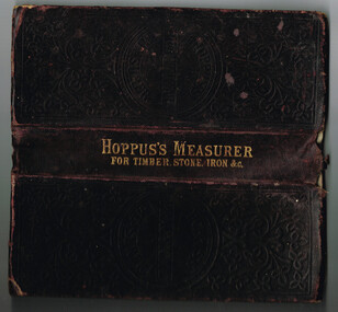
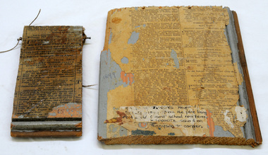
Book, Hoppus's Practical Measurer
Manufactured by E. Hoppus the Hoppus's Practical Measurer, or measuring made easy by a new set of tables which show by looking the solid content of any piece of timber, stone, etc, either square, round or unequally sided, and the value at any price of cubic feet. The book also gives the superficial comtent of boards, glass, painting and plastering with explanations of the uses and applications of the tables. The contents are given in feet, inches, quarters and twelfth parts of an inch. It includes the measurment of timber by several dimensions together with tables showing the weight of iron by measure.Hoppus's Practical Measurer; or, Measuring made easy by a new set of tables, which show, at sight, the solid content of any piece of timber, stone, &c. W. Nicholson & Sons; London; nd. 238 p. Hard cover.e. hoppus; measurment; timber; stone; boards; glass; painting; plastering, iron; -
 Parks Victoria - Gabo Island Lightstation
Insulator
Modern communication technologyarrived on gabo Island with the construction of the telegraph line from Eden to Gabo Island in 1870. The insulator is associated with the telegraph station. Used at the H.F Radio Beacon. The items of telegraphic equipment comprise a number of ceramic and glass insulators of varying age and type. In addition to insulators, there is a telephone insulator bracket made of metal with wooden pins. It was once attached to the top of a steel pole and some of these remain in situ along the former telegraph line (0044). Telegraphic communication commenced at the Gabo Lightstation in 1870, just eight years after the lightstation opened. The line from Sydney reached Eden, NSW by 1868 and was then extended to Gabo with the costs shared equally by NSW and Victoria. It was initially carried on posts across the sea to the island but was changed to a line along the seabed after the posts were washed away. The first telegraph office was a timber building on east side of the assistants’ quarters. In 1887 a new concrete telegraph office was built which included quarters for the operator, with Victoria and NSW sharing the construction costs. The 1992 CMP identified remnants of the line from its various phases of operation,and these were seen in 2016. Other ceramic insulators in the collection are associated with lines supported on utility poles for the transmission of high voltage electricity. The various insulators have second level significance for their historic value and provenanceFour armed cross shaped insulator with two holes through diagonally opposite sections. It is ceramic with a clear glaze. -
 Flagstaff Hill Maritime Museum and Village
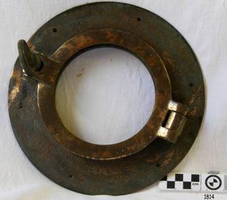
Functional object - Porthole, First half of the 20th century
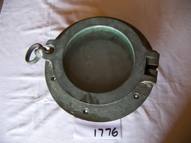
A porthole, sometimes called bull's-eye window or bull's-eye, is a generally circular window used on the hull of ships to admit light and air. Though the term is of maritime origin, it is also used to describe round windows on armoured vehicles and aircraft. On a ship, the function of a porthole, when open, is to permit light and fresh air to enter the dark and often damp below-deck quarters of the vessel. It also affords below-deck occupants a limited view to the outside world. When closed, the porthole provides a strong water-tight, weather-tight and sometimes light-tight barrier.The porthole is an example of a ships fittings and is not associated with an historical event, person or place, provenance is unable to be determined at this time and the item is believed to have been made in the first half of the 20th century.Porthole and cover, brass and glass with one screw dog fitting to secure hinged cover. Marked 6" on hinge and ringflagstaff hill, warrnambool, maritime museum, maritime village, great ocean road, shipwreck coast, porthole, ship fitting, ship window -
 Flagstaff Hill Maritime Museum and Village
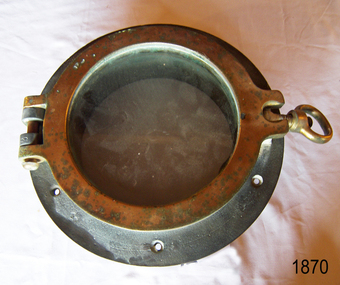
Functional object - Porthole, First half of the 20th century
A porthole, sometimes called bull's-eye window or bull's-eye, is a generally circular window used on the hull of ships to admit light and air. Though the term is of maritime origin, it is also used to describe round windows on armoured vehicles and aircraft. On a ship, the function of a porthole, when open, is to permit light and fresh air to enter the dark and often damp below-deck quarters of the vessel. It also affords below-deck occupants a limited view to the outside world. When closed, the porthole provides a strong water-tight, weather-tight and sometimes light-tight barrier.The porthole is an example of a ships fittings and is not associated with an historical event, person or place, provenance is unable to be determined at this time and the item is believed to have been made in the first half of the 20th century.Porthole and cover, brass and no glass with screw dog to secure hinged cover.Marked 6" on hinge and ringflagstaff hill, warrnambool, shipwrecked-coast, flagstaff-hill, flagstaff-hill-maritime-museum, maritime-museum, shipwreck-coast, flagstaff-hill-maritime-village, porthole, marine window -
 Flagstaff Hill Maritime Museum and Village
Functional object - Porthole, First half of the 20th century
A porthole, sometimes called bull's-eye window or bull's-eye, is a generally circular window used on the hull of ships to admit light and air. Though the term is of maritime origin, it is also used to describe round windows on armoured vehicles and aircraft. On a ship, the function of a porthole, when open, is to permit light and fresh air to enter the dark and often damp below-deck quarters of the vessel. It also affords below-deck occupants a limited view to the outside world. When closed, the porthole provides a strong water-tight, weather-tight and sometimes light-tight barrier.The porthole is an example of a ships fittings and is not associated with an historical event, person or place, provenance is unable to be determined at this time and the item is believed to have been made in the first half of the 20th century.Porthole and cover, brass and glass with 1 screw dog to secure hinged cover. Marked 6" on ringflagstaff hill, warrnambool, shipwrecked-coast, flagstaff-hill, flagstaff-hill-maritime-museum, maritime-museum, shipwreck-coast, flagstaff-hill-maritime-village, porthole -
 Parks Victoria - Gabo Island Lightstation
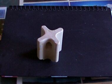
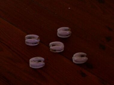
Insulators
Modern communications technology arrived on Gabo Island with the construction of the telegraph line from Eden to Gabo Island in 1870. This type of insulator was usually used with radio antennae wires, telegraph and radio antennae equipment. The items of telegraphic equipment comprise a number of ceramic and glass insulators of varying age and type. Five, knuckle-shaped white glazed ceramic examples are associated with radio antennae wires. In addition to insulators, there is a telephone insulator bracket made of metal with wooden pins. It was once attached to the top of a steel pole and some of these remain in situ along the former telegraph line. Telegraphic communication commenced at the Gabo Lightstation in 1870, just eight years after the lightstation opened. The line from Sydney reached Eden, NSW by 1868 and was then extended to Gabo with the costs shared equally by NSW and Victoria. It was initially carried on posts across the sea to the island but was changed to a line along the seabed after the posts were washed away. The first telegraph office was a timber building on east side of the assistants’ quarters. In 1887 a new concrete telegraph office was built which included quarters for the operator, with Victoria and NSW sharing the construction costs. The 1992 CMP identified remnants of the line from its various phases of operation, and these can still be seen in 2016. Other ceramic insulators in the collection are associated with lines supported on utility poles for the transmission of high voltage electricity. .The various insulators have second level significance for their historic value and provenanceFive white glazed ceramic insulators. Knuckle bone sized, oval shaped with one opening at either end. All five are the same. -
 Parks Victoria - Gabo Island Lightstation
Insulators
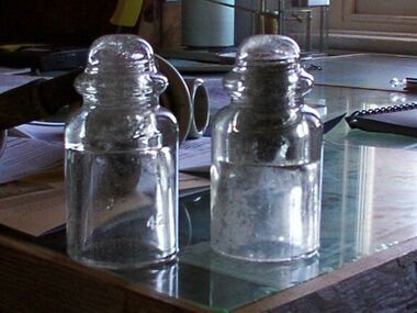
Modern communication tecnology arrived on Gabo Island with the construction of the telegraph line from Eden to Gabo Island in 1870. These and other cylindricial insulators were associated with the original 1870 copper wire telegraph line and later the P.M.G. line. The items of telegraphic equipment comprise a number of ceramic and glass insulators of varying age and type. Two bell-shaped insulators are made of clear glass, one with remains of wooden dowel inside. In addition to insulators, there is a telephone insulator bracket made of metal with wooden pins. It was once attached to the top of a steel pole and some of theseremain in situ along the former telegraph line. Telegraphic communication commenced at the Gabo Lightstation in 1870, just eight years after the lightstation opened.The line from Sydney reached Eden, NSW by 1868 and was then extended to Gabo with the costs shared equally by NSW and Victoria. It was initially carried on posts across the sea to the island but was changed to a line along the seabed after the posts were washed away. The first telegraph office was a timber building on east side of the assistants’ quarters. In 1887 a new concrete telegraph office was built which included quarters for the operator, with Victoria and NSW sharing the construction costs. The 1992 CMP identified remnants of the line from its various phases of operation,231 and these can still be seen in 2016. Other ceramic insulators in the collection are associated with lines supported on utility poles for the transmission of high voltage electricity. The various insulators have second level significance for their historic value and provenance1. Clear glass insulator. Cyndrical bottle shape with smaller dome -like knob on top. Hollow with inscription on lower edge. Has remains of wooden dowell inside. 2.Clear glass insulator. Cyndrical bottle shape with smaller dome -like knob on top. Hollow with inscription on lower edge.Around lower edge on opposite sides,"C.C / 42" -
 Kew Historical Society Inc
Photograph, J E & B L Rogers, Stables, 'Roseneath', Pakington Street, c.1959
This work forms part of the collection assembled by the historian Dorothy Rogers, that was donated to the Kew Historical Society by her son John Rogers in 2015. The manuscripts, photographs, maps, and documents were sourced by her from both family and local collections or produced as references for her print publications. Many were directly used by Rogers in writing ‘Lovely Old Homes of Kew’ (1961) and 'A History of Kew' (1973), or the numerous articles on local history that she produced for suburban newspapers. Most of the photographs in the collection include detailed annotations in her hand.The Rogers Collection provides a comprehensive insight into the working habits of a historian in the 1960s and 1970s. Together it forms the largest privately-donated collection within the archives of the Kew Historical Society.'Roseneath' was constructed in stages in the I850s by John Ambrose Kitchen, a soap-maker. In 1870 the brick house received an N.A.V. of £60 while in 1885 it was purchased by Edward John Dunn, a geologist. A new wing was built at the right side of the house and several rooms as well as the coach house, loft and groom's quarters were added. In 1903, during Dunn's ownership, the property was described as having eight roorns. The garden is recorded as having been designed by Baron von Mueller who was the Government Botanist from 1853. Source: City of Kew Urban Conservation Study, 1988"32"historic houses -- kew (vic.), roseneath -- pakington street -- kew (vic.) -
 Bendigo Historical Society Inc.
Photograph - T C WATTS & SON COLLECTION: VIOLET STREET BENDIGO, 1929
Black and white photographs (2) , mounted on rectangular grey board. House, rendered with porch with decorative gable, slate roof, 2 chimneys, established garden with rock edging. Written on back of photo board ' Geo. Every, Violet Street, 875 pounds' On back of record date stamp 27 April 1929. Note attached to record ' this house was originally kitchen and staff quarters of Alexander Bayne's house "Montanvert" ( from Myrtle Street to Violet). Address of Alexander Bayne's former house, of which this house was formerly part of, is 84 Violet Street, Bendigo.Frank A. Jeffree, Bendigoresidential, alexander bayne, violet street, bendigo, george every -
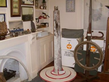 Parks Victoria - Gabo Island Lightstation
Flagpole
Found on a wood heap near the tractor shed. Only the top portion remains. The former fixture is the tapered top section of the wooden flagpole that formerly stood at the front of the head keepers quarters. There is a hole with attached metal pulley near the top which allowed for hoisting the flags to signal passing ships. Signal flags were hoisted on the flagpole and were used to communicate with passing shipping. Messages were then relayed by the overland telegraph line to Eden. Remains of black paint provide evidence of the blackout measures implemented during World War 11. The pole is currently fixed to a stand to allow for its display.The pole remnant has second level significance for its historic value and provenance.Top sction of a flagpole. At the top it is tapered and fashioned into a square section. Near the top of the pole is a hole with a metal pulley inside. There is black and white paint flaking off leaving bare wood. -
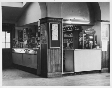
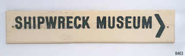 Flagstaff Hill Maritime Museum and Village
Sign - Shipwreck Museum sign, Flagstaff Hill Historic Park Planning Board, Shipwreck Museum, ca. 1975
This sign is painted on both sides. It was attached to the bluestone wall on the western wing of the Lighthouse Keeper's Quarters, the Assistant Keeper's Quarters, at Flagstaff Hill Maritime Museum and Village for almost 50 years. The Complex was opened to the public on December 11, 1975, and officially opened by Victorian Premier Sir Rupert Hamer on July 8th, 1977. The sign's reverse side reads "Loch Ard Peacock & Museum". The three rooms had displays behind glass showing various ships' fittings, cargo and personal belongings recovered from significant shipwrecks along the southwest coast of Victoria. There was also a display of information about the mysterious Mahogany Ship or Ancient Wreck. The shipwreck artefacts were recovered by local divers in the 1960s and early 1970s. Also on display was the famous Loch Ard Peacock, created in 1873, survived the shipwreck in 1878, was purchased by Flagstaff Hill in 1975 and announced as being on display in The Standard of September 15, 1975. In about 1984 the other side of the sign was painted "SHIPWRECK MUSEUM" and re-displayed on the building. The Loch Ard Peacock was by that time on display in the Entrance building; plans were underway on August 31st 1984 to build a Hall for its unique display. In February 2023 the sign was removed from the building, which was undergoing restoration and preparation for use as a new Temporary Exhibition space. The Loch Ard Peacock continued its journey around the Village; it was moved from the Entrance to the Village's newly completed Public Hal in 1986. It also spent a short time in the Stella Maris Tea Rooms. This was likely around 1998, when the Common School had moved from the Chartroom building to what had been the Public Hall. The Loch Ard Peacock was once again moved in around 2001, this time to be the central attraction and meeting place in the Great Circle Gallery, which opened on December 31st 2002. The sign continued to be displayed on the western wing of the Lighthouse Keeper's Quarters until February 2023. This wing has now been restored and re-fitted to become a facility for short-term exhibitions. A section of the original internal wall frame and wallpaper that couldn’t be kept in the building due to preservation issues have been saved and become sort of the Flagstaff Hill Collection. The sign has guided the visitors of Flagstaff Hill Maritime Museum and Village to the exhibits of artefacts from historic and significant shipwrecks. It has connected the current generations to the people and objects of the past, leading to a better understanding of our Colonial history.Sign, wooden, rectangular, with a hole through each short side. The front and reverse have different painted text. Cream paint for the background colour, green paint for the lettering, and the reverse has a white painted border. The front has an arrow painted on the right-hand side. The sign was used at Flagstaff Hill since its opening.Text on front "SHIPWRECK MUSEUM >" Text on back "LOCH ARD PEACOCK / & MUSEUM"flagstaff hill maritime museum and village, warrnambool, great ocean road, shipwreck coast, sign, building sign, shipwreck museum, loch ard peacock & museum, flagstaff hill history, assistant lighthouse keeper's cottage, assistand lighthouse keeper's quarters, public hall, common school -
![View of a Victorian Sheep Station / [by] Nicholas Caire, circa 1876](/media/collectors/550653872162f11fb04854aa/items/577b58dad0cdd10948cfdc7b/item-media/577b5942d0cdd10948d01fbf/item-fit-380x285.jpg) Kew Historical Society Inc
Kew Historical Society IncPhotograph, View of a Victorian Sheep Station, c.1876
Nicholas Caire was born on Guernsey in the Channel Islands in 1837. He arrived in Adelaide with his parents in about 1860. In 1867, following photographic journeys in Gippsland, he opened a studio in Adelaide. From 1870 to 1876 he lived and worked in Talbot in Central Victoria. In 1876 he purchased T. F. Chuck's studios in the Royal Arcade Melbourne. In 1885, following the introduction of dry plate photography, he began a series of landscape series, which were commercially successful. As a photographer, he travelled extensively through Victoria, photographing places few of his contemporaries had previously seen. He died in 1918. Reference: Jack Cato, 'Caire, Nicholas John (1837–1918)', Australian Dictionary of Biography.An original, rare photograph from the series 'Views of Victoria: General Series' by the photographer, Nicholas Caire (1837-1918). The series of 60 photographs that comprise the series was issued c. 1876 and reinforced a neo-Romantic view of the Australian landscape to which a growing nationalist movement would respond. Nicholas Caire was active as a photographer in Australia from 1858 until his death in 1918. His vision of the Australian bush and pioneer life had a counterpart in the works of Henry Lawson and other nationalist poets, authors and painters.Views of Victoria (General Series) No.29 / ‘View of a Victorian Sheep Station’ / Albumen silver photograph mounted on boardOn Reverse: ‘The present illustration is characteristic of a Squatter’s Station in Victoria, and is situated near Elphinstone. In the centre of the picture may be seen the Squatter’s residence or head-quarters surrounded by sheds and out-houses, and in the foreground is a flock of sheep in charge of a lad. Of late years it has become the practice to erect fences around the Australian Sheep Stations, which necessitates only the services of a boundary rider, and dispenses with those of a number of shepherds.’nicholas caire (1837-1918), landscape photography -
 Mission to Seafarers Victoria
Photograph - Photograph, Black and white, Melbourne Harbour Trust, c. 1963
The canteen is part of the Mission to Seafarers building that has catered to visiting seafarers since 1917. The canteen is operated by the Flying Angel Club, which offered services to seafarers including food, drink and souvenirs from the canteen and events held in the main hall which invloved the use of the canteen. The Ladies Harbor Lights Guild also used the canteen facilities for functions and fundraisers held at the Mission to Seafarers. One of the flyer in Chinese helps dating the photograph between 1963-66 when Padre Wong was chaplain at the Mission.Historical record of the Mission to Seafarers canteen post-1963. This is an example of the contemporaneous use of the canteen as primarily a supply shop and in a comparative fashion reveals some of the overall changes at the Mission.A white-bordered, black and white photograph of the Mission to Seafarers Canteen. From the left hand side of the photograph the image portrays an external doorway with six glass windows, emitting light from behind. This leads to the dipslay cabinet and bench of the canteen which is reflecting light from the windowed door. Central to the image is a pillar which is three-quarters wood paling starting from the floor, of which a map is displayed on one edge and a notice board on the remaining visible edge of the pillar. A bench is visible to the right side of the pillar and the far right side of the photograph, posters are hung on the wall. Purple stamp on central back of photograph. "Melbourne Harbor/Trust Photograph/Negative No......." photograph, canteen, tab, koalas, blackboard, archway, pennant, licensed-to-sell-postage-stamps, mission to seamen, mission to seafarers, melbourne, flying angel club, map, bar, milkshake machine, display case, fluorescent light, notice board, wains coting, postcards, milkshake, beverage, plastichrome, matches, razors, gillette, straw, melbourne harbour trust, melbourne harbor trust, donation tin, lighthouse -
 Bendigo Historical Society Inc.
Document - CONCERT, BENDIGO MUSICAL SOCIETY, 23 Oct, 1913
Concert, Bendigo Musical Society. Wednesday, 23 Oct., 1913. Artists: Misses Bolt, Miss Elise Chamberlain, Miss Myrtle Knight, Miss Phyllis Hannaford, Miss Dagmar Levy, Mrs. Mueller, Misses Chamberlain, Hannaford, Macoboy, Mayberry, and Penfold, Beryl Leggo, Miss Dorothy Penfold, Miss Muriel Boldt, Agnes McNair, Phyllis Hannaford, Misses Levy and Leggo. Program has been folded in quarters, is discoloured and has brown spots. 4 small tears on the right where it has been folded, top and bottom ones are 3mm, center one is 15mm.program, music, bendigo musical society, concert, bendigo musical society. wednesday, 23 oct., 1913. artists: misses bolt, miss elise chamberlain, miss myrtle knight, miss phyllis hannaford, miss dagmar levy, mrs. mueller, misses chamberlain, hannaford, macoboy, mayberry, and penfold, beryl leggo, miss dorothy penfold, miss muriel boldt, agnes mcnair, phyllis hannaford, misses levy and leggo. -
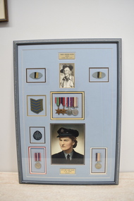 Dandenong/Cranbourne RSL Sub Branch
Photograph - Framed photographs with shoulder patches and Service Medals
Very historical significance. Robert was part of a group of 500 Servicemen captured as P.O.Ws.at Padang Sumatra. The POWs were accommodated in 6 long barracks buildings that ran side by side. They were behind an 8 foot high wall containing a parade ground, sports ground, Japanese Officers and guards quarters. The POWs were put to work on the infamous Sumatra Railway. Part of that group were: Richard Winston Annear WX13468. Alfred John Burgess WX15756. Clifford Dudley Squance WX16885. Arthur Melville Magill WX16886. Harold Mervyn Smith WX17448. Robin Roy Semple WX7532. Edward Mason Hopson WX9241. Cecil George Quinn WX9285.Large grey framed photographs with shoulder patches, service stripes and Service Medals. Photographs are of Robert Frederick Nelson VX8212 2/29th A.I.F and Betty Emily Louise Collins A.C.W 110082 W.A.A.F. Service Medals for Robert are The Pacific Star, 1939 - 45 Star, 1939 - 1945 War Medal and 1939 - 1945 Service Medal. Service Medals for Betty are 1939 - 1945 War Medal and 1939 - 1945 Service Medal. Engraved metal nameplates with names and Service numbers at top and bottom. -
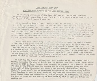 Melbourne Legacy
Document, Lord Somers Camp 1967. RW Anderson reports on the Lord Somers' Camp, 1967
An account of Big Camp 1967 by a junior legatee that attended. It was an impression of the camp by Rod Anderson from Brighton Grammar. It was a reprint from 'The Brighton Grammarian'. The boys took a special train from Flinders St station direct to Somers. It mentions the location of the camp on the shores of Westernport Bay and the tidal creek and wooden bridge. It has a centrally placed circular lawn with huts and slushies quarters and the main hall. The camp has it's own radio station - Radio Somers, plus a printing press and open air theatre. Was stapled to 01970 JL11 Why I founded the Somers Camp an article about Lord Somers published in 1933.A record of the camp at Somers in the words of a junior legatee that attended in 1967.Foolscap page x 2 of black type.Handwritten 'JL11/10' in black pen.camp, lord somers, lord somers camp -
 The Beechworth Burke Museum
Photograph, c1930
Taken on 25 October 1930, various houses with the Hume Dam under construction are depicted in the background. The construction of the Hume Dam took place from 1919 to 1936. At the time of construction, it was the second largest dam in the world. It was also one of the earliest civil projects developed after the Federation. Some of the Dam workers consisted of World War I veterans. Dam workers often settled their families in Mitta Junction Village and Wodonga. Archaeological surveys were completed by Austral Archaeology, which was done when the Department of Land & Water Conservation was doing work to improve Hume Dam. The archaeological report that came out of the survey recommended three sites of interest where archaeological excavation should be done: Camp Ganger’s Quarters, Stableman’s Quarters, and the Industrial Dump. The excavation uncovered artefacts. Mitta Mitta: Mitta Mitta is situated between Mount Welcome and Mount Misery. It is named after the river that explorers Hume and Hovell discovered in 1824. The town would eventually become a huge gold mining town. Mitta Mitta is called Midamodunga by the local Indigenous peoples Wodonga: Wodonga is situated on the Murray River and is part of North East Victoria. Hume and Hovell: Hamilton Hume (1979-1873) and William Hilton Hovell (1786-1875). W. H. Hovell was born in Norfolk England and Hume was born in Parramatta, New South Wales Hovell and Hume undertook an exploration journey in 1824 and thought they discovered a river, which turned out to be the Murray River. They returned home in 1825, but returned to the area in 1826 and discovered coal in the area. This photo is historically significant as it shows the Hume Dam under construction in 1930. The Dam was named after Hamilton Hume, who is an important historical figure for this area as he helped discover the area where resources were found.Sepia rectangular photograph printed unmountedReverse: 84-19-5 / 1997.3185/ Values & spillway. / When completed the wall / will be as high as the / scaffolding. [featuring trademark: kodak print]construction, houses, veterans, mitta junction village, hume dam, world war i, federation, wodonga, archaeological survey, excavation, austral archaeology, department of land & water conservation, camp ganger's quarter's, stableman's quarters, industrial dump, artefacts, mitta mitta, mount welcome, mount misery, murray river, hamilton hume, william hilton hovell, hume and hovell expedition -
 The Beechworth Burke Museum
Photograph, c1930
Taken on 25 October 1930, various houses with the Hume Dam under construction are depicted in the background. The construction of the Hume Dam took place from 1919 to 1936. At the time of construction, it was the second largest dam in the world. It was also one of the earliest civil projects developed after the Federation. Some of the Dam workers consisted of World War I veterans. Dam workers often settled their families in Mitta Junction Village and Wodonga. Archaeological surveys were completed by Austral Archaeology, which was done when the Department of Land & Water Conservation was doing work to improve Hume Dam. The archaeological report that came out of the survey recommended three sites of interest where archaeological excavation should be done: Camp Ganger’s Quarters, Stableman’s Quarters, and the Industrial Dump. The excavation uncovered artefacts. Mitta Mitta: Mitta Mitta is situated between Mount Welcome and Mount Misery. It is named after the river that explorers Hume and Hovell discovered in 1824. The town would eventually become a huge gold mining town. Mitta Mitta is called Midamodunga by the local Indigenous peoples Wodonga: Wodonga is situated on the Murray River and is part of North East Victoria. Hume and Hovell: Hamilton Hume (1979-1873) and William Hilton Hovell (1786-1875). W. H. Hovell was born in Norfolk England and Hume was born in Parramatta, New South Wales Hovell and Hume undertook an exploration journey in 1824 and thought they discovered a river, which turned out to be the Murray River. They returned home in 1825, but returned to the area in 1826 and discovered coal in the area.This photo is historically significant as it shows the Hume Dam under construction in 1930. The Dam was named after Hamilton Hume, who is an important historical figure for this area as he helped discover the area where resources were found.Sepia rectangular photograph printed unmountedReverse: 84-19-2/ 1997.3188/ These are the four / release valves they are / not always open (illegible) this / when closed the water flows / over the spillway. [featuring trademark: kodak print] photograph number: 354construction, houses, veterans, mitta junction village, hume dam, world war i, federation, wodonga, archaeological survey, excavation, austral archaeology, department of land & water conservation, camp ganger's quarter's, stableman's quarters, industrial dump, artefacts, mitta mitta, mount welcome, mount misery, murray river, hamilton hume, william hilton hovell, hume and hovell expedition -
 The Beechworth Burke Museum
Photograph, 25 October 1930
Taken on 25 October 1930, various houses with the Hume Dam under construction are depicted in the background. The construction of the Hume Dam took place from 1919 to 1936. At the time of construction, it was the second largest dam in the world. It was also one of the earliest civil projects developed after the Federation. Some of the Dam workers consisted of World War I veterans. Dam workers often settled their families in Mitta Junction Village and Wodonga. Archaeological surveys were completed by Austral Archaeology, which was done when the Department of Land & Water Conservation was doing work to improve Hume Dam. The archaeological report that came out of the survey recommended three sites of interest where archaeological excavation should be done: Camp Ganger’s Quarters, Stableman’s Quarters, and the Industrial Dump. The excavation uncovered artefacts. Mitta Mitta: Mitta Mitta is situated between Mount Welcome and Mount Misery. It is named after the river that explorers Hume and Hovell discovered in 1824. The town would eventually become a huge gold mining town. Mitta Mitta is called Midamodunga by the local Indigenous peoples Wodonga: Wodonga is situated on the Murray River and is part of North East Victoria. Hume and Hovell: Hamilton Hume (1979-1873) and William Hilton Hovell (1786-1875). W. H. Hovell was born in Norfolk England and Hume was born in Parramatta, New South Wales Hovell and Hume undertook an exploration journey in 1824 and thought they discovered a river, which turned out to be the Murray River. They returned home in 1825, but returned to the area in 1826 and discovered coal in the area.This photo is historically significant as it shows the Hume Dam under construction in 1930. The Dam was named after Hamilton Hume, who is an important historical figure for this area as he helped discover the area where resources were found.Sepia rectangular photograph printed unmountedReverse: 84-19-6/ 1997.3187/ The spillway [featuring trademark: kodak print] construction, houses, veterans, mitta junction village, hume dam, world war i, federation, wodonga, archaeological survey, excavation, austral archaeology, department of land & water conservation, camp ganger's quarter's, stableman's quarters, industrial dump, artefacts, mitta mitta, mount welcome, mount misery, murray river, hamilton hume, william hilton hovell, hume and hovell expedition -
 The Beechworth Burke Museum
Photograph, 25 October 1930
Taken on 25 October 1930, various houses with the Hume Dam under construction are depicted in the background. The construction of the Hume Dam took place from 1919 to 1936. At the time of construction, it was the second largest dam in the world. It was also one of the earliest civil projects developed after the Federation. Some of the Dam workers consisted of World War I veterans. Dam workers often settled their families in Mitta Junction Village and Wodonga. Archaeological surveys were completed by Austral Archaeology, which was done when the Department of Land & Water Conservation was doing work to improve Hume Dam. The archaeological report that came out of the survey recommended three sites of interest where archaeological excavation should be done: Camp Ganger’s Quarters, Stableman’s Quarters, and the Industrial Dump. The excavation uncovered artefacts. Mitta Mitta: Mitta Mitta is situated between Mount Welcome and Mount Misery. It is named after the river that explorers Hume and Hovell discovered in 1824. The town would eventually become a huge gold mining town. Mitta Mitta is called Midamodunga by the local Indigenous peoples Wodonga: Wodonga is situated on the Murray River and is part of North East Victoria. Hume and Hovell: Hamilton Hume (1979-1873) and William Hilton Hovell (1786-1875). W. H. Hovell was born in Norfolk England and Hume was born in Parramatta, New South Wales Hovell and Hume undertook an exploration journey in 1824 and thought they discovered a river, which turned out to be the Murray River. They returned home in 1825, but returned to the area in 1826 and discovered coal in the area.This photo is historically significant as it shows the Hume Dam under construction in 1930. The Dam was named after Hamilton Hume, who is an important historical figure for this area as he helped discover the area where resources were found.Black and white rectangular photograph printer unmountedReverse: 84-20-1/ 1997.3147construction, houses, veterans, mitta junction village, hume dam, world war i, federation, wodonga, archaeological survey, excavation, austral archaeology, department of land & water conservation, camp ganger's quarter's, stableman's quarters, industrial dump, artefacts, mitta mitta, mount welcome, mount misery, murray river, hamilton hume, william hilton hovell, hume and hovell expedition -
 The Beechworth Burke Museum
Photograph, 25 October 1930
Taken on 25 October 1930, various houses with the Hume Dam under construction are depicted in the background. The construction of the Hume Dam took place from 1919 to 1936. At the time of construction, it was the second largest dam in the world. It was also one of the earliest civil projects developed after the Federation. Some of the Dam workers consisted of World War I veterans. Dam workers often settled their families in Mitta Junction Village and Wodonga. Archaeological surveys were completed by Austral Archaeology, which was done when the Department of Land & Water Conservation was doing work to improve Hume Dam. The archaeological report that came out of the survey recommended three sites of interest where archaeological excavation should be done: Camp Ganger’s Quarters, Stableman’s Quarters, and the Industrial Dump. The excavation uncovered artefacts. Mitta Mitta: Mitta Mitta is situated between Mount Welcome and Mount Misery. It is named after the river that explorers Hume and Hovell discovered in 1824. The town would eventually become a huge gold mining town. Mitta Mitta is called Midamodunga by the local Indigenous peoples Wodonga: Wodonga is situated on the Murray River and is part of North East Victoria. Hume and Hovell: Hamilton Hume (1979-1873) and William Hilton Hovell (1786-1875). W. H. Hovell was born in Norfolk England and Hume was born in Parramatta, New South Wales Hovell and Hume undertook an exploration journey in 1824 and thought they discovered a river, which turned out to be the Murray River. They returned home in 1825, but returned to the area in 1826 and discovered coal in the area. This photo is historically significant as it shows the Hume Dam under construction in 1930. The Dam was named after Hamilton Hume, who is an important historical figure for this area as he helped discover the area where resources were found. Black and white rectangular photograph printer unmountedReverse: 1997.3145/ 84-20-2construction, houses, veterans, mitta junction village, hume dam, world war i, federation, wodonga, archaeological survey, excavation, austral archaeology, department of land & water conservation, camp ganger's quarter's, stableman's quarters, industrial dump, artefacts, mitta mitta, mount welcome, mount misery, murray river, hamilton hume, william hilton hovell, hume and hovell expedition -
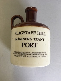 Warrnambool and District Historical Society Inc.
Flagon, R. L.Buller and Son Pty Ltd, Flagstaff Hill Maritime Village, 1970s
This flagon which once contained 750 ml. of tawny port was sold at Flagstaff Hill Maritime Village in Warrnambool in the 1970s and perhaps the 1980s as a souvenir of the village and Warrnambool. Flagstaff Hill Maritime Village was opened in 1975 and is a re-created 19th century village and port built in the area of a Warrnambool historic precinct containing several original features from the 19th century. These include two operating lighthouses, lighthouse keepers’ quarters, chart room and a fortifications area with two cannons. As the village is a re-created port and includes a hotel called the Steam Packet Inn, the sale of a souvenir flagon of tawny port was most appropriate. Flagstaff Hill Maritime Village and Museum still operate today. This flagon is retained as an example of the souvenirs sold in Warrnambool some years ago to tourists visiting Warrnambool and Flagstaff Hill Maritime Village. This is a ceramic flagon with a cream body and a brown top and handle. The printing on the flagon is black and the flagon also has black printing of the logo of Flagstaff Hill Maritime Village. The flagon has no stopper.‘Flagstaff Hill Mariner’s Tawny Port’flagstaff hill maritime museum, warrnambool -
 Orbost & District Historical Society
lining board, 1899
These items are from the Heyfield estate in 1899 from the pine lining of the old Orbost School residence which was opposite the school on the corner of Tennyson Street. The Orbost State School opened on 19th of March 1886 .The school had first operated temporarily in a leased building, and on a half-time basis with SS2745 Jarrahmond. The first head teacher was HT Campbell Mackay. However he remained in charge only until 12th of May 1886. The second HT, John Rowe, served until 1908. On 30th of June 1887, a portable room was provided; it being brought to the area by schooner. The school then had accommodation for 30 pupils; the teacher's welfare was considered because quarters of two rooms were attached.This item is part of the history of education in Orbost.Two pieces of pine wood lining boards with newspaper glued on to a blue painted background. 715.1 is the larger if the two pieces. On the larger piece is a tattered label with a hand-written description of the history of the board. The smaller piece has a nail on each side at the top with a piece of string tied to each ( for hanging). orbost-school education-orbost -
Glenelg Shire Council Cultural Collection
Photograph - Sheet of 12 contact prints - Various historic Portland buildings and Landmarks, c. 1970
Sheet of 12 contact prints of rephotographed photographs. Identifying numbers 5724 a, b, c, d, e, f, g, h, i, j, k, l (a) First jetty and immigration depot (b) National School (c) Observatory Hill (d) 'Kenley" Res. George Crouch, First Post Master (e) Old Library (f) Union (ANZ) Bank (g) Lighthouse and Keepers Cottage (h) 'Blainslie' (i) View from Whalers Bluff over Bay (j) Percy Street, view from Henty Street (k) Portland Jail (l) Flagstaff and Light Keepers quartersFront: (a) Henty Beach (b) Portland State School (c) Old Library (f) ANZ Bank (i) View of Whalers Point (k) Portland Jail on Observatory Hill -
Glenelg Shire Council Cultural Collection
Photograph - Sheet of 12 contact prints - Various historic Portland buildings and Landmarks, c. 1970
Sheet of 12 contact prints of rephotographed photographs. Identifying number 5717 a, b, c, d, e, f, g, h, i, j, k, l (a) Nun's Beach with boats (b) 3rd Baths (c) Percy Street West, view from Henty Street (d) Percy Street, west, further along Street (e) Habrour from Whalers Bluff (f) Portland Gaol (g) Flagstaff and Lightkeepers Quarters, Observatory Hill (h) Claremont (i) First Portland Post Office building (j) Res Abraham Barrett, baker (k) Warehouses Trangmar & Crouch (l) Union Bank -
 Ballarat Clarendon College
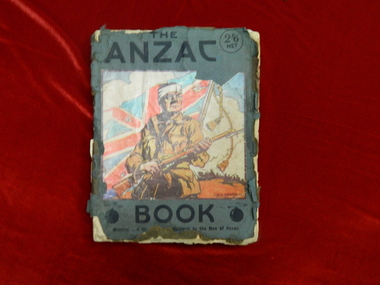
Albert Telfer White (1918) collection
Significant items relating to Albert Telfer White who entered Ballarat College April 1912 and left December 1918. Albert was born 29 June 1897 at his home 'Ashford Vale" farm, Cuthbert's Road, Cardigan. Albert, a second generation Australian, was the fourth son and sixth of eleven children born to dairy farmer John White and his wife Elizabeth, nee Douglas. Albert attended Bunker's Hill State School prior to enrolling at Ballarat College. After College he obtained employment with the engineering firm Ronaldson and Tippett in Ballarat. Following his eighteenth birthday Albert enlisted in the AIF in Ballarat with the rank of Private, No 2012. He embarked for the Middle East with 23rd Battalion on 26 August 1915 and was 'taken on strength at the Gallipoli Peninsular 25 October 1915". On 10 January 1916 Albert was posted to Alexandria, Egypt and during this time he was able to meet with his aunt Rose Douglas, an Australian Army Nursing Sister. This was a great comfort to his family. Albert was sent to France 19 March 1916 and transferred to the 22nd Battalion. He was mentioned in dispatches for 'good and gallant conduct' 5 August (1917?). Albert was hospitalised 30 March 1918, rejoined 22nd Battalion 3 June 1918, wounded in action 3 October 1918 but died of wounds at Rouen 10 October 1918. news of his death was received by his family n Australia just prior to the armistice. Albert Telfer White's sacrifice is commemorated at Ballarat College, Avenue of Honour Ballarat (Tree 1214), Ballarat Shire Honour Avenue Learmonth (Tree 163) and the Australian War Memorial Canberra. (These notes provided by family November 2016)Collections of items including: Bayonet, Carl Eickhorn, Solingen, (29.A.159 engraved on handle) Trench shovel The ANZAC book 1916 (flyleaf inscribed: No 2012 / Pte A T White / H Quarters / 22nd Battalion / 6th Inf Brigade / France) Gallipoli medal with documentation First World War Mothers’ and Widows’ Badge Next of Kin Memorial Plaque (Death Penny) and accompanying letter from King George V Imperial War Graves Commission documentation and photograph Australia Graves Services In Memory card and photograph Documentation relating to Australian War Memorial Roll of Honour, Learmonth Memorial Wall, Ballarat and Learmonth Avenues of Honours Documentation from the Australian Army Records office Documentation relating to Military Medal, 1914/15 Star, British War Medal and Victory Medal (whereabouts unknown, November 2016) Portraiture of Albert Telfer White as a child, as a young adult (civilian dress), in full kit (A I E F formal), and at camp 1915 Portraiture of sisters Cis, Addie, Bessie, Evelyn (with personal inscriptions) Four postcards (one with letter from Albert ‘at sea’ to his mother - undated) Death notice (unreferenced newspaper clipping) Biographical and family relationship details Photocopy of The White Family 1906 showing (standing) Adeline, Leslie, Harold (father), Muriel (mother), William; (seated) Albert, John (Grandfather), Elizabeth, Allan, Elizabeth (Grandmother), Evelyn (baby) and Benjamin The ANZAC book 1916 (flyleaf inscribed: No 2012 / Pte A T White / H Quarters / 22nd Battalion / 6th Inf Brigade / France) Gallipoli medal: engraved on reverse: A T WHITE Embossed lettering on death penny: ALBERT TELFER WHITE Handwritten on reverse of portraits: Lovingly yours / Cis / 21/11/17; your / loving sister / Addie; your loving / sister / Evelyn; Yours lovingly / Bessie Handwritten on back of postcard of ship H M A T 'Anchisis' 14.3.16: Dear Mother, I am sending you a card / of the boat we are on. Our deck is right / on the back. I have marked it with an X. / We are not allowed to put the date on or / where we are. I am sitting on the deck now / holding the card in my hand so it is hard / to write. We are together yet haven't been / separated Bill, Matt and myself. Haven't / had anything to do. I will write a couple / of letters now. Albert Handwritten on back of postcard photograph of Albert at camp: 30th September 1915 / Dear Mother / There is a studio at the / camp so Matt and I got our Photos / taken yesterday morning, & got them/ this morning. I am sending / Ciss one of Matt.albert-telfer-white, ballarat college, world-war-one, avenue-of-honour -
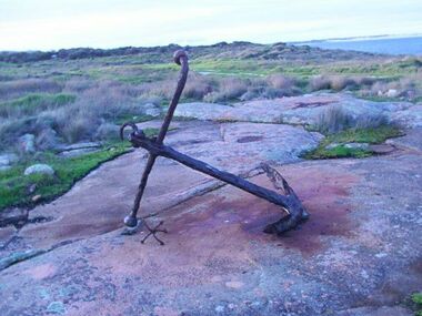 Parks Victoria - Gabo Island Lightstation
Anchor
The iron anchor is from the iron steamship, Easby built in England in 1873. It struck Skerries Reef at Gabo Island and sank in the harbour in April 1907 while carrying a cargo of potatoes. The iron anchor was recovered from the wreck at an unknown date and put on display between the two sets of keepers’ quarters. Parts of the ship, including the collapsed hull plating, engine and boilers as well as another anchor lie at a shallow depth at the wreck site 15m west of the jetty. This wreck became a shipping hazard and was eventually blown up. (1928) Another anchor of identical design lies underwater on the shoreline 15 metres west of the jetty.The wreck site and relics, including the anchor on display, are protected by the Victorian Heritage Register (VHDS S204).Large rusted metal anchor. -
 City of Greater Bendigo - Civic Collection
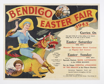
Poster, Bendigo Easter Fair, 1943
The first Bendigo Easter Fair was held on 10th and 11th April, 1871 and remains one of Australia’s longest running annual community events taking place over the Easter long weekend. Its purpose was to raise funds in aid of two local charities; The Bendigo Hospital, and The Bendigo Benevolent Asylum. The fair features events throughout the City with celebrations culminating in a parade on Easter Sunday. The parade features a variety of commercial and community groups including a large processional dragon which has been an integral part of the annual parade since 1892. The three principal golden dragons featured over the past 130 years are Loong (1892–1970), Sun Loong (1970–2019) and Dai Gum Loong (2019–present) which are housed at the Golden Dragon Museum in Bendigo. The Bendigo Easter Fair Society is custodian of the Bendigo Easter Fair and continues to support the City of Greater Bendigo’s largest festival. Each year the City produces a poster to advertise the upcoming fair and this one from 1943 reflects the war time sentiment which existed by featuring service men and women as well as the Chinese dragon. Commercially printed colour poster advertising the Bendigo Easter Fair featuring a woman riding a chinese dragon on the left hand side of print with two smaller images, one of service man in uniform bottom left and woman factory worker top right. The title appears in red lettering at top with details of the events appearing in the centre and lower sections on the right.Bendigo Easter Fair / 1943 / Carries On / and again invites all to keep smiling in the Nation's testing time, as all unite to aid its Charities. / Easter Saturday / April 24th / Monster Spectacular Street Carnival / and Popular Girl Contest / Easter Sunday / April 25th / Attend the specially patriotic Band gathering / in the upper reserve / See the unique oriental awakening / of the dragon at the Chinese Quarters / Patriotism, Pageantry, Music, and / Special Features throughout the Fair city of greater bendigo easter fair, mayor michelsen, bendigo chinese dragon, city of greater bendigo tourism, making a nation exhibition, city of greater bendigo events -
 Kiewa Valley Historical Society
Scales Weighing Pocket, circa early 1900s
Historically this item would have been used by gold miners, rabbit shooters, mobile "Rag and Bone" traders and other mobile(in caravans and/or horse drawn cart) traders of various small goods and haberdashery. Although marked as not to be used as trade, the isolation and sometimes difficult terrain rules out using larger and more delicate scales. In the early 1900s rough roads and severe weather conditions forced traders to be more flexible in trading with weights and measures. The "close enough is good enough" doctrine was the Australian outback rule of thumb.The significance of this item in the Kiewa Valley during this period demonstrates the slower acceptance of accurate trading measure using the country side principle "my hand shake is my bond". In the Kiewa Valley small quantity commercial undertakings e.g. gold mining, fur pelts and rabbit meat trade did not require bulk weight type scales. Commerce in rural production e.g. fruit and vegetables involved more farmers and their staff in a barter and/or "in kind" payments. This was more so in the depression years 1929 to late 1930s. Self sufficiency was to a large extent more attainable in this region than in the city/ large country town environment. The Australian "fair go" ethical approach to life and commerce was very much ingrained in those living in country regions, like Kiewa Valley as is demonstrated by the not so accurate hand balance, spring loaded scales.This brass "faced" portable Pocket Balance ( Fish Scales) has front plate made from thin pressed brass. The mild steel spring mechanism enclosed by black painted medium gauge steel cover( three quarters cylindrical). Front scale face and rear spring casing fastened by three rivets. Spring loaded marker blade is located in the centre of the front plate. A steel " finger holder" ring is attached at the top of the scale unit from one of two pre drilled holes. The top is for holding the scale upright and the bottom for a hook to dangle the item to be weighed from the bottom. See item KVHS 0223 for similar scales"THE BILLY BALANCE" and at the bottom "MADE IN GERMANY"antique pocket balance, scales, mobile weights, vintage appliances