Showing 3762 items
matching surveyed
-
 Glen Eira Historical Society
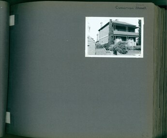
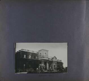
Album - Album page, Carnarvon Road, Circa 1972
This photograph is part of the Caulfield Historical Album 1972. This album was created in approximately 1972 as part of a project by the Caulfield Historical Society to assist in identifying buildings worthy of preservation. The album is related to a Survey the Caulfield Historical Society developed in collaboration with the National Trust of Australia (Victoria) and Caulfield City Council to identify historic buildings within the City of Caulfield that warranted the protection of a National Trust Classification. Principal photographer thought to be Trevor Hart, member of Caulfield Historical Society. Most photographs were taken between 1966-1972 with a small number of photographs being older and from unknown sources. All photographs are black and white except where stated, with 386 photographs over 198 pages. This house is part of HO14 Caulfield North and Environs - Heritage Overlay as a contributing property.Page 42 of Photograph Album with one photograph of a double-storey house on Carnarvon Road.Handwritten: Carnarvon Road [top right hand corner] / 42 [bottom right]trevor hart, caulfield north, carnarvon road, houses, verandahs, balconies, gardens -
 Glen Eira Historical Society
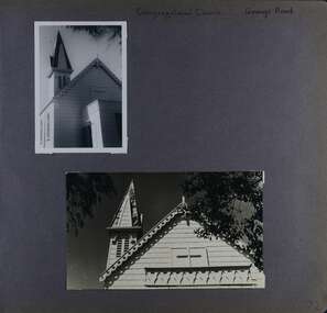
Album - Album page, Congregational Church, Grange Road, Circa 1972
This photograph is part of the Caulfield Historical Album 1972. This album was created in approximately 1972 as part of a project by the Caulfield Historical Society to assist in identifying buildings worthy of preservation. The album is related to a Survey the Caulfield Historical Society developed in collaboration with the National Trust of Australia (Victoria) and Caulfield City Council to identify historic buildings within the City of Caulfield that warranted the protection of a National Trust Classification. Principal photographer thought to be Trevor Hart, member of Caulfield Historical Society. Most photographs were taken between 1966-1972 with a small number of photographs being older and from unknown sources. All photographs are black and white except where stated, with 386 photographs over 198 pages. This church has since become the Greek Orthodox Church. From Victorian Heritage Database: Citation for Greek Orthodox Church HO84 https://vhd.heritagecouncil.vic.gov.au/places/43587 (as at 19/10/2020) The former Primitive Methodist, later Congregational, church at 152 Grange Road, Glenhuntly, is a small timber building, erected in 1885 (89?) in South Melbourne and relocated to Glenhuntly in 1909. It is a highly individual picturesque timber structure with distinctive spire and timber enrichment. It has aesthetic, historical and social significance. Its aesthetic value is derived from the choice of materials and picturesque Gothic Revival character showing American influence. Its historical value is derived from its survival as a rare example of a Primitive Methodist Church building whilst its social value hinges on its early roles as a place of worship for the Primitive Methodists in South Melbourne and the Congregationalists in Glenhuntly.Page 72 of Photograph Album with two photographs (one portrait and one landscape) of the upper exterior and tower of the Congregational Church on Grange RoadHand written: Congregational Church, Grange Road [top right] / 72 [bottom right] trevor hart, congregational church, grange road, gothic revival, carnegie, glen huntly, glenhuntly, greek orthodox church, primitive methodist church, spire, timber buildings -
 Glen Eira Historical Society
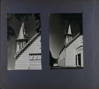
Album - Album page, Congregational Church, Grange Road, Circa 1972
This photograph is part of the Caulfield Historical Album 1972. This album was created in approximately 1972 as part of a project by the Caulfield Historical Society to assist in identifying buildings worthy of preservation. The album is related to a Survey the Caulfield Historical Society developed in collaboration with the National Trust of Australia (Victoria) and Caulfield City Council to identify historic buildings within the City of Caulfield that warranted the protection of a National Trust Classification. Principal photographer thought to be Trevor Hart, member of Caulfield Historical Society. Most photographs were taken between 1966-1972 with a small number of photographs being older and from unknown sources. All photographs are black and white except where stated, with 386 photographs over 198 pages. This church has since become the Greek Orthodox Church. From Victorian Heritage Database: Citation for Greek Orthodox Church HO84 https://vhd.heritagecouncil.vic.gov.au/places/43587 (as at 19/10/2020) The former Primitive Methodist, later Congregational, church at 152 Grange Road, Glen Huntly, is a small timber building, erected in 1885 (89?) in South Melbourne and relocated to Glenhuntly in 1909. It is a highly individual picturesque timber structure with distinctive spire and timber enrichment. It has aesthetic, historical and social significance. Its aesthetic value is derived from the choice of materials and picturesque Gothic Revival character showing American influence. Its historical value is derived from its survival as a rare example of a Primitive Methodist Church building whilst its social value hinges on its early roles as a place of worship for the Primitive Methodists in South Melbourne and the Congregationalists in Glenhuntly.Page 73 of Photograph Album with two photographs (both portrait) of front and side views of the spire of the Congregational Church on Grange RoadHand written: 73 [bottom left] trevor hart, congregational church, grange road, gothic revival, carnegie, glen huntly, glenhuntly, greek orthodox church, primitive methodist church, spire, timber buildings -
 Glen Eira Historical Society
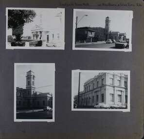
Album - Album page, Caulfield Town Hall cnr Hawthorn & Glen Eira Rds, Circa 1972
This photograph is part of the Caulfield Historical Album 1972. This album was created in approximately 1972 as part of a project by the Caulfield Historical Society to assist in identifying buildings worthy of preservation. The album is related to a Survey the Caulfield Historical Society developed in collaboration with the National Trust of Australia (Victoria) and Caulfield City Council to identify historic buildings within the City of Caulfield that warranted the protection of a National Trust Classification. Principal photographer thought to be Trevor Hart, member of Caulfield Historical Society. Most photographs were taken between 1966-1972 with a small number of photographs being older and from unknown sources. All photographs are black and white except where stated, with 386 photographs over 198 pages. Caulfield Town Hall is now known as Glen Eira Town Hall.From Victorian Heritage Database: Citation for Town Hall, Corner Glen Eira and Hawthorn Roads - HO106 https://vhd.heritagecouncil.vic.gov.au/places/43613 as at (19/10/2020) The former City of Caulfield (now City of Glen Eira) Municipal Offices, located at the south-west corner of Hawthorn and Glen Eira Roads, Caulfield South, were commenced for the Borough of Caulfield in 1884 when they also included a Post and Telegraph Office and Court of Petty Sessions. They were designed by the Borough surveyor, Sydney Smith. The hall was completed in 1890 to the design of Alexander Rankin and the present hall, foyer and portico completed to the design of Goldsmith and Jenkin, architects, in 1931. The complex is historically, aesthetically and socially significant. It is historically significant {Criterion A) as the centre of Local Government services in the area since 1885 and as a centre of post and telegraph and legal services for a period. Its association with architect and Borough surveyor, Sydney W. Smith is important in that the east elevation and facade (ground floor level only)as far west as the tower (lower two stages) survive as evidence of his work, the practice which his son continued after his death in 1886, becoming highly successful. The work of Goldsmith and Jenkin is historically important in that it indirectly demonstrates the growth of the City sustained during the Inter-war period, the work proceeding in spite of the Depression. It compares with other similar work of that time including the refurbishment of the Malvern Municipal Offices and Hall in 1927 (Hudson and Wardrop), the Melbourne Corporation Offices and Hall in 1925-28 (Stephenson and Meldrum, A. and K. Henderson) and the Camberwell Offices and Council Chamber in 1924 (Leighton Irwin and Roy Stevenson), other comparable municipal projects being undertaken during the 1930s. Finally, the Goldsmith and Jenkin works are important as a project of the Depression years organised specifically to alleviate unemployment problems in the Municipality. The complex is aesthetically important (Criterion E) as a prominent and imposing Classically derived complex of its type with individually noteworthy interior spaces being the entry hall and staircase, main Hall, Foyer and Council Chamber. The Adamesque plasterwork, timber panelling and furniture, Art Nouveaux enrichment and Classically derived treatment with sparing use of Australian decorative motifs are contributory elements. Exterior .elements of note include the remains of the original design prepared by Sydney Smith and the clock tower and portico which have come to symbolise important Municipal complexes erected prior to the Second World War. The complex is socially important (Criterion G) for the value placed on it by the community which has made use of it for activities including that of Local government for well over a century.Page 74 of Photograph Album with four photographs (three portrait and one landscape) of different views of the Caulfield Town Hall.Hand written: Caulfield Town Hall cnr Hawthorn & Glen Eira Rds [top right] / 74 [bottom right] trevor hart, caulfield, glen eira, caulfield town hall, sydney smith, sydney w smith, municipal, adamesque plasterwork, adamesque, art nouveaux, portico, council chambers, alexander rankin, foyer, local government, timber panelling, tower, unemployment, clock tower, hawthorn road, glen eira road, city of glen eira, municipal offices, post and telegraph office, goldsmith and jenkin, courthouses, surveyors, architects, classical architectural style, streetscapes, gardens, cars, glen eira town hall, depression 1929-1939 -
 Glen Eira Historical Society
Album - Album page, Caulfield Town Hall cnr Hawthorn & Glen Eira Rds, Circa 1972
This photograph is part of the Caulfield Historical Album 1972 but is noted as taken in 1922. This album was created in approximately 1972 as part of a project by the Caulfield Historical Society to assist in identifying buildings worthy of preservation. The album is related to a Survey the Caulfield Historical Society developed in collaboration with the National Trust of Australia (Victoria) and Caulfield City Council to identify historic buildings within the City of Caulfield that warranted the protection of a National Trust Classification. Principal photographer thought to be Trevor Hart, member of Caulfield Historical Society. Most photographs were taken between 1966-1972 with a small number of photographs being older and from unknown sources. All photographs are black and white except where stated, with 386 photographs over 198 pages. Caulfield Town Hall is now known as Glen Eira Town Hall.From Victorian Heritage Database: Citation for Town Hall, Corner Glen Eira and Hawthorn Roads - HO106 https://vhd.heritagecouncil.vic.gov.au/places/43613 as at (19/10/2020) The former City of Caulfield (now City of Glen Eira) Municipal Offices, located at the south-west corner of Hawthorn and Glen Eira Roads, Caulfield South, were commenced for the Borough of Caulfield in 1884 when they also included a Post and Telegraph Office and Court of Petty Sessions. They were designed by the Borough surveyor, Sydney Smith. The hall was completed in 1890 to the design of Alexander Rankin and the present hall, foyer and portico completed to the design of Goldsmith and Jenkin, architects, in 1931. The complex is historically, aesthetically and socially significant. It is historically significant {Criterion A) as the centre of Local Government services in the area since 1885 and as a centre of post and telegraph and legal services for a period. Its association with architect and Borough surveyor, Sydney W. Smith is important in that the east elevation and facade (ground floor level only)as far west as the tower (lower two stages) survive as evidence of his work, the practice which his son continued after his death in 1886, becoming highly successful. The work of Goldsmith and Jenkin is historically important in that it indirectly demonstrates the growth of the City sustained during the Inter-war period, the work proceeding in spite of the Depression. It compares with other similar work of that time including the refurbishment of the Malvern Municipal Offices and Hall in 1927 (Hudson and Wardrop), the Melbourne Corporation Offices and Hall in 1925-28 (Stephenson and Meldrum, A. and K. Henderson) and the Camberwell Offices and Council Chamber in 1924 (Leighton Irwin and Roy Stevenson), other comparable municipal projects being undertaken during the 1930s. Finally, the Goldsmith and Jenkin works are important as a project of the Depression years organised specifically to alleviate unemployment problems in the Municipality. The complex is aesthetically important (Criterion E) as a prominent and imposing Classically derived complex of its type with individually noteworthy interior spaces being the entry hall and staircase, main Hall, Foyer and Council Chamber. The Adamesque plasterwork, timber panelling and furniture, Art Nouveaux enrichment and Classically derived treatment with sparing use of Australian decorative motifs are contributory elements. Exterior .elements of note include the remains of the original design prepared by Sydney Smith and the clock tower and portico which have come to symbolise important Municipal complexes erected prior to the Second World War. The complex is socially important (Criterion G) for the value placed on it by the community which has made use of it for activities including that of Local government for well over a century.Page 75 of Photograph Album with one portrait photograph of the exterior of Caulfield Town Hall taken in 1922.Hand written: FEBRUARY 1922 [under photo] / 75 [bottom left] trevor hart, caulfield, glen eira, caulfield town hall, sydney smith, sydney w smith, adamesque plasterwork, art nouveaux, portico, council chambers, alexander rankin, foyer, local government, timber panelling, tower, unemployment, clock tower, hawthorn road, glen eira road, city of glen eira, municipal offices, palms, gardens, post and telegraph offices, goldsmith and jenkin, architects, city of caulfield, ivy clad walls, surveyors, depression 1929-1939, glen eira town hall -
 Glen Eira Historical Society
Plan - Warrigal Road, Oakleigh
Documents about a small portion of land on Warrigal Road Oakleigh, now Oakleigh East. A Letter dated 29/05/1952 from Gas and Fuel Corporation of Victoria to Mr. L.P. Simmonds requesting valuation of land for proposed widening of Warrigal Road. A plan of Survey, no.5474, for Crown portion of Parish of Moorabbin and Parish of Mordialloc for owner The Brighton Gas Coy Ltd. New Street Brighton. Mortgages to the National Mutual Life Association. A letter dated 04/06/1952 from Gas and Fuel Corporation of Victoria in reference to Warrigal Road and Centre Road from the Country Roads Board who desire to acquire the land. Handwritten calculation notes and price for valuation, most likely as an attachment to the letter dated 04/06/1952.gas and fuel corporation, warrigal road, centre road, moorabbin council, simmonds l.p, survey plan, county of bourke, the brighton gas company ltd., country roads board, the national mutual life association of australia ltd., bentleigh east -
 Bendigo Military Museum
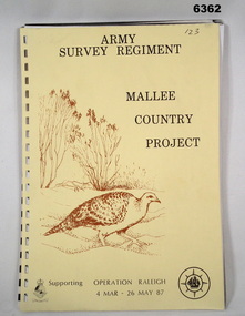
Administrative record - Army Survey Regiment - Malee Country Project 4 Mar - 26 May 1987, Army Survey Regiment, Bendigo, 30 Jun 1987
Project Mallee Country was support provided to Operation Raleigh by members of the Army Survey Regiment during the period 4 Mar - 26 May 1987. This is the report on their activities. Colonel John Blashford-Snell and Prince Charles launched Operation Drake in 1978, running youth projects from ships circumnavigating the globe, to develop self-confidence and leadership through adventure, scientific exploration and community service. In two years 414 young people took part in the round the world voyage, working on land-based projects in 16 countries. Following the success of Operation Drake, the much more ambitious Operation Raleigh was established in 1984, and ran for five years until 1989. The success of Operation Raleigh saw it continue on a permanent basis in 1988, with an emphasis on land-based expeditions.A4 Report, beige coloured cover, brown motif of Mallee Fowl, containing typed paper pages, poor quality photocopied photos and diagrams, unbound.royal australian survey corps, rasvy, fortuna, army survey regiment, army svy regt, asr -
Victorian Aboriginal Corporation for Languages
Book, C C Culvenor, The boundaries of the Mount Franklin Aboriginal Reserve, 1992
"This enquiry into the boundaries of the Mount Franklin Aboriginal Reserve had its origins in the preparation of a biography of geologist Thomas Smith of Sandon, which raised queries about Boundary Gully Road, Parkers Gully and the location in that vicinity of the Reserve boundary. At a subsequent meeting of the Daylesford Historical Society, commemorating the 150th anniversary of the founding of the Aboriginal Reserve at Franklinford in 1841, it became clear that the actual boundaries were only poorly known ... A search for information srouces in Melbourne and Sydney did not produce an overall Plan, but it is hoped that the material obtained will present a sufficiently accurate picture to be useful to other local historians and be of some interest also to the general reader" --Preface. Contents: The boundaries of the Mt. Franklin Aboriginal Reserve The five mile radius The Tarrengower challenge Provisional boundaries Survey of the Reserve Breakup of the Reserve References Appendices.maps, b&w illustrations, b&w photographsmount franklin -
 Kew Historical Society Inc
Plan, Melbourne & Metropolitan Board of Works : Borough of Kew : Detail Plan No.1592, 1905
The Melbourne and Metropolitan Board of Works (MMBW) plans were produced from the 1890s to the 1950s. They were crucial to the design and development of Melbourne's sewerage and drainage system. The plans, at a scale of 40 feet to 1 inch (1:480), provide a detailed historical record of Melbourne streetscapes and environmental features. Each plan covers one or two street blocks (roughly six streets), showing details of buildings, including garden layouts and ownership boundaries, and features such as laneways, drains, bridges, parks, municipal boundaries and other prominent landmarks as they existed at the time each plan was produced. (Source: State Library of Victoria). This plan forms part of a large group of MMBW plans and maps that was donated to the Society by the Mr Poulter, City Engineer of the City of Kew in 1989. Within this collection, thirty-five hand-coloured plans, backed with linen, are of statewide significance as they include annotations that provide details of construction materials used in buildings in the first decade of the 20th century as well as additional information about land ownership and usage. The copies in the Public Record Office Victoria and the State Library of Victoria are monochrome versions which do not denote building materials so that the maps in this collection are invaluable and unique tools for researchers and heritage consultants. A number of the plans are not held in the collection of the State Library of Victoria so they have the additional attribute of rarity.Original survey plan, issued by the MMBW to a contractor with responsibility for constructing sewers in the area identified on the plan within the Borough of Kew. The plan was at some stage hand-coloured, possibly by the contractor, but more likely by officers working in the Engineering Department of the Borough and later Town, then City of Kew. The hand-coloured sections of buildings on the plan were used to denote masonry or brick constructions (pink), weatherboard constructions (yellow), and public buildings (grey). In MMBW Plan No.1592, the pink line indicates that area of the plan for which the contracting engineer was responsible. Included in the Plan are a number of primarily brick villas in a section of Belmont Avenue off Cotham Road. The house ‘Uvadale’ north of Belmont Avenue, and facing Cotham Road is also included in the contract. Excluded from the contract but shown on the Plan are ‘Glendonald’, ‘Mont Belmont’ and ‘Gilden’.melbourne and metropolitan board of works, detail plans, survey plans - borough of kew, mmbw 1592, cartography -
 City of Kingston
Photograph - Black and white, 20 December 1945
Cheltenham is a suburb in the City of Kingston that was originally established as a rural market gardening community. The area is bordered by Highett, Mentone and Heatherton. The market gardens, farms and paddocks have gradually been sub-divided into housing and industrial estates. The Southland shopping centre is a major feature of the area.Cheltenham was established as a rural market gardening community. The Le Page family lived in Cheltenham since 1854 when Nicholas Le Page, a tailor from the Channel Island of Guernsey, bought two acres of land on Chesterville Road near Bernard Street to establish a market garden. Over the years the Le Pages purchased more land in the area. In 1875-76 Nicholas' son Frank and his wife Mary built 'Daphne Cottage' near the corner of Bernard and Wilson Streets. n the 1940s Frank's son, Everest Le Page, bought five more lots of land in Chesterville Road from the Tuck family. The Le Pages grazed horses, ponies and cows on this land, and grew pumpkins, carrots, parsnips, onions, potatoes and cabbages. Many buildings and locations within in Cheltenham commemorate the Le Page family's contribution to the Cheltenham community.Aerial photograph taken in 1945 of the Cheltenham district within the City of Kingston. The image includes Chesterville Road, the future site of Turner Road pool (now Waves) and Highett Reserve, (top left), Jellicoe Street, Argus Street, Bernard Street, Wilson Street, the Methodist Children Homes (now Southland), McIvor Street, Goulburn Street, Nepean Highway, Jamieson Street and Barker Street (bottom left), market gardens and paddocks. In the top centre of the image, "Daphne Cottage", the home of Frank T. Le Page is visible on the corner of Bernard and Wilson Streets. Much of the land depicted in this image was owned by the Le Page family. This image is possibly from the collection of aerial photographs commissioned by the Department of Crown Lands and Survey and taken by Adastra Airways.Black and white ink: 57250 White print: VIC-170 57250 20.12.45 Run 6 PROJ. No. 5 MELB. METROP AREA Black type 10200 FTS 30' LENS 20.12.45cheltenham, market gardens, industry, le page family -
 City of Kingston
Photograph - Black and white, 20 December 1945
This aerial photograph depicts the changing landscape of Cheltenham and Highett since WWII. Photographed in 1945, there is a mix of urban dwellings and industrial development and precedes the major transformation of Cheltenham with the development of the Southland shopping centre in the 1960s and expansion in the 1990s.A large part of Cheltenham was originally established as a rural market gardening community. The railway line and station brought urban development to the area and in the north, the Highett area was dominated by the Highett Gas Works. Cheltenham became a major destination for shopping in the 1960s with the opening of Southland.Aerial photograph taken in 1945 of Cheltenham and Highett within the City of Kingston. The image includes the Highett Reserve, (top right), the Methodist Children Homes (now Southland), Nepean Highway and Jamieson Street. Highett Gas Works is visible in the top left and the land now named William Fry Reserve at the intersection of Bay Road and Nepean Highway. A visible large parcel of land on the corner of Bay Road and Nepean Highway was developed in the 1990s as the west side addition to Southland. The densely vegetated area in the upper right sector of the image is now dense with housing. Tulip Grove, Heather Grove and Gilford Street are visible bottom left. This image is possibly from the collection of aerial photographs commissioned by the Department of Crown Lands and Survey and taken by Adastra Airways.Black ink: 57252 White lettering: VIC-10 57252 20.12.45 [lens information indecipherable] PROJ. No.5 MELB. METROP AREA Black pencil: 80highett, cheltenham, highett gas works, urbanisation -
 City of Kingston
Photograph - Black and white, 20 December 1945
This aerial photograph depicts the changing landscape of Cheltenham and Highett since WWII. Photographed in 1945, there is a mix of urban dwellings and industrial development and precedes the major transformation of Cheltenham with the development of the Southland shopping centre in the 1960s and expansion in the 1990s.A large part of Cheltenham was originally established as a rural market gardening community. The railway line and station brought urban development to the area and in the north, the Highett area was dominated by the Highett Gas Works. Cheltenham became a major destination for shopping in the 1960s with the opening of Southland.Aerial photograph taken in 1945 of Cheltenham and Highett within the City of Kingston. The image includes the Highett Reserve, (top right), the Methodist Children Homes (now Southland), Nepean Highway and Jamieson Street. Highett Gas Works is visible in the top left and the land now named William Fry Reserve at the intersection of Bay Road and Nepean Highway. A visible large parcel of land on the corner of Bay Road and Nepean Highway was developed in the 1990s as the west side addition to Southland. The densely vegetated area in the upper right sector of the image is now dense with housing. Tulip Grove, Heather Grove and Gilford Street are visible bottom left. This image is possibly from the collection of aerial photographs commissioned by the Department of Crown Lands and Survey and taken by Adastra Airways.Black type: Reverse lettering VIC-10 57252 20.12.45 [lens information indecipherable] PROJ. No.5 MELB. METROP AREA White lettering: Reverse writing 57252cheltenham, highett, highett gas works, urbanisation -
 Federation University Historical Collection
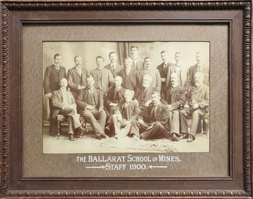
Photograph - Photograph (Black & White), Senior Members of the Ballarat School of Mines Staff, 1900
Staff Members of the Ballarat School of MinesA black and white photograph showing 18 men. Standing L-R: S.B. Vial (Chemistry); W. Doepel (Clerk); Alfred E.C. Kerr (Mechanical Engineering); Arthur Garrard (Battery Manager); Henry Hall (Drawing); W. Kerr Grant (Mathematics); C.E. Campbell (Photography); J.M. Sutherland (Electricity); H.R. Murphy (Assayer); Charles A. Dean (Cyanide Works). Sitting: Daniel Walker (Chemistry); Thomas S. Hart (Mineralogy & Curator); Fred. J. Martell (Registrar); Alfred Mica Smith, Senior Professor (Chemistry, Metallurgy, etc); J.S. Dawburn (Engineering & Surveying); Dr J.F. Usher (Materia Medica). Seating (Front): P.A. Osborne (Assistant Assayer); Godfrey Hart (Museum). .2) is a framed copy of the photograph in a carved timber from from Peake's BallaratFramer's plate 'Peake's Ballarat' Framed mount 'The Ballarat School of Mines, Staff 1900'ballarat school of mines, alfred mica smith, daniel walker, thomas hart, s.b. vial, w doepel, alfred kerr, arthur garrard, henry hall, w kerr grant, ce campbell, john sutherland, hr murphy, charles dean, fred martel, j.s. dawburn, j.f. usher, p.a. osborne, godfrey hart, c.e. campbell, w. kerr grant, kerr grant -
 Bendigo Historical Society Inc.
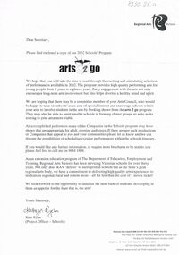
Document - MERLE HALL COLLECTION: CORRESPONDENCE AND DOCUMENTS RE REGIONAL ARTS VICTORIA
Correspondence and Documents re Regional Arts Victoria; a. Correspondence In re 2002 Schools Program ''Arts 2 Go'' from Project Officer - Schools; b. Production Questionnaire for Presenters - this form has been filled in for Regional Arts Victoria with regard to an un-named production/no date; c. Appendix E - Acquittal Information - one page filled in re the Production ''100 - An Australian Journey (Touring Exhibition) 2001; d. Tax Invoice to Regional Arts Victoria fee ''Balance due on 100-000 Exhibition on closing of Exhibition (with photocopy of cheque) - perhaps relating to item 8350.34.c??; e. Marketing and Audience Development Questionnaire September 2001 - one page only with basic information about AB and the note that as AB is disbanding ''it would seem irrelevant for us to complete this survey''. -
Bendigo Historical Society Inc.
Map - BENDIGO, 1916
Map. Bendigo, Gunbower, Gladstone, Talbot, Dalhousie, Rodney, Jarklan, Calivil, Hayanmi, Mitiamo, Wanurp, Pannoobamawm, Bamawm, Millewa, Ballendella, Janiember West, Janiember East, Pompapiel, Talambe, Dingee, Milloo, Pannoomilloo, Rochester West, Yarrayne, Salisbury, Yallook, Tandarra, Kamarooka, Warragamba, Diggorra, Minto, Bridgewater, Yarraberb, Neilborough, Whirrakee, Egerton, Elmore, Nolan, Goornong, Bagshot, Huntly, Derby, Leichardt, Nerring, Tarnagulla, Woodstock, Marong, Sandhurst, Wellsford, Bendigo, Axedale, Strathfieldsaye, Eppalock, Kimbolton, Lyell, Sedgwick, Mandurang, Lockwood, Ravenswood, Shelbourne, Laanecoorie. Price 3/-. Smaller map of State of Victoria. Lithographed at the Department of Lands and Survey, Melbourne. 1916. Scale : Two miles to one inch. Map was in book form. (number 62 in map cupboard 1)map, bendigo, bendigo -
 Bendigo Historical Society Inc.
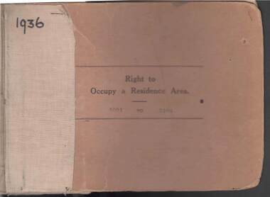
Book - RIGHT TO OCCUPY RESIDENCE AREA COLLECTION: REGISTER 1936
COLLECTION OF RIGHT TO OCCUPY A RESIDENCE AREA -LAND (RESIDENCE AREAS ) Act 1935 / thick cardboard book -cloth and string binding / written on front in texter '1936' / numbers 5001 to 5100 / inside - stubs of documents showing Granted to , of, period, Date of Right , Description of Land , Allotment, Section, City, Town , Borough , Township of , Parish of , Authorised Person . Rubber stamps show The interest of this Right has been transferred to /one stub shows Department of Lands and Survey note on Bendigo Historical Society Catalogue Sheet dated 12.6.2008 All buts completed and original application forms removed. Note -forms were originally in triplicate on one page with serrations for removal of two parts; butts remain .Residence areas in Central Goldfields.Bendigo City Council - Acquisition 1990organization, government, official -
 Bendigo Historical Society Inc.
Document - JOHN EVANS COLLECTION: EPHEMERA
Various documents located within the 'J Evans Collection' (Original Box 6). . A. Shire of Marong - Valuation Notice to Mr John Evans, Sydney Flat August 1913; b Examination questions for Subject X - Inorganic Chemistry May 1888 (Examinaers names and Professor's names given - where??; c. Letter from Office and Lands and Survey to Mr John Dolman Junior, Kamarooka re failure of application for a lease in the area; d. Letter to Mr Evans from Annie Murray, Chum Street re request for meeting re house and meeting with bank manager (on bereavment card?!!); e. part of page (handwritten) re Crown Grant in the name of Isabel Evans (title details).; f. Certificate of Marriage between William Johns and Charlotte Stewart , 6th March 1893, Eaglehawk.ephemera, mementoes, general interest -
 Kiewa Valley Historical Society
Maps - Bogong x2, Tawonga, Omeo, Dargo, Victoria and others, 1. Bogong Alpine Area; 2. Bogong 8324; 3. Tawonga Topographical; 4. Omeo 8433; 5. Dargo 8323; 6. Victoria State
1. Bogong Alpine Area (outdoor Leisure Map. survey & Mapping Victoria, Government of Victoria, Edition 2, reprinted 1991 with an image of Mt. Feathertop on the front. Information for tourist in the Alpine National Park: Bogong Area. Including: recreational activities, history, weather and vegetation and a list of walks together with locality maps and photographs. The front cover has an image of Mt Feathertop against a blue sky with yellow writing 'Bogong Alpine Area', there is a yellow triangular block on the right hand top corner with black writing 'Outdoor Leisure Map. On the bottom edge is a block of yellow with black writing 'Survey & Mapping Victoria' and a light green map of Victoria with 'VICMSP' printed in white. 2. 8324 Bogong Victoria, Edition 1, Commonwealth of Australia 1981. A topographical Map: 1:100,000 scale (1 cm to 1 KM). Map has a red cover with white writing together with a white block and black writing and a map insert. 3. Tawonga Topographical Map - Forests Commission Victoria, / revised 5/9/77, DEG No. 68-G/399. A Tawonga 803 folded map in a beige colour with the back blank. 4. Omeo 8433 Victoria, Edition 1, Department of Natural Resources. The map has a red and white cover with black writing and a simple map of Australia at the bottom. 5. 8323 Dargo, Edition 1, Commonwealth of Australia. A red and white cover with a map insert. 6. Victoria State Map, Hema Maps, 2002. Hema Maps, State Map, colourful cover with a map of Australia and four tourism photographs. Scale 1: 850,000 An inscription handwritten in blue pen "Trappers Gap to Mitta Mitta 1" to 1 mile". There are some pen markings and notations of tracks.maps, bogong, omeo, tawonga, dargo, victoria, bogong alpine area -
 Falls Creek Historical Society
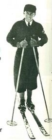
Equipment - Martin Romuld's Skis, 1933
Martin Romuld was born near Trondheim in Norway on September 26, 1905. He started jumping on skis at age 6 or 7 and became very good at it. He completed his degree in Civil Engineering at the University of Trondheim and decided to come to Australia. He arrived on 7 March 1928 and found a job with the SEC. The SEC wanted to investigate the possibility of a hydrological surveys necessary to determine the flow of water over a period of years. These surveys started in 1934 and continued until 1941. He lived at Wilkinson’s hut for most of the time during those years both in summer and winter. In his role with the SEC, Martin visited all the various creeks to measure water flow rates as often as was necessary. These skis were used on his winter rounds during the time he spent in the area. Martin also competed in skiing during the 1930s. He won the combined Australian title 3 or 4 times. He was unbeatable in cross country, probably due to the continual practice in his job. Before migrating to Australia, Martin had been runner up in the 1926 European Jump Championships held in France. Jumping was his favourite thrill and he would often construct a jump for practice near the Scout Hut (or Rover Chalet) quite near to Wilkinson’s. In 1941 Martin joined the Royal Australian Air Force and after the War skied mainly at Mt Buller. He maintained his involvement in competitive skiing as an official. In 1958 Martin was the main judge of the National jump which was held to the left of the Nissen tow. He also designed the jumping course at the Donna Buang snow fields. Martin Romuld was Co Vice-President of the Federation of Victorian Ski Clubs in 1949, along with Tom Mitchell M.L.A. Martin Romuld died on 14 July 1998 in Prahran, Victoria,These skis are significant because they belonged to a pioneer of Falls Creek and the sport of skiing in Australia.A set of skis made for Martin Romuld. They are made from American hickory which arrived in Australia via Norway in October 1933. Andy Broad made the skis and they were furnished with steel edges. There was enough hickory for 18 pairs of skis and a pair of competition cross country skis were also made for Martin Romuld. martin romuld', falls creek pioneers, australian skiing history -
 City of Moorabbin Historical Society (Operating the Box Cottage Museum)
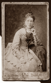
Photograph, B&W Elizabeth Avis Box c1880, c1880
William Box was born in 1834 in Withyham , Sussex England and married Elizabeth Avis 13th November 1854 at Tunbridge Wells, Kent England. Elizabeth Avis was the daughter of Thomas and Eleanor aka Ellen Avis nee Robinson . In 1855 they sailed to Australia aboard the SS Omega. At first they rented a block of land on Jasper Road East Brighton ( now McKinnon / Ormond). that was part of the Henry Dendy Special Survey 1841. An early settlers’ hut on the site became their home and they farmed the land and were soon able to purchase the block. They raised 13 children and the Cottage was extended as required. In 1984 that early settler cottage was found in a dilapidated state by Laurie Lewis, in his Timber Yard in Jasper Rd Ormond.. The Moorabbin City Council, Federal Government, Mr Lewis and CMHS members reconstructed the Cottage in 1985 . Box Cottage Museum, a reconstruction of an early settler hut, is named after the Box family who resided there 1865 -1913 . The William Box and Elizabeth Avis Box raised 13 children and lived in the early settler cottage and farmed on the block of land in Jasper Road, East Brighton ( now McKinnon / Ormond) that was part of the Henry Dendy Special Survey 1841 Inscribed in Album “ The early photos in this album were found by Mr (Laurie) Lewis when he was demolishing the Old Box Cottage. He gave them to Mrs Avis Box Eldridge who in turn gave them to me. They were not identified. I believe they rightly belong in the Cottage. I have attempted to identify them and present them in a way they can be preserved as a historical record of the era.” A B Leigh A black and white photograph of Elizabeth Avis Box who married William Box 1854 ALBUM "Australian Coat of Arms" PORTRAITbox george, box mary, box william, box elizabeth honor, box alonzo, box mary louisa, dendy henry, were j b, dendy's special survey 1841, brighton, moorabbin, bentleigh, mckinnon, ormond, market gardeners, dairy farms, early settlers, pioneers, jasper road, gurr jabez, gurr eliza, pay henry, pay anna, ward willam, box henry, ward elizabeth emma, box john, sheldrake martha, rushall eleanor, box caroline, box elizabeth avis, -
 Federation University Historical Collection
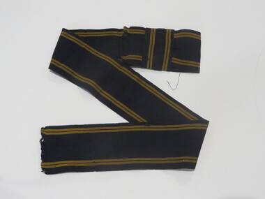
Clothing - Costume Accessories, School of Mines Hat Band, mid 1900s
Tertiary education at Ballarat began with the establishment of the School of Mines in 1870, making it Australia's third oldest tertiary institution. Classes began in surveying, mathematics, chemistry and a decade later they included metallurgy, assaying and geology. The technical division provided such programs as wool classing, plumbing and bricklaying. In 1967, it was split into three separate institutions, Ballarat School of Industries, Ballarat Technical School, and Ballarat Institute of Advanced Education. Then in 1976 the Ballarat Institute of Advanced Education became into Ballarat College of Advanced Education. The Ballarat School of Industries and Ballarat Technical School became the School of Mines and Industries, Ballarat (SMB). In 1998, the Ballarat School of Mines and Industries and the Horsham-based Wimmera Institute of TAFE merged with the University of Ballarat. The university merged with Monash University's Gippsland (Churchill) campus in 2013 and the merged schools are now the Federation University AustraliaThis woven band of dark blue has two narrow bands of gold on either side. It has a 4cm turn back at the end, which is held by a folded and stitched piece of the same band placed at ninety degrees around the band. school of mines ballarat, hat band, uniform, costume, textiles -
 Federation University Historical Collection
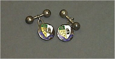
Accessory - Object, School of Mines Ballarat Cuff Links, c1920s
Tertiary education at Ballarat began with the establishment of the School of Mines in 1870, making it Australia's third oldest tertiary institution. Classes began in surveying, mathematics, chemistry and a decade later they included metallurgy, assaying and geology. The technical division provided such programs as wool classing, plumbing and bricklaying. In 1967, it was split into three separate institutions, Ballarat School of Industries, Ballarat Technical School, and Ballarat Institute of Advanced Education. Then in 1976 the Ballarat Institute of Advanced Education became into Ballarat College of Advanced Education. The Ballarat School of Industries and Ballarat Technical School became the School of Mines and Industries, Ballarat (SMB). In 1998, the Ballarat School of Mines and Industries and the Horsham-based Wimmera Institute of TAFE merged with the University of Ballarat. The university merged with Monash University's Gippsland (Churchill) campus in 2013 and the merged schools are now the Federation University AustraliaThese circular cuff links are the Coat of Arms of the School of Mines Ballarat and are made of sterling silver and white, yellow, green and blue enamel attached by three links to a small bar with dumb bells. On face - Ingenio Effodere Opesschool of mines ballarat, school crest, cuff links -
 Federation University Historical Collection
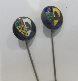
Object, School of Mines Ballarat Lapel Badge, c1920s
Tertiary education at Ballarat began with the establishment of the School of Mines in 1870, making it Australia's third oldest tertiary institution. Classes began in surveying, mathematics, chemistry and a decade later they included metallurgy, assaying and geology. The technical division provided such programs as wool classing, plumbing and bricklaying. In 1967, it was split into three separate institutions, Ballarat School of Industries, Ballarat Technical School, and Ballarat Institute of Advanced Education. Then in 1976 the Ballarat Institute of Advanced Education became into Ballarat College of Advanced Education. The Ballarat School of Industries and Ballarat Technical School became the School of Mines and Industries, Ballarat (SMB). In 1998, the Ballarat School of Mines and Industries and the Horsham-based Wimmera Institute of TAFE merged with the University of Ballarat. The university merged with Monash University's Gippsland (Churchill) campus in 2013 and the merged schools are now the Federation University AustraliaThese Coat of Arms of the School of Mines Ballarat are circular lapel badges and are made of sterling silver and enamel. The circular disc is attached to a long pin. 1). The enamel is yellow, green and blue 2). The enamel is white, yellow, green and blueOn face - Ingenio Effodere Opesschool of mines ballarat, school crest, lapel pins -
 Federation University Historical Collection
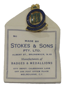
Object, Stokes & Sons Pty Ltd, School of Mines Ballarat Brass and Enamel Badge, mid 1900s
Tertiary education at Ballarat began with the establishment of the School of Mines in 1870, making it Australia's third oldest tertiary institution. Classes began in surveying, mathematics, chemistry and a decade later they included metallurgy, assaying and geology. The technical division provided such programs as wool classing, plumbing and bricklaying. In 1967, it was split into three separate institutions, Ballarat School of Industries, Ballarat Technical School, and Ballarat Institute of Advanced Education. Then in 1976 the Ballarat Institute of Advanced Education became Ballarat College of Advanced Education. The Ballarat School of Industries and Ballarat Technical School became the School of Mines and Industries, Ballarat (SMB). In 1998, the Ballarat School of Mines and Industries and the Horsham-based Wimmera Institute of TAFE merged with the University of Ballarat. The university merged with Monash University's Gippsland (Churchill) campus in 2013 and the merged schools are now the Federation University Australia. Gold coloured School of Mines Ballarat brass badges with blue and green enameling. Box of 72 (8 are loose in the box but 64 are in individual packets).On face - Ballarat School of Mines, Ingenio Effodere Opes Stamped into back - Stokes Melbballarat school of mines, badge, stokes and sons, numismatics -
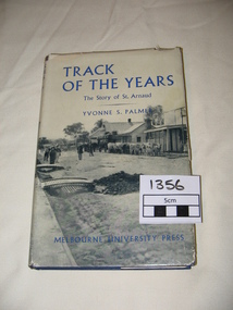 St Arnaud and District Historical Society
Book. Track of the Years, Track Of The Years. The Story of St.Arnaud.By Yvonne S Palmer
TRACK OF THE YEARS. The Story of St.Arnaud by Yvonne S Palmer had aroused local interest when this book was presented in 1955.The fortunes of this prosperous community, whose origins go back to the excitement of of the New Bendigo gold-rush, gleaned from an unusual wealth of reminiscences,diaries, letters, newspapers and photograph albums, are now placed permanently on record in this fascinating narrative. Contents: The New Bendigo Goldrush, Pastoral Settlement, The Aborigines of the Eastern Wimmera, A Permanent Goldrush, The Township Surveyed, Councils at Work 1861- 1870, Local Government in the District. 1861-1870. Sons of the Antipodes, Diggers in Townsmen, Daughters and Wives, Companies and Miners, Mining Settlements, Increasing Needs, Not by Bread Alone, The beginning of Farming, The Changing Countryside, A New St.Arnaud has Come, Deep Sinking and Dividends, Fewer farmers- Larger farms, Pride but not Complacency.Track of The Years by Yvonne S. Palmer. The Story of St.Arnaud. Hardcover book, blue cover with black and white photograph on the dustcover.Includes photographs and maps.308 pages, 1st Edition.1st Edition Published by Melbourne University Press in 1955. 308 pages. -
 Warrnambool and District Historical Society Inc.
Ledger, Chadwick Copying Book Co, Letter book 1905, 1902
This letter book has maps, letters and plans dating from 1902 to 1905. It came from the office of John William Crawley, Junior, an engineer, architect and surveyor in private practice in Warrnambool and also the engineer for the Shire of Warrnambool from 1895 to 1935. His father, brother and son were all engineers and worked in that capacity or as Shire Secretary for the Shire of Warrnambool, with the Crawley family recording a total of 132 years of service to the Shire of Warrnambool. The Shire of Warrnambool existed from 1863 to 1994. This letter book was passed on to John Crawley’s son, Rolf, engineer for the Shire of Warrnambool from 1935 to 1968. The letter book then came into the possession of Michael Hand who took over the private surveying business of Rolf Crawley in Warrnambool. The Warrnambool and District Historical Society acquired the letter book, along with several other Crawley ledgers, from the Michael Hand estate. This letter book is of considerable importance as it contains the letters, maps and plans produced by John William Crawley Junior, a Shire of Warrnambool engineer for 40 years. It will be useful to researchers. This is a black hard cover letter book of 505 pages, plus an alphabetical index at the back of the book. The letter book contains handwritten letters, sketch maps and plans. There is gold lettering on the spine.‘1’ ‘Invoice’ ‘Chadwick Copying Book Co. Springfield Mass.’ john william crawley, junior, warrnambool, rolf crawley, warrnambool, shire of warrnambool, history of warrnambool -
 Warrnambool and District Historical Society Inc.
Ledger, Letter book 1892-1904, 1892
This letter book has letters, sketch maps and plans and dates from 1892 to 1904. It came from the office of John William Crawley, Junior, an engineer, architect and surveyor in private practice in Warrnambool and also the engineer of the Shire of Warrnambool from 1895 to 1935. His father, brother and son were also engineers and worked in that capacity or as the Shire Secretary for the Shire of Warrnambool, with the Crawley family recording a total of 132 years of service to the Shire. This letter book was passed on to John Crawley’s son, Rolf Crawley, Engineer for the Shire of Warrnambool from 1935 to 1968. The letter book then came into the possession of Michael Hand who took over the private surveying business of Rolf Crawley in Warrnambool. The Warrnambool and District Historical Society has acquired the letter book, one of several Crawley ledgers, from the Michael Hand estate. This letter book is of considerable significance as it contains maps, plans, sketches and written information which is the work of John William Crawley Junior, the engineer for the Shire of Warrnambool for 40 years. It will be very useful to researchers. This is a hard cover letter book of 500 pages. The cover is black with leather binding on the edges of the cover and on the spine. The pages contain an alphabetical listing of the letters, handwritten letters and many sketch maps and plans. There are several loose pages of plans and diagrams at the back of the book. The inside of the covers has a blue mottled pattern. The edges of the cover are torn. There is a mauve stamp on the first page. ‘Letter Book 1892 to 1901’ ‘Rolf L. Crawley, Civil Engineer, Drainage and Water Supply Engineer, Licensed Surveyor, Registered Architect, Warrnambool’ john william crawley, junior, warrnambool, rolf crawley, warrnambool, shire of warrnambool -
 Warrnambool and District Historical Society Inc.
Letter Book 3, 1901 - 1908, 1900
This letter book has letters, plans and maps and dates from 1901 to 1908. It came from the office of John William Crawley, Junior, an engineer, architect and surveyor in private practice in Warrnambool and also the engineer for the Shire of Warrnambool from 1895 to 1935. His father, brother and son were also engineers and worked in that capacity or as the Shire Secretary for the Shire of Warrnambool, with the Crawley family recording a total of 132 years of service to the Shire. The letter book was passed on to John Crawley’s son, Rolf, engineer for the Shire of Warrnambool from 1935 to 1968. The letter book then came into the possession of Michael Hand who took over the private surveying business of Rolf Crawley in Warrnambool. The Warrnambool and District Historical Society has acquired the letter book, one of several Crawley ledgers, from the Michael Hand estate. The Shire of Warrnambool existed from 1863 to 1994. This letter book is of considerable significance as it contains maps, plans and letters produced by John William Crawley Junior, the engineer for the Shire of Warrnambool for 40 years. It will be very useful for research. This is a hard cover letter book of 717 pages. It has a black cover with brown leather binding on the cover edges and spine. The leather is worn away in places. The letter book contains an alphabetical index, handwritten letters, sketch plans and maps. There is a mauve stamp on the inside front cover. ‘3’ ‘Letter Book 1901 to 1908’ ‘Letter Book J.Wm. Crawley’ ‘Rolf L. Crawley, Civil Engineer, Drainage and Water Supply Engineer, Licensed Surveyor, Registered Architect, Warrnambool’ john william crawley junior, warrnambool, rolf crawley, warrnambool, history of warrnambool -
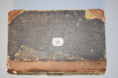
 Warrnambool and District Historical Society Inc.
Letter Book 4, 1901, 1908
This letter book has letters, invoices, sketch maps and plans and dates from 1908 to 1910. It came from the office of John William Crawley Junior, an engineer, architect and surveyor in private practice in Warrnambool and also the official engineer of the Shire of Warrnambool from 1895 to 1935. His father, brother and son were also engineers and worked in that capacity or as the Shire Secretary for the Shire of Warrnambool, with the Crawley family members recording a total of 132 years of service to the Shire. The letter book was passed on to John Crawley’s son, Rolf, Engineer for the Shire of Warrnambool from 1935 to 1968. The letter book then came into the possession of Michael Hand who took over the private surveying business of Rolf Crawley in Warrnambool and the Warrnambool and District Historical Society has acquired the letter book, one of several Crawley ledgers, from the Michael Hand estate. This letter book is of considerable significance as it contains maps, plans, sketches and written information on the work of John William Crawley, the engineer for the Shire of Warrnambool for 40 years. This is a black-covered letter book with copies of letters and field maps and plans and an alphabetical listing at the front. Some of the letters are invoices for work carried out. The leather section of the front cover has been almost completely torn away and the binding is mended with adhesive tape. There are some torn pages. The front page has a signature and a mauve stamp. ‘Letter Book’ ‘J.Wm. Crawley (Private)’ ‘ Rolf L. Crawley, Civil Engineer, Drainage and Water Supply Engineer, Licensed Surveyor, Registered Architect, Warrnambool’ ‘4’ rolf crawley, warrnambool, john william crawley, junior, warrnambool, history of warrnambool -
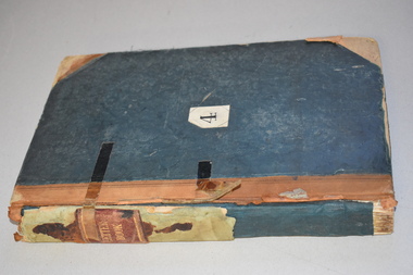
 Warrnambool and District Historical Society Inc.
Letter book 5, 1910
This letter book has letters, invoices and sketch maps and dates from 1910 to 1914. It came from the office of John William Crawley, Junior, an engineer, surveyor and architect in private practice in Warrnambool and also the official engineer for the Shire of Warrnambool from 1895 to 1935. His father, brother and son were also engineers and worked in that capacity or as the Shire Secretary for the Shire of Warrnambool, with the Crawley family recording a total of 132 years of service to the Shire. The letter book was passed on to John Crawley’s son, Rolf, engineer for the Shire of Warrnambool from 1935 to 1968. The letter book then came into the possession of Michael Hand who took over the private surveying business of Rolf Crawley in Warrnambool and the Warrnambool and District Historical Society has acquired the letter book, one of several Crawley ledgers, from the estate of Michael Hand.This letter book is of considerable significance as it contains maps, plans, sketches and written information, the work of John William Crawley, Junior, the Shire of Warrnambool engineer for 40 years. It will be very useful for research purposes. This is a brown-covered letter book of 750 pages with a mottled blue inside lining. The pages contain an alphabetical index and copies of handwritten letters and sketch maps and plans. There is one loose letter dated 1937. The pages are somewhat stained and the spine on the cover has been torn away. There is a mauve stamp on the first page. ‘5’ ‘Rolf L. Crawley, Civil Engineer, Drainage and Water Supply Engineer, Licensed Surveyor, Registered Architect, Warrnambool’ rolf crawley, warrnambool, john william crawley, junior, warrnambool