Showing 540 items matching " first survey"
-
 Bendigo Military Museum
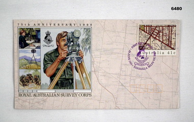
Postcard - 75th Anniversary Royal Australian Survey Corps First Day Cover 1990, Australia Post, 29 June 1990
... 75th Anniversary Royal Australian Survey Corps First Day Cover 1990...75th Anniversary Royal Australian Survey Corps First Day Cover 1990...This envelope was specifically produced for the 75th Anniversary of the Royal Australian Survey Corps. This First Day cover envelope was stamped at the Bonegilla Military Post Office on 29 June 1990 in preparation for the Corps birthday on 1 July. ...Royal Australian Survey Corps 75th Anniversary First Day Cover Envelope. The Postal Stamp is stamped with a Survey Corps badge in purple (the Corps Colour) " First day of Issue, Bonegilla Military Post Office 29 June 1990. ...The rear of the envelope contains a short history and role of the Royal Australian Survey Corps. 75th Anniversary Royal Australian Survey Corps First Day Cover 1990 Postcard 75th Anniversary Royal Australian Survey Corps First Day Cover 1990 Australia Post ...This envelope was specifically produced for the 75th Anniversary of the Royal Australian Survey Corps. This First Day cover envelope was stamped at the Bonegilla Military Post Office on 29 June 1990 in preparation for the Corps birthday on 1 July. The Envelope was stamped in Purple the Survey Corps Colour as apposed to normally being stamped in Black. The School of Military Survey was located at Bonegilla Victoria adjacent to Lake Hume reservoir. The envelope was designed by Lynette Brown from the Australia Post Graphic Design Studio utilising illustrations produced by Brian Clinton, Melbourne.Royal Australian Survey Corps 75th Anniversary First Day Cover Envelope. The Postal Stamp is stamped with a Survey Corps badge in purple (the Corps Colour) " First day of Issue, Bonegilla Military Post Office 29 June 1990. The 41cent stamp is a map extract. The envelope contains one large and three small graphics of Royal Australian Survey Corps activities and includes a Survey Corps Badge and Logo. The rear of the envelope contains a short history and role of the Royal Australian Survey Corps.royal australian survey corps, rasvy, fortuna, army survey regiment, army svy regt, asr -
 Bayside Gallery - Bayside City Council Art & Heritage Collection
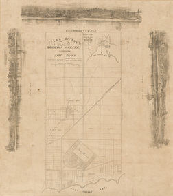
Map, H.B. Foot, Plan of the Brighton Estate containing 5120 acres, first special survey at Port Phillip, c. 1842
... Plan of the Brighton Estate containing 5120 acres, first special survey at Port Phillip...Their Brighton Estate was first surveyed by T. S. Townsend in May 1841 and was re-surveyed by Robert Hoddle. ...Their Brighton Estate was first surveyed by T. S. Townsend in May 1841 and was re-surveyed by Robert Hoddle. ...This plan records the Brighton Estate, also known as Dendy's Special Survey. In 1840 Henry Dendy, a farmer in Surrey, England acquired a "Special Survey" from the Commissioners for Land and Emigration which gave him the right to choose land in Port Phillip for the low price of £1 per acre for 5120 acres. Dendy appointed Jonathan Binns Were, as his agent, who later became a partner. Together, Dendy and Were decided on an area 5 miles south from Melbourne, bounded by North Road, East Boundary Road, South Road and to the west by Port Phillip Bay. Their Brighton Estate was first surveyed by T. S. Townsend in May 1841 and was re-surveyed by Robert Hoddle. Dendy and Were were making plans to sell the land and advertised a 30-guinea prize for the best subdivision which was to be divided into a village, marine residences, suburban and cultivation allotments, with the remainder being divided into country sections. The competition was won by H.B. Foot, who planned the village around a reserve and crescents and a 'green belt' forming the town boundary. brighton estate, dendy's special survey, special survey, henry dendy, jonathan binns were, w.b. were, survey, plan, map, brighton, george ward cole, baker's lithographer, hibernian, subdivision, town planning, cartographic material, h.b. foot -
 Bendigo Historical Society Inc.
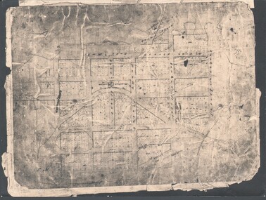
Photograph - WES HARRY COLLECTION: TOWNSHIP OF SANDHURST, 1854
... ...first survey...PLACE Bendigo first survey Sandhurst First Survey Bendigo Creek Photograph of the Parish Plan of the Township of Sandhurst in 1854. ...Photograph of the Parish Plan of the Township of Sandhurst in 1854. It covers the area of the CBD from Mitchell (not named) to Bernad Streets and from the Bendigo Creek to Mollison St. (other than Pall Mall and McRae streets, none of these parallel streets are named)place, bendigo, first survey, sandhurst, first survey, bendigo creek -
 Moorabbin Air Museum
Book (Item) - Flight First Principles - a general survey of fundamentals of aviation by Wright Smiley and Martin
... Flight First Principles - a general survey of fundamentals of aviation by Wright Smiley and Martin...Moorabbin Air Museum Moorabbin Airport 12 First Street Moorabbin melbourne Book Flight First Principles - a general survey of fundamentals of aviation by Wright Smiley and Martin ... -
 Kew Historical Society Inc
Photograph - Digital Photograph, Robert Baker, Grave of George Wharton, Boroondara General Cemetery, 2013
... George Wharton created the first survey of Kew and was elected the Municipality's first Chairman in 1861....George Wharton created the first survey of Kew and was elected the Municipality's first Chairman in 1861. ...The Victorian-era architect George Wharton, the initial surveyor of Kew. In 1866, he designed and had built Fernhurst in Studley Park, the house a prominent landmark. He resided there until his death, aged 69, on 26 November 1891. He was buried on 27 November in Grave 1520, Church of England Compartment B, Boroondara General Cemetery. Fernhurst Grove is named after his house, which was demolished in 1979.Born digital image of the grave and headstone of the architect George Wharton in the Boroondara General (Kew) Cemetery, 2013. George Wharton created the first survey of Kew and was elected the Municipality's first Chairman in 1861.victorian architects - george wharton, chairmen of kew (vic) - george wharton, boroondara general (kew) cemetery -
 Lorne Historical Society
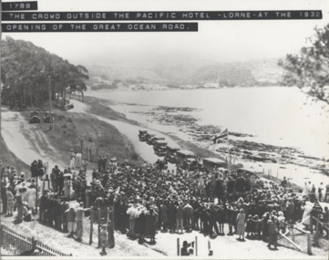
Photograph, Offical Opening Celebrations at Pacific Hotel Lorne 26th November 1932
... The Great Ocean Road was officially declared open on 26th November 1932 at a ceremony near Lorne's Grand Pacific Hotel, the site where the first survey peg for the road was hammered into the ground 14 years before. ...Lorne Historical Society Lorne Community House Mountjoy Parade Lorne great-ocean-road Opening Ceremony: Lorne Pacific Hotel: 26/11/1932 The Great Ocean Road was officially declared open on 26th November 1932 at a ceremony near Lorne's Grand Pacific Hotel, the site where the first survey peg for the road was hammered into the ground 14 years before. ...The Great Ocean Road was officially declared open on 26th November 1932 at a ceremony near Lorne's Grand Pacific Hotel, the site where the first survey peg for the road was hammered into the ground 14 years before. opening ceremony: lorne pacific hotel: 26/11/1932 -
 Federation University Historical Collection
Booklet, Waller & Chester, City of Ballarat, 09/1970
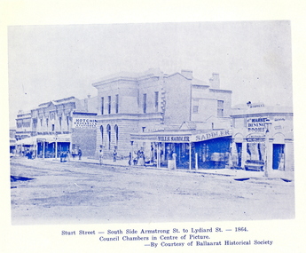
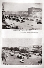
... It includes a City of Ballarat Logo, meeting agenda, and images of Sturt Street, central portion of the City, and the first survey of the Ballarat Township (1852)....It includes a City of Ballarat Logo, meeting agenda, and images of Sturt Street, central portion of the City, and the first survey of the Ballarat Township (1852). City of Ballarat Booklet Waller & Chester ...Ballarat became a city in 1870. The special centenary meeting was held on Wednesday 9 September 1970Large white soft covered booklet including the notice programme for the centenary meeting of the City of Ballarat. It includes a City of Ballarat Logo, meeting agenda, and images of Sturt Street, central portion of the City, and the first survey of the Ballarat Township (1852).ballarat, council, centenary, james oddie, ballarat east, ballarat town hall, muncipal, kenneth webb, town clerks, urquhart's survey -
Lakes Entrance Historical Society
Map - Bullumwaal c1900, 1985
... Based on the first survey of the township map drawn on from memory by Syd Hibbins...Lakes Entrance Historical Society 4 Marine Parade Lakes Entrance gippsland Based on the first survey of the township map drawn on from memory by Syd Hibbins Roads and Streets Mines and Mining Townships Waterways landowners Township map shows landowners, roads, Boggy Creek, mines. ...Based on the first survey of the township map drawn on from memory by Syd HibbinsTownship map shows landowners, roads, Boggy Creek, mines.roads and streets, mines and mining, townships, waterways, landowners -
 Whitehorse Historical Society Inc.
Article - The Bulletin newsletter, The Bulletin Jun - Aug 2022, Our Burwood Village, June 2022
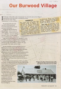
... An article about the first settlement surveyed in 1858 in the Burwood area known as Ballyshanassy. ...An article about the first settlement surveyed in 1858 in the Burwood area known as Ballyshanassy. ...An article about the first settlement surveyed in 1858 in the Burwood area known as Ballyshanassy. It later became Norwood and finally Burwood in 1879.An article about the first settlement surveyed in 1858 in the Burwood area known as Ballyshanassy. It later became Norwood and finally Burwood in 1879.An article about the first settlement surveyed in 1858 in the Burwood area known as Ballyshanassy. It later became Norwood and finally Burwood in 1879.ballyshanassy, albers ernest, boundary road burwood east, dempsey -
 Orbost & District Historical Society
book, Yarrawonga Chronicle, From Ballanda to 1968; the story of Yarrawonga, October 1968
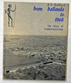
... This book was published as part of the "Back to Yarrawonga" celebrations in October 1968 and the centenary of the First Survey of the Township of Yarrawonga....Orbost & District Historical Society Ruskin Street Orbost gippsland This book was published as part of the "Back to Yarrawonga" celebrations in October 1968 and the centenary of the First Survey of the Township of Yarrawonga. This is a useful reference tool on the history of Yarrawonga. ...This book was published as part of the "Back to Yarrawonga" celebrations in October 1968 and the centenary of the First Survey of the Township of Yarrawonga.This is a useful reference tool on the history of Yarrawonga.A 90 pp paper back book titled, "From Ballanda to 1968; The Story of Yarrawonga". On the front cover on a glossy grey background is a photograph of Yarrawonga. The title is in blue print.yarrawonga-history -
 Federation University Historical Collection
Booklet, John Fraser, City of Ballarat 1856-1956, 1956
... It includes a notice paper for a special meeting of Council, minutes of the Municipal Council of Ballaarat, first meeting, and images of the first survey of the Ballarat Township (1852), Ballarat in 1854, Central Ballarat in 1956, N. ...Barker Library (top floor) Mount Helen goldfields The Ballarat Municipality was established in 1856. ballarat council ballarat east ballaarat munipality ballarat townscape Sturt Street ballarat survey yarrowee paroompi parmoompi diggings Cream covered booklet covering a special meeting held to commemorate the 100th anniversary of the City of Ballarat Council. It includes a notice paper for a special meeting of Council, minutes of the Municipal Council of Ballaarat, first meeting, and images of the first survey of the Ballarat Township (1852), Ballarat in 1854, Central Ballarat in 1956, N. ...The Ballarat Municipality was established in 1856.Cream covered booklet covering a special meeting held to commemorate the 100th anniversary of the City of Ballarat Council. It includes a notice paper for a special meeting of Council, minutes of the Municipal Council of Ballaarat, first meeting, and images of the first survey of the Ballarat Township (1852), Ballarat in 1854, Central Ballarat in 1956, N. T. Callow and James Oddie. ballarat, council, ballarat east, ballaarat, munipality, ballarat townscape, sturt street, ballarat survey, yarrowee, paroompi, parmoompi, diggings -
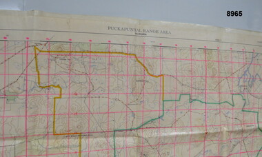 Bendigo Military Museum
Map - MAP - PUCKAPUNYAL RANGE AREA, Royal Australian Survey Corps, Bendigo, 1958
... Military Survey, First Edition 1958....”Puckapunyal Range Area Military Survey Australia 1.25,000. First Edition”...Military Survey, First Edition 1958. Passchendaele Barracks Trust PBT? ...Military Survey, First Edition 1958.Large waterproof map of Puckapunyal Range area compiled by the Royal Australian Survey Corps in 1958 detailing Reference locations in and around Puckapunyal area.”Puckapunyal Range Area Military Survey Australia 1.25,000. First Edition”passchendaele barracks trust, pbt?, military map -
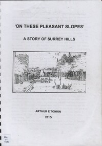 Surrey Hills Historical Society Collection
Book, On these pleasant slope's: a story of Surrey Hills, 2015
... Includes: Topographical maps, first Elgar Survey. First Wesleyan Church in Surrey Hills. ...Includes: Topographical maps, first Elgar Survey. First Wesleyan Church in Surrey Hills. ...Sourced via conversations with those interested in Surrey Hills History. Including Alan Holt, Jack McLean, Frank Bamford, Jocelyn Hall. Includes: Topographical maps, first Elgar Survey. First Wesleyan Church in Surrey Hills. Bibliography on P.50 (last numbered page) Provides a chronological history of Surrey Hills. Includes: First settlers, location, early land sales, commerce and trade.Provides a chronological history of Surrey Hills. Includes: First settlers, location, early land sales, commerce and trade.Back of Title page: To the Surrey Hills Historical / Arthur E. Tonkinfreehold investment and banking company, windsor park estate, (mr) dennis delany, mont albert village, surrey hills - history, royal hotel, surrey hills, humberstone's hotel, chatham state school, holy trinity church, lydswood, lugano, (mr) john butler maling, (mr) john hanlon knipe, mont albert primary school, (mr) james sneddon, (mr) arthur tonkin -
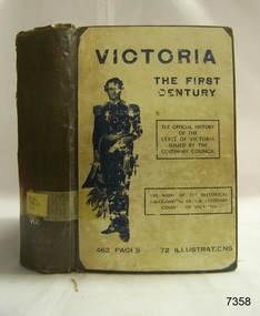 Flagstaff Hill Maritime Museum and Village
Book, Victoria The First Century
... Victoria The First Century A Historical Survey Compiled by The Historical Sub-committee of The Centenary Celebrations Council Publisher: Robertson & Mullens Date: 1934 ...Flagstaff Hill Maritime Museum and Village 89 Merri Street Warrnambool great-ocean-road Warrnambool Shipwrecked-coast Flagstaff-Hill Flagstaff-Hill-Maritime-Museum Maritime-Museum Shipwreck-coast Flagstaff-Hill-Maritime-Village Shipwrecked-artefact Book Warrnambool Library The Historical Sub-committee of The Centenary Celebrations Council Victoria The First Century Label on spine with typed text R.A. 994.5 VIC Victoria The First Century A Historical Survey Compiled by The Historical Sub-committee of The Centenary Celebrations Council Publisher: Robertson & Mullens Date: 1934 Victoria The First Century Book ...Victoria The First Century A Historical Survey Compiled by The Historical Sub-committee of The Centenary Celebrations Council Publisher: Robertson & Mullens Date: 1934 Label on spine with typed text R.A. 994.5 VIC warrnambool, shipwrecked-coast, flagstaff-hill, flagstaff-hill-maritime-museum, maritime-museum, shipwreck-coast, flagstaff-hill-maritime-village, shipwrecked-artefact, book, warrnambool library, the historical sub-committee of the centenary celebrations council, victoria the first century -
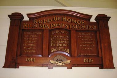 Coal Creek Community Park & Museum
Honour Roll, Kilcunda Road School Honor Roll
... On the west side of the intersection of the Bena - Kongwak and Buchanans' Roads is a brass plaque on a granite boulder with the following inscription TO COMMEMORATE THE DISTRICT OF KILCUNDA ROAD First Surveyed 1879. This is the site of the KILCUNDA ROAD UNITING CHURCH 1911 to 1966. ...On the west side of the intersection of the Bena - Kongwak and Buchanans' Roads is a brass plaque on a granite boulder with the following inscription TO COMMEMORATE THE DISTRICT OF KILCUNDA ROAD First Surveyed 1879. This is the site of the KILCUNDA ROAD UNITING CHURCH 1911 to 1966. ...This WWI Honor Roll was originally displayed in the Kilcunda Road State School (no.3337), which was located at the north east corner of the intersection of the Bena - Kongwak and Buchanans' Roads, Bena, Victoria, 3946. The school was located amongst the cypress trees at 645 Bena-Kongwak Road. The school was relocated in 2008 to the Coal Creek Community Park and Museum, 12 Silkstone Road, Korumburra, 3950 to become the Masonic Lodge building in the park display. On the west side of the intersection of the Bena - Kongwak and Buchanans' Roads is a brass plaque on a granite boulder with the following inscription TO COMMEMORATE THE DISTRICT OF KILCUNDA ROAD First Surveyed 1879. This is the site of the KILCUNDA ROAD UNITING CHURCH 1911 to 1966. Diagonally opposite at 645 Bena-Kongwak Road was the site of the KILCUNDA ROAD PRIMARY SCHOOL No: 3337, 1902 to 1975. Erected by The School Mother’s Club continuing as The Kilcunda Road Social Club 2008. One of the few remaining historic items from Kilcunda Road settlement.Honour roll of varnished wood, with three panels, an undulating shaped pediment, plain columns at sides, painted gold text and the Australian Imperial Forces insignia on base.Roll of Honor, Kilcunda Road State School. In Honor of Old Scholars of this school who served the Empire in the Great War, 1914-1919, Australian Imperial Force. (X) These made the supreme sacrifice. Sister J.E. Turner , E.N. Barge, E.F. Binding (X), E.H. Bunn, D. James (X), W.James, A. James (X), R. H. James, A.G. Rose (X), C.W. Stanlake, G. Wuchatsch, R. Wuchatsch, T.E. Young kilcunda road, honour roll, state school no.3337., wwi -
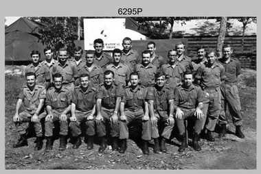
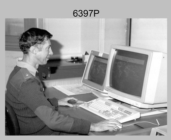 Bendigo Military Museum
Photograph - MAJ Bob Williams – Technical Award Recipient, Army Survey Regiment, Fortuna, Bendigo, 1990
... At the time he had completed PhD studies at the Australian Defence Academy and was the first Survey Corps officer to complete studies at this advanced level. ...At the time he had completed PhD studies at the Australian Defence Academy and was the first Survey Corps officer to complete studies at this advanced level. ...In 1990 MAJ Bob Williams was the OC of Technical Development Cell. He won first prize for his entry ‘Innovations in Cartographic Communication’ in the individual category at the 2nd Australian Institute of Cartographers and BHP Engineering Technology Research and Development Awards. The award was announced at the 1990 Australian Cartographic Conference in Darwin where MAJ Williams presented his entry. At the time he had completed PhD studies at the Australian Defence Academy and was the first Survey Corps officer to complete studies at this advanced level. Also, in 1990 the Royal Australian Survey Corps’ meritorious achievements were formally recognised by the Senate of the Australian Parliament in a Notice of Motion on 31st of May 1990. The Royal Australian Survey Corps also featured in the issue of a commemorative stamped envelope issued by Australia Post. These achievements are covered in more detail in page 147 of Valerie Lovejoy’s book 'Mapmakers of Fortuna – A history of the Army Survey Regiment’ ISBN: 0-646-42120-4. This photograph of MAJ Bob Williams was taken in Technical Development Cell at the Army Survey Regiment, Fortuna, Bendigo in 1990. The black & white photograph was printed on photographic paper and is part of the Army Survey Regiment’s Collection. The photograph was scanned at 300 dpi. .1) - Photo, black & white, 1990. MAJ Bob Williams – Technology Award Recipient.1P – annotated in red pen ‘MAJ Williams Technology Awards’royal australian survey corps, rasvy, army survey regiment, army svy regt, fortuna, asr -
 Bendigo Historical Society Inc.
Document - RESEARCH PAPERS: THOMAS WILKINSON PINNIGER, 1828
... With a team of 4 he conducted the first geodetic* survey of Victoria. He became the Government Surveyor for Bendigo in 1853 and in 1854 he laid out the plans for the town of Broadford. ...With a team of 4 he conducted the first geodetic* survey of Victoria. He became the Government Surveyor for Bendigo in 1853 and in 1854 he laid out the plans for the town of Broadford. ...Thomas Pinniger (1828-1927) was born in England and emigrated to New Zealand before coming to Australia in 1852. With a team of 4 he conducted the first geodetic* survey of Victoria. He became the Government Surveyor for Bendigo in 1853 and in 1854 he laid out the plans for the town of Broadford. His son George, became the Victorian Surveyor General 1925-6. * Large scale mapping based on global measurements of large land masses. It allows corrections for the curvature of the earth.Document detailing the history of district surveyor Thomas Wilkinson Pinniger and his family history.thomas pinninger, family history -
 Ballarat Heritage Services
Photograph - Photograph - Colour, Clare Gervasoni, Koroit Post Office, 2015, 21/12/2015
... (https://en.wikipedia.org/wiki/Koroit, accessed 21 December 2016) Koroit was first surveyed as a township in 1847. Around the 1850 the district had the highest population of Irish immigrants in rural Australia. ...(https://en.wikipedia.org/wiki/Koroit, accessed 21 December 2016) Koroit was first surveyed as a township in 1847. Around the 1850 the district had the highest population of Irish immigrants in rural Australia. ...The town borrows its name from the Koroitch Gundidj people who occupied the area prior to European settlement. (https://en.wikipedia.org/wiki/Koroit, accessed 21 December 2016) Koroit was first surveyed as a township in 1847. Around the 1850 the district had the highest population of Irish immigrants in rural Australia. The Koroit Post Office was designed by architect and engineer John Mason of Port Fairy. (Moyne Shire Heritage Study 2006 Stage 2, Volume 2: Environmental History, Prepared for Moyne Shire Council Helen Doyle in association with Context Pty Ltd, 2006.) Rosebrook Bridge, Rosebrook (1853; replaced) Post Office buildings, Bank Street, Port Fairy (c.1857) The author Henry Handel Richardson lived in the Koroit Post Office as a child after her family moved to Koroit in 1878. Remembering Koroit from her youth, the third volume in her The Fortunes of Richard Mahony trilogy is set in the town. When the author was six, her father Walter died in Koroit on 1 August 1879 and was buried at the Koroit cemetery. (https://en.wikipedia.org/wiki/Koroit, accessed 21 December 2016) In 1878 Mary Richardson was appointed postmistress of the Koroit Post Office at a salary of 72 pounds with free quarters, firewood and kerosene. She lived at the back of the Post Office. (From a Green and Pleasant Land by H. McCorkell and P. Yule.) Photographs showing the bluestone Koroit Post Office, phone box and postbox. It is located at 99 Commercial Road, Koroit. "Historic Area Statement of Significance: The significance of Koroit derives from its role as the urban centre of one of the most concentrated Irish Roman Catholic rural districts in Australia, noted for its mixed livestock and cropping argicultural patterns. This is reflected in two separate and distinctive areas in the town - the administrative/commercial area and the church precinct. The administrative and commercial area (focussing on the Boundary-Commercial Road/High Street intersection and the Koroit Hotel) consists of a number of significant public buildings and leads to a street of relatively intact humble shopfronts and kerbline verandahs, visually punctuated by opposing bank facades. The church precinct is dominated by a group of Catholic buildings larger in scale and more complete in range than those in any comparably sized Victorian town." http://vhd.heritagecouncil.vic.gov.au/places/69338#sthash.ELLuSMvg.dpuf, accessed 21 December 2016."koroit, post office, phone box, payphone, bluestone, henry handel richardson, koroit post office -
 Bendigo Historical Society Inc.
Memorabilia - WOODEN BOX KNOWN AS THE 'VIOLET BOX', BENDIGO SURVEY OFFICE MR. BLACK
... Survey Office where the Pinniger family lived from 1878 to 1890. The box originally belonged to a Mr. Black, who with Grandfather (T.W. Pinniger) and the others, Messrs. Allen and Turton, did the first...Survey Office where the Pinniger family lived from 1878 to 1890. The box originally belonged to a Mr. Black, who with Grandfather (T.W. Pinniger) and the others, Messrs. Allen and Turton, did the first ...Wooden box inlaid on top and front with hard white material (unknown) printed with sprays of violets. Box has metal decoration: images of violets surrounded by metal edging, ornate corner scrolls. Written on piece of paper stuck inside box: 'The Violet Box. This box is a relic of Bendigo Survey Office where the Pinniger family lived from 1878 to 1890. The box originally belonged to a Mr. Black, who with Grandfather (T.W. Pinniger) and the others, Messrs. Allen and Turton, did the first geodetic survey of Victoria. To be given to Bendigo Historical Society' Newspaper article (Bendigo Advertiser July 16, 2009, by Jim Evans) included in enclosure relates to the 'Violet Box', and other early surveyors such as Richard Larritt.bendigo, sandhurst, geodetic, survey, pinniger, black -
 Eltham District Historical Society Inc
Folder, Unpublished collection of Eltham State School No. 209 items, 1856-1995 by Harry Gilham (EDHS)
... It was prepared to help celebrate the 140th year of the school's existence on its original land grant of 1856, which appeared on the first surveyed land for the formation of the Town of Eltham, in the Parish of Nillumbik, County of Evelyn, granted by the then Government of New South Wales. ...It was prepared to help celebrate the 140th year of the school's existence on its original land grant of 1856, which appeared on the first surveyed land for the formation of the Town of Eltham, in the Parish of Nillumbik, County of Evelyn, granted by the then Government of New South Wales. ...Contents 1. Draft chronology - Eltham Primary School Chronology 1856-1995; Harry Gilham (EDHS) 1995 127 pages, A4 photocopies This collection of memorabilia has a focus on the Eltham State School No. 209. It was prepared to help celebrate the 140th year of the school's existence on its original land grant of 1856, which appeared on the first surveyed land for the formation of the Town of Eltham, in the Parish of Nillumbik, County of Evelyn, granted by the then Government of New South Wales. It is inscribed in Harry Gilham's writing on page 1 - "For Eltham P.S Chronology 209 - 150th Anniv. book; Harry Gilham Collection; Unpublished" and stamped "Eltham District Historical Society" Pages 3 and 4 missing. This manuscript was a major source reference for the book "We Did Open A School In Little Eltham; Eltham Primary School 209, 1856-2006, A History" Source references from Inspector's Register of State Schools; photocopies held by EDHS in A3 binders 2. Renovation of Eltham Primary School Residence; Application of a Grant from National Estate Grants program, 17 April 1989 10 pages A4 photocopy 3. Wayfinding In The Environment; The role of aesthetics research in participatory planning design by Victoria Sharp for the School of Environmental Planning, The University of Melbourne, February 1987 4 pages, A4 photocopy extracts copied include: Synopsis Spefic Design Concerns p37 (relative to Eltham Gateway) Summary p38 4. File Record, State School No 209 - Eltham; National Trust of Australia File No B3260; 29 March 2000 1 page A4 5. Notes by Harry Gilham concerning Eltham State School No 209 1 page handwritten lined pad sheet 6. Notes by Harry Gilham concerning Eltham State School No 209 and feedback on 150th Anniversary book 1 page, A4 green 144 A4 pages As noted150th anniversary, chronology, eltham gateway, eltham primary school, eltham state school, harry gilham, national trust of australia, planning, renovation, school residence, state school no. 209, victoria sharp -
 Robin Boyd Foundation
Document - Manuscript, Robin Boyd, The Crisis in Architecture
... Boyd quickly surveys the first generation of modern architecture. ...Robin Boyd Foundation 290 Walsh Street South Yarra melbourne Boyd quickly surveys the first generation of modern architecture. ...Boyd quickly surveys the first generation of modern architecture. The talk then concentrates on where modern architecture turned next: the "search for new richness on the surface and a search for new excitement in form". He focuses on the second generation of modern architects: Edward Stone (surface search) and Eero Saarinen (excitiement search). Several of their influential buildings are critiqued by Boyd. This document was the basis for a lecture titled "The Contemporary Situation in Architecture" (item D521, with edits).Typewritten, quarto, 16 pagesinternational style, mies van der rohe, frank lloyd wright, edward stone, eero saarinen, le courbuier, felix candela, matthew novicki, eduardo catalano, hugh stubbins, raymond and rado, jorn utzon, toro-ferrer -
 Orbost & District Historical Society
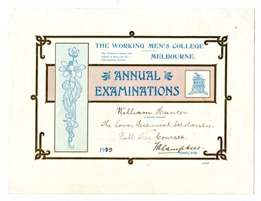
certificates, 1909, 1911, 1912
... The certificates include two first prizes for surveying, a technical scholarship for full day courses and a certificate for Applied Mechanics. ...The certificates include two first prizes for surveying, a technical scholarship for full day courses and a certificate for Applied Mechanics. ...These four certificates belonged to William Hunter. William Hunter (1893-1971) was a resident of Tatura and Mallacoota. He was a soldier, surveyor and amateur naturalist. The certificates include two first prizes for surveying, a technical scholarship for full day courses and a certificate for Applied Mechanics. William received his Surveying Certificate in April 1916. In June 1887, the Working Men's College opened after Francis Ormond, a noted Victorian philanthropist and member of parliament, suggested that a technical institute be built in Melbourne, offering further education for working men and women. He had offered to match the sum raised through public subscription if the government could provide a site for the College. William Hunter made valuable contributions to our knowledge of far East Gippsland plants. His records were meticulous. These certificates are part of his history.Four card certificates of merit for "Annual Examinations" from the Working Men's College, The Technical College and School of Mines for the Metropolitan District.All four certificates awarded to "William Hunter" and signed by Mordaunt Arundel Hall (accountant & chief clerk WMC) as the Acting Director.hunter-william-surveyor -
 Robin Boyd Foundation
Document - Manuscript, Robin Boyd, The Contemporary Situation in Architecture
... Boyd quickly surveys the first generation of modern architecture. ...Robin Boyd Foundation 290 Walsh Street South Yarra melbourne Boyd quickly surveys the first generation of modern architecture. ...Boyd quickly surveys the first generation of modern architecture. The talk then concentrates on where modern architecture turned next: "the search for new richness on the surface and a search for new excitement in form". Boyd focuses on the second generation of modern architects: Edward Stone (surface search) and Eero Saarinen (excitiement search). Several of their influential buildings are critiqued by Boyd. This document includes the whole of the typed manuscript titled "The Crisis in Architecture" (item D522, with edits), and includes two handwritten pages at the start and ends with a handwritten statement about "architectural poetry". The text and annotations indicate this was a lecture with slides.Typewritten and handwritten sections, an amalgamation of documents, quarto, 18 pagesUnderlinings, pencil additions, indications for slidesinternational style, mies van der rohe, frank lloyd wright, edward stone, eero saarinen, le courbuier, felix candela, matthew novicki, eduardo catalano, hugh stubbins, raymond and rado, jorn utzon, toro-ferrer -
 Bendigo Military Museum
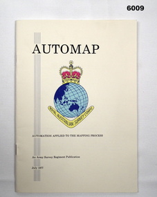
Pamphlet - AUTOMAP - Automation Applied to the Mapping Process, Major Sam Thompson US Army Corps of Engineers, 01.07.1977
... This pamphlet produced by Major Sam Thompson US Army Engineer Corps on exchange to Australia was published as a guide to AUTOMAP 1, the Army Survey Regiment’s first computer-based map production system. ...Bendigo Military Museum 37 - 39 Pall Mall Bendigo goldfields This pamphlet produced by Major Sam Thompson US Army Engineer Corps on exchange to Australia was published as a guide to AUTOMAP 1, the Army Survey Regiment’s first computer-based map production system. ...This pamphlet produced by Major Sam Thompson US Army Engineer Corps on exchange to Australia was published as a guide to AUTOMAP 1, the Army Survey Regiment’s first computer-based map production system. It examined how automation had changed the compilation and drafting phases of the map production process. It attempted to present in a light-hearty story telling style, short and clear description of each AUTOMAP 1 sub-system with photos of staff and equipment, diagrams and humorous cartoons. The cartoonist is unknown. The pamphlet was printed at the Army Survey Regiment, Bendigo Army Survey Regiment pamphlet comprises a manilla card cover printed in colour with 24 pages with photographs in black and white; and descriptions, diagrams, and cartoons printed in colour. It is bounded by two staples on its spine. The coloured pages have been scanned at 300 dpi and are stored on a USB Digital Storage Device. The page images have been converted into a video (.mp4) format and also stored on the USB. The video is 1.3Mb in size and runs for 1.3 minutes.royal australian survey corps, rasvy, fortuna, army survey regiment, army svy regt, asr -
 Eltham District Historical Society Inc
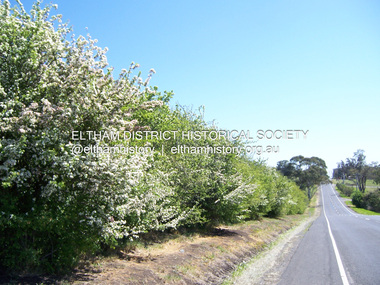
Photograph - Digital Photograph, Marguerite Marshall, Hawthorn hedges, Eltham-Yarra Glen Road, Kangaroo Ground, 3 October 2006
... That is why they refused to release any of it ‘for local roads to follow easier grades as was the case in surrounding districts where roads generally followed ridgelines or streams’.3 Instead the roads were built in accordance with the magnetic bearings of their first survey in 1847 whether that suited the steep topography or not. ...That is why they refused to release any of it ‘for local roads to follow easier grades as was the case in surrounding districts where roads generally followed ridgelines or streams’.3 Instead the roads were built in accordance with the magnetic bearings of their first survey in 1847 whether that suited the steep topography or not. ...Hawthorn hedges are important reminders of Kangaroo Ground's Scottish heritage. They are Registered on the Victorian Heritage Register. They are "historically significant because the planting of hawthorn hedges reflects the adoption of Eurorpean farming techniques by the Kangaroo Ground population in the period following settlement and because the grid pattern of paddocks that the Hawthorn hedges define is very different to today's farm landscapes." Covered under Heritage Overlay, Nillumbik Planning Scheme. Published: Nillumbik Now and Then / Marguerite Marshall 2008; photographs Alan King with Marguerite Marshall.; p21 Hawthorn hedges bordering Kangaroo Ground’s gently rolling farmlands are important reminders of its Scottish heritage and are rare so close to Melbourne.1 As early as the 1840s newly arrived farmers from Scotland planted hawthorn hedges around their properties, to protect crops from the numerous kangaroos and wallabies. Many of these hedges survive today. These farmers had the good fortune to settle some of the most fertile land available for cropping in the Colony of Victoria. At that time the black volcanic soil could sustain an amazing two crops a year. By the mid 1850s, 500 acres (202ha) of wheat were growing in Kangaroo Ground. But the crops were threatened by kangaroos, which were so plentiful, that Surveyor-General, Robert Hoddle, named the district Kangaroo Ground in 1838. As post-and-rail fences proved inadequate barriers for the bounding kangaroos, the Scots planted hawthorn hedgerows as they had done in Scotland. Some also used the hedges to net birds, presumably for the table. Interestingly the farmers in the bordering townships of Panton Hill and Christmas Hills, did not plant hawthorn hedges around their properties. Perhaps it was because by the time they settled in the 1860s and 1870s most of the wildlife had been gunned down by residents.2 The canny Scots planted the hedges on public land outside their own farms, as the hedgerows could spread to about five yards (five m) in width. With this impenetrable barrier Kangaroo Ground’s industrious farmers flourished to gain the economic power that saw the Shire of Eltham governed from Kangaroo Ground for 79 years (1858-1937). The Scots jealously guarded their land, so hard to get in Scotland. That is why they refused to release any of it ‘for local roads to follow easier grades as was the case in surrounding districts where roads generally followed ridgelines or streams’.3 Instead the roads were built in accordance with the magnetic bearings of their first survey in 1847 whether that suited the steep topography or not. This could force traffic to diverge when wet through Greensborough and Diamond Creek. Until 1921, the Eltham-Yarra Glen Road beside Wellers Restaurant, ‘dipped down into the upper reaches of Stony Creek’.4 Later some corners were compulsorily cut for the increasing motor traffic. As late as the 1960s, corners were cut to form sweeping curves above and alongside the Kangaroo Ground Cemetery and opposite the Emergency Operations Centre. In the latter case, the farmers – understanding their hedgerows as important heritage – insisted upon their reinstatement to conform to the altered road alignment. Kangaroo Ground’s ancient manna gums also point to the district’s history and to that of the hedgerows. The Aboriginal people had transformed the original forests into grasslands with the fires they lit to attract kangaroos, (which the Scots were to exclude by planting hedgerows). But the Wurundjeri hunters left the gums (Eucalyptus vimminalis cygnetensis), on the grasslands as ‘stalking trees’ to hunt kangaroos. The hawthorn hedges in Kangaroo Ground were neglected for around 60 years from about the middle of the 20th century. Bushfires had created gaps and the hedgerows were not trimmed. Then in late 2005, local historian Mick Woiwod, formed a group to lobby the Nillumbik Shire to restore the hedges, which could last for many centuries. Some hedges in parts of Britain date back to AD 800.5 Although the original Scottish farmers have gone, the hedges are a reminder of when they flourished in the district, which has changed little in 150 years.This collection of almost 130 photos about places and people within the Shire of Nillumbik, an urban and rural municipality in Melbourne's north, contributes to an understanding of the history of the Shire. Published in 2008 immediately prior to the Black Saturday bushfires of February 7, 2009, it documents sites that were impacted, and in some cases destroyed by the fires. It includes photographs taken especially for the publication, creating a unique time capsule representing the Shire in the early 21st century. It remains the most recent comprehenesive publication devoted to the Shire's history connecting local residents to the past. nillumbik now and then (marshall-king) collection, eltham-yarra glen road, hawthorn hedgerow, kangaroo ground -
 Bendigo Military Museum
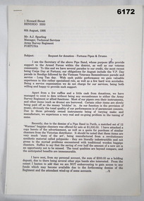
Memorabilia - Fortuna Pipes and Drums Request for Donation, PSJ Barker, Secretary Fortuna pipes and Drums, 06.08.1995
... Information about the Fortuna Pipes and Drums is also in Valerie Loyejoy's book " Mapmakers of Fortuna, A History of the Army Survey Regiment" ISBN 0-646-42120-4 and included in the Victorian Collection as item 6000. The Band was originally formed in 1993 from members of the local Masonic Lodge and first played for the Survey Corps Day Parade in 1994 after a request from the then RSM WO1 Phil Meagher. ...Information about the Fortuna Pipes and Drums is also in Valerie Loyejoy's book " Mapmakers of Fortuna, A History of the Army Survey Regiment" ISBN 0-646-42120-4 and included in the Victorian Collection as item 6000. The Band was originally formed in 1993 from members of the local Masonic Lodge and first played for the Survey Corps Day Parade in 1994 after a request from the then RSM WO1 Phil Meagher. ...This is a document requesting a donation for the Fortuna Pipes and Drums for the update of some of their equipment. The members of the band are shown and named in the accompanying photo. Information about the Fortuna Pipes and Drums is also in Valerie Loyejoy's book " Mapmakers of Fortuna, A History of the Army Survey Regiment" ISBN 0-646-42120-4 and included in the Victorian Collection as item 6000. The Band was originally formed in 1993 from members of the local Masonic Lodge and first played for the Survey Corps Day Parade in 1994 after a request from the then RSM WO1 Phil Meagher. The Army was able to provide the original "Black Watch" tartan kilts. Using an original Survey Corps Badge c. 1915 provided by former WO1 Keith "Aki" Barber, a number of replica metal Survey Corps theodolite badges were struck and used along with the purple Survey Corps lanyard by the band. The Fortuna Pipes and Drums continued to actively support the Army Survey Regiment until its disbandment in 1996.A 4 x Page letter, A4 Pages, Typed document, PhotocopyAddressed to Mr Tony Spurling, Manager Technical Services, Army Svy Regt, Fortunaroyal australian survey corps, rasvy, fortuna, army survey regiment, army svy regt, asr -
 Flagstaff Hill Maritime Museum and Village
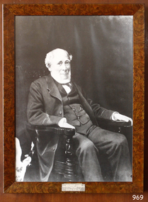
Photograph - Portrait, David Charles McArthur, Superintendent, Bank of Australasia 1867-1876
... (David's brother, Donald, moved from Sydney to Melbourne in 1836 with the first government survey team.) ABOUT THE BANK OF AUSTRALASIA In 1836 the Bank of Australasia was established in London by Royal Charter. ...(David's brother, Donald, moved from Sydney to Melbourne in 1836 with the first government survey team.) ABOUT THE BANK OF AUSTRALASIA In 1836 the Bank of Australasia was established in London by Royal Charter. ...The subject of this photograph, David Charteris McArthur, was the founding manager of the Bank of Australasia in Port Phillip (Melbourne). McArthur was born in 1808 in Gloucester, England, and educated in Scotland. He worked for an insurance firm in Edinburgh, where in 1835 he married Caroline, nee Wright. McArthur and his family party sailed from the U.K. to arrive in Sydney in October 1835, where he joined the Bank of Australasia when it opened in Sydney in December. McArthur sailed to Melbourne in August 1838 with 3000 pounds in coins, protected by armed guards and two bulldogs, to open the Melbourne branch of the Bank of Australasia. The branch grew quickly, servicing both private and government customers. He opened many branches in the goldfields during the 1850s. In 1862, he was appointed as general inspector of branches. He spent time with the bank in New Zealand. On his return to Melbourne, at age 57, he was put in charge of the entire bank. McArthur lived in the hills of Heidelberg, Melbourne. He was the first chairman of Associated Banks and was an advisor to politicians and merchants. He was retired in October 1876 by the London directors and given a free trip to London, an annuity and a seat on the bank’s Advisory Board. McArthur was active in the community, being a member of the Mechanics’ Institute, on the committee that advised Governor Hotham on the Colony’s finances, chairman of the Heidelberg Road Board, one of the original trustees of the Library of Victoria in 1853 and president of the trustees of the Public Library, Museums and National Gallery of Victoria in 1880-83. He was also on many other community organisations. He died in his home “Charterisville” in East Ivanhoe in 1887. He and Caroline had no children. The Melbourne branch of Australia and New Zealand Bank has a portrait of McArthur in its boardroom. St John's Church, Heidelberg, commemorates him with a stained-glass window entitled 'King David'. The McArthur Gallery in the National Gallery of Victoria is also named after him. (David's brother, Donald, moved from Sydney to Melbourne in 1836 with the first government survey team.) ABOUT THE BANK OF AUSTRALASIA In 1836 the Bank of Australasia was established in London by Royal Charter. In 1951 the bank merged with the Union Bank of Australia, to form ANZ Bank Limited. In 1970 it merged with the English, Scottish and Australian Bank to become Australia and New Zealand Banking Group Limited. Since that time the ANZ has acquired other banks and introduced Internet banking and mobile banking. BANK OF AUSTRALASIA IN WARRNAMBOOL The Bank of Australasia first opened in Warrnambool in July 1854 in a building on Merri Street. The manager was Mr Samuel Hannaford. The bank then purchased and moved to a stone building on the corner of Timor and Gibson Streets, previously owned by Cramond and Dickson and almost opposite the Examiner’s office. In January 1957 Mr W.H. Palmer became the new manager and was there until November 1869. The bank then built its own building on the corner of Timor and Kepler Streets in 1859. Mr Basil Spence, the teller, was appointed acting manager in 1869 and Mr H.B. Chomley was the next appointed manager, in April 1873 and was still manager in 1886. The municipality of Warrnambool first banked with the Bank of Australasia from 1856 to April 1857. David Charteris McArthur served as the founding manager of the Bank of Australasia. His leadership marked a significant chapter in Warrnambool's early commercial development. The municipality of Warrnambool relied on the Bank of Australasia as its official bank from 1856 until April 1857. This period is symbolised by a photograph of McArthur, which represents the origins of Warrnambool's commercial history and its early financial infrastructure.Photograph; portrait of David Charteris McArthur. Heavily retouched black and white print in plain brown varnished frame, behind glass, with plaque on lower edge and inscription lower left corner.Lower left corner "A-H 1-9". Engraved on plaque "DAVID CHARTERS MCARTHUR \ SUPERINTENDENT \ BANK OF AUSTRALASIA \ 1867-1876"flagstaff hill, warrnambool, shipwrecked-coast, flagstaff-hill, flagstaff-hill-maritime-museum, maritime-museum, shipwreck-coast, flagstaff-hill-maritime-village, bank of australasia, david charteris mcarthur, superintendent bank of australasia, colonial commerce, manager bank of australasia melbourne, colonial bank, warrnambool bank of australasia, shipwrecked coast, flagstaff hill maritime museum, maritime museum, shipwreck coast, flagstaff hill maritime village, great ocean road, boa, union bank, australia & new zealand bank, anz bank, david charters mcarthur, d c mcarthur -
 Bendigo Military Museum
Photograph - A Section, 1st Topographic Survey Troop, Nui Dat, Vietnam, 1969
... Johnston. The first Royal Australian Survey Corps troops arrived in South Vietnam on the 10th of June 1966. ...Johnston. The first Royal Australian Survey Corps troops arrived in South Vietnam on the 10th of June 1966. ...This is a photograph of A Section, 1st Topographic Survey Troop taken at Nui Dat, Vietnam in 1969. A nominal roll of personnel and their trade as of the 30th of September 1969, accompanies this photo. Their trades in this photo were as follows - Surveyors Topographic: WO1 Darby Munro, SGT Paddy Strunks, SGT Graeme Birrell, CPL Brian Knight, CPL Colin Laybutt, SPR Roderick Gilbert and SPR Rodney Offer. Draughtsmen Topographic: SGT Terrance Linz, CPL Robert Kay, SPR Peter Aukstinaitis, SPR Lloyd Patterson and SPR Ian Wark. Photographer Cartographic: CPL George Graham. Clerk Admin: CPL Oreste Biziak. Helioworker: CPL Geoffrey White, SPR Lance Percey. Cook AACC: PTE R. Johnston. The first Royal Australian Survey Corps troops arrived in South Vietnam on the 10th of June 1966. This was a detachment from 1st Topographic Survey Troop, which was to give cartographic support to the Australian Task Force. Their main tasks were to establish a Theatre Grid, map compilation and map revision. Engineer Survey Support in the camp and to the civil community and give assistance to the Cordon Search Missions by producing large scale plots from aerial photos with every house and fence etc plotted and then reproduce these by silk screening usually, within a 24-hour period. This support concluded with the withdrawal of Australian troops from Vietnam in 1972. For more information on the career of A Section’s OC MAJ Peter Constantine AM, refer to item 6159P or 6092P. He was the CO of the Army Survey Regiment from 1975 to 1976 and CO of the School of Military Survey (SMS) from 1976 to his retirement in January 1982. His memoirs of active duty in Vietnam ‘Surveyor - Printer Behind the Lines’ was published in 2022. 2IC CAPT Frank Thorogood SB St J’s career culminated at the rank of LTCOL as the CO Army Survey Regiment from 1980 to 1981. More information on the A Section, 1st Topographic Survey Troop and the Army Survey Regiment’s supporting role is provided in pages 89 to 94 of Valerie Lovejoy’s book 'Mapmakers of Fortuna – A history of the Army Survey Regiment’ ISBN: 0-646-42120-4.This is a photograph of A Section, 1st Topographic Survey Troop taken at Nui Dat, Vietnam in 1969. The black and white photograph was printed on photographic paper and is part of the Army Survey Regiment’s Collection. The photograph was scanned at 300 dpi. .1) - Photo, black & white, 1969. Back row L to R: SPR Lance Percey, SPR Bruce Grisdale, SPR Rodney Offer, SPR Roderick Gilbert, CPL Geoffrey White, PTE R. Johnston, CPL Colin Laybutt, SPR Lloyd Patterson. Centre row L to R: SPR Peter Aukstinaitis, SPR Ian Hanna, SPR Ian Wark, CPL Robert Kay, CPL George Graham, CPL Oreste Biziak, CPL Brian Knight. Front row L to R: SGT Terrance Linz, SSGT Gordon Haswell, 2IC CAPT Frank Thorogood SB St J, OC MAJ Peter Constantine AM, WO1 Darby Munro, SGT Paddy Strunks, SGT Graeme Birrell.An A4 nominal roll of personnel and their trade accompanies the photo, as of the 30th of September 1969. A torn paper identifies the personnel in the photo. Annotated on back of photo – ‘Unit Photo – 1 Topo Svy Tp 30 Sept 69’royal australian survey corps, rasvy, army survey regiment, army svy regt, fortuna, asr -
 Federation University Art Collection
Artwork, other - Artwork, "West Park Proposition' by Ash Keating, 2013
... The inaugural judge for the Prize, Jason Smith, Director, Heide Museum of Modern Art (MoMA) said, "Selecting the winner of this inaugural GNAP was exhilarating and excruciating: exhilarating because the seriousness of each artist's enterprise, and their uncompromising resolution of concepts, has created an inaugural exhibition of exceptional power. This first GNAP is a survey of some of the most poetic and provocative imaginations working in Australia today. ...The inaugural judge for the Prize, Jason Smith, Director, Heide Museum of Modern Art (MoMA) said, "Selecting the winner of this inaugural GNAP was exhilarating and excruciating: exhilarating because the seriousness of each artist's enterprise, and their uncompromising resolution of concepts, has created an inaugural exhibition of exceptional power. This first GNAP is a survey of some of the most poetic and provocative imaginations working in Australia today. ...Ash KEATING Among fifteen finalists this artwork won the 2012 Guirguis New Art Prize, a prestigious national acquisitive biennial art prize administered by Federation University Australia. The Guirguis New Art Prize (GNAP) is a national acquisitive $20,000 contemporary art prize which presents a selection of Australia's most exciting contemporary artists with works that explore and embrace new ways of artistic expression, utilising existing mediums and new technologies in innovative ways. Initiated and generously supported by local Ballarat surgeon Mr Mark Guirguis, this prestigious art prize is administered by the Federation University Australia (FedUni). As a local philanthropist and art collector, in developing the Prize, Mark Guirguis' aims were to celebrate the significance of the arts to communities and to Ballarat, emphasising contemporary art and 'living' culture, and to highlight FedUni's Arts Academy. Artist Ash Keating works across a conceptual, site-responsive and often collaborative art practice that incorporates painting, sculpture, installation, video, performance and public interventions, and has referenced a wide range of social and environmental issues within his art. Frequently working beyond the gallery, and often harnessing community narrative and energy, his work also draws upon myth, ritual and ceremony. 'West Park Proposition', 2012, is a three channel and screen video installation, utilising multiple camera video documentation of an endurance painting intervention undertaken on the morning of 01 September 2012 on the east facing wall of a newly built tilt-slab industrial building, situated on the direct edge of the current urban and rural boundary in Truganina, Victoria. The multi-screen work documents an endurance guerilla-style action painting intervention and ritualised painting performance in which a symbolic violence is enacted against a storehouse of commodity production and consumption. Upon winning the award artists Ash Keating said; “The work was made near Ballarat on the Deer Park bypass. It is an aesthetic comment about the way these new tilt-slab industrial buildings spring up without caring for the environment." The work, which took eight hours to create, was about reclaiming the space from “cost-effective architecture” without any aesthetics. The inaugural judge for the Prize, Jason Smith, Director, Heide Museum of Modern Art (MoMA) said, "Selecting the winner of this inaugural GNAP was exhilarating and excruciating: exhilarating because the seriousness of each artist's enterprise, and their uncompromising resolution of concepts, has created an inaugural exhibition of exceptional power. This first GNAP is a survey of some of the most poetic and provocative imaginations working in Australia today. Selecting one winner from such a show in which each of these artists has in some way transformed my thinking about the world was the excruciating part. Ash Keating's work West Park Proposition, 2012 kept drawing me back in the several hours I spent viewing the works. It simultaneously affirms the political and critical role of the artist as a key agent of change and action, and someone who reminds us of the beauty and resilience of humanity and nature in the face of unrelenting change. As a work combining performance, collaboration and hope, Keating's West Park Proposition is a work of immense and compelling poetry."artist, artwork, keating, ash keating, guirguis, guirguis new art prize, gnap, gnap13 -
 Bendigo Military Museum
photograph - Fortuna - 1st Year of Army Occupation in Bendigo, 1942
... Once the equipment was installed the rest of the Cartographic Company completed its shift to Bendigo by 11th June 1942. The first year of the Survey Corps’ occupation of Fortuna is covered in more detail with additional historic photographs, in pages 17-22 of Valerie Lovejoy’s book 'Mapmakers of Fortuna – A history of the Army Survey Regiment’ ISBN: 0-646-42120-4....This is a set of 17 photographs taken during the first year of Army Occupation at Fortuna, Bendigo in 1942. The black and white photographs were printed on photographic paper and are part of the Army Survey Regiment’s Collection. ...Once the equipment was installed the rest of the Cartographic Company completed its shift to Bendigo by 11th June 1942. The first year of the Survey Corps’ occupation of Fortuna is covered in more detail with additional historic photographs, in pages 17-22 of Valerie Lovejoy’s book 'Mapmakers of Fortuna – A history of the Army Survey Regiment’ ISBN: 0-646-42120-4. ...This is a set of 17 photographs taken during the first year of Army occupation at Fortuna, Bendigo in 1942. The photos provide an insight into the preparatory work performed on the Fortuna Villa and surrounding buildings, by the Working Party 5th Army Troop and Ordnance Training Depot, before its occupation by personnel from LHQ Cartographic Company, Royal Australian Survey Corps. The annotation on the back of Photos .9P and .10P is misspelt. The correct spelling is ‘Nell Gwynne’. The poppet head of the Central Nell Gwynne mine is still an iconic landmark in Bendigo, lying just down the road from the poppet head lookout at Victoria Hill. The Central Nell Gwynne was the premier mine of Bendigo's 1930s mining revival and is of high historical value, due to the extensive and relatively intact features which remain at the site. The annotation on the back of Photo .17P is incorrect. The location of HQ 5th Army Troop was ‘Reynard St, Coburg.’ By late 1941 as Japan extended its control throughout Indo-China, resolving the accommodation problem of AHQ Cartographic Company located in Melbourne became more urgent. The steady Japanese advance made the bombing of Melbourne no longer a remote possibility, and in accordance with a general policy of dispersion, the Deputy Chief of the General Staff, Major General Sidney Rowell instructed Major William Sarll, in the interests of security of plant and to provide against possible damage of air attack, to investigate suitable safer inland accommodation for AHQ Cartographic Company. Major Sarll inspected many properties before finding one that would meet the requirements of the Cartographic Company. In late 1941, he came to inspect Fortuna, a rambling old mansion with about fifteen acres of ground in central Bendigo. Initially there was no intention to occupy the site beyond the end of the war, although Major Sarll's report to the Director of Survey noted many advantages in moving the Company to Bendigo. Major General Rowell quickly approved the selection of Fortuna before other authorities, which were investigating the evacuation of school children, could get in ahead of the Cartographic Company. On 23 March 1942, the Commonwealth of Australia, under the provisions of the National Security Act of 1939, took possession of the house, the old battery buildings and the fifteen acres of grounds. Under Warrant Officer J. Trist’s direction, over fifty Parks and Works tradesmen completed building works necessary to accommodate the Survey Corps’ military, map making and printing requirements. The building program was still under way when the first officer, Lieutenant Ralph Westgarth, arrived in May 1942 with the advance party which received and positioned all equipment as it came up from Melbourne in semi-trailers. Once the equipment was installed the rest of the Cartographic Company completed its shift to Bendigo by 11th June 1942. The first year of the Survey Corps’ occupation of Fortuna is covered in more detail with additional historic photographs, in pages 17-22 of Valerie Lovejoy’s book 'Mapmakers of Fortuna – A history of the Army Survey Regiment’ ISBN: 0-646-42120-4.This is a set of 17 photographs taken during the first year of Army Occupation at Fortuna, Bendigo in 1942. The black and white photographs were printed on photographic paper and are part of the Army Survey Regiment’s Collection. The photographs were scanned at 300 dpi. .1) - Photo, black & white, 1942. Bendigo Parks and Works tradesmen at Fortuna. L to R: Cliff Day, Ernie Arnold, Norm? .2) - Photo, black & white, 1942. “Don” - possibly SGT Don Sutcliffe. Fortuna, Bendigo. .3) - Photo, black & white, 1942. Parks and Works tradesmen in garden at Fortuna, Bendigo. L to R: Fred & Ernie. .4) - Photo, black & white, 1942. Benny Jack Williams at Fortuna, Bendigo. Accommodation tents were erected above the lake, which later became the parade ground. .5) - Photo, black & white, 1942. Working dress - Giggle suits. Parks and Works tradesmen at Fortuna, Bendigo. L to R: Cliff and Harry on big roof. .6) - Photo, black & white, 1942. Parks and Works tradesmen at Fortuna, Bendigo. Ted on big roof. .7) - Photo, black & white, 1942. Gold crusher battery just behind Fortuna. .8) - Photo, black & white, 1942. Scene of Bendigo from Fortuna. .9) - Photo, black & white, 1942. Nell Gwynne Mine from mullock heap at Victoria Hill near Fortuna, Bendigo. .10) - Photo, black & white, 1942. Nell Gwynne Mine and crusher near Fortuna, Bendigo. .11) - Photo, black & white, 1942. Sluicing for gold at Eaglehawk. .12) - Photo, black & white, 1942. Fortuna, Bendigo taken from the far side of tennis courts. .13) - Photo, black & white, 1942. Fortuna, Bendigo & its reflection from across the lake. .14) - Photo, black & white, 1942. Fortuna, Bendigo from the fishpond. .15) - Photo, black & white, 1942. Fortuna, Bendigo. .16) - Photo, black & white, 1942. First Fortuna Football Team at unknown location. L to R: 5th Bob Wright, 11th SGT Don Sutcliffe. .17) - Photo, black & white, 1942. Working Party from 5th Army Troop and Ordnance Training Depot at Fortuna, Bendigo.Some personnel are identified. Annotated with date within photos. .1) – Annotated on back ‘Cliff, Ernie, Norm, Dec ‘42. Cliff Day - dairy farmer, plasterers’ labourer. Ernie Arnold – hard plasterer. Norm? - QM Store for tools etc. QM Store was the Stables.’ .2) - Annotated on back ‘Don. Fortuna 1942’ .3) - Annotated on back ‘Fred & Ernie. Dec 1942. Carpenters. Note the state of the gardens.’ .4) - Annotated on back ‘Benny Jack Williams Fortuna Bendigo. Tents were erected where present day parade ground is above the lake.’ .5) - Annotated on back ‘Working dress - Giggle suits. June 42. Cliff and Harry on big roof. This photo was taken as the ventilating ridge was being installed on the building housing the printing machines. The machines were installed later by civilian labour when building was complete.’ .6) - Annotated on back ‘Ted on big roof Fortuna Bendigo.’ .7) - Annotated on back ‘Gold crusher battery – Bendigo for slay heap – 1942. 12 stamp battery. Just behind Fortuna. Was working at night when the “Army” came to Bendigo. Later removed to “Coolgardie - WA. Present site of Southern Cross TV.’ .8) - Annotated on back ‘Scene of Bendigo from Fortuna. June 1942.’ .9) - Annotated on back ‘Nell Gwyne Mine from mullock heap (Victoria Hill) Sept 1942.’ .10) - Annotated on back ‘Nell Gwyne Mine and crusher September 1942.’ .11) - Annotated on back ‘Sluicing for gold at Eaglehawk. August 1942.’ .12) - Annotated on back ‘Fortuna Bendigo 1942. Taken from far side of tennis courts.’ .13) - Annotated on back ‘ “Fortuna” across the lake & reflection.’ .14) - Annotated on back ‘Fortuna from fishpond June 1942.’ .15) - Annotated on back ‘Fortuna Dec 1942.’ .16) - Annotated on front ‘X’ x2. Annotated on back First Fortuna Football Team 1942‘Bob Wright’, ‘SGT Don Sutcliffe’. .17) - Annotated ‘Working Party at Fortuna before one of the drafts’, Working Party 5th Army Troop and Ordnance Training Depot Showgrounds, now the Sportsground Bendigo’, ‘HQ of 5th Army Troop was Reynards Rd, Coburg.’royal australian survey corps, rasvy, army survey regiment, army svy regt, fortuna, asr