Showing 32 items matching " office of surveyor general"
-
 Glen Eira Historical Society
Letter - MONUMENTS AND NATIONAL REGISTER
... ... Office of Surveyor General...Attached are 12 pages extrapolating on the Project and a list (2 copies) of monuments thus far acknowledged, although none of this contains anything of relevance specifically to Glen Eira. 5/A typewritten letter, dated 29/11/1996, from Bob Ross, Senior Surveyor of the Geodetic Survey of the Office of the Surveyor General, to the Caulfield Historical Society, requesting the latter’s assistance in identifying any historic survey marks located within Glen Eira, as part of a greater project to identify all such survey marks located within Victoria. ...Miss Royal Historical Society of Victoria Memorials Committee Memorials Project ‘Kadimah’ Caulfield Grammar School Rosstown Railway Bambra Park Elsternwick Begonia Street Gardenvale Bulbeck Chilla Australian Bicentennial Authority National Register of Unusual Monuments Project Jowett Memorial Drinking Fountain Ross Bob Office of Surveyor General Geodetic Survey Office of Surveyor General Letter MONUMENTS AND NATIONAL REGISTER ...This file contains five items pertaining to plaques, memorials and monuments located in Glen Eira: 1/Three letters (1 page each) pertaining to a statue of Isabelle Webb adorning the Caulfield City Hall. The first letter, typewritten, dated 14/07/80, is addressed from J. Pollet, Honorary Secretary of the Caulfield Historical Society, to Mr. G. Calder, City Manager of Caulfield, and announces that the Society has identified the previously unidentified statue and wishes to provide a plaque for it. The second letter, handwritten, dated 20/09/1980, is addressed from Mr. R. Ballantyne of the Caulfield Historical Society to Calder, and laments that the Caulfield City Council has not responded to the first letter. The third letter, typewritten, dated 24/10/1980, is addressed from G. J. Walker, Deputy Manager-Administrator of the City of Caulfield, to Ballantyne, and notifies the latter of the Council’s acceptance of the Society’s offer to provide a plaque. Also included are the invoice and delivery docket for the plaque. 2/A typewritten letter (1 page), dated 26/06/1985, from Norma Polglase, secretary to mayor Brian Rudzki, inviting Mr. and Mrs. R. Ballantyne to an unveiling ceremony at Hopetoun Gardens. 3/A typewritten letter (1 page), dated 05/10/1986, from John Adams, Convenor of the Memorials Committee of the Royal Historical Society of Victoria, to Miss H. Bullock, thanking the latter for her contributions to the Society’s Memorials Project (which presumably consists of the recording of the location of all memorials located in Victoria), and confirming the acknowledgement of four memorials located in Caulfield. 4/A one page typewritten letter, with handwritten note, dated 07/05/1987, from Chilla Bulbeck, project coordinator of the National Register of the Australian Bicentennial Authority, to Mr. R. Ballantyne, thanking the latter for agreeing to act as a recorder for the Project. Attached are 12 pages extrapolating on the Project and a list (2 copies) of monuments thus far acknowledged, although none of this contains anything of relevance specifically to Glen Eira. 5/A typewritten letter, dated 29/11/1996, from Bob Ross, Senior Surveyor of the Geodetic Survey of the Office of the Surveyor General, to the Caulfield Historical Society, requesting the latter’s assistance in identifying any historic survey marks located within Glen Eira, as part of a greater project to identify all such survey marks located within Victoria. Also included is a leaflet extrapolating on the project and featuring a form for documenting survey marks, although this contains nothing of relevance specifically to Glen Eira.glen eira, caulfield, plaques, monuments and memorials, walker g. j., ballantyne r. mr., caulfield historical society, statues, webb isabelle, webb isabella, calder g, pollet j, city of caulfield, caulfield city council, city hall, hawthorn road, glen eira road, neville street, glenhuntly, thompson p. mr., arrow engraving & foundry co., rudzki brian j. p. cr., ballantyne mrs., cannons, festivals and celebrations, invitations, hopetoun gardens, mayors, glenhuntly road, glen huntly road, caulfield city hall, polglase norma, adams john, bullock h. miss, royal historical society of victoria, memorials committee, memorials project, ‘kadimah’, caulfield grammar school, rosstown railway, bambra park, elsternwick, begonia street, gardenvale, bulbeck chilla, australian bicentennial authority, national register of unusual monuments project, jowett memorial drinking fountain, ross bob, office of surveyor general, geodetic survey office of surveyor general -
 Bendigo Historical Society Inc.
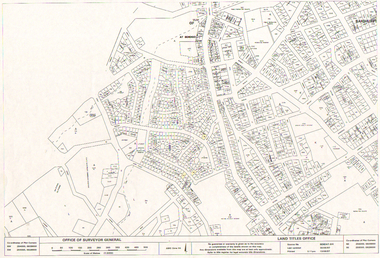
Map - LONG GULLY HISTORY GROUP COLLECTION: LONG GULLY AREA
... ... Office of Surveyor General...History House 11 Mackenzie Street Bendigo goldfields BENDIGO History long gully history group The Long Gully History Group - Long Gully Area Land Titles Office Office of Surveyor General City of Bendigo Shire of Marong State Electricity Commission Copy of a map showing streets and allotments in the Long Gully area, last updated 30/05/97, printed 19/06/97. ...Copy of a map showing streets and allotments in the Long Gully area, last updated 30/05/97, printed 19/06/97. Made by the Land Titles Office. Some street names, reserves and allotment numbers are printed on the map.bendigo, history, long gully history group, the long gully history group - long gully area, land titles office, office of surveyor general, city of bendigo, shire of marong, state electricity commission -
Hume City Civic Collection
Map, Sunbury Township 1857
... This is a reprint of a 1857 map of the township of Sunbury in the County of Bourke produced by the Public Records Office by courtesy of the Surveyor General in 1978....Hume City Civic Collection 44 Macedon Street Sunbury melbourne This is a reprint of a 1857 map of the township of Sunbury in the County of Bourke produced by the Public Records Office by courtesy of the Surveyor General in 1978. Sunbury Shire of Bulla Sunbury township 1850s This is a reprint of a 1857 map of the township of Sunbury. ...This is a reprint of a 1857 map of the township of Sunbury in the County of Bourke produced by the Public Records Office by courtesy of the Surveyor General in 1978.This is a reprint of a 1857 map of the township of Sunbury.sunbury, shire of bulla, sunbury township, 1850s -
Federation University Historical Collection
Document, Zelda Martin, Central Victorian Goldmining towns - Boom Towns or Ghost Towns?, c1996
... General / Finance / Gold / Gazette / Commission and Warrant / Statistic. *Gold Fields Act. In accordance with the Act the gold fields are divided into six districts - Ballaarat, Castlemaine , Sandhurst, Avoca, Ararat, and Beechworth.. Official staff in each gold district consists of a Resident Warden, Wardens, Wardens' Clerks, Bailiffs, Chinese Protectors, Chinese Interpreters, and Mining Surveyors. *Gold Receiver *Gaols *Police magistrates and Clerks of Petty Sessions, etc. *Field Branch *Immigration and Emigration Overland - Chinese - 1859 *Population on the Goldfields *The Geological Survey - The Government Geologist is assisited by staff from four branches - the office...General / Finance / Gold / Gazette / Commission and Warrant / Statistic. *Gold Fields Act. In accordance with the Act the gold fields are divided into six districts - Ballaarat, Castlemaine , Sandhurst, Avoca, Ararat, and Beechworth.. Official staff in each gold district consists of a Resident Warden, Wardens, Wardens' Clerks, Bailiffs, Chinese Protectors, Chinese Interpreters, and Mining Surveyors. *Gold Receiver *Gaols *Police magistrates and Clerks of Petty Sessions, etc. *Field Branch *Immigration and Emigration Overland - Chinese - 1859 *Population on the Goldfields *The Geological Survey - The Government Geologist is assisited by staff from four branches - the office ...Zelda Martin was a PhD candidate at the University of Melbourne.[.1] 4th item in light blue display book titled Research Approach/Overview of Chapters/Confirmation of Canditure/Chapters1,2,3&4 of proposed thesis. *Twenty-seven page article on Victorian goldfields towns titled: Central Victorian Goldmining Towns - Boom Towns or Ghost Towns. The article was written during the author's PhD study. It outlines the context methodology, and resources and the chapters of the proposed thesis: (1) Central Victorian Goldmining Towns - The Context (2) Contemporary Views of the Factors Necessary for Town Growth (3) Outward Manifestations of Town Growth (4) The Trappings of Government (5-9) The Main Towns and Their Hinterland. [.2] 5th item in Light Blue display book as above item. *Chapter 1 of proposed thesis titled 'Pick, Shovel and Tin Dish Mining.' Covers in Section A: Central Victoria - Pre 1851: Aborigines in Central Victoria, Squatters, and Government. Section B: The years 1851-1854: The Early Gold Rushes, Government Reaction, Township Surveys, Legislation, Town Development, Local Government and Early Settlement. [.3] 6th item in Light Blue display book as above item. *2A of proposed thesis titled 'Contemporary Views of the Factors Necessary for Town Growth'. Similar information to Chapter 1 plus extra re towns and maps. Sections: Introduction, Context of Place - Geographical Towns Listed, The Context of Time - Pre1851 Aborigines, Governance of Port Phillip, The Squatters, The Villages of Central Victorian Highlands, Conclusion, Condensed Version of Chapter2B. [.4] 7th item in Light Blue display book as above item. *Chapter2B of proposed thesis. Sections: Area of Research, Schools, Banks, Newspapers, Progress Association, Town Development - Sandhurst (Bendigo), Ballarat, Castlemaine,, Maryborough, Ararat and Stawell. [.5] 8th item in Light Blue display book as above item. *Chapter 3 of proposed thesis titled 'Outward Manifestations of Town Growth'. Sections: Introduction, Contemporary Writing, Educationalists, The Bankers, The Townsfolk, Current Theory, General Theories of Urban Development, and Conclusion. [.6] 9th item in Light Blue display book as above item. *Chapter 4 of proposed thesis titled 'Trappings of Government' Sections: Introduction, Early Government Attitudes to Mining and Town Development, Law and Order, Township Surveys, Legislation, Local Government, Transport and Communication, The People and Lobbyists. [.7] 10th item in Light Blue display book as above item. *'The Rise and Fall of Central Victorian Goldmining Towns'. Includes a map showing main Goldfields, a table showing towns and villages at two points in time - 1857 and 1871; a Bibliography of Primary and Secondary Sources. [.8] Resource No1. Black display book titled Local Towns 1 : Alma: *Brief history *Directory *Maps Amphitheatre / Mountain Hut: *Brief History Post Office Directory Ararat: *Brief History *Post Office Directory 1869 - Alphabetical Listing by Occupation *Ararat - Prominent Citizens of 1858 *Langi-Morgala Museum Avoca: *Brief History *Excerpts from 'Avoca The Early Years', Margery and Betty Beavis; pg1 - Beginnings; pg11 - The Midas Touch; pg25 - Local Gold Escorts; pg27 - A Town is Born; pg51- The Administration of Justice; pg53 - The Ways of the Law; pg61 - News of the Day; pg65 - A Time to Play; pg72 - Land Ownership *Post Office Directory (Bailliere's) 1869 *Tourism Map and Information of area *Historic Avoca - A 5.5km Tour *Avoca & the Pyrenees Region - information pamphlet Ballarat: *Early History of Ballarat - Ballarat Historical Society, Publication No.1: origin of the name; Ballaarat - the Beginning; Fabulous Yields from the Ballaarat Goldfield; *Streetscape Lydiard Street. *Hand drawn map showing Leigh River, Old Portland Bay Road, plaque on road to Colac; etc. *Newspaper article re 'The Theatre Royal' ( which stood in the vicinity of the current Owen Williams store) - 'The News'15/04/1998 *Article - 'Ballarat's Mechanics' Institute Lives On' Ballarat Courier, 14/09/1985 *Article - Standing the Test of Time' The News 17/11/1993 re The Mechanics Institute & picture of the Reading Room *'Ballarat a Study of a City, Phyllis Reichl, pub. Nelson, 1968; no.3 place, time and people field studies series *Investigator Vol.33 No.2, 1998 Geelong Historical Society. Article on pg75 describes Ballarat in 1861 *Folded poster - 'Ballarat 100' a history of telegraph communication, pub. Telecom. Beaufort (Fiery Creek): *Brief history *Post Office Directory [.9] Resource No.2 Black Folder Titled Towns cont.No2 Bendigo (Sandhurst): *'Family & Local History at the Bendigo Library - 1851-2001 150 years of gold'. *Bendigo Government Camp in 1853 illustration; key to sketch and names of Government officers stationed there *Excerpts from 'Bendigo and Vicinity' Adolph Haman *The Bendigo Goldfield Registry - pgs 1-7 Introduction *Excerpt: 'Breaking the Grip' *Excerpt: The Most Go-Ahead Place *Excerpts from 'History of Bendigo' - anti license agitation; laying out of town; proposed railway; gold calls and dividends; the Sandhurst Municipality; journalism *Bibliography Blackwood: *Excerpts from 'Aspects of Early Blackwood - The Goldfield, the Landmarks, the Pioneers' Alan J Buckingham and Margaret F Hitchcock, JG Publishing,1980 Buninyong: *A Brief History *Investigator Vol1 No.2 Feb 1966 Geelong Historical Society. Pg3 - Article re gold escort route - Mt Alexander to Adelaide - (see a simple monument on the Western Highway a few miles out of Horsham. Pg 15 - Ballarat Excursion - re the finding of gold. *Three articles published by Buninyong and District Historical Society Inc: (Magpie Exploration; Finding Gold In The Green Hills; Magpie Exploration; Burnt Bridge to Cargarie to Mt Mercer) *Copies of newspaper articles/items *Buninyong Street Directory Carisbrook: *In the Beginning There Was Carisbrook *The History of the Carisbrook Racecourse Carngham / Snake Valley: *Brief History *Directory Castlemaine: *Directory 1865-1866 - Alphabetical and Street *Poster - Castlemaine A Contemporary Guide "The Great Centre" 1866 - A Contemporary Guide to the Fascinating Past *Pamphlet - Castlemaine District Community Hospital *Map - Castlemaine, Maldon & Surrounding Districts *Map and Information - The Dry Diggings Track - a 55kl walk among historic goldfields relics ( Castlemaine Fryerstown Vaughan Mt Franklin Hepburn Daylesford) *Postcard - Former Court House *Directory 1867 - Alphabetical, Trade [.10] Resource No.3 Grey folder Titled Towns 3 Creswick to Maryborough Creswick: *Brief History *Booklet - "Creswick Cemetery Walk" *Booklet - The Buried Rivers of Gold Heritage Trail Creswick *Creswick Historical Museum Information Sheet *Chronological History of Creswick *Alphabetical Directory of the Borough of Creswick *Creswick's Creek Directory 1856 *Historic Creswick Walking Tour *A Brief Account of the Schools of Creswick - Past and Present *100 Years of Railway Travel in Creswick *The Berry Deep Leads *The Spence Home at Jackass Gully in the Creswick State Forest ( William Guthrie Spence - Pioneer) *The New Australian Mine and the 1882 Disaster *Creswick District News, Issue 7, July August 1999 *The Creswick Miners Walk - Information and Map *Maps Chewton: *Brief History *Directory Clunes: *Brief History *Clunes Street Directory Daylesford: *Brief History *Notable Bushfires in Daylesford District Over More Than a Century - "Black Thursday" 1851; 1862; 1899; the Disastrous Hepburn Fire of 1906; 1939; 1944; 1969. *Post Office Directory -Daylesford and Hepburn Dunolly / Inkerman: *Brief History *Directory *Pamphlet - Goldfields Historical Museum *Pamphlet - Historic Dunolly - Victoria's Best Kept Secret *Map of Gold Workings at Dunolly Area - showing where the main gold rushes occurred *Brief History - Inglewood *Directory - Inglewood - Name Occupation, Dwelling Kingower: *Brief History *Directory - Name / Ocupation / Dwelling Linton / Happy Valley / Piggoreet: *Brief History *Directory - Lintons McIvor: *"A History of the Shire and the Township of Heathcote" by J.O. Randell Majorca: *Brief History *Official Post Office Directory 1869 - Name / Occupation/ Address Maldon (Tarrangower): *Brief History Part 1 *Brief History Part 2 *Post Office Directory *List - Alphabetical Order by Names plus Business and Trade (Tarrangower Times Oct/1858) *List - Alphabetical Order by Trade plus Name and Business *Directory - Name / Occupation / Dwelling Maryborough: *Worsley Cottage - built by Arthur Worsley, a contractor in stonework in 1894 [.11] Resource No. 4 Blue Display Book titled Towns 4 Moliagul to Stawell Moliagul: *Brief History *Moligul Legislative Assembly (Voting?) List - Names and Occupations *Moliagul Victorian Post Office Directory 1868 - Name / Ocupation / Address / Comments *"The Welcome Stranger" gold nugget *The Sunday School *The Welcome Stranger Discovery Walk - information and map Moonambel (Mountain Creek) Redbank *Brief History *List of names extracted from advertisments of the Pioneer and Mountain Creek Advertiser 16/02/1861. *Bailliere's Directory 1869 - Alphabetical List of Name / Occupation / Place St Arnaud: *Brief History Sebastapol: *Brief History *Directory 1869 - Alphabetical by Name; plus occupation and address. Browns and Scarsdale: *Brief History *Browns Street Directory - Name and Occupation Smythesdale: *Brief Description *Smythesdale Street Directory -Name and Occupation Stawell (Pleasant Creek) *Brief History *Victorian Official Post Office Directory - Name /Occupation / Dwelling *Chronology - 1841-1920 *Production of gold statistics - 1879 - 1900 *Big Hill *Extracts from "The Golden Years of Stawell". Chapt 1 - Stawell's Coming Out. Capt. 2 - The Gold Rush. Caapt.3 - Cradle of Democracy. Chapt.4 - The Reefs Becomes Stawell. Chapt. 5 - Rushing In. Chapt.6 - The Pioneers. Chapt 7 - The Decade of Optimism. [.12] Resource No. 5: Blue Display Book titled 'Towns Steiglitz to the The Golden Triangle. Steiglitz: Brief History Victorian Post Office Directory 1869 *Map of Steiglitz *List of maps relevant to Steiglitz history *Information 6 tables of data from "Reports of Mining Surveyors Talbot (Back Creek) Brief History Taradale: Post office Directory 1869 - Name/Occupation/Street. Also list in alphabetical order by Occupation Taradale *Chronological Reference to Taradale Mines *Water - The Coliban System of Waterworks *Joseph Brady *The Syphon Tarnagulla (Sandy Creek) *Brief History *Tarnagulla Businessmen Cameos to give depth to advertisments in 'The Tarnagulla Courier' various issues 1864-1871 *Directory - Name/Occupation /Address *List - Name/Business/Trade Wedderburn (Koorong) *Brief History *List - Name/Occupation The Golden Triangle: *The Early Rushes - Wedderburn / Moliagul / Sandy Creek - Tarnagulla / Jones Creek - Waanyarra / Kingower / Dunolly - Goldsborough / Inglweood *Census of 1857 - Population / Occupations *1858-1871 - A Time of Consolidation- Wedderburn / Moliagul / Sandy Creek- Tarnagulla / Arnold *Census 1871 - Population *Information gleaned from the census data - Demographics / Population / Occupations / marital / Birthplace / Religion / Literacy/ Occupation and Housing Cameos *Graphs - Birthplace of settlers /Male-Female Ratio / Married males / Children under 15 as Percentage of Population / Religion *Census 1857 - Statistical data *Maps *Bibliography [.13] Resource No. 6 - Black Display Book Information and Research in Central Victoria including: *Banking - Research from ANZ Bank Archives *Institutions - also includes articles listed from the Ballarat Times Newspaper *Australian mining History Association - A.M.H.A. Bibliography *Australia's Mining History * Bibliography - Land Surveys Victoria - *1853 Administration (Statistics and Other) includes: schools / ministers of religion / police / military / local administration / licences for sale of spirits / distances between various Victorian gold fields. * Victoria Government Gazette (Copy) - N0. 116, 12/12/1854 includes: Gold Felds Commission of Enquiry & No. 85, 15/09/1854 - Addresses presented to the Lieutenant Governor (Sir Charles Hotham) during his tour through the Gold Fields of Victoria,1854. Addresses on behalf of : the people of Bendigo; Members of the Church of England, Bendigo; Members of the Wesleyan Church on the Bendigo Gold Fields; Bendigo Gold District General Hospital; the Bendigo Prospecting Association; Committee of the Bendigo Local Exhibition; Bendigo District Medical Association; Coloured Americans Resident at Bendigo; German Inhabitants of Bendigo; Landowners, Inhabitants, and Miners of Castlemaine; Inhabitants of Forest Creek; Inhabitants of Heathcote and Gold Miners of McIvor; Residents and landholders of the District of Bacchus Marsh; Inhabitants of Kilmore and Vicinity. *Gold Fields Correspondence 1853: letter from Lieutenant Colonel Valiant, (Officer commanding the Troops in Victoria) to the Lieutenant Governor re threatened disturbance at Sandhurst (Bendigo) regarding the Gold License Fee. * Extracts from a book "Victoria" re Gold Fields Commission of Enquiry involving mainly Ballarat and Castlemaine and a chapter titled 'A Tour to the Victorian Gold-Fields' *Lists of central Victorian newspapers - listed by date published 1851to 1874; by first date available to State Library. *A list of cities and towns showing County, population in 1861 &1871, and municipal status. [.14] Resource no.7. Black display book. *Reference: Papers presented to Parliament Victoria - 1859-1860 4 volumes - relevant sections copied. Contains information on Branches of Government. General / Finance / Gold / Gazette / Commission and Warrant / Statistic. *Gold Fields Act. In accordance with the Act the gold fields are divided into six districts - Ballaarat, Castlemaine , Sandhurst, Avoca, Ararat, and Beechworth.. Official staff in each gold district consists of a Resident Warden, Wardens, Wardens' Clerks, Bailiffs, Chinese Protectors, Chinese Interpreters, and Mining Surveyors. *Gold Receiver *Gaols *Police magistrates and Clerks of Petty Sessions, etc. *Field Branch *Immigration and Emigration Overland - Chinese - 1859 *Population on the Goldfields *The Geological Survey - The Government Geologist is assisited by staff from four branches - the office Branch; the Publishing Branch; the Field Branch and the Museum Branch. *Commission to Enquire Into Sludge dated 10/02/1859 (Some sections copied) - Report to the Honorable Chief Commissioner of Public Works, Melbourne re the mode of carrying the sludge from the puddling mills in Sandhurst without interfering with the drainage of the town and the roads in the neighbourhood. [.15] Resource No.8: Camel display book titled Resource No. 8. Aborigines *Lists of book titles - +"Readings in Victorian prehistory" +"The Aborigines of Port Phillip" +Aboriginal languages and clans" +"A History of the Port Phillip District" +"Langi Ghiran 1: Aboriginal Rock...." +"Koorie History: sources for aboriginal studies in the State Library of Victoria", ed. Tom Griffiths, Melb. Friends of the State Library, 1989 +"The Public Lands of Australia Felix"; settlement and land appraisal in Victoria1834-91 with special reference to the Western Plains", J.M.Powell, Melb. Oxford University Press 1970 +*Bibliography of the Victorian Aborigines' from the earliest manuscripts to 31st December 1970, Massoa, Aldo, Melb. Hawthorn Press, 1971 +"Aborigines in Colonial Victoria, 1836-1886", M.F. Christie, Sydney University Press, 1979 +"Urban and Industrial Australia: readings in Human Geography" ed J.M. Powell, Melb. Sorrett Pub. 1974 *Extracts: -Processes of Pioneer Settlement - The Squatting Occupation of Victoria, 1834-60. J.M. Powell -Areal Variations in the Class Structure of the Central-Place Hierarchy. P. Scott - Volume1 and Volume 2: Notes Relating to the Habits of the Natives of Other Parts of Australia and Tasmania. Compiled from various sources for the Government of Victoria by R Brough Smyth. John Curry, O'Neil, Melb. 1st pub. Melb. 1876. p31-45 - Numbers and Distribution of the Aborigines in Victoria -Victorian Aborigines 1835-1901 - A Resource Guide to the Holdings of the Public Record Office, Victoria; published by the Government Information Centre 1984. *History of the Aboriginal Artefacts Displayed in the Daylesford Museum. F. G. Powell (4 page pamphlet) *Letter to Zelda Martin from Peter Lovett, Cultural Officer, Ballarat & District Aboriginal Co- Operative, 05/02/1997 *Map: Ian Clarke Victorian Tribunal Boundary Map - Clans of Central Victoria. *Victorian Rock Art and Mythology - Article about Mount Langhi Ghiran and myths of the Tjapwarong people. *Two Aboriginal myths relating to the Grampians - 'The Monster Emu' / 'The Aquisition of Fire', by the Aborigines in the Grampians Areas *Article titled (chapter 8) Ballarat - information re camping sites in the region. Lake Wendouree / Lake Burrumbeet (includes a myth) / Mt Bunninyong / Lal Lal / Pitfield / Mount Elephant / Mount Egerton / Meredith / Lake Goldsmith / Lake Learmonth / Ercildoune *Notes on the Aborigines of the Wider Ballarat Region plus European names=Aboriginal names. John Morris 26/07/1995 *Role of Aborigines in Town Development in Central Victoria. Mentions Native Police Force est. in Port Phillip 1842 and Central Board for Aborigines est. 1860 *The Grave of King Billy. (Frank Wilson) Pamphlet. *Camping Places in Central and Northern Victoria. Article re Lake Burrumbeet site. *Programme for the Unveiling of Memorial Cairn for Edward Stone Parker 1802-1865. Note portrait not accurate. Accurate portrait is available in the book "A Successful Failure A Trilogy The Aborigines and Early Settlers", Edgar Morrison, Graffiti Publications, 2002. * Large envelope addressed to Mr G Netherway containing newspaper cuttings regarding the life of Edward Stone Parker, the unveiling of the Memorial Cairn as mentioned above, articles titled 'Episodes from Our Early Days' (Edgar Morrison, Yandoit)- The Black's School, A School At Last and The Final years. Also a typed page titled 'Historical Background to E.S.Parker's Career. Includes an interesting tale titled 'When the cat lay doggo' re laying power leads for the unveiling ceremony at the memorial site. [.16] green display folder titled 'Research Aids' *List of references to Commissioners' & W'ardens' Reports (formerly held at La Trobe Library Archives, now at Public Records Office [PRO]). Indicates town referred to / date of report / name of camp if different to town. * Archive information re Anglican Records *Movement around the Goldfields - Miners and Storekeepers - usefulness of newspapers in providing information - areas covered - Castlemaine, Maldon, Ararat, Stawell, Tarnagulla, Dunolly. *Port Phillip /Victoria Directories 1839/1867 - Chronological list of Directories included in this series. *"Notes on the History of Local Government in Victoria" A.W. Greig Melb. University Press 1925 - Photo-copied extract p5-p40. (Source - Deakin University Library) - Introduction by W.Harrison Moore. Section 1 - Development in New South Wales Before Separation. Section 2 - Development in Victoria After Its Separation from New South Wales. Hand written notations: 'roads, markets, and local government 1855 on' ;'opportunity of squatters in parliament' and 'opportunities of matters in parliament p33' * Notes on the Establishment of Surveyor General's Department 1851and Commissioner of Crown Lands and Survey. * Newspaper articles from The Argus, 1849, re the discovery of gold in the Pyrenees region. * Excerpt - a report on schools - A.B.Orlebar, Inspector; re the need for permanent school buildings rather than tents. *Excerpt from - 'Approaches to Urban History', Sean Glynn: The Case for Caution * Except from - 'The Urban Sprinkle', Weston Bate: Country Towns and Australian Regional History *Reference- 'The History of Land Tenure in the Colony of Victoria', John Quick. References the Haines Land Bill, land tenure and Land Leagues. [.17] Light blue envelope folder titled 'Birtchnell's Ballarat, etc. Directory 1862 *Contains various directories for Smythesdale, Buninyong, Clunes, Brown's and Creswick. [.18] Red envelope folder no.2 titled Victorian Gazetteer *Selected pages from 1869 Victorian Gazetteer on A4 paper (with a handwritten note questioning if some pages are from 1868 Victorian Gazetteer as appears to be different sizes - A3 pages.) Information includes locations and descriptions of towns, hotels, banks, communications and populations. (Does not include names, residences and occupations) [.19] Red Envelope folder titled Bailliere's Official Post Office Directory 1868 (or1869 or a mixture of both?) *Preface *Contains a selection of pages of towns highlighted in yellow in the the index *Work on this directory was commenced in 1867. *Information includes: Municipalities - mayors and councilors; lists of towns naming male inhabitants and their occupations. [.20]Yellow manila folder titled Post Grad Seminar Presentation 1996 *Gives some background to Zelda Martin's proposed thesis and why she chose the topic Gold Mining Towns Boom or Bust [.21] A3 display book - No. 1A * A list of 'Relevant Newspapers collected: The Tarrangower Times and Maldon Advertiser (first published 1858) Includes dates 1858-1867. The Mount Alexander Mail. Includes dates 1854-1866 The Tarnagulla Courier. Includes dates from1864-1871 Dunolly and Burnt Creek Express. Includes dates from 1862-1871 * Selection of newspaper pages from The Mount Alexander Mail 1854 to 1856, mostly showing advertisements for businesses and services provided to that community. [.22] A3 display book - No. 1B * Selection of newspaper pages from The Mount Alexander Mail 1857 to 1866, mostly showing advertisements for businesses and services provided to that community. [.23] A3 display book -No. 2 * Selection of newspaper pages from The Tarnagulla Courier 1864 to 1871, mostly showing advertisements for businesses and services provided to that community. [.24] A3 display book - No. 3 *Selection of newspaper pages from The Tarrangower Times (and Maldon and Newstead) Advertiser 1858 to1867, mostly showing advertisements for businesses and services provided to that community. [.25] A3 display book - No.4 * Selection of newspaper pages from The Dunolly and Burnt Creek Express; and The Dunolly and Betbetshire Express 1862 to 1871, mostly showing advertisements for businesses and services provided for that community. [.26] A3 display book - No.5 Includes: * Bryce Ross's Diggings Directory. Includes instructions for using this directory. This directory was used by "all persons having connexion or desiring to communicate with 'working parties, private friends, or Stores at the Diggings." As a directory for each area wwas completed it was published in each month's issue of Bonwick's "Digger's Magazine." Years c1852/1853. This Directory commences first at the head of Forest Creek. Includes a directory for Bendigo and Ballarat. Of interest at the end of the Bendigo and Ballarat directory is a list of the number of storekeepers, butchers, doctors, smiths, eating houses, lemonade sellers and chapels. * The Castlemaine Directory and Book of General Information Comprehending Glass's Model Calendar for the Two Years 1862 and1863. "zelda martin, victorian goldfield towns, bendigo, castlemaine, ballarat, maldon, stawell, ararat, maryborough, creswick, avoca, heathcote, banks, bank of australasia, union bank of australia, government camp, sandhurst, water supply, tarnagulla, talbot, back creek, mountain creek, police court, carisbrook, dunolly, thompson's foundry, charles clacy, anthony trollope, robert cecil, mount alexander, urbanisation, national schools, education, govenrment, industry, railway, transport, settlement, land settlement in central victoria, steiglitz, joseph brady, the new australian mine, berry deep leads, william guthrie spence, creswick state forest, arthur worsley, worsley cottage, the welcome stranger, moliagul, moonambel, redbank, st arnaud, sebastapol, brown's, scarsdale, clunes, chewton, daylesford, bushfires, inkerman, inglewood, kingower, lintons, happy valley, piggoreet, mcivor, majorca, tarrangower, taradale, the coliban system, the syphon, sandy creek, wedderburn, koorong, arnold, jones creek, waanyarra, the golden triangle, census 1857, blackwood, buninyong, durham lead, magpie, carngham, snake valley, alma, amherst, daisy hill, amphitheatre, mountain hut, beaufort, fiery creek, counties, population, gold fields commission of enquiry1854, william westgarth, gold license fee, lieutenant colonel valiant, administration of the victorian gold fields, commission to enquire into sludge 1859, e.s. parker, edward stone parker, edgar morrison, mount franklin protectorate, dja dja wurrung, memorial cairn, franklinford, mt franklin memorial cairn, jajowurrong, dja dja wurung, tjaowarong, wothowurong, assistant protectors, daylesford museum, buluk, rock art - grampians, aboriginal mythology - grampians, aborigines, first nations people, mount franklin, aboriginal artifacts, lake burrumbeet, native police force, central board of aborigines, yandoit, commissioners' reports, wardens' reports, port phillip/victoria directories 1839-1867, local government - victoria 1853/1854, surveyor general's department - 1850's, victorian schools 1850's, a.b.orlebar, haines land bill, william charles haines, wilson gray, land tenure, land leagues, victorian gazetteer, the tarrangower times and maldon advertiser - 1858-1867, the mount alexander mail 1854-1866, the tarnagulla courier 1864, dunolly and burnt creek express 1862-1871, bryce rose's diggings directory, the castlemaine directory 1862-1863 -
 Bendigo Historical Society Inc.
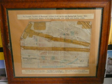
Document - PLAN OF TOWNSHIP OF SANDHURST 1854, July 25. 1854
... Lithographed at Surveyor Generals Office. Melbourne. July 25. 1854. ...History House 11 Mackenzie Street Bendigo goldfields PLACE Bendigo original 1854 bendigo map Lithographed at Surveyor Generals Office. Melbourne. July 25. 1854. By R. ...Coloured- The planned township of Sandhurst is placed over the early Bendigo creek township of 1854. The two main streets of the early township were Camp and Auction streets. The street shown as Dowling street later became Queen & Hopetoun streets. The building near the bridge at View Point is Pykes Building. The Post Office was located here in 1854 - 58. Bernal street is now Chapel street. The creeks were straightened to their present courses. Streets on map are. Pall Mall - Bridge - McCrae - Hargraves - Lyttleton - Myers - Mollison - McLaren - Mitchell - Williamson - Mundy - Bernal - Baxter - Larritt - Bramble - McIvor - Bull. Also shown on map: Bendigo Creek - Government Reserve - Present Cemetery - Proposed diversion of creek. FH 562 Deframed 2022Lithographed at Surveyor Generals Office. Melbourne. July 25. 1854. By R. Meikle.place, bendigo, original 1854 bendigo map -
 Bendigo Historical Society Inc.
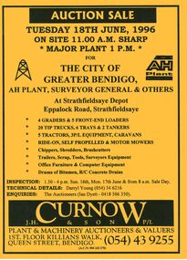
Document - IAN DYETT COLLECTION: AUCTION CATALOGUE - THE CITY OF GREATER BENDIGO
... Surveyor General & Others at Strathfieldsaye Depot, Strathfieldsaye. For sale were Earth moving equipment, tractors, 3 P/L equipment, caravans, various mowers, chippers,shredders, brush cutters, trailers, scrap, tools, Surveyors equipment, office furniture & computer equipment, drums of bitumen and R/C concrete drains. ...History House 11 Mackenzie Street Bendigo goldfields BUSINESS Auctioneers j h curnow & son pty ltd Ian Dyett Collection - Auction Catalogue - The City of Greater Bendigo AH Plant Surveyor General & Others Darryl Young Ian Dyett J H Curnow & Son P/L Coliban Water Noel Dyett Fred Dyett Bright yellow auction catalogue with black printing for a sale on 18th June, 1996 for the City of Greater Bendigo, AH Plant, Surveyor General & Others at Strathfieldsaye Depot, Strathfieldsaye. For sale were Earth moving equipment, tractors, 3 P/L equipment, caravans, various mowers, chippers,shredders, brush cutters, trailers, scrap, tools, Surveyors equipment, office ...Bright yellow auction catalogue with black printing for a sale on 18th June, 1996 for the City of Greater Bendigo, AH Plant, Surveyor General & Others at Strathfieldsaye Depot, Strathfieldsaye. For sale were Earth moving equipment, tractors, 3 P/L equipment, caravans, various mowers, chippers,shredders, brush cutters, trailers, scrap, tools, Surveyors equipment, office furniture & computer equipment, drums of bitumen and R/C concrete drains. J. H. Curnow & Son P/L were the auctioneers. Map of how to get to auction site inside front cover. Loose pink Supplementary List, account Coliban Water listing backhoe/F.E. loaders, tractor, tipper crane and 4WD wagon listed.business, auctioneers, j h curnow & son pty ltd, ian dyett collection - auction catalogue - the city of greater bendigo, ah plant, surveyor general & others, darryl young, ian dyett, j h curnow & son p/l, coliban water, noel dyett, fred dyett -
Port Melbourne Historical & Preservation Society
Map - Survey Map, Captain R Pasley R E, 24 Sep 1855
... Port Melbourne Historical & Preservation Society Port Melbourne Town Hall 333 Bay Street Port Melbourne melbourne melbourne Survey map to accompany Colonial Engineers Report, September 1855 Map Survey Map Captain R Pasley R E Surveyor General's Office J Jones Lith ...Survey map to accompany Colonial Engineers Report, September 1855melbourne -
Port Melbourne Historical & Preservation Society
Plan - Township of Sandridge, 1855
... Port Melbourne Historical & Preservation Society Port Melbourne Town Hall 333 Bay Street Port Melbourne melbourne local government - municipal district of sandridge town planning j jones COPYRIGHT PUBLIC RECORDS OFFICE Plan of the Township of Sandrdge 1855 - copy from Public Record Office 1978 Plan Township of Sandridge Surveyor General's Office J Jones ...COPYRIGHT PUBLIC RECORDS OFFICE Plan of the Township of Sandrdge 1855 - copy from Public Record Office 1978local government - municipal district of sandridge, town planning, j jones -
 Bendigo Historical Society Inc.
Document - MARKS COLLECTION: STRATHFIELDSAYE PLAN 1854
... Scale (shown) Lithographed at the Surveyor Generals Office, Melbourne July 10th. By I. ...Scale (shown) Lithographed at the Surveyor Generals Office, Melbourne July 10th. By I. ...Plan drawn on light paper. Written on LH side of plan 'Plan of Part of the Parish of Strathfieldsaye 1854. Scale (shown) Lithographed at the Surveyor Generals Office, Melbourne July 10th. By I. Jones'. Plan shows Emu Creek and Village Reserve at top of plan, Shepherd's Creek on RH side, Parish Boundary Line on RH and bottom of plan.map, bendigo, shire of strathfieldsaye 1854 -
 Bendigo Historical Society Inc.
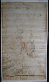
Map - PLAN GENERAL SURVEY MALMSBURY PORCUPINE INN, FOREST CREEK TO GOLDEN POINT. ALEXANDRA RANGE 1853
... Surveyor General. ' Stamped by Department of Mines Victoria with record#123 in Top right Hand corner. Also contains a catalogue number 2053/M/2. Part of the Contents of a DVD entitled 'Mapping Great Change' - Archival Maps, produced to support an exhibition in the Post Office Gallery Bendigo. ...Surveyor General. ' Stamped by Department of Mines Victoria with record#123 in Top right Hand corner. Also contains a catalogue number 2053/M/2. Part of the Contents of a DVD entitled 'Mapping Great Change' - Archival Maps, produced to support an exhibition in the Post Office Gallery Bendigo. ...Colour Copy of Plan of the General Survey from the Town of Malmsbury to the Porcupine Inn, from the sources of Forest Creek to Golden Point, shewing (sic) the Alexandrian Range also Sawpit Gully Bendigo and Bullock Creeks. Handwritten note under the title a follows '' Forwarded to the Colonial Secretary with my letter No A 53/105 dated 30th March 1853 for transmission to the Geological Surveyor. R Hoddle Surveyor General. ' Stamped by Department of Mines Victoria with record#123 in Top right Hand corner. Also contains a catalogue number 2053/M/2. Part of the Contents of a DVD entitled 'Mapping Great Change' - Archival Maps, produced to support an exhibition in the Post Office Gallery Bendigo. A description of the Map, its history and implications for both historical and future discussions is contained in an Essay 'Mapping Great Changes' : The landscape of central Victoria by Gerry Gill.R. Hoddlemap, bendigo, country lands -
 Bendigo Historical Society Inc.
Document - CONNELLY, TATCHELL, DUNLOP COLLECTION: ACCOUNTS ESTATE OF ESTHER ISABELL CANNING, 1893 -1894
... Office of London, Victorian Branch, 60 Market St, Melbourne. Insurance from fire for property - Hotel, high St. 8 - 1894 - Ac from S. P. Co-Operative Co, Mitchell St, Bendigo, General Grocers, Tea and Provision Merchants. 9 - 1894 - Ac from Forbes T, Surveyor, View St, Bendigo. ...Office of London, Victorian Branch, 60 Market St, Melbourne. Insurance from fire for property - Hotel, high St. 8 - 1894 - Ac from S. P. Co-Operative Co, Mitchell St, Bendigo, General Grocers, Tea and Provision Merchants. 9 - 1894 - Ac from Forbes T, Surveyor, View St, Bendigo. ...Document. Accounts of Estate of Esther Isabelle Canning. 1 - 1894 - Account from Hinchcliffe Edwin, M. D., View Street Bendigo. 2 - 1894 - Account from Jones T R, Chemist & Druggist, Hargreaves Street, Sandhurst. 3 - 1894 - Ac. From William Bruce & Sons, B. B. Brewery, Bridge St. Bendigo, Brewers, Aerated Waters and Cordial Manufacturers, 2 April 1894. 4 - 1894 - Ac. From William Bruce & Sons, B. B. Brewery, Bridge St Bendigo, Brewers, Aerated Waters and Cordial Manufacturers. 1 March 1894. 5 - 1893 -Ac. From Burt, E Mrs, Nurse. 6 - 1894 - Receipt from Phoenix Fire Office of London, Victorian Branch, 60 Market St, Melbourne. Insurance from Fire for Property - Cottage, High St. 7 - 1893 - Receipt from Phoenix Fire Office of London, Victorian Branch, 60 Market St, Melbourne. Insurance from fire for property - Hotel, high St. 8 - 1894 - Ac from S. P. Co-Operative Co, Mitchell St, Bendigo, General Grocers, Tea and Provision Merchants. 9 - 1894 - Ac from Forbes T, Surveyor, View St, Bendigo. Subdivision of Allotment 5, Section 29A at Golden Square. 10 - 1893 - Ac from Mackay & Co, Bendigo Advertiser Office, Market Square, Bendigo. 11 - 1893 - Ac from Pritchard Geo, Aerated Water and Cordial Manufacturer, Arnold St Bendigo. 12 - 1893 - Receipt from McKenzie R C. 13 - 1894 - Ac from C H Hobson & Co, General Auctioneers, Bendigo Arcade Auction Rooms, Hargreaves St Bendigo.cottage, miners, connelly, tatchell & dunlop, hinchcliffe edwin, jones t r, william bruce & sons, b b brewery, burt e mrs, phoenix fire office of london, s p co-operative co, forbes t, mackay & co, bendigo advertiser office, pritchard geo, mckenzie r c, hobson c h -
 Orbost & District Historical Society
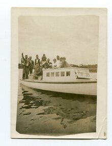
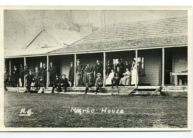
black and white photograph, 1936
... surveyor, E.L. Bruce set out 19 sections of the new township, with the first sales of subdivided land occurring the following May. At this time, Stirling's Marlo Hotel was the unofficial hub for the community. It was a general store, accommodation house and the unofficial post office...surveyor, E.L. Bruce set out 19 sections of the new township, with the first sales of subdivided land occurring the following May. At this time, Stirling's Marlo Hotel was the unofficial hub for the community. It was a general store, accommodation house and the unofficial post office ...This is a photograph of a fishing party at Marlo, East Gippsland, in 1936. On the back is a description written by Ruby Richardson. Ruby Richarson was born 1902 in Orbost. Her father was Albert Eli and mother Lettice Tomlinson. Ruby had sisters, Mary Agnes Jessie born 1897 and Grace Jane born 1905. Albert Eli Richardson, died in 1851 aged 90i Orbost, His father was given as George Samuel Richardson and mother Jane Farndon, (research - Lois Crisp) The first settler to occupy the Marlo township area was James Stirling around the year 1875. He built a bark hut on the bluff that had two rooms, bark walls, earthen floors and a shingle roof. By 1884, this structure had expanded to a 9 roomed accommodation house and in 1886 became the Marlo Hotel when a liquor license was granted The Governor-in-Council declared Marlo to be a township on 18 February 1889. During May 1889, the government surveyor, E.L. Bruce set out 19 sections of the new township, with the first sales of subdivided land occurring the following May. At this time, Stirling's Marlo Hotel was the unofficial hub for the community. It was a general store, accommodation house and the unofficial post office, with settlers taking turns in bringing the mail from Orbost or Cunningham. This continued until Aug 1942, and in 1969 was located in a house adjacent to the Marlo Hotel, before being transferred to the Marlo General Store in this year. The official Post Office List states the Marlo Post Office opened around 1902.[ In 1925, the "Marlo House" (a nine room accommodation guest house) was granted a liquor licence. The "Marlo House" became "The Marlo Hotel". The Marlo Hotel was popular with many Orbost and district settlers, who travelled to Marlo by horseback or buggy. Marlo has always been a popular destination for fishermen. A small black / white photograph of a group of men and women on a small boat.on back - "Fishing party..................Ruby Richardson"marlo-fishing recreation-fishing -
 Orbost & District Historical Society
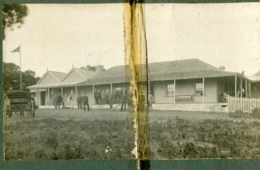
black and white photograph, C1900
... surveyor, E.L. Bruce set out 19 sections of the new township, with the first sales of subdivided land occurring the following May. At this time, Stirling's Marlo Hotel was the unofficial hub for the community. It was a general store, accommodation house and the unofficial post office...surveyor, E.L. Bruce set out 19 sections of the new township, with the first sales of subdivided land occurring the following May. At this time, Stirling's Marlo Hotel was the unofficial hub for the community. It was a general store, accommodation house and the unofficial post office ...The first settler to occupy the Marlo township area was James Stirling around the year 1875. He built a bark hut on the bluff that had two rooms, bark walls, earthen floors and a shingle roof. By 1884, this structure had expanded to a 9 roomed accommodation house and in 1886 became the Marlo Hotel when a liquor license was granted. The Governor-in-Council declared Marlo to be a township on 18 February 1889. During May 1889, the government surveyor, E.L. Bruce set out 19 sections of the new township, with the first sales of subdivided land occurring the following May. At this time, Stirling's Marlo Hotel was the unofficial hub for the community. It was a general store, accommodation house and the unofficial post office, with settlers taking turns in bringing the mail from Orbost or Cunningham. This continued until Aug 1942, and in 1969 was located in a house adjacent to the Marlo Hotel, before being transferred to the Marlo General Store in this year. The official Post Office List states the Marlo Post Office opened around 1902. in 1925, the "Marlo House" (a nine room accommodation guest house) was granted a liquor licence. The "Marlo House" became "The Marlo Hotel". The Marlo Hotel was popular with many Orbost and district settlers, who travelled to Marlo by horseback or buggy. The Marlo Hotel, perched on the hill overlooking the estuaries and the entrance is a significat building in Marlo. Established in 1886, it has been operating for over 120 yearsA black / white photograph of the Marlo Hotel. Patrons are standing on the verandah and lawns. A horse-drawn carriage is on the left. The photograph is on a green buff card with a rough edge on R H side.on back - " Old Marlo Hotel"marlo-house marlo-hotel stirling-james -
 Orbost & District Historical Society
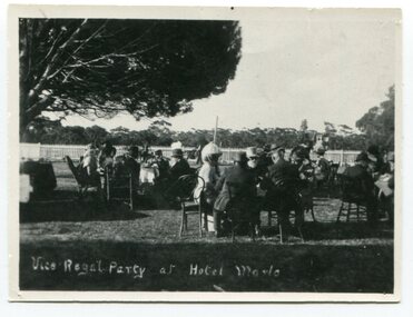
black and white photograph, late 19th century / early 20th century
... surveyor, E.L. Bruce set out 19 sections of the new township, with the first sales of subdivided land occurring the following May. At this time, Stirling's Marlo Hotel was the unofficial hub for the community. It was a general store, accommodation house and the unofficial post office...surveyor, E.L. Bruce set out 19 sections of the new township, with the first sales of subdivided land occurring the following May. At this time, Stirling's Marlo Hotel was the unofficial hub for the community. It was a general store, accommodation house and the unofficial post office ...The first settler to occupy the Marlo township area was James Stirling around the year 1875. He built a bark hut on the bluff that had two rooms, bark walls, earthen floors and a shingle roof. By 1884, this structure had expanded to a 9 roomed accommodation house and in 1886 became the Marlo Hotel when a liquor license was granted. The Governor-in-Council declared Marlo to be a township on 18 February 1889. During May 1889, the government surveyor, E.L. Bruce set out 19 sections of the new township, with the first sales of subdivided land occurring the following May. At this time, Stirling's Marlo Hotel was the unofficial hub for the community. It was a general store, accommodation house and the unofficial post office, with settlers taking turns in bringing the mail from Orbost or Cunningham. This continued until Aug 1942, and in 1969 was located in a house adjacent to the Marlo Hotel, before being transferred to the Marlo General Store in this year. The official Post Office List states the Marlo Post Office opened around 1902. in 1925, the "Marlo House" (a nine room accommodation guest house) was granted a liquor licence. The "Marlo House" became "The Marlo Hotel". The Marlo Hotel was popular with many Orbost and district settlers, who travelled to Marlo by horseback or buggy. In the early 20th century the hotel advertised itself as " Under Vice-Regal Patronage. Situated on High Cliff, fronting Ocean, Lakes and Snowy River. Those in search of Health, Rest and Sport should visit Marlo. Boating, Fishing, Shooting, Bathing, Golf. Comfort and Convenience at Marlo Hotel, near Orbost, East Gippsland. Nixon's Cars would meet the train at at Orbost. Fare---6s single, 12s return. Telephone No. 1, Marlo. S, P, STEWART, Proprietor." The Marlo Hotel, perched on the hill overlooking the estuaries and the entrance is a significant building in Marlo. Established in 1886, it has been operating for over 120 yearsAn original black / white photograph and a black / white copy of a party being held under trees on the lawn of the Marlo Hotel. It is a postcard with advertising of Marlo on the back.on back - "Where to spend your holiday - Marlo" on front - "Vice Regal Party at Hotel, Marlo"marlo-hotel -
 Orbost & District Historical Society
black and white photograph, C 1900
... surveyor, E.L. Bruce set out 19 sections of the new township, with the first sales of subdivided land occurring the following May. At this time, Stirling's Marlo Hotel was the unofficial hub for the community. It was a general store, accommodation house and the unofficial post office...surveyor, E.L. Bruce set out 19 sections of the new township, with the first sales of subdivided land occurring the following May. At this time, Stirling's Marlo Hotel was the unofficial hub for the community. It was a general store, accommodation house and the unofficial post office ...The first settler to occupy the Marlo township area was James Stirling around the year 1875. He built a bark hut on the bluff that had two rooms, bark walls, earthen floors and a shingle roof. By 1884, this structure had expanded to a 9 roomed accommodation house and in 1886 became the Marlo Hotel when a liquor license was granted. The Governor-in-Council declared Marlo to be a township on 18 February 1889] During May 1889, the government surveyor, E.L. Bruce set out 19 sections of the new township, with the first sales of subdivided land occurring the following May. At this time, Stirling's Marlo Hotel was the unofficial hub for the community. It was a general store, accommodation house and the unofficial post office, with settlers taking turns in bringing the mail from Orbost or Cunningham. This continued until Aug 1942, and in 1969 was located in a house adjacent to the Marlo Hotel, before being transferred to the Marlo General Store in this year. The official Post Office List states the Marlo Post Office opened around 1902. in 1925, the "Marlo House" (a nine room accommodation guest house) was granted a liquor licence. The "Marlo House" became "The Marlo Hotel". The Marlo Hotel was popular with many Orbost and district settlers, who travelled to Marlo by horseback Perched on the hill overlooking the estuaries and the entrance, the Marlo Hotel is a significant building in Marlo. It was established in 1886 and has been operating for over 120 years,A black / white photograph of Marlo House with staff and patrons standing and sitting on the verandah.on front - "H.S. Marlo House"marlo-house marlo-hotel -
 Federation University Historical Collection
Map, Ballaarat Gold Field, 1861, 1861
... "Compiled & Drawn from the Survey of Mining Surveyors Davidson, Fitzpatrick and Cowan & the Plans in the Surveyor General's Office by J. Brahe, 21st October 1861. ...In November 2004 the Central Highlands Regional Library presented a special edition of 200 copies of the 1861 map reproduced from a copy in their collection. ballarat map ballarat east lake wendouree survey mines robert davidson ballarat gold field 1861 yuille's swamp wendouree swamp little bendigo diggings gold leads old post office hill specimen hill bakery hill black hill dead horse creek brown hill pennyweight hill clayton hill soldiers hill golden point gum tree flat white flat poverty hill chinese village robert brough smyth Ballarat map 1861 Ballaarat Vineyard Dead Horse Gully Deadhorse Creek Invermay Black Hill Flat Gaelic Church Police Reserve Magpie Range Dalton's Flat Caadian Lead Rifle Butts Powder Magazine Bathing House Government Camp Gold Office Chinese Llanberrris Victoria Theatre Charlie Napier Hotel United States Hotel Grape's Hoel Clayton's Hill Cattleyard Hill Free Trade Hotel Esmond Lead Bakery Hill Black Hill Lead Juvenile Reformatory Ballarat Orphanage Lady Barkly Lead Triffet's Slaughter Yard Little Bendigo Melbourne Road T. Cowan Thomas Cowan "Compiled & Drawn from the Survey of Mining Surveyors Davidson, Fitzpatrick and Cowan & the Plans in the Surveyor General's ...A party of surveyors camped by Yuille's Swamp (later Lake Wendouree) and surveyed the countryside for a map to be produced by the Geological Survey of Victoria. In November 2004 the Central Highlands Regional Library presented a special edition of 200 copies of the 1861 map reproduced from a copy in their collection. Original 1861 map of Ballarat showing streets and leads. Blue dots indicate gold leads, and red lines indicate auriferous quartz reef and outcrops of quartz veins."Compiled & Drawn from the Survey of Mining Surveyors Davidson, Fitzpatrick and Cowan & the Plans in the Surveyor General's Office by J. Brahe, 21st October 1861. R. Brough Smyth, Secretary for Mines. The Honourable J.B. Humffray, M.L.A. Commr of Mines.”ballarat, map, ballarat east, lake wendouree, survey, mines, robert davidson, ballarat gold field 1861, yuille's swamp, wendouree swamp, little bendigo diggings, gold leads, old post office hill, specimen hill, bakery hill, black hill, dead horse creek, brown hill, pennyweight hill, clayton hill, soldiers hill, golden point, gum tree flat, white flat, poverty hill, chinese village, robert brough smyth, ballarat map 1861, ballaarat vineyard, dead horse gully, deadhorse creek, invermay, black hill flat, gaelic church, police reserve, magpie range, dalton's flat, caadian lead, rifle butts, powder magazine, bathing house, government camp, gold office, chinese, llanberrris, victoria theatre, charlie napier hotel, united states hotel, grape's hoel, clayton's hill, cattleyard hill, free trade hotel, esmond lead, bakery hill, black hill lead, juvenile reformatory, ballarat orphanage, lady barkly lead, triffet's slaughter yard, little bendigo, melbourne road, t. cowan, thomas cowan -
 Federation University Historical Collection
Map, Ballaarat Gold Field, 1861, 21/10/1861
... Compiled & Drawn from the Survey of Mining Surveyors Davidson, Fitzpatrick and Cowan & the Plans in the Surveyor General's Office by J. Brahe, 21st October 1861. ...In November 2004 the Central Highlands Regional Library presented a special edition of 200 copies of the 1861 map reproduced from a copy in their collection. ballarat map davidson robert brough-smyth fitzpatrick cowan yuille's swamp public garden reserve manure depot black hill ballarat east old post office hill pennyweight hill claytons hill golden point mining railway cricket ground swamp creek cemetery sludge reserve bakery hill gaelic church juvenile reformatory orphanage specimen hill eureka lead cattle yard hill dalton's flat chinese village poverty hill railway reserve little bendigo diggings pound reserve allied armies flour mill agricultural reserve marsh survey reserve survey corps white flat yarrowee yarrowee creek brache j. brache survey ballaarat gold field 1861 Compiled & Drawn from the Survey of Mining Surveyors Davidson, Fitzpatrick and Cowan & the Plans in the Surveyor General's Office by J. ...A party of surveyors camped by Yuille's Swamp (later Lake Wendouree) and surveyed the countryside for a map to be produced by the Geological Survey of Victoria. In November 2004 the Central Highlands Regional Library presented a special edition of 200 copies of the 1861 map reproduced from a copy in their collection. Original geological map of Ballarat showing property, waterways, mines, churches, schools, water races, and garden reserves. It was compiled and drawn from the surveys of Mining Surveyors Davidson, Fitzpatrick and Cowan.Compiled & Drawn from the Survey of Mining Surveyors Davidson, Fitzpatrick and Cowan & the Plans in the Surveyor General's Office by J. Brahe, 21st October 1861. R. Brough Smyth, Secretary for Mines. The Honourable J.B. Humffray, M.L.A. Commr of Mines.ballarat, map, davidson, robert brough-smyth, fitzpatrick, cowan, yuille's swamp, public garden reserve, manure depot, black hill, ballarat east, old post office hill, pennyweight hill, claytons hill, golden point, mining, railway, cricket ground, swamp creek, cemetery, sludge reserve, bakery hill, gaelic church, juvenile reformatory, orphanage, specimen hill, eureka lead, cattle yard hill, dalton's flat, chinese village, poverty hill, railway reserve, little bendigo diggings, pound reserve, allied armies, flour mill, agricultural reserve, marsh, survey reserve, survey corps, white flat, yarrowee, yarrowee creek, brache, j. brache, survey, ballaarat gold field 1861 -
 Echuca Historical Society
Map, Map of Township - Echuca
... Printed Survyor's plan for Echuca Township, date 5th March 1855, from the Surveyor General Office. Melbourne March 5th 1855 Plan drawn by P Chauncey. ...Echuca Historical Society 1 Dickson Street Echuca high-country Printed Survyor's plan for Echuca Township, date 5th March 1855, from the Surveyor General Office. Melbourne March 5th 1855 Plan drawn by P Chauncey. ...Map on white paper that has yellowed. Black print Handwriting is black but faded. In wooden frame behind glass. Printed Survyor's plan for Echuca Township, date 5th March 1855, from the Surveyor General Office. Melbourne March 5th 1855 Plan drawn by P Chauncey. Hand written- This plan is now a Port for the South Australian Steamer Trade - when Hopwood settled here/ it was only a wild bush - he is now throwing a bridge/ at his own cost across this river 200yards wide. signed by Henry Hopwood. Typed on backing paper: Plan of the township of ECHUCA dated March 1855, One month before the first land sales / Autographed by Henry Hopwood in Oct 1955. -
 City of Melbourne Libraries
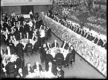
Photograph, Bull, Hugh Jones, 1897-1993, Lord Mayor's Dinner, Melbourne Town Hall
... After the separation of the colony in 1851, he became Victoria’s first surveyor-general... and advocated the provision of three-chain (60 m) roads and the widening of all existing main roads from one (20 m) to three chains." However, he was met with constant opposition and in 1853, was eased out of office. ...After the separation of the colony in 1851, he became Victoria’s first surveyor-general... and advocated the provision of three-chain (60 m) roads and the widening of all existing main roads from one (20 m) to three chains." However, he was met with constant opposition and in 1853, was eased out of office. ...Photographer notations on slide: "General View Of Lord Mayor's Dinner At Town Hall Nov 1936 B112" Published: The Age, Tuesday 10 November 1936, page 13 Published title: LORD MAYOR'S BANQUET Published caption: The brilliant scene inside the Melbourne Town Hall last night during the Lord Mayor’s banquet. Trove article identifier: http://nla.gov.au/nla.news-article205939431 Description: 700 guests (all men) are seated around numerous tables in the Melbourne Town Hall for the Lord Mayor's dinner in November 1936. Before the stage is a top table of 35 men, all dressed smartly in black dinner suits, with either a black or white bow tie. Many are wearing their medals. The Lord Mayor has on his Mayoral chains, and to his right is the Governor of Victoria, Lord Huntingfield. The stage is heavily decorated with fresh flowers. Research by project volunteer, Louise McKenzie: This image takes up one quarter of the photographic space on page 13 of The Age on 10 November 1936, reflecting the importance of the event and also the sheer dramatics of the image: 700 guests (all men), a top table of 35, and all dressed smartly in black dinner suits, with either a black or white bow tie. Many are wearing their medals. The Lord Mayor has on his Mayoral chains, and to his right is the Governor of Victoria, Lord Huntingfield. Further to his right is a man with an impressive sash across his chest. It is a very animated, and rather informal, moment. Banks of fresh flowers smother the stage, which is decorated in the manner of a terrace at an English stately home. Tables are laden with food, drink and decorations, and the wait staff (men and women) are also formally dressed, in the manner of Downton Abbey. It is spectacular, dramatic, and luxurious, and perpetuates the proud descriptor of “Marvellous Melbourne” as conferred by London Journalist George Augustus Sala when he visited the city in 1885. During its 1880s boom, Melbourne was the second-largest city in the British Empire, after London, and reputedly the richest city in the world. At times the expression was used with some irony, but "...in Victoria’s centenary year, 1934, with the city mired in another depression, a publisher bravely entitled a book of souvenir photographs Marvellous Melbourne, claiming that the subject ‘still finds apt expression in the happy one-time sobriquet’.” This photo seems to reflect an ongoing pride in Melbourne and a desire for it to live up to its descriptor and celebrate its post-centenary era in style. So it is no surprise to find that on page 11 of The Age on the same day, a second photo is to be found – a cropped view of one table – along with a very detailed description of the night, its purpose, and a surprise announcement. But, who was the Lord Mayor in whose honour the dinner was held? In 1934, the Lord Mayor of Melbourne was Cr. Alexander George Wales, (born Richmond, 11 October 1885, died Elsterwick, 31 May 1962). His father was a contractor and quarry-owner, but was blinded in an industrial accident in 1899. Consequently Alexander, then aged 14, left Brunswick State School to become a railway labourer working at a quarry, and in 1903 joined the Commonwealth public service as a clerk and began studying at night school, determined to improve himself. In 1907 he was appointed secretary of the Albion Quarrying Co. (in which the family had an interest), then its managing director and chairman. As the Australian Dictionary of Biography notes, he was instrumental in expanding the company’s interests, "...becoming director of the Hardware Co. of Australia Pty Ltd, the Twentieth Century Building and Investment Society, the Albion Sand Co. and the Geelong Brick Co.”. His public career began in 1914 when he was elected to the Brunswick council. He was mayor 1917-18, and in 1925 progressed to the Melbourne City Council where he remained for 29 years, being a member of most council committees. He served three successive terms as lord mayor (1934-37), was Chairman of the council’s decorations committee for Melbourne’s centenary, president of the Metropolitan Fire Brigades Board (1936), and Chairman of the Public Works Committee (1937-39). In 1936 he was elected to the Legislative Council with United Australia Party support, but later resigned over possible State government contract tender irregularities. Wales received "the customary reward” of a knighthood and was invested at Buckingham Palace by King George VI whose coronation he attended in 1937. He was an early director of what is now Ampol, and helped the development of the petroleum industry in Australia after visiting the USA in 1943 and 1946. He was impressed by that country’s wartime shipbuilding efforts and supported closer ties with the USA. “While president (1947-48) of the Melbourne Chamber of Commerce, Wales was a vocal critic of the Federal Labor Government, ...a staunch anti-socialist ... and a focus for conservative opposition to the Curtin and Chifley governments...” He is described as “a natural leader in business and civic politics,... a powerful force in the Melbourne City Council... opposing democratic reforms such as the creation of a Greater Melbourne Council and the abolition of plural voting, but advocat[ing] the redevelopment of city-owned property like the Eastern and Western markets...” So, this Lord Mayor’s dinner marks the third successive term in office for Governor Cr. A G Wales. The room is filled with powerful and influential men, and provided a platform for the Premier of Victoria, Albert Dunstan (1882-1950, United Country party) to announce that if the City Council would bear half the cost the State Government would build a bridge at Punt Road “at once”. He announced that the Government proposed to have the bridge built by the Country Roads Board, and allow the City Council to pay its share on convenient terms, and further, it would investigate the shared provision of more Yarra bridges. The proposal for the Punt Road Bridge was met with applause as the Yarra River constituted a serious traffic barrier. On 12 November 1936, two days after the Lord Mayor’s dinner, The Age published an article, “Building without a Plan”. It questions the appropriateness of the next Yarra bridge being the one at Punt Road, and encourages a “proper procedure” to look at the provision of additional Yarra bridges as a whole. But in fact this topic had been canvassed back in August when Melbourne City Council’s public works committee had recommended the replacement of the footbridge at Punt Road with a bridge, and if the Country Roads Board would declare this portion of Punt Road, including the river crossing, a State Highway, this could give the Board authority to construct the bridge and allocate the cost. Hence the reference at the dinner to a shared expense. Still an integral part of traffic management today, the Hoddle Bridge carries Punt Road over the Yarra River between Richmond and South Yarra in Melbourne. It is a five-lane road bridge with narrow footpaths on either side. It is of continuous reinforced concrete T-beam construction with five segmental arched spans, supported on transverse piers, and linked by concrete cross-beams. “The piers terminate in a series of tapered concrete pillars with Art Deco-styled steamlined decoration. Each pillar supports a Victorian-style lamp. The infill railings are geometric-patterned painted metal. Construction began in late 1937, and it was opened by Premier Albert Dunstan on 22 December 1938. It replaced an earlier footbridge, which in turn had replaced a punt service. The bridge (originally referred to as Punt Road Bridge) was named after Robert Hoddle, who planned central Melbourne’s Hoddle Grid, the grid of streets which form Melbourne’s central business district. Hoddle arrived in Australia from the UK in 1823 and went on to carry out surveys in NSW and Queensland before arriving in Melbourne in 1837. He designed layouts for both Melbourne and Williamstown, and later Geelong and other Victorian country areas. He was keen that major streets be at least 30 metres wide. ”With remarkable foresight he provided for wide boulevards from the city to the suburbs, but the subdivisions of early speculators in inner suburbs created the bottle-necks of today. After the separation of the colony in 1851, he became Victoria’s first surveyor-general... and advocated the provision of three-chain (60 m) roads and the widening of all existing main roads from one (20 m) to three chains." However, he was met with constant opposition and in 1853, was eased out of office. As a small and interesting aside: Hoddle was appointed auctioneer for the first sale of crown land in Melbourne on 1 June 1837. His commission was 57 pounds 12s 7d. and he bought two allotments for himself at a cost of 54 pounds. After he died his second wife married Richard Buckhurst Buxton, a member of the family which in 1860s Melbourne established the Australian property dynasty of Buxton Real Estate, Becton, MAB Corporation etc. Returning to the dinner and The Age article of 10 November 1836: Another topic of the after-dinner speeches was a reference to the upcoming Armistice Day. “The Minister of Customs (Mr White) said the proximity of Armistice day reminded us that eighteen years ago we had high hopes of prolonged peace.” The term “Armistice Day” was coined after WWI: “At 11 am on 11 November 1918, the guns on the Western Front fell silent after more than four years of continuous warfare. The Germans called for an armistice (suspension of fighting) in order to secure a peace settlement. They accepted the allied terms on unconditional surrender. Therefore on the 11th hour of the 11th day of the 11th month, a minute’s silence is observed and dedicated to those soldiers who died fighting to protect the nation. Originally known as Armistice Day, it was renamed Remembrance Day after World War Two to commemorate those who were killed in both World Wars. Today it refers to the loss of Australian lives from all wars and conflicts, accompanied by the words, "We will remember them, Lest we forget"." There was comment at the dinner about the need to remain firm in supporting the “democratic government in the British Empire to avoid a “plunge into savagery”. There was a grave responsibility on the British people to keep democracy alive, and that could not be done without adequate defence forces... Many weak governments in non-British countries had been swept aside by strong-fisted dictators, who now were the real threat to peace”. With the benefit of hindsight these were very pertinent comments and tragically prophetic. The Melbourne Shrine of Remembrance had only been dedicated two years earlier, at a ceremony attended by the Duke of Gloucester, son of King George V. Over 300,000 citizens attended: one third of the population of Melbourne. It became the location for the Anzac Day Dawn Service. Originally the march travelled from the Shrine into the city, however, in 1936, this was reversed, and the Shrine became the termination point for Anzac Day Marches. Also significant in 1936, was the installation of a statue in the west forecourt of the Shrine: “The Man with the Donkey” (aka 'Private John Simpson and his Little Donkey'). The work is said to represent the “valour and compassion of the Australian soldier”. Its full citation, according to the City of Melbourne City Collection is: West Side of Base: "The / Man with his Donkey / Gallipoli, April 25 to May 19 / in Commemoration / of the valour and compassion / of the Australian Soldier" AFTER LANDING AT GALLIPOLI, SIMPSON, WITH HIS LITTLE DONKEY, WORKED ALONE, DAY AND NIGHT TAKING WATER TO THE FRONT LINE AND CARRYING THE WOUNDED BACK TO THE DRESSING STATIONS. HE AND HIS DONKEY WERE KILLED BY A SHRAPNEL SHELL ON THE 19TH MAY, 1915. SIMPSON WAS MENTIONED IN DISPATCHES BY SIR IAN HAMILTON, COMMANDER-IN-CHIEF OF THE MEDITERRANEAN EXPEDITIONARY FORCE. / Erected by Public Subscription under auspices of the / Red Cross Society. East Side of Base: Private John Simpson." Their summary in background states: "A bronze figure of Simpson and his donkey with a wounded man on the donkey's back on a granite pedestal. Private John Simpson Kirkpatrick’s intrepid and short-lived exploits during the Gallipoli campaign have made him a popular figure of World War One. He has been mythologised to represent the lauded values of the digger, and he symbolises all those who went into battle unarmed. Born in England in 1892, he came to Australia in 1910. He enlisted to make his way back to England, but as a member of the 3rd Field Ambulance AIA was sent to Gallipoli. After just three weeks of bearing wounded soldiers across Shrapnel Gully on the back of his donkey, Simpson was killed by shrapnel fire. Simpson’s story became a powerful propaganda tool for enlistment in Australia, but following the war he was quickly forgotten. With the Shrine of Remembrance nearing completion in 1933, the memory of Simpson was rekindled to commemorate all who gave their lives to help others during the war. One plaque reads: ‘The / Man with his donkey / Gallipoli … / In commemoration / of the valour and compassion / of the Australian soldier’. In 1935, Wallace Anderson’s design for the memorial was selected though a competition organised by the Australian Red Cross. Anderson had served during the war and worked at the Australian War Memorial after his return. His Man with the Donkey was cast in Italy, and after some debate was sited near the shrine. Unveiled 20th June, 1936." The sculptor, Victorian-born William Wallace Anderson (1888-1975), served in France during WWI and afterwards produced a number of bronze war memorials and memorial portraits, predominantly in Victoria. “His most famous work is that of Simpson and his Donkey (1935), which he completed after winning a competition conducted by the Victorian Division of the Australian Red Cross. Anderson’s fee was 350 pounds; the cast, made by the Chiurazzi Foundry, Naples, Italy, cost 40 pounds. The work... has become well known as a symbol of the Anzac tradition.” A debate as to the siting of the statue arose from a strong view expressed by General Sir John Monash that no representation of individual members of the Australian Defence Force be located on the Shrine itself. Hence its location off to the northwest of the forecourt, in a garden of rosemary. And finally we return to the photo of the grand Lord Mayor’s dinner! An article in The Argus of 4 November 1936 refers to “Brilliant Scene at Lord Mayor’s Ball – Hall Becomes a Garden”. So now it becomes clear why the Town Hall, location of the Lord Mayor’s Dinner on 10 November 1934, only 6 days later, is so lavishly decorated. The floral decorations from the Ball are still in place - an early example of “recycling”, which is gratifying to note at a time of Depression. The reporter has captured the scene with enthusiasm: “Hundreds of tiny rose lights, hidden among pink roses, transformed the Melbourne Town Hall into a magical garden last night, when the Lord Mayor and Lady Mayoress (Councillor A. C. Wales, M.L.C., and Mrs. Wales) entertained about 3,500 guests at a ball. His Excellency the Governor (Lord Huntingfield) and Lady Huntingfield were present, while Rear-Admiral and Mrs. Lane Poole and officers from the visiting squadron were among the special guests. The balconies all round the hall were hidden by a white trellis, covered with pink blossoms and greenery. Rosy flowers were issued up every pillar, and great golden lamps, hanging from the door, were seated in greenery and trails of sweet peas. The organ gallery was converted into a terrace garden with stone steps leading to banks of pink azaleas, pink pelargoniums, masses of calceolarias, and the lovely deep mauve and blue of cinerarias. Slender Japanese maples and poplar trees grew from the higher slopes amid thickets of hostas, while a fascinating illusion was created by the lofty conservatory windows, which formed the background, and which were tinted cerulean blue to simulate the sky seen through glass. Large fern baskets hung from the conservatory roof, and the whole scene was enclosed in trellises of blossom. In the entrance palm green shrubs stood like sentinels round the passed floor, and flowers bloomed in misty golds. The long corridor upstairs leading to the council chamber was lined with an avenue of poplar trees in tubs. In the Lower Town Hall great banks of calceolarias and azaleas decked the upper dais, and each supper table was adorned with a different coloured flower with sprays of roses and Japanese maple laid on the snowy cloths. The adjoining supper-rooms were fragrant with the scent of huge bowls of stock in mauve, purple, and pink, while the white walls were covered with palm leaves and flowers. The roof garden below the clock tower was enclosed as a buffet with rose wreathed walls, and flowers were arranged attractively in the Lady Mayoress's rooms." References: LORD MAYOR'S BANQUET. CENTURY MAKERS AT THE M.C.G. BEFORE THE CHANGE. (1936, November 10). The Age (Melbourne, Vic. : 1854 - 1954), p. 13. Retrieved September 4, 2024, from http://nla.gov.au/nla.news-article205939431 'Portrait of Sir George Wales (Lord Mayor 1934-1937)', City Collection, City of Melbourne, https://citycollection.melbourne.vic.gov.au/portrait-of-sir-george-wales-lord-mayor-1934-37/ Graeme Davison, 'Marvellous Melbourne', eMelbourne, https://www.emelbourne.net.au/biogs/EM00906b.htm THE LORD MAYOR'S BANQUET. (1936, November 10). The Age (Melbourne, Vic. : 1854 - 1954), p. 11. Retrieved September 26, 2024, from http://nla.gov.au/nla.news-article205939643 BRILLIANT SCENE AT LORD MAYOR'S BALL Hall Becomes a Garden (1936, November 4). The Argus (Melbourne, Vic. : 1848 - 1957), p. 14. Retrieved September 26, 2024, from http://nla.gov.au/nla.news-article11932746 'Hoddle Bridge', Wikipedia, https://en.wikipedia.org/wiki/Hoddle_Bridge 'Hoddle Bridge', Victorian Heritage Database Report, Victorian Heritage Council, https://vhd.heritagecouncil.vic.gov.au/places/195689/download-report David Dunstan, 'Wales, Sir Alexander George (1885–1962)', Australian Dictionary of Biography, National Centre of Biography, Australian National University, https://adb.anu.edu.au/biography/wales-sir-alexander-george-8951/text15737, published first in hardcopy 1990, accessed online 26 September 2024. Marjorie J. Tipping, 'Hoddle, Robert (1794–1881)', Australian Dictionary of Biography, National Centre of Biography, Australian National University, https://adb.anu.edu.au/biography/hoddle-robert-2190/text2823, published first in hardcopy 1966, accessed online 26 September 2024. BUILDING WITHOUT A PLAN. (1936, November 12). The Age (Melbourne, Vic. : 1854 - 1954), p. 8. Retrieved September 26, 2024, from http://nla.gov.au/nla.news-article205949762 NEW BRIDGE AT PUNT ROAD (1936, August 12). The Argus (Melbourne, Vic. : 1848 - 1957), p. 10. Retrieved September 26, 2024, from http://nla.gov.au/nla.news-article11902131 'The Shrine of Remembrance', Beaconsfield’s Soldiers: https://beaconsfield.org.au/digitalmemorial/shrine-introduction/ 'Shrine of Remembrance', Wikipedia, https://en.wikipedia.org/wiki/Shrine_of_Remembrance Ken Scarlett, 'Anderson, William Wallace (1888–1975)', Australian Dictionary of Biography, National Centre of Biography, Australian National University, https://adb.anu.edu.au/biography/anderson-william-wallace-9362/text16441, published first in hardcopy 1993, accessed online 26 September 2024. 'Man with the Donkey', City Collection, City of Melbourne, https://citycollection.melbourne.vic.gov.au/man-with-the-donkey-aka-private-john-simpson-and-his-little-donkey/ 'Remembrance Day', Australian Army, https://www.army.gov.au/about-us/history-and-research/traditions/remembrance-day Photographer notations on slide: "General View Of Lord Mayor's Dinner At Town Hall Nov 1936 B112".melbourne town hall, mayors, lord mayors, centenaries, bridges, dinners, clothing and dress, festive decorations, dances and balls, eating and drinking, shrine of remembrance, governors, monuments and memorials, 1930-1939, plants -
 Victorian Aboriginal Corporation for Languages
Book, Sue Wesson et al, Aboriginal flora and fauna names of Victoria : as extracted from early surveyors' reports, 2001
... Office. This first stage of the project focussed on the NRE archives, in particular the field notebooks of the earliest surveyors and their maps although other NRE resources, libraries and public records were accessed. A total of 3028 words were found of which a significant proportion have previously been unknown to linguists. It appears that the place names and word lists in early surveyors notebooks, the 1858 surveyors responses to the Surveyor General...Office. This first stage of the project focussed on the NRE archives, in particular the field notebooks of the earliest surveyors and their maps although other NRE resources, libraries and public records were accessed. A total of 3028 words were found of which a significant proportion have previously been unknown to linguists. It appears that the place names and word lists in early surveyors notebooks, the 1858 surveyors responses to the Surveyor General ...The Flora and Fauna Names Project is an initiative of the Victorian Aboriginal Corporation for Languages and the Victorian Biodiversity Strategy. The researcher has examined material from the archives of the Department of Natural Resources and Environment (NRE), the State Library of Victoria, the Victorian Public Records Office and the Australian Archives Office. This first stage of the project focussed on the NRE archives, in particular the field notebooks of the earliest surveyors and their maps although other NRE resources, libraries and public records were accessed. A total of 3028 words were found of which a significant proportion have previously been unknown to linguists. It appears that the place names and word lists in early surveyors notebooks, the 1858 surveyors responses to the Surveyor General and an extensive Wiradjuri wordlist by James Baylis have not yet been widely used or published. Fifteen percent of these 3028 words describe flora and fauna and six percent describe habitat. Of particular interest is the evidence provided by these lists of the existence of fauna in the mid nineteenth century in regions where it is now extinct. For example, magpie geese, eastern quolls, bustards and pademelons were assigned names in the Jardwadjali language area of the upper Glenelg and Wimmera Rivers. The outcomes of this project may help to assist in ascertaining the distribution of flora and fauna assets in Victoria.maps, b&w photographs, colour photographs, illustrations, word listswiradjuri, jardwadjali, glenelg river, wimmera river -
University of Melbourne, Burnley Campus Archives
Map (item), Proposed Reserve for Horticultural & Experimental Garden in the Survey Paddock. Clement Hodgkinson Deputy Surveyor General, 1862
... University of Melbourne, Burnley Campus Archives 500 Yarra Boulevard Richmond melbourne Horticultural & Experimental Garden Survey Paddock Clement Hodgkinson Coloured printout of map in Public Record Office Victoria (VPRS 8168) Proposed Reserve for Horticultural & Experimental Garden in the Survey Paddock. Clement Hodgkinson Deputy Surveyor General Map ...horticultural & experimental garden, survey paddock, clement hodgkinson -
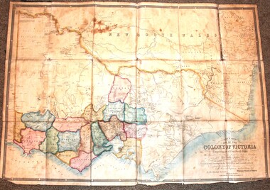 Wodonga & District Historical Society Inc
Map - Tulloch & Brown's Map of the Colony of Victoria, Tulloch & Brown, 1856
... Office and correctly revised till 1857. Respectfully dedicated by Permission, to the Honorable Captain Andrew Clarke R.E. Surveyor General...Office and correctly revised till 1857. Respectfully dedicated by Permission, to the Honorable Captain Andrew Clarke R.E. Surveyor General ...The map was created by Tulloch and Brown. David Tulloch was one of the earliest engravers and lithographers in the state of Victoria. He arrived in Melbourne from Greenock, Scotland, on 3 January 1849. Following the discovery of gold Tulloch went to the Victorian goldfields in 1851, commissioned to make sketches of the diggers and the diggings for Ham’s Illustrated Australian Magazine. In November 1852 Tulloch set up in business as engraver, draughtsman, copperplate printer and lithographer. Tulloch took a map engraver, James Davie Brown, into partnership in March 1853; the several maps and specimens of commercial engraving they showed at the 1854 Melbourne Exhibition were awarded a bronze medal. That year Tulloch and Brown also received a silver medal at the Victorian Industrial Exhibition. The partnership was dissolved towards the end of 1856.This is a very early map of the Colony of Victoria including Belvoir (now know as Wodonga).A foldable map mounted on linen and with a board cover. It records the Colony of Victoria according to Surveyor's Records revised in 1857. Areas of the map are shaded to highlight different counties.At bottom right hand section of map: Tulloch & Brown's map of the Colony of Victoria : comprising part of New South Wales, the boundaries, counties, also seaport & inland townships, the gold fields with the latest discoveries, roads, tracks, &c. &c. / compiled from drawings in the Survey Office and correctly revised till 1857. Respectfully dedicated by Permission, to the Honorable Captain Andrew Clarke R.E. Surveyor General of Victoria by His Obediant Servants Tulloch & Brown, Engravers & Publishers, Melbourne". At bottom right below border : Published as the Act directs by the Proprietors, Melbourne, 1st Feb. 1856. tulloch and brown maps, rare maps victoria, victorian cartography -
Whitehorse Historical Society Inc.
Map, Plan of the Parish of Nunawading, 1853
... Parmein, Surveyor General's Office Nov 30, 1853 also Reference to the Corners of allotments' (Plan 428)...Parmein, Surveyor General's Office Nov 30, 1853 also Reference to the Corners of allotments' (Plan 428)...Parmein, Surveyor General's Office Nov 30, 1853 also Reference to the Corners of allotments' (Plan 428) Land Subdivision Gardiners Creek Ballyshanassy Parmein H Burwood East Maps Photocopy of map showing names of selectors, also list of references to the corners of allotments. ...Photocopy of map showing names of selectors, also list of references to the corners of allotments.Photocopy of map showing names of selectors, also list of references to the corners of allotments. Note on verso:'Gardiners Creek, Ballyshanassey township surveyed by H. Parmein, Surveyor General's Office Nov 30, 1853 also Reference to the Corners of allotments' (Plan 428)Photocopy of map showing names of selectors, also list of references to the corners of allotments. land subdivision, gardiners creek, ballyshanassy, parmein, h, burwood east, maps -
Whitehorse Historical Society Inc.
Map, The Parish of Nunawading, 1853
... Note on verso: The Parish of Nunawading in the County of Bourke; lithographed at the Surveyor General's office by J.Jones Jan 18th 1853. ...Note on verso: The Parish of Nunawading in the County of Bourke; lithographed at the Surveyor General's office by J.Jones Jan 18th 1853. ...Whitehorse Historical Society Inc. 2-10 Deep Creek Road Mitcham melbourne Note on verso: The Parish of Nunawading in the County of Bourke; lithographed at the Surveyor General's office by J.Jones Jan 18th 1853. Endorsed Sale Plan 271. ...Photocopy of manuscript plan with allotments numbered and some named.Photocopy of manuscript plan with allotments numbered and some named. Note on verso: The Parish of Nunawading in the County of Bourke; lithographed at the Surveyor General's office by J.Jones Jan 18th 1853. Endorsed Sale Plan 271. Dray tracks, water holes and terrain indicated.Photocopy of manuscript plan with allotments numbered and some named. land subdivision, maps, parish of nunawading, jones, j -
Whitehorse Historical Society Inc.
Map, Parish of Nunawading, 1853
... Parmein, Surveyor General's office, Nov 30th 1853 [enlargement of ND 2801, no list of corner references]...Parmein, Surveyor General's office, Nov 30th 1853 [enlargement of ND2801, no list of corner references]...Parmein, Surveyor General's office, Nov 30th 1853 [enlargement of ND 2801, no list of corner references] Maps Gardiners Creek Ballyshanassy Burwood East Parmein H Photocopy of manuscript map with allotments numbered and named. ...Photocopy of manuscript map with allotments numbered and named.Photocopy of manuscript map with allotments numbered and named. Note on verso: Parish of Nunawading, County of Bourke. Gardiners Creek, Ballyshanassey Township, surveyed by H. Parmein, Surveyor General's office, Nov 30th 1853 [enlargement of ND2801, no list of corner references]Photocopy of manuscript map with allotments numbered and named. maps, gardiners creek, ballyshanassy, burwood east, parmein, h -
University of Melbourne, Burnley Campus Archives
Plan - Photocopy, Proposed Reserve for Horticultural and Experimental Garden in the Survey Paddock Richmond, 1862-1948
... Surveyor General. Stamped Department of Lands and Survey 7.12.48 Neg.18377. Handwritten notes on back "Melb Roll 23, R.19(A)" Photocopy of Plan Gazetted 01.08.1863. From Central Plan Office ...Photocopy of Plan Gazetted 01.08.1863. From Central Plan Office Department of Natural Resources.Original signed by Clement Hodgkinson, Deputy Surveyor General. Stamped Department of Lands and Survey 7.12.48 Neg.18377. Handwritten notes on back "Melb Roll 23, R.19(A)"burnley, horticultural and experimental garden, survey paddock, richmond, clement hodgkinson -
Tarnagulla History Archive
Photocopies: Historical Tarnagulla letters, 1859-1874
... office newbridge racecourse cemetery thomson comrie Photocopies of seven historical handwritten letters associated with Tarnagulla. Original letters are all 19th Century. Whereabouts of originals unknown. Copies probably made by Murray Comrie in the 1960s. 1. Character reference for David Renshaw written by Thomson & Comrie (1874?) - 1 copy 2. Letter to Melbourne Postmaster from William ______ about an advertisement (1860) - 3 copies 3. Two page letter from John Papineau of Sandy Creek to the Surveyor General ...Murray Comrie Collection. Photocopies of seven historical handwritten letters associated with Tarnagulla. Original letters are all 19th Century. Whereabouts of originals unknown. Copies probably made by Murray Comrie in the 1960s. 1. Character reference for David Renshaw written by Thomson & Comrie (1874?) - 1 copy 2. Letter to Melbourne Postmaster from William ______ about an advertisement (1860) - 3 copies 3. Two page letter from John Papineau of Sandy Creek to the Surveyor General regarding gazetting of land for a racecourse 3 miles from Newbridge next to the Loddon, and further gazetting to protect cemetery area at Tarnagulla from gold miners. (August 1859) Original may be in Lands Dept - 2 copies 4. Letter from the Postmaster Sandy Creek to same at Melbourne regarding daily mail despatch times (March 1860) - 3 copies 5. Letter to the Mayor and Councillors of the Borough of Tarnagulla from Prince Alfred? thanking them for welcoming him during his visit (1867). Original may be in Hall. - 3 copies 6. Letter to the Dept of Lands and Survey, Melbourne from John Papineau of Sandy Creek. States that he has enclosed a copy of his August 2nd letter. (1859) - 4 copies 7. Letter to David Renshaw from Parliament House. Appears to be a character reference. Dated 3rd October 1874 - 2 copies of page 1 only, no second page. tarnagulla, residents, renshaw, papineau, post office, newbridge, racecourse, cemetery, thomson, comrie -
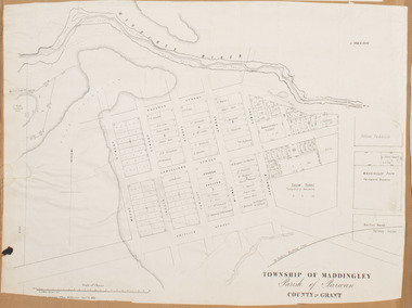 Bacchus Marsh & District Historical Society
Map, Maddingley Township, Parish of Parwan, 1880s
... Bottom of Map: Surveyor-General's Office, Melbourne, Sept 6th, 1856...Bacchus Marsh Victoria Maps Maddingley Victoria Maps Land Use Maddingley Victoria History Bottom of Map: Surveyor-General's Office, Melbourne, Sept 6th, 1856 A single page paper map showing land allotments, streets, rivers, creeks, park lands, the railway line and Bacchus Marsh railway station in the township of Maddingley. ...This map is dated Sept. 6th 1856. However places in the township of Maddingley which did not appear until the late 1880s such as the Bacchus Marsh Railway Station and line are shown on this map in their correct locations. This suggests the map has been derived from an earlier map. An earlier date of 1843 with a surveyor's name preceding it can also be seen on the map. The map is important because it indicates the location and dimensions of early but now discontinued use of land such as the showgrounds and police paddock and a site reserved for the Church of England which was not ultimately used for a permanent church. A single page paper map showing land allotments, streets, rivers, creeks, park lands, the railway line and Bacchus Marsh railway station in the township of Maddingley. The map is pasted into a bound volume containing 76 maps or plans in total. Bottom of Map: Surveyor-General's Office, Melbourne, Sept 6th, 1856bacchus marsh victoria maps, maddingley victoria maps, land use, maddingley victoria history -
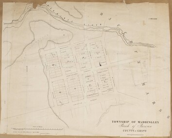 Bacchus Marsh & District Historical Society
Map, Maddingley Township, Parish of Parwan, County of Grant, 1856
... Skene Surveyor, 1843. ; 2. Surveyor-General's Office Melbourne, Sept 6, 1856. (Lithographed by R. ...Skene Surveyor, 1843. ; 2. Surveyor-General's Office Melbourne, Sept 6, 1856. (Lithographed by R. ...Maddingley is a locality or township within the broader township area of Bacchus Marsh. This map is dated 1856 but is based on an earlier survey in 1843. The main area of Maddingley shown on this map is an area bounded by Bacchus Street, Moore Street, Griffith Street and Franklin Street. Other streets visible are Inglis Street, Labilliere Street, McCrae Street. The area to the east of Franklin Street is not sub-divided and is described as an 'alluvial flat. A single page paper map showing land allotments, streets, and natural watercourses in the township of Maddingley. The map is pasted into a bound volume containing 76 maps or plans in total. Two inscriptions: 1. A.J. Skene Surveyor, 1843. ; 2. Surveyor-General's Office Melbourne, Sept 6, 1856. (Lithographed by R. Meikle)bacchus marsh victoria maps, maddingley victoria maps, land use, maddingley victoria history -
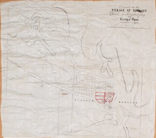 Bacchus Marsh & District Historical Society
Map, Allotments in the Village of Rowsley, Parish of Gorrocburkghap, County of Grant c.1856
... Nixon, Assistant Surveyor, May 1856 ; Surveyor General’s Office, July 18 1856 (lithographed by R. ...Nixon, Assistant Surveyor, May 1856 ; Surveyor General’s Office, July 18 1856 (lithographed by R. ...Rowsley is a locality 11 kilometers south-west of Bacchus Marsh. The date of this map is uncertain. A very similar map held by the State Library of Victoria (SLV) contains slightly more information than this copy and is dated as an 1856 map. SLV reference: 'Allotments in the Village of Rowsley, Parish of Gorrocburkghap, County of Grant', by T. Nixon, Assistant Surveyor, May 1856 ; Surveyor General’s Office, July 18 1856 (lithographed by R. Meikle). (1856). Melbourne: Surveyor General’s Office. MAPS 820 BJE 1837- ROWSLEY 1856. A single page paper map. A cadastral map of the Village of Rowsley in Victoria, showing numbered land allotments. 57 allotments are shown on the map and some areas set aside as reserves. Allotments 8, and 10-16 are outlined in red ink and allotment 9 has a cross in red ink on it. The map is pasted into a bound volume containing 76 maps or plans in total. High resolution digital image stored on BMDHS computer network. rowsley victoria history, rowsley victoria maps