Showing 12333 items matching " plan."
-
 Greensborough Historical Society
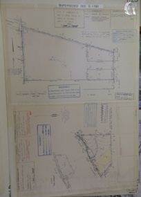
Planning document, Subdivision Plan #1128. St Helena Road Greensborough, 1985_
... Subdivision Plan #1128. St Helena Road Greensborough....(superseded plan)...Plan (2 sheets) mounted on heavy card....Notation: 'Superseded plan see G1190'...(superseded plan) An example of hard copy subdivision plans from the Greensborough area. ...Plan of Subdivision for property at St Helena Road. (superseded plan)An example of hard copy subdivision plans from the Greensborough area. Mainly from the Shire of Diamond Valley era (1964-1994).Plan (2 sheets) mounted on heavy card.Stamped and handwritten Council permissions, dates and other details. Notation: 'Superseded plan see G1190'subdivision plans, st helena road -
 National Wool Museum
Plan, Plan of Drainage for Dennys Lascelles Ltd
... Plan...Plan of Drainage for Dennys Lascelles Ltd...Plan for alterations to the drainage and plumbing of the Dennys Lascelles wool store (current building and demolished building)....Drainage plan for Dennys Lascelles building, c.1920s. ...PLAN OF DRAINAGE / for / Dennys Lascelles Lim. / (Messrs Laird & Buchan, Agents) / MUNICIPALITY: CITY OF GEELONG...Plan of Drainage for Dennys Lascelles Ltd Plan ...Plan for alterations to the drainage and plumbing of the Dennys Lascelles wool store (current building and demolished building).Drainage plan for Dennys Lascelles building, c.1920s. Detail of drainage plan for Dennys Lascelles building, c.1920s.PLAN OF DRAINAGE / for / Dennys Lascelles Lim. / (Messrs Laird & Buchan, Agents) / MUNICIPALITY: CITY OF GEELONGwool stores, dennys, lascelles limited laird and buchan, plans -
 Greensborough Historical Society
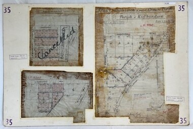
Poster - Planning Document, City of Heidelberg, Subdivision Plan # 35 - Parish of Keelbundoora, Crown Portion 16, Watsonia, 1918
... Subdivision Plan # 35 - Parish of Keelbundoora, Crown Portion 16, Watsonia...Subdivision Plan # 35 Parish of Keelbundoora, Crown Portion 16: 3 plans on one sheet. ...3 Plans (single sided) mounted on heavy card. ...Stamped and handwritten Council permissions, dates and other details. Plan 1 has been stamped in red "SUPERCEDED" and overwritten by hand "Cancelled"....Plan 2: an update of plan 1. Plan 3: Also Lambourn Road, Boger Street, Kenmare Street, dated 1918, Shire of Heidelberg. ...Subdivision Plan # 35 Parish of Keelbundoora, Crown Portion 16: 3 plans on one sheet. Plan 1: Lambourn Road, Boger Street, Kenmare Street, Greensborough Road, Devonshire Road, Watsonia (stamped "Superseded"). Plan 2: an update of plan 1. Plan 3: Also Lambourn Road, Boger Street, Kenmare Street, dated 1918, Shire of Heidelberg.An example of hard copy subdivision plans from the Greensborough area. Mainly from the Shire of Diamond Valley era (1964-1994).3 Plans (single sided) mounted on heavy card. Stamped and handwritten Council permissions, dates and other details. Plan 1 has been stamped in red "SUPERCEDED" and overwritten by hand "Cancelled".subdivision plans, city of heidelberg, greensborough, main street greensborough, shire of heidelberg, watsonia -
 Friends of Ballarat Botanical Gardens History Group
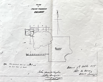
Work on paper - Site of the Ballarat Botanical Gardens, Plan of Police Paddock, Ballarat, 6th October 1855, October, 1855
... Plan of Police Paddock, Ballarat, 6th October 1855......plan...Plan of Police Paddock, Ballarat, 6th October 1855....One large white sheet of paper photocopied and folded with a black margin at either end, and the plan and printing in longhand....The Plan is signed and dated by the Acting Surveyor and Assistant Surveyor, October, 1855....The Plan is signed and dated by the Acting Surveyor and Assistant Surveyor, October, 1855. ...Plan of Police Paddock, Ballarat, 6th October 1855.In 1855, the Police Paddock occupied the land of the present Ballarat Botanical Gardens.One large white sheet of paper photocopied and folded with a black margin at either end, and the plan and printing in longhand.The Plan is signed and dated by the Acting Surveyor and Assistant Surveyor, October, 1855.john garner collection, garner, dr, police, paddock, plan, map, 1855, ballarat botanical gardens, ballarat, gardens, wendouree, swamp. -
 Buninyong & District Historical Society
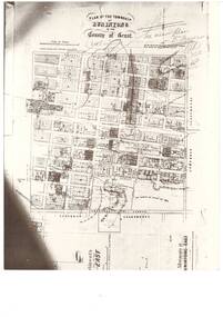
Photograph - Black and white photograph of Plan of the Township of Buninyong, Plan of the Township of Buninyong in the County of Grant March 18 1856
... Plan of the Township of Buninyong in the County of Grant March 18 1856...A photograph of the Plan of the Township of Buninyong from the Surveyor Generals Office Melbourne March 1856...A black and white photograph showing the Plan of the Township of Buninyong..."Plan of the Township of Buninyong County of Grant", Surveyor Generals Office Melbourne 18th March 1856, various handwritten notations...A photograph of the Plan of the Township of Buninyong from the Surveyor Generals Office Melbourne March 1856 The map is one of the earliest of Buninyong and shows some notations indicating some allocations of land that were revoked and possibly the location of tannery dam Buninyong Township Maps "Plan of the Township of Buninyong County of Grant", Surveyor Generals Office Melbourne 18th March 1856, various handwritten notations A black and white photograph showing the Plan of the Township of Buninyong Plan of the Township of Buninyong in the County of Grant March 18 1856 Photograph Black and white photograph of Plan of the Township of Buninyong ...A photograph of the Plan of the Township of Buninyong from the Surveyor Generals Office Melbourne March 1856The map is one of the earliest of Buninyong and shows some notations indicating some allocations of land that were revoked and possibly the location of tannery damA black and white photograph showing the Plan of the Township of Buninyong"Plan of the Township of Buninyong County of Grant", Surveyor Generals Office Melbourne 18th March 1856, various handwritten notationsbuninyong township, maps -
 Flagstaff Hill Maritime Museum and Village
Document - Plan, Victorian Harbours Warrnambool, Victorian Harbours, Warrnambool, Plan to Accompany Sir John Coode's Report, 28-02-1879
... Plan...Victorian Harbours, Warrnambool, Plan to Accompany Sir John Coode's Report......plan...His original plan was too expensive so he prepared a revised plan for a shorter structure. ...Plan of Warrnambool Harbour, Port of Warrnambool, dated 28 Feb 1879. ...Stamped "VICTORIAN HARBOURS / WARRNAMBOOL / PLAN / to accompany / SIR JOHN GOODE'S REPORT / DATED 28 FEB 1879" Signature "John Coode"...His original plan was too expensive so he prepared a revised plan for a shorter structure. ...This plan is of great significance to the local history of Warrnambool, in particular the Breakwater and its impact on Warrnambool's maritime and trade history. The plan shows the existing jetties at the Port of Warrnambool, plus the partially erected Breakwater and proposed works to the Breakwater by both the Borough of Warrnambool Surveyor and Sir John Coode. The plan was signed 28th February 1879 by Sir John Coode. The legend at the bottom left describes the existing works and the proposed works. The Warrnambool Breakwater Sir John Coode was a British harbour engineer. He was brought to Melbourne by the Melbourne Harbour Trust to advise on works to improve the Port of Melbourne. The Victorian Government commissioned him to present a plan to complete the Warrnambool Breakwater. His original plan was too expensive so he prepared a revised plan for a shorter structure. The work was completed in 1890. The construction proved to be too short to protect adequately from the weather and didn't allow enough depth for larger vessels to come into port. The decreasing trade was further affected by siltation in the bay due to the breakwater, and the completion of the railway line. The situation of the harbour became a real problem that, by 1910, required continuous dredging. In 1914 the Breakwater was extended but proved to be a failure because the work began to subside and by 1920 about two thirds of the harbour was silted up. Alterations made in the 1920's increased the silting problem and by the 1940's the harbour was no longer used. More alterations were made in the 1950's and 1960's. The Warrnambool Breakwater is registered as a place of significance on the Victorian Heritage Database. This plan of the proposed works for the existing Warrnambool Breakwater is of great significance to the local history of Warrnambool, in particular the Breakwater and its impact on Warrnambool's maritime and trade history. The Warrnambool Breakwater is registered as a place of significance on the Victorian Heritage Database (VHR H2024). It is historically significant to Victoria as one of the most important maritime engineering projects in Victoria in the late 19th century. The Warrnambool Breakwater is of historical significance as one of the most important maritime engineering projects in Victoria in the late nineteenth century. It is evidence of Victoria's nineteenth century investment in regional port infrastructure and the development of Victorian coastal shipping. It is of significance for its association with the English civil engineer Sir John Coode, the most distinguished harbour engineer of the nineteenth century, who was brought to Victoria to advise on works to improve the Port of Melbourne, but was retained by the Government to advise on improvements to the harbours at Portland, Geelong, Port Fairy, and Lakes Entrance, as well as Warrnambool. His projects for Melbourne, Lakes Entrance and Warrnambool were major engineering projects of the nineteenth century. The breakwater is historically significant as a reminder of Warrnambool's early maritime history as a Western District port, and as one of Victoria's major 'outer ports'. While the Warrnambool Breakwater is a demonstration of the engineering skills of the nineteenth century, it also demonstrates the limitations of knowledge relating to sedimentology at the time and the confidence apparent in a number of nineteenth century plans which assumed that natural forces could be overcome or contained by engineering.Plan of Warrnambool Harbour, Port of Warrnambool, dated 28 Feb 1879. Plan shows existing Breakwater and work proposed by both Warrnambool Borough Surveyor and Sir John Coode. Plan has gold coloured quarter-dowel rods top and bottom and a metal ring at the top. Stamped with title. Signed by Sir John Coode.Stamped "VICTORIAN HARBOURS / WARRNAMBOOL / PLAN / to accompany / SIR JOHN GOODE'S REPORT / DATED 28 FEB 1879" Signature "John Coode"flagstaff hill, warrnambool, maritime museum, shipwreck coast, great ocean road, sir john coode, borough of warrnambool surveyor, plan of warrnambool, victorian harbours, warrnambool harbour, warrnambool breakwater, port of warrnambool, vhd vhr h2024, flagstaff hill maritime museum & village, maritime village, map, chart, plan, lady bay, breakwater, jetty, pier, vhr h2024, proposed works, 1879 -
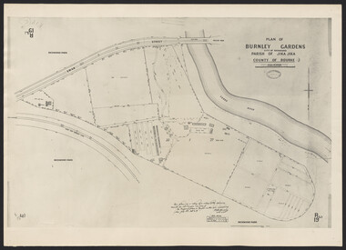
 University of Melbourne, Burnley Campus Archives
Map, Melbourne and Metropolitan Board of Works Plan No. 42 Richmond, c.1884-1891
... Melbourne and Metropolitan Board of Works Plan No. 42 Richmond ...Photocopy of Melbourne and Metropolitan Board of Works Plan No 42 M 387 ₍₄₂₎ of Richmond from plans dated c1884-1891. ...Original stamped "Original Plan Room"...University of Melbourne, Burnley Campus Archives 500 Yarra Boulevard Richmond melbourne melbourne and metropolitan board of works richmond Burnley Gardens Richmond Park Original stamped "Original Plan Room" Photocopy of Melbourne and Metropolitan Board of Works Plan No 42 M 387 ₍₄₂₎ of Richmond from plans dated c1884-1891. ...Photocopy of Melbourne and Metropolitan Board of Works Plan No 42 M 387 ₍₄₂₎ of Richmond from plans dated c1884-1891. Shows A. Lynch's Plan of the Gardens. Scale 160 ft. to 1 inchOriginal stamped "Original Plan Room"melbourne and metropolitan board of works, richmond, burnley gardens, richmond park -
 Bacchus Marsh & District Historical Society
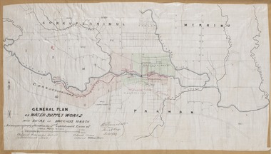
Map, General Plan for Water Supply Works, Shire of Bacchus Marsh 1887
... General Plan for Water Supply Works, Shire of Bacchus Marsh 1887...The plan includes the route of a proposed water channel in the Parwan area, and other features of water supply infrastructure such as the location of standpipes and gates are also shown on the plan....A single page paper map showing a general plan for the supply of water in the Bacchus Marsh area.The plan shows the route of the 'Main Channel' near the Werribee River and a proposed route for a Parwan Channel. ...General Plan of Water Supply Works in the Shire of Bacchus Marsh. ...The plan includes the route of a proposed water channel in the Parwan area, and other features of water supply infrastructure such as the location of standpipes and gates are also shown on the plan. ...Debate about water supply and its planning and development took place in the Bacchus Marsh region from the 1850s through into the twentieth century. This plan was part of documentation to support an application for an additional loan of money from the Ministry of Water Supply to the Bacchus Marsh Shire Water Supply Trust. The plan includes the route of a proposed water channel in the Parwan area, and other features of water supply infrastructure such as the location of standpipes and gates are also shown on the plan.A single page paper map showing a general plan for the supply of water in the Bacchus Marsh area.The plan shows the route of the 'Main Channel' near the Werribee River and a proposed route for a Parwan Channel. The location of 'Dryden's House' near the Werribee River is also shown and the locations of land held by T. (Tom) Oliver and the Racecourse Reserve in Maddingley. Scale 40 chains to 1 inch. The plan is signed by Bacchus Marsh Shire Engineer, W.E. Standfield. The map is pasted into a bound volume containing 76 maps or plans in total. High resolution digital image stored on BMDHS computer network. General Plan of Water Supply Works in the Shire of Bacchus Marsh. Accompanying application for 2nd additional Loan. Original Waterworks district. Additional area. W.E. Standfield, 30/8/87.water supply, water supply maps, water supply bacchus marsh, irrigation, bacchus marsh victoria maps -
 Warrnambool and District Historical Society Inc.
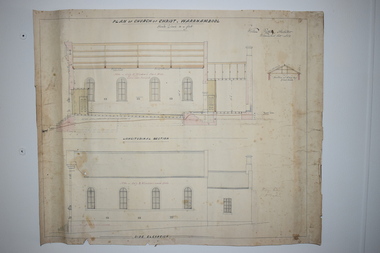
Document, Plan of Church of Christ Warrnambool, 1883
... Plan of Church of Christ Warrnambool... These plans have been drawn up in 1883 by the Warrnambool architect, William Patterson. ...These are two sheets of cream-coloured thick paper with scaled drawings of plan sections of the Church of Christ in Warrnambool. ...‘Plan of Christ Church Warrnambool’...The plans have come from the present-day Warrnambool Church of Christ. ...These plans have been drawn up in 1883 by the Warrnambool architect, William Patterson. They show six sections of plans for the erection of a Church of Christ at 12 Spence Street Warrnambool. The mason was William Kellas and the builder was Harold Dawkins. Church of Christ adherents began meeting in Warrnambool in 1875 and bought land in Spence Street in 1877. The church was opened in 1885 with visiting pastors until a resident minister, A. J. Fisher, was appointed in 1915. This church was closed early in the 21st century when a new church, Gateway Church of Christ, was opened in Ragland Parade in Warrnambool. These plans are of great interest as original ones of the Church of Christ In Spence Street Warrnambool. The plans have come from the present-day Warrnambool Church of Christ. The building still exists but is no longer is use as a church. These are two sheets of cream-coloured thick paper with scaled drawings of plan sections of the Church of Christ in Warrnambool. The drawings are in black ink with some sections coloured in. Both pages have a black line margin drawn around the edges. The pages are torn at the edges in several places and the sheets are much stained. The sheets have been reinforced at the back (left side) with thick brown paper.‘Plan of Christ Church Warrnambool’plans church of christ warrnambool, william kellas, harold dawkins warrnambool -
Robin Boyd Foundation
Document - Receipt, Foster Parents Plan of Australia, Foster Parents, April and May 1971
... Two receipts paid by Robin Boyd to Foster Parents Plan of Australia for $14.50 in April and May 1971....Foster Parents Plan of Australia...Foster Parents Document Receipt Foster Parents Plan of Australia ...Two receipts paid by Robin Boyd to Foster Parents Plan of Australia for $14.50 in April and May 1971.Green slips, two pages each. -
 Flagstaff Hill Maritime Museum and Village
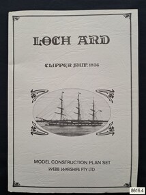
Document - Ship Model Plans, Webb Warships Pty Ltd, Loch Ard Clipper Ship, 1874; Model Construction Plan Set, 1978
... Loch Ard Clipper Ship, 1874; Model Construction Plan Set...The plans are presented in a keepsake folder. They show marks of sections copied and assembled together. ...Model ship plans for building the LOCH ARD. The three sets of plans are presented in a textured cream card folder with the supplier’s details and an oval cameo drawing of the LOCH ARD. ...On Folder: "LOCH ARD CLIPPER SHIP, 1874, MODEL CONSTRUCTION PLAN SET, WEBB WARRIORS PTY LTD." "CONTENTS COPYRIGHT (C) 1978, WEBB WARSHIPS PTY LTD" "WEBB WARSHIPS PTY LTD, PO BOX 50, WILLIAMSTOWN, VICTORIA 3016, AUSTRALIA" Handwritten inscription on sheet 3: "834" "THE FLOATING DRYDOCK, PO BOX 16066, PHILADELPHIA, PENNA. 14114, USA" "SAMBROOK MARINE (PLANS), 84 BROAD ST. ...Loch Ard Clipper Ship, 1874; Model Construction Plan Set Document Ship Model Plans Webb Warships Pty Ltd ...The plans are presented in a keepsake folder. They show marks of sections copied and assembled together. Overall, the plans are similar to those drawn by Mr P Webb to the order of the Loch Ard Shipwreck Centenary through Mr P Williams, the organizer of the Centenary competition. “The details were based on all available information which resulted in considerable historical research…and received favourable comment from model makers because of their attention to detail…In excess of 650 sets of plans were sold before entries closed…Many plans were probably purchased by collectors and interested persons for historical reference. An illustrated historical story sheet…was prepared and enclosed with the plans…” (‘Loch Ard Shipwreck Centenary 1878-1978 Report’, November 1978). An example of the attention to historical detail on the plans is the inclusion of the following useful information about the original vessel … Tonnage….1,693 G.R.T., 1,624 N.R.T. Dimensions, Builders….Charles Connell & Co., Ltd., Scotstoun, 1873. Owners….General Shipping Co., Glasgow, (Aitken Lilburn & Co., Ltd.), and the ship’s fate. The plans, in conjunction with the scale Ship Model of the LOCH ARD also on display, are of interpretive significance to Flagstaff Hill Maritime Village. The plans provide historical and technological context to artefacts from the shipwreck, increasing understanding and appreciation of those objects. Flagstaff Hill’s collection of artefacts from LOCH ARD is significant for being one of the largest collections of artefacts from this shipwreck in Victoria. It is significant for its association with the shipwreck, which is on the Victorian Heritage Register (VHR S417). The collection is significant because of the relationship between the objects, as together they have a high potential to interpret the story of the LOCH ARD. The LOCH ARD collection is archaeologically significant as the remains of a large international passenger and cargo ship. The LOCH ARD collection is historically significant for representing aspects of Victoria’s shipping history and its potential to interpret sub-theme 1.5 of Victoria’s Framework of Historical Themes (living with natural processes). The collection is also historically significant for its association with the LOCH ARD, which was one of the worst and best known shipwrecks in Victoria’s history.Model ship plans for building the LOCH ARD. The three sets of plans are presented in a textured cream card folder with the supplier’s details and an oval cameo drawing of the LOCH ARD. The plans are detailed and drawn to scale. They and printed on good quality paper with details, scale and legends. Sheet 1: Sails and Rigging Sheet 2: Lines, Decks and Details Sheet 3: Masts and Spars Details include deck fittings, the wheel, lights and the shipping company’s house flag. The ship model plans are copyrighted in 1977 and 1978 to Webb Warships Pty Ltd. The folder has details of four locations; Australia, USA, UK and New Zealand. Sheet has a handwritten inscription.On Folder: "LOCH ARD CLIPPER SHIP, 1874, MODEL CONSTRUCTION PLAN SET, WEBB WARRIORS PTY LTD." "CONTENTS COPYRIGHT (C) 1978, WEBB WARSHIPS PTY LTD" "WEBB WARSHIPS PTY LTD, PO BOX 50, WILLIAMSTOWN, VICTORIA 3016, AUSTRALIA" Handwritten inscription on sheet 3: "834" "THE FLOATING DRYDOCK, PO BOX 16066, PHILADELPHIA, PENNA. 14114, USA" "SAMBROOK MARINE (PLANS), 84 BROAD ST. TEDDINGTON, MIDDLESEX, UK" "BYMODELS, PO BOX 3037, FORBURY, DUNEDIN, NEW ZEALAND" flagstaff hill, warrnambool, shipwrecked coast, flagstaff hill maritime museum, maritime museum, shipwreck coast, flagstaff hill maritime village, great ocean road, loch line, loch ard, captain gibbs, eva carmichael, tom pearce, glenample station, mutton bird island, loch ard gorge, ship model plans, loch ard model plans, sailing ship, loch ard centenary, webb warriors pty ltd, 1977, 1978, centenary competition -
Port Melbourne Historical & Preservation Society
Document - CD-ROM, City of Port Phillip, City of Port Phillip. Sandridge Beach master Plan, Feb 2003
... Sandridge Beach master Plan...Sandridge Beach master Plan. Plastic Cd case with white disc. There is a hard copy of the plan in the vertical files in room A behind the door. ...Sandridge Beach Master Plan...Sandridge Beach Master Plan City of Port Phillip. Sandridge Beach master Plan. ...City of Port Phillip. Sandridge Beach master Plan. Plastic Cd case with white disc. There is a hard copy of the plan in the vertical files in room A behind the door. Filed with Beacon Cove materialCity of Port Phillip. Sandridge Beach Master Planbuilt environment, local government - city of port phillip, sandridge beach -
 Ringwood and District Historical Society
Document, Ringwood Bowls Club- Architects floor plan of proposed new clubrooms, 1997
... Ringwood Bowls Club- Architects floor plan of proposed new clubrooms, 1997....Copy of floor plan of new clubrooms....Fully dimensioned floor plan. Architects: Sheppard & Dwyer Pty Ltd, Richmond....Copy of floor plan of new clubrooms. Ringwood Bowls Club- Architects floor plan of proposed new clubrooms, 1997. ...Copy of floor plan of new clubrooms.Fully dimensioned floor plan. Architects: Sheppard & Dwyer Pty Ltd, Richmond. -
Stawell Historical Society Inc
Map, Western Mining Stawell, Germania Summary Plan & Geology Western Mining Corporation, September 1988
... Germania Summary Plan & Geology Western Mining Corporation...Germania Summary Plan & Geopogy Western Mining Corporation Stawell Vic...Germania Summary Plan & Geology 2003-566 1:1000 ...Stawell Historical Society Inc 46 Longfield St Stawell grampians mining gold map Germania Summary Plan & Geology 2003-566 1:1000 Germania Summary Plan & Geopogy Western Mining Corporation Stawell Vic Germania Summary Plan & Geology Western Mining Corporation Map Western Mining Stawell ...Germania Summary Plan & Geopogy Western Mining Corporation Stawell VicGermania Summary Plan & Geology 2003-566 1:1000 mining, gold, map -
 Eltham District Historical Society Inc
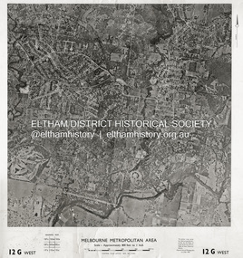
Photograph - Aerial Photograph, Central Plan Office, Eltham, Jan. 1960
... Historic Aerial Imagery Source: Central Plan Office Neg. No. 21451 (Print) Dept. of Lands & Survey and the Melb. & Metro. ...Central Plan Office...Historic Aerial Imagery Source: Central Plan Office Neg. No. 21451 (Print) Dept. of Lands & Survey and the Melb. & Metro. ...Centred on Bolton Street and Brougham Street, Eltham bounded by Progress Road to north, Yarra River to south, Andrews Street and Euclyptus Road to east and Greensborough Railway Station to west. Historic Aerial Imagery Source: Central Plan Office Neg. No. 21451 (Print) Dept. of Lands & Survey and the Melb. & Metro. Board of Works. Aerial Photo Details: MELBOURNE METROPOLITAN AREA Section : 12 G West Date : Jan./Feb. 1960 Scale : 800 feet to 1 inch 37°43'18.2"S 145°08'13.0"E Melways : 21 J6 (ed. 42)aerial photo, lower plenty, main road, montmorency, eltham, eltham lower park, heidelberg golf club, hurstbridge railway line, main road eltham, yarra river, 1960-01, andrews street, arthur street, bolton street, briar hill, brougham steet, dave lyon house, eltham north, eltham-yarra glen road, ernie andrew house, eucalyptus road, greensborough railway station, henry street, karingal road, melway 21j6, montmorency railway station, mount pleasant road, progress road, railway road, southernwood, were street -
 Emerald Museum & Nobelius Heritage Park
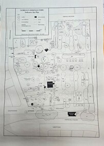
Map - Map of Nobelius Heritage Park - 2003, Nobelius Heritage Park, Indicative Site Plan - drawn November 2003, c2003
... Nobelius Heritage Park, Indicative Site Plan - drawn November 2003...Image of Indicative Site Plan of Nobelius Heritage Park...Nobelius Heritage Park, indicative site plan (Legend)/locations of tress/plants on the site...Emerald Museum & Nobelius Heritage Park 5 Crichton Rd Emerald yarra-valley-and-the-dandenong-ranges Laid out plan of Nobelius Heritage Park dated 2003, showing locations of trees and plants Nobelius Heritage Park, indicative site plan (Legend)/locations of tress/plants on the site Image of Indicative Site Plan of Nobelius Heritage Park Nobelius Heritage Park, Indicative Site Plan - drawn November 2003 Map Map of Nobelius Heritage Park - 2003 ...Laid out plan of Nobelius Heritage Park dated 2003, showing locations of trees and plantsImage of Indicative Site Plan of Nobelius Heritage ParkLaid out plan of Nobelius Heritage Park dated 2003, showing locations of trees and plants -
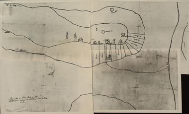
 University of Melbourne, Burnley Campus Archives
Photograph - Cul-de-sac planting design, Plan of Burnley Gardens, City of Richmond, Parish of Jika Jika, County of Bourke, 1948 (photograph)
... Plan of Burnley Gardens, City of Richmond, Parish of Jika Jika, County of Bourke...Reduced photograph of 1927 plans at B0489 A, B & C..."This plan is a copy of a copy of the survey made by Mr. ...Reduced photograph of 1927 plans at B0489 A, B & C Plan of Burnley Gardens, City of Richmond, Parish of Jika Jika, County of Bourke Photograph Cul-de-sac planting design ..."This plan is a copy of a copy of the survey made by Mr. Turner in 1926. The original plan and field notes are missing. See file Rs 3529" Signed by ? Andersonburnley gardens, victoria department of lands & survey, richmond, orchards, fowl yards -
Clunes Museum
Document, TALBOT - CLUNES SHIRE, MUNICIPAL EMERGENCY MANAGEMENT PLAN - SHIRE OF TALBOT AND CLUNES (DRAFT)
... MUNICIPAL EMERGENCY MANAGEMENT PLAN - SHIRE OF TALBOT AND CLUNES (DRAFT)...THIS PLAN (PERHAPS A DRAFT) WAS PREPARED AS A DISASTER , AND LATER EMERGENCY PLAN FOR THE SHIRE OF TALBOT / CLUNES IN THE EVENT OF A DISASTER, SUCH AS FIRE, FLOODS OR DESTRUCTION OF BUILDINGS...EMERGENCY MANAGEMENT PLAN - SHIRE OF TALBOT AND CLUNES....Clunes Museum 36 Fraser Street enter building through Collins Place Clunes goldfields THIS PLAN (PERHAPS A DRAFT) WAS PREPARED AS A DISASTER , AND LATER EMERGENCY PLAN FOR THE SHIRE OF TALBOT / CLUNES IN THE EVENT OF A DISASTER, SUCH AS FIRE, FLOODS OR DESTRUCTION OF BUILDINGS local history government local government council essential services THIS PLAN HAS BEEN PREPARED AT THE DIRECTION OF THE COUNCIL OF THE SHIRE OF TALBOT & CLUNES... ...THIS PLAN HAS BEEN PREPARED AT THE DIRECTION OF THE COUNCIL OF THE SHIRE OF TALBOT & CLUNES...DOCUMENTS COLLATED IN A GREEN PLASTIC BINDER WITH A CLEAR PLASTIC COVER (UNDATED)non-fictionTHIS PLAN HAS BEEN PREPARED AT THE DIRECTION OF THE COUNCIL OF THE SHIRE OF TALBOT & CLUNES...local history, government, local government, council, essential services -
 Federation University Historical Collection
Photograph - Black and White Photograph, Rough Plan of Golden Point in 1851
... Rough Plan of Golden Point in 1851...A photograph compilation of a Rough Plan of Golden Point in 1851. ..."Rough Plan of Golden Point in 1851. sketched from memory by Thos Dunn March 16th 1870." ...A photograph compilation of a Rough Plan of Golden Point in 1851. Rough Plan of Golden Point in 1851 Photograph Black and White Photograph ...A photograph compilation of a Rough Plan of Golden Point in 1851. "Rough Plan of Golden Point in 1851. sketched from memory by Thos Dunn March 16th 1870." golden point, ballarat, thomas dunn, cavanagh's claim, bickett's party, o'connor, hammond, greenwood, gold discovery -
![Planning Document, Plan of proposed subdivision of land in Greensborough [Map shows Scotland house], 01/04/1971](/media/collectors/4f729f5697f83e03086015b8/items/5982a68921ea6b1420e4e560/item-media/59916fb521ea681094908d7a/item-fit-380x285.jpg?cb=6) Greensborough Historical Society
Greensborough Historical SocietyPlanning Document, Plan of proposed subdivision of land in Greensborough [Map shows Scotland house], 01/04/1971
... Plan of proposed subdivision of land in Greensborough [Map shows Scotland house]...Photocopy of plan, 2 pages....Part of plan (68G) of proposed subdivision of Greensborough, part of Crown Portion 18, Parish pf Keelbundora. ...Scale: 132 ft. to an inch Photocopy of plan, 2 pages. Plan of proposed subdivision of land in Greensborough [Map shows Scotland house] Planning Document ...This subdivision of Greensborough shows the home of John Scotland (died 1888) and surrounding area bounded by Hailes, William, Lorimer, and Jessop Streets.Photocopy of plan, 2 pages.Part of plan (68G) of proposed subdivision of Greensborough, part of Crown Portion 18, Parish pf Keelbundora. Scale: 132 ft. to an inchjohn scotland, hailes street greensborough, william street greensborough, lorimer street greensborough, jessop street greensborough -
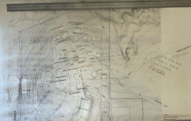 Creswick Campus Historical Collection - University of Melbourne
Map - Contour map of the School of Forestry Creswick, 1999, School of Forestry Creswick Existing Conditions Plan
... School of Forestry Creswick Existing Conditions Plan...Architectural paper plan of the School of Forestry...School of Forestry Creswick Existing Conditions Plan, Kevyn Joy Architects, Scale, 1:500, Jan 1999, Drawing No: 1035A...Creswick Campus Historical Collection - University of Melbourne 4 Water Street University of Melbourne Creswick Campus Building 719/718 Creswick goldfields School of Forestry Creswick Existing Conditions Plan, Kevyn Joy Architects, Scale, 1:500, Jan 1999, Drawing No: 1035A Architectural paper plan of the School of Forestry School of Forestry Creswick Existing Conditions Plan Map Contour map of the School of Forestry Creswick, 1999 ...Architectural paper plan of the School of ForestrySchool of Forestry Creswick Existing Conditions Plan, Kevyn Joy Architects, Scale, 1:500, Jan 1999, Drawing No: 1035A -
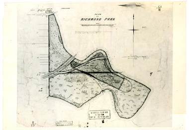 University of Melbourne, Burnley Campus Archives
Plan, Plan of Richmond Park, 1886-1948
... Plan of Richmond Park...Plan...(1) Black and white photographed copy of an original coloured plan. Plan of Richmond Park with Horticultural Society Gardens marked in. ...1 photocopy has "Figure 1. Plan of Burnley Gardens circa 1863 [sic]...Martin 1 photocopy has "Figure 1. Plan of Burnley Gardens circa 1863 [sic] (1) Black and white photographed copy of an original coloured plan. ...(1) Black and white photographed copy of an original coloured plan. Plan of Richmond Park with Horticultural Society Gardens marked in. Includes additional land which became the Field Station. Original plan dated 31 August 1872, note of Crown Grant to the Board of Land & Works and Richmond City Council 1886; showing land, "Permanently Preserved for the Gardens". Stamp, "Department of Lands and Survey Photographed at the Central Plan Office 1/1 Plate 7.12.48" (2) Also 2 photocopies, 1 reduced - possibly used in a publication1 photocopy has "Figure 1. Plan of Burnley Gardens circa 1863 [sic]gardens, richmond, horticultural society of victoria, richmond park, a.l. martin -
 Emerald Museum & Nobelius Heritage Park
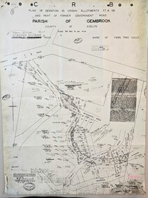
Map - Image of Plan of Deviation in Crown Allotments 57 & 58, Belgrave-Gembrook Rd., near Wright Rd. 1929, Plan of Deviation in Crown Allotments 57 & 58, Belgrave-Gembrook Rd., near Wright Rd. 1929, c1929
... Plan of Deviation in Crown Allotments 57 & 58, Belgrave-Gembrook Rd., near Wright Rd. 1929...Crown survey map showing plan of deviation in crown allotments 57 & 58, Belgrave-Gembrook Rd., near Wrights Rd., Parish of Gembrook.../Scale 100 foot to an inch/Certification of Plan (Signed) W.P. BONWICK, Surveyor Licensed under Act 2679/5-2-29/Survey Plan No. 2239.../Scale 100 foot to an inch/Certification of Plan (Signed) W.P. BONWICK, Surveyor Licensed under Act 2679/5-2-29/Survey Plan No. 2239 Crown survey map showing plan of deviation in crown allotments 57 & 58, Belgrave-Gembrook Rd., near Wrights Rd., Parish of Gembrook Plan of Deviation in Crown Allotments 57 & 58, Belgrave-Gembrook Rd., near Wright Rd. 1929 Map Image of Plan of Deviation in Crown Allotments 57 & 58, Belgrave-Gembrook Rd., near Wright Rd. 1929 ...Crown survey map showing plan of deviation in crown allotments 57 & 58, Belgrave-Gembrook Rd., near Wrights Rd., Parish of GembrookCRB/Plan of Deviation in Crown Allotments 57 & 58 and Part of Former Government Road/Parish of Gembrook, County of Evelyn/Belgrave-Gembrook Rd./Scale 100 foot to an inch/Certification of Plan (Signed) W.P. BONWICK, Surveyor Licensed under Act 2679/5-2-29/Survey Plan No. 2239 -
![Map, [Plan for road to give J. Allan access to permanent water at Coimadai] circa 1870s](/media/collectors/5e461d8021ea67224c82f2a1/items/67735190d671e67dd573a84c/item-media/6773533dd671e67dd573cd90/item-fit-380x285.jpg?cb=6) Bacchus Marsh & District Historical Society
Bacchus Marsh & District Historical SocietyMap, [Plan for road to give J. Allan access to permanent water at Coimadai] circa 1870s
... [Plan for road to give J. Allan access to permanent water at Coimadai] circa 1870s...The date of this map or plan is uncertain but it appears to be from the early to mid 1870s. ...Part of a set of maps which are pasted into a bound volume containing 76 maps or plans in total. High resolution digital image stored on BMDHS computer network. ...Plan showing Excisions from Ross's selection and 1 chain road thro' the said selection in Coimadai to give J. ...[Plan for road to give J. Allan access to permanent water at Coimadai] circa 1870s Map Shire of Bacchus Marsh ...The date of this map or plan is uncertain but it appears to be from the early to mid 1870s. One of the landholders identified on the plan, James Allan of Coimadai died suddenly on the 9th July, 1874 (see Bacchus Marsh Express, 11 July, 1874, page. 3). There are mentions of an Allans Road at Coimadai in the Bacchus Marsh Express between 1887 and 1942.Single page map showing an excision of land belonging to Charles Ross which was selected to construct a road to give another landholder, J. Allan access to permanent water. Scale 1 chain to 1 inch. Part of a set of maps which are pasted into a bound volume containing 76 maps or plans in total. High resolution digital image stored on BMDHS computer network. Plan showing Excisions from Ross's selection and 1 chain road thro' the said selection in Coimadai to give J. Allan access to permanent water. Alistair ?? Shire Eng? 6?/5/7?coimadai victoria maps, coimadai roads and streets -
 Greensborough Historical Society
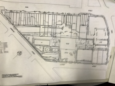
Planning Document, Banyule City Council, Site plan of Greensborough 1997, 28/07/1997
... Site plan of Greensborough 1997...Site plans for the area bounded by Flintoff Street; Grimshaw Street; Main Street and Para Road Greensborough. these plans show the area before the development of Watermarc....Set of 8 site plans...This plan shows central Greensborough before the Watermarc development greensborough greensborough swimming pool Set of 8 site plans Site plan of Greensborough 1997 Planning Document Banyule City Council ...Site plans for the area bounded by Flintoff Street; Grimshaw Street; Main Street and Para Road Greensborough. these plans show the area before the development of Watermarc.This plan shows central Greensborough before the Watermarc developmentSet of 8 site plansgreensborough, greensborough swimming pool -
 Ringwood and District Historical Society
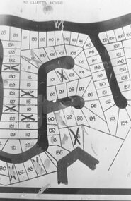
Photograph, Plan of Lots in Bel-Air Estate 1991
... Plan of Lots in Bel-Air Estate 1991...4 photographs of sections of the plans....Written on back of photograph, "20/6/81. Plan of Bel Air Estate. Werac Drive runs down left side of plan. ...Written on back of photograph, "20/6/81. Plan of Bel Air Estate. Werac Drive runs down left side of plan. ...4 photographs of sections of the plans.a. Written on back of photograph, "20/6/81. Plan of Bel Air Estate. Werac Drive runs down left side of plan. Kubis Drive crosses top. Debbie Place drops down from Kubis. Manuela Tce. runs right from Werac, ends at a bend and becomes Rudolf Court running North. Lyn Court takes off right from Rudolf and Burlock Ave. touches estate with an elbow" b. Written on back of photograph, "20/6/81. Plan of lots in Bel Air Estate. Glenvale Road down left side of plan, Kubis Dr. Runs across picture. June Square drops from and Jenken Close rises form Kubis Dr. Werac Dr. drops to bottom of picture and Manuella takes off to right". d. Written on back of photograph, "20/6/91. Lots in Bel-Air Estate. Kubis Dr. rises from bottom left to Oban Road top. Pamela Crt. drops from Kubis at left, Iluka Crt. takes off right. Whitlam Dr. runs left at top and Menzies Cr. drops off it to centre of picture". c. Written on back of photograph, "20/6/81. Plan of lots on Bel-Air Estate. Kubis Dr., Debbie Place, Pamela Crt, Iluka Crt. Menzies Drive" -
 Greensborough Historical Society
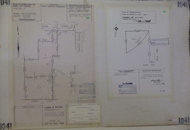
Planning Document, Subdivision Plan #1041. Elder Street Greensborough, 20/04/1983
... Subdivision Plan #1041. Elder Street Greensborough . ...Plan of Consolidation of Allotments 3 and 4 Brixton Avenue and Plan of Subdivision for Elder Street. ...Plan (2 sheets) mounted on heavy card....Plan (2 sheets) mounted on heavy card. Subdivision Plan #1041. ...Plan of Consolidation of Allotments 3 and 4 Brixton Avenue and Plan of Subdivision for Elder Street. An example of hard copy subdivision plans from the Greensborough area. Mainly from the Shire of Diamond Valley era (1964-1994).Plan (2 sheets) mounted on heavy card.Stamped and handwritten Council permissions, dates and other details.subdivision plans, elder street, brixton avenue -
 Emerald Museum & Nobelius Heritage Park
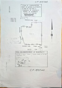
Map - Plan of Consolidation part of Crown Allotments 51 & 10B, Section A, Township of Emerald, Parish of Gembrook, County of Evelyn, Plan of consolidation for government allotment in Emerald, sealed on 19 November, 1984 (Property later to be known as Nobelius Heritage Park, Emerald), c1984
... Plan of consolidation for government allotment in Emerald, sealed on 19 November, 1984 (Property later to be known as Nobelius Heritage Park, Emerald)...Image of Plan of Consolidation of Crown Allotments in township of Emerald...CP159745, Plan of Consolidation Part of Crown Allotments 51 & 10B Section A, Township of Emerald, Parish of Gembrook, County of Evelyn, area bounded by Emerald Lake Rd., Princess Avenue, Crichton Rd., Kings Avenue. ...Seal and endorsement of municipality - this plan is sealed puRsuant to Section 569AB of the Local Government Act, dated 19th November, 1984, (Property later to be known as Nobelius Heritage Park, Emerald) Image of Plan of Consolidation of Crown Allotments in township of Emerald Plan of consolidation for government allotment in Emerald, sealed on 19 November, 1984 (Property later to be known as Nobelius Heritage Park, Emerald) Map Plan of Consolidation part of Crown Allotments 51 & 10B, Section A, Township of Emerald, Parish of Gembrook, County of Evelyn ...Image of Plan of Consolidation of Crown Allotments in township of Emeraldnon-fiction -
 Greensborough Historical Society
Planning document, City of Heidelberg, Subdivision Plan # G26. Grace Park Estate Greensborough, 1950c
... Subdivision Plan # G26. Grace Park Estate Greensborough....Plan of Subdivision (G26). Grace Park Estate. ...Plan mounted on heavy card....Plan mounted on heavy card. Subdivision Plan # G26. ...Plan of Subdivision (G26). Grace Park Estate. An example of hard copy subdivision plans from the Greensborough area. From Shire of Heidelberg.Plan mounted on heavy card.Stamped and handwritten Council permissions, dates and other details.subdivision plans, grace park -
 Bacchus Marsh & District Historical Society
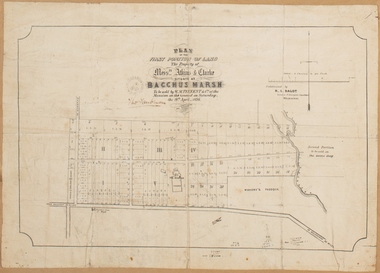
Map, Plan of the property of Messers Atkins and Clarke to be sold at the Mansion, Bacchus Marsh 19th April 1856. Copy 1
... Plan of the property of Messers Atkins and Clarke to be sold at the Mansion, Bacchus Marsh 19th April 1856. ...This plan, VC Record 707 Copy 1, contains a little more detail overall than VC Record 452 Copy 2, such as who did the survey work for the plan (R.C. ...Scale: 8 chains to 1 inch The plan is pasted into a bound volume containing 76 maps or plans in total. ...Heading: Plan of the first portion of land. The property of Messers Atkins and Clarke situate at Bacchus Marsh. ...Scale: 8 chains to 1 inch The plan is pasted into a bound volume containing 76 maps or plans in total. ...This plan of land allotments for sale indicates the property once owned by the Bacchus family in and around the township area of Bacchus Marsh. The Bacchus family sold their property in Bacchus Marsh to John Atkins and Robert Nalder Clarke in March 1851. Atkins and Clarke kept the property for a number of years until April 1856 when these allotments were put up for sale.This plan is almost identical to another copy held by the Bacchus Marsh and District Historical Society, VC Record 452, BMDHS collection). This plan, VC Record 707 Copy 1, contains a little more detail overall than VC Record 452 Copy 2, such as who did the survey work for the plan (R.C. Bagot) and who the selling agents were, (W.M. Tennent), and on the right side of the plan near the Lerderderg River is indicated the general area for a second parcel of land from this sale which is to be sold. There is also a compass illustration indicating north and south compass points.This is a very early land sales plan for the township of Bacchus Marsh and it therefore provides some clues as to how the early urban development of the township took place. Upon seeing the map in 1911 Bacchus Marsh Express newspaper editor Christopher Crisp wrote "The sale appears to have created the present township, which had a nucleus in earlier times further east", Express, 30 September, 1911, page 3.A single page paper plan showing allotments of land for sale. The subdivided land shown was owned by John Atkins and Robert Nalder Clarke, but previously owned by the Bacchus Family and was in and around their Manor House (Mansion) property in Bacchus Marsh.There are 5 portions of land further divided into numerous small portions. The land for sale is bounded by the present day streets of Main Street, Young Street, McFarland Street, Morton Streets, Crook Street, and part of the eastern section extends to the Lerderderg River. Scale: 8 chains to 1 inch The plan is pasted into a bound volume containing 76 maps or plans in total. BMDHS Loc: AR/B12/S4 Bacchus Marsh Township and Nearby Districts Maps Volume In-house Digital copies: BMDHS, Computer Network: Maps\Bacchus Marsh Township and Nearby Districts Maps VolumeHeading: Plan of the first portion of land. The property of Messers Atkins and Clarke situate at Bacchus Marsh. To be sold by W.M. Tennent & Co. at the Mansion on the Ground on Saturday the 19th April 1856. Below heading: Jas Ferguson, Lithographer On upper right side: Subdivided by R.C. Bagot London and Liverpool Chambers, Melbourne. 'Thos Taubman'. Post Office Stamp: BACCHUS MARSH VICTORIA MY 6, 63bacchus marsh victoria maps, bacchus family, land sales, manor house bacchus marsh