Showing 46 items matching "alpine national park"
-
 Kiewa Valley Historical Society
Papers - Alpine Nature Rambles x2
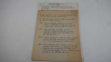
... ...alpine national park'...18 pages stapled in top left hand corner of handwritten (in black) notes on the program for a guided tour from Tawonga,to the SEC 'office', Mt Beauty, Clover Power Station, Bogong Village, Falls Creek, High Plains 'Alpine' National Park and Mt Beauty....It includes historical facts. kiewa valley tourism mt beauty secv alpine national park' tawonga falls creek Pink texta on first page: 'Jill' 18 pages stapled in top left hand corner of handwritten (in black) notes on the program for a guided tour from Tawonga,to the SEC 'office', Mt Beauty, Clover Power Station, Bogong Village, Falls Creek, High Plains 'Alpine' National Park and Mt Beauty. ...Written early 1990s for a bus tourist group. It includes historical facts. 18 pages stapled in top left hand corner of handwritten (in black) notes on the program for a guided tour from Tawonga,to the SEC 'office', Mt Beauty, Clover Power Station, Bogong Village, Falls Creek, High Plains 'Alpine' National Park and Mt Beauty.Pink texta on first page: 'Jill'kiewa valley tourism, mt beauty, secv, alpine national park', tawonga, falls creek -
 Kiewa Valley Historical Society
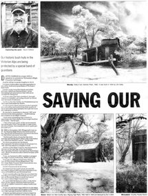
Newspaper article- Double page article. Pages 30 & 83 from the Herald Sun Newspaper. February 18, 2006 regarding preserving Victoria’s High Country Huts
... Cattlemen's Huts; David Oldfield; Bogong High Plains; Wallace's Hut; High Country; Alpine National Park...Wallace’s Hut is the oldest of the Cattleman’s huts still standing in the Alpine National Park and is classified under the National Trust. ...Wallace’s Hut is the oldest of the Cattleman’s huts still standing in the Alpine National Park and is classified under the National Trust. ...The arrival of explorers Hume & Hovell in 1842 brought about the widespread clearing of land in the valleys for pastoral uses and the displacement the original inhabitants in the high country which became a boon for cattlemen due to extensive lush summer grazing for cattle. High country cattlemen built a variety of huts for shelter and storage, when driving cattle up to the plains in summer, during mustering and bringing the cattle down from the mountains before winter closed in. These same huts now provide shelter from the elements for hikers, bush walkers and skiers. Wallace’s Hut is the oldest of the Cattleman’s huts still standing in the Alpine National Park and is classified under the National Trust. Due to their age and the ravages of the elements, including bush fires, many of the huts have been destroyed, or are falling into disrepair. Groups of willing volunteers are now working to preserve as many of the huts as possible with restoration or rebuilding.The numerous cattleman’s huts of the Alpine National Park and the colourful characters who erected them represent a significant part of the history of the high country area and early cattle grazing, which has been the theme for many poets and film-makers alike. They also have a significant role in the early days of the SECV when they were used by surveyors and other workers for shelter and temporary accommodation. More recently the huts have functioned as shelter for hikers and skiers caught out in the elements and a refuge along the long trek for bush walkers. They are a popular attraction for tourists and feature prominently in much of the tourist information of the region. Black and white double page Newspaper article from the Herald Sun Newspaper of February 18, 2006 regarding the efforts of Mr David Oldfield to preserve Victoria’s remaining High Country Huts through his photography and efforts to restore old and Re-build missing ones. Article shows a photograph of David Oldfield and some of his photographic work of the huts. Page number and date printed at top of each page 30 Herald Sun, Saturday, February 18, 2006 Herald Sun, Saturday, February 18, 2006 83 cattlemen's huts; david oldfield; bogong high plains; wallace's hut; high country; alpine national park -
 Kiewa Valley Historical Society
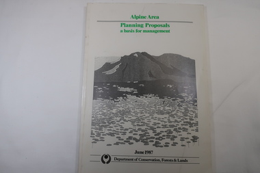
Book - Book - Alpine Area - Department of Conservation, Forests & Lands, Alpine Area / Planning Proposals / a basis for management. 1987
... Alpine Area...Bogong National Park...It is the policy of the Government that most of the State's alpine area will be proclaimed as an Alpine National Park, which would complement the Kosciusko National Park in N.S.W.. ...Kiewa Valley Historical Society Mount Beauty Information Centre 31 Bogong High Plains Rd Mt Beauty high-country It is the policy of the Government that most of the State's alpine area will be proclaimed as an Alpine National Park, which would complement the Kosciusko National Park in N.S.W.. ...It is the policy of the Government that most of the State's alpine area will be proclaimed as an Alpine National Park, which would complement the Kosciusko National Park in N.S.W.. This is yet to be achieved (1987), however there is a need for sound, efficient and coordinated management based on the area's natural features, values and uses. Planning is proceeding on this basis.Victoria's alpine area is one of the State's most outstanding and spectacular natural areas. It is noted for its diverse plant and animal life, scenery, recreation opportunities and as a water catchment. This country is at the upper end of the Kiewa Valley and the planning for it is of interest to the Kiewa Valley inhabitants.White bound book with green print for title at the top, black & white picture and black print at the bottom for the name of the government authority publishing the book.143 pages with fold out map after page 7. The map is coloured green to indicate the planning area.alpine area, bogong national park, victorian department of conservation forests & lands -
 Lakes Entrance Historical Society
Book, Johnson, Dick, The Alps at the Crossroads, 1974
... Contains historical evidence of the use and misuse of the Alpine area and the need for management of this special environment by the establishment of an Alpine National Park. Many illustrations and maps....Lakes Entrance Historical Society 4 Marine Parade Lakes Entrance gippsland Environment Settlement Contains historical evidence of the use and misuse of the Alpine area and the need for management of this special environment by the establishment of an Alpine National Park. Many illustrations and maps. ...Contains historical evidence of the use and misuse of the Alpine area and the need for management of this special environment by the establishment of an Alpine National Park. Many illustrations and maps.environment, settlement -
 Victorian Aboriginal Corporation for Languages
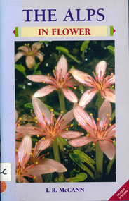
Book, I R McCann, The Alps in flower, 2001
... ...Alpine National Park...Victorian Aboriginal Corporation for Languages 33 Saxon Street Brunswick melbourne Alps Victorian National Parks Association Bogong Unit Alpine National Park Mount Buffalo National Park Wonnangatta-Moroka Unit Kosciusko National Park Maps, colour photographs Format using photographs and a brief description of each plant. ...Format using photographs and a brief description of each plant.Maps, colour photographsalps, victorian national parks association, bogong unit, alpine national park, mount buffalo national park, wonnangatta-moroka unit, kosciusko national park -
 Kiewa Valley Historical Society
Map - Cattlemen from Kiewa Valley
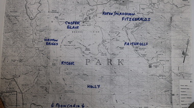
... Photocopied topographical map of part of the Alpine National Park showing 11 families areas for cattle grazing. ...Photocopied topographical map of part of the Alpine National Park showing 11 families areas for cattle grazing. ...Cattle grazing on the Bogong High Plains occurred on most summers since the 1840s. The families were farmers from the Kiewa Valley. The 2003 fires interrupted this tradition which was discontinued altogether in 2005 for environmental reasons. This tradition is still controversial.History of Cattle grazing on the Bogong High Plains and farming in the Kiewa Valley and the families that lived there.Photocopied topographical map of part of the Alpine National Park showing 11 families areas for cattle grazing. Dated 1991/92 up to 2003 fires.91/92 Until fires in 2003 Families names have been added in blue texta. They are: 'Kelly, Faithful, Weston Briggs, Ryder, Cooper, Blair, Roper, Maddison, Fitzgeralds, Hicks.'cattlemen of the kiewa valley, cattle grazing on the bogong high plains -
Lakes Entrance Historical Society
Map - Grant Historic Adventurer, Paolett Adventure Maps, March 1998
... McMillans walking track, picnic areas, camping areas, Alpine National Park 1 page Included with map is a flyer for township of Grant compiled by Friends of Grant 10517A...McMillans walking track, picnic areas, camping areas, Alpine National Park 1 page Included with map is a flyer for township of Grant compiled by Friends of Grant 10517A Map Grant Historic Adventurer Paolett Adventure Maps ...Shows sealed and unsealed roads, rivers or creeks. McMillans walking track, picnic areas, camping areas, Alpine National Park 1 page Included with map is a flyer for township of Grant compiled by Friends of Grant 10517Aforest, recreation, townships, roads and streets, parks -
 Orbost & District Historical Society
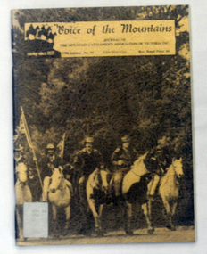
journal, E-Gee Printers, Voice of the Mountains, 1986
... It has a brown cover with a photograph , "On the Road to Ringwood - protest ride against the establishment of Alpine national Park". It is titled :"Voice of the Mountains, Journal of the Mountain District Cattlemen's Association of Victoria Inc., 1986 Edition no 10" and is priced at $4.00. ...It has a brown cover with a photograph , "On the Road to Ringwood - protest ride against the establishment of Alpine national Park". It is titled :"Voice of the Mountains, Journal of the Mountain District Cattlemen's Association of Victoria Inc., 1986 Edition no 10" and is priced at $4.00. ..."The Association was officially launched in November 1967 with the aim of preserving and maintaining good relations and understanding within the cattle industry and between that industry and all bodies and organisations with which the industry is associated in the spheres of Government, and land use and marketing." (ref Mountain Cattlemen's Association web-site) Since 1972, the Mountain Cattlemen’s Association of Victoria, have produced a journal, “The Voice of the Mountains”. This journal commemorates the activities and history of the previous twelve months and bygone years of cattlemen and their families. This item was used in the library of Orbost Secondary College. The journals form a part of Victoria’s history and are a useful research tool.A 44 pp book covered in clear contact. It has a brown cover with a photograph , "On the Road to Ringwood - protest ride against the establishment of Alpine national Park". It is titled :"Voice of the Mountains, Journal of the Mountain District Cattlemen's Association of Victoria Inc., 1986 Edition no 10" and is priced at $4.00. journal-voice-of-the-mountains cattlemen-history cattle-industry -
 Kiewa Valley Historical Society
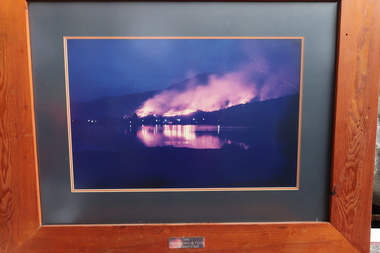
Photos: 2003 Fires at Bogong and Scientific Research at Bogong
... The 2003 bushfires caused by a lightning strikes on 8th January 2003. 87 fires were ignited 8 of which would join to form the largest fire in Victoria since the 1939 Black Friday bushfires, burning through 60% of the Alpine National Park. Ref. The Mountain Journal. Scientific research was used to test new methods during construction....Kiewa Valley Historical Society Mount Beauty Information Centre 31 Bogong High Plains Rd Mt Beauty high-country The 2003 bushfires caused by a lightning strikes on 8th January 2003. 87 fires were ignited 8 of which would join to form the largest fire in Victoria since the 1939 Black Friday bushfires, burning through 60% of the Alpine National Park. Ref. The Mountain Journal. Scientific research was used to test new methods during construction. ...The 2003 bushfires caused by a lightning strikes on 8th January 2003. 87 fires were ignited 8 of which would join to form the largest fire in Victoria since the 1939 Black Friday bushfires, burning through 60% of the Alpine National Park. Ref. The Mountain Journal. Scientific research was used to test new methods during construction.These fires were close to Bogong village and Mt Beauty. The photos were displayed in the Mountain Monk Hotel, Mt Beauty which was the original SEC Working Mens Club during the construction of the Kiewa Hydro Electric Scheme. Scientific research was used to create new improved methods during construction. Framed photos (1-3) of the 2003 bushfires at Bogong village and Photos (4-11) with titles involving scientific work by the SECV. 1-3 2003 Bogong Complex Fires at Moncrieffs Gap 4. Phasmid Eggs 5. Insect cages 6. Spraying Bitumen 7. Grass grown after spray 8. "Finn" method 9. Erosion raceline bank 10. "Finn" treatment 11. Machine spraying grass seed2003 bushfires, moncrieffs gap -
 Kiewa Valley Historical Society
Newspapers - Cattlemen
... From 1978, the Alpine National Park management, along with the Victorian Government stopped the practice as a result of studies showing the deterioration of the land due to the cattle grazing on the High Plains.This disagreement resulted in the banning of cattle on the High Plains....From 1978, the Alpine National Park management, along with the Victorian Government stopped the practice as a result of studies showing the deterioration of the land due to the cattle grazing on the High Plains.This disagreement resulted in the banning of cattle on the High Plains. ...Traditionally, farmers from the Kiewa Valley took their cattle up to the Bogong High Plains during the summer for better feed. From 1978, the Alpine National Park management, along with the Victorian Government stopped the practice as a result of studies showing the deterioration of the land due to the cattle grazing on the High Plains.This disagreement resulted in the banning of cattle on the High Plains.A collection of newspaper reports on the issue of cattle grazing on the Bogong High Plains. Also, the Conservation Council's argument for the cattle being excluded from the Bogong High Plains. Newspaper cuttings re Cattlemen in the High Plains from 1978. Book - Land Conservation 1983 - pale blue 81 pages.cattlemen on the high plains, bogong high plains, land conservation council -
 Kiewa Valley Historical Society
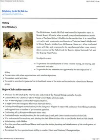
Printed material from the internet, with colour illustrations – History of the Birkebeiner Nordic Ski Club Inc, 14/01/2016
... The club, located in Mount Beauty has conducted many activities and programs for its members and other cross country skiers at the Falls Creek Ski Resort, Alpine National Park and the Bogong High Plains. Club objectives are to promote the development of cross country racing, ski touring and associated activities. ...The club, located in Mount Beauty has conducted many activities and programs for its members and other cross country skiers at the Falls Creek Ski Resort, Alpine National Park and the Bogong High Plains. Club objectives are to promote the development of cross country racing, ski touring and associated activities. ...The Birkebeiner Nordic Ski Club was formed in September 1977 when a group of enthusiasts met to discuss the idea. The club, located in Mount Beauty has conducted many activities and programs for its members and other cross country skiers at the Falls Creek Ski Resort, Alpine National Park and the Bogong High Plains. Club objectives are to promote the development of cross country racing, ski touring and associated activities. To assist in searches for persons lost in bushland areas and to maintain a Search and Rescue group. It also provides its members with opportunities for skiing and social activities. The Birkebeiner Nordic Ski Club constructed a clubhouse at Falls Creek for the use of members in 1996. The club has conducted the annual Kangaroo Hoppet since 1991. Since its inception, the Birkebeiner Nordic Ski Club has been active in promoting cross country skiing including racing and touring in the Falls Creek, Alpine National Park and the Bogong High Plains areas and have actively participated in search and rescue in the alpine region. Birkebeiner members have represented Australia at five Olympic Games. A number of Kiewa Valley residents are active members or have been past members of the club over the years.Printed material from the internet with colour illustrations – History of the Birkebeiner Nordic Ski Club Inc. Sourced from http://birkebeiner.org.au/about/history/, 14/01/2016 7.45pmbirkebeiner ski club; nordic skiing; cross country skiing; falls creek; bogong high plains -
 Kiewa Valley Historical Society
Collection - Ian Roper
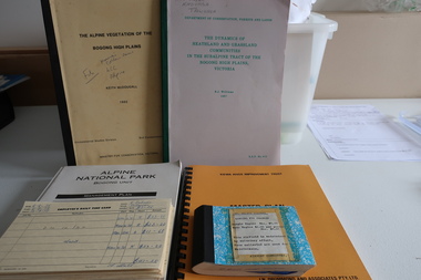
... National Park 1983. 4. The Dynamics of Heathland and Grassland Communities in the Subalpine Tract - Bogong High Plains 1987. 5. Alpine...The Dynamics of Heathland and Grassland Communities in the Subalpine Tract - Bogong High Plains 1987. 5. Alpine National Park Bogong Unit -Management Plan 1992.6. ...Various reports and studies ordered by the Victorian Government and the Alpine shire.History of the Kiewa Valley and North East Victoria including the airport at Mount BeautyA collection of publications and Items significant to the Kiewa Valley Including Kiewa Valley and Surrounds, the Kiewa River, and Pygmy Possums. Also items and reports relating to the North East of Victoria. 1. Kiewa River Improvement Trust- Master Plan 1984. 2. Guidelines Conservation Mountain Pygmy Possum -Management Strategy 1989. 3. Proposed Interim Management Plan -Bogong National Park 1983. 4. The Dynamics of Heathland and Grassland Communities in the Subalpine Tract - Bogong High Plains 1987. 5. Alpine National Park Bogong Unit -Management Plan 1992.6. Alpine Vegetation of the Bogong High Plains - Bogong High Plains 1982. 7. Early 1970s onwards, records of banking, receipts, landing fees, letters, photos, key, minutes, visitor book, record of landings (book), postcards, SEC Victoria's Kiewa Valley Brochure - Mt Beauty Airport History 1`977+ian roper, mount beauty airport, pygmy possums, vegetation -
 Falls Creek Historical Society
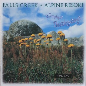
Booklet - Falls Creek Alpine Resort Summer Breakaways 1996/1997
... General activities explained in he brochure are:- Enjoying A Bushwalk In The Alpine National Park, Water Sports, Horse Riding, Mountain Bike Riding, Two & Four Wheel Driving, High Country Wining & Dining, Discovering The Wildlife. ...General activities explained in he brochure are:- Enjoying A Bushwalk In The Alpine National Park, Water Sports, Horse Riding, Mountain Bike Riding, Two & Four Wheel Driving, High Country Wining & Dining, Discovering The Wildlife. ...Part of a yearly marketing and information program to promote Falls Creek region for the summer season. . General activities explained in he brochure are:- Enjoying A Bushwalk In The Alpine National Park, Water Sports, Horse Riding, Mountain Bike Riding, Two & Four Wheel Driving, High Country Wining & Dining, Discovering The Wildlife. Daybreaks & Golden Sunsets And Pure Relaxation. The specific activities in the Summer Program of Events include:- Alpine Nature Rambles. Angling Expeditions, Christmas Carols, National Distance Camp, Food, Wine & Wildflower Weekend, High-O Orienteering Event, Mile High Tennis Tournament, High Country Mountain Bike Ride, Classical Music Weekend, Cadbury Red Tulip Giant Easter Egg Hunt And Festivities. The “Breakaways” brochure is a publication of the Falls Creek Chamber of Commerce, an organisation dedicated to establishing Falls Creek as the premier alpine resort In Australia. This item is important as it documents seasonal activities at Falls Creek Alpine ResortA brochure for summer program at Falls Creek for 1996/7. The front cover features an image of yellow wildflowers, mountain rocks and the sky with the title"Falls Creek Alpine Resort Summer Breakawaysfalls creek marketing, falls creek summer programs., falls creek alpine resort, falls creek events and activities -
 Falls Creek Historical Society
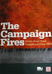
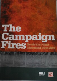
Book - The Campaign Fires - North-East/East Gippsland Fires 2003, Lyndel Hunter
... Alpine bushfires started on 8th January 2003, a day of Total Fire Ban. Lightning ignited 87 fires in the North-East and East Gippsland regions. Eight of these fires were unable to be contained; they joined together to form the largest fire in Victoria since the Black Friday fires in 1939. The majority of the area burnt in Victoria was public land, 1.19 million hectares of parks and forests, including 60 per cent of the Alpine National...Alpine bushfires started on 8th January 2003, a day of Total Fire Ban. Lightning ignited 87 fires in the North-East and East Gippsland regions. Eight of these fires were unable to be contained; they joined together to form the largest fire in Victoria since the Black Friday fires in 1939. The majority of the area burnt in Victoria was public land, 1.19 million hectares of parks and forests, including 60 per cent of the Alpine National ...A description of efforts to fight the bushfires in Gippsland in 2003, including maps and illustrations. This volume was published as a tribute to the work of staff and volunteers who put themselves at risk to protect local communities. It shows the impact on those communities in Victoria and the support they gave to those involved in fighting largest bushfires in Victoria for 60 years. The Alpine bushfires started on 8th January 2003, a day of Total Fire Ban. Lightning ignited 87 fires in the North-East and East Gippsland regions. Eight of these fires were unable to be contained; they joined together to form the largest fire in Victoria since the Black Friday fires in 1939. The majority of the area burnt in Victoria was public land, 1.19 million hectares of parks and forests, including 60 per cent of the Alpine National Park and 81 per cent of the Mt Buffalo National Park. Firefighting efforts were made difficult in hard-to-access, remote forest terrain. Approximately 90,000 hectares of private land was burnt.This book is significant because it documents the 2003 Victorian Bushfires and serves as a tribute to the CFA staff and volunteers who fought them.This publication of 119 pages features text, colour images, maps and detailed information related to the 2003 bushfires in Victoria.At bottom of front cover:- CFA Victoria Logo Victorian Government Logovictorian fires 2003, cfa (vic) -
 Kiewa Valley Historical Society
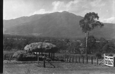
Photograph - Mt Bogong - Tawonga, 06/05/1937
... Mount Bogong located in the Alpine National Park and part of the Victorian Alps of the Great Dividing Range, is the highest mountain in Victoria, Australia, at 1,986 metres (6,516 ft) above sea level. ...Kiewa Valley Historical Society Mount Beauty Information Centre 31 Bogong High Plains Rd Mt Beauty high-country Mount Bogong located in the Alpine National Park and part of the Victorian Alps of the Great Dividing Range, is the highest mountain in Victoria, Australia, at 1,986 metres (6,516 ft) above sea level. ...Mount Bogong located in the Alpine National Park and part of the Victorian Alps of the Great Dividing Range, is the highest mountain in Victoria, Australia, at 1,986 metres (6,516 ft) above sea level. The Big River separates the massif of the mountain from the Bogong High Plains to the south. From the nearby town of Mount Beauty to its summit, Mount Bogong rises more than 1,600 metres (5,200 ft), thus making it one of the highest peaks in Australia not only in terms of its elevation above sea level, but also in terms of actual base-to-summit prominence. Mount Bogong is a popular backcountry skiing mountain through winter but only has snow for the mid winter-spring months. It is around 30 kilometres (19 mi) by road and walking track or 12 kilometres (7.5 mi) direct to Mount Beauty. Falls Creek and Mount Hotham ski resorts are also nearby. Camping is relatively safe below the tree line but the summit ridgeline is very exposed. Emergency shelter is also available at Bivouac Hut on the Staircase Spur, and at Cleve Cole, above Camp Creek on the broad ridge to the south of the summit, and Michells Hut on the Eskdale Spur. Mt Bogong is a popular recreational venue in the Kiewa Valley for back country skiing and bush walking and is a favourite with sightseers and popular subject for photographersBlack and white photograph of Mt bogong taken from Tawonga - Thursday May 6th, 1937Handwritten on back of photograph. Thursday May 6th, 1937. Mt Bogong Tawongamt bogong, tawonga, kiewa valley -
 Falls Creek Historical Society
Clothing - Shirt Falls Creek Mountain Bike Park Crew
... The Falls Creek Mountain Bike Park opened in 2013 with 40 kilometres of trails in the Victorian Alpine National Park. Designed and built by World Trail, the bike trails provide access to beautiful alpine terrain. ...The Falls Creek Mountain Bike Park opened in 2013 with 40 kilometres of trails in the Victorian Alpine National Park. Designed and built by World Trail, the bike trails provide access to beautiful alpine terrain. ...The Falls Creek Mountain Bike Park opened in 2013 with 40 kilometres of trails in the Victorian Alpine National Park. Designed and built by World Trail, the bike trails provide access to beautiful alpine terrain. The rides now extend over more than 50 kilometres, catering for a range of abilities and providing activities in the summer season. All trails start and finish in the resort. The high-altitude trails of Falls Creek include a range of wide gravel roads to winding single trails. The graded trails include rides to the Rocky Valley Lake, historic cattlemen’s huts such as Cope Hut and Wallaces Hut, the top of Mt McKay, Pretty Valley Lake and for the experts the ride to Mt Nelse and the Spion Kopje summit. MTB Bike Patrol Top To ensure rider safety, Falls Creek Resort introduced a Bike Patrol service during shuttle operating hours. Many Ski Patrol members transitioned into these roles, offering riders peace of mind that medical care was available quickly if needed. The program highlighted the resort's commitment to duty of care and to growing mountain biking responsibly. This shirt was designed by Australian Company Dharco as a highly visible uniform for crew at the Falls Creek Mountain Bike Park. Jo Prothero, Director of Marketing for Falls Creek Resort Management from 2012 to 2019, generously donated two mountain bike jerseys that capture a pivotal era in the resort's history. During Jo's tenure, the resort made significant investments in mountain bike trails, aiming to activate the village during the summer months and support local businesses. This development included appointing Blue Dirt as the resort's first shuttle operator, transporting riders from Howman's Gap to the Summit.This shirt is significant as it is representative of the Falls Creek Mountain Bike Park development.A uni-sex style shirt designed to be worn by mountain bike crews in Falls Creek, Victoria. It has multi-coloured panels of black, orange, yellow and grey. It features an image of a mountain biker descending a slope on the front along with the manufacturer's name. Sponsors' logos also feature across the lower backOn front: PARK CREW/ DHARCO On back: Falls Creek Mountain Bike Park On both sleeves: PARK CREWfalls creek mountain bike park, falls creek staff uniform -
 Kiewa Valley Historical Society
Maps - Bogong x2, Tawonga, Omeo, Dargo, Victoria and others, 1. Bogong Alpine Area; 2. Bogong 8324; 3. Tawonga Topographical; 4. Omeo 8433; 5. Dargo 8323; 6. Victoria State
... Information for tourist in the Alpine National Park: Bogong Area. Including: recreational activities, history, weather and vegetation and a list of walks together with locality maps and photographs. ...Information for tourist in the Alpine National Park: Bogong Area. Including: recreational activities, history, weather and vegetation and a list of walks together with locality maps and photographs. ...1. Bogong Alpine Area (outdoor Leisure Map. survey & Mapping Victoria, Government of Victoria, Edition 2, reprinted 1991 with an image of Mt. Feathertop on the front. Information for tourist in the Alpine National Park: Bogong Area. Including: recreational activities, history, weather and vegetation and a list of walks together with locality maps and photographs. The front cover has an image of Mt Feathertop against a blue sky with yellow writing 'Bogong Alpine Area', there is a yellow triangular block on the right hand top corner with black writing 'Outdoor Leisure Map. On the bottom edge is a block of yellow with black writing 'Survey & Mapping Victoria' and a light green map of Victoria with 'VICMSP' printed in white. 2. 8324 Bogong Victoria, Edition 1, Commonwealth of Australia 1981. A topographical Map: 1:100,000 scale (1 cm to 1 KM). Map has a red cover with white writing together with a white block and black writing and a map insert. 3. Tawonga Topographical Map - Forests Commission Victoria, / revised 5/9/77, DEG No. 68-G/399. A Tawonga 803 folded map in a beige colour with the back blank. 4. Omeo 8433 Victoria, Edition 1, Department of Natural Resources. The map has a red and white cover with black writing and a simple map of Australia at the bottom. 5. 8323 Dargo, Edition 1, Commonwealth of Australia. A red and white cover with a map insert. 6. Victoria State Map, Hema Maps, 2002. Hema Maps, State Map, colourful cover with a map of Australia and four tourism photographs. Scale 1: 850,000 An inscription handwritten in blue pen "Trappers Gap to Mitta Mitta 1" to 1 mile". There are some pen markings and notations of tracks.maps, bogong, omeo, tawonga, dargo, victoria, bogong alpine area -
 Kiewa Valley Historical Society
Folder - Cattle Grazing, Cattle Grazing in the Alpine Study Area
... national parks J. Commins on cover page at the top. Cover includes the heading 'National Parks Service' and is bound on the spine with black tape. This is followed by 'File Title' on yellow cardboard marked with column and lines. Inside: 35 pages printed on one side. Pages are bound by steel binder. Dated: June 1978 Cattle Grazing in the Alpine ...Cattlemen / Beef Farmers of the Kiewa Valley took their cattle up to the High Plains to graze during summer.Cover includes the heading 'National Parks Service' and is bound on the spine with black tape. This is followed by 'File Title' on yellow cardboard marked with column and lines. Inside: 35 pages printed on one side. Pages are bound by steel binder. Dated: June 1978J. Commins on cover page at the top.bogong high plains, cattle grazing, farmers of the kiewa valey, national parks -
 Kiewa Valley Historical Society
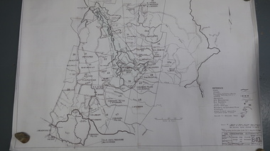
Map - Bogong High Plains - Grazing Runs, Grazing Run Boundaries 1960 - Soil Conservation Authority
... Cattle have been banned in the Alpine National Park due to their impact on the environment. cattlemen grazing runs bogong high plains kiewa valley families White paper with brown print. ...Cattle grazing on the Bogong High Plains during summer commenced in the 1840s and continued for many years. The Soil Conservation Authority recorded each family's area boundaries which were updated in June 1972 and continued to be adjusted until cattle were banned in 2005. The tradition of cattle grazing continues to be controversial.Holders of grazing rights for grazing on the Bogong High Plains were allocated specific areas recorded by the Soil Conservation Authority in 1972. Cattle have been banned in the Alpine National Park due to their impact on the environment.White paper with brown print. Bogong High Plains from Feathertop in the west to Mt Nelse in the east showing physical boundaries including the Kiewa Hydro Electric Scheme, roads, rivers and mountains. Names of families with grazing runs and the boundaries are shown.cattlemen, grazing runs, bogong high plains, kiewa valley families -
 Kiewa Valley Historical Society
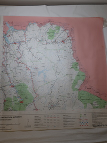
Map - Road Construction Authority 1986, Ref. Tallangatta 282008
... Pre dates the Alpine National Park. 2. 'Mt Beauty Estates' now known as Tawonga South. 3. ...Government authorities updated maps regularly.Historically of interest eg. 1. Pre dates the Alpine National Park. 2. 'Mt Beauty Estates' now known as Tawonga South. 3. Mt Niggerhead is named - It is now known as Mt Jaithmathang having been renamed in 2009.Colored map dated 1986 titled Road Construction Authority with an update of roads in the local Shires. It names places in the area and has a legion describing the rating of the roads and tracks. It also shows the main towns in the area and their roads.road construction authority, map of tallangatta area -
Marysville & District Historical Society
THE TRIANGLE NEWS-VOL 39 NO 26-JULY 13 2012
... park precinct...marysville community market...creative triangle...murrindindi shire council...shire tennis club growth support...alexandra junior soccer club...advertisements...vale stephen franzi-ford...church notices...parkinsons victoria ambassadors of hope...marysville golf report...goulburn river high country rail trail...rising power and gas bills...marysville pharmacy...marysville medical clinic...mayor's chair...adventurous cooks...marysville community golf & bowls club...trivia and pasta...intrepid triangle bushwalkers...sample wines...alexandra library...midnight express dance...taggerty hall...alexandra cinema...real estate...council's rating review strategy...yea council chambers...lake mountain alpine resort...ann thoma 1995 reflections on history...marysville & district historical society...national...Marysville & District Historical Society 39 Darwin Street Marysville yarra-valley-and-the-dandenong-ranges marysville victoria australia loan subsidies still on offer for marysville & triangle marysville & triangle investment subsidary for affected bushfire areas regional arts fund steel pan bands receiving funding for international festivals what's on when in july the committee of management of the gallipoli park precinct marysville community market creative triangle murrindindi shire council shire tennis club growth support alexandra junior soccer club advertisements vale stephen franzi-ford church notices parkinsons victoria ambassadors of hope marysville golf report goulburn river high country rail trail rising power and gas bills marysville pharmacy marysville medical clinic mayor's chair adventurous cooks marysville community golf & bowls club trivia and pasta intrepid triangle bushwalkers sample wines alexandra library midnight express dance taggerty hall alexandra cinema real estate council's rating review strategy yea council chambers lake mountain alpine resort ann thoma 1995 reflections on history marysville & district historical society national emergency medal nominations marysviile steel band festival 2013 THE TRIANGLE NEWS-VOL 39 NO 26-JULY 13 2012 ...marysville, victoria, australia, loan subsidies still on offer for marysville & triangle, marysville & triangle investment subsidary for affected bushfire areas, regional arts fund, steel pan bands receiving funding for international festivals, what's on when in july, the committee of management of the gallipoli park precinct, marysville community market, creative triangle, murrindindi shire council, shire tennis club growth support, alexandra junior soccer club, advertisements, vale stephen franzi-ford, church notices, parkinsons victoria ambassadors of hope, marysville golf report, goulburn river high country rail trail, rising power and gas bills, marysville pharmacy, marysville medical clinic, mayor's chair, adventurous cooks, marysville community golf & bowls club, trivia and pasta, intrepid triangle bushwalkers, sample wines, alexandra library, midnight express dance, taggerty hall, alexandra cinema, real estate, council's rating review strategy, yea council chambers, lake mountain alpine resort, ann thoma 1995 reflections on history, marysville & district historical society, national emergency medal nominations, marysviile steel band festival 2013 -
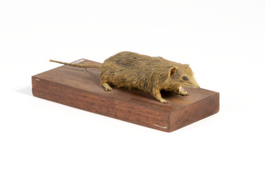 The Beechworth Burke Museum
Animal specimen - Dusky Antechinus, Trustees of the Australian Museum, 1860-1880
... It is most frequently found in mountainous areas, including Kosciuszko National Park and the Brindabella Ranges, where it inhabits alpine heath and tall open forests with dense understorey vegetation. ...It is most frequently found in mountainous areas, including Kosciuszko National Park and the Brindabella Ranges, where it inhabits alpine heath and tall open forests with dense understorey vegetation. ...The dusky antechinus was first described in 1840 by English naturalist George Robert Waterhouse, making it the second species of antechinus to be formally recorded. It was named in honor of zoologist and artist William Swainson, with the holotype likely originating from the Tasman Peninsula in Tasmania, collected by Swainson’s associate, Thomas Lempriere. The dusky antechinus is distributed across southeastern Queensland to southwestern Victoria, as well as in Tasmania. It is most frequently found in mountainous areas, including Kosciuszko National Park and the Brindabella Ranges, where it inhabits alpine heath and tall open forests with dense understorey vegetation. While the species is not considered threatened, some local populations have declined due to habitat loss caused by controlled burning and the replacement of native forests with pine plantations. Additionally, predation by cats and red foxes is believed to negatively impact its numbers. This specimen was originally identified as a bandicoot and is part of a collection of almost 200 animal specimens that were originally acquired as skins from various institutions across Australia, including the Australian Museum and the National Museum of Victoria, as well as individuals such amateur anthropologist Reynell Eveleigh Johns between 1860-1880. These skins were then mounted by members of the Burke Museum Committee and put-on display in the formal space of the Museum’s original exhibition hall where they continue to be on display. This display of taxidermy mounts initially served to instruct visitors to the Burke Museum of the natural world around them, today it serves as an insight into the collecting habits of the 19th century. This specimen is part of a significant and rare taxidermy mount collection in the Burke Museum. This collection is scientifically and culturally important for reminding us of how science continues to shape our understanding of the modern world. They demonstrate a capacity to hold evidence of how Australia’s fauna history existed in the past and are potentially important for future environmental research. This collection continues to be on display in the Museum and has become a key part to interpreting the collecting habits of the 19th century.Small sized dusky antechinus with a pointy snout, small rounded eyes made of glass, a thin tail, small rounded ears, and sharp clawed legs. The fur in colouring is golden brown with streaks of dark brown, and is of medium length and fine.On wooden mount: BMM5896/ On Catalogue Tag (attached to left foreleg): Bandicoot Mou(...)/ Catalogue, Page. 45/ burke museum, taxidermy, taxidermy mount, fauna, animal, animalia, reynell eveleigh johns, bandicoot, marsupial, peramelemorphia, dusky antechinus, antechinus swainsonii, swainson's antechinus, dusky marsupial mouse -
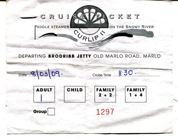 Orbost & District Historical Society
ticket, 8.03.2009
... With the closure of Alpine logging and the creation of vast National Parks, the people of the region needed to create a major undertaking to bond the community and engender… a sense of belonging, this was critical for many of the men, who were dispossessed with the loss of their historical timber and forestry industry." ...With the closure of Alpine logging and the creation of vast National Parks, the people of the region needed to create a major undertaking to bond the community and engender… a sense of belonging, this was critical for many of the men, who were dispossessed with the loss of their historical timber and forestry industry." ...This is a ticket for one adult to cruise on the P.S.Curlip 11 which operated from the Brodribb Jetty in Marlo.from 2007 - 2015. "Paddle Steamer Curlip, a 62 feet long, traditional, plank on frame carved timber vessel, that was built by the people of East Gippsland at Orbost, in far Eastern Victoria. The undertaking to design and build this vessel, as a community project commenced in 2002. The community, based around Orbost was largely dependant on the Timber industry in the surrounding Victorian High Country. With the closure of Alpine logging and the creation of vast National Parks, the people of the region needed to create a major undertaking to bond the community and engender… a sense of belonging, this was critical for many of the men, who were dispossessed with the loss of their historical timber and forestry industry." (Information from website: https://www.curlip.com.au/) The Paddle Steamer Curlip 11 is a reproduction of the historic Curlip a small paddle steamer built by Samuel Richardson and his sons at his Tabbara sawmill near Orbost. It helped open up the region in the 1880’s before road or rail, serviced East Gippsland. Much work is being done to restore the Curlip 11 so that it can begin again as a tourist cruise boat.The P.S.Curlip 11 is Victoria's only Paddle Steamer. It was a community project involving many Orbost peolpe.A rectangular, white paper ticket with black print. In red is No. 1297 and the date and cruise time are hand-written in blue pen. ttached to the back of the ticket is a printed receipt.paddle-steamer-curlip 11 tourism-orbost -
Marysville & District Historical Society
Flyer (item) - Information Flyer, Parks Victoria, Yarra Ranges National Park-Lady Talbot Drive, Cambarville and Lake Mountain-Visitor Guide, 01-2018
... Lake Mountain is the closest alpine cross-country ski resort to Melbourne. lady talbot drive lady talbot forest drive cambarville lake mountain sir reginald talbot lady sarah elizabeth talbot A flyer that was produced as a guide to Lady Talbot Drive, Cambarville and Lake Mountain. Yarra Ranges National Park ...A flyer that was produced as a guide to Lady Talbot Drive, Cambarville and Lake Mountain.A flyer that was produced as a guide to Lady Talbot Drive, Cambarville and Lake Mountain. Lady Talbot Drive a 24 kilometer scenic rainforest car journey which passes a number of walks and waterfalls in the Yarra Ranges National Park. Lady Talbot Drive is named after Lady Sarah Elizabeth, the wife of Sir Reginald Talbot, who was the Governor of Victoria from 25th April, 1904 to 6th July 1908. Cambarville is notable for its giant mountain ash (Eucalyptus regnans) trees within the Cumberland Memorial Scenic Reserve, and relics from former sawmills and gold mining. The Big Culvert is located nearby on the Marysville-Woods Point Road, which was historically part of the Yarra Track. Cambarville was established as a timber mill town in the 1940s. Timber mill owners A Cameron and FJ Barton named Cambarville. They established the mill to salvage timber from trees destroyed in the 1939 bushfires. Cambarville was impacted by the 2009 Black Saturday bushfires and any remaining structures were destroyed. Lake Mountain is the closest alpine cross-country ski resort to Melbourne.lady talbot drive, lady talbot forest drive, cambarville, lake mountain, sir reginald talbot, lady sarah elizabeth talbot -
 Marysville & District Historical Society
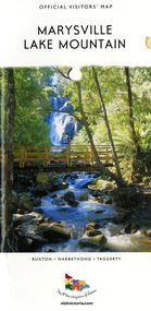
Map (Item) - Tourist map, Mystic Mountains Tourism, OFFICIAL VISITORS' MAP MARYSVILLE LAKE MOUNTAIN, Unknown
... national park...lake mountain-yarra ranges national park...lady talbot drive-yarra ranges national park...cathedral range state park...steavenson river...taggerty river...acheron river...lake mountain alpine...A visitors' map of Marysville and Lake Mountain produced by Mystic Mountains Tourism for Visit Victoria. marysville lake mountain victoria australia visitor's map official visitors' map marysville lake mountain buxton narbethong taggerty visit victoria mystic mountains tourism inc graph attack p/l mystic mountains marysville triangle marysville visitor information centre marylands country house black spur steavenson falls lady talbot drive cambarville cathedral ranges wirreanda festival lake mountain summit walk summit walk loop leadbeaters loop day loop walk buxton hotel igloo roadhouse karmann waters silverstream b&b cottages buxton trout and salmon farm the niche wine bar buxton post office & general store choppers buxton roadhouse woodlands rainforest bungalows chestnut glade black spur inn wombat cottage abbey lake luxury b&b spa cottages mystic mountain ski hire & outdoors pnl 4wdriving blue views holiday units & ski hire marapana agistment park & farm stay b&b danico design things of sand & stone mantirri blueberry farm allawah country cottages amberview cottages ashlar cottage b&b black spur motel & caravan park blackwood deluxe cottages blackwood courtyard b&b dalrymples guest cottages delderfield el kanah guest house fruit salad farm kerami guest house keppels hotel lake mountain-snow gum lodge lomatia lodge lyell guest cottages magnolia house keppel waters lyrebird apartments marysville caravan park all view spa apartments riverside cottages maryton park b&b country cottages melina cottage mountain lodge mystic mountains holiday cottages nanda binya lodge rendezvous luxury cottages scenic b&b motel the cumberland south cathedral farm tower motel willowbank at taggerty woodlands rainforest retreat marysville & district country club inc mystic mountains ski hire & outdoors rubicon valley horse riding marysville trout and salmon ponds gallipoli park keppels lookout cambarville-yarra ranges national park lake mountain-yarra ranges national park lady talbot drive-yarra ranges national park cathedral range state park steavenson river taggerty river acheron river lake mountain alpine resort bruno's art and sculpture garden manical mechanicals uncle fred & aunty val's old style lolly shop carmyle farm boutique crossways historic country inn fraga's gilberts restaurant heights licensed bistro the old woolshed cafe cathedral view natural therapies crystal journey The Marysville and Lake Mountain Visitor Map and Touring Guide has been compiled and/ published by Mystic Mountains Tourism Inc. ...A visitors' map of Marysville and Lake Mountain produced by Mystic Mountains Tourism for Visit Victoria.A visitors' map of Marysville and Lake Mountain produced by Mystic Mountains Tourism for Visit Victoria.The Marysville and Lake Mountain Visitor Map and Touring Guide has been compiled and/ published by Mystic Mountains Tourism Inc. Copyright./ Production and artwork Graph Attack P/Lmarysville, lake mountain, victoria, australia, visitor's map, official visitors' map marysville lake mountain, buxton, narbethong, taggerty, visit victoria, mystic mountains tourism inc, graph attack p/l, mystic mountains, marysville triangle, marysville visitor information centre, marylands country house, black spur, steavenson falls, lady talbot drive, cambarville, cathedral ranges, wirreanda festival, lake mountain summit walk, summit walk loop, leadbeaters loop, day loop walk, buxton hotel, igloo roadhouse, karmann waters, silverstream b&b cottages, buxton trout and salmon farm, the niche wine bar, buxton post office & general store, choppers buxton roadhouse, woodlands rainforest bungalows, chestnut glade, black spur inn, wombat cottage, abbey lake luxury b&b spa cottages, mystic mountain ski hire & outdoors, pnl 4wdriving, blue views holiday units & ski hire, marapana agistment park & farm stay b&b, danico design, things of sand & stone, mantirri blueberry farm, allawah country cottages, amberview cottages, ashlar cottage b&b, black spur motel & caravan park, blackwood deluxe cottages, blackwood courtyard b&b, dalrymples guest cottages, delderfield, el kanah guest house, fruit salad farm, kerami guest house, keppels hotel, lake mountain-snow gum lodge, lomatia lodge, lyell guest cottages, magnolia house, keppel waters, lyrebird apartments, marysville caravan park, all view spa apartments, riverside cottages, maryton park b&b country cottages, melina cottage, mountain lodge, mystic mountains holiday cottages, nanda binya lodge, rendezvous luxury cottages, scenic b&b motel, the cumberland, south cathedral farm, tower motel, willowbank at taggerty, woodlands rainforest retreat, marysville & district country club inc, mystic mountains ski hire & outdoors, rubicon valley horse riding, marysville trout and salmon ponds, gallipoli park, keppels lookout, cambarville-yarra ranges national park, lake mountain-yarra ranges national park, lady talbot drive-yarra ranges national park, cathedral range state park, steavenson river, taggerty river, acheron river, lake mountain alpine resort, bruno's art and sculpture garden, manical mechanicals, uncle fred & aunty val's old style lolly shop, carmyle farm boutique, crossways historic country inn, fraga's, gilberts restaurant, heights licensed bistro, the old woolshed cafe, cathedral view natural therapies, crystal journey -
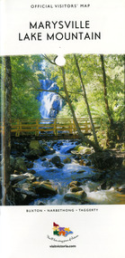 Marysville & District Historical Society
Map (Item) - Tourist map, Mystic Mountains Tourism, OFFICIAL VISITORS' MAP MARYSVILLE LAKE MOUNTAIN, Unknown
... national park...lake mountain-yarra ranges national park...lady talbot drive-yarra ranges national park...cathedral range state park...steavenson river...taggerty river...acheron river...lake mountain alpine...A visitors' map of Marysville and Lake Mountain produced by Mystic Mountains Tourism for Visit Victoria. marysville lake mountain victoria australia visitor's map official visitors' map marysville lake mountain buxton narbethong taggerty visit victoria mystic mountains tourism inc graph attack p/l mystic mountains marysville triangle marysville visitor information centre marylands country house black spur steavenson falls lady talbot drive cambarville cathedral ranges wirreanda festival lake mountain summit walk summit walk loop leadbeaters loop day loop walk buxton hotel igloo roadhouse karmann waters silverstream b&b cottages buxton trout and salmon farm the niche wine bar buxton post office & general store choppers buxton roadhouse woodlands rainforest bungalows chestnut glade black spur inn wombat cottage abbey lake luxury b&b spa cottages mystic mountain ski hire & outdoors pnl 4wdriving blue views holiday units & ski hire marapana agistment park & farm stay b&b danico design things of sand & stone mantirri blueberry farm allawah country cottages amberview cottages ashlar cottage b&b black spur motel & caravan park blackwood deluxe cottages blackwood courtyard b&b dalrymples guest cottages delderfield el kanah guest house fruit salad farm kerami guest house keppels hotel lake mountain-snow gum lodge lomatia lodge lyell guest cottages magnolia house keppel waters lyrebird apartments marysville caravan park all view spa apartments riverside cottages maryton park b&b country cottages melina cottage mountain lodge mystic mountains holiday cottages nanda binya lodge rendezvous luxury cottages scenic b&b motel the cumberland south cathedral farm tower motel willowbank at taggerty woodlands rainforest retreat marysville & district country club inc mystic mountains ski hire & outdoors rubicon valley horse riding marysville trout and salmon ponds gallipoli park keppels lookout cambarville-yarra ranges national park lake mountain-yarra ranges national park lady talbot drive-yarra ranges national park cathedral range state park steavenson river taggerty river acheron river lake mountain alpine resort bruno's art and sculpture garden manical mechanicals uncle fred & aunty val's old style lolly shop carmyle farm boutique crossways historic country inn fraga's gilberts restaurant heights licensed bistro the old woolshed cafe cathedral view natural therapies crystal journey The Marysville and Lake Mountain Visitor Map and Touring Guide has been compiled and/ published by Mystic Mountains Tourism Inc. ...A visitors' map of Marysville and Lake Mountain produced by Mystic Mountains Tourism for Visit Victoria.A visitors' map of Marysville and Lake Mountain produced by Mystic Mountains Tourism for Visit Victoria.The Marysville and Lake Mountain Visitor Map and Touring Guide has been compiled and/ published by Mystic Mountains Tourism Inc. Copyright./ Production and artwork Graph Attack P/Lmarysville, lake mountain, victoria, australia, visitor's map, official visitors' map marysville lake mountain, buxton, narbethong, taggerty, visit victoria, mystic mountains tourism inc, graph attack p/l, mystic mountains, marysville triangle, marysville visitor information centre, marylands country house, black spur, steavenson falls, lady talbot drive, cambarville, cathedral ranges, wirreanda festival, lake mountain summit walk, summit walk loop, leadbeaters loop, day loop walk, buxton hotel, igloo roadhouse, karmann waters, silverstream b&b cottages, buxton trout and salmon farm, the niche wine bar, buxton post office & general store, choppers buxton roadhouse, woodlands rainforest bungalows, chestnut glade, black spur inn, wombat cottage, abbey lake luxury b&b spa cottages, mystic mountain ski hire & outdoors, pnl 4wdriving, blue views holiday units & ski hire, marapana agistment park & farm stay b&b, danico design, things of sand & stone, mantirri blueberry farm, allawah country cottages, amberview cottages, ashlar cottage b&b, black spur motel & caravan park, blackwood deluxe cottages, blackwood courtyard b&b, dalrymples guest cottages, delderfield, el kanah guest house, fruit salad farm, kerami guest house, keppels hotel, lake mountain-snow gum lodge, lomatia lodge, lyell guest cottages, magnolia house, keppel waters, lyrebird apartments, marysville caravan park, all view spa apartments, riverside cottages, maryton park b&b country cottages, melina cottage, mountain lodge, mystic mountains holiday cottages, nanda binya lodge, rendezvous luxury cottages, scenic b&b motel, the cumberland, south cathedral farm, tower motel, willowbank at taggerty, woodlands rainforest retreat, marysville & district country club inc, mystic mountains ski hire & outdoors, rubicon valley horse riding, marysville trout and salmon ponds, gallipoli park, keppels lookout, cambarville-yarra ranges national park, lake mountain-yarra ranges national park, lady talbot drive-yarra ranges national park, cathedral range state park, steavenson river, taggerty river, acheron river, lake mountain alpine resort, bruno's art and sculpture garden, manical mechanicals, uncle fred & aunty val's old style lolly shop, carmyle farm boutique, crossways historic country inn, fraga's, gilberts restaurant, heights licensed bistro, the old woolshed cafe, cathedral view natural therapies, crystal journey -
Marysville & District Historical Society
THE TRIANGLE NEWS-VOL 41 NO 11-MARCH 28 2014
... national emergency medal presentation...free community event...residential and rural real estate...marysville triangle real estate...fire prevention irrigation systems...golf & bowls club house renovations proceeding well...buxton hotel chinese night...holly eradication program at narbethong...rock 'n roll night at buxton hall...marysville & district football & netball club season opener launch...marysville villains...marysville preschool centre...long day care & kindergarten...marysville beer and platter garden...dinner & auction fundraiser...marysville triangle youth...marysville brownies guides...narbethong hall...news from the gallipoli park precinct committee of management...lake mountain alpine...marysville victoria australia new boardwalk among the gum trees celebrate first national eucalyptus day new contact details for triangle news what's on when in march friends of the marysville walks working bee at steavenson falls the committee of management of the gallipoli park precinct marysville community market creative triangle village walk marysville shop to lease triangle community dinner el kanah village church notices mystic mountains tourism marysville & district chamber of commerce special general members meeting dog & cat registrations due mayor's chair positions vacant marysville cultural community agm lions rich fruit cakes advertisements cfa national emergency medal presentation free community event residential and rural real estate marysville triangle real estate fire prevention irrigation systems golf & bowls club house renovations proceeding well buxton hotel chinese night holly eradication program at narbethong rock 'n roll night at buxton hall marysville & district football & netball club season opener launch marysville villains marysville preschool centre long day care & kindergarten marysville beer and platter garden dinner & auction fundraiser marysville triangle youth marysville brownies guides narbethong hall news from the gallipoli park precinct committee of management lake mountain alpine resort casual employment available alpine resort iconic bridge officially opened sports & recreation grants to improve facilities THE TRIANGLE NEWS-VOL 41 NO 11-MARCH 28 2014 ...marysville, victoria, australia, new boardwalk among the gum trees, celebrate first national eucalyptus day, new contact details for triangle news, what's on when in march, friends of the marysville walks working bee at steavenson falls, the committee of management of the gallipoli park precinct, marysville community market, creative triangle, village walk marysville shop to lease, triangle community dinner, el kanah village, church notices, mystic mountains tourism, marysville & district chamber of commerce, special general members meeting, dog & cat registrations due, mayor's chair, positions vacant, marysville cultural community agm, lions rich fruit cakes, advertisements, cfa national emergency medal presentation, free community event, residential and rural real estate, marysville triangle real estate, fire prevention irrigation systems, golf & bowls club house renovations proceeding well, buxton hotel chinese night, holly eradication program at narbethong, rock 'n roll night at buxton hall, marysville & district football & netball club season opener launch, marysville villains, marysville preschool centre, long day care & kindergarten, marysville beer and platter garden, dinner & auction fundraiser, marysville triangle youth, marysville brownies guides, narbethong hall, news from the gallipoli park precinct committee of management, lake mountain alpine resort, casual employment available alpine resort, iconic bridge officially opened, sports & recreation grants to improve facilities -
 Wodonga & District Historical Society Inc
Book - The Campaign Fires - North-East/East Gippsland Fires 2003, Lyndel Hunter, 2003
... Alpine bushfires started on 8 January 2003, a day of Total Fire Ban. Lightning ignited 87 fires in the North-East and East Gippsland regions. Eight of these fires were unable to be contained; they joined together to form the largest fire in Victoria since the Black Friday fires in 1939. The majority of the area burnt in Victoria was public land, 1.19 million hectares of parks and forests, including 60 per cent of the Alpine National ...A description of efforts to fight the bushfires in Gippsland in 2003, including maps and illustrations This volume was published as a tribute to the work of staff and volunteers who put themselves at risk to protect local communities. It shows the impact on those communities in Victoria and the support they gave to those involved in fighting largest bushfires in Victoria for 60 years. The Alpine bushfires started on 8 January 2003, a day of Total Fire Ban. Lightning ignited 87 fires in the North-East and East Gippsland regions. Eight of these fires were unable to be contained; they joined together to form the largest fire in Victoria since the Black Friday fires in 1939. The majority of the area burnt in Victoria was public land, 1.19 million hectares of parks and forests, including 60 per cent of the Alpine National Park and 81 per cent of the Mt Buffalo National Park. Firefighting efforts were made difficult in hard to access, remote forest terrain. Approximately 90,000 hectares of private land was burnt.This publication of 119 pages features text, colour images, maps and detailed information related to the 2003 bushfires in Victoria.non-fictionA description of efforts to fight the bushfires in Gippsland in 2003, including maps and illustrations This volume was published as a tribute to the work of staff and volunteers who put themselves at risk to protect local communities. It shows the impact on those communities in Victoria and the support they gave to those involved in fighting largest bushfires in Victoria for 60 years. The Alpine bushfires started on 8 January 2003, a day of Total Fire Ban. Lightning ignited 87 fires in the North-East and East Gippsland regions. Eight of these fires were unable to be contained; they joined together to form the largest fire in Victoria since the Black Friday fires in 1939. The majority of the area burnt in Victoria was public land, 1.19 million hectares of parks and forests, including 60 per cent of the Alpine National Park and 81 per cent of the Mt Buffalo National Park. Firefighting efforts were made difficult in hard to access, remote forest terrain. Approximately 90,000 hectares of private land was burnt.forest fires -- victoria, bushfires, fires prevention and control -
 Parks Victoria - Mount Buffalo Chalet
Skates
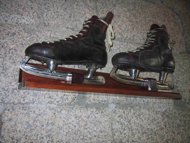
... National Park Mt Buffalo high-country Ice skates used to skate on Lake Catani. Ice skating was a popular activity for guest and visitors to Mt Buffalo. Ice skates were provided for hire by the the first Lessee of the Chalet, John Newton and also Norwegian born Hilda Samsing, who took over from him in 1919 and did much to pioneer and promote winter sports in the Victorian Alpine region . ...Ice skates used to skate on Lake Catani. Ice skating was a popular activity for guest and visitors to Mt Buffalo. Ice skates were provided for hire by the the first Lessee of the Chalet, John Newton and also Norwegian born Hilda Samsing, who took over from him in 1919 and did much to pioneer and promote winter sports in the Victorian Alpine region . Ice cover on the Lake has not been sufficient for safe skating for many decades. 'After its initial popularity, skating at Mount Buffalo dwindled in the post-war years. According to Museum Victoria curator, Michelle Stevenson, few collections hold historic ice-skates, so any early examples identified in the Chalet collection will be important for their rarity." (Pg 94. Historica) 'Ice-skating was a popular recreational activity in the later nineteenth and early twentieth centuries...According to Michelle Stevenson, Australian Collections hold little material culture relating to its practice other than images and film. The few pairs of ice skates in the Chalet collection, which are in good condition, are important for their rarity as well as for illustrating the popularity of skating on Lake Catani prior to WW2.' Pair of black leather ice scates, mounted on wall. Skates feature white laces, metal blades and brown leather reinforcing area around laces and ankles.Boots are stffed with 1993 newsprint.On skate blade, "Made in Canada 11 1/3 CCM / Senior A" On boot sole , "Made by J Molony " plus worn name label. -
 Parks Victoria - Mount Buffalo Chalet
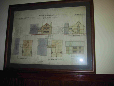
Plans x 4, " Additions to Government Chalet Mt Buffalo
... National Park Mt Buffalo high-country Original plans for the Mount Buffalo Chalet, framed architectural drawings for the Chalet, titled " Additions to Government Chalet Mt Buffalo. Dated 1909. Signed Jas G Spence & E F Leary. "Ground Plan, first floor plan, elevation, Section M5 and side elevation –beautiful coloured plan, hand price onit of £970, also called Drawing No. 1.Beautiful plan suitable for reproduction for graphic work." (Pg 45. Heritage Impact Assessment, September 2013. MGS Architects and McDougall & Vines, Conservation and Heritage Consultants) 'The Mount Buffalo Chalet opened in April 1910 as a remarkable Victorian State government venture into alpine ...Original plans for the Mount Buffalo Chalet, framed architectural drawings for the Chalet, titled " Additions to Government Chalet Mt Buffalo. Dated 1909. Signed Jas G Spence & E F Leary. "Ground Plan, first floor plan, elevation, Section M5 and side elevation –beautiful coloured plan, hand price onit of £970, also called Drawing No. 1.Beautiful plan suitable for reproduction for graphic work." (Pg 45. Heritage Impact Assessment, September 2013. MGS Architects and McDougall & Vines, Conservation and Heritage Consultants) 'The Mount Buffalo Chalet opened in April 1910 as a remarkable Victorian State government venture into alpine tourism and recreation. Designed by Public works Department architect, George Austin (1860-1921)." (Pg 4 Historica, 2011). "The collection of ephemera builds on the Chalet's holding of archival material with a range of interesting, original items. Dinner menus., stationery., luggage labels, tickets, dockets and plans help to interpret the structured routine and social conventions of the Chalet that held sway for so many years." (pg 127 MBCC) These plans drawn were most likely to have been drawn upon recommendation by Government Tourist Officer, J.C.Boyce. John Newton (the Lessee) suggests the addition of 2 new wings (24 rooms) and creation of a billiards room. Treasury approved money for these extensions which were not completed until1914. Listed in Draft Inventory of Significant Collection Items. Four framed hand-drawn and coloured drawings / plans of the Chalet. Framed and mounted behind glass. 1: Dated 1911 -1912. 2: -dated 6th oct 1909 3: -Dated 25th Sept 1909. 4: -Dated 6th Oct 1909.Handwritten at the top of each drawing," Mount Buffalo / Wood Chalet"