
Showing 44 items matching "beaconsfield road"
-
 Emerald Museum & Nobelius Heritage Park
Photograph - Beaconsfield Road, Emerald, Circa 1948
... Beaconsfield Road, Emerald......Beaconsfield Road...Beaconsfield Road, Emerald. The Coffee Palace 1948....Emerald Victoria Australia buildings roads and streets Beaconsfield Road Emerald Coffee Palace Beaconsfield Road, Emerald. ...Black and white original photograph, 1950sBeaconsfield Road, Emerald. The Coffee Palace 1948.emerald, victoria, australia, buildings, roads and streets, beaconsfield road, emerald coffee palace -
 Hawthorn Historical Society
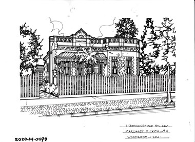
Drawing - Property Illustration, 1 Beaconsfield Road, Hawthorn
... 1 Beaconsfield Road, Hawthorn...Pen and ink property illustration on drafting film of 1 Beaconsfield Road, Hawthorn by Margaret Picken....1 Beaconsfield Road, Hawthorn, Margaret Picken '94. ...Pen and ink property illustration on drafting film of 1 Beaconsfield Road, Hawthorn by Margaret Picken. 1 Beaconsfield Road, Hawthorn Drawing Property Illustration ...'After training as a Cartographic Draftsman within the mining industry, I worked as a property illustrator for real estate firms in the eastern suburbs of Melbourne for 23 years from 1983. I initially photographed houses with a Polaroid camera and made a 'thumbnail' sketch while there. The photos were used to scale off a sketch in pencil and then that sketch was overlaid with drafting film and the 'pen and ink' completed. The pens I used were the Rotring ‘Rapidigraph’ drafting pens. The ink was also made by Rotring (German).The film was ‘Rapidraw’, polyester drafting film, double matte. It takes a very fine line and doesn’t bleed. As well as house sketches, there were often floor plans and site plans ordered. Aerial sketches were ordered when the property needed an overall view.' (Margaret Picken, 2020)This property illustration is one of a series created by Margaret Picken for a range of real estate agents in Melbourne between c. 1983 and c. 2006. Each work is signed and dated by the artist.Gift of Margaret Picken, 2020Pen and ink property illustration on drafting film of 1 Beaconsfield Road, Hawthorn by Margaret Picken.1 Beaconsfield Road, Hawthorn, Margaret Picken '94. Woodards - Hawthorn.artist - margaret picken 1950- -
 Hawthorn Historical Society
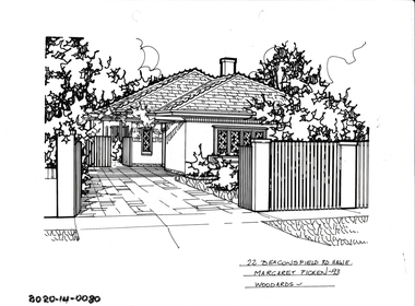
Drawing - Property Illustration, 22 Beaconsfield Road, Hawthorn
... 22 Beaconsfield Road, Hawthorn...Pen and ink property illustration on drafting film of 22 Beaconsfield Road, Hawthorn by Margaret Picken....22 Beaconsfield Road, Haw E, Margaret Picken '93. Woodards - Hawthorn....Pen and ink property illustration on drafting film of 22 Beaconsfield Road, Hawthorn by Margaret Picken. 22 Beaconsfield Road, Hawthorn Drawing Property Illustration ...'After training as a Cartographic Draftsman within the mining industry, I worked as a property illustrator for real estate firms in the eastern suburbs of Melbourne for 23 years from 1983. I initially photographed houses with a Polaroid camera and made a 'thumbnail' sketch while there. The photos were used to scale off a sketch in pencil and then that sketch was overlaid with drafting film and the 'pen and ink' completed. The pens I used were the Rotring ‘Rapidigraph’ drafting pens. The ink was also made by Rotring (German).The film was ‘Rapidraw’, polyester drafting film, double matte. It takes a very fine line and doesn’t bleed. As well as house sketches, there were often floor plans and site plans ordered. Aerial sketches were ordered when the property needed an overall view.' (Margaret Picken, 2020)This property illustration is one of a series created by Margaret Picken for a range of real estate agents in Melbourne between c. 1983 and c. 2006. Each work is signed and dated by the artist.Gift of Margaret Picken, 2020Pen and ink property illustration on drafting film of 22 Beaconsfield Road, Hawthorn by Margaret Picken.22 Beaconsfield Road, Haw E, Margaret Picken '93. Woodards - Hawthorn.artist - margaret picken 1950- -
 Emerald Museum & Nobelius Heritage Park
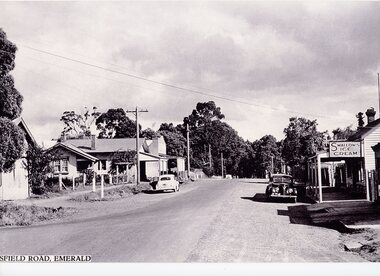
Photograph - Emerald-Beaconsfield Road 1940s, 1940s
... Emerald-Beaconsfield Road 1940s...This photograph was taken on Beaconsfield Road in Emerald (now Kilvington Drive) looking from Emerald Main Street towards the train line. ...Below image (Start cut off): "SFIELD ROAD, EMERALD" (Originally "BEACONSFIELD ROAD, EMERALD")...Photograph Emerald-Beaconsfield Road 1940s ...This photograph was taken on Beaconsfield Road in Emerald (now Kilvington Drive) looking from Emerald Main Street towards the train line. In the right of the image is the Teasdale store, on the location now used for storage by the Emerald Village Bakery. The store was owned by Joseph and Nell Teasdale, with Joseph's brother Edward operating a leatherworking business behind the store. Joseph and Nell's son, Kevin, suggested that what is now called Stapleton Walk instead be named "Forge Lane or Forge Walk," rather than solely representing Charles Stapleton's business across the lane from the Teasdales. On the left of the image is a sign denoting a school - possibly a back entrance to the nearby Emerald Primary School (number 3381) through the school oval. There are also other stores on the left, including what appears to be a newsagents. This is a copy of the original photograph; parts of the label have been lost in the process.This photograph depicts Emerald in the 1940s, showing several stores no longer in existence.A black and white photograph centered on an unsealed commercial road with shops on either side. One shop has a sign advertising Swallows Ice Cream, and another the Age and Leader newspapers. 1940s-style cars are parked on either side.Below image (Start cut off): "SFIELD ROAD, EMERALD" (Originally "BEACONSFIELD ROAD, EMERALD")emerald, transport, teasdale family, 1940s, commerce -
Emerald Museum & Nobelius Heritage Park
Photograph - Beaconsfield Road streetscape, c1948, 1948
... Beaconsfield Road streetscape, c1948...Photograph of three children standing on Beaconsfield Road (present-day Kilvington Drive). ...On back of photo written in biro (presumably by Kevin Teasdale): 'Emerald Streetscape looking along Beaconsfield Road (now Kilvington Drive) towards Belgrave-Gembrook Road, from in front of the Police Residence c1948. ...Photograph of three children standing on Beaconsfield Road (present-day Kilvington Drive). ...The Teasdale family were shop proprietors in the 1940s in Emerald. Kevin Teasdale has written extensively about Emerald in that period. His writings are contained with photographs in his family folder in Filing Cabinet 6C.Black and white rectangular photograph printed on matte photographic paper. Photograph of three children standing on Beaconsfield Road (present-day Kilvington Drive). The view looks toward Belgrave-Gembrook Road . Local shops (the Teasdale boot shop and fruit shop, Hogan's Coffee Palace and Legge's store are just visible. The three children are presumably Kevin and his younger siblings.On back of photo written in biro (presumably by Kevin Teasdale): 'Emerald Streetscape looking along Beaconsfield Road (now Kilvington Drive) towards Belgrave-Gembrook Road, from in front of the Police Residence c1948. On the left side, Edward Teasdale's bootshop, Hogan's Coffee Palace & my parents' fruit shop are visible. On the right side, Legges' "The Big Store" is visible.'kevin teasdale, 1940s, kilvington drive, shops -
 Emerald Museum & Nobelius Heritage Park
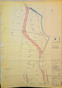
Map - Municipality Road Classification - Beaconsfield - Emerald Rd., Shire of Berwick Alteration 1973, c1973
... Municipality Road Classification - Beaconsfield - Emerald Rd., Shire of Berwick Alteration 1973...Municipality Road Classification - Beaconsfield - Emerald Rd., Shire of Berwick Alteration 1973...Image of map indicating Municipality Road Classification - Beaconsfield - Emerald Rd., Shire of Berwick Alteration 1973...Title Survey Division/Crown description/Crown allotment 47A and Part of Crown allotments1,46,47, 48A and former Government Rd., Parish of Gembrook, County of Mornington/Municipality Road Classification/Shire of Berwick, Beaconsfield-Emerald Road/Signed (Unreadable) Principal Title Survey Officer and Proper Officer 13.8.1973/SP13349...Title Survey Division/Crown description/Crown allotment 47A and Part of Crown allotments1,46,47, 48A and former Government Rd., Parish of Gembrook, County of Mornington/Municipality Road Classification/Shire of Berwick, Beaconsfield-Emerald Road/Signed (Unreadable) Principal Title Survey Officer and Proper Officer 13.8.1973/SP13349 Image of map indicating Municipality Road Classification - Beaconsfield - Emerald Rd., Shire of Berwick Alteration 1973 Municipality Road Classification - Beaconsfield - Emerald Rd., Shire of Berwick Alteration 1973 Map Municipality Road Classification - Beaconsfield - Emerald Rd., Shire of Berwick Alteration 1973 ...Image of map indicating Municipality Road Classification - Beaconsfield - Emerald Rd., Shire of Berwick Alteration 1973Title Survey Division/Crown description/Crown allotment 47A and Part of Crown allotments1,46,47, 48A and former Government Rd., Parish of Gembrook, County of Mornington/Municipality Road Classification/Shire of Berwick, Beaconsfield-Emerald Road/Signed (Unreadable) Principal Title Survey Officer and Proper Officer 13.8.1973/SP13349 -
Emerald Museum & Nobelius Heritage Park
Geological specimen - Multilayered Paint Chips
... ...Emerald Beaconsfield Road...Emerald-Beaconsfield Road...Elephant Rock Emerald Beaconsfield Road Emerald Victoria Australia Mulilayered and multicoloured section chipped off Elephant Rock. ...Elephant Rock is an example of the many granite outcrops in the area. it is a large rock made up of 2 parts, resembling an elephant. It is positioned on a main thoroughfare between Emerald and Beaconsfield and is regularly painted by locals, generally for special occasions.Mulilayered and multicoloured section chipped off Elephant Rock. The colours vary from pink to pale blue to yellow then green. It was part of a granite outcrop known as Elephant Rock on the Emerald Beaconsfield Rd, that is regularly repainted by locals, with slogans, grafitti and art workelephant rock, emerald beaconsfield road, emerald, victoria, australia -
 Emerald Museum & Nobelius Heritage Park
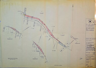
Map - Image of Surveyors Map of road classification - Beaconsfield-Emerald Rd. near Summit Ave., Emerald 1973, Crown allotment and former Govt. Road classification - Beaconsfield-Emerald Rd. near summit Ave., Emerald 1973, c1973
... Image of Surveyors Map of road classification - Beaconsfield-Emerald Rd. near Summit Ave., Emerald 1973...Crown allotment and former Govt. Road classification - Beaconsfield-Emerald Rd. near summit Ave., Emerald 1973... classification - Beaconsfield-Emerald Rd. near summit Ave., Emerald 1973 Map Image of Surveyors Map of road classification - Beaconsfield-Emerald Rd. near Summit Ave., Emerald 1973 ...Image of Surveyors map indicating changes to Beaconsfield-Emerald Rd., near Summit Ave., EmeraldTitle Survey Division/Crown Description/Part of Crown Allotment and Former Government Rd., Parish of Gembrook, County of Mornington -
 Emerald Museum & Nobelius Heritage Park
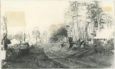
Photograph - Moffat's Store, B. James Whiting, c. 1900
... Annotation: "Moffats Store 1900 / Cr Beaconsfield Road & Main Rd / Then Paternoster Rd"...Cr Main Street & Beaconsfield-Emerald Road, Emerald, Victoria, 3782, Australia...Moffatt Annotation: "Moffats Store 1900 / Cr Beaconsfield Road & Main Rd / Then Paternoster Rd" Black and white photograph depicting an unpaved road with buildings on either side; the building in the foreground on the right has a porch and people standing in front of it. ...The donor was a former captain of the Emerald Golf Club. Archibald & W. Moffat's grocery store was a significant business in early Emerald, selling groceries to the local community.This photograph captures the townscape of Emerald during the town's early growth phase, featuring a significant local institution.Black and white photograph depicting an unpaved road with buildings on either side; the building in the foreground on the right has a porch and people standing in front of it. On the left, buildings are in the distant background. Tall trees rise in the background on the right, with more distant trees visible further behind on the left. An individual appears to be walking down the road in the distance.Annotation: "Moffats Store 1900 / Cr Beaconsfield Road & Main Rd / Then Paternoster Rd"1900s, emerald, commerce, w. moffatt -
 Eltham District Historical Society Inc
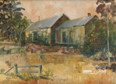
Painting, C. Lillie Brown, Briar Hill Cottage by C. Lillie Brown
... 25 Beaconsfield Road, Briar Hill, Miss Humphries, Lolly Shop, Briar Hill School...Lillie Brown (Caroline) of house at 25 Beaconsfield Road, Briar Hill, formnerly owned by Miss Humphries who ran a lolly shop in the left hand sode of the building. ...Lillie Brown (Caroline) of house at 25 Beaconsfield Road, Briar Hill, formnerly owned by Miss Humphries who ran a lolly shop in the left hand sode of the building. ...Painting by C. Lillie Brown (Caroline) of house at 25 Beaconsfield Road, Briar Hill, formnerly owned by Miss Humphries who ran a lolly shop in the left hand sode of the building. Frequented by children from the Briar Hill school which was opposite. House now demolished.29.2 x 39.1 cm Oil on (Fredrix USA) linen mounted paper board 12" x 16 " (30.5 x 40.6 cm) in standard frame Signed in brown paint lower left C Lillie Brown25 beaconsfield road, briar hill, miss humphries, lolly shop, briar hill school -
 Emerald Museum & Nobelius Heritage Park
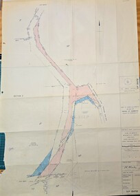
Map - Survey Map - Municipality Road Classification - Beaconsfield-Emerald Rd. (near Downey Rd.) 1972, Title Survey Division, Crown Description - part of Crown Allotments 39A and 39D, Parish of Gembrook, County of Mornington, c1972
... Survey Map - Municipality Road Classification - Beaconsfield-Emerald Rd. (near Downey Rd.) 1972...Title Survey Division/Crown Description/Part of Crown Allotments 39A and 39D, Parish of Gembrook,County of Mornington/Municipality Road Classification - Shire of Berwick, Beaconsfield - Emerald Rd, Upper Beaconsfield - Upper Pakenham Road/John L Dwyer of Fisher Cleeland Turner & Dwyer Pty. ...Title Survey Division/Crown Description/Part of Crown Allotments 39A and 39D, Parish of Gembrook,County of Mornington/Municipality Road Classification - Shire of Berwick, Beaconsfield - Emerald Rd, Upper Beaconsfield - Upper Pakenham Road/John L Dwyer of Fisher Cleeland Turner & Dwyer Pty. ...Image of Crown survey map - changes to allotments bordering Beaconsfield-Emerald Rd. near Downey Rd. in 1972Title Survey Division/Crown Description/Part of Crown Allotments 39A and 39D, Parish of Gembrook,County of Mornington/Municipality Road Classification - Shire of Berwick, Beaconsfield - Emerald Rd, Upper Beaconsfield - Upper Pakenham Road/John L Dwyer of Fisher Cleeland Turner & Dwyer Pty. Ltd., 213 King Street, Melbourne - 14 April, 1972/S.R. CLARKE - Principal Title Survey Officer 5.9.72/SP 13072 -
 Emerald Museum & Nobelius Heritage Park
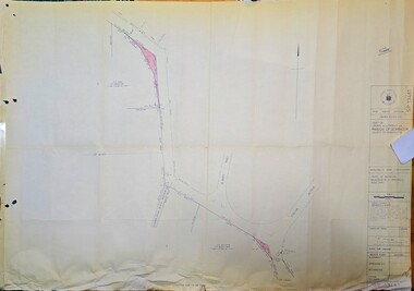
Map - Municipality Road Classification - Beaconsfield-Emerald Rd., Shire of Gembrook 1973, Title Survey Division, Crown Description - Part of Crown Allotment 44, Parish of Gembrook, County of Mornington, c1973
... Municipality Road Classification - Beaconsfield-Emerald Rd., Shire of Gembrook 1973...Road Classification, Shire of Berwick, Beaconsfeld-Emerald Rd. (MR)/Francis J Webber of Kirkpatrick & Webber, 285 Maroondah Hwy., Ringwood/(Signed) - Principal Title Survey Office 16.1.73/SP13461 Image of Crown Survey Map for crown allotment 44 (Beaconsfield-Emerald Rd.) parish of Gembrook, County of Mornington Title Survey Division, Crown Description - Part of Crown Allotment 44, Parish of Gembrook, County of Mornington Map Municipality Road Classification - Beaconsfield-Emerald Rd., Shire of Gembrook 1973 ...Image of Crown Survey Map for crown allotment 44 (Beaconsfield-Emerald Rd.) parish of Gembrook, County of MorningtonTitle Survey Division/Crown Description/Part of Crown Allotment 44, Parish of Gembrook, County of Mornington/Municipality Road Classification, Shire of Berwick, Beaconsfeld-Emerald Rd. (MR)/Francis J Webber of Kirkpatrick & Webber, 285 Maroondah Hwy., Ringwood/(Signed) - Principal Title Survey Office 16.1.73/SP13461 -
Eltham District Historical Society Inc
Document - Folder, Spence, Maxwell
... ...Beaconsfield Road Briar Hill...Maxwell Spence Briar Hill Montmorency Fernside Avenue Briar Hill Montmorency State School Were Street Montmorency Briar Hill State School Stan Stainsby Hee Alcock Ned Haughton Australian Paper Mills Lovitool Tomasetti baker of Greensborough Gladstone Avenue Briar Hill Beaconsfield Road Briar Hill Williams Road Briar Hill Ellis family Hillcrest playfield field Ben Barnett Bill Slater Colin Pugh Clifton Pugh St Helena Karingal Drive St Helena Ted Walker Weidligh Roslind Miller Graham Kennedy Jimmy Beale Leach Street St Helena Plenty River St Faith's Chrch of England Briar Hil St Andrew's Church Briar Hill St Francis Xavier Catholic Church Briar Hill Herbie Wilson Victoria Coffee Palace Eltham Higher Elementary School Kate McKenie Diamond Creek Frank Phillips Wingrove Park Bremner's Park Orrs Dam Pecks Dam Wal Scriver Montmorency Tennis Club Albert Price Hill Fred Balaam Greensborough RSL Joe Poulter Fairfield RSL Youth Club Bristcoes Hardware Merchants Montmorency RSL Jack Shallard Ted Weiland Petrie Park South Riding Ratepaers and Tenants Association Dr Keith Alexander Fred Durham Eltham Shire Council Meruka Park Max Watson Eric Harmer Spence Park Montmorency Mountain View Railway Bridge Montmrency Pre School Lower Plenty Fire Brigade Eltham High School Newspaper clippings, A4 photocopies, etc Spence, Maxwell Document Folder ...Max Spence came to Briar Hill as a child in 1923, and lived in the area for many years. Contents Typed and manuscript notes (2pp missing from MS), undated but ?c1990. "Spence: My Briar Hill and Montmorency." Reminiscences of Maxwell Spence of Briar Hill and Montmorency from 1923. Manuscript notes, AGM 1991, "Max Spence". Newspaper clippings, A4 photocopies, etcmaxwell spence, briar hill, montmorency, fernside avenue briar hill, montmorency state school, were street montmorency, briar hill state school, stan stainsby, hee alcock, ned haughton, australian paper mills, lovitool, tomasetti baker of greensborough, gladstone avenue briar hill, beaconsfield road briar hill, williams road briar hill, ellis family, hillcrest playfield field, ben barnett, bill slater, colin pugh, clifton pugh, st helena, karingal drive st helena, ted walker, weidligh, roslind miller, graham kennedy, jimmy beale, leach street st helena, plenty river, st faith's chrch of england briar hil, st andrew's church briar hill, st francis xavier catholic church briar hill, herbie wilson, victoria coffee palace, eltham higher elementary school, kate mckenie, diamond creek, frank phillips, wingrove park, bremner's park, orrs dam, pecks dam, wal scriver, montmorency tennis club, albert price hill, fred balaam, greensborough rsl, joe poulter, fairfield rsl youth club, bristcoes hardware merchants, montmorency rsl, jack shallard, ted weiland, petrie park, south riding ratepaers and tenants association, dr keith alexander, fred durham, eltham shire council, meruka park, max watson, eric harmer, spence park montmorency, mountain view railway bridge, montmrency pre school, lower plenty fire brigade, eltham high school -
Emerald Museum & Nobelius Heritage Park
Postcard - Main Road, Emerald', The Rose Series P3338, 1950s
... On back : Towards Beaconsfield Road" now Kilvington Drive, Main Gembrook Road 1950. ...Emerald Victoria Australia roads and streets religious structures and establishments Church of Christ On back : Towards Beaconsfield Road" now Kilvington Drive, Main Gembrook Road 1950. ...Black and white postcard mounted on cardboardOn back : Towards Beaconsfield Road" now Kilvington Drive, Main Gembrook Road 1950. On front: The Rose Series P 3338 Main Road, Emerald, Vicemerald, victoria, australia, roads and streets, religious structures and establishments, church of christ -
 Kew Historical Society Inc
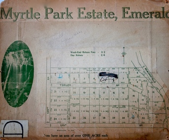
Plan - Subdivision Plan, Myrtle Park Estate, Emerald, 1915
... The subdivision in Emerald included 32 one-acre lots facing Torley Road, Government Road (now Rawhiti and Wong Hee Roads) Beaconsfield Road (now Old Beaconsfield Road). On the plan, an unnamed creek flows through allotments 8-12 on the east side of the Estate. ...The subdivision in Emerald included 32 one-acre lots facing Torley Road, Government Road (now Rawhiti and Wong Hee Roads) Beaconsfield Road (now Old Beaconsfield Road). On the plan, an unnamed creek flows through allotments 8-12 on the east side of the Estate. ...This subdivision plan for the ‘Myrtle Park Estate’ relates to land sales in Emerald, Victoria, rather than to the subdivision of the same name in East Kew (1913-16). The subdivision in Emerald included 32 one-acre lots facing Torley Road, Government Road (now Rawhiti and Wong Hee Roads) Beaconsfield Road (now Old Beaconsfield Road). On the plan, an unnamed creek flows through allotments 8-12 on the east side of the Estate. The photograph of a waterfall and the advertised price of Day Return and Weekend Return Fares provide an indication of who the prospective purchasers were likely to be.subdivision plans - emerald, myrtle park estate, torley road -- emerald (vic.) -
 Emerald Museum & Nobelius Heritage Park
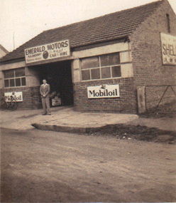
Photograph, Emerald Motors, circa 1930's - 40's
... Kilvington Drive (the Beaconsfield Road) and Main Road. ...Kilvington Drive (the Beaconsfield Road) and Main Road. Early history of the commercial district of Emerald emerald motors herbie sherriff mobiloil signage No inscriptions, but Kodak manufacturing mark on back Small sepia photograph depicting Emerald Motors with (possibly) owner Herbie Sherriff standing out front of business Emerald Motors Photograph Kodak ...Sherriff's Garage started in the Blacksmith's shop (originally Stapletons Blacksmith) , cnr. Kilvington Drive (the Beaconsfield Road) and Main Road. Early history of the commercial district of EmeraldSmall sepia photograph depicting Emerald Motors with (possibly) owner Herbie Sherriff standing out front of businessNo inscriptions, but Kodak manufacturing mark on backemerald motors, herbie sherriff, mobiloil signage -
 MYLI My Community Library
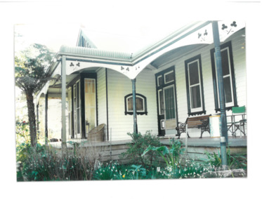
Photograph - Villa Maria exterior verandah, Unknown
... 27 O'Neil Road, Beaconsfield, Cardinia Shire, Victoria, Australia ...Villa Maria, later known as Villa Mar has a close association with the Catholic Church, with identifiable and notable Catholic attributes such as the inner courtyard and chapel on the villa. It also is symbolic of a rural retreat which the Beaconsfield area was once noted for.This house is a symbolic representation of the Federation Bungalow architectural style, with influences of catholic attributes.Colour rectangular photograph developed on matte photographic paper. N/Avilla maria, villa mar, architecture, catholic church, beaconsfield, cardinia shire -
Emerald Museum & Nobelius Heritage Park
Document - Horticultural Catalogue, Staples, Nikki et al, Fast Hedge & Topiary With Traditional Style, 1990s
... The nursery operated at the Beaconsfield Road roundabout, Main Street, Emerald from the 1990s to 2005, closing down after it established a propagation site on Pepi's Land, Beaconsfield Road. ...The nursery operated at the Beaconsfield Road roundabout, Main Street, Emerald from the 1990s to 2005, closing down after it established a propagation site on Pepi's Land, Beaconsfield Road. ...Wombat Gully Nursery (also known as Chris and Marie's Plant Farm) catalogue of hedge and topiary trees offered for sale. The nursery operated at the Beaconsfield Road roundabout, Main Street, Emerald from the 1990s to 2005, closing down after it established a propagation site on Pepi's Land, Beaconsfield Road. There was considerable controversy about its operation in the Main Street due to traffic and other problems (see contemporary newspaper clippings). The catalogue features Boxoz, a form of box-leafed honeysuckle, or Lonicera nitida, propagated by the nursery.Softcover 20 page catalogue with both colour and black and white illustrations and photographs. The front cover features four photographs of gardens, and the back cover is a full-page advertisement.documents, horticulture, sales catalogues, catalogues -
Emerald Museum & Nobelius Heritage Park
Photograph - Joe, Nell & Kevin Teasdale, 1941, 1941
... Photograph of Bill Teasdale with his parents Joe and Nell Teasdale in front of their shop in Beaconsfield Road (now Kilvington Drive). They are located in front of the present-day Emerald Bakery. ...Photograph of Bill Teasdale with his parents Joe and Nell Teasdale in front of their shop in Beaconsfield Road (now Kilvington Drive). They are located in front of the present-day Emerald Bakery. ...The Teasdale family were shop proprietors in the 1940s in Emerald. Kevin Teasdale has written extensively about Emerald in that period. His writings are contained with photographs in his family folder in Filing Cabinet 6C.Black and white rectangular photograph printed on matte photographic paper. Photograph of Bill Teasdale with his parents Joe and Nell Teasdale in front of their shop in Beaconsfield Road (now Kilvington Drive). They are located in front of the present-day Emerald Bakery. The Grady's shop and the Legge's shop are in the background on the present-day site of the Emerald Fruit Shop and other shops to the corner of Heroes Avenue. Year: 1941On back of photo written in biro (presumably by Kevin Teasdale): Joe, Nell and Kevin Teasdale in front of their Beaconsfield Rd (now Kilvington Dve) shop. 1941 Location: where people now drink coffee (in front of the Emerald Bakery of 2012. The Grady's dwelling and Legges' shop are in the background. They have been replaced by today's (2012) fruit shop and other shops to the corner of Heroes Avenue.kevin teasdale, 1940s, joe and nell teasdale, kilvington drive -
Emerald Museum & Nobelius Heritage Park
Document - Holman Family Documents, Ure, Ruth, 2001
... The Holman family moved to Emerald around 1922 and started The Falls guest house on Cardinia Creek along Upper Beaconsfield Road. The covering letter is from Ruth Ure, who wrote the brief family history at the request of Chris Britton. ...The Holman family moved to Emerald around 1922 and started The Falls guest house on Cardinia Creek along Upper Beaconsfield Road. The covering letter is from Ruth Ure, who wrote the brief family history at the request of Chris Britton. ...The Holman family moved to Emerald around 1922 and started The Falls guest house on Cardinia Creek along Upper Beaconsfield Road. The covering letter is from Ruth Ure, who wrote the brief family history at the request of Chris Britton. The news cuttings are extracts of obituaries, marriage notices, etc. See also P307 for three photographs.1 handwritten letter, 1 photocopy of a 2-p. handwritten manuscript, 3 photocopied pages of newsclippings.emerald, victoria, australia, guest houses, genealogy, holman family, the falls guest house, ruth ure, ruth hewlett -
Emerald Museum & Nobelius Heritage Park
Map - Melbourne and surrounds map, Broadbent's Maps et al, Fifty Miles Round Melbourne, 1929
... Slee, both on Emerald-Beaconsfield Road. The map is of interest for showing main roads into Emerald in the 1920s and 1930s, well before construction of Cardinia Reservoir....Slee, both on Emerald-Beaconsfield Road. The map is of interest for showing main roads into Emerald in the 1920s and 1930s, well before construction of Cardinia Reservoir. ...Road map of Melbourne and surrounds showing main tourist areas. Booklet contains information on each area, including Dandenong Ranges. See p. 46 for advertisaements for 'The Falls' guest house (with photograph), owned by Mr and Mrs J.B. Holman, and Nottingham house, owned by M. Slee, both on Emerald-Beaconsfield Road. The map is of interest for showing main roads into Emerald in the 1920s and 1930s, well before construction of Cardinia Reservoir.Folded road map contained in soft cover booklet. 1929-1930 Edition. Includes photographsemerald, victoria, australia, tourism, guest houses, broadbent's maps, royal automobile club of victoria, the falls guest house, nottingham house, j.b. holman, m. slee -
 Emerald Museum & Nobelius Heritage Park
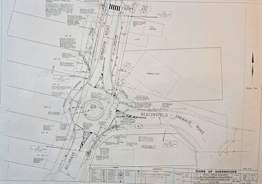
Map - Surveyors Map of new roundabout to be installed at the intersection of Belgrave-Gembrook Rd. and Beaconsfield-Emerald Rd., Emerald 1989, Shire of Sherbrook, Roundabout at intersection of Belgrave-Gembrook Rd., and Beaconsfield-Emerald Rd., Emerald, drawn 1989 - surveyors map, c1989
... Shire of Sherbrooke/Emerald Township roundabouts Belgrave-Gembrook Rd./Beaconsfield-Emerald Road/Monbulk Rd. Intersections/Signed 4/1/89/Legend/Amendments/map...Shire of Sherbrooke/Emerald Township roundabouts Belgrave-Gembrook Rd./Beaconsfield-Emerald Road/Monbulk Rd. Intersections/Signed 4/1/89/Legend/Amendments/map Image of surveyors map outlining dimensions for new roundabout at the intersection of Belgrave-Gembrook Rd., and Beaconsfield-Emerald Rd. 1989 Roundabout at intersection of Belgrave-Gembrook Rd., and Beaconsfield-Emerald Rd., Emerald, drawn 1989 - surveyors map Map Surveyors Map of new roundabout to be installed at the intersection of Belgrave-Gembrook Rd. and Beaconsfield-Emerald Rd., Emerald 1989 Shire of Sherbrook ...Image of surveyors map outlining dimensions for new roundabout at the intersection of Belgrave-Gembrook Rd., and Beaconsfield-Emerald Rd. 1989non-fiction -
Emerald Museum & Nobelius Heritage Park
Functional object - Key to the Emerald Coffee Palace, Unknown maker, 1900s
... This key was the front door key of the Emerald Coffee Palace which was situated on Beaconsfield Road (now Kilvington Drive). Built in 1901. ...This key was the front door key of the Emerald Coffee Palace which was situated on Beaconsfield Road (now Kilvington Drive). Built in 1901. ...This key was the front door key of the Emerald Coffee Palace which was situated on Beaconsfield Road (now Kilvington Drive). Built in 1901. Demolished in 1961. The key was donated by Vera Madigan who was the daughter of T. J. Madigan who demolished the Palace in 1967 to re-develop the site. T. J. Madigan was Emerald's butcher from late 1920s through to the 1940s. The Coffee Palace had accommodation and also had the attraction of being able to serve alcohol.Key. Metal. Leather label inscribed with the key's provenance details attached to key with leather plait. The key dates from 1900s whilst the leather label was added more recently.key, madigan, coffee palace, emerald, victoria, australia, 1900s -
Emerald Museum & Nobelius Heritage Park
Plan - Subdivision Plan
... Commencing 8 chains from Railway Station. Bounded by Beaconsfield Road (old) Shire road, 30th April, 1925. ...Commencing 8 chains from Railway Station. Bounded by Beaconsfield Road (old) Shire road, 30th April, 1925. ...Plan of subdivision of Bay View Estate. T.R.B. Morton and Son, Auctioneers, 80 Swanston Street, Melbourne and Box Hill. Local Agent, T.W. Butcher (1920's). Commencing 8 chains from Railway Station. Bounded by Beaconsfield Road (old) Shire road, 30th April, 1925. Includes description of Emerald Easter Monday 13 April 1925. Terms of Sale Two Pounds deposit, One Pound per month, Interest 6% per annum.Bayview Estate Emerald: Photocopy of original real estate subdivision plan.emerald, victoria, australia, land sales, real estate agencies, maps, bay view estate, t.w. butcher -
 Emerald Museum & Nobelius Heritage Park
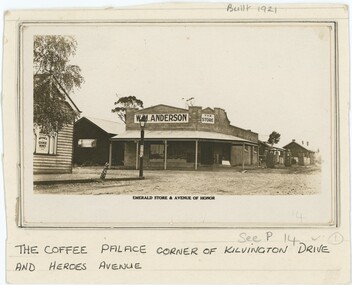
Photograph, Emerald Store & Avenue of Honor, 1920s-1940s
... At the time, these may have respectively been Beaconsfield Road and, according to the label, Avenue of Honor. ...At the time, these may have respectively been Beaconsfield Road and, according to the label, Avenue of Honor. ...This photograph depicts W. M. Anderson's store on the corner of what is now Kilvington Drive and Heroes Avenue. At the time, these may have respectively been Beaconsfield Road and, according to the label, Avenue of Honor. Anderson's store is believed to have been built by the Stillwell family in 1921, but Anderson had his store at least from 1923 and therefore likely owned it from the point of its first construction. By the late 1940s, Anderson's had become Legge's General Store. It is difficult to determine precisely when within that range this photograph was taken, although one local history page attributes it to the earlier end of the range. We believe Anderson's store was on the corner now occupied by Grace and Louie Booksellers.This photograph captures a now-unfamiliar store in a familiar part of old Emerald, documenting the changes to the commercial landscape over the past century.This black and white photograph is attached to a card backing. The backing is annotated in pen below the photograph, describing its location. Other pencil annotation is present on the obverse and reverse of the backing. The photograph shows a store on the street corner, with a porch shading the walkway in front of the building and other shops along the street. On the corner closer top the camera and across from the store is a lamp post, with another shop besides it. On the photograph paper itself is another annotation, this one printed. Obverse: Backing, Top: "Built 1921" Backing, Bottom: "THE COFFEE PALACE CORNER OF KILVINGTON DRIVE / AND HEROES AVENUE" Photograph, Printed Text Below Image: "EMERALD STORE & AVENUE OF HONOR" Photograph, Sign in Left of Image: "IRVINE'S / CHOICE WINES" Photograph, Sign in Centre-Left of Image: "W. M. ANDERSON" Photograph, Sign in Centre of Image: "THE / STORE" Reverse: "Built in 1921 By Stillwell. / Andersons Store - later Legge's"emerald, 1920s, 1930s, commerce -
 Emerald Museum & Nobelius Heritage Park
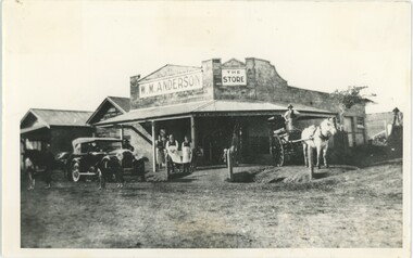
Photograph - W. M. Anderson Store, 1920s-40s
... At the time, these may have respectively been Beaconsfield Road and, according to the label, Avenue of Honor. ...At the time, these may have respectively been Beaconsfield Road and, according to the label, Avenue of Honor. ...This photograph depicts W. M. Anderson's store on the corner of what is now Kilvington Drive and Heroes Avenue. At the time, these may have respectively been Beaconsfield Road and, according to the label, Avenue of Honor. Anderson's store is believed to have been built by the Stillwell family in 1921, but Anderson had his store at least from 1923 and therefore likely owned it from the point of its first construction. By the late 1940s, Anderson's had become Legge's General Store. It is difficult to determine precisely when within that range this photograph was taken. We believe Anderson's store was on the corner now occupied by Grace and Louie Booksellers. Some of the people in the photograph include Bill Anderson with Albert Legge, and Leo Hirst - employees of Anderson - in the center-left, and George Davey standing in the cart.This photograph captures a now-unfamiliar store in a familiar part of old Emerald, documenting the changes to the commercial landscape over the past century.This black and white photograph depicts a store on a street corner, with a porch covering the walkway outside and several signs on the building, along with writing on the end of the porch covering. In the left of the frame is a car, with two dogs, a horse, and a man surrounding it; in the right, a man strands on a horsecart drawn by a white horse. In the center-left are three men wearing aprons with a child besides them, while in the center a woman and child stand in the doorway. In the background, other buildings continue down both streets. The reverse is annotated, and has six rectangular artefacts where adhesive was once applied. A section of handwriting is illegible due to damage, but likely read 'Heroes Avenue' or 'Avenue of Honour'.Reverse: "Built in 1921 / Cr [illegible] & Kilvington / Cross reference 56" Obverse: In Photograph Sign, Left: "W. M. ANDERSON" In Photograph Sign, Right: "THE / STORE" In Photograph, Porch: "W.M.ANDERSON [illegible]"emerald, commerce, 1920s, 1930s, 1940s -
 Emerald Museum & Nobelius Heritage Park
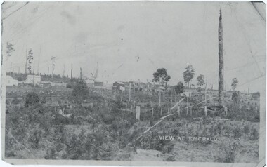
Photograph, View at Emerald, 1898
... Notes associated with this photograph indicate both that it was taken at the end of Heroes Avenue and that it was taken on 'Monbulk Road' - while these notes might simply be incorrect, it may also indicate that this may have been taken at what is now the intersection of Heroes Avenue and either Beaconsfield-Emerald Road or Kilvington Drive, potentially at the time under a different or incorrect name. ...Notes associated with this photograph indicate both that it was taken at the end of Heroes Avenue and that it was taken on 'Monbulk Road' - while these notes might simply be incorrect, it may also indicate that this may have been taken at what is now the intersection of Heroes Avenue and either Beaconsfield-Emerald Road or Kilvington Drive, potentially at the time under a different or incorrect name. ...Notes associated with this photograph indicate both that it was taken at the end of Heroes Avenue and that it was taken on 'Monbulk Road' - while these notes might simply be incorrect, it may also indicate that this may have been taken at what is now the intersection of Heroes Avenue and either Beaconsfield-Emerald Road or Kilvington Drive, potentially at the time under a different or incorrect name. This photograph was taken in 1898 when Emerald was much less densely occupied as a growing town amidst Nobelius' nursery.This photograph captures a side of Emerald that no longer exists, looking at the growing town from an outside that has long since been encompassed by the town.A black and white photograph of a landscape, with various buildings in the background and the road in the foreground. The photograph is quite small, which means scans of it are at quite a low resolution. There are several markings and copies of fold marks preserved from the original.Label: "VIEW AT EMERALD" Later note, rear of copy: "Heroes Ave end. 1898."emerald, 1890s -
 Emerald Museum & Nobelius Heritage Park
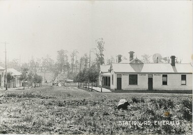
Photograph, Station Rd, Emerald, c. 1907
... This c. 1907 photograph was taken from the intersection of Beaconsfield Road (now Kilvington Drive) and Station Road (now Puffing Billy Place), looking towards Emerald Railway Station. ...This c. 1907 photograph was taken from the intersection of Beaconsfield Road (now Kilvington Drive) and Station Road (now Puffing Billy Place), looking towards Emerald Railway Station. ...There are seven other copies of this photograph in our collection, mostly differing in the placement of the label and the cropping of the photograph. This is itself a copy of the original. One of these copies is also accessioned as VEMUP0456.2. This c. 1907 photograph was taken from the intersection of Beaconsfield Road (now Kilvington Drive) and Station Road (now Puffing Billy Place), looking towards Emerald Railway Station. It looks past the Emerald Coffee Palace, a significant establishment serving coffee, wine, and more - a room in the back was even used as a visiting doctor's surgery. The Coffee Palace was, at the time, owned by the O'Connor family and run by Mrs Greatorex. At this time it was relatively new - the second centre of Emerald, around Kilvington Drive, mostly materialised thanks to the location of the railway station. The location of the railway is visible, but from this angle the station and tracks are not visible. Note the posts in front of the Palace - used to tie horses in this time before cars became dominant. There are elevated wires visible running along the left side of the street, which resemble power lines but at this time are more likely to have instead been telegraph cables. This copy was framed in the donor's home after being gifted to him by its previous owner, who bought it from an op-shop in Melbourne.This photograph recounts the growth of Emerald's second town centre around the railway station.This item is a large, slightly yellowed, black and white copy of an older photograph. It depicts an unpaved street leading down a hill to a gate and fence, with several shops to either side. There is a lamp post on the street corner on the right, and a telegraph line running along the left side. In the background, the slope rises back up to a hill with fields and scattered trees.Bottom-right: "STATION RD. EMERALD" Building in the photograph: "EMERALD COFFEE PALACE"emerald coffee palace, emerald, 1900s, commerce -
 Emerald Museum & Nobelius Heritage Park
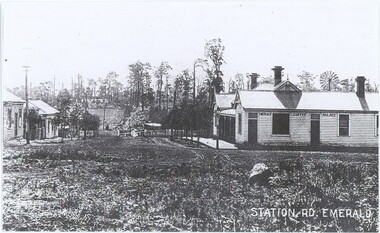
Photograph, Station Rd, Emerald, c. 1907
... This c. 1907 photograph was taken from the intersection of Beaconsfield Road (now Kilvington Drive) and Station Road (now Puffing Billy Place), looking towards Emerald Railway Station. ...This c. 1907 photograph was taken from the intersection of Beaconsfield Road (now Kilvington Drive) and Station Road (now Puffing Billy Place), looking towards Emerald Railway Station. ...There are seven other copies of this photograph in our collection, mostly differing in the placement of the label and the cropping of the photograph. This is itself a copy of the original. One of these copies is also accessioned as VEMUP0456.2. This c. 1907 photograph was taken from the intersection of Beaconsfield Road (now Kilvington Drive) and Station Road (now Puffing Billy Place), looking towards Emerald Railway Station. It looks past the Emerald Coffee Palace, a significant establishment serving coffee, wine, and more - a room in the back was even used as a visiting doctor's surgery. The Coffee Palace was, at the time, owned by the O'Connor family and run by Mrs Greatorex. At this time it was relatively new - the second centre of Emerald, around Kilvington Drive, mostly materialised thanks to the location of the railway station. The location of the railway is visible, but from this angle the station and tracks are not visible. While the annotation lists that the photograph was taken in 1889, the visibility of a gate (contra the annotation) and existence of this second town centre - which grew around the station - suggests that other sources lisitng 1907 are closer to accuracy. Note the posts in front of the Palace - used to tie horses in this time before cars became dominant. There are elevated wires visible running along the left side of the street, which resemble power lines but at this time are more likely to have instead been telegraph cables.This photograph recounts the growth of Emerald's second town centre around the railway station.This item is a black and white copy of an older photograph. It depicts an unpaved street leading down a hill to a gate and fence, with several shops to either side. There is a lamp post on the street corner on the right, and a telegraph line running along the left side. In the background, the slope rises back up to a hill with fields and scattered trees.Bottom-right: "STATION RD. EMERALD" Building in the photograph: "EMERALD COFFEE PALACE" Reverse: "Coffee Palace was guest house / Note no gates this was before the railway Puffing Billy came through. / Note posts to tie horses to outside the palace. / O'Connors owned Coffee Palace. / Windmill in back of Palace - bore for water. 1889."emerald coffee palace, emerald, commerce, 1900s -
 Flagstaff Hill Maritime Museum and Village
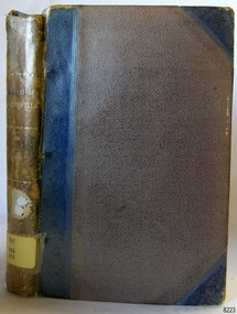
Book - Papers and Addresses, Benjamin Disraeli, Wit and Wisdom of Benjamin Disraeli, Earl of Beaconsfield: collected from his writings and speeches, 1886
... Road...Shipwreck Coast...Pattison Collection...Ralph Eric Pattison...Warrnambool Mechanics’ Institute...Mechanics’ Institute Library...Warrnambool Library...Free Library...Corangamite Regional Library Service...Longmans Green and Co. London...Wit and Wisdom...Benjamin Disraeli...Queen Victoria's friend...Longmans Green & Co...Speeches...Addresses...writings...Papers...Earl of Beaconsfield...Flagstaff Hill Flagstaff Hill Maritime Museum and Village Warrnambool Maritime Museum Maritime Village Great Ocean Road Shipwreck Coast Pattison Collection Ralph Eric Pattison Warrnambool Mechanics’ Institute Mechanics’ Institute Library Warrnambool Library Free Library Corangamite Regional Library Service Longmans Green and Co. London Wit and Wisdom Benjamin Disraeli Queen Victoria's friend Longmans Green & Co Speeches Addresses writings Papers Earl of Beaconsfield British politician British Prime Minister Label on spine: "PAT 824 DIS" Sticker on pastedown front endpaper: "Warrnambool Mechanics Institute and Free Library" covered by a sticker "Corangamite Regional Library Service" Stamp on front loose endpaper: "Corangamite Regional Library Service" Handwritten on fly: "N" "257 (crossed out)" "8" "G 328 (crossed out)" "4" "265" Wit and Wisdom of Benjamin Disraeli, Earl of Beaconsfield: collected from his writings and speeches Author: Benjamin Disraeli Publisher: Longmans Green and Co Date: 1886 (new edition, first printed in 1881) Brown cloth hardcover book with blue reinforcing on spine and corners. ...Benjamin Disraeli (1801-1881) was a politician, who wrote novels, was the prime minister (twice) of the United Kingdom, and was the only Jewish-born Prime Minister. He became a close friend to Queen Victoria, who entitled him to 1st Earl of Beaconsfield. The book is part of Flagstaff Hill's Pattison Collection, a large group of books and records, some of which are rare and valuable. The collection was originally owned by the Warrnambool Mechanics' Institute, which was founded in 1853 and is named after Warrnambool's Public Librarian, Ralph Pattison. The publisher firm Longmans, Green & Co. was founded in 1724 in London by Thomas Longman under the name Longman. In August of that year, he bought the two shops and goods of William Taylor and set up his publishing house there at 39 Paternoster Row. The shops were called Black Swan and Ship, and it is said that the 'ship' sign was the inspiration for Longman's Logo. After many changes of name and management, the firm was incorporated in 1926 as Longmans, Green & Co. Pty Ltd. The firm was acquired by Pearson in 1968 and was known as Pearson Longman or Pearson PLC. This collection of papers and speeches of politician Benjamin Disraeli is significant as a window into the political background of the Victorian era. The book is important for its connection with the London publisher Longmans, Green & Co. The firm has been established for over two centuries and is renowned for publishing encyclopedias, dictionaries, books on English grammar, textbooks, poetry, reference books, novels, magazines and more. The book has additional importance for its connection to the Pattison Collection, which, along with other items at Flagstaff Hill Maritime Village, was originally part of the Warrnambool Mechanics' Institutes’ Collection. The Warrnambool Mechanics’ Institute book collection has historical and social significance for its strong association with the Mechanics Institute movement and its important role in people's intellectual, cultural and social development throughout the latter part of the nineteenth century and the early twentieth century. The collection of books is a rare example of an early lending library and its significance is enhanced by the survival of an original collection of many volumes. The Warrnambool Mechanics' Institute’s publication collection is of both local and state significance.Wit and Wisdom of Benjamin Disraeli, Earl of Beaconsfield: collected from his writings and speeches Author: Benjamin Disraeli Publisher: Longmans Green and Co Date: 1886 (new edition, first printed in 1881) Brown cloth hardcover book with blue reinforcing on spine and corners. Inscriptions are on stickers, a label, a stamp, and handwritten on the fly page. The book is part of the Pattison Collection.Label on spine: "PAT 824 DIS" Sticker on pastedown front endpaper: "Warrnambool Mechanics Institute and Free Library" covered by a sticker "Corangamite Regional Library Service" Stamp on front loose endpaper: "Corangamite Regional Library Service" Handwritten on fly: "N" "257 (crossed out)" "8" "G 328 (crossed out)" "4" "265"flagstaff hill, flagstaff hill maritime museum and village, warrnambool, maritime museum, maritime village, great ocean road, shipwreck coast, pattison collection, ralph eric pattison, warrnambool mechanics’ institute, mechanics’ institute library, warrnambool library, free library, corangamite regional library service, longmans green and co. london, wit and wisdom, benjamin disraeli, queen victoria's friend, longmans green & co, speeches, addresses, writings, papers, earl of beaconsfield, british politician, british prime minister
