Showing 41 items matching "brown river road"
-
 Ballarat Heritage Services
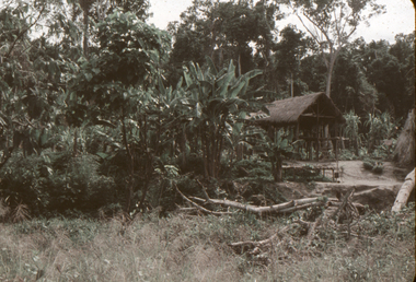
Slide, Dorothy Wickham, Hut, Brown River Road, Papua New Guinea, 1958
... Hut, Brown River Road, Papua New Guinea......Brown River Road...Ballarat Heritage Services PO Box 2209 Bakery Hill Post Office goldfields papua new guinea papuan Brown River Road Hut thatch View from this side Scanned from a coloured slide Hut, Brown River Road, Papua New Guinea Slide Dorothy Wickham ...Scanned from a coloured slideView from this sidepapua new guinea, papuan, brown river road, hut, thatch -
 Bendigo Historical Society Inc.
Postcard - Elliot Postcard Collection: Australia, 1895 - 1914
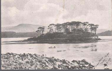
... Tasmania 1405.265 Hobart 1405.266 Restless Seas, Coast of Australia 1405.267 Brown's River Road 1405.268 The Rocking Stone, Mt. ...Tasmania 1405.265 Hobart 1405.266 Restless Seas, Coast of Australia 1405.267 Brown's River Road 1405.268 The Rocking Stone, Mt. ...Thought to have originated in Austria in 1869, postcards first gained popularity in Australia in the 1890s.They were used to send short messages to friends and family. This collection was generated by Mary Emma Elliot of Talgarno. Talgarno is a rural locality in Victoria, Australia, situated on the southern shoreline of Lake Hume, about 23 km east of Albury-Wodonga. The collection contains postcards from across the world. Mary Emma Sibley was born in Ironbark, Bendigo in 1859. She married James Elliot in 1893 and they settled at “Kelso”, Talgarno. They had two children – Mona and Sibley. Mary Emma Elliot died in Melbourne in 1944, aged 84 years. Australian postcards collected by Mrs. James Elliot between 1898 and 1915. 1405.261 Port Arthur, Dead Island No 1 1405.262 Launceston, Crusoe Hut, Cataract Gorge 1405.263 Kathleen Sound, Gordon River, W. Coast. Tasmania 1405.264 St. Patrick's Head. East Coast. Tasmania 1405.265 Hobart 1405.266 Restless Seas, Coast of Australia 1405.267 Brown's River Road 1405.268 The Rocking Stone, Mt. Wellington 1405.269 Cataract Gorge, Launceston. Tas 1405.270 Mount Olympus. Tasmania 1405.271 Latrobe Road near Devonport 1405.272 Salmon Ponds, New Norfolk 1405.273 Launceston from Trevallyn 1405.274 Burnie, N. W. Coast. Tasmania 1405.275 River Derwent, near New Norfolk 1405.276 Botanic Gardens, Hobart, Tasmania 1405.277 "The Winter Garden" 1405.278 Hobart Waterworks 1405.279 LAUNCESTON. King's Bridge 1405.280 The Bridge. Perth (Tasmania)postcards, collecting, collections, talgarno -
 Bendigo Historical Society Inc.
Postcard - Elliot Postcard Collection: Australia, 1895 - 1914
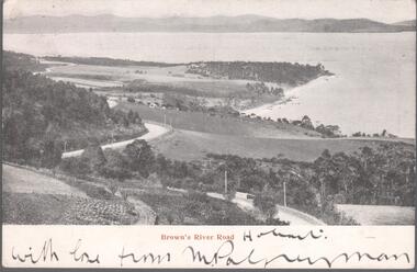
... James Elliot between 1898 and 1915. 1405.281 Brown's River Road (Copy No 2) 1405.282 New Norfolk 1405.283 Road Scene near Weldborough, N. ...James Elliot between 1898 and 1915. 1405.281 Brown's River Road (Copy No 2) 1405.282 New Norfolk 1405.283 Road Scene near Weldborough, N. ...Thought to have originated in Austria in 1869, postcards first gained popularity in Australia in the 1890s.They were used to send short messages to friends and family. This collection was generated by Mary Emma Elliot of Talgarno. Talgarno is a rural locality in Victoria, Australia, situated on the southern shoreline of Lake Hume, about 23 km east of Albury-Wodonga. The collection contains postcards from across the world. Mary Emma Sibley was born in Ironbark, Bendigo in 1859. She married James Elliot in 1893 and they settled at “Kelso”, Talgarno. They had two children – Mona and Sibley. Mary Emma Elliot died in Melbourne in 1944, aged 84 years. Australian postcards collected by Mrs. James Elliot between 1898 and 1915. 1405.281 Brown's River Road (Copy No 2) 1405.282 New Norfolk 1405.283 Road Scene near Weldborough, N. E. Coast, Tasmania 1405.284 West Burnie. Tasmania 1405.285 General Post Office, Hobart 1405.286 Above the Rapids, Gordon River, Tasmania 1405.287 St. Patrick's River and Fisherman's Hut. Tasmania 1405.288 Cataract Gorge 1405.289 Cataract Gorge, Launceston 1405.290 Silver Falls, Mt. Wellington, Tasmania 1405.291 A Famous Tourists Resort. Mount Roland and Mount Claude near Sheffield. Tas 1405.292 Picturesque Tasmania 1405.293 Fem Scene - Lobster Creek - near Ulverstone. Tas 1405.294 St. Mary's Pass. East Coast. Tasmania 1405.295 Huonville. Tasmania 1405.296 Russell Falls 1405.297 Government House, Hobart 1405.298 Christ Church, Longford, Tasmania 1405.299 Port Arthur 1405.300 Launceston. Pulpit Rock, Corra Linnpostcards, collecting, collections, talgarno -
 Warrnambool and District Historical Society Inc.
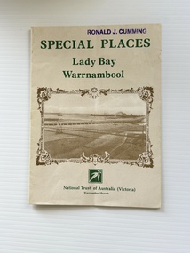
Pamphlet - Special Places Lady Bay Warrnambool, Philprint Warrnambool, 1989
... There is a brown sepia photograph showing a view across Lady Bay with the suspension bridge across the Merri River in the foreground, Viaduct Road in the middle ground and the breakwater in the background. ...There is a brown sepia photograph showing a view across Lady Bay with the suspension bridge across the Merri River in the foreground, Viaduct Road in the middle ground and the breakwater in the background. ...This pamphlet was produced for the Warrnambool Branch of the National Trust of Australia (Victoria) for Heritage Week, April 16-23, 1989 and contains information written by Warrnambool residents about their locality. This was a co-operative venture by people with a common interest in protecting the natural environment near their home. Areas covered in the written information include: Formation of the Coast, Archaeological survey, Gunditjmara History, vegetation, history and recreational uses of the Lady Bay area. The map shows special places of interest including past and present navigational aids, sites of shipwrecks and other historical places of interest. The Warrnambool Branch of the National Trust was originally formed in March 1969 and merged with the Port Fairy Branch in late 1970. In October 1979, the Warrnambool Branch was reformed and operated into the late 1990's. This is an example of a publication produced by the Warrnambool Branch of the National Trust Australia (Victoria). It provides historical information and perspectives of the recreational uses in and around Lady Bay Warrnambool.An A2 piece of buff coloured thick paper folded into eight to make an A5 pamphlet. The front cover has green printing with the National Trust symbol of three eucalyptus leaves in green. There is a brown sepia photograph showing a view across Lady Bay with the suspension bridge across the Merri River in the foreground, Viaduct Road in the middle ground and the breakwater in the background. There is a purple inked stamp on the top right hand corner. The rear cover has brown writing and includes logos of bodies who assisted with the publication. There is a brown line drawing of the viaduct and pier at the Warrnambool Breakwater. The inside of the unfolded pamphlet contains a map of Lady Bay and adjacent area showing places of interest and shipwrecks marked in red circlesFront cover: Special Places Lady Bay Warrnambool National Trust of Australia (Victoria) Warrnambool Branch Ronald J. Cummingwarrnambool, lady bay warrnambool, national trust australia victoria warrnambool branch, heritage week 1989, lady bay shipwrecks -
 Warrnambool and District Historical Society Inc.
Map - Fire Maps, Region 5 Fire Control Map, 1963
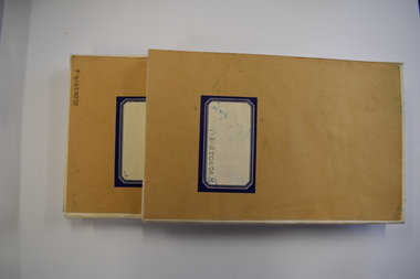
... roads, the swamps and creeks, rivers, railways, mountains and towns. These maps were produced in 1963 so are today of historical interest and they would be useful research tools. Fire Maps Warrnambool History Two fire maps of south west Victoria .1 This is a rectangular piece of linen folded several times to form a packet with the front part covered with a brown card. ...Two fire maps of south west Victoria.1 This is a rectangular piece of linen folded several times to form a packet with the front part covered with a brown card. The cover has a blue and white label. The map has a white base with red and green markings and red and black printing .2 As .1 abovenon-fictionTwo fire maps of south west Victoriafire maps, warrnambool history -
 Kiewa Valley Historical Society
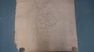
Map - Bogong High Plains
... Kiewa Valley Historical Society Mount Beauty Information Centre 31 Bogong High Plains Rd Mt Beauty high-country Bogong high Plains showing mountains, places, roads and rivers Historical changes of infrastructure on the Bogong High Plains bogong high plains map Bogong High Plains, hand written and 'copied with considerable simplification from F.C.V. (Falls Creek V.?) 'Feathetop' L 'Tawonga'. Paper is yellowed, writing is brown ...Bogong high Plains showing mountains, places, roads and riversHistorical changes of infrastructure on the Bogong High PlainsBogong High Plains, hand written and 'copied with considerable simplification from F.C.V. (Falls Creek V.?) 'Feathetop' L 'Tawonga'. Paper is yellowed, writing is brown.bogong high plains map -
 Kiewa Valley Historical Society
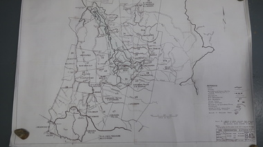
Map - Bogong High Plains - Grazing Runs, Grazing Run Boundaries 1960 - Soil Conservation Authority
... brown print. Bogong High Plains from Feathertop in the west to Mt Nelse in the east showing physical boundaries including the Kiewa Hydro Electric Scheme, roads, rivers and mountains. ...brown print. Bogong High Plains from Feathertop in the west to Mt Nelse in the east showing physical boundaries including the Kiewa Hydro Electric Scheme, roads, rivers and mountains. ...Cattle grazing on the Bogong High Plains during summer commenced in the 1840s and continued for many years. The Soil Conservation Authority recorded each family's area boundaries which were updated in June 1972 and continued to be adjusted until cattle were banned in 2005. The tradition of cattle grazing continues to be controversial.Holders of grazing rights for grazing on the Bogong High Plains were allocated specific areas recorded by the Soil Conservation Authority in 1972. Cattle have been banned in the Alpine National Park due to their impact on the environment.White paper with brown print. Bogong High Plains from Feathertop in the west to Mt Nelse in the east showing physical boundaries including the Kiewa Hydro Electric Scheme, roads, rivers and mountains. Names of families with grazing runs and the boundaries are shown.cattlemen, grazing runs, bogong high plains, kiewa valley families -
 Kiewa Valley Historical Society
Map - Kiewa Scheme General Plan
... rivers, roads and SECV places are named, also SECV infrastructure and construction eg. workers camps, Power stations. Significant for the information re the Kiewa Hydro Electric Scheme's development. bob duncan kiewa hydro electric scheme secv khes development Handwritten: 'Bob Duncan' Yellowed paper with brown print. ...Existing and possible future roads are numbered and named 1 - 45. The plan is based on an aerial photos taken March 1945. It includes revisions up to 1951. Signed by H.H.C. Williams, construction engineer. Mountains, rivers, roads and SECV places are named, also SECV infrastructure and construction eg. workers camps, Power stations.Significant for the information re the Kiewa Hydro Electric Scheme's development.Yellowed paper with brown print. Kiewa Scheme general plan showing its development. A lot of information is recorded. Note: Dyeline print was used which causes fading when exposed to light. Handwritten: 'Bob Duncan'bob duncan, kiewa hydro electric scheme, secv, khes development -
 Orbost & District Historical Society
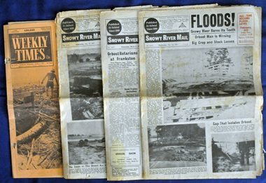
newspapers, February, March 1971
... brown floodwater stain in Bass Strait could be seen from passing airliners." Considerable damage was done to railway infrastructure, roads and farms. More information from the APRIL, 2008 newsletter by John Phillips. (see orbosthistory.com.au) These newspapers are contemporary records of a significant local event. floods-orbost-1971 snowy-river ...The 1971 flood was the the worst flood on record. At Jarrahmond it was at least 11 metres and up to one and a half kilometres wide on the flats causing enormous damage to the flood plain. Records say that "The brown floodwater stain in Bass Strait could be seen from passing airliners." Considerable damage was done to railway infrastructure, roads and farms. More information from the APRIL, 2008 newsletter by John Phillips. (see orbosthistory.com.au) These newspapers are contemporary records of a significant local event.Four newspapers relating to the floods in 1971. They contain news articles and photographs of the floods in Orbost in early 1971. 2556.1 is the Weekly Times dated 3.3.1971 and has an orange cover. 2556.2 is a Snowy River Mail dated 17.2.1971. 2556.3 is a Snowy River Mail dated 10.2.1971. 2556.4 is a Snowy River Mail dated 3.3.1971.floods-orbost-1971 snowy-river-mail weekly-times newspapers -
 Eltham District Historical Society Inc
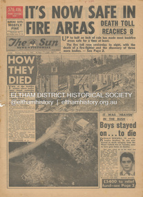
Newspaper - Newspaper articles, Sun News-Pictorial, It's Now Safe in Fire Areas; Death Toll Reacxhes 8, The Sun News-Pictorial, Thursday, January 18, p1, 1962
... Brown...Harold Vernon Betton...Bloom Road...William Smith...Olinda...Bushfire Relief Fund...Yarra Glen...Healesville...Railway Line...St. Andrews...Smith’s Gully...Otway Ranges...Eric Watts...Edith Varty...Inverness Road...Mt. Evelyn...Wye River...River, p9 (Illust.) • “Probe Fires” – Stoneham, p9 • The Fourth Day: Scorched Earth!, pp22-23 (Illust.) • This home was saved but - , p22 (Illust.) • Relief Centre, p23 (Illust.) • Homeless, p23 (Illust.) • So little was left, p43 (Illust.) • Tommy saved his cat, p43 (Illust.) • Some were lucky … and some were tired, p44 (Illust.) Tom Fielding Collection Victorian Bushfires - 1962 Victorian Bushfires – 1962 Ronald Ockwell Geoffrey Ockwell Woori Yallock William Ockwell Leslie Ockwell Linda May Ockwell Black Friday Victorian Bushfires – 1939 Warrandyte Arthur Brown Harold Vernon Betton Bloom Road William Smith Olinda Bushfire Relief Fund Yarra Glen Healesville Railway Line St. ...Various news articles pertaining to the January 1962 Victorian bushfires in the Dandenong and Healesville districts which by the third day had encompassed large areas of the State. Specific Eltham Shire districts mentioned include Warrandyte on page 1, St. Andrews and Smith’s Gully on page 2, St. Andrews on page 3 and 43, Panton Hill and Warrandyte on p23 and Hurstbridge on page 44 • It's Now Safe in Fire Areas; Death Toll Reaches 8, p1 (Illust.) • How they died, pp1-2 • It was “heaven” in the bush … Boys stayed on . . . to die, pp1-2 (Illust.) • Towns take stock as danger drops, p2 • £5400 to the relief fund, p2 • Fire now threat to Otways, p2 • Pensioners lose all, p2 • “…If Only The Rain Had Come” … and then it came to town, p3 (Illust.) • Our best rain since May • It halted at Grandma’s front gate, p5 (Illust.) • Now that the rain has come; It’s time for the clean-up, p6 • Wisps of smoke where flames danced, p7 • Charitry’s a loser, p7 • War Service homes claim, p7 • Help’s on way, p7 (Illust.) • Came with their gifts …, p7 • Fire summons for youth; “sparked the rest”, p9 • Three gaoled, p9 • They had to camp out at Wye River, p9 (Illust.) • “Probe Fires” – Stoneham, p9 • The Fourth Day: Scorched Earth!, pp22-23 (Illust.) • This home was saved but - , p22 (Illust.) • Relief Centre, p23 (Illust.) • Homeless, p23 (Illust.) • So little was left, p43 (Illust.) • Tommy saved his cat, p43 (Illust.) • Some were lucky … and some were tired, p44 (Illust.) tom fielding collection, victorian bushfires - 1962, victorian bushfires – 1962, ronald ockwell, geoffrey ockwell, woori yallock, william ockwell, leslie ockwell, linda may ockwell, black friday, victorian bushfires – 1939, warrandyte, arthur brown, harold vernon betton, bloom road, william smith, olinda, bushfire relief fund, yarra glen, healesville, railway line, st. andrews, smith’s gully, otway ranges, eric watts, edith varty, inverness road, mt. evelyn, wye river, panton hil, heather sullivan, warrandyte hall, montrose, kalorama, mrs e. tucker, shirley tucker, margaret tucker, joane tucker, roger tucker, trevor tucker, ann quinton, tom dunstan, hurstbridge hall -
 Eltham District Historical Society Inc
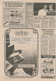
Document - Folder, Eltham Banner Project, 1986
... Brown...DOoncal Air Coinditioning and Central Heating...Eltham Festival...Eltham Outdoor Art Show...Eltham Peace Banner...Eltham Town Park...Grand Parade...Pauline Therese Toner...Peter Wilson...Research Shops...River of Life Banner...Shire of Eltham Acquisitive Award...Valley Carpets...16 Sherbourne Road...Banners fly high at lastt, Diamond Valley News, Tuesday, October 21, 1986, p17 Also various advertisements from businesses within the shire As We Are Banner Project Eltham Banners Meruka House Sarah Houseman Advertising Eagle Screens & Blinds 1986 Alistair Knox Park Bob Manuell Don Brown DOoncal Air Coinditioning and Central Heating Eltham Festival Eltham Outdoor Art Show Eltham Peace Banner Eltham Town Park Grand Parade Pauline Therese Toner Peter Wilson Research Shops River of Life Banner Shire of Eltham Acquisitive Award Valley Carpets 16 Sherbourne Road Briar Hill 22 Were Street Montmorency 1177-1181 Main Road Eltham Barry Reading Goumet Butchers Eltham Hardware & Plumbing Supplies Pty Ltd Hutchinsons Garden Supplies 38 Bridge Street Eltham Artists Costless Clearance Centre Cr Bob Manuell Jud Duigan Margaret Cherry Tracey Naughton Woolworths Arcade Anthea Morrison Beyond the end of the line Diamond Valley Musical Society Eltham College Eltham Community Festival Eltham High School Eltham Service Club Geraldine Veerman Ian Robertson 19 Were Street Montmorency Arnold Thomas Arnolds Recycling Centre Kevin McNamara Luck Street Eltham McEwans Montmorency Hardware Peel Street Eltham Tim Payze 1022 Main Road Eltham As We Are Banner Exhibition Jud Degan Marg Cherry The Cut Ahead Arthur Street Eltham Mall Flexiteller National Australia Bank Newspaper clippings Eltham Banner Project Document Folder ...Newspaper articles about the As We Are Eltham Banner Project undertaken within the Shire of Eltham 1. Eltham banner to celebrate environment, Diamond Valley News, Tuesday, September 16, 1986, p16 2. Group paints for peace, Diamond Valley News, Tuesday, September 30, 1986, p2 3. Banners show people of Eltham as they are, Diamond Valley News, Tuesday, October 14, 1986, pp12-13 4. Banners fly high at lastt, Diamond Valley News, Tuesday, October 21, 1986, p17 Also various advertisements from businesses within the shire Newspaper clippingsas we are, banner project, eltham banners, meruka house, sarah houseman, advertising, eagle screens & blinds, 1986, alistair knox park, bob manuell, don brown, dooncal air coinditioning and central heating, eltham festival, eltham outdoor art show, eltham peace banner, eltham town park, grand parade, pauline therese toner, peter wilson, research shops, river of life banner, shire of eltham acquisitive award, valley carpets, 16 sherbourne road briar hill, 22 were street montmorency, 1177-1181 main road eltham, barry reading goumet butchers, eltham hardware & plumbing supplies pty ltd, hutchinsons garden supplies, 38 bridge street eltham, artists, costless clearance centre, cr bob manuell, jud duigan, margaret cherry, tracey naughton, woolworths arcade, anthea morrison, beyond the end of the line, diamond valley musical society, eltham college, eltham community festival, eltham high school, eltham service club, geraldine veerman, ian robertson, 19 were street montmorency, arnold thomas, arnolds recycling centre, kevin mcnamara, luck street eltham, mcewans, montmorency hardware, peel street eltham, tim payze, 1022 main road eltham, as we are banner exhibition, jud degan, marg cherry, the cut ahead, arthur street, eltham mall, flexiteller, national australia bank -
 Greensborough Historical Society
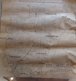
Map, City of Heidelberg. Engineers Dept, City of Heidelberg, 1960s
... Greensborough Historical Society 34A Glenauburn Road Lower Plenty Lower Plenty melbourne Map of the City of Heidelberg from the Yarra River in the South to North of Watsonia Military Camp. Shire of Diamond Valley is shown to the north. city of heidelberg "Scale: 20 CHS = to 1 IN" Map showing municipal and ward boundaries, black text on light brown paper. ...Map of the City of Heidelberg from the Yarra River in the South to North of Watsonia Military Camp. Shire of Diamond Valley is shown to the north.Map showing municipal and ward boundaries, black text on light brown paper."Scale: 20 CHS = to 1 IN"city of heidelberg -
 Eltham District Historical Society Inc
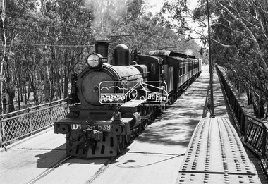
Photograph, VR Commissioner's Special train, steam locomotive D3-639 crossing the Echuca-Moama Road Rail Bridge over the Murray River from Moama, NSW to Echuca, Victoria, 1962
... Brown on Footplate. George C.L. Coop c1963". https://victoriancollections.net.au/items/59d575b921ea6e1278d78042 However based on frame no. 10, date set as 1962 D3-639 D3-Class Steam Locomotive Echuca-Moama Road Rail Bridge Edgar Henry Brownbill George Coop Collection Murray River VR Commissioner's Special Train Digital TIFF file Scan of 35mm Ilford FP3 black and white negative transparency VR Commissioner's Special train, steam locomotive D3-639 crossing the Echuca-Moama Road Rail Bridge over the Murray River from Moama, NSW to Echuca, Victoria. ...VR Commissioner's Special train, steam locomotive D3-639 crossing the Echuca-Moama Road Rail Bridge over the Murray River from Moama, NSW to Echuca, Victoria. Commissioner Edgar Henry Brownbill on footplate, 1962. Commissioner Edgar Henry Brownbill was in office 1957 to 1967. George Coop advises - "The train on the Eltham/Moama bridge is actually the Commissioner’s Special on one of its inspection tours of the VR rail system. This was a very grand special train with accommodation for the Commissioner and staff in carriages also used once for the Royal Train and other State purposes. You can just see the Commissioner of the day, dressed in his suit and wearing engine drivers gloves, standing in the loco cab doorway. A good ‘hands on’ impression is created amongst local staff if can be seen that the boss is no ‘desk jockjey’. The observation car on the back was originally made for the ’Spirit of Progress’. I climbed up onto the bridge iron plate work to get this view. It was safe enough as the cantilevered pedestrian walkway was still on the east side at the time." "I was resident in Echuca from Jan. ’59 to approx. May ’64. At that time the single Echuca/Moama bridge was a combined road/rail bridge. The rail gauge was 5’3” and still is, I believe, on the new bridge that sits just upstream of the old one. This rail line into NSW has always been 5’3" gauge because it has no connection with any NSW tracks. The old Echuca/Moama bridge, locally called the ‘Iron Bridge’ has, over years, undergone some structural changes. The two lattice iron hoops arcing over the roadway have been raised and lowered and changed design. Presently a pedestrian walkway is cantilevered off the west (or downstream) side of the bridge. It used to be on the eastern side. Guess changes went in when new rail bridge only was built on the eastern side as well." Image dated as c.1963 based on same image in Port of Echuca collection (possibly frame 32 of film) (print 19.5 x 24.5cm) On reverse in pencil: "Brown card" in black pen: "Commissioners special. F. Brown on Footplate. George C.L. Coop c1963". https://victoriancollections.net.au/items/59d575b921ea6e1278d78042 However based on frame no. 10, date set as 1962Digital TIFF file Scan of 35mm Ilford FP3 black and white negative transparencyd3-639, d3-class steam locomotive, echuca-moama road rail bridge, edgar henry brownbill, george coop collection, murray river, vr commissioner's special train -
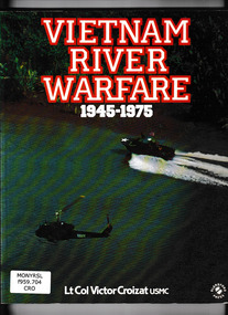 Monbulk RSL Sub Branch
Book, Blandford Press, Vietnam river warfare, 1945-1975, 1986
... Monbulk RSL Sub Branch 48 Main Road Monbulk yarra-valley-and-the-dandenong-ranges Vietnam war 1961-1975 - History Vietnam war 1961-1975 - Naval operations The story of how western forces used the "brown waterways" to move troops and equipment Index, ill, maps, p.160. Vietnam river ...The story of how western forces used the "brown waterways" to move troops and equipmentIndex, ill, maps, p.160.non-fictionThe story of how western forces used the "brown waterways" to move troops and equipmentvietnam war 1961-1975 - history, vietnam war 1961-1975 - naval operations -
 Bendigo Historical Society Inc.
Book - Geographical dictionary
... rivers and creeks, islands, bays, hills and mountains, runs and other localities and features. Entries include latitude and longitude, populations, proximity to other towns, local industries, coach and mail runs, hotels, churches and schools. Geographic dictionary Colony of Victoria Unreadable name on first page and the name of F. Houston in blue pen on first page Bailliere's Victorian Gazetteer and road guide containing the most recent and accurate information as to every place in the colony. Brown ...The Gazetteer presents an extensive a to z list of Victorian towns and villages, lakes, rivers and creeks, islands, bays, hills and mountains, runs and other localities and features. Entries include latitude and longitude, populations, proximity to other towns, local industries, coach and mail runs, hotels, churches and schools.Bailliere's Victorian Gazetteer and road guide containing the most recent and accurate information as to every place in the colony. Brown hardcover book, on the spine: Victorian Gazetteer with map 1865. The first and last pages are advertisements. The book has 442 pages listing every place in the colony. The map is not included. Compiled by Robert P. Whitworth. Published by Bailliere, Regent Street Unreadable name on first page and the name of F. Houston in blue pen on first page geographic dictionary, colony of victoria -
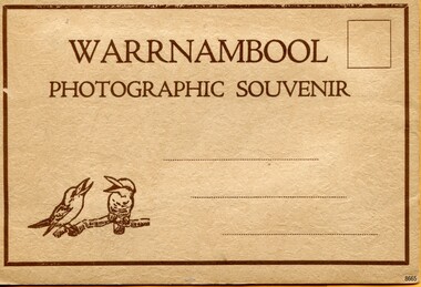 Flagstaff Hill Maritime Museum and Village
Postcard - Postcard Folder, scenes, Valentine & Sons Co. Publishing Ltd, Warrnambool Photographic Souvenir, Early-to-mod 20th century
... Ltd Sydney Municipal Buildings and Post Office Soldiers’ Memorial Hopkins River The Cliffs at Shelly Beach The Road to Sandy Beach The Breakwater and Pier “WARRNAMBOOL / PHOTOGRAPHIC SOUVENIR” Symbol: [Two facing kookaburras standing on a branch with beaks open] “Published by The Valentine Publishing Co. Pty. Ltd. Melbourne” Postcard folder, Valentine Publishing, cream cover. One of a set of three displaying images of Warrnambool and district around the mid-20th century. Print on the front and back covers is in brown ...This postcard folder is one of three in a set of postcards that were published in Victoria, Australia, and collected together. The Valentine Publishing Co. Pty. Ltd. produced this folder. Valentine and Sons was a printing and photography business based in Dundee, Scotland, and in Canada. In the early 1900s, at the height of the postcard craze, the firm published large numbers of postcards in the U.K., Canada, U.S., Australia and South Africa. From around 1900 or earlier, the firm bought many lithographic images for its postcards from local and national photographers who sold publishing rights to Valentines, and the business was famous for publishing photographs of popular sites worldwide. Postcard titles in this folder include many of those in the Rose postcard folders plus the following titles that are not duplicated. . Municipal Buildings and Post Office . Soldiers’ Memorial . Hopkins River . The Cliffs at Shelly Beach . The Road to Sandy Beach . The Breakwater and Pier This Valentine postcard folder was produced in Australia. It includes pictures from the early-to-mid 20th century. It is one of three in a set, with images of the same locations as other images in our collection but at different periods in time. Each postcard records a moment in history and is significant as a way to compare and show the changes in the local environment and community, building a story of the local history. The images record changes in the coastline, land, bay, buildings and other structures, roads, transportation and even the fashions of the times.Postcard folder, Valentine Publishing, cream cover. One of a set of three displaying images of Warrnambool and district around the mid-20th century. Print on the front and back covers is in brown ink. The front has an image of two laughing kookaburras on a branch, three address lines and an outline for a postage stamp. The back cover has the publisher’s details and a line for a return address. The cover opens like a book, and then the double-sided, Z-folded page of photographs drops downward. Titles are printed below each of the fifteen black and white photographs inside. The folder is secured on the back cover by placing a tab into a slot. The folder was produced by The Valentine Publishing Co. Pty. Ltd. Melbourne“WARRNAMBOOL / PHOTOGRAPHIC SOUVENIR” Symbol: [Two facing kookaburras standing on a branch with beaks open] “Published by The Valentine Publishing Co. Pty. Ltd. Melbourne” flagstaff hill maritime museum and village, great ocean road, shipwreck coast, warrnambool, flagstaff hill, flagstaff hill maritime museum, flagstaff hill maritime village, warramble, postcard, postcard folder, warrnambool scenes, picturesque views of warrnambool, picturesque views of warramble, lady bay, port of warrnambool, breakwater, warrnambool breakwater, viaduct, merri river footbridge, merri river suspension bridge, suspension footbridge, merri river mouth, hopkins river mouth, proudfoot's, fanny nelson, nelson's boatsheds, nelson's boathouse, boathouse, hopkins river boathouses, flett's boathouse, flett, george rose, image of a rose, rose series, rose stereograph co, rose stereographic company, lighograph, armadale victoria, lady bay beach, beach scene, lower light, concrete footbridge, 1922 footbridge, viaduct road, rose postcard, new concrete bridge, 1945, 1890, 1922, small footbridge, 1872 footbridge, 1872, merri river estuary, stingray bay, postcards, concertina fold, z fold, shipwrecked coast, maritime museum, souvenir, warrnambool local scenes, photography, local history, tourism, photographs, visitors, travel, scenes, mid-20th century, 1940s, 1950s, z-fold, 1880s, collection, correspondence, valentine publishing co. pty. ltd melbourne, valentine publishing co. pty. ltd sydney, municipal buildings and post office, soldiers’ memorial, hopkins river, the cliffs at shelly beach, the road to sandy beach, the breakwater and pier -
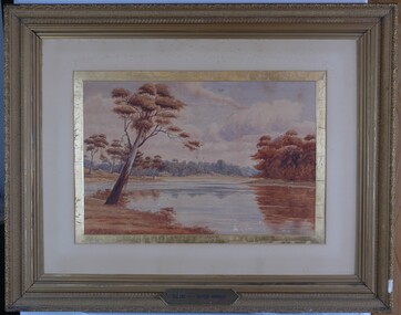
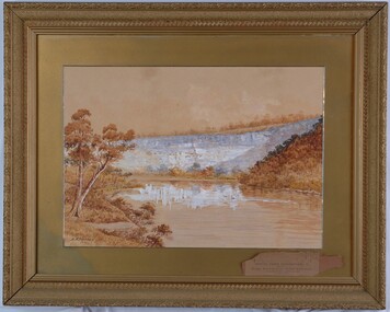 Glenelg Shire Council Cultural Collection
Painting, A.S. Murray, Scene on the River Glenelg, c. 1894
... road Art Collection Previously located in History House Landscape Glenelg River Front: A.S. Murray Back: W.HAMER, 189 Sturt Street, Ballarat, VICTORIA BUILDINGS, OPPOSITE CITY FIRE BRIGADE The painting depicts a large body of water surrounded by hills. The body of water extends from the front right corner through to the centre of the work. Predominately depicted in shades of brown ...Art Collection Previously located in History HouseThe painting depicts a large body of water surrounded by hills. The body of water extends from the front right corner through to the centre of the work. Predominately depicted in shades of brown, the body of water has a white centre with three birds (swans) sitting on the surface. In the foreground to the left of the water is a riverbank with a large brown tree. The background consists of a large blue/grey hillside and brown cloudless sky. The work has a gilded ornate frame with a gold mount and exposed canvas.Front: A.S. Murray Back: W.HAMER, 189 Sturt Street, Ballarat, VICTORIA BUILDINGS, OPPOSITE CITY FIRE BRIGADElandscape, glenelg river -
 Glenelg Shire Council Cultural Collection
Painting, A.S. Murray, Scene on the River Murray, n.d
... road Art collection Previously located in History House Front: A.S. Murray Plaque attached to frame: SCENE on the RIVER MURRAY Back: (no inscriptions) The painting depicts a large body of water surrounded by tree-covered riverbank. Depicted in shades of blue and grey, the water features patches of brown ...Art collection Previously located in History HouseThe painting depicts a large body of water surrounded by tree-covered riverbank. Depicted in shades of blue and grey, the water features patches of brown and blue which illustrate the reflections of riverbank trees. In the foreground to the left of the water is a large tree which extends up to cover the top left skyline of the work. Featured in the background is a dense patch of trees completed in shades of blue. To the right of the water is a dense patch of trees completed in shades of brown and black. These trees reach into a purple and blue cloud-filled sky. The work has a gilded ornate frame with cardboard and gold mount and exposed canvas.Front: A.S. Murray Plaque attached to frame: SCENE on the RIVER MURRAY Back: (no inscriptions) -
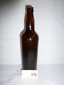 Greensborough Historical Society
Bottle, MBCV brown beer bottle, 1920c
... Greensborough Historical Society 34A Glenauburn Road Lower Plenty Lower Plenty melbourne Made for lager beer in the World War I to 1920s era. Found near Plenty River in Greensborough beer bottle mbcv bottle world war i glass spade mark MBCV on lower part of bottle. Brown ...Made for lager beer in the World War I to 1920s era.Found near Plenty River in GreensboroughBrown glass bottle, 26 fluid ounce capacity. MBCV in large spade on lower part of bottle, AGM circle monogram on base.MBCV on lower part of bottle.beer bottle, mbcv bottle, world war i, glass, spade mark -
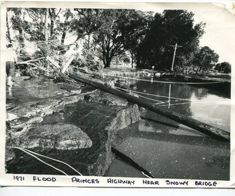 Orbost & District Historical Society
black and white photograph, February 1971
... River Bridge on the the old Princes Highway in Orbost, near the caravan park. The 1971 flood was the the worst flood on record. At Jarrahmond it was at least 11 metres and up to one and a half kilometres wide on the flats causing enormous damage to the flood plain. Records say that "The brown floodwater stain in Bass Strait could be seen from passing airliners." Considerable damage was done to railway infrastructure, roads...River Bridge on the the old Princes Highway in Orbost, near the caravan park. The 1971 flood was the the worst flood on record. At Jarrahmond it was at least 11 metres and up to one and a half kilometres wide on the flats causing enormous damage to the flood plain. Records say that "The brown floodwater stain in Bass Strait could be seen from passing airliners." Considerable damage was done to railway infrastructure, roads ...This photograph was taken near the Snowy River Bridge on the the old Princes Highway in Orbost, near the caravan park. The 1971 flood was the the worst flood on record. At Jarrahmond it was at least 11 metres and up to one and a half kilometres wide on the flats causing enormous damage to the flood plain. Records say that "The brown floodwater stain in Bass Strait could be seen from passing airliners." Considerable damage was done to railway infrastructure, roads and farms. More information from the APRIL, 2008 newsletter by John Phillips. (see orbosthistory.com.au)This is pictorial evidence of a significant local event. Floods have been an integral part of Orbost's history for hundreds of years.A black / white photograph of debris, fallen power lines, a tree across the highway and floodwaters across the road.on front at bottom - handwritten in upper case print - " 1971 FLOOD PRINCES HIGHWAY NEAR SNOWY BRIDGE"floods-orbost-1971 -
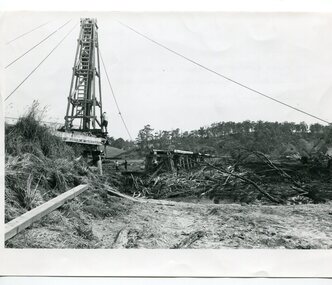 Orbost & District Historical Society
black and white photographs, 15th February 1971
... brown floodwater stain in Bass Strait could be seen from passing airliners." Considerable damage was done to railway infrastructure, roads and farms. More information from the APRIL, 2008 newsletter by John Phillips. (see orbosthistory.com.au) The railway line was destroyed and was not expected to be opened for a fortnight. Orbost was cut off by 50 square miles of Snowy River...brown floodwater stain in Bass Strait could be seen from passing airliners." Considerable damage was done to railway infrastructure, roads and farms. More information from the APRIL, 2008 newsletter by John Phillips. (see orbosthistory.com.au) The railway line was destroyed and was not expected to be opened for a fortnight. Orbost was cut off by 50 square miles of Snowy River ...The 1971 flood was the the worst flood on record. At Jarrahmond it was at least 11 metres and up to one and a half kilometres wide on the flats causing enormous damage to the flood plain. Records say that "The brown floodwater stain in Bass Strait could be seen from passing airliners." Considerable damage was done to railway infrastructure, roads and farms. More information from the APRIL, 2008 newsletter by John Phillips. (see orbosthistory.com.au) The railway line was destroyed and was not expected to be opened for a fortnight. Orbost was cut off by 50 square miles of Snowy River floodwater. These photographs are pictorial records of the 1971 floods which was a significant event in the history of Orbost. They are also associated with the East Gippsland Railway.Three black / white photographs of flood debris and flood waters near a railway line. 3102.l has a pile driver 3102.2 shows a gap in the viaduct and 3102.3 shows men with a tractor cleaning up the debris,3102.1 - on back - "1971 FLOOD REPAIRS TO ORBOST RAILWAY VIADUCT - 15th February 1971. Donated by Audrey Van Den Berg VRH 3693" 3102.2 - on back - " DAMAGE TO RAILWAY VIADUCT ACCUMULATED DEBRIS" 3102.3 - on back - "DAMAGE TO RAILWAY VIADUCT AT ORBOST. CLEAN UP BEGINS"orbost-flood-1971 orbost-viaduct-flood-damage orbost-railway -
 Orbost & District Historical Society
black and white photograph, February 1971
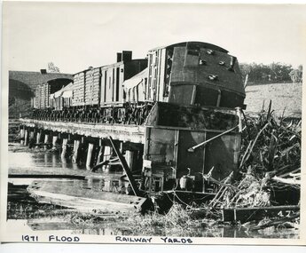
... brown floodwater stain in Bass Strait could be seen from passing airliners." Considerable damage was done to railway infrastructure, roads and farms. More information from the APRIL, 2008 newsletter by John Phillips. (see orbosthistory.com.au) The railway line was destroyed and was not expected to be opened for a fortnight. Orbost was cut off by 50 square miles of Snowy River...brown floodwater stain in Bass Strait could be seen from passing airliners." Considerable damage was done to railway infrastructure, roads and farms. More information from the APRIL, 2008 newsletter by John Phillips. (see orbosthistory.com.au) The railway line was destroyed and was not expected to be opened for a fortnight. Orbost was cut off by 50 square miles of Snowy River ...The 1971 flood was the the worst flood on record. At Jarrahmond it was at least 11 metres and up to one and a half kilometres wide on the flats causing enormous damage to the flood plain. Records say that "The brown floodwater stain in Bass Strait could be seen from passing airliners." Considerable damage was done to railway infrastructure, roads and farms. More information from the APRIL, 2008 newsletter by John Phillips. (see orbosthistory.com.au) The railway line was destroyed and was not expected to be opened for a fortnight. Orbost was cut off by 50 square miles of Snowy River floodwater. This train was being shunted across the viaduct when waters smashed through washing away several trucks sending the crew running for their lives.This is pictorial evidence of a significant local event. It is connected to the history of the railway in East Gippsland.A large black / white photograph of flooded railway yards with a train engine stranded on a small section of track surrounded by water and debris.on front - "1971 Flood, Railway Yards"floods-1971-orbost orbost-railway natural-disasters-orbost -
 Orbost & District Historical Society
black and white photograph, February, 1971
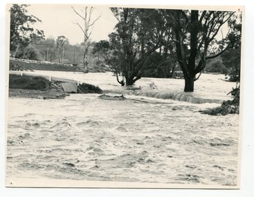
... River from changing its course. The 1971 flood was the the worst flood on record. At Jarrahmond it was at least 11 metres and up to one and a half kilometres wide on the flats causing enormous damage to the flood plain. Records say that "The brown floodwater stain in Bass Strait could be seen from passing airliners." Considerable damage was done to railway infrastructure, roads...River from changing its course. The 1971 flood was the the worst flood on record. At Jarrahmond it was at least 11 metres and up to one and a half kilometres wide on the flats causing enormous damage to the flood plain. Records say that "The brown floodwater stain in Bass Strait could be seen from passing airliners." Considerable damage was done to railway infrastructure, roads ...This photograph shows the floodwaters during the 1971 flood at Orbost. The two mahogany trees in the photograph stopped the Snowy River from changing its course. The 1971 flood was the the worst flood on record. At Jarrahmond it was at least 11 metres and up to one and a half kilometres wide on the flats causing enormous damage to the flood plain. Records say that "The brown floodwater stain in Bass Strait could be seen from passing airliners." Considerable damage was done to railway infrastructure, roads and farms. More information from the APRIL, 2008 newsletter by John Phillips. (see orbosthistory.com.au)This is a pictorial record of a significant event in the history of floods in Orbost.A black / white photograph of raging floodwaters at the bottom of the Orbost township.orbost-flood-1971 -
 Federation University Historical Collection
Newspaper, Lal Lal Iron and Coal as reported in the Ballarat Courier, 10/07/1923
... Barker Library (top floor) Mount Helen goldfields electricity lal lal lal lal iron lal lal coalfield morwell gippsland Crockers Arnolds Harry Hall Ewins Harry Davies Fred Halls The London Drapery Lal Lal Brown coal Ripon's roads Mount Cole Springs Soldier Settlement Rates Beaufort Creswick brass band Officers Daylesford Road Deviation to Hepburn Springs Dereel Public Telephone State Electricity Supply for Beaufort Newlyn W.E. Bennett Ascot Avoca Golf Tournament Chinese Herbalists C. Marks and Co. London Drapery Creer the Cashman Chamberlain's Cough Remedy Cornell's Little Liver Pills Paynes W. Fley Chemist Bickart and Dawson Rivers ....1) Pages 7 to 10 of the Ballarat Courier, 10 July 1923. Page 7 includes the article 'Cheap electricity' and poses questions such as 'should Ballarat look to Morwell for cheap power?', and should an independent power plant be installed at Crockers, Arnolds, Harry Hall, Ewins, Harry Davies, Fred Halls, The London Drapery there. Page 9 includes articles on Ripon's roads, Mount Cole Springs; Soldier Settlement Rates Beaufort; Creswick brass band Officers; Daylesford Road Deviation to Hepburn Springs; Dereel Public Telephone; State Electricity Supply for Beaufort; Newlyn Valedictory to Mr and Mrs W. E. Bennett Page 9 - Racing at Ascot; Avoca Golf Tournament, Chinese Herbalists Page 10 - Auctions and house sales Advertisements include Harry Davies; Fred Halls; C. Marks and Co., London Drapery, Creer the Cashman; Chamberlain's Cough Remedy; Cornell's Little Liver Pills; Paynes; W. Fley Chemist; Bickart and Dawson; Rivers; Allchin Bros; J. Bartam & Son .2) Ballarat Courier, 30 July 1937, page 1 and 2 Page 1 reports Lal Lal's Iron Ore Company being formed. Page 2 reports the Prospectus of the lal lal Iron and Steel Blast Furnaces Mining Company, No Liability; Mining News - Wattle Gully; Commercial News Advertisements include Crockers, Arnolds, Harry Hall, Ewins, Harry Davies, Fred Halls, The London Drapery electricity, lal lal, lal lal iron, lal lal coalfield, morwell, gippsland, crockers, arnolds, harry hall, ewins, harry davies, fred halls, the london drapery, lal lal brown coal, ripon's roads, mount cole springs, soldier settlement rates beaufort, creswick brass band officers, daylesford road deviation to hepburn springs, dereel public telephone, state electricity supply for beaufort, newlyn, w.e. bennett, ascot, avoca golf tournament, chinese herbalists, c. marks and co., london drapery, creer the cashman, chamberlain's cough remedy, cornell's little liver pills, paynes, w. fley chemist, bickart and dawson, rivers, allchin bros, j. bartam & son, lal lal iron and steel blast furnaces mining company, wattle gully -
 Coal Creek Community Park & Museum
Music Book, First Piano Lessons, Book II, The Countryside
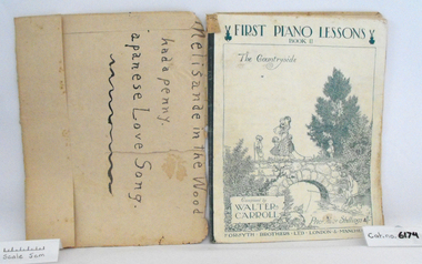
... Coal Creek Community Park & Museum 12 Silkstone Road Korumburra gippsland Music book "First Piano Lessons, Book II, The Countryside", Composed by Walter Carroll, covered in brown discoloured paper, original cover has a white background with charming illustration of children walking over stone bridge and fishing in the river, printed in blue.. ...Music book "First Piano Lessons, Book II, The Countryside", Composed by Walter Carroll, covered in brown discoloured paper, original cover has a white background with charming illustration of children walking over stone bridge and fishing in the river, printed in blue.. -
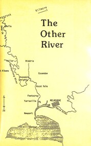 Sunshine and District Historical Society Incorporated
Film - The Other River Video
... Brimbank Library, 301 Hampshire Road, Sunshine 3020. melbourne A history of the Maribyrnong River, the main ecological feature including its wildlife of the Western Suburbs, Victoria, Australia. Maribyrnong River White Faced Heron Dusky Moorhen Swallows Crimson Rosella Cormorant Kookaburra Striated Pardalote Fairy Wren Brown Thornbill Eastern Spinebill Willie Wagtail Echidna Silver Gulls Ibis Pacific Black Duck Black Shouldered Kite The Other River VHS Video Tape Film The Other River Video ...A history of the Maribyrnong River, the main ecological feature including its wildlife of the Western Suburbs, Victoria, Australia.The Other Rivermaribyrnong river, white faced heron, dusky moorhen, swallows, crimson rosella, cormorant, kookaburra, striated pardalote, fairy wren, brown thornbill, eastern spinebill, willie wagtail, echidna, silver gulls, ibis, pacific black duck, black shouldered kite -
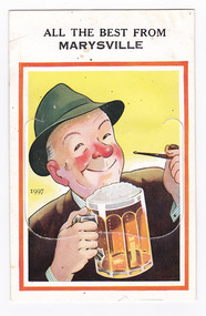 Marysville & District Historical Society
Postcard (item) - Novelty postcard, Valentine Publishing Co. Pty. Ltd, ALL THE BEST FROM MARYSVILLE, 1940's-1960's
... A novelty postcard with pull-out strip of 9 miniature photographs that was produced by the Valentine Publishing Co as a souvenir of Marysville. marysville victoria postcard souvenir valentine publishing co crossways cabaret (image 1) taggerty river (image 2) acheron way (image 3) blacks spur road (image 4) nicholl's lookout (image 5) main street marysville (image 6) sugarloaf bay eildon (image 7) steavenson falls (image 8) cumberland falls (image 9) ALL THE BEST FROM/ MARYSVILLE 1997 PRINTED PAPER MAILING NOVELTY TO OPEN RAISE FLAP From VALENTINE'S "MAIL NOVELTY" POST CARD COPYRIGHT Printed in Great Britain To Postcard has an illustration of a man wearing a green hat and a brown coat. ...A novelty postcard with pull-out strip of 9 miniature photographs that was produced by the Valentine Publishing Co as a souvenir of Marysville.A novelty postcard with pull-out strip of 9 miniature photographs that was produced by the Valentine Publishing Co as a souvenir of Marysville.ALL THE BEST FROM/ MARYSVILLE 1997 PRINTED PAPER MAILING NOVELTY TO OPEN RAISE FLAP From VALENTINE'S "MAIL NOVELTY" POST CARD COPYRIGHT Printed in Great Britain Tomarysville, victoria, postcard, souvenir, valentine publishing co, crossways cabaret (image 1), taggerty river (image 2), acheron way (image 3), blacks spur road (image 4), nicholl's lookout (image 5), main street marysville (image 6), sugarloaf bay eildon (image 7), steavenson falls (image 8), cumberland falls (image 9) -
 Sunshine and District Historical Society Incorporated
Photograph - Rupertswood Photo Album, Early 1900s
... Rupertswood Sunbury Hugh Victor McKay 2337.01 - Rupertswood Photo Album - Our First Home The Lodge 2337.02 - Rupertswood Photo Album - Ruperstwood Photo 01 2337.03 - Rupertswood Photo Album - Rupertswood Photo 02 2337.04 - Rupertswood Photo Album - The Lake 2337.05 - Rupertswood Photo Album - The Lake 2337.06 - Rupertswood Photo Album - From The Hill 2337.07 - Rupertswood Photo Album - The Hot House 2337.08 - Rupertswood Photo Album - Dairy And Piggeries 2337.09 - Rupertswood Photo Album - The Vegetable Garden 2337.10 - Rupertswood Photo Album - Jackson's Creek 2337.11 - Rupertswood Photo Album - Shorn Sheep 2337.12 - Rupertswood Photo Album - Lucerne Flats 2337.13 - Rupertswood Photo Album - River Flats 2337.14 - Rupertswood Photo Album - Milking Shed And Dairy 2337.15 - Rupertswood Photo Album - Silo And Piggeries 2337.16 - Rupertswood Photo Album - The Shearing Shed 2337.17 - Rupertswood Photo Album - Share Farmers Cottage 2337.18 - Rupertswood Photo Album - Ploughing River Flats 2337.19 - Rupertswood Photo Album - Charlie Shaw And 'Peter' 2337.20 - Rupertswood Photo Album - Shar Farmers Cottage 2337.21 - Rupertswood Photo Album - Front View And The Fountain 2337.22 - Rupertswood Photo Album - Side View, Tennis Courts And Wattle Lawn 2337.23 - Rupertswood Photo Album - Making Road And Pop & Mag's Camp At Moleside Glenelg River 2337.24 - Rupertswood Photo Album - Cutting Hay And Boring For Water At Rupertswood 2337.25 - Rupertswood Photo Album - Ploughing By Bullocks And By Bertha 2337.26 - Rupertswood Photo Album - Progress Of The Sydney Habour Bridge 2337.27 - Rupertswood Photo Album - Progress Of The Sydney Habour Bridge 2337.28 - Rupertswood Photo Album - Tennis Girls 2337.29 - Rupertswood Photo Album - Tennis Girls Brown photo photo albums from the early 1900's Photograph Rupertswood Photo Album ...2337.01 - Rupertswood Photo Album - Our First Home The Lodge 2337.02 - Rupertswood Photo Album - Ruperstwood Photo 01 2337.03 - Rupertswood Photo Album - Rupertswood Photo 02 2337.04 - Rupertswood Photo Album - The Lake 2337.05 - Rupertswood Photo Album - The Lake 2337.06 - Rupertswood Photo Album - From The Hill 2337.07 - Rupertswood Photo Album - The Hot House 2337.08 - Rupertswood Photo Album - Dairy And Piggeries 2337.09 - Rupertswood Photo Album - The Vegetable Garden 2337.10 - Rupertswood Photo Album - Jackson's Creek 2337.11 - Rupertswood Photo Album - Shorn Sheep 2337.12 - Rupertswood Photo Album - Lucerne Flats 2337.13 - Rupertswood Photo Album - River Flats 2337.14 - Rupertswood Photo Album - Milking Shed And Dairy 2337.15 - Rupertswood Photo Album - Silo And Piggeries 2337.16 - Rupertswood Photo Album - The Shearing Shed 2337.17 - Rupertswood Photo Album - Share Farmers Cottage 2337.18 - Rupertswood Photo Album - Ploughing River Flats 2337.19 - Rupertswood Photo Album - Charlie Shaw And 'Peter' 2337.20 - Rupertswood Photo Album - Shar Farmers Cottage 2337.21 - Rupertswood Photo Album - Front View And The Fountain 2337.22 - Rupertswood Photo Album - Side View, Tennis Courts And Wattle Lawn 2337.23 - Rupertswood Photo Album - Making Road And Pop & Mag's Camp At Moleside Glenelg River 2337.24 - Rupertswood Photo Album - Cutting Hay And Boring For Water At Rupertswood 2337.25 - Rupertswood Photo Album - Ploughing By Bullocks And By Bertha 2337.26 - Rupertswood Photo Album - Progress Of The Sydney Habour Bridge 2337.27 - Rupertswood Photo Album - Progress Of The Sydney Habour Bridge 2337.28 - Rupertswood Photo Album - Tennis Girls 2337.29 - Rupertswood Photo Album - Tennis Girlsrupertswood, sunbury, hugh victor mckay -
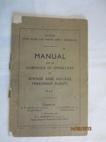 Wannon Water
Manual/book, Government printer, Manual for the guidance of operators of sewage and sullage treatment plants 1943, 1943
... road Compiled by H.W.McCay, Divisional Engineer and L.B.Cullen, Assistant Engineer in collaboration with E.A. Hepburn, Sanitary Engineer, Department of Public Health State Rivers and Water Supply Commission was the government body responsible for water supply. Water Supply Sewage Wastewater management Operating manuals Water Reclamation Plant Handwritten L Bush on top of first page A booklet, with a front brown ...Compiled by H.W.McCay, Divisional Engineer and L.B.Cullen, Assistant Engineer in collaboration with E.A. Hepburn, Sanitary Engineer, Department of Public HealthState Rivers and Water Supply Commission was the government body responsible for water supply.A booklet, with a front brown cover, back cover missing, 61 pagesHandwritten L Bush on top of first pagewater supply, sewage, wastewater management, operating manuals, water reclamation plant -
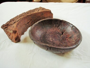 Wangaratta Historical Society
Wooden Fruit Bowl, Red Gum Bowl
... river at Tarrawingee (12 km from Wangaratta)where it had been submerged for years. It was made on a lathe by Ken Hill. The bowl warped and cracked shortly after being turned. A piece of the wood was taken to the USA by a visitor where it was carbon dated to be 4500 years old Measurements: Diameter: 22cm Height: 6cm Colour: Dark red brown Photographed beside a piece of natural red gum Tarrawingee is 12 Km North East of Wangaratta on the Great Alpine Road Significance: 4500 year old red gum wood is rare in this area. ...river at Tarrawingee (12 km from Wangaratta)where it had been submerged for years. It was made on a lathe by Ken Hill. The bowl warped and cracked shortly after being turned. A piece of the wood was taken to the USA by a visitor where it was carbon dated to be 4500 years old Measurements: Diameter: 22cm Height: 6cm Colour: Dark red brown Photographed beside a piece of natural red gum Tarrawingee is 12 Km North East of Wangaratta on the Great Alpine Road Significance: 4500 year old red gum wood is rare in this area. ...This wood is made from Red River Gum tree wood, these trees live for between 500 to 1,000 years of age. The wood in this bowl has been carbon dated in the USA to be 4,500 years old.This bowl is significant because of the age of the wood it is made from. 000016 Wooden Fruit Bowl The timber this fruit bowl was made from was a red gum tree taken from the Ovens river at Tarrawingee (12 km from Wangaratta)where it had been submerged for years. It was made on a lathe by Ken Hill. The bowl warped and cracked shortly after being turned. A piece of the wood was taken to the USA by a visitor where it was carbon dated to be 4500 years old Measurements: Diameter: 22cm Height: 6cm Colour: Dark red brown Photographed beside a piece of natural red gum Tarrawingee is 12 Km North East of Wangaratta on the Great Alpine Road Significance: 4500 year old red gum wood is rare in this area. red river gum wooden bowl wangaratta historical society