Showing 193 items matching "contours"
-
 University of Melbourne, Burnley Campus Archives
Map, Drainage & Contours City of Hawthorn, c. 1970
... Drainage & Contours City of Hawthorn......contours...Area bounded by Glenferrie Road, Power Street, Barkers Road, Burwood Road Drainage & Contours City of Hawthorn Map ...Copy of map with some coloured and pencil annotations. Scale 1:2000. Marked "2". Area bounded by Glenferrie Road, Power Street, Barkers Road, Burwood Roadhawthorn, glenferrie sports ground, grace park, contours -
 Melbourne Tram Museum
Document - Report, Melbourne & Metropolitan Tramways Board (MMTB), "Travel time contours for travel by tram and train from the central business area", Jul. 1966
... "Travel time contours for travel by tram and train from the central business area"...Report - Foolscap 11 typed pages, 12 bound sheets of diagrams and tables with card covers, with red binding strips, titled ""Travel time contours for travel by tram and train from the central business area", dated July 1966. ...Looks at journey time for both trams and trains with two speeds - 10mph and 18mph. "Travel time contours for travel by tram and train from the central business area" Document Report Melbourne & Metropolitan Tramways Board (MMTB) ...Report - Foolscap 11 typed pages, 12 bound sheets of diagrams and tables with card covers, with red binding strips, titled ""Travel time contours for travel by tram and train from the central business area", dated July 1966. Looks at journey time for both trams and trains with two speeds - 10mph and 18mph.In top left hand corner "Lees" in penciltrams, tramways, mmtb, tramways, railways, speed of services, travel promotion -
Moorabbin Air Museum
Drawing (Item) - Airsearch Manufacturing Company Nacelle Contours 868100
... Airsearch Manufacturing Company Nacelle Contours 868100...Moorabbin Air Museum Moorabbin Airport 12 First Street Moorabbin melbourne Airsearch Manufacturing Company Nacelle Contours 868100 Drawing Airsearch Manufacturing Company Nacelle Contours 868100 ... -
Moorabbin Air Museum
Document (item) - C.A.C Macchi Loft Contours Originals MB326H
... C.A.C Macchi Loft Contours Originals MB326H...Moorabbin Air Museum Moorabbin Airport 12 First Street Moorabbin melbourne C.A.C Macchi Loft Contours Originals MB326H Document C.A.C Macchi Loft Contours Originals MB326H ... -
University of Melbourne, Burnley Campus Archives
Plan - Photocopy, Contour Map 1891, 1891
... Contour Map 1891...Photocopy of plan showing contour lines from Yarra River. Shows Pavilion and Principal's Residence but not much of the garden design. ..."Contour map 1891" written in biro...From Central Plan Office Dept. of Natural Resources. Contour Map 1891 Plan Photocopy ...Photocopy of plan showing contour lines from Yarra River. Shows Pavilion and Principal's Residence but not much of the garden design. From Central Plan Office Dept. of Natural Resources."Contour map 1891" written in biroyarra river, pavilion, burnley horticultural college, burnley gardens -
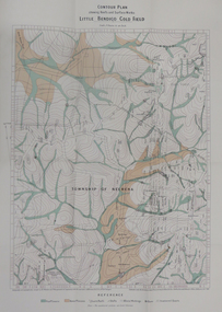
Whitehorse Historical Society Inc.
Map, Dandenong Ranges Area, 1955
... Scale 10 chains : 1 inch. Contours marked....Scale 10 chains : 1 inch. Contours marked....Scale 10 chains : 1 inch. Contours marked. Dandenong Ranges Area Map Map ...Sheet 13. Parts of Parishes: Nunawading, Mulgrave and Scoresby.Sheet 13. Parts of Parishes: Nunawading, Mulgrave and Scoresby. Includes area of Vermont South marked as proposed Township of Norwich. Scale 10 chains : 1 inch. Contours marked.Sheet 13. Parts of Parishes: Nunawading, Mulgrave and Scoresby. maps, vermont south, wantirna, dandenong creek -
 Robin Boyd Foundation
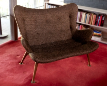
Furniture - Sofa, Grant Featherston, RS161 Featherston Contour Settee, 1951
... RS161 Featherston Contour Settee...This pair of RS161 Grant Featherston Contour Settees (1951) were previously in the Boyd home in Camberwell. ...Twenty five self-covered buttons. Curvaceous contour shape....Twenty five self-covered buttons. Curvaceous contour shape. RS161 Featherston Contour Settee Furniture Sofa Grant Featherston ...This pair of RS161 Grant Featherston Contour Settees (1951) were previously in the Boyd home in Camberwell. Robin Boyd designed the Ivanhoe home and Grant and Mary Featherston (1967).Two two-seater settees, with four timber cigar shaped legs with round flat metal brass feet. Olive green/copper loose weave fabric. Wool/silk blend fabric. Twenty five self-covered buttons. Curvaceous contour shape.walsh st furnishings, settee, featherston, robin boyd -
 Kew Historical Society Inc
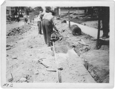
Photograph - Instructional photograph No.2: Using concrete for street kerbs, Portland Cement Association, 1921
... "2nd - Tamping Concrete into Approximate Contour"...The photos demonstrate knowledge about and the use of concrete in street works in a major Melbourne municipality at an early period. street works kerbing gutters concrete portland cement association "2nd - Tamping Concrete into Approximate Contour" Black and white photograph with printed instructions on the reverse showing the production of concrete kerbing on 67th Street, West Allis, Milwaukee, Wisconsin (USA). ...One of seven photographs produced by the Portland Cement Association in 1921 showing how concrete kerbs could be created. Portland Cement Association (PCA) was founded in 1916. From 1917, the association actively promoted the benefits of concrete for road works in Australian newspapers. In the nineteenth century in Melbourne (Vic.) 'made roads' typically had gutters and kerbing lined with bluestone.The photographs are important evidence of the availability of instructional models for the use of concrete in street works in Victoria. While the photographs date from the early 1920s, the use of concrete for kerbing did not reach its maturity until after World War 2. The photos demonstrate knowledge about and the use of concrete in street works in a major Melbourne municipality at an early period.Black and white photograph with printed instructions on the reverse showing the production of concrete kerbing on 67th Street, West Allis, Milwaukee, Wisconsin (USA). The photograph was produced by the Portland Cement Association of Chicago in 1921 and used within the Chief Engineer's Department of the City of Kew (Vic.)."2nd - Tamping Concrete into Approximate Contour"street works, kerbing, gutters, concrete, portland cement association -
 Creswick Campus Historical Collection - University of Melbourne
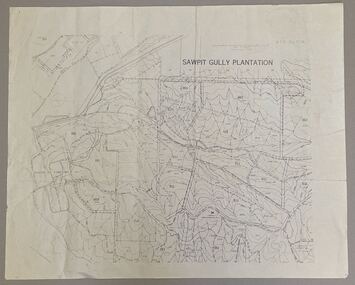
Map - Sawpit Gully Plantation showing plantation lots up to 1976, Sawpit Gully Plantation W.B.P No. 304
... Printed map, contours at 25 ft....Creswick Campus Historical Collection - University of Melbourne 4 Water Street University of Melbourne Creswick Campus Building 719/718 Creswick goldfields Printed map, contours at 25 ft. Sawpit Gully Plantation W.B.P No. 304 Map Sawpit Gully Plantation showing plantation lots up to 1976 ...Printed map, contours at 25 ft. -
 Bendigo Military Museum
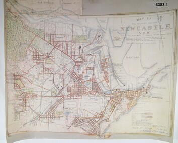
Map - Map of Newcastle NSW 4 Inch - 1 Mile 1910, Australian Intelligence Corps, Nov 1910
... It was unique because it was now produced on an accurate gridded base and included contouring. Lynch and Davies transferred to the Royal Australian Engineers (RAE) whilst Barrett and Wilcox returned to the UK in June 1913. ...A gridded Map of Newcastle NSW area scale four inches to one mile with 25 feet interval contouring. Coloured hand drawn map produced in 1910. ...It was unique because it was now produced on an accurate gridded base and included contouring. Lynch and Davies transferred to the Royal Australian Engineers (RAE) whilst Barrett and Wilcox returned to the UK in June 1913. ...In 1909 the Australian Army Headquarters realized that mapping in Australia was either non existent or inadequate for Military use. It was requested that Australia borrow Survey personnel from the UK Royal Engineers (RE) for a two-year detachment. On 11 April 1910 four RE NCOs arrived in Melbourne comprising CPL J Lynch, and LCPLs AH Barrett, EF Davies and R Wilcox. LCPL Barrett had 12yrs experience with RE. They were aiming at producing eight map sheets per year covering about 7,000 square miles (18,000 square Km) This map sheet of the Newcastle area was produced using plane table methods and was surveyed and hand drawn by LCPL A Barrett Oct - Nov 2010. It was unique because it was now produced on an accurate gridded base and included contouring. Lynch and Davies transferred to the Royal Australian Engineers (RAE) whilst Barrett and Wilcox returned to the UK in June 1913. Barrett returned to Australia in 1915 and also enlisted in the RAE and served until 1919.A gridded Map of Newcastle NSW area scale four inches to one mile with 25 feet interval contouring. Coloured hand drawn map produced in 1910. Signed by " A Barrett LCPL Royal Engineers"royal australian survey corps, rasvy, fortuna, army svy regt, army survey regiment -
 Federation University Historical Collection
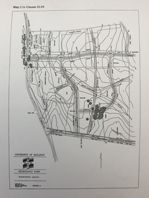
Plan, Ballarat Technology Park plans, c1998
... .1) Alotment plan .2) contour plan...Barker Library (top floor) Mount Helen goldfields ballarat technology park mount helen campus canadian wetlands ballarat to buninyong railway line sub-division layout .1) Alotment plan .2) contour plan Ballarat Technology Park plans Plan ....1) Alotment plan .2) contour planballarat technology park, mount helen campus, canadian wetlands, ballarat to buninyong railway line, sub-division layout -
 National Vietnam Veterans Museum (NVVM)
Map, A Contour Map of South Vietnam
... A Contour Map of South Vietnam....A contour map showing ATF Base Patrols....National Vietnam Veterans Museum (NVVM) 25 Veterans Drive Newhaven phillip-island-and-the-bass-coast ATF Base Patrols A contour map showing ATF Base Patrols. A Contour Map of South Vietnam. ...A contour map showing ATF Base Patrols.atf base patrols -
 Federation University Historical Collection
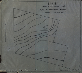
Plan, SMB Block at White Flat
... Plan of contours at White Flat, Ballarat Central. ...white flat ballarat school of mines ballarat central Plan of contours at White Flat, Ballarat Central. SMB Block at White Flat Plan Plan ...Plan of contours at White Flat, Ballarat Central. white flat, ballarat school of mines, ballarat central -
 Federation University Historical Collection
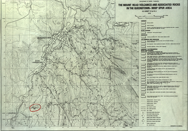
Map, The Mount Read Volcanics and Associated Rocks in the Queenstown - Whip Spur Area, 1978, 1978
... Contour map of the Queenstown area in Tasmania, Australia....department of mines tasmania volcanics mount read queesntown whip spur mining king river gormanston mt owen lynchford Contour map of the Queenstown area in Tasmania, Australia. ...Contour map of the Queenstown area in Tasmania, Australia.department of mines tasmania, volcanics, mount read, queesntown, whip spur, mining, king river, gormanston, mt owen, lynchford -
 Greensborough Historical Society
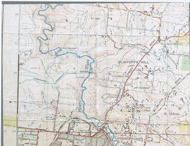
Map, John Monash, 1913 Map of Greensborough, 1913
... Colour map showing land contours and place names...Greensborough - maps 1913 Colour map showing land contours and place names 1913 Map of Greensborough Map Map John Monash ...1913 Map of Greensborough, possibly by John Monash. This map shows the area to the north of the township.Colour map showing land contours and place namesgreensborough - maps, 1913 -
 Bendigo Military Museum
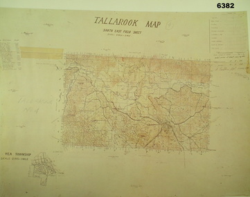
Map - Australian Topographical Survey TALLAROOK SE Sheet, 1 inch:1 Mile, NW portion Plane Table Field sheet 1923, Australian Survey Corps, 1923
... Of particular interest is the fact that this is a heighted compilation with contouring (required for Military use) as many early maps were purely planimetric. ...Reprinted coloured Image of Australian Topographical Survey TALLAROOK SE field Sheet,1 inch:1 Mile, hand drawn contoured Plane Table Field sheet. Signed by Sgt J Cullen Australian Survey Corps November1923. ...Of particular interest is the fact that this is a heighted compilation with contouring (required for Military use) as many early maps were purely planimetric. ...This is a coloured reproduction print of an original Plane Table compilation map sheet of Tallarook area 1inch to 1 Mile scale compiled by Sgt Jack Cullen Australian Survey Corps 12 November 1923 and signed by Capt J Lynch. Capt Lynch and Sgt Cullen were both foundation members of the Australian Survey Corps. Of particular interest is the fact that this is a heighted compilation with contouring (required for Military use) as many early maps were purely planimetric. The reverse side of this print is a copy of the Nagambie plane table South West field sheet.Reprinted coloured Image of Australian Topographical Survey TALLAROOK SE field Sheet,1 inch:1 Mile, hand drawn contoured Plane Table Field sheet. Signed by Sgt J Cullen Australian Survey Corps November1923. An enlargement of YEA Township 2 Inches to 1 Mile Scale.royal australian survey corps, rasvy, fortuna, army survey regiment, army svy regt, asr -
Broadmeadows Historical Society & Museum
Map - Map of Australia, John Bartholomew & Son Ltd, Contour- coloured world map series: Australia, c. 1955
... Contour- coloured world map series: Australia...Map of Australia - Colour contoured - printed on cloth, scale 1:5,000,000...Broadmeadows Historical Society & Museum 21 Pearcedale Parade Broadmeadows melbourne Printed 1955 Quality Map in good condition, can be used for research purposes Australia Map Historical information Education Map of Australia - Colour contoured - printed on cloth, scale 1:5,000,000 Contour- coloured world map series: Australia Map Map of Australia John Bartholomew & Son Ltd Mr. ...Printed 1955Quality Map in good condition, can be used for research purposesMap of Australia - Colour contoured - printed on cloth, scale 1:5,000,000australia, map, historical information, education -
 B-24 Liberator Memorial Restoration Australia Inc
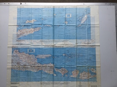
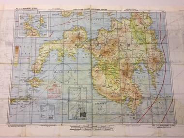
Map - US World War II-coloured map, - Southwest Pacific Area, No.22 Southwestern, No.26 East Java, No.25 Timor, 1943
... A multi-coloured, contoured, double-sided map printed on acetate rayon ...This map, printed on acetate rayon, is an original US 'escape and evasion' kit map from World War II. world war ii silk maps united states of america a188 AAF Cloth Map - Southwest Pacific Area Side 1 - No. 22 Southwestern and No. 26 East Java Side 2 - No. 25 Timor A multi-coloured, contoured, double-sided map printed on acetate rayon Map US World War II-coloured map, - Southwest Pacific Area, No.22 Southwestern, No.26 East Java, No.25 Timor ...Silk and rayon maps were produced by the United States (c. 7.5 million in total), Great Britain (some 1.75 million in total) and Australia during World War II. They were issued to Allied military personnel as part of 'escape and evasion' kits.This map, printed on acetate rayon, is an original US 'escape and evasion' kit map from World War II.A multi-coloured, contoured, double-sided map printed on acetate rayon AAF Cloth Map - Southwest Pacific Area Side 1 - No. 22 Southwestern and No. 26 East Java Side 2 - No. 25 Timorworld war ii, silk maps, united states of america, a188 -
 B-24 Liberator Memorial Restoration Australia Inc
Map - US World War II multi-coloured map - Philippine Series, No. C-43 Mindanao Series, No. C-44 North Borneo, 1944
... A multi-coloured, contoured, double-sided map printed on acetate rayon ...C.44 North Borneo A multi-coloured, contoured, double-sided map printed on acetate rayon Map US World War II multi-coloured map - Philippine Series, No. ...Silk and rayon maps were produced by the United States (c. 7.5 million in total), Great Britain (some 1.75 million in total) and Australia during World War II. They were issued to Allied military personnel as part of 'escape and evasion' kits.This map, printed on acetate rayon, is an original US 'escape and evasion' kit map from World War II.A multi-coloured, contoured, double-sided map printed on acetate rayon AAF Cloth Chart - Philippine Series Side 1 - No. C-43 Mindanao Series Side 2 - No. C.44 North Borneounited states of america, silk and rayon maps, world war ii -
 B-24 Liberator Memorial Restoration Australia Inc
Map - US World War II multi-coloured map, Side 1 - No. C-47 South Borneo, Side 2 - No. C-48 West Java, 1944
... A multi-coloured, contoured, double-sided map printed on acetate rayon ...C.48 West Java A multi-coloured, contoured, double-sided map printed on acetate rayon Map US World War II multi-coloured map, Side 1 - No. ...Silk and rayon maps were produced by the United States (c. 7.5 million in total), Great Britain (some 1.75 million in total) and Australia during World War II. They were issued to Allied military personnel as part of 'escape and evasion' kits.This map, printed on acetate rayon, is an original US 'escape and evasion' kit map from World War II.A multi-coloured, contoured, double-sided map printed on acetate rayon AAF Cloth Chart Side 1 - No. C-47 South Borneo Side 2 - No. C.48 West Javaunited states of america, silk and rayon maps, world war ii, a191 -
 B-24 Liberator Memorial Restoration Australia Inc
Map - US World War II multi-coloured map- Southwest Pacific Area, No. 23 North Celebes, No. 24 South Celebes, 1942-1943
... A multi-coloured, contoured, double-sided map printed on acetate rayon ...This map, printed on acetate rayon, is an original US 'escape and evasion' kit map from World War II. world war ii silk maps united states of america a189 AAF Cloth Map - Southwest Pacific Area Side 1 - No. 23 North Celebes Side 2 - No. 24 South Celebes A multi-coloured, contoured, double-sided map printed on acetate rayon Map US World War II multi-coloured map- Southwest Pacific Area, No. 23 North Celebes, No. 24 South Celebes ...Silk and rayon maps were produced by the United States (c. 7.5 million in total), Great Britain (some 1.75 million in total) and Australia during World War II. They were issued to Allied military personnel as part of 'escape and evasion' kits.This map, printed on acetate rayon, is an original US 'escape and evasion' kit map from World War II.A multi-coloured, contoured, double-sided map printed on acetate rayon AAF Cloth Map - Southwest Pacific Area Side 1 - No. 23 North Celebes Side 2 - No. 24 South Celebesworld war ii, silk maps, united states of america, a189 -
 Bendigo Historical Society Inc.
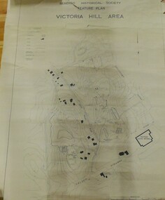
Map - VICTORIA HILL AREA
... Contour plan of the Victoria Hill area, with all of the historical features marked and named...CMF increment May 1971 Contour plan of the Victoria Hill area, with all of the historical features marked and named Map VICTORIA HILL AREA ...Contour plan of the Victoria Hill area, with all of the historical features marked and namedCompiled by AHQ Survey Regt. CMF increment May 1971map, reserves, mining, bendigo goldfield, victoria hill -
 Federation University Historical Collection
Map - Report, H.S. Whitelaw, Report on the Little Bendigo or Nerrina Gold-Field, Ballarat, 1901, 1901
... Blue soft covered book. Includes Contour plan of the Little Bendigo Goldfield...Barker Library (top floor) Mount Helen goldfields little bendigo nerrena nerrina h.s. whitelaw Blue soft covered book. Includes Contour plan of the Little Bendigo Goldfield Report on the Little Bendigo or Nerrina Gold-Field, Ballarat, 1901 Map Report H.S. ...Blue soft covered book. Includes Contour plan of the Little Bendigo Goldfieldlittle bendigo, nerrena, nerrina, h.s. whitelaw -
Federation University Historical Collection
Architectural Drawing, Ballarat School of Mines Mount Helen Development, c1967
... Architectural Drawing for the Mount Helen campus. Contour plan of Mt Helen campus....mount helen campus ballarat college of advanced education l.h. vernon and associates building f building g Architectural Drawing for the Mount Helen campus. Contour plan of Mt Helen campus. Ballarat School of Mines Mount Helen Development Architectural Drawing L.H. ...Architectural Drawing for the Mount Helen campus. Contour plan of Mt Helen campus.mount helen campus, ballarat college of advanced education, l.h. vernon and associates, building f, building g -
 B-24 Liberator Memorial Restoration Australia Inc
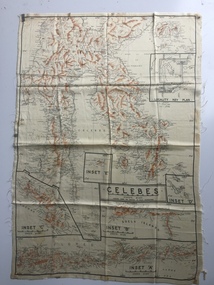
Map - Australian World War II silk map of Celebes, 1940s
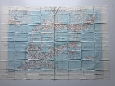
... An oblong, cream colour, single-sided map printed in black and white with brown contours, Celebes ...This silk map, one of relatively few produced in Australia (most Australian RAAF pilots and crew were issued with British and US maps), is an original map from World War II. world war ii silk maps australia a185 'Prepared under the direction of RAAF Headquarters' Celebes (with Insets 'A' to 'E') An oblong, cream colour, single-sided map printed in black and white with brown contours, Celebes Map Australian World War II silk map of Celebes ...Silk and rayon maps were produced by Australia, Great Britain (some 1.75 million in total) and the United States (c.7.5 million) during World War II. They were issued to Allied military personnel as part of 'escape and evasion' kits.This silk map, one of relatively few produced in Australia (most Australian RAAF pilots and crew were issued with British and US maps), is an original map from World War II.An oblong, cream colour, single-sided map printed in black and white with brown contours, Celebes 'Prepared under the direction of RAAF Headquarters' Celebes (with Insets 'A' to 'E')world war ii, silk maps, australia, a185 -
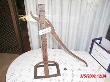 Friends of Kurth Kiln
Jinker Jack, Jack for changing wheels on light horse-drawn wagons. Contoured lever handle with holding ratchet, 1940 approx
... Jack for changing wheels on light horse-drawn wagons. Contoured Lever Handle with holding Ratchet...Contoured lever handle with holding ratchet Jinker Jack ...Jack for changing wheels on light horse-drawn wagons. Contoured Lever Handle with holding Ratchet -
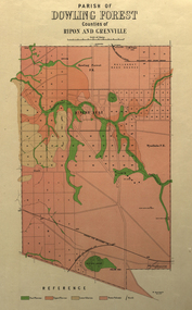 Federation University Historical Collection
Plan, Parish of Dowling Forest, County of Ripon and Grenville, 19
... Relief shown by contours....Relief shown by contours. Parish of Dowling Forest, County of Ripon and Grenville Plan Department of Crown Lands and Survey ...Scale [1:31 680]. 40 chains to 1 in.Geological map on a cadastral base, showing the occurence of reefs, and alluvial deposits. Relief shown by contours.dowling forest, wyndholm, wyndholm pre-emptive right, miners rest, ballarat racecourse, winter's swamp, police reserve, miner's rest, winters swamp, geology -
 Sunshine and District Historical Society Incorporated
Map - Board of Works Map No 19 C1933 Sunshine Station to St. Albans
... Albans including contour lines...Albans including contour lines Map Board of Works Map No 19 C1933 Sunshine Station to St. ...Board of Works Map No 19 C1933board of works -
 B-24 Liberator Memorial Restoration Australia Inc
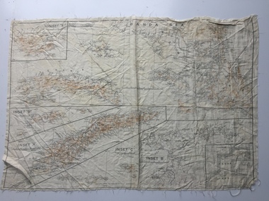
Map - Australian World War II silk map of Banda Sea, 1940s
... An oblong, cream colour, single-sided map printed in black and white with brown contours, Banda Sea ...This silk map, one of relatively few produced in Australia (most Australian RAAF pilots and crew were issued with British and US maps), is an original map from World War II. world war ii silk maps australia a186 Banda Sea (with Insets 'A' to 'E') An oblong, cream colour, single-sided map printed in black and white with brown contours, Banda Sea Map Australian World War II silk map of Banda Sea ...Silk and rayon maps were produced by Australia, Great Britain (some 1.75 million in total) and the United States (c.7.5 million) during World War II. They were issued to Allied military personnel as part of 'escape and evasion' kits.This silk map, one of relatively few produced in Australia (most Australian RAAF pilots and crew were issued with British and US maps), is an original map from World War II.An oblong, cream colour, single-sided map printed in black and white with brown contours, Banda Sea Banda Sea (with Insets 'A' to 'E')world war ii, silk maps, australia, a186 -
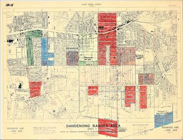 Ringwood and District Historical Society
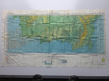
Map - State Aerial Survey, Dandenong Ranges Area Sheet 7, Parishes of Warrandyte, Scoresby, Ringwood and Nunawading - 1956
... Scale: 10 chains to 1 inch. Contour interval 20 feet. ...Scale: 10 chains to 1 inch. Contour interval 20 feet. Map of central and southern areas of Ringwood and part of Ringwood East and Heathmont compiled by Dept of Lands and Survey, July 1956, from aerial photographs and Cadastral Survey information. ...Map of central and southern areas of Ringwood and part of Ringwood East and Heathmont compiled by Dept of Lands and Survey, July 1956, from aerial photographs and Cadastral Survey information. Subsequent coloured hand-drawn additions showing layout of a number of post-NSW Separation era proposed subdivisions that did not eventuate, including Village of Studley Estate, Township of East Kew Estate, Township of Ballyduffy Estate, Township of New Flemington Estate, Township of East Hawthorne Estate. Ringwood A4B2, 849 A4B Zone 7. Scale: 10 chains to 1 inch. Contour interval 20 feet.