Showing 238 items matching "corner tower"
-
 Glen Eira Historical Society
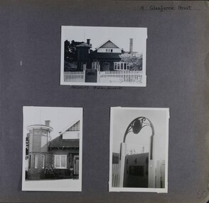
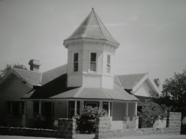
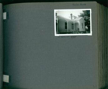
Album - Album page, Glenferrie Street, 4, Circa 1972
... ...corner tower...There is a octagonal corner tower with saucer shaped domed roof surmounted by a weather vane, and the tower has decorative terracotta panels immediately below the eaves line. ...This photograph is part of the Caulfield Historical Album 1972. This album was created in approximately 1972 as part of a project by the Caulfield Historical Society to assist in identifying buildings worthy of preservation. The album is related to a Survey the Caulfield Historical Society developed in collaboration with the National Trust of Australia (Victoria) and Caulfield City Council to identify historic buildings within the City of Caulfield that warranted the protection of a National Trust Classification. Principal photographer thought to be Trevor Hart, member of Caulfield Historical Society. Most photographs were taken between 1966-1972 with a small number of photographs being older and from unknown sources. All photographs are black and white except where stated, with 386 photographs over 198 pages. From Glen Eira Heritage Management Plan 1996 by Andrew Ward: In 1905, most of portion 27 was vacant land, however Glenferrie Street had been formed and the land subsequently subdivided. In 1906, Robert Joseph Haddon, architect and painter, designed and built for his private residence, a brick house on the west side. Haddon named the house "Anselm". Also built on the property were a garage and fibro cement studio. "Anselm" is architecturally important at the State level as a substantially intact, highly personalised and boldly expressed house expressive the Arts and Crafts movement and incorporating Art Nouveaux enrichment in a variety of forms, the use of ornamental terra cotta tiles to the comer tower being of special note. Its importance at the State level is strengthened by its place as the home of the noted architect and Melbourne's most influential exponent (Freeland, J.M., Architecture in Australia, p. 213) of the Art Nouveaux movement.https://vhd.heritagecouncil.vic.gov.au/places/4442 Victorian Heritage Register: What is significant? Anselm was designed by noted English born architect Robert Joseph Haddon(1866-1929) as his own house and constructed in 1906. A single storey Arts and Crafts influenced red brick house with attic, Anselm has a pyramidal slate roof with prominent chimney stacks. There is a octagonal corner tower with saucer shaped domed roof surmounted by a weather vane, and the tower has decorative terracotta panels immediately below the eaves line. The front door opens immediately into a large living or common room, screened from view by a timber and bottle glass screen. The large room was designed to function as a drawing and dining room. The house is rich with hand crafted details including door and window furniture, wrought iron gutter brackets, fireplaces (one with built in wood box), and fire tools. The interior decoration includes hand painted frieze of Port Phillip in the study, and a hand painted frieze of turbulent sea with sailing boats in the tiled bathroom. There is a small hand painted tile at the base of the tower which states ?This building was erected AD1906 from designs by Robt J Haddon FRIBA,Lond FRIVA Melb Architect?. He also designed an attic addition which was constructed in 1927. Anselm is substantially intact although the double casement window immediately to the south of the front door was originally circular....Page 60 of Photograph Album with three exterior photographs (one portrait and two landscape) of Anselm.Hand written: 4 Glenferrie Street [top right] / ANSELM 4 Glenferrie St [under top photo] / 60 [bottom right] trevor hart, anselm, art nouveaux, arts and crafts, tower, bay window, glenferrie street, robert joseph haddon, 1900's, terra cotta tiles, double storey, caulfield north, corner tower, gates, cast iron work -
 Glen Eira Historical Society
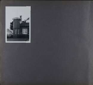
Album - Album page, Glenferrie Street, 4, Circa 1972
... ...corner tower...There is a octagonal corner tower with saucer shaped domed roof surmounted by a weather vane, and the tower has decorative terracotta panels immediately below the eaves line. ...This photograph is part of the Caulfield Historical Album 1972. This album was created in approximately 1972 as part of a project by the Caulfield Historical Society to assist in identifying buildings worthy of preservation. The album is related to a Survey the Caulfield Historical Society developed in collaboration with the National Trust of Australia (Victoria) and Caulfield City Council to identify historic buildings within the City of Caulfield that warranted the protection of a National Trust Classification. Principal photographer thought to be Trevor Hart, member of Caulfield Historical Society. Most photographs were taken between 1966-1972 with a small number of photographs being older and from unknown sources. All photographs are black and white except where stated, with 386 photographs over 198 pages. From Glen Eira Heritage Management Plan 1996 by Andrew Ward: In 1905, most of portion 27 was vacant land, however Glenferrie Street had been formed and the land subsequently subdivided. In 1906, Robert Joseph Haddon, architect and painter, designed and built for his private residence, a brick house on the west side. Haddon named the house "Anselm". Also built on the property were a garage and fibro cement studio. "Anselm" is architecturally important at the State level as a substantially intact, highly personalised and boldly expressed house expressive the Arts and Crafts movement and incorporating Art Nouveaux enrichment in a variety of forms, the use of ornamental terra cotta tiles to the comer tower being of special note. Its importance at the State level is strengthened by its place as the home of the noted architect and Melboume's most influential exponent (Freeland, J.M., Architecture in Australia, p. 213) of the Art Nouveaux movement. Victorian Heritage Register https://vhd.heritagecouncil.vic.gov.au/places/4442 What is significant? Anselm was designed by noted English born architect Robert Joseph Haddon(1866-1929) as his own house and constructed in 1906. A single storey Arts and Crafts influenced red brick house with attic, Anselm has a pyramidal slate roof with prominent chimney stacks. There is a octagonal corner tower with saucer shaped domed roof surmounted by a weather vane, and the tower has decorative terracotta panels immediately below the eaves line. The front door opens immediately into a large living or common room, screened from view by a timber and bottle glass screen. The large room was designed to function as a drawing and dining room. The house is rich with hand crafted details including door and window furniture, wrought iron gutter brackets, fireplaces (one with built in wood box), and fire tools. The interior decoration includes hand painted frieze of Port Phillip in the study, and a hand painted frieze of turbulent sea with sailing boats in the tiled bathroom. There is a small hand painted tile at the base of the tower which states ?This building was erected AD1906 from designs by Robt J Haddon FRIBA,Lond FRIVA Melb Architect?. He also designed an attic addition which was constructed in 1927. Anselm is substantially intact although the double casement window immediately to the south of the front door was originally circular....Page 61 of Photograph Album with one exterior photograph (portrait) of Anselm.Hand written: 61 [bottom left] trevor hart, anselm, art nouveaux, arts and crafts, tower, bay window, glenferrie street, robert joseph haddon, 1900's, terra cotta tiles, double storey, caulfield north, corner tower, brick house, attics -
 Glen Eira Historical Society
Historical Caulfield to 1972, photo album by Jenny O’Donnell, Normanby St
... 1 photo of a corner tower house...Glen Eira Historical Society 965 Glen Huntly Rd Caulfield VIC 3162 melbourne Caulfield East Normanby St Houses O’Donnell Jenny 1 photo of a corner tower house Historical Caulfield to 1972, photo album by Jenny O’Donnell, Normanby St ...1 photo of a corner tower housecaulfield east, normanby st, houses, o’donnell, jenny -
 Bendigo Historical Society Inc.
Photograph - PALL MALL, BENDIGO
... Post Office on corner with clock tower....Post Office on corner with clock tower. Photograph PALL MALL, BENDIGO ...Pall Mall view Bendigo. Post Office on corner with clock tower.unknownbendigo, council -
 Port Fairy Historical Society Museum and Archives
Photograph
... St John's Church North west corner complete with tower...Port Fairy Historical Society Museum and Archives 30 Gipps Street Port Fairy great-ocean-road St John's Church North west corner complete with tower church sunday-school building Black and white photograph Photograph Photograph ...St John's Church North west corner complete with towerBlack and white photographchurch, sunday-school, building -
 Canterbury History Group
Photograph - Canterbury Road view of the Canterbury Mansions at No. 208 Canterbury Road, Jan Pigot, 1994
... Also depicts the corner roof tower and the sold sign after the auction of the building....Also depicts the corner roof tower and the sold sign after the auction of the building. ...Coloured photograph of the Canterbury Road view of the 3 storey Victorian Building called Canterbury Mansions. Also depicts the corner roof tower and the sold sign after the auction of the building.canterbury, canterbury road, shops, victorian architecture, signs -
 Surrey Hills Historical Society Collection
Photograph, 'Garmure', 26 Russell Street, Surrey Hills in 1988
... This photo was taken after renovation of the rear of the house when the corner tower was added. Occupants: 1890: Mr Caffin 1910: Miss Agnes Campbell Hutchinson Orr 1930 – 1988: Sextons Miss Orr was born in Hutchesontown, Glasgow to Francis Orr (1834-1859) and Jane McDonald. ...This photo was taken after renovation of the rear of the house when the corner tower was added. Occupants: 1890: Mr Caffin 1910: Miss Agnes Campbell Hutchinson Orr 1930 – 1988: Sextons Miss Orr was born in Hutchesontown, Glasgow to Francis Orr (1834-1859) and Jane McDonald. ...‘Garmure’, 26 Russell Street, Surrey Hills was built c. 1887 and renovated c1988. This photo was taken after renovation of the rear of the house when the corner tower was added. Occupants: 1890: Mr Caffin 1910: Miss Agnes Campbell Hutchinson Orr 1930 – 1988: Sextons Miss Orr was born in Hutchesontown, Glasgow to Francis Orr (1834-1859) and Jane McDonald. Her father died soon after her birth and her mother married Thomas Blood. She had a half-brother Robert McDonald Blood. In 1903 she, her brother and mother were living in Boundary Road. She is buried with them in Kew Cemetery. She died aged 57 on 1 December 1926. A black and white photograph of a Queen Anne Style weatherboard house with a return veranda. The roof is corrugated iron. There is a picket fence along the front and a driveway on the left had side of the building.garmure, house names, (mr) - caffin, sexton family, queen anne style, corrugated iron, weatherboard, russell street, surrey hills, (miss) agnes campbell hutchinson orr -
 Surrey Hills Historical Society Collection
Photograph, Surrey Hills Reservoir No 1
... This is Surrey Hills Reservoir No 1 on the corner of Tower Street built in c1892 at a cost of £12,000 to supply higher sections of the area. ...This is Surrey Hills Reservoir No 1 on the corner of Tower Street built in c1892 at a cost of £12,000 to supply higher sections of the area. ...Copied by Ken Hall from an early postcard. This is Surrey Hills Reservoir No 1 on the corner of Tower Street built in c1892 at a cost of £12,000 to supply higher sections of the area. The builders were Jack and Bob Laudehr, partners in a wood yard in St. Kilda (Vic). They began by delivering firewood but extended to contract work involving timber. Another of their projects was to lay cable tram tracks commencing in Acland Street St. Kilda and running along The Esplanade. The reservoir in Canterbury Road was a large concrete structure built before the introduction of reinforcements. The excavated material was banked against the sides and pine trees were planted in it to add strength to the embankment. They were paid £2,000 for their work. Construction of Surrey Hills Number 2 Reservoir was completed in 1913 and the accompanying tower was built in 1929. It is assumed that the Miss Hill as the source of the donation (via Bill Dempsey) was Ivy Annie Hill (1902-1984). She was the only female child of William Valentine Dempsey to not marry. Bill Dempsey's mother was Laura Constance 'Birdie' Hill (1900-1968) who married Albert Dempsey.A sepia photograph within a post card of a reservoir on Canterbury Road, Surrey Hills. In the background to the left you can see the top halves of two houses and the tops of some trees. The photo takes up only the central section of the postcard.Below the photo on the front of the postcard on blue biro "Reservor [sic] Canterbury Rd / Surrey Hills." On the rear in grey lead pencil in Jocelyn Hall's handwriting: "Donor W Dempsey ------------- Keep / (nephew) / [arrow pointing down] / From Miss Hill / 10 Pembroke St SH / This house can be / seen in front of / No 12 which has / tower"1890, water supply, mmbw, edward d dyer (mr), 10 pembroke street, 12 pembroke street, surrey hills, ivy annie hill (miss), william valentine hill (mr), canterbury road, tower street, water supply structures and establishments, dams and reservoirs, jack laudehr (mr), bob laudehr (mr) -
 Bendigo Historical Society Inc.
Photograph - ESTELLE HEWSTON COLLECTION: COLOUR PHOTOGRAPHS OF THE BENDIGO POST OFFICE BUILDING, PALL MALL BUILDING, Sept 1990
... Two colour photographs of the exterior of the Bendigo Post Office Building, corner of Pall Mall and Sydney Myer Place, Bendigo Photos dated September 1990. 26A Exterior view of former Bendigo Post Office looking toward southerly aspect of building. 26B Exterior view of former Bendigo Post Office from corner of Williamson Street and Pall Mall. Note clock tower on corner of building....Post Office Bendigo Pall Mall Estelle Hewston Two colour photographs of the exterior of the Bendigo Post Office Building, corner of Pall Mall and Sydney Myer Place, Bendigo Photos dated September 1990. 26A Exterior view of former Bendigo Post Office looking toward southerly aspect of building. 26B Exterior view of former Bendigo Post Office from corner of Williamson Street and Pall Mall. Note clock tower on corner of building. ...Two colour photographs of the exterior of the Bendigo Post Office Building, corner of Pall Mall and Sydney Myer Place, Bendigo Photos dated September 1990. 26A Exterior view of former Bendigo Post Office looking toward southerly aspect of building. 26B Exterior view of former Bendigo Post Office from corner of Williamson Street and Pall Mall. Note clock tower on corner of building.Estelle Hewstonpost office, bendigo, pall mall -
 Bendigo Historical Society Inc.
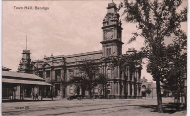
Postcard - CARWARDINE COLLECTION: TOWN HALL BENDIGO
... On top LH corner 'Town Hall, Bendigo'. Image shows two storey Town Hall building with clock tower. ...On top LH corner 'Town Hall, Bendigo'. Image shows two storey Town Hall building with clock tower. ...Black and white postcard. On top LH corner 'Town Hall, Bendigo'. Image shows two storey Town Hall building with clock tower. Corner of Market Building on LH side. Early motor vehicle ( 1920's) in front of building. Written on back of card ' 1926, Dear Alf, just a line to say that we were very pleased hearing that you got back safely. The flowers arrived in good order. I was very pleased to get them. We were surprised to see that you had such a variety of carnations, sweet peas and marguerites also were very (illegible) Mother does not seem nearly so well she is certainly getting weaker, doctor was up again today, he said he could not prescribe anything different to what she is taking to keep up her strength' Card not signed. Receipt number 355/16bendigo, business, carwardine soap and candle -
 Bendigo Historical Society Inc.
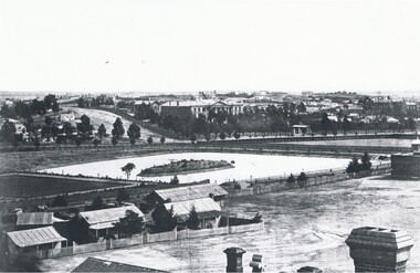
Photograph - LANDSCAPE VIEW OF BENDIGO
... Lake or dam with small island centre, stone brick wall with lookout tower at corner ( Bendigo gaol ) at right centre distanc,e large building. ...Lake or dam with small island centre, stone brick wall with lookout tower at corner ( Bendigo gaol ) at right centre distanc,e large building. ...Black and white photograph. In foreground, roof and chimneys. Row of 3 small weatherboard houses with verandah, picket fences. 1 small and 1 larger building behind. Lake or dam with small island centre, stone brick wall with lookout tower at corner ( Bendigo gaol ) at right centre distanc,e large building. Benevolent Asylum. Many other buildings in distance. James Lerk 11.2.2000 ' view from the Corporate High School, Benevolent Asylum in centre' Unknown BHS member 5.11.1999 ' lower dam ( site of present tennis courts, Park Road, pumped out C 1926' Written on back of photo 'Bendigo Victoria 1860's, Sandhurst North view 100 miles north from Melbourne. C. Nettleton, Victorian Views'C. Nettleton ?place, landscape view, bendigo -
 Warrnambool and District Historical Society Inc.
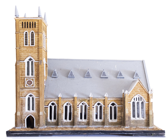
Artefact, Model of Church, C1900
... tower is square-shaped with four conical-shaped finials. The upper part has four sets of louvres and two arched windows. The centre and lower sections have rosette patterns and several sets of dual arched windows with frosted decorated glass panels. The north east corner...tower is square-shaped with four conical-shaped finials. The upper part has four sets of louvres and two arched windows. The centre and lower sections have rosette patterns and several sets of dual arched windows with frosted decorated glass panels. The north east corner ...This model of St. John’s Presbyterian Church in Warrnambool was made by Johan Carl August Landmann (1826-1920). August Landmann and his wife, Christina came from Silesia to Australia in 1854. They settled in Warrnambool where August made a living as a carpenter and joiner. At first he rented shops in Timor Street and then built a two-storeyed shop and residence in Henna Street. Landmann built many of the early commercial buildings and residences in Warrnambool and he and his family were associated with the management of the Warrnambool Western Brewery. When he retired in 1900 he built another residence in Mickle Street and it was at that time that it is believed he made the model of the Presbyterian Church and the model of the Ozone Hotel (which is in the Warrnambool Art Gallery today). St. John’s Presbyterian Church, designed by Andrew Kerr, was built in the English Gothic style and opened in 1875. It was destroyed by fire in 1920 but was rebuilt to a similar style. This model is of great significance for two reasons: 1. It was made by a prominent early Warrnambool carpenter and joiner, Johan Carl August Landmann. 2. It is the only known model of the Warrnambool St. John’s Presbyterian Church which was destroyed by fire in 1920.This model is on a wooden stand or base which is painted black with metal screws. The edging of the stand contains straw which is now brown but was originally green to resemble grass or lawn. The church is a wooden structure (hollow inside) with some sections painted to resemble sandstone. The roof is slanted and painted grey and has six dormer windows or ventilation pieces on each side. The main body of the church has a nave with dual arched windows, the west end has dual arched windows and a door with louvre ventilation and the east end has a door and dual arched windows and two conical-shaped finials. The windows, some of which are triangular, have frosted decorated glass. Some of the glass in the windows is missing. The main tower is square-shaped with four conical-shaped finials. The upper part has four sets of louvres and two arched windows. The centre and lower sections have rosette patterns and several sets of dual arched windows with frosted decorated glass panels. The north east corner has a smaller tower.johan carl august landmann, st. john’s presbyterian church, warrnambool, warrnambool history -
 Warrnambool and District Historical Society Inc.
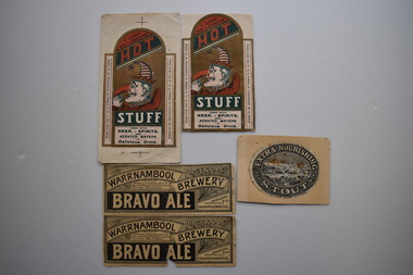
5x Labels, Hodgens, Early 20th century
... Tower Hill .This is surrounded by a wide border containing text. The label is discoloured .2,.3 Dark cream paper rectangular labels with black and white text. There are decorations of berries and leaves in one corner...Tower Hill .This is surrounded by a wide border containing text. The label is discoloured .2,.3 Dark cream paper rectangular labels with black and white text. There are decorations of berries and leaves in one corner ...These labels come from the Brewery of Hodgens & Co. who operated the Warrnambool Brewery west of the corner of Timor and Banyan Streets This brewery was established by Edmund Wheeler as the Western Brewery in 1866. Daniel Hodgens the principal of Hodgens & Co. owned the Warrnambool Brewery from sometime in the 1890s until 1909. (Hodgens died in 1907.) Daniel Hodgens also owned the National Hotel and the Pieter Both Hotel and leased the Union, Princess Royal, Prince of Wales and the Bayview hotels in the late 1890s.These labels are of considerable interest as they are artistically pleasing and are part of an important brewery business in Warrnambool in times past. .1 Oval grey and white label adhered to a piece of cream coloured card. It has a sketch of a lake and hills in the centre which resembles Tower Hill .This is surrounded by a wide border containing text. The label is discoloured .2,.3 Dark cream paper rectangular labels with black and white text. There are decorations of berries and leaves in one corner. The primary texts are contained in two long arcs and a black rectangle. Both labels are torn. .2 has a section missing. .4,.5 Rectangular labels with a curved top and extended side panels. It features,on a gold coloured background, the profile of Punch wearing a crown with a striped red and white stocking attachment. Punch has a long hooked red nose and is raising a flask towards his mouth. Above him in the curved top section are two diagonal red and dark green panels containing text. Underneath Punch are two rectangular wide, dark green and white panels containing text. The extended side panels are at right angles to the central section.There are two crosses on the top and bottom of .5 The section containing these and also a sections beside the side extensions have been removed from .4. .1EXTRA NOURISHING STOUT HODGENS & CO WARRNAMBOOL .2,.3 HODGENS & CO. WARRNAMBOOL BREWERY BRAVO ALE Refreshing, Invigorating and Contstiting (sic.) an Appetising Tonic while slightly Stimulating. Easy of Digestion HODGENS & CO PROPRIETORS WARRNAMBOOL .4,.5 A CERTAIN CURE FOR INDIGESTION HOT STUFF USED WITH BEER SPIRITS AND AERATED WATERS A DELICIOUS DRINK . Bottled for the Manufacturers by Hodgens & Co. at their Spirits Stores. . warrnambool brewery 1885-1909 -
 Bendigo Military Museum
Postcard - POSTCARD - CODFORD UK, YMCA, 1. 9 May 1918. 2. 13 July 1918. 3. 1 September 1918
... Corner. 2. Collation of black and white photographs of scenes from a village. 3. Coloured photograph of a group of soldiers in winter uniform and standing on a snow covered road. Buildings in background. 4. Black and white photograph of a church with square tower...Corner. 2. Collation of black and white photographs of scenes from a village. 3. Coloured photograph of a group of soldiers in winter uniform and standing on a snow covered road. Buildings in background. 4. Black and white photograph of a church with square tower ...Postcards sent by R.H. Baron depicting scenes of Codford when the AIF was encamped during WW1. Part of the Robert H. Baron, No. 3596 and Cooper Collections. See Catalogue No. 1981P for details of Baron's service.1. Plain postcard with no photograph. Front has printed Mother's Day message. Y.M.C.A. logo and Rising Sun badge printed at top. Space for written address. Postmark top R.H. Corner. 2. Collation of black and white photographs of scenes from a village. 3. Coloured photograph of a group of soldiers in winter uniform and standing on a snow covered road. Buildings in background. 4. Black and white photograph of a church with square tower, Houses next door. Graveyard next to church. 5. Black and white photograph of a Rising Sun badge carved into a hill side.1. Handwritten in black ink on back: 'Letter to R.H. Baron's mother, dated 9 May 1918'. 2. Greetings from Codford. Handwritten in black ink on back: Letter to R.H. Baron's mother dated 13 July 1918. 3. Winter at Codford. Handwritten in black ink on back: 'Letter from R.H. Baron to Doris dated 1 September 1918'. 4. Codford, St Mary Church. Handwritten in black ink on back: This is a church in the centre of our camp. Bob'. 5. The Rising Sun, Codford. Handwritten in black ink on back: 'Dear Elsie, This Rising Sun was made by an Australian Soldier some time back. Bob'. robert h. baron, cooper collection, postcards, codford uk, aif camp - ww1 -
 Christ Church Anglican Parish of Warrnambool
Memorial Plaque: Frederick Stephen STEVENS, CG Roeszler Sc Melbourne; WJ Hickford Warrnambool, Late 19th Century
... Corner of Koroit Street and Henna Street Warrnambool great-ocean-road The bells presented to Christ Church were brought to Melbourne for the 1881 Melbourne Exhibition where they were awarded 1st prize. Frederick Perkins Stevens several years later also provided the three stained glass windows above the main altar within the church as a memorial to his first wife, Jane, FS Stevens' mother. The plaque acknowledges the loss of a son, the provision of the three bells and the status of the donor. fp stevens fs stevens german bells german bells melbourne exhibition 1881 The Three Bells erected / in this Tower ...The bells presented to Christ Church were brought to Melbourne for the 1881 Melbourne Exhibition where they were awarded 1st prize. Frederick Perkins Stevens several years later also provided the three stained glass windows above the main altar within the church as a memorial to his first wife, Jane, FS Stevens' mother.The plaque acknowledges the loss of a son, the provision of the three bells and the status of the donor.Ornately decorated, coloured and inscribed brass plaque within an oak frame. Red and blue colouring within the design elements and lettering.The Three Bells erected / in this Tower were / presented to Christ Church warrnambool by FP Stevens / Member for Villiers & Heytesbury / of the Legislative Council of / Victoria 1852 / In Memory of his younger Son / FS Stevens who died at his Station / Tintinchilla Queensland / 26th May 1880 Aged 30 Yearsfp stevens, fs stevens, german bells, german bells melbourne exhibition 1881 -
 Christ Church Anglican Parish of Warrnambool
Memorial window: Elizae (Eliza) RUTLEDGE, "By Thy Glorious Ascension Good Lord Deliver Us"
... Corner of Koroit Street and Henna Street Warrnambool great-ocean-road Eliza Rutledge (1820-1888) was the daughter of Rupert and Jane (nee Newby) Kirk. She married William Rutledge in St James’ Church, Sydney on 18th August, 1840. She and William had five children, two sons and five daughters. Recorded accounts tell that Eliza was “beloved for her kindness and hospitality” and that she and William kept open house for all manner of social events and occasions. Eliza died at Farnham Park, Dennington, on 31st August 1888. She is buried at Tower ...Eliza Rutledge (1820-1888) was the daughter of Rupert and Jane (nee Newby) Kirk. She married William Rutledge in St James’ Church, Sydney on 18th August, 1840. She and William had five children, two sons and five daughters. Recorded accounts tell that Eliza was “beloved for her kindness and hospitality” and that she and William kept open house for all manner of social events and occasions. Eliza died at Farnham Park, Dennington, on 31st August 1888. She is buried at Tower Hill Cemetery. The marriage of Eliza to William Rutledge, a man of historical importance in the development of Port Fairy, Warrnambool and the western district of Victoria, places her as a person of importance.Their daughter Susan Fleetwood is also memorialised in a window in Christ Church, Warrnambool. Their son Thomas Forster is also memorialised with a tablet positioned near the Eliza Rutledge windows. Stained glass, lancet window, south wall, main nave. Depiction of the ascension of Christ."By Thy Glorious Ascension Good Lord Deliver Us" In Latin: +In Memoriam+ Elizae Rutledge quae pridie idus Februarias/ MDCCXX nata pridie kalendas Septembres MDCCCXXXVIII obit/ liberi amantissimi Gulielmus Rutledge et Susanna Fleetwood pietatis/ indicio hane Jenestram posuerant Beati qui sunt mundi corde.rutledge, christ church warrnambool, eliza rutledge, eliza kirk, farnham park -
 Kiewa Valley Historical Society
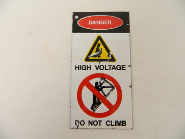
Sign - S.E.C.V. x5
... Their towers and switch boards had high voltage equipment. secv. kiewa hydro electric scheme. electricity. sign. Danger / High Voltage / Do Not Climb Red, white, black and yellow steel sign with a circular hole at the top left hand corner. ...The State Electricity Commission of Victoria used signs to warn people of danger when near high voltage equipment.The S.E.C.V. built the Kiewa Hydro Electric Scheme from the late 1940s. Their towers and switch boards had high voltage equipment.Red, white, black and yellow steel sign with a circular hole at the top left hand corner. Used to warn people of danger near high voltage equipment. The back is white.Danger / High Voltage / Do Not Climbsecv. kiewa hydro electric scheme. electricity. sign. -
Kiewa Valley Historical Society
S.E.C. Hydroline Newsletters x 10
... Miscellaneous number 1981-1986 of the monthly newsletter with several pages stapled at the top left hand corner. 1981 has 2 red small towers joined with title in the middle. ...During the 1980s, communication was encouraged between the SEC working groups as their roles became more remote from each other. hydroline newsletter sec newsletter sec workers at kiewa Miscellaneous number 1981-1986 of the monthly newsletter with several pages stapled at the top left hand corner. 1981 has 2 red small towers joined with title in the middle. ...Newsletter 'Hydroline' relied on a variety of contributions from Rubicon and Kiewa Groups. Each group was encouraged to write in the section "Getting to Know Ourselves". During the 1980s, communication was encouraged between the SEC working groups as their roles became more remote from each other.Miscellaneous number 1981-1986 of the monthly newsletter with several pages stapled at the top left hand corner. 1981 has 2 red small towers joined with title in the middle. The 1982 - 1984 have SEC logo top centre with McKay Pipeline drawn underneath and title between the two.hydroline newsletter, sec newsletter, sec workers at kiewa -
 Port of Echuca
Postcard, Early 20th Century
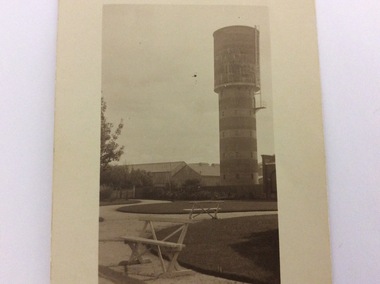
... The water tower on the corner of Pakenham St and High Street Echuca, was designed by Sir John Monash, who was an innovator in the use of reinforced concrete. ...Port of Echuca 74 Murray Esplanade Echuca the-murray The water tower on the corner of Pakenham St and High Street Echuca, was designed by Sir John Monash, who was an innovator in the use of reinforced concrete. ...The water tower on the corner of Pakenham St and High Street Echuca, was designed by Sir John Monash, who was an innovator in the use of reinforced concrete. The tower cost £2,973 and was completed in 1915. It is 108 feet high and holds 150,000 gallons. it was originally connected to the steam powered pumping plant at Echuca East. John Monash was a war hero at Gallipoli in 1915 and also went on to be the Manager of the Victorian State Electricity Commission. Monash University was named after him.The water tower was a revolutionary design in 1915. It also brought tapped water to people's homes. Sir John Monash made a huge contribution to engineering and social concepts, which was why he was knighted. As well as these contributions to social development, he was also a war hero.Black and white postcard featuring the water tower in Packenham Street. The photograph was taken from Alton Reserve. The background shows a conglomeration of buildings and the foreground shows shaped lawns and park benches. The postcard has a thick border in a cream colour all around it.On the reverse is printed ; POST CARD. Write here for Inland Postage only. Tha Address to be written here. In pen is hand written the words View of Water Tower Pakenham St. Taken from Alton Reserve?echuca east pumping station, echuca water tower, monash, sir john, alton reserve, engineering, reinforced concrete -
 Port of Echuca
Colour photograph, Approx. 1979
... The old Echuca Post Office was built circa 1877, a two-storey stucco building with a clock tower over the entrance, on the north east corner of Hare and Anstruther streets. ...Port of Echuca 74 Murray Esplanade Echuca the-murray The old Echuca Post Office was built circa 1877, a two-storey stucco building with a clock tower over the entrance, on the north east corner of Hare and Anstruther streets. ...The old Echuca Post Office was built circa 1877, a two-storey stucco building with a clock tower over the entrance, on the north east corner of Hare and Anstruther streets. In the front of the building is a small cream brick kiosk used as a bus stop and as a stall for charity group's to sell produce. On the far northern corner the spire of St.Mary's church can be seen above the roof of the Post Office.The old Echuca Post office is at the northern end of the shopping precinct in Hare street Echuca. The building is a beautiful grand building of the late 1870's which was built as a post office on the ground floor and a residence above. The small kiosk building in front of the post office was used by volunteer organisations to raise money selling cakes etc. at various times of the year.Colour photograph (post card size) of Echuca Post Office looking north. The post office was built circa 1877, a two storey building with a clock tower over the entrance door. In front of the building is a small cream brick kiosk and bus shelter.Printed on the reverse "this paper manufactured by Kodak"echuca post office, echuca-historical buildings -
 Port of Echuca
Colour Photograph, Approx.1979
... The water tower on the corner of Pakenham St and High Street Echuca, was designed by Sir John Monash, who was an innovator in the use of reinforced concrete. ...Colour photograph of water tower on the south east corner of High and Pakenham street, Echuca. ...Printed on the reverse:" this paper manufactured by Kodak" Colour photograph of water tower on the south east corner of High and Pakenham street, Echuca. ...The water tower on the corner of Pakenham St and High Street Echuca, was designed by Sir John Monash, who was an innovator in the use of reinforced concrete. The tower cost £2,973 and was completed in 1915. It is 108 feet high and holds 150,000 gallons. it was originally connected to the steam powered pumping plant at Echuca East. John Monash was a war hero at Gallipoli in 1915 and also went on to be the Manager of the Victorian State Electricity Commission. Monash University was named after him.The water tower was a revolutionary design in 1915., being constructed of reinforced concrete. It also brought tapped water to people's homes. Sir John Monash made a huge contribution to engineering and social concepts, which was why he was knighted. As well as these contributions to social development, he was also a war hero. Colour photograph of water tower on the south east corner of High and Pakenham street, Echuca. The St Andrews church tower can be seen in the background.On the front of the photograph on the bottom facade of the water tower is painted "E.W.T." (Echuca Water Trust). Printed on the reverse:" this paper manufactured by Kodak"echuca, water tower, echuca-historical buildings, monash, sir john, reinforced concrete building construction -
 Orbost & District Historical Society
sheet music, Under the Bridges of Paris, first half 20th century
... Tower and the Arc de Triomphe. In the centre is a head and shoulders photograph of a man in a suit and tie. It is captioned "Recorded by Rene Paul on Columbia." Under the title are details of the composer and lyricists. In the bottom right corner...Tower and the Arc de Triomphe. In the centre is a head and shoulders photograph of a man in a suit and tie. It is captioned "Recorded by Rene Paul on Columbia." Under the title are details of the composer and lyricists. In the bottom right corner ...Under the Bridges of Paris" is a 1913 popular song with music written by Vincent Scotto, the original French lyrics (entitled "Sous les ponts de Paris") by Jean Rodor (1913), and English sections of lyrics added by Dorcas Cochran (1952) resulting in the released version (1954) containing both French and English sections. This version of the song was recorded by Rene Paul.The music has social significance as an example of music popular in the first half of the 20th century.Sheet music for "Under the bridges of Paris". The cover is blue with white illustrations of the Eiffel Tower and the Arc de Triomphe. In the centre is a head and shoulders photograph of a man in a suit and tie. It is captioned "Recorded by Rene Paul on Columbia." Under the title are details of the composer and lyricists. In the bottom right corner is the price 2/6.music-sheet under-the-bridges-of-paris -
 Eltham District Historical Society Inc
Photograph, Miner's Cottage, corner Main and Reynolds roads, Research, Vic, 1986
... corner of Main Road and Reynolds Road, Eltham. Wal and Bernie Dodkins, rented the house from around 1938 until they left in the 1970s to become caretakers at the Kangaroo Ground Tower. ...corner of Main Road and Reynolds Road, Eltham. Wal and Bernie Dodkins, rented the house from around 1938 until they left in the 1970s to become caretakers at the Kangaroo Ground Tower. ...Miner's Cottage, owned by Mrs Ivy Reynolds at the corner of Main Road and Reynolds Road, Eltham. Wal and Bernie Dodkins, rented the house from around 1938 until they left in the 1970s to become caretakers at the Kangaroo Ground Tower. Lyn Dodkins (wife of Graeme Hardiman) was born there and lived in this house for her first 19 years. [Graeme Hardiman email 5 Aug 2022] The site was developed for commercial use as the Eltham Motor Inn, which permanently closed about 2024 and has since been refurbished for use as rental units (2025).Six colour photographs of old cottage corner Main and Reynolds roads at Research in 1986. The cottage was built by/for Grandfather Reynolds and was demolished 2 Mar 1987. Three views show widening of Main Road.houses, main road, reynolds road, research (vic.), lyn dodkins, wal dodkins, bernie dodkins, miss reynolds, dodkins family, eltham, eltham motor inn, ivy reynolds, miner's cottage -
 Glen Eira Historical Society
Album - Album page, Fairfield Hall, 225 North Road, Circa 1972
... tower...bichromatic brickwork...fairfield hall...1890's...george jobbins...conical roofed projecting corner...Glen Eira Heritage Management Plan 1996 by Andrew Ward https://www.gleneira.vic.gov.au/media/4777/heritage_mment_plan_vol_3b.pdf (as of 27/01/2021) - p90 An imposing single storeyed Italianate bi-chromatic brick villa with three staged tower surmounting the entry and facetted corner bay with conical roof. ...Glen Eira Heritage Management Plan 1996 by Andrew Ward https://www.gleneira.vic.gov.au/media/4777/heritage_mment_plan_vol_3b.pdf (as of 27/01/2021) - p90 An imposing single storeyed Italianate bi-chromatic brick villa with three staged tower surmounting the entry and facetted corner bay with conical roof. ...This photograph is part of the Caulfield Historical Album 1972. This album was created in approximately 1972 as part of a project by the Caulfield Historical Society to assist in identifying buildings worthy of preservation. The album is related to a Survey the Caulfield Historical Society developed in collaboration with the National Trust of Australia (Victoria) and Caulfield City Council to identify historic buildings within the City of Caulfield that warranted the protection of a National Trust Classification. Principal photographer thought to be Trevor Hart, member of Caulfield Historical Society. Most photographs were taken between 1966-1972 with a small number of photographs being older and from unknown sources. All photographs are black and white except where stated, with 386 photographs over 198 pages. Glen Eira Heritage Management Plan 1996 by Andrew Ward https://www.gleneira.vic.gov.au/media/4777/heritage_mment_plan_vol_3b.pdf (as of 27/01/2021) - p90 An imposing single storeyed Italianate bi-chromatic brick villa with three staged tower surmounting the entry and facetted corner bay with conical roof. White tuckpointed black body bricks are relieved with reds and stucco work. Gable ends are fretted and there is a concave cast iron verandah to the principal elevations.Victorian Heritage Database (as of 27/10/2020) - HO49 225 North Road Caulfield South https://vhd.heritagecouncil.vic.gov.au/places/42426 "Maniar" (?) is a substantial late Victorian Italianate villa with tower and extensive grounds built for Frederick Curwan, an inspector of the National Bank, in 1890. It is aesthetically and historically important. An imposing single storeyed ltalianate bi-chromatic brick villa with three staged tower surmounting the entry and facetted comer bay with conical roof. White tuckpointed black body bricks are relieved with reds and stucco work. Gable ends are fretted and there is a concave cast iron verandah to the principal elevations. It is aesthetically important as an imposing and substantially intact villa residence demonstrating the changing architectural fashions of the 1890's, evidenced by the use of face brickwork and fretted gables in the Queen Anne manner. It is historically important for the manner in which it demonstrates the lifestyle to which a businessman could aspire during the boom period.Page 150 of Photograph Album with four landscape photographs of Fairfield Hall on North Road.Handwritten: "Fairfield Hall" 225 North Rd cnr Younger Ave [top right] / 150 [bottom right]trevor hart, jenny o'donnell, verandah, porch, tower house, tower, mansion, three storey tower, bichromatic brickwork, fairfield hall, 1890's, george jobbins, conical roofed projecting corner bay, conical roofed bay, timber ceilings, north road, younger avenue, frederick wallis curwan, curwan, italianate, queen anne, australian homestead, arched windows, curved windows, columned parapet, return verandah, fairfield estate, fairfield street, slate roofed, red brick, polychrome bricks, victorian style, cast iron work, caulfield south, maniar, house names -
 Glen Eira Historical Society
Album - Album page, Myoora, 405 Alma Road, Circa 1972
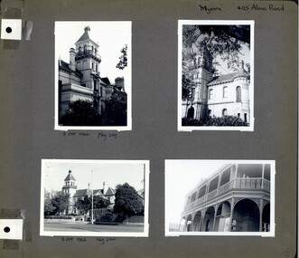
... Labassa, the most fabulous, is quite different stylistically as are most of the other comparable mansions. caulfield north trevor hart alma road mansion myoora tower lacework arched windows anketell henderson thomas christian 1880's cement rendered brick slate roof cast iron verandah cast iron balconies bluestone footings queen anne american romanesque bay windows boom style continental and english renaissance cast iron work reed henderson & smart flats gardens asymmetrical style Handwritten: "Myoora" 405 Alma Rd [top right hand corner] / 8 Oct 1966 Neg 229 [underneath top left photograph] / 8 Oct 1966 Neg 230 [underneath bottom left photograph] / 6 [bottom right] Page 6 of Photograph Album including four black and white photographs of the mansion Myoora. ...This photograph is part of the Caulfield Historical Album 1972. This album was created in approximately 1972 as part of a project by the Caulfield Historical Society to assist in identifying buildings worthy of preservation. The album is related to a Survey the Caulfield Historical Society developed in collaboration with the National Trust of Australia (Victoria) and Caulfield City Council to identify historic buildings within the City of Caulfield that warranted the protection of a National Trust Classification. Principal photographer thought to be Trevor Hart, member of Caulfield Historical Society. Most photographs were taken between 1966-1972 with a small number of photographs being older and from unknown sources. All photographs are black and white except where stated, with 386 photographs over 198 pages. Myoora - Victorian Heritage Register (VHR) Number H0490 https://vhd.heritagecouncil.vic.gov.au/places/275 Myoora, 405 Alma Road, North Caulfield, was designed by Reed, Henderson & Smart and can be attributed to Anketell Henderson. It was built in 1886 and 1887 for Thomas Christian, who had founded the fabled gold mine, the Day Dawn at Charters Towers. He never occupied the house although his widow lived there for some time. The house was subdivided into three and later six flats. Myoora was one of many large mansions on broad acres with gardens in Caulfield. Perhaps the grandest was Labassa. The mansions date from the 1850s through to the late 1890s. The siting of Myoora on a ridge influenced its planning and composition. A central hall and corridor along the ridge is entered from the centre of the more formal north facade. The entrance is marked by an elaborately detailed tower. A stair turret provides a second accent. The western end of the building is completed by a massively detailed chimney as the service wing. The south facade enjoyed an outlook to port phillip from a two-storey cast iron verandah. Bay windows, chimneys, the tower and the turret and minor details are brought together in a sophisticated asymmetrical composition. This is reflected in the planning. The asymmetry of Myoora pivoting on the tower is the most notable feature of the building. The walls are built of cement rendered brick. The cement render has not been painted. The roof is slate. The balconies and verandah are cast iron. The footings and cellar are bluestone. The architectural firm Reed, Henderson & Smart was very prominent in Victoria in the nineteenth century. Anketell Henderson was an eminent and well respected member of the profession. He worked successfully in London and interstate as well as in Victoria. They were better known for commercial and public buildings. Myoora is an important private commission. The style of Myoora is a combination of details from the Continental and English Renaissance through the boom style and the Queen Anne style. There is also an early influence from the American Romanesque style especially in the stair turret. The latter style was important at the turn of the century and Myoora is a significant precursor. Other buildings of a similar scale survive in Caulfield and elsewhere. Labassa, the most fabulous, is quite different stylistically as are most of the other comparable mansions.Page 6 of Photograph Album including four black and white photographs of the mansion Myoora. Two photographs in the top half of the page are in portrait orientation while the two photographs in the bottom half of the page are in landscape orientation.Handwritten: "Myoora" 405 Alma Rd [top right hand corner] / 8 Oct 1966 Neg 229 [underneath top left photograph] / 8 Oct 1966 Neg 230 [underneath bottom left photograph] / 6 [bottom right]caulfield north, trevor hart, alma road, mansion, myoora, tower, lacework, arched windows, anketell henderson, thomas christian, 1880's, cement rendered brick, slate roof, cast iron verandah, cast iron balconies, bluestone footings, queen anne, american romanesque, bay windows, boom style, continental and english renaissance, cast iron work, reed henderson & smart, flats, gardens, asymmetrical style -
 Glen Eira Historical Society
Album - Album page, Myoora, 405 Alma Road, Circa 1972
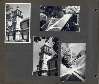
... Labassa, the most fabulous, is quite different stylistically as are most of the other comparable mansions. caulfield north trevor hart alma road mansion myoora tower thomas christian 1880's queen anne cement rendered brick unpainted balconies verandahs anketell henderson continental and english renaissance american romanesque views cast iron work reed henderson & smart flats gardens asymmetrical style slate roofs Handwritten: 007 (bottom left hand corner) Page 7 of Photograph Album including four black and white photographs. ...This photograph is part of the Caulfield Historical Album 1972. This album was created in approximately 1972 as part of a project by the Caulfield Historical Society to assist in identifying buildings worthy of preservation. The album is related to a Survey the Caulfield Historical Society developed in collaboration with the National Trust of Australia (Victoria) and Caulfield City Council to identify historic buildings within the City of Caulfield that warranted the protection of a National Trust Classification. Principal photographer thought to be Trevor Hart, member of Caulfield Historical Society. Most photographs were taken between 1966-1972 with a small number of photographs being older and from unknown sources. All photographs are black and white except where stated, with 386 photographs over 198 pages. Myoora - Victorian Heritage Register (VHR) Number H0490 https://vhd.heritagecouncil.vic.gov.au/places/275 Myoora, 405 Alma Road, North Caulfield, was designed by Reed, Henderson & Smart and can be attributed to Anketell Henderson. It was built in 1886 and 1887 for Thomas Christian, who had founded the fabled gold mine, the Day Dawn at Charters Towers. He never occupied the house although his widow lived there for some time. The house was subdivided into three and later six flats. Myoora was one of many large mansions on broad acres with gardens in Caulfield. Perhaps the grandest was Labassa. The mansions date from the 1850s through to the late 1890s. The siting of Myoora on a ridge influenced its planning and composition. A central hall and corridor along the ridge is entered from the centre of the more formal north facade. The entrance is marked by an elaborately detailed tower. A stair turret provides a second accent. The western end of the building is completed by a massively detailed chimney as the service wing. The south facade enjoyed an outlook to port phillip from a two-storey cast iron verandah. Bay windows, chimneys, the tower and the turret and minor details are brought together in a sophisticated asymmetrical composition. This is reflected in the planning. The asymmetry of Myoora pivoting on the tower is the most notable feature of the building. The walls are built of cement rendered brick. The cement render has not been painted. The roof is slate. The balconies and verandah are cast iron. The footings and cellar are bluestone. The architectural firm Reed, Henderson & Smart was very prominent in Victoria in the nineteenth century. Anketell Henderson was an eminent and well respected member of the profession. He worked successfully in London and interstate as well as in Victoria. They were better known for commercial and public buildings. Myoora is an important private commission. The style of Myoora is a combination of details from the Continental and English Renaissance through the boom style and the Queen Anne style. There is also an early influence from the American Romanesque style especially in the stair turret. The latter style was important at the turn of the century and Myoora is a significant precursor. Other buildings of a similar scale survive in Caulfield and elsewhere. Labassa, the most fabulous, is quite different stylistically as are most of the other comparable mansions.Page 7 of Photograph Album including four black and white photographs. Three photos are in a portrait orientation and placed diagonally across the page from the top left hand side to the bottom right hand side. One photograph in a landscape orientation is on the top right hand side of the page. Handwritten: 007 (bottom left hand corner)caulfield north, trevor hart, alma road, mansion, myoora, tower, thomas christian, 1880's, queen anne, cement rendered brick, unpainted, balconies, verandahs, anketell henderson, continental and english renaissance, american romanesque, views, cast iron work, reed henderson & smart, flats, gardens, asymmetrical style, slate roofs -
 Glen Eira Historical Society
Album - Album page, Myoora, 405 Alma Road, Circa 1972
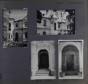
... The main staircase has been removed, minor alterations to decorative features have occurred and additions have been made to the exterior. caulfield north trevor hart alma road mansion myoora tower thomas christian 1880's queen anne cement rendered brick unpainted balconies verandahs anketell henderson continental and english renaissance american romanesque views cast iron work reed henderson & smart flats gardens asymmetrical style slate roofs entrances Handwritten: "Myoora" 405 Alma Rd [top right hand corner] / Neg 179 DEC 1972 [underneath bottom left photograph] / Neg 180 DEC 1972 [underneath bottom right photograph] / 8 [bottom right] Page 8 of Photograph Album including four black and white photographs. ...This photograph is part of the Caulfield Historical Album 1972. This album was created in approximately 1972 as part of a project by the Caulfield Historical Society to assist in identifying buildings worthy of preservation. The album is related to a Survey the Caulfield Historical Society developed in collaboration with the National Trust of Australia (Victoria) and Caulfield City Council to identify historic buildings within the City of Caulfield that warranted the protection of a National Trust Classification. Principal photographer thought to be Trevor Hart, member of Caulfield Historical Society. Most photographs were taken between 1966-1972 with a small number of photographs being older and from unknown sources. All photographs are black and white except where stated, with 386 photographs over 198 pages.Myoora - Victorian Heritage Register (VHR) Number H0490 https://vhd.heritagecouncil.vic.gov.au/places/275 (as at 6/10/2020) Myoora, 405 Alma Road, North Caulfield, was designed by Reed, Henderson & Smart and can be attributed to Anketell Henderson. It was built in 1886 and 1887 for Thomas Christian, who had founded the fabled gold mine, the Day Dawn at Charters Towers. He never occupied the house although his widow lived there for some time. The house was subdivided into three and later six flats. Myoora was one of many large mansions on broad acres with gardens in Caulfield. Perhaps the grandest was Labassa. The mansions date from the 1850s through to the late 1890s. The siting of Myoora on a ridge influenced its planning and composition. A central hall and corridor along the ridge is entered from the centre of the more formal north facade. The entrance is marked by an elaborately detailed tower. A stair turret provides a second accent. The western end of the building is completed by a massively detailed chimney as the service wing. The south facade enjoyed an outlook to port phillip from a two-storey cast iron verandah. Bay windows, chimneys, the tower and the turret and minor details are brought together in a sophisticated asymmetrical composition. This is reflected in the planning. The asymmetry of Myoora pivoting on the tower is the most notable feature of the building. The walls are built of cement rendered brick. The cement render has not been painted. The roof is slate. The balconies and verandah are cast iron. The footings and cellar are bluestone. The architectural firm Reed, Henderson & Smart was very prominent in Victoria in the nineteenth century. Anketell Henderson was an eminent and well respected member of the profession. He worked successfully in London and interstate as well as in Victoria. They were better known for commercial and public buildings. Myoora is an important private commission. The style of Myoora is a combination of details from the Continental and English Renaissance through the boom style and the Queen Anne style. There is also an early influence from the American Romanesque style especially in the stair turret. The latter style was important at the turn of the century and Myoora is a significant precursor. Other buildings of a similar scale survive in Caulfield and elsewhere. Labassa, the most fabulous, is quite different stylistically as are most of the other comparable mansions. Stonnington is perhaps closer but relies on different details from the Queen Anne style and lacks any American influence. For its historical associations through its owners and architects, for its style and composition and for its intactness, Myoora is significant at a State level. The craftmanship of Myoora is what could be expected of a building of the time and type. It is relatively intact and in fair condition. The main staircase has been removed, minor alterations to decorative features have occurred and additions have been made to the exterior.Page 8 of Photograph Album including four black and white photographs. Three photos are in a portrait orientation, one on the left hand side of the page with the other two in the bottom part of the page. One photograph in a landscape orientation is on the top right hand side of the page. Handwritten: "Myoora" 405 Alma Rd [top right hand corner] / Neg 179 DEC 1972 [underneath bottom left photograph] / Neg 180 DEC 1972 [underneath bottom right photograph] / 8 [bottom right]caulfield north, trevor hart, alma road, mansion, myoora, tower, thomas christian, 1880's, queen anne, cement rendered brick, unpainted, balconies, verandahs, anketell henderson, continental and english renaissance, american romanesque, views, cast iron work, reed henderson & smart, flats, gardens, asymmetrical style, slate roofs, entrances -
 Glen Eira Historical Society
Album - Album page, Kynaston now Kahlyn, Bambra Road, Circa 1972
... A substantial late Victorian stuccoed Bool11 style villa residence with tower surmounting the entrance porch, fluted columns to the ground level verandah and parapeted balcony over, now built in with a sympathetic addition at the north-west corner. ...This photograph is part of the Caulfield Historical Album 1972. This album was created in approximately 1972 as part of a project by the Caulfield Historical Society to assist in identifying buildings worthy of preservation. The album is related to a Survey the Caulfield Historical Society developed in collaboration with the National Trust of Australia (Victoria) and Caulfield City Council to identify historic buildings within the City of Caulfield that warranted the protection of a National Trust Classification. Principal photographer thought to be Trevor Hart, member of Caulfield Historical Society. Most photographs were taken between 1966-1972 with a small number of photographs being older and from unknown sources. All photographs are black and white except where stated, with 386 photographs over 198 pages.https://vhd.heritagecouncil.vic.gov.au/places/35575 From: Glen Eira Heritage Management Plan (1996) by Andrew Ward and Associates Significance: "Kynaston" is locally important as a large late Victorian villa residence, demonstrating something of the lifestyle to which a senior government bureaucrat could aspire during the late nineteenth century boom period. The design of the verandah, though defaced, is unusual in Caulfield and, therefore, important. A substantial late Victorian stuccoed Bool11 style villa residence with tower surmounting the entrance porch, fluted columns to the ground level verandah and parapeted balcony over, now built in with a sympathetic addition at the north-west corner. The principal rooms and staircase are intact and representative of the period.Page 34 of Photograph Album with two portrait photographs of exterior of Kynaston - 2 views highlighting the front of the mansionHand written: "Kynaston" now "Kahlyn" Bambra Road [top right] / 34 [bottom right] trevor hart, caulfield north, bambra road, 1850's, mansion, villa residence, cast iron verandah, victorian, decorative brackets, slate roof, curved windows, 1880's, kynaston, kynaston l murray, kahlyn private hospital, kahlyn, return verandah, enclosed verandah, cast iron work, double storey mansions, towers, balconies -
 Glen Eira Historical Society
Album - Album page, Bealiba Road, Circa 1972
... All photographs are black and white except where stated, with 386 photographs over 198 pages. trevor hart caulfield south bealiba road verandah edwardian woodworking towers chimneys weatherboard houses Handwritten: Bealiba Road [top right hand corner] / 87 Bealiba Road [underneath photograph] / 38 [bottom right] Page 38 of Photograph Album with one landscape photograph of a timber house at 87 Bealiba Road. ...This photograph is part of the Caulfield Historical Album 1972. This album was created in approximately 1972 as part of a project by the Caulfield Historical Society to assist in identifying buildings worthy of preservation. The album is related to a Survey the Caulfield Historical Society developed in collaboration with the National Trust of Australia (Victoria) and Caulfield City Council to identify historic buildings within the City of Caulfield that warranted the protection of a National Trust Classification. Principal photographer thought to be Trevor Hart, member of Caulfield Historical Society. Most photographs were taken between 1966-1972 with a small number of photographs being older and from unknown sources. All photographs are black and white except where stated, with 386 photographs over 198 pages.Page 38 of Photograph Album with one landscape photograph of a timber house at 87 Bealiba Road.Handwritten: Bealiba Road [top right hand corner] / 87 Bealiba Road [underneath photograph] / 38 [bottom right]trevor hart, caulfield south, bealiba road, verandah, edwardian, woodworking, towers, chimneys, weatherboard houses -
 Glen Eira Historical Society
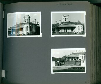
Album - Album page, Booran Road, 30, Circa 1972
... tower with low pitch pyramidal roof that provides a clear view of the racecourse. Other characteristic features include stilted segmented arches, bracketed eaves, stucco wall finish and cast cement ornamentation. A room has been added on the north-facing verandah in sympathetic style and finish. Internally the rooms are substantially intact with original marble fireplaces and intricate ceiling roses and cornices. An entrance toward the rear of the southern side of the house is said to be where the stable hands, jockeys and other staff lined up for their meals. In the southeast corner ...This photograph is part of the Caulfield Historical Album 1972. This album was created in approximately 1972 as part of a project by the Caulfield Historical Society to assist in identifying buildings worthy of preservation. The album is related to a Survey the Caulfield Historical Society developed in collaboration with the National Trust of Australia (Victoria) and Caulfield City Council to identify historic buildings within the City of Caulfield that warranted the protection of a National Trust Classification. Principal photographer thought to be Trevor Hart, member of Caulfield Historical Society. Most photographs were taken between 1966-1972 with a small number of photographs being older and from unknown sources. All photographs are black and white except where stated, with 386 photographs over 198 pages. From Glen Eira Heritage Management Plan 1996 by Andrew Ward: In 1888, John Leek, a trainer, owned Lot 15, measuring one and three quarter acres, in Booran Road, north side between Glen Eira and Neerim Roads. The land backed onto the Caulfield Racecourse Reserve. NAV was £45. In 1890 Leek built for his residence, a ten roomed brick house on the site. NAV was £200. Leek was the owner/trainer of "Ingliston" who won the Caulfield Cup in 1900. Upon the horse's death in 1901, Leek is understood to have defied tradition by spending £20 on boots for the "ragged urchins in Bourke Street" instead of "shouting" at the bar. By 1899, the property was owned and occupied by Alfred Merrill, a dentist and was known as "Andover". NA V had decreased to £ll0. By 1910, Leslie Macdonald, a gentleman had purchased the property and renamed it "Moidart". In 1910-11 Macdonald sold it to John Robertson. The property had extensive wood stables on its north-east boundary and several other outbuildings. The house continued to be described as "Brick, ten rooms" as it was in 1926 when it was owned and occupied by John Arthur, a managing director. The land measured la.2r.31p. and had a NAV of £235. Nine people lived there. In 1926, Arthur also owned the adjoining Lot 16. Other racehorses of note, known to have been stabled here include Sobar, Havelock, Proud, Future and Lord.Victorian Heritage Register https://vhd.heritagecouncil.vic.gov.au/places/13532 What is significant? Lord Lodge is a thoroughbred racehorse training complex adjacent to Caulfield Racecourse, established in 1890. The area immediately around the racecourse has been associated with horse racing activities and businesses servicing the industry since the development of the racecourse in late the 19th century. Lord Lodge was named by the present occupants after the champion racehorse Lord who was stabled there in the 1950s. In the early 20th century the property was known as 'Andover' and subsequently 'Moidart'. The site consists of a single storey brick Italianate villa, jockeys' quarters, stables and open day yards with direct access to Caulfield racecourse from the rear of the property. The villa of 10 rooms on bluestone foundations was constructed in 1890 by John Leek, a horse trainer who purchased the newly subdivided land in 1888. The house has many Victorian Italianate or Boom Style features although it is more modest than many villas of its style. It has an asymmetrical facade with a faceted bay window and a prominent central tower with low pitch pyramidal roof that provides a clear view of the racecourse. Other characteristic features include stilted segmented arches, bracketed eaves, stucco wall finish and cast cement ornamentation. A room has been added on the north-facing verandah in sympathetic style and finish. Internally the rooms are substantially intact with original marble fireplaces and intricate ceiling roses and cornices. An entrance toward the rear of the southern side of the house is said to be where the stable hands, jockeys and other staff lined up for their meals. In the southeast corner of the property, backing directly on to Caulfield racecourse, is a substantial late Victorian timber stable, probably constructed in the 1890s but first appearing on the property title in 1910. The stable has 12 stalls, a loft and brick pavement and jerkin head roof form with varnished pine-lined ceiling carried on a chamfered timber frame. It has an original roof lantern. The doors of the stalls are not the original sliding doors but swing doors obtained from a barn at Epsom Racecourse in Mordialloc prior to demolition. Outside the gambrel roof has fretted barges but the building is otherwise utilitarian. Timber throughout the stalls has been worn by chewing and rubbing of horses over the century of its use. In the southern half of the property are open day yards where the racehorses are kept during the day. The red brick, single storey jockeys' quarters to the rear of the villa were probably built around 1950. A small brick, possibly late Victorian structure on the eastern boundary thought to have originally been a gardening shed, has been converted to a stable of two stalls. Modern concrete brick stables fill the northeast portion of the property. At the front of the property two Moreton Bay Figs (Ficus macrophylla), probably planted in the late 19th century, provide shade for horses in the day yards. In the 1890s John Leek sold the property, relocating his training facility to one of the newly established racecourses at Mentone or Mordialloc (Epsom). By 1899, the property was owned and occupied by Alfred Merrill, a dentist, who named the property 'Andover'. In 1910 it was purchased by Leslie McDonald, a gentleman, and renamed 'Moidart'; sold in 1910-1911 to John Robertson; and again in 1926 to John Arthur, a racehorse owner. The Victorian Amateur Turf Club purchased the property in the late 1930s and since this time has been leased to racehorse trainers. It is unclear whether the property operated as a training facility between 1899 - 1926. Several notable trainers and jockeys are associated with Lord Lodge. The best known is Arthur 'Scobie' Breasley, Australia's most successful jockey who was apprenticed to trainer Pat Quinlan at Lord Lodge (then 'Moidart') from 1928 - 1935. Breasley rode winners of the Caulfield Cup in four successive years 1942-45 and again in 1952. John Leek, the original owner of Lord Lodge trained Ingliston, the 1900 Caulfield Cup winner. Along with 'Lord' a number of well known racehorses including Sobar, Havelock, Proud and Future were trained at Lord Lodge .....Page 40 of Photograph Album with three landscape photographs of the exterior of this house.Handwritten: 30 Booran Road [top right hand corner] / 40 [bottom right]trevor hart, jenny o'donnell, booran road, mansion, caulfield east, ingliston, sobar, havelock, proud, future, lord, andover, moidart, lord lodge, grace darling, caulfield racecourse reserve, victorian amateur turf club, historic buildings register, national estate register, caulfield cup, horses, stables, horse racing, racehorses, outbuildings, racehorse trainers, depression, 1890s, brick houses, mansions, towers, verandahs, stained glass, italianate style, victorian style, architectural features, architectural styles, john leek, leslie macdonald, john arthur, john robertson, alfred merrill, jenny odonnell