Showing 67 items matching "country victoria tourism"
-
 Federation University Historical Collection
Book, Toni Woolley et al, Port Fairy Community and Organisational Plan, 1999
... ...tourism victoria...country...University of Ballarat Students' Project. port fairy toni woolley tamara lang janelle gilbert ben balshaw grant caromody executive summary introduction background to port fairy methodology limitations appraisal of tourism planning and development to date assessment of local community issues, attitudes and involvement in tourism roles of local and regional tourism associations effectiveness of local & regional tourism associations analysis of services and service quality moyne shire council friends of port fairy tourism victoria country victoria tourism great ocean road marketing shipwreck coast tourism port fairy tourism association inc moyne shire department of natural resources and environment the western coastal board tourism accreditation board of victoria george borg craig delahoy michael hearn jodie honan judith kershaw andrea lowenthal neil martin john ploenges james purcell peter strickland mark thompson libby wilson michael pearlman battle of the moyne tourism planning great ocean road White bound book of 35 pages plus 6 appendices. ...Port Fairy Community and Organisational Plan. University of Ballarat Students' Project.White bound book of 35 pages plus 6 appendices.port fairy, toni woolley, tamara lang, janelle gilbert, ben balshaw, grant caromody, executive summary, introduction, background to port fairy, methodology, limitations, appraisal of tourism planning and development to date, assessment of local community issues, attitudes and involvement in tourism, roles of local and regional tourism associations, effectiveness of local & regional tourism associations, analysis of services and service quality, moyne shire council, friends of port fairy, tourism victoria, country victoria tourism, great ocean road marketing, shipwreck coast tourism, port fairy tourism association inc, moyne shire, department of natural resources and environment, the western coastal board, tourism accreditation board of victoria, george borg, craig delahoy, michael hearn, jodie honan, judith kershaw, andrea lowenthal, neil martin, john ploenges, james purcell, peter strickland, mark thompson, libby wilson, michael pearlman, battle of the moyne, tourism planning, great ocean road -
 Ballarat Tramway Museum
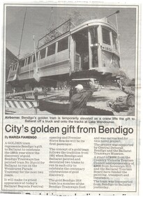
Newspaper, The Courier Ballarat, "City's golden gift from Bendigo", 2/03/2001 12:00:00 AM
... Mentions the 1951 painting of trams to celebrate the 100th anniversary, sponsorship from the Country Victoria Tourism Council, Sovereign Hill and the Ballarat Tourism Board. ...Mentions the 1951 painting of trams to celebrate the 100th anniversary, sponsorship from the Country Victoria Tourism Council, Sovereign Hill and the Ballarat Tourism Board. ...Newspaper Clipping from The Courier, Ballarat 2/3/2001, titled "City's golden gift from Bendigo", page 5. Item written by Mariza Fiamengo about the delivery of the Gold Tram (Ballarat 45) from Bendigo, the previous day. Mentions the 1951 painting of trams to celebrate the 100th anniversary, sponsorship from the Country Victoria Tourism Council, Sovereign Hill and the Ballarat Tourism Board. Photo shows the tram about to be positioned on its trucks.gold tram, bendigo, btm, gold -
 Kiewa Valley Historical Society
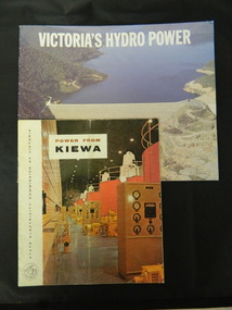
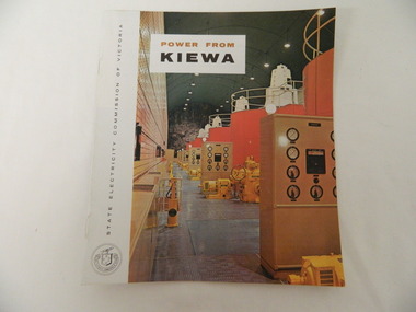
Booklets - Kiewa Hydro Electric Scheme, 1. "Power From Kiewa" and 2. "Victoria's Hydro Power", 1. Made in July 1968 and 2. Made in Aug. 1985
... country 1. The State Electricity Commission of Victoria built the Kiewa Hydro Electric Scheme from the 1930's to the 1960's. This booklet was to inform visitors and to promote tourism. 2. ...1. The State Electricity Commission of Victoria built the Kiewa Hydro Electric Scheme from the 1930's to the 1960's. This booklet was to inform visitors and to promote tourism. 2. The State Electricity Commission built several hydro power stations from 1928 - 1981. This booklet names each with a summary and explanation.The State Electricity Commission of Victoria built the Kiewa Hydro Electric Scheme establishing infrastructure such as the Bogong and Mt Beauty townships and the opportunity for tourism in the area.1. Colored soft cover with photo of McKay Creek Power Station on the front and Mt Beauty township on the back. Published by the SECV 2. Colored soft cover with Rocky Valley Dam on the front and inserted photo of a stream and snow on the back. Published by the SEC.state electricity commission of victoria; kiewa hydro electric scheme; victoria's hydro electric power; kiewa; mckay creek power station; clover power station; west kiewa power station -
 Kiewa Valley Historical Society
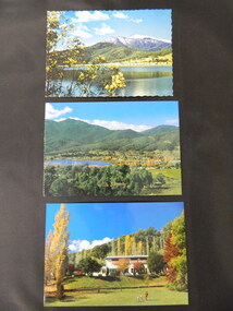
Postcards - Mt Beauty x3
... country Mt Beauty is an all year tourist destination. Mt Beauty Chalet no longer exists as it was burnt down. It was a landmark in the town especially during the State Electricity Commission of Victoria construction days. Mt Beauty is a construction town built in the 1940's and 1950's by the State Electricity Commission of Victoria during the construction of the Kiewa Hydro Electric Scheme. Mt Beauty Chalet; Mt Beauty Township; Postcards Three colored postcards created for tourism ...Mt Beauty is an all year tourist destination. Mt Beauty Chalet no longer exists as it was burnt down. It was a landmark in the town especially during the State Electricity Commission of Victoria construction days.Mt Beauty is a construction town built in the 1940's and 1950's by the State Electricity Commission of Victoria during the construction of the Kiewa Hydro Electric Scheme.Three colored postcards created for tourism 1. Mt Beauty Chalet 2. Mt Beauty Township 3. Mt Beauty Township with Pondage and Mt Bogongmt beauty chalet; mt beauty township; postcards -
 Kiewa Valley Historical Society
Folder - Bogong High Plains and Falls Creek, 1960's and 1970's
... Kiewa Valley Historical Society Mount Beauty Information Centre 31 Bogong High Plains Rd Mt Beauty high-country Tourism on the Bogong High Plains developed after/during the State Electricity Commission of Victoria construction of the Kiewa Hydro Electric Scheme. ...Tourism on the Bogong High Plains developed after/during the State Electricity Commission of Victoria construction of the Kiewa Hydro Electric Scheme.With the completion of the power stations on the Bogong High plains, tourism has created a new focus and different infrastructure/lifestyle for the community.A blue folder with a collection of papers & booklets on: 1. Discovery of Bogong High Plains 1962 2. SECV Discovery of Bogong High Plains 1968 3. SECV Kiewa Hydro Electric Scheme 1911 - 1961 4. Newspaper cutting - Mt Beauty 1974 5. McKay Creek Power Station and Clover Power Station 6. Falls Creek and Mt Beauty Tourist Map & brochures 7. Bogong High Plains Tour 1973bogong high plains; falls creek; tourism; -
 Kiewa Valley Historical Society
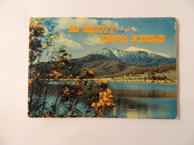
Postcard (fold out) - Mt Beauty and the Kiewa Scheme, Victoria, Mt Beauty and the Kiewa Scheme, c1960s
... country S. K Pearce owned shops in Mt Beauty and Tawonga. The postcard was used for tourism to attract visitors to the Mt Beauty township and the Kiewa Scheme on the Bogong High Plains. The postcard gives a brief history of the town and area both created by the State Electricity Commission of Victoria. ...S. K Pearce owned shops in Mt Beauty and Tawonga. The postcard was used for tourism to attract visitors to the Mt Beauty township and the Kiewa Scheme on the Bogong High Plains. The postcard gives a brief history of the town and area both created by the State Electricity Commission of Victoria.The photos are historically significant and include prominent places in the Kiewa Valley, Mt Beauty and the Bogong High Plains. S. K Pearce was a prominent shop owner in the area having shops in Tawonga and in Mt Beauty as seen in one of the photos. The postcards are of interest as they are an example of advertising for tourism in the 1960's.Fold out postcards including a panel on information on Mt Beauty and the Kiewa Scheme, 12 colored labelled photos, an address & letter written in black biro. Multiple copies.Letter from Roma to 'Dad and Chris'. Their address in Bayswater. Postage stamp from Mount Beautymt beauty, kiewa hydro electric scheme, s. k. pearce, tourism -
 Kiewa Valley Historical Society
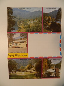
Postcard - Bogong Village x2
... country Bogong Village became a tourist town after the State Electricity Commission of Victoria sold it upon the completion of the Kiewa Hydro Electric Scheme. Bogong Village was built by the SEC as a town for its employees on the Kiewa Hydro Electric Scheme. This card represents the village in later years when it was being promoted as a holiday resort. bogong village tourism ...Bogong Village became a tourist town after the State Electricity Commission of Victoria sold it upon the completion of the Kiewa Hydro Electric Scheme.Bogong Village was built by the SEC as a town for its employees on the Kiewa Hydro Electric Scheme. This card represents the village in later years when it was being promoted as a holiday resort.Cover: 5 colored photos of Bogong Village with a blank space for writing the address and affixing the postage stamp. Other side is covered with horizontal parallel lines on which to write. Paper is made to fold into three with gum at the top to seal.bogong village, tourism -
 Kiewa Valley Historical Society
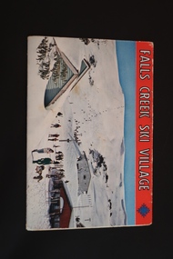
Souvenir Postcard Folder – Falls Creek Ski Village
... country Falls Creek Ski Resort developed during the construction of the Kiewa Hydro Electric Scheme built by the State Electricity Commission of Victoria. The first ski lodge was built in 1948 by workers from the scheme. The first lift, a rope tow, was built in 1951 and the first chairlift in Australia was constructed there in 1957. Falls Creek Post Office opened in 1958. Tourism ...Falls Creek Ski Resort developed during the construction of the Kiewa Hydro Electric Scheme built by the State Electricity Commission of Victoria. The first ski lodge was built in 1948 by workers from the scheme. The first lift, a rope tow, was built in 1951 and the first chairlift in Australia was constructed there in 1957. Falls Creek Post Office opened in 1958. Tourism was growing and being encouraged by local businesses.The souvenir postcard was produced by Mr S. K. Pearce a Mt Beauty businessman. It was a memento for skiers and visitors to the Falls Creek and Mt Beauty area to send to family and friends as a reminder of their visit to the region or to keep as a personal souvenir. It presented an excellent promotional opportunity for enterprising local businessmen to promote the area to skiers and tourists near and far. It also presents an excellent pictorial history of the Falls Creek area around the late 1950's and 1960's.Colour postcard folder (unused) containing 12 labelled colored photos of the Falls Creek ski area and surrounds with a blank 'page' entitled 'Correspondence' and another for the address.falls creek, skiing, snow sports, s. k. pearce, tourism, secv -
 Kiewa Valley Historical Society
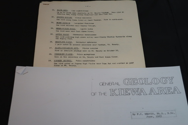
Information on Geology, Flora, Birds of the Kiewa Area, C1960
... country Information of the Kiewa area commissioned by the State Electricity Commission of Victoria for use by the general public. To inform the interested public, visiting the Kiewa area, about the Geology, Flora and birds as documented by various professionals and commissioned by the State Electricity Commission of Victoria. Flora; Geology; Birds; Kiewa Area; SECV; tourism ...Information of the Kiewa area commissioned by the State Electricity Commission of Victoria for use by the general public.To inform the interested public, visiting the Kiewa area, about the Geology, Flora and birds as documented by various professionals and commissioned by the State Electricity Commission of Victoria.1. Foolscap x 4 sheets, numbers 11-80 list of birds and description 2. A4 size x 4 sheets "Birds of the Bushland" 3. A4 size x 4 sheets "The Three Floras of Bogong" 4. A4 Size x 4 sheets "General Geology of the Kiewa Area" 1. -2- centre top of first page. List of birds 11-27. …/3 bottom Rt. hand corner of top page 2. Photocopied sheets, printed on Rt. side of paper only. Heading is "BIRDS of the BUSHLAND" followed by diagrams and name of 13 birds. Photocopied using right half of paper only. 3. 'THE THREE FLORAS OF BOGONG' inside a rectangular box. Midway down page 'Published by the State Electricity Commission of Victoria" and towards bottom of page 'October, 1964'. Both inscriptions inside a rectangular box. Photocopied using right half of paper only. 4. photocopied sheets on right side of paper only, GENERAL GEOLOGY OF THE KIEWA AREA by F>C> Beavis, Ph.D., B.SC. June, 1963. 4.flora; geology; birds; kiewa area; secv; tourism; environment -
 Kiewa Valley Historical Society
Papers - Falls Creek Tourist Area Management Committee, August 1984
... Kiewa Valley Historical Society Mount Beauty Information Centre 31 Bogong High Plains Rd Mt Beauty high-country Falls Creek is a ski resort in the north east of Victoria on the Bogong High Plains. Members of business's (accommodation & restaurants) formed the Falls Creek Chamber of Commerce to promote tourism 'under' the Falls Creek Tourist Area Management Committee. ...Falls Creek is a ski resort in the north east of Victoria on the Bogong High Plains. Members of business's (accommodation & restaurants) formed the Falls Creek Chamber of Commerce to promote tourism 'under' the Falls Creek Tourist Area Management Committee. The Falls Creek Tourist Area Management Committee under the direction of the State Electric Commission of Victoria came into effect in 1959 and from then on building sites were leased and building and sewerage controls were applied. In 1979 the Victorian State Government had established the Ski Industry of Victoria working party with a brief report on its operation. These papers give an insight into the business of the Falls Creek Chamber of Commerce in 1984 eg. car parking, noise, closure of the resort due to heavy snow falls, the media and general development of the resort. Local business people are named as attending the meeting indicating many non English surnames. 4 yellowed papers typed on both sides of the first 3 pages. irst paper has 6 items listed re Falls Creek Chamber of Commerce / Sub Committee on General Booking Conditions.Dated 15th August 1984 Next 3 papers dated 13th August 1984 Falls Creek Chamber of Commerce / Minutes of General Meetingfalls creek, ski resort, bogong high plains, falls creek chamber of commerce, snow, ski lodges, -
 Kiewa Valley Historical Society
Booklet - Victoria's Hydro Power x2, Victoria's Hydro Power - SEC, August 1975
... country The State Electricity Commission of Victoria built several hydro power stations from 1928-1981. This book names each - up to 1975 - with a summary and explanation. The State Electricity Commission of Victoria built the Kiewa Hydro Electric Scheme which included the construction of Bogong Power Station, McKay Creek Power Station and West Kiewa Power Station. It also established infrastructure such as the townships of Bogong and Mt Beauty and the opportunity for tourism ...The State Electricity Commission of Victoria built several hydro power stations from 1928-1981. This book names each - up to 1975 - with a summary and explanation.The State Electricity Commission of Victoria built the Kiewa Hydro Electric Scheme which included the construction of Bogong Power Station, McKay Creek Power Station and West Kiewa Power Station. It also established infrastructure such as the townships of Bogong and Mt Beauty and the opportunity for tourism in the area Colored green/blue 'splash' of water on front cover with SEC logo in white centred under the yellow printed title. On the back cover is the SEC logo at the bottom in the middle.state electricity commission of victoria; kiewa hydro electric scheme; mckay creek power station; clover power station; west kiewa power station -
 Kiewa Valley Historical Society
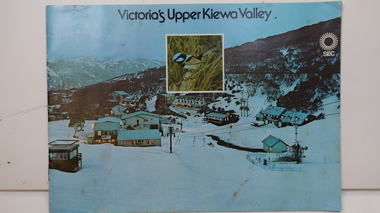
Booklet - SEC x2, 1. Victoria's Kiewa Valley 2. Victoria's Upper Kiewa Valley, No. 2 is dated October 1978
... Kiewa Valley Historical Society Mount Beauty Information Centre 31 Bogong High Plains Rd Mt Beauty high-country The State Electricity Commission of Victoria built the Kiewa Hydro Electric Scheme and was keen to promote tourism in the area. ...The State Electricity Commission of Victoria built the Kiewa Hydro Electric Scheme and was keen to promote tourism in the area. The booklet includes Facilities, Falls Creek Ski Resort, the Kiewa Works Area, the Three Floras of Bogong, the Geology of the Kiewa area, the Bird and Animal life of Bogong and the Kiewa Hydro Electric Scheme. The colored photos and the map on the back appeal to the reader/tourist.The SECV promoted tourism in the Kiewa Valley especially the area of the Kiewa Hydro Electric Scheme. This booklet is attractive and informative with a lot of detail. This proved to be the early stages of tourism in the area in what is now a very popular tourist destination and the main industry for the Upper Kiewa Valley.Blue cover with photo of Falls Creek at night. Title in black print at the centre top under which is an insert photo of a blue wren and SEC logo in white towards the top far right. Back cover is light green with a tourist map of the area. The text is complimented with brightly colored photos throughout.state electricity commission of victoria; kiewa hydro electric scheme; tourism; bogong; flora; fauna; geology; -
 Kiewa Valley Historical Society
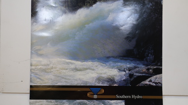
Booklet - Southern Hydro, Southern Hydro
... Kiewa Valley Historical Society Mount Beauty Information Centre 31 Bogong High Plains Rd Mt Beauty high-country Southern Hydro Ltd. was established in the late 1990s as a result of the disaggregation of the former State Electricity Commission of Victoria. It operates 10 power stations mainly in the north-east of Victoria Southern Hydro continued to encourage tourism as did the former State Electricity Commission of Victoria. ...Southern Hydro Ltd. was established in the late 1990s as a result of the disaggregation of the former State Electricity Commission of Victoria. It operates 10 power stations mainly in the north-east of VictoriaSouthern Hydro continued to encourage tourism as did the former State Electricity Commission of Victoria. This brochure is very similar to one previously published by the SECV "Victoria's Hydro Power" except only including those that it operates. Within the KHES the power stations were McKay Creek, Clover and West Kiewa. The change of ownership of hydro power from a government body to private enterprise in the late 1990s is of significant interest to the historian and consumer.Colored photo water spraying onto rocks with black strip across the bottom and logo (4 gold lines forming an "S", a blue triangle with grey cylinder beneath) of Southern Hydro within the strip. Back cover has a similar photo with 4 small photos of men inserted in the black column. This 23 page book gives a history of Southern Hydro and its 10 hydro-electric power stations that it operates. The book lists these and gives a description of each.Top right hand corner of page 5 has a piece of tape stuck over the print with "Page 11 to photo copy & enlarge" secv; khes; mckay creek power station; clover power station; west kiewa power station; mount beauty; rocky valley dam; -
 Kiewa Valley Historical Society
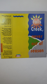
Brochure - Falls Creek Tourism, Falls Creek Never Out of Season
... Kiewa Valley Historical Society Mount Beauty Information Centre 31 Bogong High Plains Rd Mt Beauty high-country Falls Creek is a Ski Resort in the north east of Victoria. This brochure has been produced to encourage tourists to visit throughout the year. Tourism ...Falls Creek is a Ski Resort in the north east of Victoria. This brochure has been produced to encourage tourists to visit throughout the year.Tourism to the Kiewa Valley is an important industry for the area. Falls Creek is a ski resort with accommodation during winter for skiers, snow boarders and other snow sports. It involves entertainment, restaurants and associated workers. This brochure is produced to promote the resort throughout the year to increase the occupancy of these lodges. The tourist industry has increased steadily with fishing, cycling and bush walking increasing numbers in the area.Glossy square brochure folded in in half and half again. Front page is yellow on the left with black print on the far left. The right side has the title with blue, green and grey background with yellow, orange and white as part of the title. The back is a man standing in front of a sunset with print in a column towards the right side. Inside includes a map with advertisements for accommodation surrounding it.falls creek ski resort; alpine region in victoria; mountain lodges; -
 Kiewa Valley Historical Society
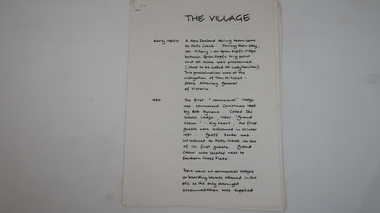
Papers - Falls Creek History, The Village
... Kiewa Valley Historical Society Mount Beauty Information Centre 31 Bogong High Plains Rd Mt Beauty high-country Timeline of Falls Creek during the 1950s Falls Creek is a snow resort on the Bogong High Plains, Victoria. The 1950s saw the village develop from its beginning to a popular ski resort. falls creek skiing tourism snow resort 10 pages stapled top left corner. ...Timeline of Falls Creek during the 1950sFalls Creek is a snow resort on the Bogong High Plains, Victoria. The 1950s saw the village develop from its beginning to a popular ski resort.10 pages stapled top left corner. Includes a timeline of Falls Creek from early 1950s to the late 1950s. Titled 'The Village' and handwritten on one side only.falls creek, skiing, tourism, snow resort -
 Kiewa Valley Historical Society
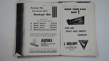
Papers - Skiing at Falls Creek
... country Skiing at Falls Creek from the 1940s has changed re - equipment, including eg. types of tows, gear and clothes. These pages give an insight into the 1960 and 1961 developments re accommodation, social scene, ads re equipment etc. and articles eg.on Tow-bar lifts, people, workers and tourists. Falls Creek, one of Victoria's most popular ski resorts, was developing quickly in the early 1960s. falls creek skiing tourism ...Skiing at Falls Creek from the 1940s has changed re - equipment, including eg. types of tows, gear and clothes. These pages give an insight into the 1960 and 1961 developments re accommodation, social scene, ads re equipment etc. and articles eg.on Tow-bar lifts, people, workers and tourists.Falls Creek, one of Victoria's most popular ski resorts, was developing quickly in the early 1960s. Photocopies of pages from 'Schuss' ski magazine 1960 and 1961 selected for the references to Falls Creek.falls creek, skiing, tourism -
 Kiewa Valley Historical Society
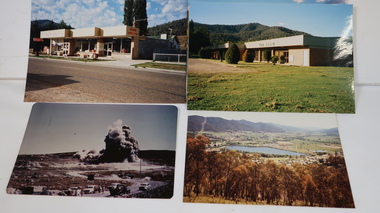
Photo Collection - Wally Howell, Falls Creek and Kiewa Hydro Electric Scheme including Mt Beauty
... country 1. Falls Creek ski resort is on the Bogong High Plains 2. Kiewa Hydro Electric Scheme (late 1940s to early 1960s) was constructed by the State Electricity Commission of Victoria and included the townships of Bogong and Mt Beauty. The photos were taken by Wally Howell. Falls Creek is at the head of the Kiewa Valley and a major tourist attraction. Kiewa Hydro Electric Scheme was constructed by the SECV and included the creation of the Mt Beauty township. falls creek snow resort skiing ski lodges sundance inn malony's ski hire spargos lodge t-bar lifts mt beauty tourism ...1. Falls Creek ski resort is on the Bogong High Plains 2. Kiewa Hydro Electric Scheme (late 1940s to early 1960s) was constructed by the State Electricity Commission of Victoria and included the townships of Bogong and Mt Beauty. The photos were taken by Wally Howell.Falls Creek is at the head of the Kiewa Valley and a major tourist attraction. Kiewa Hydro Electric Scheme was constructed by the SECV and included the creation of the Mt Beauty township.1. 16 Coloured photos of Falls Creek - not dated or labelled. Includes Malony's Ski Hire & Restaurant and Sundance Inn 2. 162 Coloured Photos not dated or labelled. Includes Kiewa Hydro Electric Scheme and Mt Beauty. Some multiple copies. 1. "Processed by Kodak Oct. 85 M" on printed in red ink on the back of one photo. Also, later labels were added in ink to identify each photo.falls creek, snow resort, skiing, ski lodges, sundance inn, malony's ski hire, spargos lodge, t-bar lifts, mt beauty, tourism -
 Kiewa Valley Historical Society
Booklet - S.E.C.V. x2, Power from Kiewa
... country The State Electricity Commission of Victoria constructed the Kiewa Hydro Electric Scheme. Their public relations employees published booklets to promote the Scheme and the area. In this booklet there are photos of some of the major work constructions with an explanation of how they work and their purpose, a map of the Scheme and an article and photos of tourist facilities and activities that are available. This booklet promotes the Kiewa Hydro Electric Scheme and tourism ...The State Electricity Commission of Victoria constructed the Kiewa Hydro Electric Scheme. Their public relations employees published booklets to promote the Scheme and the area. In this booklet there are photos of some of the major work constructions with an explanation of how they work and their purpose, a map of the Scheme and an article and photos of tourist facilities and activities that are available.This booklet promotes the Kiewa Hydro Electric Scheme and tourism indicating that tourism was recognised as a new industry for the area. The photos give a pictorial history of the area eg. skiing using the Summit T-bar lift and includes the facilities available at the time. The explanation of the Kiewa Hydro Electric Scheme is a basic resource for students interested in Hydro power.Slim booklet with photo of McKay Creek Power Station on the front cover and the title in brown and black at the top. Printed along the spine is State Electricity Commission of Victoria.state electricity commission of victoria. kiewa hydro electric scheme. tourism. t-bar ski tow. falls creek -
 Kiewa Valley Historical Society
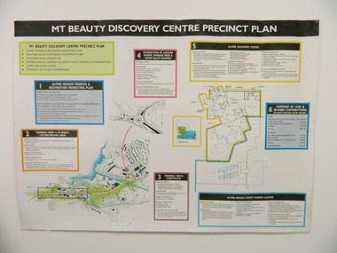
Poster - Mt Beauty Discovery Centre Precinct Plan
... Kiewa Valley Historical Society Mount Beauty Information Centre 31 Bogong High Plains Rd Mt Beauty high-country The current (2015) Mt Beauty Tourist Centre site was to be upgraded into a 'Sports Tourism Cluster' with funding from the Government and the Alpine Shire with 'In Kind' assistance from Falls Creek Resort management Board, Parks Victoria and the Local Community & Tourism Industry. ...The current (2015) Mt Beauty Tourist Centre site was to be upgraded into a 'Sports Tourism Cluster' with funding from the Government and the Alpine Shire with 'In Kind' assistance from Falls Creek Resort management Board, Parks Victoria and the Local Community & Tourism Industry. This project didn't go ahead.The Mt Beauty town was handed over to the Alpine Shire in the 1960's after completion of the Kiewa Hydro Electric Scheme. Plans for up dating facilities are on-going but are rarely completed. This poster is an example of this.Very large laminated poster depicting 6 points for the Alpine Region Sports Tourism Cluster. Each point has a coloured border and background to black writing. There are 3 maps.mt beauty. tourism. discovery centre. sports cluster. -
 Kiewa Valley Historical Society
Maps - Tourist
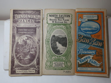
... country These maps were all dated 1933 which was before the construction of the Kiewa Hydro Electric Scheme and when Tawonga was spelt Towonga. North East Victoria in 1933 was before the construction of the Kiewa Hydro Electric Scheme so the townships of Mt Beauty and Bogong are not shown. The description of the Snow Lines was important as skiers, bushwalkers and campers relied on them. The details on the map include "ADB. Numbered from A.1-377 round plates. CD Numbered from C 1-235 square plates. Poles about 3 chains apart 27 to the mile." 1933 Maps Tourism ...These maps were all dated 1933 which was before the construction of the Kiewa Hydro Electric Scheme and when Tawonga was spelt Towonga. North East Victoria in 1933 was before the construction of the Kiewa Hydro Electric Scheme so the townships of Mt Beauty and Bogong are not shown. The description of the Snow Lines was important as skiers, bushwalkers and campers relied on them. The details on the map include "ADB. Numbered from A.1-377 round plates. CD Numbered from C 1-235 square plates. Poles about 3 chains apart 27 to the mile." 3 Tourist location maps (folded) and printed on parchment. 1. Tourist map of the Dandenong Ranges. Brown cover. dated 6-4-33. Govt. printer showing roads, tracks in red and heights of the land. 2. Tourist Map of Warburton, Mt Baw Baw, and Walhalla. Blue and Orange cover. dated 23-5-33 Govt. printer. 3 different maps of each area showin roads, tracks and timber tramways.Also in red and blue. 3. Tourist Map of North Eastern Victoria including Bogong High Plains Mt Buffalo Etc. Green cover. dated June 1933 Govt. printer. Main map and insert titled Bogong High Plains. Showing roads , tracks and tram ways. On insert showing snow poles. Also Red and Blue and mountains.By Authority of H.J. Green - 6 pence. Dept of Lands and Survey, Melbourne1933 maps, tourism maps, bogong high plains map 1933, snow poles -
 Kiewa Valley Historical Society
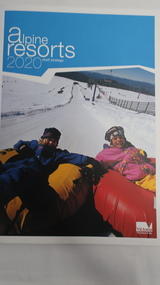
Book - Alpine Resorts - 2020 draft strategy, Alpine Resorts 2020 draft strategy
... country This is a commissioned report auspiced by the State Government of Victoria - Department of Sustainability and Environment 2003. This report was prepared to guide the sustainable long-term planning and management of Victoria's six Alpine Resorts. Falls Creek, Lake Mountain, Mount Baw Baw, Mount Buller, Mount Hotham and Mount Stirling, after the catastrophic bush fires of 2002- 2003. Tourism ...This is a commissioned report auspiced by the State Government of Victoria - Department of Sustainability and Environment 2003.This report was prepared to guide the sustainable long-term planning and management of Victoria's six Alpine Resorts. Falls Creek, Lake Mountain, Mount Baw Baw, Mount Buller, Mount Hotham and Mount Stirling, after the catastrophic bush fires of 2002- 2003.Colorured cardboard front cover with two people on air mattresses in foreground. Title white on bue top left corner. 40 glossy thick paper/card pages. A4Logo "Victoria / The Place to betourism in alpine resorts, sustainability and environment, victorian government, 2002-2003 bushfires -
 Kiewa Valley Historical Society
Hankerchief
... country Mount Beauty is a tourist destination and this 'hanky' may have been a souvenir. Since the completion of the Kiewa Hydro Electric Scheme Mount Beauty has become a tourist destination. The 'hanky' depicts the snow on the mountains and nature as an advertisement for visiting the town and its surrounds. Mount Beauty Tourism Handkerchief White cotton handkerchief with lace edges and a blue print in one corner. The blue print is a picture of mountains with snow and with wattle trees in the foreground and with the words Mount Beauty Victoria ...Mount Beauty is a tourist destination and this 'hanky' may have been a souvenir.Since the completion of the Kiewa Hydro Electric Scheme Mount Beauty has become a tourist destination. The 'hanky' depicts the snow on the mountains and nature as an advertisement for visiting the town and its surrounds.White cotton handkerchief with lace edges and a blue print in one corner. The blue print is a picture of mountains with snow and with wattle trees in the foreground and with the words Mount Beauty Victoria.mount beauty tourism, handkerchief -
 Kiewa Valley Historical Society
Folder - Falls Creek
... country Falls Creek Snow Resort is on the Bogong High Plains in north east Victoria. It competes with other Australian snow resorts during Winter. This folder was created in the 1990s. Falls Creek began during the construction of the Kiewa Hydro Electric Scheme. It is a major ski resort in Australia and is currently promoting tourism ...Falls Creek Snow Resort is on the Bogong High Plains in north east Victoria. It competes with other Australian snow resorts during Winter. This folder was created in the 1990s.Falls Creek began during the construction of the Kiewa Hydro Electric Scheme. It is a major ski resort in Australia and is currently promoting tourism in Summer especially for bush walkers and cyclists.Red plastic folder with 6 pages in plastic sleeves. Each page has headings describing and promoting the facilities and benefits of Falls Creek Snow Resort.falls creek snow resort, tourism in alpine resorts -
 Kiewa Valley Historical Society
Souvenirs - Mt Beauty
... country Originally an SEC town built for workers on the Kiewa Hydro Electric Scheme. It became a tourist centre from the 1960s. Examples made to increase tourism with historical photos, historical items no longer used or sought after. Items such as these are a different way of advertising to on-line methods used today Mt Beauty tourism 1. Printed bottom left hand corner "Mount Beauty, Victoria ...Originally an SEC town built for workers on the Kiewa Hydro Electric Scheme. It became a tourist centre from the 1960s.Examples made to increase tourism with historical photos, historical items no longer used or sought after. Items such as these are a different way of advertising to on-line methods used today1. Coloured shiny poster with photos of mountains, river and fishing backed on to orange & white pattern. 2. Christmas card "Mt Bogong and Mr Beauty Township" on the back in gold Markdon Prints, Porpunkah ..."" 3. Plastic coloured trays x3 - Mt Beauty Vic. x2 and Mt Beauty Victoria (4 photos including Mt Bogong, Falls Creek x2, Kiewa Valley.) 4.Silver plated spoon "Mt Beauty Vic." 1. Printed bottom left hand corner "Mount Beauty, Victoria" 2.Centre front "The Seasons Greetings" with title written under painting also "From the painting by Marcus L. O'Donnell" 3. On the back of the tray with 4 photos - embossed "A Starlite Product ..." 4. Embossed on back of handle "Stuart / Silver plated"mt beauty tourism -
 Kiewa Valley Historical Society
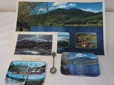
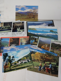
Photos, Postcards - Kiewa Valley
... tourism has also changed as attractions are now available on-line. Postcards Kiewa Valley 1. 9 Coloured Photos of Bogong (5) and Visitors Information Centre display (4) 2. Two fold out coloured sets of postcards "Mt Beauty and the Kiewa Scheme", "Mt. Beauty Victoria" 3. x10 Coloured postcards Mt Beauty, Kiewa Valley, Bogong 4. x6 Coloured postcards High Country ...Mt Beauty township, at the head of the Kiewa Valley, is situated at the foot of Mt Bogong. The town was established by the State Electricity Commission of Victoria during the construction of the Kiewa Hydro Electric Scheme on the High Plains.Mt Beauty is a popular tourist resort. The main highway from Mt Beauty to the Bogong High Plains is most picturesque throughout the year. During the winter months, Falls Creek provides access to Falls Creek Ski Village for snow sports. Tawonga, 6.5 km north of Mt Beauty, is famed for its trout fishing and camping on the Kiewa River. Deciduous trees make a show of colour during Autumn. The postcards are of historical value showing photos taken at an earlier time.The postcards can be compared to the attractions of the time as they do not include cycling (mountain bikes and road bikes), snow boarding, gliding and paragliding. Advertising for tourism has also changed as attractions are now available on-line. 1. 9 Coloured Photos of Bogong (5) and Visitors Information Centre display (4) 2. Two fold out coloured sets of postcards "Mt Beauty and the Kiewa Scheme", "Mt. Beauty Victoria" 3. x10 Coloured postcards Mt Beauty, Kiewa Valley, Bogong 4. x6 Coloured postcards High Country and Bogong Villagepostcards kiewa valley -
 Kiewa Valley Historical Society
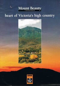
Poster Brochure, Mt Beauty Tawonga Heart Of Victoria's High Country, Circa 1995
... Also see "KVHS 0125" tourism mt beauty tawonga photographs victorian alps inside panoramic photo of snow tipped alpine mountain range incorporating the Mount Beauty township, farming area of the Kiewa Valley and relevant tourist orientated information Brochure folds out from a 20.5cm x 29.5cm to 82cm x 29.5cm poster type document Mt Beauty Tawonga Heart Of Victoria's High Country Poster Brochure produced by Cook Green & Moore, Albury Photos by A. ...The Item is a pictorial time piece of the valley and usage, farms,industry,town area, vegetation and winter snow levels Historical and the social-economical development at circa 1995 of land usage and residential buildings style.Major social events e.g. Festival of the Bogong Moth and the Mt Beauty Mardi Gras. It is also a good historical record of tourism campaigns of the Alpine Shire and Mt Beauty Chamber of Commerce. Also see "KVHS 0125"Brochure folds out from a 20.5cm x 29.5cm to 82cm x 29.5cm poster type documentinside panoramic photo of snow tipped alpine mountain range incorporating the Mount Beauty township, farming area of the Kiewa Valley and relevant tourist orientated informationtourism mt beauty tawonga photographs, victorian alps -
 Kiewa Valley Historical Society
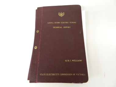
Book- History of SEC at Kiewa x2, Technical History of the Kiewa Hydro Scheme, circa 1960's
... country. This project was at a time when financial and security pressures where at a high and fluctuating level. This project was the major contributor to the expansion and diversity of non rural activities within the region. It was directly and indirectly the cause of better transportation avenues, tourism and the lifting of the regions natural facilities to sustain an ever increasing long term and short term population. kiewa hydro electricity scheme victorian state electricity commission history proposals kiewa scheme's plans book h.h.c. williams Title "KIEWA HYDRO ELECTRICITY SCHEME TECHNICAL HISTORY" author and compiler "H.H.C.WILLIAMS" below this "STATE ELECTRICITY COMMISSION OF VICTORIA" This large hard (thick cover) book has both front and back sides fastened to the spine by two brass screw on pins. ...This book of planning and construction details covers the first detailed records the Kiewa Hydro Electricity Scheme of 1919 (ORIGINAL), 1958 (2nd Modified Plan) to the last general plan of 1961. It is an excellent overview of one of Australia's greatest construction projects (along with the Snowy River Hydro Scheme). This book highlights in detail the planning, programming and construction phases throughout the life of the construction from 1919 onwards until the 1960's. There were a few copies made using carbon paper and a type writer on foolscap paper.This book with its Parts A to D, photographs and plans/tables is very significant to the Kiewa Valley region as it details "the bones" of one of Australia's greatest construction projects that was undertaken by Governments that had the foresight and the will to undertake such a costly and environmentally imposing project for the benefit of their states and their country. This project was at a time when financial and security pressures where at a high and fluctuating level. This project was the major contributor to the expansion and diversity of non rural activities within the region. It was directly and indirectly the cause of better transportation avenues, tourism and the lifting of the regions natural facilities to sustain an ever increasing long term and short term population.This large hard (thick cover) book has both front and back sides fastened to the spine by two brass screw on pins. The book title, author/compiler and the commissioning organisation (STATE ELECTRICITY COMMISSION OF VICTORIA) together with the SEC Vic emblem are all embossed in gold script.The spine is also embossed with the title. The book contains 396 pages consisting of the 390 pages which are the duplicate(carbon copy) of the original type written pages and 6 pages of site plans. Sprinkled throughout the book are 36 original photographs of various stages of construction. There are also 17 sketches/plans scattered throughout and 22 tables.Title "KIEWA HYDRO ELECTRICITY SCHEME TECHNICAL HISTORY" author and compiler "H.H.C.WILLIAMS" below this "STATE ELECTRICITY COMMISSION OF VICTORIA"kiewa hydro electricity scheme, victorian state electricity commission, history, proposals, kiewa scheme's plans, book, h.h.c. williams -
Marysville & District Historical Society
THE TRIANGLE NEWS-VOL 24 NO 6-14 FEBRUARY 1997
... victoria...australia...humans vs country...taggerty herb farm...code one concert...the keppel name landmarks...community news...reflections on history...marysville & district historical society...community health services...mystic mountain tourism...Marysville & District Historical Society 39 Darwin Street Marysville yarra-valley-and-the-dandenong-ranges marysville victoria australia humans vs country taggerty herb farm code one concert the keppel name landmarks community news reflections on history marysville & district historical society community health services mystic mountain tourism cocktail party mops church news marsysville bowls club golf club news mid goulburn water marysville cricket club for sale commissioner's column public notices marysville village gilberts restaurant fruit salad farm st john ambulance emergency first aid level 2 phelps bakery marysville tattslotto lions club buxton primary school trades directory triangle real estate THE TRIANGLE NEWS-VOL 24 NO 6-14 FEBRUARY 1997 ...marysville, victoria, australia, humans vs country, taggerty herb farm, code one concert, the keppel name landmarks, community news, reflections on history, marysville & district historical society, community health services, mystic mountain tourism cocktail party, mops, church news, marsysville bowls club, golf club news, mid goulburn water, marysville cricket club, for sale, commissioner's column, public notices, marysville village, gilberts restaurant, fruit salad farm, st john ambulance, emergency first aid level 2, phelps bakery, marysville tattslotto, lions club, buxton primary school, trades directory, triangle real estate -
Marysville & District Historical Society
THE TRIANGLE NEWS-VOL 27 NO 43-3 NOVEMBER 2000
... victoria...australia...our link with history...keppel family...marysville & district historical society...the australia hotel...australia day 2001...lions club...diary dates...mystic mountains tourism...marysville & district ratepayers' & residents' assocn...advertising rates...advertising deadline...narbethong fire brigade...marysville & district horse riders...novelty & games day...fire calls...murrindindi shire council...time out travel healesville...advertisements...church notices...mops...old yarra track tea rooms...2001 kinder enrolments...street stall...community carols...minefield campaign...igloo roadhouse...fm 88 smooth jazz...marysville art exhibition...golf report...cricket club...duck race...marysville country...Marysville & District Historical Society 39 Darwin Street Marysville yarra-valley-and-the-dandenong-ranges marysville victoria australia our link with history keppel family marysville & district historical society the australia hotel australia day 2001 lions club diary dates mystic mountains tourism marysville & district ratepayers' & residents' assocn advertising rates advertising deadline narbethong fire brigade marysville & district horse riders novelty & games day fire calls murrindindi shire council time out travel healesville advertisements church notices mops old yarra track tea rooms 2001 kinder enrolments street stall community carols minefield campaign igloo roadhouse fm 88 smooth jazz marysville art exhibition golf report cricket club duck race marysville country club bowls section gardening corner flower plot farm nursery mystic mountains open gardens festival murrindindi community health services remembrance day fire brigade news murrindindi valley economic project councillor lyn gunter comments vic roads bike ride grants to boost lake eildon summer fire safety strategy country touch marysville s.e.s. news n.y.e. gallipoli park public notices for sale rural & lifestyle property marketing triangle property news THE TRIANGLE NEWS-VOL 27 NO 43-3 NOVEMBER 2000 ...marysville, victoria, australia, our link with history, keppel family, marysville & district historical society, the australia hotel, australia day 2001, lions club, diary dates, mystic mountains tourism, marysville & district ratepayers' & residents' assocn, advertising rates, advertising deadline, narbethong fire brigade, marysville & district horse riders, novelty & games day, fire calls, murrindindi shire council, time out travel healesville, advertisements, church notices, mops, old yarra track tea rooms, 2001 kinder enrolments, street stall, community carols, minefield campaign, igloo roadhouse, fm 88 smooth jazz, marysville art exhibition, golf report, cricket club, duck race, marysville country club, bowls section, gardening corner, flower plot farm nursery, mystic mountains open gardens festival, murrindindi community health services, remembrance day, fire brigade news, murrindindi valley economic project, councillor lyn gunter comments, vic roads bike ride, grants to boost lake eildon, summer fire safety strategy, country touch, marysville s.e.s. news, n.y.e. gallipoli park, public notices, for sale, rural & lifestyle property marketing, triangle property news -
Marysville & District Historical Society
THE TRIANGLE NEWS-VOL 35 NO 6-FEBRUARY 23 2007
... victoria...australia...a special sunday in buxton...buxton pub...diary dates...deadline...advertising rates...narbethong community & tourism group...community consultation...disclaimer...fire calls...murrindindi shire council...ceo visiting schedule...farewell val jefferys...bohemian nights concert...cafe concert series...church notices...mops...marysville scottish country...Marysville & District Historical Society 39 Darwin Street Marysville yarra-valley-and-the-dandenong-ranges marysville victoria australia a special sunday in buxton buxton pub diary dates deadline advertising rates narbethong community & tourism group community consultation disclaimer fire calls murrindindi shire council ceo visiting schedule farewell val jefferys bohemian nights concert cafe concert series church notices mops marysville scottish country & english morris dancing group world day of prayer women of hope marysville medical clinic community health services outreach services mitchell community health barefoot bowls yea wetlands freshwater fish taggerty on little river wirreanda festival marysville & district cricket club triva night kooringa indoor bowling complex marysville golf report alexandra cinema hairdressers advertisements hw greenham & sons water restrictions 6th marysville reunion crossways cabaret cambarville sawmill commuity reunion youth disco advertisements anglican priest leaving marysville police news parks victoria advises fox control restaurant advertisements mayor's chair combined taggerty clearing sale health & wellbeing for sale public notices THE TRIANGLE NEWS-VOL 35 NO 6-FEBRUARY 23 2007 ...marysville, victoria, australia, a special sunday in buxton, buxton pub, diary dates, deadline, advertising rates, narbethong community & tourism group, community consultation, disclaimer, fire calls, murrindindi shire council, ceo visiting schedule, farewell val jefferys, bohemian nights concert, cafe concert series, church notices, mops, marysville scottish country & english morris dancing group, world day of prayer, women of hope, marysville medical clinic, community health services, outreach services, mitchell community health, barefoot bowls, yea wetlands, freshwater fish, taggerty on little river, wirreanda festival, marysville & district cricket club, triva night, kooringa indoor bowling complex, marysville golf report, alexandra cinema, hairdressers advertisements, hw greenham & sons, water restrictions, 6th marysville reunion, crossways cabaret, cambarville sawmill commuity reunion, youth disco, advertisements, anglican priest leaving, marysville police news, parks victoria advises, fox control, restaurant advertisements, mayor's chair, combined taggerty clearing sale, health & wellbeing, for sale, public notices