
Showing 62 items matching "floods 1923"
-
 Kew Historical Society Inc
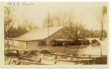
Photograph, Flooded Boat Shed in Kew, 1923, 1923
... floods - kew - 1923...One of three digital copies of flooded areas of Kew (1923-34), donated by Jan Coutts of Bulleen in 2019. ...1923 FLOODS / 14/10/1923 FLOODS...floods - kew - 1923 1923 FLOODS / 14/10/1923 FLOODS One of three digital copies of flooded areas of Kew (1923-34), donated by Jan Coutts of Bulleen in 2019. ...One of three digital copies of flooded areas of Kew (1923-34), donated by Jan Coutts of Bulleen in 2019. The handwriting on the originals predates the copy.1923 FLOODS / 14/10/1923 FLOODSfloods - kew - 1923 -
 Charlton Golden Grains Museum Inc
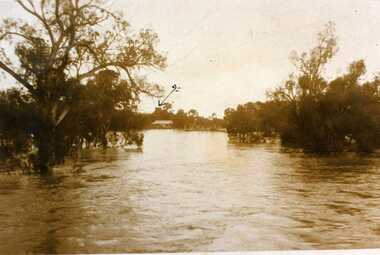
Photograph, 1923 Floods, 01/05/2008
... 1923 Floods...Floods 1923...(Looking accross river towards Tower on Clifton Hill) - The Tower is arrowed - 1st August 1923, Charlton Floods. The arrow indicates highest point in Charlton. ...Floods 1923 (Looking accross river towards Tower on Clifton Hill) - The Tower is arrowed - 1st August 1923, Charlton Floods. ...Unframed landscape Sepia(Looking accross river towards Tower on Clifton Hill) - The Tower is arrowed - 1st August 1923, Charlton Floods. The arrow indicates highest point in Charlton. The water tower in the middle of picture. Submerged backyards are visible only.floods 1923 -
 Charlton Golden Grains Museum Inc
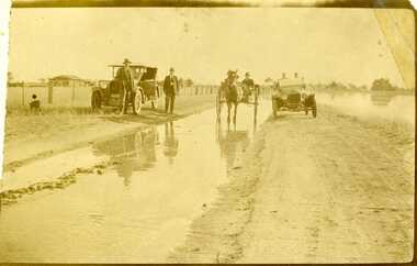
Photograph - 1923 Flood Charlton/St Arnaud Road, 01/05/2008
... 1923 Flood Charlton/St Arnaud Road...1923...Floods...Flood 1923 Charlton/St Arnaud Road. L-R car with 2 men standing nearby, horse & buggy in middle of road, another car with 2 people. ...Unframed landscape photo with dark border. Photograph 1923 Flood Charlton/St Arnaud Road ...5 miles out the St Arnaud Road near Roy Baker's old residence.Flood 1923 Charlton/St Arnaud Road. L-R car with 2 men standing nearby, horse & buggy in middle of road, another car with 2 people. Unframed landscape photo with dark border.St Arnaud Road flood near Roy Bakers old residence.1923, floods -
 Charlton Golden Grains Museum Inc
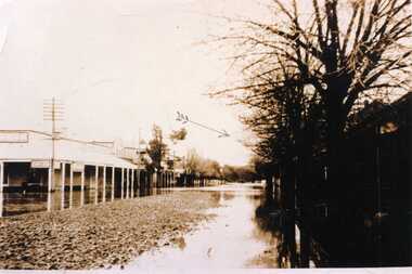
Photograph, 1923 Flood High Street Charlton (shows Tinsmith shop of William McConnell - arrowed)
... 1923 Flood High Street Charlton (shows Tinsmith shop of William McConnell - arrowed)...Floods 1923...1st August 1923. Floods Charlton - shows Tinsmith shop William McConnell, The flood water had started to fall when photo taken in the Mainstreet. ...Floods 1923 High St Charlton Tinsmith Shop William McConnell 1st August 1923. ...Landscape unframed sepia photo1st August 1923. Floods Charlton - shows Tinsmith shop William McConnell, The flood water had started to fall when photo taken in the Mainstreet. The water rose to 6 inches over the floor and boats were able to travel this street.floods 1923, high st charlton, tinsmith shop, william mcconnell -
 Charlton Golden Grains Museum Inc
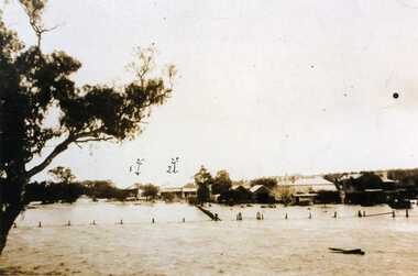
Photograph, 1923 Floods
... 1923 Floods...Taken from railway bridge Unframed landscape Photo 1923 Floods Photograph ...Unframed landscape PhotoAugust 1st, 1923 Charlton Vic. 3525. No. 1 arrow - Jim House - McConnell (later home of Elsa Paterson). No. 2 arrow - Mothers house - Nurse McConnell Private Hospital. Taken from railway bridgemcconnell private hospital -
 Charlton Golden Grains Museum Inc
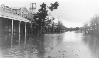
Photograph - Charlton Flood 1923
... Charlton Flood 1923 ...Charlton Flood 1923...1923 Charlton Flood...Black and white photo. 1923 Flood in High St Charlton, looking towards monument. ...1923 Charlton Flood Charlton Flood 1923 High St Charlton Black and white photo. 1923 Flood in High St Charlton, looking towards monument. ...1923 Charlton FloodBlack and white photo. 1923 Flood in High St Charlton, looking towards monument. Digital copy.charlton flood 1923, high st charlton -
 Wycheproof & District Historical Society Inc.
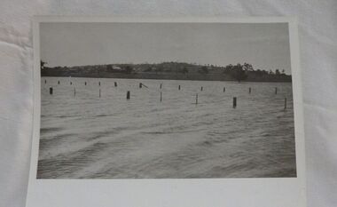
Photograph, Mr Ernie Taylor, Cooroopajerrup Creek 1923, 1923 (exact)
... 1923...cooroopajerrup creek...flood...Little is known of earlier records, but The Mount Wycheproof Ensign records flooding of the creek in 1909. 2011 saw the Cooroopajerrup flow again after 88 years. This 2011 photo was taken at about the same position as the 1923 photo. ...Copy of a B&W photograph of the Cooroopajerrup-Creek in flood-1923. To the north is Mount-Wycheproof, with the hospital barely visible behind the trees just left of centre, and a few scattered dwellings. ...The modern steel roadway fence is submerged. see-Photograph-Record No 001997. 1923 cooroopajerrup creek flood mount wycheproof None Copy of a B&W photograph of the Cooroopajerrup-Creek in flood-1923. ...The semi-mythical stream, the Cooroopajerrup Creek. Before there were any channel banks and formed roads, this creek shared the Avoca flood waters with the Tyrrell Creek. In more recent times the Wycheproof channel prevented the major floods of 1956 and 1973 from following the old river course. Also there is said to have been some shifting of the sand-hills at Teddywaddy which have blocked much of the old Cooroopajerrup flow. Little is known of earlier records, but The Mount Wycheproof Ensign records flooding of the creek in 1909. 2011 saw the Cooroopajerrup flow again after 88 years. This 2011 photo was taken at about the same position as the 1923 photo. The modern steel roadway fence is submerged. see-Photograph-Record No 001997.Copy of a B&W photograph of the Cooroopajerrup-Creek in flood-1923. To the north is Mount-Wycheproof, with the hospital barely visible behind the trees just left of centre, and a few scattered dwellings. The nearer railway-fence follows the road leading to the current saleyards.The outer fence has been replaced with a modern steel fence.None1923, cooroopajerrup creek, flood, mount wycheproof -
 Charlton Golden Grains Museum Inc
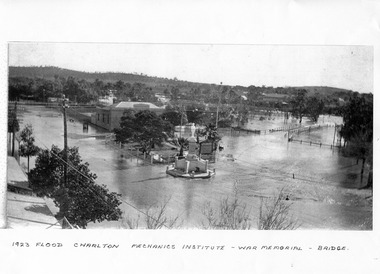
Photograph - 1923 Flood in Charlton
... 1923 Flood in Charlton...Photo is part of H.Narber's collection of the June 1923 flood...Photograph 1923 Flood in Charlton ...Photo taken of Charlton flood 1923, from Wylie's two storey building, looking west across the bridge. Photo includes the Mechanics Institute and triangular garden, recently built war memorial, and the wooden bridge across the Avoca River. Photo is part of H.Narber's collection of the June 1923 floodBlack and white photocopy of original photo. -
 Charlton Golden Grains Museum Inc
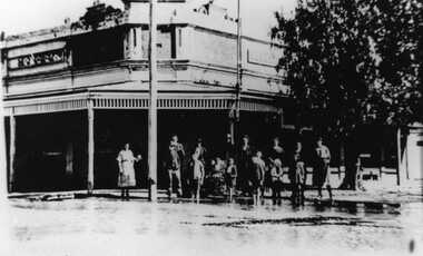
Photograph, 1923 Flood - Telegraph Hotel, Armstrong Street Charlton, c. 1923
... 1923 Flood - Telegraph Hotel, Armstrong Street Charlton...1923 Flood, Telegraph Hotel, Armstrong Street, Charlton, Victoria...1923 flood - Telegraph Hotel, Armstrong Street Charlton. ...1923 Flood, Telegraph Hotel, Armstrong Street, Charlton, Victoria Telegragh Hotel Charlton Livingstone Floods 1923 flood - Telegraph Hotel, Armstrong Street Charlton. ...1923 Flood, Telegraph Hotel, Armstrong Street, Charlton, Victoria1923 flood - Telegraph Hotel, Armstrong Street Charlton. Obituary: Charlton 100 years ago 18-02-1922 - 24/02/1922. Mr Francis Gilbert Livingstone passed away at Castlemaine on 14th ins. He was a very well known & highly respected old resident of Charlton & Narrewillock. Until October last he held the license of the Telegraph Hotel and was a familiar figure in his wheel chair under the shade trees at land at Narrewillock, where he farmed until failing health compelled him to give up the strenuous work of those early pioneering days, and in 1892 he took the license of the Telegraph Hotel which he retained until recently. He was 61 years of age.telegragh hotel, charlton, livingstone, floods -
 Charlton Golden Grains Museum Inc
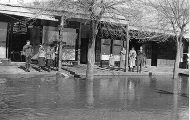
Photograph
... Flood 1923 High St Charlton, outside Wylie's store, taken by H. ...Flood 1923 High St Charlton, outside Wylie's store, taken by H. ...Flood 1923 High St Charlton, outside Wylie's store, taken by H. Barber. Beatrice Barber and daughters Elizabeth and Bernice standing outside his jewelers shop. A group of 4 is standing outside Wylie's general store, a 2 storey building.Black and white photocopy of the original photocharlton, business, floods, wylie's building -
 Charlton Golden Grains Museum Inc
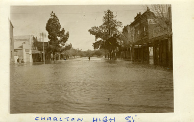
Postcard - Postcard of 1923 flood in Charlton, 1923
... Postcard of 1923 flood in Charlton....Sepia postcard of 1923 flood in Charlton. Looking west up High Street from Armstrong St corner. ...Charlton Floods High Street Sepia postcard of 1923 flood in Charlton. ...Sepia postcard of 1923 flood in Charlton. Looking west up High Street from Armstrong St corner. People standing in water.charlton, floods, high street -
 Charlton Golden Grains Museum Inc
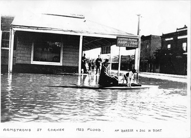
Photograph - 1923 Flood in Charlton
... 1923 Flood in Charlton...June 1923 Flood, photo of H.Barber and a dog in the boat. ...June 1923 Flood, photo of H.Barber and a dog in the boat. ...June 1923 Flood, photo of H.Barber and a dog in the boat. A group of 4 spectators watching at the corner of High and Armstrong St. Black and white photocopy of original photo -
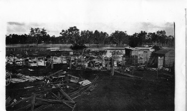 Charlton Golden Grains Museum Inc
Photograph - 1923 Flood in Charlton
... 1923 Flood in Charlton...Photo is part of a collection by H.Barber, Jeweller of the June 1923 flood, showing the backyard of Curnow's Garage on the west side of the bridge...Photo is part of a collection by H.Barber, Jeweller of the June 1923 flood, showing the backyard of Curnow's Garage on the west side of the bridge Black and white photocopy of original photo Photograph 1923 Flood in Charlton ...Photo is part of a collection by H.Barber, Jeweller of the June 1923 flood, showing the backyard of Curnow's Garage on the west side of the bridgeBlack and white photocopy of original photo -
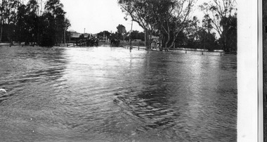 Charlton Golden Grains Museum Inc
Photograph - 1923 Flood in High St Charlton
... 1923 Flood in High St Charlton...June 1923 flood in High St, looking across the bridge from West Charlton. ...June 1923 flood in High St, looking across the bridge from West Charlton. ...June 1923 flood in High St, looking across the bridge from West Charlton. Part of a collection of photos taken by H.Barber.Black and white photocopy of original photo -
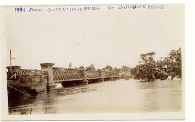 Kew Historical Society Inc
Photograph, Flooding of the Outer Circle Railway Bridge, 1934
... One of three digital copies of flooded areas of Kew (1923-34), donated by Jan Coutts of Bulleen in 2019. ...LUCKE UNDER THE TOP OF THE BRIDGE / NEE (MARY LUCKE) NOW TYACK One of three digital copies of flooded areas of Kew (1923-34), donated by Jan Coutts of Bulleen in 2019. ...One of three digital copies of flooded areas of Kew (1923-34), donated by Jan Coutts of Bulleen in 2019. The handwriting on the originals predates the copy.1934 FLOODS / OUTER CIRCLE BRIDGE / WE WENT UNDER BRIDGE OUTER CIRCLE BRIDGE / 1934 FLOODS / (DAD & I) / WE TOOK OUR CANOE UNDER THE BRIDGE, & CARL SIERAKOSKI WAS IN HIS CANOE AT THE TIME & WROTE DADS NAME A. LUCKE UNDER THE TOP OF THE BRIDGE / NEE (MARY LUCKE) NOW TYACKfloods - kew - 1934 -
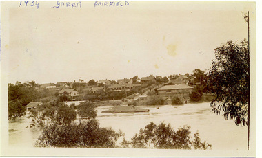 Kew Historical Society Inc
Photograph, Yarra at Fairfield, 1934 Floods, 1934
... One of three digital copies of flooded areas of Kew (1923-34), donated by Jan Coutts of Bulleen in 2019. ...floods - kew - 1934 1934 YARRA FAIRFIELD FROM OPPOSITE RUDDER GRANGE One of three digital copies of flooded areas of Kew (1923-34), donated by Jan Coutts of Bulleen in 2019. ...One of three digital copies of flooded areas of Kew (1923-34), donated by Jan Coutts of Bulleen in 2019. The handwriting on the originals predates the copy.1934 YARRA FAIRFIELD FROM OPPOSITE RUDDER GRANGE floods - kew - 1934 -
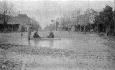 Charlton Golden Grains Museum Inc
Photograph - 1923 Flood in Charlton, High St
... 1923 Flood in Charlton, High St....Flood June 1923, part of H Barber's collection of photos. ...Flood June 1923, part of H Barber's collection of photos. ...Flood June 1923, part of H Barber's collection of photos. Taken beside the newly unveiled war memorial looking east down High St. There are 3 men, a dog and a boat in the photo. Left side of the street is Curnow's grocery store and CBA bank. Right side of the street is Barber's Jewellers and Wylie's general store.Black and white photocopy of original photo.charlton, floods -
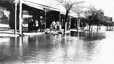 Charlton Golden Grains Museum Inc
Photograph - Photocopy
... 1923 flood, west end of High St. Spectators outside Wylie's store and Barber's jewellrey store. ...1923 flood, west end of High St. Spectators outside Wylie's store and Barber's jewellrey store. ...1923 flood, west end of High St. Spectators outside Wylie's store and Barber's jewellrey store. Photo taken by H. Barber Jeweller, part of a set of photos taken in June 1923.Black and white photocopy of original photofloods, business, high street, charlton -
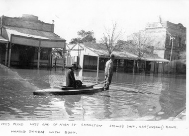 Charlton Golden Grains Museum Inc
Photograph - 1923 flood in Charlton
... 1923 flood in Charlton...Part of H.Barber's collection of June 1923 flood in Charlton. Photo taken from the west end of High St with Harold Barber towing a small boat and a passenger down the street. ...Black and white photocopy of original photo Photograph 1923 flood in Charlton ...Part of H.Barber's collection of June 1923 flood in Charlton. Photo taken from the west end of High St with Harold Barber towing a small boat and a passenger down the street. Buildings in the photo are Stowes's fruit shop and the Commercial Bank of Australasia.Black and white photocopy of original photo -
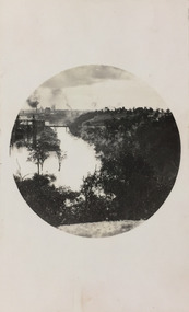 Kew Historical Society Inc
Photograph - Yarra River, Studley Park, 1924
... This photograph was taken during a flood year, perhaps 1923, when the Yarra encroached on the grounds of the Abbotsford Convent. ...This photograph was taken during a flood year, perhaps 1923, when the Yarra encroached on the grounds of the Abbotsford Convent. ...Henry Beater Christian (1886-1962) , was a descendant of one of the earliest settler families in Kew. Employed at the Kew Asylum as a 'public servant', he was a skilled amateur photographer, photographing numerous scenes in Kew and on his travels around Victoria. The majority of his photographs date from 1916 to 1929. His finest photographs are housed in two photograph albums. Digital copy of a photograph from page 7 of the 47-page photograph album containing 261 gelatinous silver images, loaned by Diane Washfold with permission given to digitise and hold a copy in our collection. This photograph was taken during a flood year, perhaps 1923, when the Yarra encroached on the grounds of the Abbotsford Convent. In the distance, the Johnston Street Bridge separates the viewer from the industrialised landscape of Fairfield. In developing the photo, Henry Christian employed a circular frame to artistically focus the view. He empkloyed this technique for what he may have viewed as his best photographs. "Studley Park / Kew"henry beater christian (1886-1962), landscape photography, kew (vic.) — yarra river, christian-washfold collection, photograph albums, fairfield, kew, johnston street bridge, studley park -
 Kew Historical Society Inc
Map, MMBW, River Yarra Beautification Schemes, c.1913
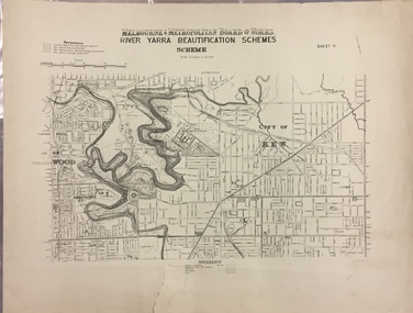
... The map shows development to date and the flood levels reached in 1923 and 1924. This map may have been adapted from an earlier map, as most development in central Kew and Studley Park had occurred by this date yet numerous streets are not represented. ...The map shows development to date and the flood levels reached in 1923 and 1924. This map may have been adapted from an earlier map, as most development in central Kew and Studley Park had occurred by this date yet numerous streets are not represented. ...The Melbourne and Metropolitan Board of Works (MMBW) was established by an act of the Victorian Parliament in 1890 to prepare for and to implement a sewerage and water reticulation system across what was then inner Melbourne, its surrounding and middle distance suburbs, including Kew. The MMBW was disbanded in 1991.The map collection of the Kew Historical Society has at its core the historic maps assembled and originally stored in the City Engineer's Department of the City of Kew. These include maps in a number of scales. The vast majority of maps were produced by the MMBW in the first two decades of the twentieth century, and are solid working maps, backed by linen for durability. These maps are historically significant to Kew, the City of Boroondara and to the history of the development of state utilities in Victoria. A number of the Kew maps have additional details added by former municipal officers, including the levels reached by various floods. As these were working documents, information was added to them long after the period of their initial production and distribution.Map of the City of Kew showing part of the River Yarra Beautification Schemes. The map shows development to date and the flood levels reached in 1923 and 1924. This map may have been adapted from an earlier map, as most development in central Kew and Studley Park had occurred by this date yet numerous streets are not represented. Public buildings and institutions are clearly represented and named on the map as are significant public transport infrastructure (eg the Outer Circle railway).MELBOURNE AND METROPOLITAN BOARD OF WORKS / RIVER YARRA BEAUTIFICATION SCHEMES / SCHEME / SCALE 10 CHAINS TO AN INCHmelbourne & metropolitan board of works, mmbw maps, mmbw plans, city of kew, flood levels -- kew (vic.), cartography -
 Eltham District Historical Society Inc
Photograph, Tess Justine (Nillumbik Shire Council), Murray's Bridge over the Diamond Creek, Eltham North, 19 Feb 2022
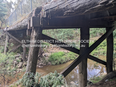
... . • In 1923 a new company was formed in anticipation of the old Diamond Creek Gold Mine being re-opened. The mine had been previously closed and flooded. .... • In 1923 a new company was formed in anticipation of the old Diamond Creek Gold Mine being re-opened. The mine had been previously closed and flooded. ...Murray's Bridge over the Diamond Creek on the Diamond Creek Trail just prior to demolition and replacement with a new steel bridge. Heritage advice obtained by Nillumbik Shire Council, following a suggestion by the Eltham District Historical Society (EDHS), is that the original bridge appears to have been a simplified version of the Country Roads Board’s (CRB) standard timber bridge design of the early-to-mid 1920s. In c1990 Murray’s bridge was renovated with three recycled steel girders as part of a bike/pedestrian path in the reserve. During these alterations many parts of the bridge were removed, and some were replaced. Heritage advice indicates the condition of Murray’s bridge is poor. The remaining original parts are all in poor condition, with severe weathering, splitting and rot, especially to the stringers retained on the bridge. Heritage advice is that Murray’s Bridge does not have sufficient significance in the cultural history of the Nillumbik area to warrant inclusion in the Nillumbik Shire Heritage Overlay and also does not have sufficient significance as a rare survivor to warrant inclusion in the Nillumbik Shire Heritage Overlay. There are no indications in the historical record that this site was individually important to the cultural history of this area. EDHS is comfortable with the heritage advice provided to Council and has worked closely on this project with Council. EDHS has suggested some of the removed timbers be used in the vicinity of the bridge for landscaping and possibly seating, so as to retain these remnants close to the site of the original bridge, which is the last old timber bridge along the lower reaches of the Diamond Creek. Mary (Sweeney) Murray and John Wright Murray selected 80 acres, Lot C Section 16 and Lot 5 Section 17 Parish of Nillumbik, under an occupation license in 1866. John died in 1867 and freehold was granted to his son John in 1873. The farm was known as ‘Laurel Hill’. John Junior was an Eltham Shire councillor and sometime president from 1887 up until 1897. He added Lot A Section 16 to the farm in ca1888. John and his younger brother James arranged to rent/purchase Lot B Section 17, across Diamond Creek to the west, in ca1900. It appears that John and James farmed separately for a few years, with a new homestead built for James ad family on the high point of Lot B Section 17 in ca1910. John sold off Lot 5 Section 17 in 1912. When John died in 1912 James took over the land on both sides of the Diamond Creek. The old homestead on the west side of the Creek disappeared. A farm bridge over Diamond Creek from this period may have been located close to the northern boundary of the farm. John Langlands, owner of the farm known as ‘Ihurst’ on the west side of Diamond Creek to the south of the Murray’s land, died in 1907. In 1909 his land was then subdivided into 100 lots to become the ‘Glen Park Estate’. Other similar subdivisions of nineteenth century farms around Eltham in this period included the ‘Franktonia (or Beard’s) Estate’ to the northeast and ‘Bonsack’s Estate’ between Eltham and Greensborough. Soon after the opening of the railway extension line from Eltham to Hurstbridge in 1912, Glen Park and nearby residents including James Murray agitated for a railway station or siding to be located half-way between Eltham and Hurstbridge, so that the Glen Park residents who used the railway daily did not have to walk into the Eltham or Hurstbridge stations. Some believed Coleman’s Corner (opposite Edendale Farm) was an appropriate spot for the platform. James Murray was among those who thought the railway should be located on his land, closer to half-way between Eltham and Hurstbridge stations. The Railways Commissioners warned that the locals would have to fund these works themselves. The Glen Park Estate residents initially had difficulty accessing Eltham by road, with only an old low-level bridge over Diamond Creek at the south end of their estate. A new timber trestle bridge across the creek, now on Wattletree Road, was opened in 1915. Road access to the north was gained in 1927 when the new Murray’s Road, which crossed the Murray’s land, was built. Residents continued to agitate for a Glen Park station. By 1926 the Railways Commissioners’ preferred site was on the Murray’s land. They arranged an estimate of cost of a full-length platform. The estimate was too much for the locals, who in 1928 argued unsuccessfully for a shorter and hence cheaper platform. By 1929 Murray had agreed to donate the land, but the locals would still have to fund the works. Murray decided, unilaterally it would appear, to commence work on a timber trestle road bridge over Diamond Creek to link the new Murray Road to the proposed station. Late in 1929 he stopped work on the bridge, for reasons unknown, but started work again and completed the bridge in 1931. There is no further newspaper evidence of the campaign for the Glen Park station until 1939, when Murray and another local, Mr Maxwell, met the Railways Commissioner. The Glen Park locale now included 45 homes on the west side of the creek and 20 on the Eltham side. Most of the residents used the train every day. The Commissioner remained adamant that only a full-length platform could be built for safety reasons. It appears the campaign dissolved at this point. The increasing move to cars may have had an impact. There is no evidence of Murray’s bridge ever being connected to Murray’s Road, or of it having wide use for any purpose by locals. James Murray died in 1947 and the farm was taken over by his son James (Jim). Jim started to sell off parts of the farm in the 1980s, retaining a few acres around the ca1910 homestead and building a new house there. Recreation reserves were established along the creek. In ca1990 Murray’s bridge was renovated with steel girders as part of a bike/pedestrian path in the reserve. The old farmhouse was demolished in ca2014. * * * A theory posted on local community Facebook groups was that the bridge was built in the 1860s and was built to be more robust than was necessary for the movement of cows from one side of the creek to the other. It was suggested the robustness was necessary to support the weight of gold ore being transferred from a mine on Murray’s land to a railway siding near Murrays Bridge (presumably for transfer and processing at Diamond Creek). Perhaps this may have been one of the motivators for Murray, who really knows? Knowing when mining operations ceased on his land and how that fits the overall timeline would be useful but at the time the bridge was built, local gold production was minimal at best. The known facts are: • The railway line came to Eltham in 1902. • The extension of the railway from Eltham to Hurstbridge was constructed in 1912 so no railway line even existed through Murray's property until 1912 and the Victorian Railways maps at the time show no such siding on Murray’s property. • In 1923 a new company was formed in anticipation of the old Diamond Creek Gold Mine being re-opened. The mine had been previously closed and flooded. It was noted in the press at the time that the mine was within a mile of the railway. Nothing really came of this. • Construction of Murrays Bridge was commenced by James Murray in early 1929 in anticipation of a proposed flag station being nominated on his land, but work ceased shortly afterwards. The proposed flag station was commonly referred to as Glen Park as the residents of the Glen Park Estate wanted Option 1, located near them with the platform adjacent to Colemans corner. This was probably never going to fly as it was virtually in eyesight of Eltham station. Allandale Road was the third option, but the Commissioners' preferred option was No. 2 - on Murray's property. • The Railway Commissioners were not going to finance any such station and the works had to be funded by private landowners and residents, hence Murray investing in this himself. • Murray recommenced work two years later and finished his bridge in 1931 but unfortunately for him, the proposed flag station never eventuated. The bluestone siding you reference may well have been built by Murray as part of the proposed station platform. • Up until then, apart from the Main Road bridge, which was washed away in 1924, virtually all local crossings over the Diamond Creek were low lying bridges – Kaylocks Bridge at Brougham Street, Diamond Street bridge, Glen Park Road bridge. It is expected that Murray also had a low-lying bridge to connect his land either side of the creek. These were all washed away or severely damaged multiple times in the 1920s. Lessons were learnt, and Murrays Bridge appears to have been built in accordance with Country Road Board standards of the time. Flood damage was ongoing, and even more recently constructed raised bridges kept getting washed away, e.g., the new Wattle Tree Road bridge in 1958 just months after completion. Murray’s bridge was reinforced with steel some 30 years ago presumably to provide additional floodwater resistance, given the history of bridges disappearing in floodwaters. • In March 1932 it was reported in the Advertiser that there were still some prospectors operating around Eltham North who apart from further scarring the face of the earth over the previous two years had gained significant experience but little gold - hardly a driving factor for constructing a dedicated railway siding and bridge to transfer gold ore. It is far more probable that James Murray was hoping to have the railway station located on his property and invested his money by building the bridge to lead to it as well as a station platform. Had the station eventuated, it may well have driven up the value of his land for subdivision and new housing estates like the Glen Park Estate. That did not eventuate. Whilst the bridge was indeed old (90 years), the core structure being completed in 1931, it had been modified substantially from original and hence had no significant historic value – i.e., it was not a representative example of its type, construction, and age. Given that the bridge was not worthy of saving, the Eltham District Historical Society with Council’s support, and the Eltham Woodworkers group endeavoured to see what suitable sized timbers were salvageable to fabricate a commemorative seat. Unfortunately, the experts at the Woodworkers group were unable to salvage any suitable length/width timbers to fabricate the seat due to the presence of rot. Last remaining wooden trestle bridge on the Diamond Creek Trail just prior to demolition and replacementBorn digital image (27)diamond creek (creek), diamond creek trail, murrays bridge, ‘laurel hill’, john wright murray, mary (sweeney) murra, john murray jnr, james murray, john langlands, ‘ihurst’, ‘glen park estate’, beard's estate, franktonia, bonsack's estate, glen park estate, glen park railway station -
 Eltham District Historical Society Inc
Negative - Photograph, The Rose Stereograph Company, Diamond Creek, Eltham, Vic, c.1919
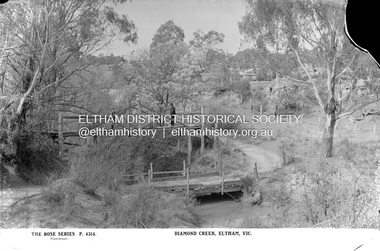
... flood. The railway came to Eltham in 1901, the Eltham Railway Station is visible in the distance as well as a wooden bodied Tait (Red Rattler) First Class train carriage. The Tait train was first introduced in 1910 as a steam locomotive hauled carriage and in 1919 electric motor carriages were introduced however the line to Heidelberg was not electrified till 1921 and to Eltham in April 1923. ...flood. The railway came to Eltham in 1901, the Eltham Railway Station is visible in the distance as well as a wooden bodied Tait (Red Rattler) First Class train carriage. The Tait train was first introduced in 1910 as a steam locomotive hauled carriage and in 1919 electric motor carriages were introduced however the line to Heidelberg was not electrified till 1921 and to Eltham in April 1923. ...Shows two bridge crossings over the Diamond Creek in Diamond Street, Eltham. The upper pedestrian crossing provided continual access for foot traffic during times of flood. The railway came to Eltham in 1901, the Eltham Railway Station is visible in the distance as well as a wooden bodied Tait (Red Rattler) First Class train carriage. The Tait train was first introduced in 1910 as a steam locomotive hauled carriage and in 1919 electric motor carriages were introduced however the line to Heidelberg was not electrified till 1921 and to Eltham in April 1923. The Railway General Store on Main Road is visible beyond the station and was built by Luther Haley in 1902. It was the first shop in the present day shopping centre. It was later known as lloyd's stopre (1917-1920) followed by a succession of six other owners until purchased by Eric Staff in 1939. This glass plate negative was used to manufacture postcards (1:1 printing) for commercial sale by the Rose Sterograph Company and its subsidiaries. George Rose founded the Rose Stereograph Company in 1880 and was joined by Herbert (Bert) Cutts in the early 20th Century. The pair formed a lifetime working partnership and strong personal friendship. Assisted by George’s two sons, Herbert George and Walter, and later by Neil Cutts, the Rose Stereograph Company continued its operations for more than 140 years. The company was initially built on stereographs, but as cinema took over and stereographs fell out of fashion, the Rose Stereograph Company developed Australia’s first commercially viable photographic postcard business. Specialising in postcards of iconic historical moments and significant landmarks, The Rose Stereograph Company became a staple of the Australian travel industry.This remarkable collection of glass plate negatives, transparencies, and postcards – arguably Australia’s most significant photography collection outside of public hands – has been passed down through the generations, surviving war, relocation, and the harsh Victorian climate. The historic Rose Stereograph collection is the culmination of George Rose’s dream of capturing and preserving precious moments in time and remains the legacy of the Rose and Cutts families. It is with great sadness that the Cutts family says goodbye to a collection that spans five generations and 140 years. The Cutts family understands that for these historically important pieces to rest with one family is to deny others the pleasure of their custodianship.Glass Plate Negative Size: 9 x 13.9 cmDiamond Creek, Eltham, Vic., The Rose Series P. 4314, Copyrighteltham, postcard, travel, rose stereograph company, glass plate negative, rose series postcard, tait train, eltham railway station, railway store, staffs general store, diamond creek, diamond street bridge, lloyd's general store, railway station, peter and elizabeth pidgeon collection -
 Eltham District Historical Society Inc
Negative - Photograph, Harry Gilham, Grave of Richard George, Emily Ann (nee Davis) and Edith Jane Kaylock, Eltham Cemetery, Victoria, Sep 2009
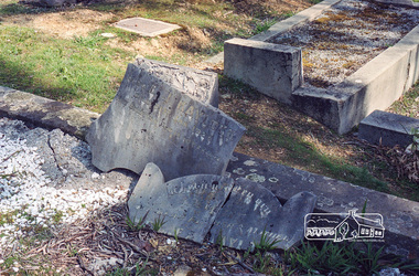
... Its low level and insubstantial construction made it susceptible to flood damage, necessitating frequent closures until repairs could be carried out. The original bridge was demolished in 1923 and replaced by a "new up-to-date" one. ...Its low level and insubstantial construction made it susceptible to flood damage, necessitating frequent closures until repairs could be carried out. The original bridge was demolished in 1923 and replaced by a "new up-to-date" one. ...In his early adult life, Richard Kaylock worked as a whaler (visiting California and New Zealand) and later as a drover on a large cattle station in New South Wales. In 1848 he came to Melbourne, working as a slaughterman, then settled in Eltham in 1854, his occupation thereafter being variously recorded as butcher or orchardist. He also had some experiences at Ballarat during the Eureka Rebellion. He died in 1910 at the age of 84. His obituary described him as a "striking personality" who was "brusque to a fault" and "strictly upright, expecting others to be the same". It seems from his will that he was illiterate. He is buried in Eltham Cemetery with his wife Emily. His property was in Wellington Street (now Brougham Street) and apparently extended across the Diamond Creek. The land on the western side of the creek was farmed, the house being on the eastern side. For many years the Brougham Street bridge was generally known as "Kaylock's Bridge". It formed part of the original coach road to Eltham and in 1922 was described as an "old rustic bridge". Its low level and insubstantial construction made it susceptible to flood damage, necessitating frequent closures until repairs could be carried out. The original bridge was demolished in 1923 and replaced by a "new up-to-date" one. When a lack of finances delayed repairs to the Bridge Street bridge in 1931, traffic had to detour via Brougham Street for some time. Local residents feared that the Bridge Street bridge might never reopen. In Loving Memory Of Our Dear Father & Mother R.G. and E.A. Kaylock Also E.J. Kaylock Died 21st Jan. 1927 The Eternal God Is My PledgeRoll of 35mm colour negative film, 6 stripsKodak GC 400-9eltham cemetery, gravestones, edith jane kaylock, emily ann kaylock (nee davis), richard george kaylock, brougham street bridge, kaylocks bridge -
 Eltham District Historical Society Inc
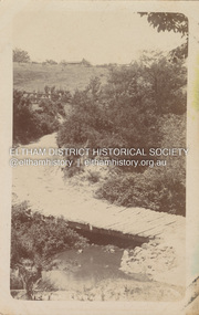
Postcard - Photograph postcard, Old Bridge, Kaylock's Crossing, Brougham Street, Eltham, c.1912
... flood damage. The tender was awarded to Mr Weller of Kangaroo Ground who commenced work in February 1923 on a higher-level timber trestle bridge. ...flood damage. The tender was awarded to Mr Weller of Kangaroo Ground who commenced work in February 1923 on a higher-level timber trestle bridge. ...Date estimated to be circa 1912 based on the style of printing on the reverse of the card - Kodak Austral paper for real photo postcards, the paper was manufactured c.1908-1914 (See also POSTCARDS ON KODAK PAPER - IS IT POSSIBLE TO "DATE" THEM? http://tps.org.au/bb/viewtopic.php?t=115) Brougham Street was created in Josiah Holloway's 1851 subdivision of Little Eltham. It was one of several east-west streets shown on the subdivision plan as crossing the Diamond Creek. The western part was named Wellington Street on the subdivision plan but was later changed to conform with the name of the eastern part as acknowledgement of the continuity of the street. It is not known when the first bridge was constructed in Brougham Street however it was certainly mentioned at Council’s meeting of 2 June 1884 as being in a dangerous state of repair. This photo (c.1895) of an old bridge shows a very low-level simple log girder bridge crossing the creek at a right angle and so the approaches involved bends in the road alignment. This bridge was generally known as Kaylocks Bridge or Kaylock’s Crossing after the owner of the adjoining land. It was most likely built from around the mid-1850s, or a crossing of some fashion established as Richard George Kaylock, butcher of Little Eltham and his wife Emily Ann settled there in 1854. His property was in Wellington Street (now Brougham Street) and apparently extended across the Diamond Creek. The land on the western side of the creek was farmed, the house being on the eastern side. Kaylock's Bridge formed part of the original coach road to Eltham and in 1922 was described as an "old rustic bridge". Its low level and insubstantial construction made it susceptible to flood damage, necessitating frequent closures until repairs could be carried out. In September 1922, Council called for tenders for a new timber bridge to be constructed at Kaylock’s crossing. An engineering assessment carried out for the Council by Macleod Consulting at the time of the replacement suggested that the construction details indicate that it was in the 1900s, however this dating could possibly have been the result of numerous repairs undertaken over the years to flood damage. The tender was awarded to Mr Weller of Kangaroo Ground who commenced work in February 1923 on a higher-level timber trestle bridge. Work was slowed due to illness of the contractor and the accidental death of a man in March 1923 following the collapse of the bank after he had jumped into a hole that had just been blasted. The bridge was completed around July 1923 at which point the old structure was pulled up, marking what was described in the ‘Advertiser’ newspaper as the passing of an old and well-loved landmark in the district. In April 1924 the approach to Kaylocks bridge was washed away during the heavy flooding that destroyed the Main Road bridge. The western side was repaired, and an extra span was added to the eastern side using timber from the destroyed Main Road bridge. The bridge was again severely damaged four months later in August 1924 When a lack of finances delayed repairs to the Bridge Street bridge in 1931 (also referred to as Obelisk Bridge at the time), traffic had to detour via Brougham Street for some time. Local residents feared that the Bridge Street bridge might never reopen. Kaylocks Bridge was constantly subject to damage by floods. In the 1934 flood it was submerged by two feet of water. In more recent times the bridge was again severely damaged by flooding and repairs made. A new bridge and adjoining footbridge were constructed in 2009.Digital file only Postcards scanned from the collection of Michael Aitken on loan to EDHS, 2 Sep. 2022michael aitken collection, eltham, postcards, bridge, brougham street, diamond creek (creek), kaylocks bridge, wellington street -
 Eltham District Historical Society Inc
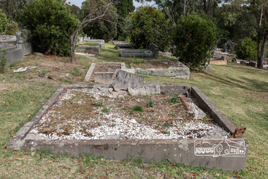
Photograph, Peter Pidgeon, Grave of Richard George, Emily Ann (nee Davis) and Edith Jane Kaylock, Eltham Cemetery, Victoria, 5 April 2021
... Its low level and insubstantial construction made it susceptible to flood damage, necessitating frequent closures until repairs could be carried out. The original bridge was demolished in 1923 and replaced by a "new up-to-date" one. ...Its low level and insubstantial construction made it susceptible to flood damage, necessitating frequent closures until repairs could be carried out. The original bridge was demolished in 1923 and replaced by a "new up-to-date" one. ...In his early adult life, Richard Kaylock worked as a whaler (visiting California and New Zealand) and later as a drover on a large cattle station in New South Wales. In 1848 he came to Melbourne, working as a slaughterman, then settled in Eltham in 1854, his occupation thereafter being variously recorded as butcher or orchardist. He also had some experiences at Ballarat during the Eureka Rebellion. He died in 1910 at the age of 84. His obituary described him as a "striking personality" who was "brusque to a fault" and "strictly upright, expecting others to be the same". It seems from his will that he was illiterate. He is buried in Eltham Cemetery with his wife Emily. His property was in Wellington Street (now Brougham Street) and apparently extended across the Diamond Creek. The land on the western side of the creek was farmed, the house being on the eastern side. For many years the Brougham Street bridge was generally known as "Kaylock's Bridge". It formed part of the original coach road to Eltham and in 1922 was described as an "old rustic bridge". Its low level and insubstantial construction made it susceptible to flood damage, necessitating frequent closures until repairs could be carried out. The original bridge was demolished in 1923 and replaced by a "new up-to-date" one. When a lack of finances delayed repairs to the Bridge Street bridge in 1931, traffic had to detour via Brougham Street for some time. Local residents feared that the Bridge Street bridge might never reopen. In Loving Memory Of Our Dear Father & Mother R.G. and E.A. Kaylock Also E.J. Kaylock Died 21st Jan. 1927 The Eternal God Is My PledgeBorn Digitaleltham cemetery, gravestones, brougham street bridge, edith jane kaylock, emily ann kaylock (nee davis), kaylocks bridge, richard george kaylock -
 Eltham District Historical Society Inc
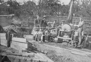
Photograph, Construction of the new concrete bridge over the Diamond Creek on Main Road, Eltham, c.May 1926
... The original long suspension bridge over the Diamond Creek on Main Road at Eltham collapsed during flooding of the Diamond Creek on October 13 and 14, 1923. The original bridge was built around 1840 for the coach road when Cobb & Co.'...The original long suspension bridge over the Diamond Creek on Main Road at Eltham collapsed during flooding of the Diamond Creek on October 13 and 14, 1923. The original bridge was built around 1840 for the coach road when Cobb & Co.' ...Construction of the new concrete bridge over the Diamond Creek on Main Road, Eltham, c.May 1926. Viewed from northern approach looking east, the access drive running off Antoinette Boulevard parallel to Main Road is visible as well as the power lines that used to run in front of Eltham Park (Eltham Lower Park). Also visible is a tree situated beside the roadway. It is believed this is the same tree that remains today as a dead tree trunk immediately adjacent to the road verge armco near the corner of Antoinette Boulevard. The original long suspension bridge over the Diamond Creek on Main Road at Eltham collapsed during flooding of the Diamond Creek on October 13 and 14, 1923. The original bridge was built around 1840 for the coach road when Cobb & Co.'s coach was the only conveyance between Eltham and Melbourne. Widespread damage was done in Melbourne and surrounding areas by floods resulting from the overflow of the Yarra at many points along its banks. A temporary bridge rigged up was severely damaged by the flooding of the creek and was closed to vehicular traffic in April 1924. A new concrete bridge was constructed to replace it and by May 1926 all the concrete piles and abutments had been completed. The bridge was finally completed and opened for traffic in September 1926, almost three years after it initially collapsed.This photo forms part of a collection of photographs gathered by the Shire of Eltham for their centenary project book,"Pioneers and Painters: 100 years of the Shire of Eltham" by Alan Marshall (1971). The collection of over 500 images is held in partnership between Eltham District Historical Society and Yarra Plenty Regional Library (Eltham Library) and is now formally known as the 'The Shire of Eltham Pioneers Photograph Collection.' It is significant in being the first community sourced collection representing the places and people of the Shire's first one hundred years.Photo print 9 x 12.5 cmshire of eltham pioneers photograph collection, eltham, bridge, diamond creek (creek), eltham south, main road bridge, wingrove park, antoinette boulevard, significant tree, cement mixer, bridge construction -
 Kiewa Valley Historical Society
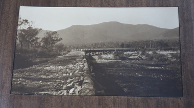
Photos - Tawonga Bridge x 2
... It was destroyed by floods in 1916. The new bridge was constructed in 1923 and destroyed in 1953. ...It was destroyed by floods in 1916. The new bridge was constructed in 1923 and destroyed in 1953. ...The first Tawonga bridge was built in 1884. It was destroyed by floods in 1916. The new bridge was constructed in 1923 and destroyed in 1953. The present concrete bridge was constructed in 1986 and named Ryders Bridge. Also refer to ?KVHS 0962 and KVHS 1051, KVHS 1090, KVHS 1123Bridge constructed over the Kiewa River in 1923 and destroyed in 1953.1. Dark Brownish photo framed by thin wood. Photo shows bridge with mountain behind and river and river bank in the foreground. 2. Small photo showing 2 sides of the bridge - a close up view.tawonga bridge, kiewa valley, kiewa river -
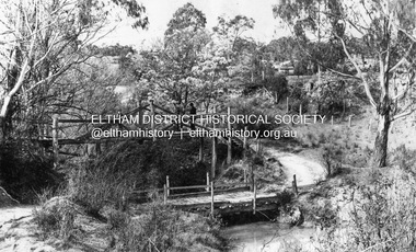 Eltham District Historical Society Inc
Negative - Photograph, Diamond Creek, Eltham. Old Diamond Street Bridge
... flood. The railway came to Eltham in 1901, the Eltham Railway Station is visible in the distance as well as a wooden bodied Tait (Red Rattler) First Class train carriage. The Tait train was first introduced in 1910 as a steam locomotive hauled carriage and in 1919 electric motor carriages were introduced however the line to Heidelberg was not electrified till 1921 and to Eltham in April 1923. ...flood. The railway came to Eltham in 1901, the Eltham Railway Station is visible in the distance as well as a wooden bodied Tait (Red Rattler) First Class train carriage. The Tait train was first introduced in 1910 as a steam locomotive hauled carriage and in 1919 electric motor carriages were introduced however the line to Heidelberg was not electrified till 1921 and to Eltham in April 1923. ...Copy of Rose Series Postcard P. 4314. (The Rose Stereograph Company) Shows two bridge crossings over the Diamond Creek in Diamond Street, Eltham. The upper pedestrian crossing provided continual access for foot traffic during times of flood. The railway came to Eltham in 1901, the Eltham Railway Station is visible in the distance as well as a wooden bodied Tait (Red Rattler) First Class train carriage. The Tait train was first introduced in 1910 as a steam locomotive hauled carriage and in 1919 electric motor carriages were introduced however the line to Heidelberg was not electrified till 1921 and to Eltham in April 1923. The Railway General Store on Main Road is visible beyond the station and was built by Luther Haley in 1902. It was the first shop in the present day shopping centre. It was later known as lloyd's stopre (1917-1920) followed by a succession of six other owners until purchased by Eric Staff in 1939. George Rose founded the Rose Stereograph Company in 1880 and was joined by Herbert (Bert) Cutts in the early 20th Century. The pair formed a lifetime working partnership and strong personal friendship. Assisted by George’s two sons, Herbert George and Walter, and later by Neil Cutts, the Rose Stereograph Company continued its operations for more than 140 years. The company was initially built on stereographs, but as cinema took over and stereographs fell out of fashion, the Rose Stereograph Company developed Australia’s first commercially viable photographic postcard business. Specialising in postcards of iconic historical moments and significant landmarks, The Rose Stereograph Company became a staple of the Australian travel industry.This photo forms part of a collection of photographs gathered by the Shire of Eltham for their centenary project book,"Pioneers and Painters: 100 years of the Shire of Eltham" by Alan Marshall (1971). The collection of over 500 images is held in partnership between Eltham District Historical Society and Yarra Plenty Regional Library (Eltham Library) and is now formally known as 'The Shire of Eltham Pioneers Photograph Collection.' It is significant in being the first community sourced collection representing the places and people of the Shire's first one hundred years.Digital image 4 x 5 inch B&W Negdiamond creek, diamond street bridge, eltham, eltham railway station, glass plate negative, lloyd's general store, postcard, railway station, railway store, rose series postcard, rose stereograph company, shire of eltham pioneers photograph collection, staffs general store, tait train, travel -
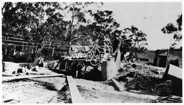 Eltham District Historical Society Inc
Negative - Photograph, Construction of the new concrete bridge over the Diamond Creek on Main Road, Eltham, c.May 1926
... The original long suspension bridge over the Diamond Creek on Main Road at Eltham collapsed during flooding of the Diamond Creek on October 13 and 14, 1923. The original bridge was built around 1840 for the coach road when Cobb & Co.'...The original long suspension bridge over the Diamond Creek on Main Road at Eltham collapsed during flooding of the Diamond Creek on October 13 and 14, 1923. The original bridge was built around 1840 for the coach road when Cobb & Co.' ...Construction of the new concrete bridge over the Diamond Creek on Main Road, Eltham, c.May 1926. Viewed from northern approach looking south east towards Eltham Park (Eltham Lower Park), showing the power lines that used to run in front of the park. The original long suspension bridge over the Diamond Creek on Main Road at Eltham collapsed during flooding of the Diamond Creek on October 13 and 14, 1923. The original bridge was built around 1840 for the coach road when Cobb & Co.'s coach was the only conveyance between Eltham and Melbourne. Widespread damage was done in Melbourne and surrounding areas by floods resulting from the overflow of the Yarra at many points along its banks. A temporary bridge rigged up was severely damaged by the flooding of the creek and was closed to vehicular traffic in April 1924. A new concrete bridge was constructed to replace it and by May 1926 all the concrete piles and abutments had been completed. The bridge was finally completed and opened for traffic in September 1926, almost three years after it initially collapsed.This photo forms part of a collection of photographs gathered by the Shire of Eltham for their centenary project book,"Pioneers and Painters: 100 years of the Shire of Eltham" by Alan Marshall (1971). The collection of over 500 images is held in partnership between Eltham District Historical Society and Yarra Plenty Regional Library (Eltham Library) and is now formally known as the 'The Shire of Eltham Pioneers Photograph Collection.' It is significant in being the first community sourced collection representing the places and people of the Shire's first one hundred years.Digital image 4 x 5 inch B&W Negshire of eltham pioneers photograph collection, bridge, bridge construction, cement mixer, diamond creek (creek), eltham, eltham lower park, eltham south, main road bridge
