Showing 162 items matching "gippsland highway"
-
 Lakes Entrance Historical Society
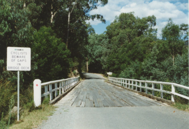
Photograph - Bonang Highway, East Gippsland Victoria, Marie Fish, Martins Creek Bridge, 1990 c
... Bonang Highway, East Gippsland Victoria...Colour photograph of wooden bridge over Martins Creek on Bonang Highway East Gippsland Victoria...Lakes Entrance Historical Society 4 Marine Parade Lakes Entrance gippsland Bridges riv Roads and Streets Engineering Colour photograph of wooden bridge over Martins Creek on Bonang Highway East Gippsland Victoria Martins Creek Bridge Photograph Bonang Highway, East Gippsland Victoria Marie Fish ...Colour photograph of wooden bridge over Martins Creek on Bonang Highway East Gippsland Victoriabridges, riv, roads and streets, engineering -
 Federation University Historical Collection
Reports, Big Cats Sightings and Stock Kills 2000-2011, 2000-2011
... ...south Gippsland Highway...The folder was collected for research being conducted by David Waldron. australian mythical animals collection david waldron Department of Primary Industries rangers peter walsh Warragul creek Binginwarri Coongulla Straford Licola Blanket Hill Darramin Blanket Hill Woodside BEach heyfield puma panther cowwarr glenmaggie bolands bluff darrimen bolands bluff binginnwarri dawson the springs mt taylor black range driffield west Snowy plains airstrip glenmaggie north jack smith lake munro briagaling dutson downs connors plain giffard west darriment Joyces Road Junction Giffard West wallaby creek south Gippsland Highway avon river orbost four mile creek Folder of reports of Big Cat by rangers. ...The folder or correspondence is the result of a Freedom of Informaition request made to the Department of Primary Industries in 2011. The folder was collected for research being conducted by David Waldron.Folder of reports of Big Cat by rangers. australian mythical animals collection, david waldron, department of primary industries, rangers, peter walsh, warragul creek, binginwarri, coongulla, straford, licola, blanket hill, darramin, blanket hill, woodside beach, heyfield, puma, panther, cowwarr, glenmaggie, bolands bluff, darrimen, bolands bluff, binginnwarri, dawson, the springs, mt taylor, black range, driffield west, snowy plains airstrip, glenmaggie north, jack smith lake, munro, briagaling, dutson downs, connors plain, giffard west, darriment, joyces road junction, giffard west, wallaby creek, south gippsland highway, avon river, orbost, four mile creek -
 Phillip Island Conservation Society Inc.
Work on paper - Photocopy of newspaper cutting, "PHILLIP ISLAND/A place to fall in love"
... ...Gippsland Highway...Phillip Island Cape Woolamai Penguin Parade Seal rocks Nobbies Township of Rhyll Phillip Island Princes Highway Dandenong Pakenham Kooweerup Carinya Creek Officer San Remo Gippsland Highway Holiday homes Fort Dumaresq Kitty Miller's beach Wreck of the Speke Hereford cattle Fleetwood Manor Koalas Ventnor Eric Juckert Little Penguin behaviour Photocopy of full page article with 5 columns of text, a map and 2 photographs. ...This article was written by an English visitor named Elsa Christian who was touring Australia and New Zealand with her husband Frank in their own small van. The article was published in the Australian Women’s Weekly, magazine, March 1966. Elsa writes she wanted to visit four Australian locations before she died: Ayers Rock (actually Uluru), the Snowy River project, dolphins at Coolangatta and the Penguin Parade at Phillip Island. These destinations were all very popular in the 1960s for both Australian residents and overseas visitors. Because the roads were becoming better too many locations, self guided tours in small vans for cars towing bond would caravans were becoming more popular means of seeing AustraliaThe article is significant in many ways. 1. Indicates the places English visitors commonly wish to see in Australia. 2. Describes the growing trend to self- drive van/camping holidays. 3. Gives the route taken from Melbourne to Phillip Island during the 1960s. 4. Describes the appearance of the roadsides and locations visited. 5. It is written in a descriptive and lyrical style designed to appeal to Women’s Weekly magazine readers, who were probably wondering how they could visit Phillip Island with their husbands or families themselves, and what there was to see there. 6. Gives the visitors’ view of how the Penguin Parade operated at the time. 7. Includes a description of potter and artist Eric Juckert’s renowned garden at Grossard Point, Ventnor. 8. Indicates how introduced plants such as Hawthorn pushes and Kate weed were common in the area. 9. Describes Phillip Island as “a place to fall in love” because of its natural beauty, fauna and coastal seascapes. 10. As a visitor Elsa describes the housing estates as a blot on the landscape, but also sees the value as a way of their owners escaping from the hustle and bustle of Melbourne. 11. Gives the visitors’ interpretation of the behaviour of wildlife the RC in the wild, as well as Elsa’s knowledge about some of the species she encounters.Photocopy of full page article with 5 columns of text, a map and 2 photographs. Black ink on white paper. Photographs blackened in photocopying processphillip island, cape woolamai, penguin parade, seal rocks, nobbies, township of rhyll phillip island, princes highway, dandenong, pakenham, kooweerup, carinya creek, officer, san remo, gippsland highway, holiday homes, fort dumaresq, kitty miller's beach, wreck of the speke, hereford cattle, fleetwood manor, koalas, ventnor, eric juckert, little penguin behaviour -
 Orbost & District Historical Society
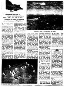
black and white photograph, 1920s
... woodcarving Pons-Asinorum Boulder-Creek-East-Gippsland Princess-Highway...The carving is no longer there. woodcarving Pons-Asinorum Boulder-Creek-East-Gippsland Princess-Highway on front at bottom - ON THE ORBOST CANN ROAD A small black / white photograph of a face carved into a tree stump. black and white photograph ...Pons asinorum was the name given to a wooden carving made by road worker Finlay Munro in the early 1920s at Boulder Creek, on the old Princess Highway, between Orbost and Cann River. The carved face was said to mock the supervising engineer after an argument about putting the road alignment across a swamp that required new bridges. The Italian workmen had advocated for a different route to avoid the need for building new bridges across the swamp. This photograph is from a set of thirteen black and white postcards in a fold-out format.This is a photograph of an iconic tourist attraction which records the woodworking skills of workers in the early 20th century. The carving is no longer there.A small black / white photograph of a face carved into a tree stump.on front at bottom - ON THE ORBOST CANN ROADwoodcarving pons-asinorum boulder-creek-east-gippsland princess-highway -
 Lakes Entrance Historical Society
Photograph - Bridges, 2003
... Colour photograph showing information boards giving the history of the iconic bridge and its relationship to the Gippsland Lakes historic swing bridge over the Latrobe River. The South Gippsland Highway no longer uses the swing bridge since two new bridges have been built a little upstream on the Latrobe River. ...Bridges Waterways Local History Display Colour photograph showing information boards giving the history of the iconic bridge and its relationship to the Gippsland Lakes historic swing bridge over the Latrobe River. The South Gippsland Highway no longer uses the swing bridge since two new bridges have been built a little upstream on the Latrobe River. ...Also thirteen other photographs showing bridge open and closed.Colour photograph showing information boards giving the history of the iconic bridge and its relationship to the Gippsland Lakes historic swing bridge over the Latrobe River. The South Gippsland Highway no longer uses the swing bridge since two new bridges have been built a little upstream on the Latrobe River. Longford Victoria.bridges, waterways, local history, display -
 Lakes Entrance Historical Society
Photograph, Timber Industry Truck Blockade, 1/02/1990 12:00:00 AM
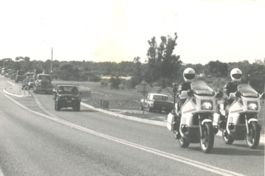
... Escorting the truck blockade Princes Highway East Gippsland Victoria. ...Lakes Entrance Historical Society 4 Marine Parade Lakes Entrance gippsland Escorting the truck blockade Princes Highway East Gippsland Victoria. protest Timber Industry Events Black and white photograph of two motor cycle police. ...Escorting the truck blockade Princes Highway East Gippsland Victoria. Black and white photograph of two motor cycle police. Also five black and white photographs taken during the timber truck convoy in East Gippsland protest, timber industry, events -
 Orbost & District Historical Society
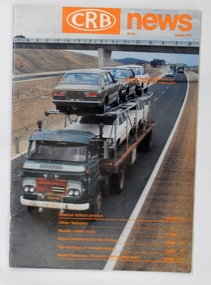
magazine, CRB News, August 1975
... It contains an article on the Princes Highway, Gippsland....It contains an article on the Princes Highway, Gippsland. CRB News magazine Country Roads Board ...The Country Roads Board was the government authority for the construction and maintenance of main roads in Victoria between 1913 and 1983. It was succeeded by the Road Construction authority on 1 July 1983 and later merged with the Road Traffic Authority on July 1 1989 to form the Roads Corporation. James Cameron, an Orbost farming pioneer and Member of the Legislative Assembly, fathered the Country Roads Board.This item is a useful research source on the Princes Highway, Gippsland.A 19 pp magazine, titled CRB ( Country Roads Board) News. It is dated August 1976. On the front cover is a coloured photograph of a truck carrying cars. In the background is a road bridge. It contains an article on the Princes Highway, Gippsland.magazine journal-crb-news princes-highway -
 Orbost & District Historical Society
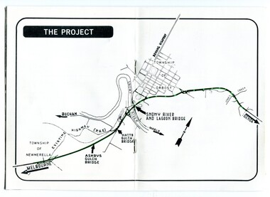
pamphlets, Princes Freeway - Orbost Section, 1976
... This construction was an important development along the Princes Highway corridor through East Gippsland. The original highway approached the Snowy River at a very poor alignment, and several serious accidents had occurred at the Orbost end. ... corridor through East Gippsland. The original highway approached the Snowy River at a very poor alignment, and several serious accidents had occurred at the Orbost end. ...Opened by the Hon. J A Rafferty, Minister for Transport, 25 November 1976, the bridge was the first of four bridges to be built as part of the freeway bypass of Orbost. Construction cost $2.4 million. This construction was an important development along the Princes Highway corridor through East Gippsland. The original highway approached the Snowy River at a very poor alignment, and several serious accidents had occurred at the Orbost end. In times of heavy flood, the highway on both sides of the river had been cut by floodwaters and during the 1971 floods, the highest ever recorded, the river was a mile wide at the crossing. Construction of the bridges commenced in January 1975, with an expectation to open the bridge across the Snowy River as soon as possible. Less than two years later, on 25 November 1976, the bridge across the Snowy River was opened to traffic, allowing the old bridge to be demolished. The remainder of the Orbost Bypass, both the floodplain crossings and the eastern section around the township itself, was declared ‘Princes Freeway’ and opened to traffic in December 1977. (ref http://mrv.ozroads.com.au) The Country Roads Board was the government authority for the construction and maintenance of main roads in Victoria between 1913 and 1983. It was succeeded by the Road Construction authority on 1 July 1983 and later merged with the Road Traffic Authority on July 1 1989 to form the Roads Corporation. James Cameron, an Orbost farming pioneer and Member of the Legislative Assembly, fathered the Country Roads Board. The opening of this Snowy River Bridge was an important development in the accessibility to the township of Orbost.Three coloured Country Roads pamphlets for the 'Princes Freeway - Orbost Section". On the front is a coloured photograph of the new construction over the Snowy River at Orbost. Inside is a program for a ceremony for the opening of the new Snowy River Bridge. There is also a black print map of the project. -
Ringwood and District Historical Society
Name List, A suggested list of names suitable for streets in Ringwood, and showing origin of name - compiled 1970, c.1970
... Active in Ringwood East Progress Association over 40 years ago.; "Barker's Track" - forerunner of Gippsland Road, Maroondah Highway.; Bickford, N Superintendent of Hodgkinson's Field Party of Surveyors etc. ...Active in Ringwood East Progress Association over 40 years ago.; "Barker's Track" - forerunner of Gippsland Road, Maroondah Highway.; Bickford, N Superintendent of Hodgkinson's Field Party of Surveyors etc. ...A suggested list of names suitable for streets in Ringwood, and showing origin of name. Two pages foolscap, 100 names approx. ; Hull: Surveyed Gippsland Road now Maroondah Highway, 1855 (Also name of roar in Croydon); Darke, Wm Wedge, Surveyed all land between Yarra and Western Port, including Ringwood - 1843; Wedge, Chas. Nephew of John Helder Wedge, Batman's surveyor, 1834. Active in Ringwood East Progress Association over 40 years ago.; "Barker's Track" - forerunner of Gippsland Road, Maroondah Highway.; Bickford, N Superintendent of Hodgkinson's Field Party of Surveyors etc. Original Land Owners; Isaacs,S. G. Bought first land in Ringwood - March 1858 - Lot 3; Moss, M.Lot 1 - April 1858; Davis, J. Lot 6 - April 1858; Riley, P. Lot 11 - April 1858; Marks, M.Lot 15 - November 1858; Wieland, C.F. Lot 14b - July 1872; Richter, K.H. Lot 14a - April 1869; Molloy, J. Lot 21 - December 1877; Watson, B. Lot 22a - April 1869; Stutt, W. Lot 27 - June 1884; Blood, R & W.Lot 42-3 - March 1872; Cox, J. Lot 41 - March 1870; Moncrieff, T.Lot 40a - September 1876; Pett, J. Lot 40b - January 1878; Feltham, F. Lot 28a - September 1881; Downing, J.J.Lot 32b - October 1881; Burge, W. Lot 39 - April 1875; Axford, W. Lot 32a - December 1877; Ball, E.A.Lot 37 - March 1869; Parker, G. Lot 28 - June 1882; Gangell, W.Lot 24a - January 1883; Hodgson, A.D. Lot 25a - May 1875; Muldowney, P. Lot 30d - June, 1877; Hosie, J.S. Lot 34, 30b - June 1878; Rourke, H.Lot 36 - July 1869; Duggan, T.Lot 35 - May 1870; Pach, W. Lot 30e - May 1884; Morris, J. Lot 25b - June 1882; Kleinert, A. Lot 29c - August 1886 +Additional Keywords: Hull / Darke, Wm Wedge / Wedge, Chas / Wedge, John Helder / Bickford, N -
 Orbost & District Historical Society
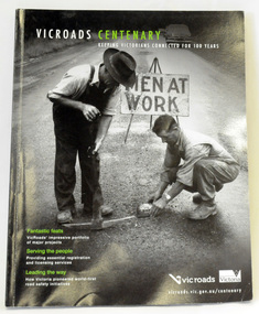
book, Vic Roads Centenary 1913 -2013, 2013
... Highway) at Orbost 1974-1976. This book is a useful reference tool on the history of road construction in Victoria including East Gippsland. vicroads book roads snowy-river-bridge jellie-david A thick, bound paperback book, titled "VicRoads Centenary Keeping Victorians Connected for 100 Years". ...The publication, VicRoads Centenary: Keeping Victorians Connected for 100 Years, looks at the people and projects that define VicRoads’ history. Written by current and former VicRoads’ employees, the publication details the organisation’s portfolio of major projects, which includes the Great Ocean Road, Hume Highway and Eastern Freeway. Other sections report on Victoria’s world-first road safety initiatives, VicRoads’ use of technology and sustainability measures. (ref VicRoads) This item is one of several books donated by David Jellie at a presentation to Orbost Historical Society. He was a contributor to the book and was the engineer for the Snowy River Bridge (Princes Highway) at Orbost 1974-1976.This book is a useful reference tool on the history of road construction in Victoria including East Gippsland.A thick, bound paperback book, titled "VicRoads Centenary Keeping Victorians Connected for 100 Years". On the front cover is a black/white photograph of two men working on a road. One has a pick. The book contains the history of VicRoads, photographs, maps and advertisements. Some are b/w. Others are coloured.vicroads book roads snowy-river-bridge jellie-david -
 Orbost & District Historical Society
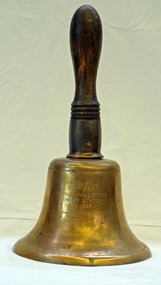
Functional object - Bell, hand-held, Early 20th century, c.1900s
... The settlement of Cabbage Tree Creek is located on the Princes Highway, 27 km east of Orbost in East Gippsland. The creek, which flows through undulating forest, takes its name from the patches of Cabbage Fan palms growing along its course. ...Orbost & District Historical Society Ruskin Street Orbost gippsland The settlement of Cabbage Tree Creek is located on the Princes Highway, 27 km east of Orbost in East Gippsland. ...The settlement of Cabbage Tree Creek is located on the Princes Highway, 27 km east of Orbost in East Gippsland. The creek, which flows through undulating forest, takes its name from the patches of Cabbage Fan palms growing along its course. A school commenced classes in 1913, but enrolment was small and at times the school operated part time with several other small schools in the area. The school building served as a hall for the district. About 1946 two sawmills commenced operations at Cabbage Tree Creek, and the Forests Commission ranger was stationed in the area. The increased population allowed the school to have more teachers and make improvements. In 1953, a new prefabricated building was erected on a new site. However, by the 1970s employment in the timber industry was unstable and the population decreased. By 1974 the school again had only one teacher and eventually closed in 1993 to amalgamate with the Orbost primary School in Ruskin Street, Orbost. (Ref. VictorianPlaces)The school bell is a signal that tells a school's students when it is time to go to class in the morning and when it is time to change classes during the day as well as when students are dismissed from school. In most schools today it will be a tone, siren, electronic bell sound, a series of chimes, or music played over an intercom but often still called "the school bell". This item reflects the history of Cabbage Tree Creek as well as the technological changes in the school system.Brass bell with incised double lines on bottom edge and top near handle, featuring descriptive notation on front face. Bell has long wooden handle shaped and incised with four lines at base before brass housing with singular screw holding handle in place. Object is showing signs of wear, with blackened handle and patches of green oxidisation.SCHOOL BELL / SS No 3812 / CABBAGE TREE CREEK / PRIMARY SCHOOL / 1913-1993 / FORMALLY INCORPORATED / INTO / ORBOST / PRIMARY SCHOOL / 1994cabbage tree, east gippsland, cabbage tree creek, cabbage tree creek primary school, orbost primary school, school bells -
 Orbost & District Historical Society
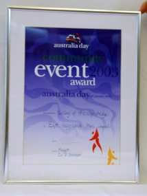
framed certificate, January 2003
... Gippsland Shire Council Australia Day celebrations on 26.1.2003. The veiling of McKillops bridge was a 'Year of the Outback' event. The event was organised by Orbost resident, Sr Helen Barnes RSJ. to show solidarity with rural people. The local community transformed the bridge into "a symbol of communal love and hope", when its sides were draped with hundreds of personal messages. McKillop's Bridge, located high in the Snowy Mountains, is named after George McKillop, a pioneering explorer of the area. The bridge is a vital link for isolated farming communities living beyond the Bonang highway...Gippsland Shire Council Australia Day celebrations on 26.1.2003. The veiling of McKillops bridge was a 'Year of the Outback' event. The event was organised by Orbost resident, Sr Helen Barnes RSJ. to show solidarity with rural people. The local community transformed the bridge into "a symbol of communal love and hope", when its sides were draped with hundreds of personal messages. McKillop's Bridge, located high in the Snowy Mountains, is named after George McKillop, a pioneering explorer of the area. The bridge is a vital link for isolated farming communities living beyond the Bonang highway ...This certificate was presented at the East Gippsland Shire Council Australia Day celebrations on 26.1.2003. The veiling of McKillops bridge was a 'Year of the Outback' event. The event was organised by Orbost resident, Sr Helen Barnes RSJ. to show solidarity with rural people. The local community transformed the bridge into "a symbol of communal love and hope", when its sides were draped with hundreds of personal messages. McKillop's Bridge, located high in the Snowy Mountains, is named after George McKillop, a pioneering explorer of the area. The bridge is a vital link for isolated farming communities living beyond the Bonang highway. The Veiling of McKillops Bridge was a significant community event.A large framed certificate. An Australia Day Community Event certificate for January 2003. The frame is silver The certificate has white, green and blue print on a blue background.presented to "Veiling of McKillops Bridge on frame corner AMS by East Gippsland Shie Council signed by Cr P. Bommer (mayor)mckillops-bridge-veiling east-gippsland-shire-council-australia-day -
 Orbost & District Historical Society
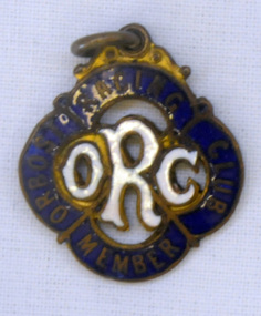
badge, 1890's
... gippsland This is a member's badge for the Orbost Racing Club and belonged to Mat Lynch. Secretary was Mr W. A. Malcolm. Some of the earliest horse races were held on a course in a paddock belonging to Mr James Cowell at Jarrahmond. For a long time horse races were part of the Marlo Picnic Races. Bellagoogan on Majors Creek near Orbost was the site of the first race course. Mat Lynch was a prominent local identity and generously donated a block of land situated on the Princes Highway ...This is a member's badge for the Orbost Racing Club and belonged to Mat Lynch. Secretary was Mr W. A. Malcolm. Some of the earliest horse races were held on a course in a paddock belonging to Mr James Cowell at Jarrahmond. For a long time horse races were part of the Marlo Picnic Races. Bellagoogan on Majors Creek near Orbost was the site of the first race course. Mat Lynch was a prominent local identity and generously donated a block of land situated on the Princes Highway, for the Brodribb Hall.Horse racing played a vital role in the history of Orbost. This item is connected to that role.A small metal badge which is a diamond shape with rounded corners. It has a small metal loop at the top. In gold print is "Member Orbost Racing Club" on a dark blue enamel around the edge. In the centre is "ORC" in white enamel.On back - 28 - LYNCH - almost indecipherable.orbost-racing-club lynch-mat recreation horse-racing -
 Orbost & District Historical Society
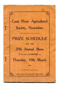
program, Snowy River Mail, 1927
... Cann River is a town in the East Gippsland region of Victoria in Australia. The town is located on the Cann River at the junction of the Princess Highway and the Monaro Highway, in the Shire of East Gippsland. ...Orbost & District Historical Society Ruskin Street Orbost gippsland Cann River is a town in the East Gippsland region of Victoria in Australia. The town is located on the Cann River at the junction of the Princess Highway and the Monaro Highway, in the Shire of East Gippsland. ...Cann River is a town in the East Gippsland region of Victoria in Australia. The town is located on the Cann River at the junction of the Princess Highway and the Monaro Highway, in the Shire of East Gippsland. Before 1929 the original Cann River settlement was where Noorinbee now stands.Agricultural shows are an important part of cultural life in small country towns and these shows form an integral part of local history. This item reflects the significance of a volunteer group which no longer exists.A stapled paper program, orange with black print,"Cann River Agricultural Society, Noorinbee Prize Schedule for the 20th Annual Show to be held at Noorinbee on Thursday 10th March 1927" inside a rectangular black frame. -
 Orbost & District Historical Society
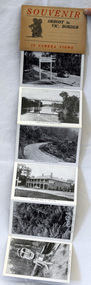
post cards, ca. 1945
... Orbost & District Historical Society Ruskin Street Orbost gippsland This is a souvenir of Orbost from 1945. postcard souvenir photographs Orbost Cann-River SOUVENIR Orbost to Vic Border 13 camera views A set of 13 black and white postcards in a fold-out format. Pictures are of : Nicholson Street, Snowy Rriver flats from Grand View, avenue leading to Obost. Snowy River bridge at Orbost, Snowy River at Orbost, Marlo from the sand dunes, Prince's Highway ...This is a souvenir of Orbost from 1945.A set of 13 black and white postcards in a fold-out format. Pictures are of : Nicholson Street, Snowy Rriver flats from Grand View, avenue leading to Obost. Snowy River bridge at Orbost, Snowy River at Orbost, Marlo from the sand dunes, Prince's Highway at Victorian-NSW. border, Genoa River and bridge at Genoa, Prince's Highway at Mt. Drummer, Cann River hotel, fern scene, Euchre Valley, ponsasinorum near Cann River. SOUVENIR Orbost to Vic Border 13 camera viewspostcard souvenir photographs orbost cann-river -
 Orbost & District Historical Society
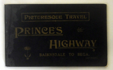
book, Vogt, H, Picturesque Travel Prince Highway, C 1921
... gippsland Possibly owned by A. C. Nixon. This book was donated by Peter Nixon. travel Prince's-Highway car-touring inside - Presented to Orbost Historical Society by Peter Nixon, Chief Commissioner, Shire 1/2/97. ...Possibly owned by A. C. Nixon. This book was donated by Peter Nixon.A small 139 pp book with a black /dark brown cover and gold lettering. It is titled Picturesque Travel Prince's Highway Bairnsdale to Bega. The back cover is green.inside - Presented to Orbost Historical Society by Peter Nixon, Chief Commissioner, Shire 1/2/97.travel prince's-highway car-touring -
 Orbost & District Historical Society
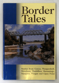
book, Border Tales, 2000
... Gippsland, Victoria. It is close to the New South Wales border where the Princes Highway crosses the Genoa River....Gippsland, Victoria. It is close to the New South Wales border where the Princes Highway crosses the Genoa River. ...The book was compiled by Peter Allard and Geoff Alves and published by the Genoa Town Committee. Genoa is a small town in East Gippsland, Victoria. It is close to the New South Wales border where the Princes Highway crosses the Genoa River.A paperback book of 120pp titled Border tales : stories from Genoa, Wangarabell, Wroxham, Timbillica, Maramingo, Nungatta, Wingan and Gipsy Point. On the front cover is a coloured picture of the bridge across the Genoa river at Genoa. -
 Orbost & District Historical Society
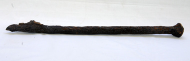
bridge spike
... gippsland This spike came from the old Brodribb River bridge which is about 9.6 kilometres from Orbost. The Brodribb River joins the Snowy River north of Marlo. In 1906, a bridge replaced the punt over the Brodribb River, improving communication with Orbost. It was eventually replaced by a reinforced concrete bridge built by the Road Construction Authority in 1989 where the Princes Highway ...This spike came from the old Brodribb River bridge which is about 9.6 kilometres from Orbost. The Brodribb River joins the Snowy River north of Marlo. In 1906, a bridge replaced the punt over the Brodribb River, improving communication with Orbost. It was eventually replaced by a reinforced concrete bridge built by the Road Construction Authority in 1989 where the Princes Highway passes over the Brodribb RiverThis item belongs to a significant local structure which has been replaced.A very rusty iron bridge spike from the old Brodribb Bridge.brodribb-river bridge-spike -
Port Melbourne Historical & Preservation Society
Photograph - Shipping using Webb Dock, Williamstown and various River Yarra berths, Ron Laing, 1986 - 1999
... highway...anro australia...toyofuji 8...columbus america...union rotoma...searoad tamar...antwerpen...contship jork...queensland star...kha bhum...columbus new zealand...city of port melbourne...dock express ii...direct kea...samas spirit...arafura...contship action...searoad mersey...ville de capella...australia bridge...juthia bhum...direct eagle...columbia star...torrons...hakuyou maru...berlin express...tourcoing...rabelis...bass trader...zim brisbane...australian advance...sea venus...morning light...matilda bay...ooclexporter...qiutte...lloydiana...direct kookaburra...nichigon maru...era...golden crux ii...canopus...stolt sincerity...ionikos...iron gippsland...Port Melbourne Historical & Preservation Society Port Melbourne Town Hall 333 Bay Street Port Melbourne melbourne mairangi bay columbus australia michigan highway anro australia toyofuji 8 columbus america union rotoma searoad tamar antwerpen contship jork queensland star kha bhum columbus new zealand city of port melbourne dock express ii direct kea samas spirit arafura contship action searoad mersey ville de capella australia bridge juthia bhum direct eagle columbia star torrons hakuyou maru berlin express tourcoing rabelis bass trader zim brisbane australian advance sea venus morning light matilda bay ooclexporter qiutte lloydiana direct kookaburra nichigon maru era golden crux ii canopus stolt sincerity ionikos iron gippsland ehjin satucket irene paum monarch torbon spirit cgm la perouse amvella Transport - Shipping Piers and Wharves Ron LAING Eclipse A set of 83 photographs of shipping using Webb Dock, Williamstown, various river berths and movements in the Yarra River 1986-1999 Photograph Shipping using Webb Dock, Williamstown and various River Yarra berths Ron Laing ...A set of 83 photographs of shipping using Webb Dock, Williamstown, various river berths and movements in the Yarra River 1986-1999mairangi bay, columbus australia, michigan highway, anro australia, toyofuji 8, columbus america, union rotoma, searoad tamar, antwerpen, contship jork, queensland star, kha bhum, columbus new zealand, city of port melbourne, dock express ii, direct kea, samas spirit, arafura, contship action, searoad mersey, ville de capella, australia bridge, juthia bhum, direct eagle, columbia star, torrons, hakuyou maru, berlin express, tourcoing, rabelis, bass trader, zim brisbane, australian advance, sea venus, morning light, matilda bay, ooclexporter, qiutte, lloydiana, direct kookaburra, nichigon maru, era, golden crux ii, canopus, stolt sincerity, ionikos, iron gippsland, ehjin, satucket, irene, paum monarch, torbon spirit, cgm, la perouse, amvella, transport - shipping, piers and wharves, ron laing, eclipse -
 Ringwood and District Historical Society
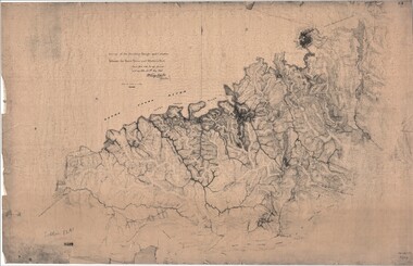
Map, Survey of Dividing Range between Yarra Yarra and Western Port - William Wedge Darke, 1843
... This road was for many years the major route to Gippsland and to the higher country about Alexandra and Mansfield, sometimes known as White Horse Road, and now Maroondah Highway....This road was for many years the major route to Gippsland and to the higher country about Alexandra and Mansfield, sometimes known as White Horse Road, and now Maroondah Highway. ...Extract - Ringwood, Place of Many Eagles - Hugh Anderson (1974): William Wedge Darke, from Hereford, England, was a nephew of John Helder Wedge of the Port Phillip Association, who was also a surveyor. William's most important work was probably his survey of the Dividing Range and the country between the Yarra River and Western Port, completed in May 1843, and during which he made a traverse between the Mullum and Dandenong creeks along the higher ground that he labelled the "best line of road from Melbourne". This road was for many years the major route to Gippsland and to the higher country about Alexandra and Mansfield, sometimes known as White Horse Road, and now Maroondah Highway.Surveyor's relief map of features to the east of Melbourne including Yarra Yarra River, Mullum Mullum Creek, Anderson's Creek, Dandenong Creek.Transmitted to the Surveyor General with my letter of 10th May 1843 (signed) Wm Wedge Drake, Assistant Surveyor. Scale: two inches to a mile. Descriptive remarks include upstream area of Yarra River - "impassable, appears to have been formerly a lake", and to the south - "barren and scrubby swamps of the Western Port Country". Marked tracks include "best line of road from Melbourne", "track to Dandenong", "Road to Port Albert may probably be found on this range", "Best line to Upper Yarra". Several huts also marked. -
 Australian National Surfing Museum
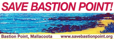
Sticker, SAVE BASTION POINT, Circa 2010
... Australian National Surfing Museum 77 Beach Road Surf City Plaza Surfcoast Highway Torquay great-ocean-road This colour sticker was produced and distributed Australia wide by the SAVE BASTION POINT CAMPAIGN to support their environmental campaign to stop a breakwall being built across the popular surf break - Bastion Point in Mallacoota, Victoria, Australia. The breakwall is supported by the local fishing community and local council. If built it would destroy one of the most popular surf breaks in East Gippsland ...This colour sticker was produced and distributed Australia wide by the SAVE BASTION POINT CAMPAIGN to support their environmental campaign to stop a breakwall being built across the popular surf break - Bastion Point in Mallacoota, Victoria, Australia. The breakwall is supported by the local fishing community and local council. If built it would destroy one of the most popular surf breaks in East Gippsland.This sticker represents a local environmental campaign which has gained state and national attention. Full colour gloss car sticker featuring graphic artwork of Bastion Point and the website for the SAVE BASTION POINT campaign (based in Mallacoota, Victoria, Australia)Web address - www.savebastionpoint.orgsurf, bastion point, mallacoota, breakwall, surfrider foundation, east gippsland, save bastion point -
 City of Moorabbin Historical Society (Operating the Box Cottage Museum)
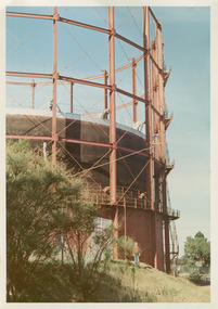
Photographs, x3 Colour,, Highett Gasworks c1974, 1974
... Highway, began supply 1939. 1950 an extension program was completed. However by 1965 , with the discovery of Natural Gas offshore in Bass Strait, changes to Gas distribution were apparent. At first some of the facilities at Highett were used to distribute the gas piped from Sale, Gippsland...Highway, began supply 1939. 1950 an extension program was completed. However by 1965 , with the discovery of Natural Gas offshore in Bass Strait, changes to Gas distribution were apparent. At first some of the facilities at Highett were used to distribute the gas piped from Sale, Gippsland ...3 of 5 photographs of the Highett Gasworks c 1974 The Brighton Gas Company was established 1877 by local residents including Thomas Bent. Initially all went well for residents as gas light replaced kerosene lamps and street lights were installed. However disruption to supply, poor quality and failure to reach all house lead to dissatisfaction. Thomas Bent therefore began the Central Brighton and Moorabbin Gas Company 1885 and a price war ensued. This was unsustainable and the two companies amalgamated in 1877 supplying gas from the New Street Works site. 1930 this Company expanded to Highett where it had purchased 45 acres adjacent to the train line. 1927 a gas holder was built connected to the Brighton works 1936 construction began on a complete gas-making unit and the Highett Gasworks, Nepean Highway, began supply 1939. 1950 an extension program was completed. However by 1965 , with the discovery of Natural Gas offshore in Bass Strait, changes to Gas distribution were apparent. At first some of the facilities at Highett were used to distribute the gas piped from Sale, Gippsland. However after conversion of 450,000 homes to Natural Gas the Highett site was redundant. The gasometers were removed 1978. Moorabbin Council obtained part of the land for public recreation purposes. ( Dr. G Whitehead KCC Historian ) c2012 the Moorabbin Justice Centre / Magistrates Court of Victoria was built and further development of the area for apartments proceeds. The establishment of the Brighton Gas Company 1877 and the Highett Gasworks 1885 brought bright lighting to houses, businesses and streets in Moorabbin Shire and cooking ovens and heating improved the living conditions of residents. 3 x Colour photographs of the Highett Gasworks c1970bass strait gas, highett gasworks, brighton gasworks 1877, central brighton and moorabbin gas company 1885, whitehead dr. graham, magistrates court of victoria, horse drawn carts, toll gates brighton, motor cars 1900, steam engines, early settlers, bentleigh, parish of moorabbin, city of moorabbin, county of bourke, moorabbin roads board, shire of moorabbin, henry dendy's special survey 1841, were j.b.; bent thomas, o'shannassy john, king richard, charman stephen, highett william, ormond francis, maynard dennis, market gardeners, vineyards, orchards -
 Orbost & District Historical Society
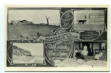
black and white postcard, C1910
... Orbost & District Historical Society Ruskin Street Orbost gippsland This an advertisement / souvenir for Merrangbaur House in Lakes Entrance. Merrangbaur was in , Lakes Entrance and stood on the on the Prince's Highway, about a kilometre from Lakes Entrance. ...This an advertisement / souvenir for Merrangbaur House in Lakes Entrance. Merrangbaur was in , Lakes Entrance and stood on the on the Prince's Highway, about a kilometre from Lakes Entrance. It was destroyed by fire on the early morning of December 15, 1935. The original residence of the Roadknight family, the first white settlers in the Lakes Entrance district, Merrangbaur House had been conducted as a guest house for many years. Much of the furniture was lost, although a portion of the building, consisting of the ballroom and several bedrooms, was saved Mrs. Anne McInnes, aged more than 80 years, the mother of the proprietress, Miss McInnes, was the only guest sleeping in the house when the fire began and had to be assisted from her blazing bedroom on the ground floor. She was carried through a window by members of the fire brigade and spent the remainder of the night at the house of a friend. Miss McInnes was in Melbourne on a business visit arranging for Christmas bookings, when she was informed of her loss. (info. from The Argus Melbourne Monday December 16 1935)This item is associated with tourism in East Gippsland in the early 20th century.A black / white photograph / postcard.There is a photograph of a Lakes Entrance scene in each corner with a banner for "ROADKNIGHT'S MERRANGBAUR HOUSE' in the middle.In a circle is "FIRST CLASS ACCOMMODATION TARIFF 30/- WEEKLY". It has a note that "Coaches for Buchan Caves call at Merrangbaur daily".merrangbaur-lakes-entrance roadknight-lakes-entrance postcard-lakes-entrance -
 Orbost & District Historical Society
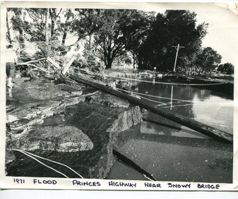
black and white photograph, February 1971
... Orbost & District Historical Society Ruskin Street Orbost gippsland This photograph was taken near the Snowy River Bridge on the the old Princes Highway in Orbost, near the caravan park. ...This photograph was taken near the Snowy River Bridge on the the old Princes Highway in Orbost, near the caravan park. The 1971 flood was the the worst flood on record. At Jarrahmond it was at least 11 metres and up to one and a half kilometres wide on the flats causing enormous damage to the flood plain. Records say that "The brown floodwater stain in Bass Strait could be seen from passing airliners." Considerable damage was done to railway infrastructure, roads and farms. More information from the APRIL, 2008 newsletter by John Phillips. (see orbosthistory.com.au)This is pictorial evidence of a significant local event. Floods have been an integral part of Orbost's history for hundreds of years.A black / white photograph of debris, fallen power lines, a tree across the highway and floodwaters across the road.on front at bottom - handwritten in upper case print - " 1971 FLOOD PRINCES HIGHWAY NEAR SNOWY BRIDGE"floods-orbost-1971 -
 Orbost & District Historical Society
black and white photograph, early 20th century
... gippsland The hotel at Bonang was also known as Clancy's Hotel, Bonang, after its licensee, William Clancy. It operated from the late 1890s until early 20th century. William Clancy was aslo the postmaster at Bonang. A post office operated at Bonang from at least 1859. At the time Bonang was "a small, scattered collection of buildings marking the intersection of the Bonang Highway ...The hotel at Bonang was also known as Clancy's Hotel, Bonang, after its licensee, William Clancy. It operated from the late 1890s until early 20th century. William Clancy was aslo the postmaster at Bonang. A post office operated at Bonang from at least 1859. At the time Bonang was "a small, scattered collection of buildings marking the intersection of the Bonang Highway and the McKillops Bridge Road" ( from Regional Heritage Assessment 1996). As the mining activity declined the township became even smaller as many of the population moved to Orbost,, a larger settlement. This is a pictorial record of Bonang, a small settlement approximately 50 km north of Orbost. The buildings in the photograph no longer exist.A black / white photograph mounted on grey card. there are stains from water damage on the mount. It is a photograph of two single-storeyed timber buildings fronting a wide dirt road. On the right is the Bonang Hotel with four men in suits standing on a verandah. The building on the right is the Bonang Post Office and there are three men outside it. the photograph has been posed. on back - 'Grandma Clancy owned the hotel & Uncle Will had a gold mine which he worked"bonang bonang-post-office bonang-hotel clancy-william clancy's-hotel-bonang -
 Orbost & District Historical Society
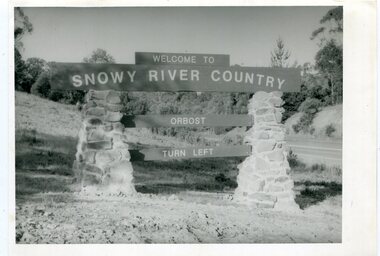
black and white photographs, second half 20th century
... 3277.1 on back - "WELCOME TO SNOWY RIVER COUNTRY - ORBOST sign - Princes Highway - Newmerella" 3277.2 on back - "East Gippsland Shire Sign on eastern approach to ORBOST., in Salisbury Street, near Orbost Secondary College" 3277.3 on back - "Tree planting in Salisbury St, Orbost in front of Orbost High School looking west towards Orbost township"...Orbost & District Historical Society Ruskin Street Orbost gippsland These photographs are pictorial records of the signs at the Orbost town entry points. photographs-Orbost Orbost-township-entry Salisbury-Street-trees town-entry road-signs-Orbost 3277.1 on back - "WELCOME TO SNOWY RIVER COUNTRY - ORBOST sign - Princes Highway - Newmerella" 3277.2 on back - "East Gippsland Shire Sign on eastern approach to ORBOST., in Salisbury Street, near Orbost Secondary College" 3277.3 on back - "Tree planting in Salisbury St, Orbost in front of Orbost High School looking west towards Orbost township" Three black / white photographs. 3277.1 is a sign on stone pillars at the top of a hill - "WELCOME TO SNOWY RIVER COUNTRY ORBOST TURN LEFT". 3277.2 shows a road leading into a town. ...These photographs are pictorial records of the signs at the Orbost town entry points.Three black / white photographs. 3277.1 is a sign on stone pillars at the top of a hill - "WELCOME TO SNOWY RIVER COUNTRY ORBOST TURN LEFT". 3277.2 shows a road leading into a town. There is a sign on the left - "ORBOST" and a service station on the right. 3277.3 shows a row of newly planted trees between a road and a school.3277.1 on back - "WELCOME TO SNOWY RIVER COUNTRY - ORBOST sign - Princes Highway - Newmerella" 3277.2 on back - "East Gippsland Shire Sign on eastern approach to ORBOST., in Salisbury Street, near Orbost Secondary College" 3277.3 on back - "Tree planting in Salisbury St, Orbost in front of Orbost High School looking west towards Orbost township"photographs-orbost orbost-township-entry salisbury-street-trees town-entry road-signs-orbost -
 Orbost & District Historical Society
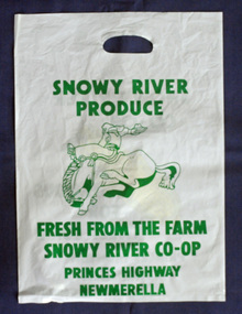
Container - Plastic bag/container, plastic bag SNOWY RIVER CO-OP
... gippsland A plastic produce bag from c.1990s used for promotion of the SNOWY RIVER PRODUCE Co. which was famous as a sweet corn producer. The sweet corn was grown locally under contract by farmers in the Orbost district and marketed through the Co. This company no-longer exists (2022). a rare item to survive as evidence of the Snowy River Produce Co Orbost sweet corn farming produce snowy river produce co. Side 1: SNOWY RIVER PRODUCE. FRESH FROM THE FARM SNOWY RIVER CO-OP PRINCES HIGHWAY ...A plastic produce bag from c.1990s used for promotion of the SNOWY RIVER PRODUCE Co. which was famous as a sweet corn producer. The sweet corn was grown locally under contract by farmers in the Orbost district and marketed through the Co. This company no-longer exists (2022).a rare item to survive as evidence of the Snowy River Produce CoA white plastic bag, printed on both sides with green print. One side has a drawing of a bucking horse and rider, and the other side a piece of yellow coloured corn. The bag has a hand hold opening. Size of bag: H-504mm W-362mmSide 1: SNOWY RIVER PRODUCE. FRESH FROM THE FARM SNOWY RIVER CO-OP PRINCES HIGHWAY MEWMERELLA Side 2: SNOWY RIVER CO-OP FAMOUS FOR SWEET CORN PRINCES HIGHWAY NEWMERELLA phone (051) 541878orbost, sweet corn, farming produce, snowy river produce co. -
 Orbost & District Historical Society
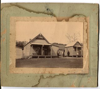
black and white photograph, late 19th century - early 20th century
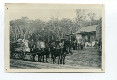
... The settlement of Cabbage Tree Creek is located on the Princes Highway, 27 km east of Orbost in East Gippsland. The first white settler arrived in the valley in 1887 cutting a dray track from Marlo to the south-west. ...Orbost & District Historical Society Ruskin Street Orbost gippsland This is a photograph of Alice Swallow's hotel at Cabbage Tree. The settlement of Cabbage Tree Creek is located on the Princes Highway, 27 km east of Orbost in East Gippsland. ...This is a photograph of Alice Swallow's hotel at Cabbage Tree. The settlement of Cabbage Tree Creek is located on the Princes Highway, 27 km east of Orbost in East Gippsland. The first white settler arrived in the valley in 1887 cutting a dray track from Marlo to the south-west. Several families cleared the alluvial flats, growing maize, peas and beans and raising pigs, cattle and sheep. Later the farmers milked cows, sending cream to Orbost. In the late 1890s, small quantities of alluvial gold were found in the creek. A school commenced classes in 1913, but enrolment was small and at times the school operated part time with several other small schools in the area. The school building served as a hall for the district. From the 1920s the Cabbage Tree Hotel catered to drivers on the improved Princes Highway. (info. from Victorian Places)This is a pictorial record of Cabbage Tree, East Gippsland in the late 20th century. It shows a building that no longer exists.A black / white photograph of a small, single - storey wooden building in a bush setting. There are people standing in front of the building with a horse and wagon nearby. In the foreground is a wagon with four horses hitched to it and the driver seated behind the horses. -
 Orbost & District Historical Society
black and white photograph, 1924
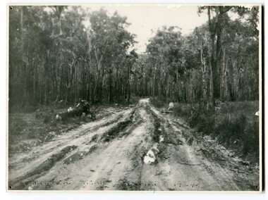
... This photograph shows the main road near Bellbird, East Gippsland, in 1924. This road would have been the Princes Highway, a main thoroughfare through to New South Wales. ...Dairy farming still plays an essential role in the township. this is a pictorial record of the Princes Highway, the main road from East Gippsland to the New South Wales border. road Princes-Highway Bellbird-Creek-1924 on front - "Main Rd near Bellbird 1924" A large black / white photograph of a very wet and boggy bush road. black and white photograph ...This photograph shows the main road near Bellbird, East Gippsland, in 1924. This road would have been the Princes Highway, a main thoroughfare through to New South Wales. Bellbird Creek is a small rural location between Orbost and Cann River. There was no township at Cabbage Tree at this time. The Cabbage Tree Creek township was established to support the booming timber industry of the mid 20th century. Five timber mills worked full time supporting the families that were drawn to the area's wealth of natural resources. Nestled on the banks of the Cabbage Tree Creek, the township was built by those mills to house their workers. Today although the timber mills have disappeared, some of the buildings still remain. Little now remains to remind of the saw-milling history apart from photographs and some relics - a boiler and a brick furnace. There was also a thriving agricultural community farming dairy, beef, seed beans and fresh peas and beans that were sent to the Victoria Market in Melbourne. Dairy farming still plays an essential role in the township. this is a pictorial record of the Princes Highway, the main road from East Gippsland to the New South Wales border.A large black / white photograph of a very wet and boggy bush road.on front - "Main Rd near Bellbird 1924"road princes-highway bellbird-creek-1924 -
 Orbost & District Historical Society
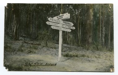
black and white photograph, first half 20th century
... Princes-Highway-East-Gippsland road-transport road-sign...Princes-Highway-East-Gippsland road-transport road-sign on front - Vic - NSW Border A black / white photograph postcard of the signpost at the Victorian - New South Wales border. ...Prior to the sealing of the Princes Highway west of Orbost, the road surface was anything but good, even by C1917 when cars started to use the road. From Orbost the old road via Marlo to Sydenham was abandoned for the new location which traversed more rugged country via Cabbage Tree, Bell Bird and Club Terrace to Cann River, and the reason for this diversion was on account of settlements being established at Murrungowar and Club Terrace, at which latter place there was a temporary rush to obtain gold. This road was constructed by the Public Works department and a maximum grade of 1 in 19 was adopted, and as speed was not to be catered for the grade followed in and out round the spurs and gullies, resulting in a maze of turns and twists which required a good deal of skill on the part of the horse driver to negotiate." - Bairnsdale Advertiser, Friday, May 2, 1947. (More information from Newsletter February 2010)This is a pictorial record of an early road distance sign on a major highway through East Gippsland. The distances are indicated in miles, a measurement standard no longer in use.A black / white photograph postcard of the signpost at the Victorian - New South Wales border. It shows distances to Sydney and Eden on one arrow and distances to Melbourne and Genoa on another. on front - Vic - NSW Borderprinces-highway-east-gippsland road-transport road-sign