Showing 210 items matching "hopkins road"
-
 Bendigo Historical Society Inc.
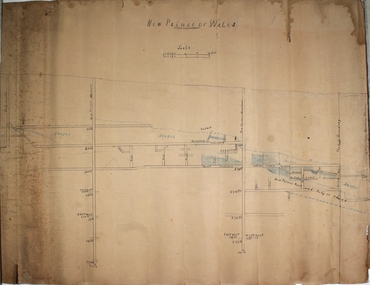
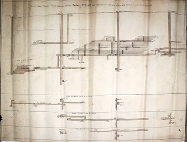
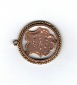
Plan - New Prince of Wales Mine
... ...Hopkins Road...The New Prince of Wales Mine was located Eaglehawk, nearest intersection Hopkins Road and Williams Road. The Old Prince of Wales Mine was nearby. ...Bendigo Margaret Roberts gold Shamrock Mine shaft New Prince of Wales Hopkins Road Williams Road Eaglehawk Hand drawn plan of Prince of Wales Mine, showing shaft and levels. ...The New Prince of Wales Mine was located Eaglehawk, nearest intersection Hopkins Road and Williams Road. The Old Prince of Wales Mine was nearby. Hand drawn plan of Prince of Wales Mine, showing shaft and levels. Written on top of plan: 'New Prince of Wales', with scale drawn underneath text. Plan forms part of the Margaret Roberts Collection of mining records. bendigo, margaret roberts, gold, shamrock mine, shaft, new prince of wales, hopkins road, williams road, eaglehawk -
 Warrnambool and District Historical Society Inc.
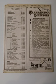
Pamphlet - Warrnambool Directories, Warrnambool City Council (Warrnambool Tourist Information Centre), Warrnambool Directory. Welcome to Warrnambool, Warrnambool and District Directory, 1970s and 80s
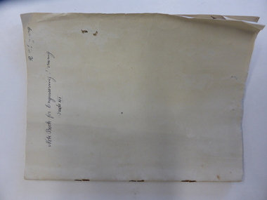
... Henry Flat 14 'Lyndoch' Hopkins Road Warrnambool Vic. 3280...Henry Flat 14 'Lyndoch' Hopkins Road Warrnambool Vic. 3280 .1 and .2 One sheet of paper folded twice to provide six pages. ...Warrnambool Directories.1 and .2 One sheet of paper folded twice to provide six pages. The pages contain a map and printed material. .3 One sheet pf paper folded to provide sixteen pages. The pages contain two maps and printed material. The front page has a stamp indicating the original owner. non-fictionWarrnambool Directorieswarrnambool tourism, shipwreck coast tourism -
 Bendigo Historical Society Inc.
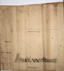
Plan - Prince of Wales No. 2 shaft
... Road...Hopkins Avenue...Princ e of Wales No. 2 shaft was located approx.130 metres west of the corner of Williams Road and Hopkins Avenue, Eaglehawk. ...Princ e of Wales No. 2 shaft was located approx.130 metres west of the corner of Williams Road and Hopkins Avenue, Eaglehawk. Margaret Roberts gold gold mine Bendigo Prince of Wales No. 2 Gold Mine Williams Road Hopkins Avenue Drawn on paper, plan shows cross section of mine workings. ...Princ e of Wales No. 2 shaft was located approx.130 metres west of the corner of Williams Road and Hopkins Avenue, Eaglehawk. Drawn on paper, plan shows cross section of mine workings. Written in pencil on top of plan 'Prince of Wales No. 2'. Plan forms part of the Margaret Roberts Collection of mining records. margaret roberts, gold, gold mine, bendigo, prince of wales no. 2 gold mine, williams road, hopkins avenue -
 Bendigo Historical Society Inc.
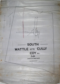
Map - South Wattle Gully Mine Chewton
... The New Prince of Wales Mine was located Eaglehawk, nearest intersection Hopkins Road and Williams Road. The Old Prince of Wales Mine was nearby. ...The New Prince of Wales Mine was located Eaglehawk, nearest intersection Hopkins Road and Williams Road. The Old Prince of Wales Mine was nearby. ...The New Prince of Wales Mine was located Eaglehawk, nearest intersection Hopkins Road and Williams Road. The Old Prince of Wales Mine was nearby. Hand drawn map of South Wattle Gully lease with mine working indicated on map. Written on map: 'Places and reports, South Wattle Gully, W. Edwards, July 1945' Plan forms part of the Margaret Roberts Collection of mining records. margaret roberts, gold, south wattle gully, chewton, lease holding -
 Bendigo Historical Society Inc.
Plan - New Prince of Wales Mine
... No 11, No. 1 and Old Prince of Wales workings' Mine location, nearest intersection, Williams Road and Hopkins Avenue, Eaglehawk. Plan forms part of the Margaret Roberts Collection of mining records. ...No 11, No. 1 and Old Prince of Wales workings' Mine location, nearest intersection, Williams Road and Hopkins Avenue, Eaglehawk. Plan forms part of the Margaret Roberts Collection of mining records. ...New Prince of Wales transverse section showing levels and shafts. Written on top of plan: 'New Prince of Wales workings shewing (railway. No 11, No. 1 and Old Prince of Wales workings' Mine location, nearest intersection, Williams Road and Hopkins Avenue, Eaglehawk. Plan forms part of the Margaret Roberts Collection of mining records. bendigo, margaret roberts, gold, shaft, longitudinal section, new prince of wales, eaglehawk -
 Warrnambool and District Historical Society Inc.
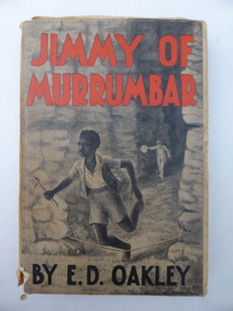
Book, Jimmy of Murrumbar by E D Oakley, 1938
... He was the fourth child of Thomas and Eliza Oakley who had the farm, Oakbank, near the mouth of the Hopkins River, Warrnambool (Otway Road area today). Edward Oakley first worked at Saltau’s shipping office in Warrnambool then ran a dairy farm, Halifax, near Cudgee. ...Warrnambool and District Historical Society Inc. 2 Gilles Street (south of Merri St) Warrnambool great-ocean-road This book subtitled, ‘A Story of the Amazing Ability and Fidelity of an Australian Black Tracker’, has been written in the late 1930s by Edward Daniel Oakley (1877-1962). He was the fourth child of Thomas and Eliza Oakley who had the farm, Oakbank, near the mouth of the Hopkins River, Warrnambool (Otway Road area today). ...This book subtitled, ‘A Story of the Amazing Ability and Fidelity of an Australian Black Tracker’, has been written in the late 1930s by Edward Daniel Oakley (1877-1962). He was the fourth child of Thomas and Eliza Oakley who had the farm, Oakbank, near the mouth of the Hopkins River, Warrnambool (Otway Road area today). Edward Oakley first worked at Saltau’s shipping office in Warrnambool then ran a dairy farm, Halifax, near Cudgee. He later had wheat farms in the Grampians area and at Willaura before returning to Warrnambool in 1923. He built a row of shops in Liebig Street and opened a boot and shoe store. He was instrumental in persuading Fletcher Jones to open a shop in Warrnambool. After he retired he researched and wrote the story of Jimmy of Murrumbar. This book is of high significance because: 1. It was written by a local Warrnambool businessman, Edward Oakley. He and other members of his family were prominent residents of the city in the late 19th and early to mid 20th centuries 2. It was written in the late 1930s and tells of the story of a young aboriginal boy, one of the early writings appreciating the talents and worth of young aborigines. This is a hard cover book of 181 pages. A buff-coloured dust cover has been pasted over the hard cover and it has a black, grey and white illustration of a young aboriginal boy being chased. This illustration is repeated in black and white on the second page. The titling on the cover is in red and black printing. The front cover has become almost detached from the pages. An inscription on the inside cover is handwritten in black ink. The book has a foreword, an appreciation, a contents page and 23 chapters. ‘Best Wishes for a Happy Birthday from Graeme Dorman Dec 8th 1942’ edward oakley, history of warrnambool, aboriginal literature, jimmy of murrumbar, thomas and eliza oakley -
 Warrnambool and District Historical Society Inc.
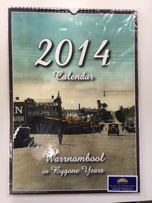
Calendar, Warrnambool in Bygone Years, 2013
... Warrnambool and District Historical Society Inc. 2 Gilles Street (south of Merri St) Warrnambool great-ocean-road This 2014 calendar was produced in Warrnambool and features reproductions of photographs of Warrnambool in past times. The photographs include the Botanic Gardens, the Breakwater, the War Memorial, Proudfoots Boatsheds, Liebig Street, the old Information Pavilion and the Hopkins River near the mouth. ...This 2014 calendar was produced in Warrnambool and features reproductions of photographs of Warrnambool in past times. The photographs include the Botanic Gardens, the Breakwater, the War Memorial, Proudfoots Boatsheds, Liebig Street, the old Information Pavilion and the Hopkins River near the mouth. The photographs in the calendar come from the collection of the Warrnambool and District Historical Society and were reproduced with the permission of the Society. This calendar is of minor importance but it does demonstrate the popularity of locally-produced yearly calendars and the interest in photographs of times gone. This is a 2014 calendar featuring twelve photographs of Warrnambool in past times. The photographs have been coloured or tinted and the front cover has a copy of the photograph featured for the month of March. The front cover has a brown edging and the inside front cover and the black cover are white. The dates are printed in two colours and vary from month to month. The paper is glossy and the pages have been bound with plastic spiral binding with a tab at the top to append the calendar to a wall. ‘2014 Calendar’ ‘Warrnambool in Bygone Years’ warrnambool photographs of the past, calendar 2014, spectrum print solutions -
 Warrnambool and District Historical Society Inc.
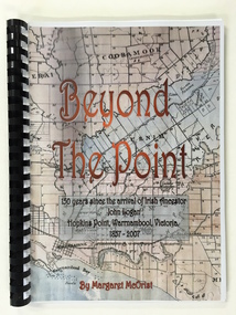
Booklet, Beyond the Point, 2007
... Warrnambool and District Historical Society Inc. 2 Gilles Street (south of Merri St) Warrnambool great-ocean-road This book was written in 2007 by Margaret McOrist to mark the 150th anniversary of the arrival in the Warrnambool area of John Logan. It is a sequel to a 1991 book, ‘Clotted Cream and Mangels’ which told the story of John Logan and his wife Mary Gardner. They lived at Hopkins ...This book was written in 2007 by Margaret McOrist to mark the 150th anniversary of the arrival in the Warrnambool area of John Logan. It is a sequel to a 1991 book, ‘Clotted Cream and Mangels’ which told the story of John Logan and his wife Mary Gardner. They lived at Hopkins Point, Warrnambool and the book, ‘Beyond the Point’ tells the story of the Logan descendants. When the farm land was sub-divided and sold the nearby beach was named ‘Logans Beach’. This book is of considerable interest as it tells the story of the descendants of important early settlers, John Logan and Mary Gardner. The area where they first settled is now of major interest as Logans Beach (named for the Logan family) is the well-known whale watching area. Southern Right Whales return to this beach each year and the females calve and remain up to three months at this beach, making it an important ‘whale nursery’. This is a soft cover book with black plastic ring binding and clear plastic sheets covering the front and back paper covers. The front cover has a reproduction of an 1891 map of Warrnambool and district with the title of the book and other information superimposed on the map. The back cover is black. The book has 101 pages and contains information on the Logan families who lived at Tooram in Allansford and their descendants. There are many black and white and colour photographs, diagrams, maps and family trees. Front Cover: ‘Beyond the Point, 150 years since the arrival of Irish ancestor, John Logan, Hopkins Point, Warrnambool, Victoria, 1857-2007, by Margaret McOrist’. john logan and mary gardner, hopkins point, logans beach, tooram, history of warrnambool -
 Warrnambool and District Historical Society Inc.
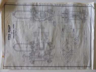
Documents, Technical Drawings Feed Pump
... Hopkins Hill near Allansford and later took up grazing beef cattle. Warrnambool Technical School was established in 1913, and was located first on a Timor Street site and later moved to Caramut Road. ...road These drawings have been produced in 1919 by Ron Uebergang when he was a pupil at the Warrnambool Technical School. The Uebergang families were pioneers in the Warrnambool/Allansford area. Ronald Uebergang (1903-1971) was born in Warrnambool to Ernest Uebergang and Mary Watson. He went to Allansford State School and Warrnambool Technical School and married Myra Hall. He was mechanically-minded, a good photographer and fond of music and dancing. He and Myra had a dairy farm at the family property, Hopkins ...These drawings have been produced in 1919 by Ron Uebergang when he was a pupil at the Warrnambool Technical School. The Uebergang families were pioneers in the Warrnambool/Allansford area. Ronald Uebergang (1903-1971) was born in Warrnambool to Ernest Uebergang and Mary Watson. He went to Allansford State School and Warrnambool Technical School and married Myra Hall. He was mechanically-minded, a good photographer and fond of music and dancing. He and Myra had a dairy farm at the family property, Hopkins Hill near Allansford and later took up grazing beef cattle. Warrnambool Technical School was established in 1913, and was located first on a Timor Street site and later moved to Caramut Road. Today it is called Brauer College. These drawings are of considerable interest because they were produced by Ron Uebergang and the Uebergang families have been prominent in the history of the Warrnambool and Allansford areas since the 1850s. They are also of interest as examples of the type of work produced by students of Warrnambool Technical School in its early days. .1 A Blueprint for a Feed Pump for a Horizontal Engine - blue background, white drawings. The drawing is two-thirds of the full size object. .2 The same drawing on white see-through paper. The paper has a thick line drawn around the edges in black ink. .3 The same drawing on plain white card with drawings in black ink and a thick line drawn around the edges in black ink. .4 The original brown paper covering used to send the drawings to Warrnambool Technical School in 1921. There are also two pages of handwritten material attached to the drawings by a metal clip and giving a description of the design of the Feed Pump. ‘Warrnambool Technical School’ ‘Designed by R. Uebergang’ ‘Drawn by R. Uebergang’ ‘Date 7/10/19’ ronald uebergang, warrnambool technical school, history of allansford, history of warrnambool -
 Warrnambool and District Historical Society Inc.
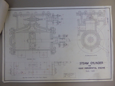
Document, Steam Cylinder Horizontal Engin, 1919
... Hopkins Hill and later went in for grazing beef cattle. Warrnambool Technical School was established in 1913, firstly at a Timor Street site and later at Caramut Road. ...Hopkins Hill and later went in for grazing beef cattle. Warrnambool Technical School was established in 1913, firstly at a Timor Street site and later at Caramut Road. ...This drawing was produced by Ron Uebergang in 1919 at the Warrnambool Technical School. Members of the Uebergang families have been in the Warrnambool/Allansford area since the early 1850s. Ronald Uebergang (1903-1971) was born in Warrnambool, the son of Ernest Uebergang and Mary Watson. He lived at the family property, Hopkins Hill, and went to Allansford State School and Warrnambool Technical School. He was mechanically-minded, fond of music and dancing and a keen photographer. He married Myra Hall and they ran a dairy farm at Hopkins Hill and later went in for grazing beef cattle. Warrnambool Technical School was established in 1913, firstly at a Timor Street site and later at Caramut Road. Today it is called Brauer College. This drawing is of considerable interest as it was produced by Ron Uebergang. Members of the Uebergang families have been prominent in the Warrnambool/Allansford area since the early days of the district’s establishment. It is also important as a good example of the type of work produced by students from Warrnambool Technical School in its early years. This is a1919 drawing of a Steam Cylinder for a 45 HP Horizontal Engine. The drawing is half the full size of the cylinder. The drawing is on a white card with the sketches done in black and red ink. The card has a heavy black margin around the edges drawn in black ink. The drawing shows a Sectional Plan and a Half Side Elevation with the Cover Plate Removed. The card has the signature of Ron Uebergang. Attached by a metal clip to the card are four pages of measurements and plans of the steam cylinder. These are in black and red ink. Three of these pages have become partly detached. ‘Designed by R. Uebergang’ ‘Drawn by R. Uebergang’ ‘Date 1/12/19’ ronald uebergang, warrnambool technical school, history of allansford, history of warrnambool -
 Warrnambool and District Historical Society Inc.
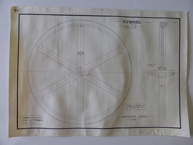
Drawing, Warrnambool Tech .1 Fly Wheel.2 Bevel Wheels R Uebergang, 1919
... Hopkins Hill and later grazed beef cattle. Warrnambool Technical School was established in 1913, firstly at a Timor Street site and later at Caramut Road (today it is known as Brauer College). ...Hopkins Hill and later grazed beef cattle. Warrnambool Technical School was established in 1913, firstly at a Timor Street site and later at Caramut Road (today it is known as Brauer College). ...These drawings have been produced by Ron Uebergang at the Warrnambool Technical School in 1919. Uebergang family members were pioneer settlers in the Warrnambool area in the early 1850s. Ronald John Uebergang (1903-1971) was born in Warrnambool to Ernest Uebergang and Mary Watson. Ron Uebergang lived at the family property, Hopkins Hill at Allansford and went to Allansford State School and Warrnambool Technical School. He was mechanically minded, a good photographer and fond of music and dancing. He married Myra Hall and was a dairy farmer at Hopkins Hill and later grazed beef cattle. Warrnambool Technical School was established in 1913, firstly at a Timor Street site and later at Caramut Road (today it is known as Brauer College). These drawing are of considerable interest as works produced by Ron Uebergang. Uebergang family members have been prominent in the Warrnambool-Allansford area since the pioneering days of the district. The drawings also are good examples of the type of work produced by Warrnambool Technical School students in its early years.These are two designs and drawings by Ron Uebergang produced at the Warrnambool Technical School in 1919. They are drawn on white card using black and red ink. The scale of the Flywheel is three inches to one foot and the Bevel Wheels are one-third full size. The drawings are edged with heavy black lines. The two sheets have the signature of Ron Uebergang. There are also four pages of handwritten notes on the Flywheel and Bevel Wheels.‘Designed by R. Uebergang’ ‘Drawn by R.Uebergang’ ‘Date 4/1/19’ (on Flywheel sheet) ‘Date 27/5/19’ (on Bevel Wheels sheet) warrnambool technical school, ronald uebergang, history of allansford -
 Warrnambool and District Historical Society Inc.
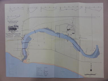
Map - An Angler's map of the Hopkins River Estuary, Angler's map Hopkins River, 1980s
... Warrnambool and District Historical Society Inc. 2 Gilles Street (south of Merri St) Warrnambool great-ocean-road This is a map of the Hopkins River Estuary prepared by Dr John Sherwood for the benefit of anglers. ...This is a map of the Hopkins River Estuary prepared by Dr John Sherwood for the benefit of anglers. The information on the sheet includes the location of sand banks, the water depths, boat ramp facilities and public access facilities. Some of the information has been gathered from aerial photographs. The map has been produced by the Warrnambool Institute of Advanced Education which was developed in the late 1960s from the tertiary section of the Warrnambool Technical College and with all its departments established by 1984 at the Sherwood Campus five kilometres from Warrnambool on the Princes Highway. Today the site is occupied by Deakin University, Warrnambool campus. The Warrnambool Anglers’ Club has its headquarters on the banks of the Hopkins River near the mouth of the river and the Lyndoch Aged Care facility.This map is of interest as a specialist one, providing fishermen with detailed information on all aspects of the Hopkins river estuary. Fishing has been both a profession and a popular recreational pursuit for Warrnambool residents since the early days of the city’s settlement. The Hopkins River Estuary has been a focal point for fishermen throughout Warrnambool’s history. This is a sheet of paper folded three times to produce a folded map. The front cover has a black and white photograph of two fishermen with a large fish. The map of the Hopkins River Estuary is in yellow, blue and black and covers the side of one sheet and three quarters of the other side. There is an advertisement for the Hopkins River Boathouse with a black and white sketch of the boathouse and notes on the map written by Dr John Sherwood. There are several diagrams showing the water depths. The map has some silverfish damage and some tearing at the folds. warrnambool anglers’ club, history of warrnambool, hopkins river, hopkins river estuary, john sherwood -
 Warrnambool and District Historical Society Inc.
Note Book, Engineering Drawings, 1919-21
... road This note book contains handwritten material by Ron Uebergang – notes on engineering drawings prepared for a class at Warrnambool Technical School 1919-1921. Ronald Uebergang (1903-1971) was the son of Ernest and Mary Uebergang. He attended Allansford State School and Warrnambool Technical School and spent his working life dairying and raising cattle on the family property, Hopkins Hill, at Allansford, about nine kilometres east of Warrnambool. ...This note book contains handwritten material by Ron Uebergang – notes on engineering drawings prepared for a class at Warrnambool Technical School 1919-1921. Ronald Uebergang (1903-1971) was the son of Ernest and Mary Uebergang. He attended Allansford State School and Warrnambool Technical School and spent his working life dairying and raising cattle on the family property, Hopkins Hill, at Allansford, about nine kilometres east of Warrnambool. He was mechanically minded, fond of music and dancing and a keen photographer. These notes are of interest as they were compiled by Ron Uebergang when he was a student at Warrnambool Technical School 1919-21. The Uebergang families were pioneering settlers in the Allansford area and have been prominent farmers in the area from the 1850s on. The notes also are a good example of the work done by students at Warrnambool Technical School in the 1920s. This is a hand-made book of 22 pages with notes on engineering drawings by Ron Uebergang handwritten in black ink. There is tissue paper inserted between some of the pages. There are several drawings and equations in with the handwritten material. There is some silver fish damage on the front cover. Front Cover: ‘R. Uebergang’ ‘Note Book for Engineering Drawing Grade 3’ ronald uebergang, warrnambool technical school, history of allansford, history of warrnambool -
 Warrnambool and District Historical Society Inc.
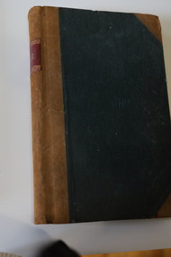
Administrative record - Bakery Ledger, Andrew Jack, Dyson & Co., Melbourne, Baker's Ledger, 1940s
... road This ledger comes from the Model Bakery business of G.W. Greaves, a baker and pastrycook In Allansford in the first half of the 20th century. Allansford is a township 10 kilometres east of Warrnambool, now incorporated into the City of Warrnambool. The ledger contains details of the Greaves business sales of goods, mostly bread, from 1946 to 1948 and includes the names of the customers, the orders and the moneys owing. The bakery served many nearby areas including Wangoom, Hopkins ...This ledger comes from the Model Bakery business of G.W. Greaves, a baker and pastrycook In Allansford in the first half of the 20th century. Allansford is a township 10 kilometres east of Warrnambool, now incorporated into the City of Warrnambool. The ledger contains details of the Greaves business sales of goods, mostly bread, from 1946 to 1948 and includes the names of the customers, the orders and the moneys owing. The bakery served many nearby areas including Wangoom, Hopkins Point, Cudgee, Mepunga, Naringal and Lake Glllear. This ledger is of interest as it illustrates the size of the Allansford bakery and contains many names of people in the area in the 1940s, making it a valuable research object.This is a ledger with a black cover and leather coverings at the corners and a brown leather spine. The red label on the spine has gold lettering and ornamental edges. The inside of the cover has a red mottled pattern and has tape and string stitching. A maker's label is also inside the front cover. The pages are ruled with red lines and contain handwritten entries. There are some loose invoices. The cover is very faded and stained.Baker's Ledger Andrew Jack, Dyson & Co. Wholesale Stationersallansford bakery, greaves model bakery -
 Warrnambool and District Historical Society Inc.
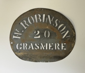
Functional object - Robinson Farm Labelling Stencil, c.1950
... road This stencil has been made to label packaged produce (wool bales, packaged meat etc) from a farm in Grasmere, near Warrnambool. The name, W. Robinson, suggests that this is William Robinson the son of James and Jane Robinson. James Robinson came to Australia in 1857 and he and his family farmed at Springvale at Hopkins ...This stencil has been made to label packaged produce (wool bales, packaged meat etc) from a farm in Grasmere, near Warrnambool. The name, W. Robinson, suggests that this is William Robinson the son of James and Jane Robinson. James Robinson came to Australia in 1857 and he and his family farmed at Springvale at Hopkins Point, then at what was termed 'Manning's old Purnim Farm' on the Merri Rive at Grasmere (the Manning brothers, Frederick and John were early farmers in the district). The Robinson brothers, James and Stuart were well-known in the Warrnambool district as champion ploughmen. James's son, William married firstly Christina MacLennan and then Elizabeth Neale of Tooram, Allansford. William died in 1959 but the stencil was probably used on the property after his death. This farm stencil is of interest as a memento of farming at Grasmere in the first half of the 20th century.This is a metal stencil, oval in shape. It has letters cut out in the metal for stencilling purposes. It has been painted or sprayed and is rusted in places.W. Robinson 20 Grasmerewilliam robinson grasmere, manning's purnim farm -
 Warrnambool and District Historical Society Inc.
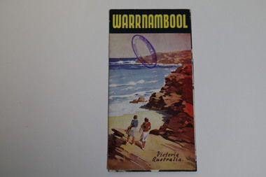
Pamphlet - Tourist Map and Guide, Victorian Railway Commissioners, Warrnambool Victoria Australia, c. 1950
... Warrnambool and District Historical Society Inc. 2 Gilles Street (south of Merri St) Warrnambool great-ocean-road This pamphlet wa issued by the Victorian Railways about 1950 in conjunction with the Warrnambool Ratepayers' Association. It has a map of Warrnambool, text on Warrnambool's attractions and several photographs of local scenic spots, including the Botanic Gardens, Hopkins River, the beach, the C.B.D. and coastal views. ...Warrnambool Tourist Map and Guide.1 This is a single sheet of paper folded twice to make a pamphlet. It has a multi-coloured map (predominantly yellow), an illustration, several black and white photographs, printed text and coloured headings. .2 This is a single sheet of paper inserted into item 1. It is folded twice and contains black and white photographs.non-fictionWarrnambool Tourist Map and Guidetourism in warrnambool, warrnambool rail, warrnambool tourist guides -
 Warrnambool and District Historical Society Inc.
Administrative record - Ledgers (2) - Bruce & McClure, Bruce & McClure business administrators, Petty Cash Book; Share Register, 1916-1945
... Hopkins and in the 1890s by the engineering works of Dobson and Parkinson. Bruce and McClure were engineers, ironfounders and windmill makers and manufactured, produced and serviced farm equipment in a wide area around Warrnambool. In 1945 the business was purchased by the Owen Brothers who later relocated to Caramut Road...road These two ledgers come from the Warrnambool business of Bruce and McClure. One ledger is a Petty Cash Book with entries dating from 1941 to1945 and the other is a Share Register with entries from 1916 to 1933. The business of Bruce and McClure was located at 159-165 Lava Street Warrnambool and was established about 1900 in premises originally occupied by the plumber and fitter, W. Flett and the blacksmith and farrier, W. Hopkins ...These two ledgers come from the Warrnambool business of Bruce and McClure. One ledger is a Petty Cash Book with entries dating from 1941 to1945 and the other is a Share Register with entries from 1916 to 1933. The business of Bruce and McClure was located at 159-165 Lava Street Warrnambool and was established about 1900 in premises originally occupied by the plumber and fitter, W. Flett and the blacksmith and farrier, W. Hopkins and in the 1890s by the engineering works of Dobson and Parkinson. Bruce and McClure were engineers, ironfounders and windmill makers and manufactured, produced and serviced farm equipment in a wide area around Warrnambool. In 1945 the business was purchased by the Owen Brothers who later relocated to Caramut Road Warrnambool where it still operates today. These ledgers are of historic interest as they contain details of the operations of an important 20th century business in Warrnambool (Bruce & McClure) and they are very useful for local research. .1 Ledger with a hard green cover and dark red binding. The pages contain red and blue lines and handwritten entries in ink. Some pages are loose and there are some inserts with typed sheets. .2 Ledger with a green cover and dark red binding on the spine. There are alphabetical tabs in the front of the book and the pages contain printed red and blue lines and printed headings. The entries are handwritten in ink. Most of the pages are empty.bruce & mcclure warrnambool, windmill makers warrnambool, owens of warrnambool -
 Warrnambool and District Historical Society Inc.
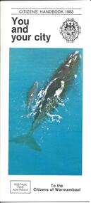
Booklet - City of Warrnambool Citizens' Handbook 1983
... road This Citizens' Handbook was posted to all citizens of Warrnambool in 1983. It contains an introductory message from the Mayor of the time, Cr. Ron Anderson and information relating to council run facilities and services. There is a page explaining the Warrnambool Bike plan and a section on how to save water. The blue centre pages explains property valuations and how to pay council rates. The rear page lists the contact details for councillors from each of the four municipal wards (Albert, Hopkins ...This Citizens' Handbook was posted to all citizens of Warrnambool in 1983. It contains an introductory message from the Mayor of the time, Cr. Ron Anderson and information relating to council run facilities and services. There is a page explaining the Warrnambool Bike plan and a section on how to save water. The blue centre pages explains property valuations and how to pay council rates. The rear page lists the contact details for councillors from each of the four municipal wards (Albert, Hopkins, Merri, Victoria) This booklet is an example of information provided to all City of Warrnambool citizen's in 1983. It gives an overview of council run facilities and services in 1983 and will be useful for researchers.A 20 page stapled booklet. Sixteen pages are printed on glossy white paper with black print. The centre pages are blue with black printing. The front cover has a black and white City of Warrnambool crest in the top right and a colour photograph of a Southern Right whale and calf swimming in the sea. The bottom left hand corner of the front cover has a postage paid rectangle printed in black print. The left hand side of the back cover has four ward maps printed in yellow and red. The ward names are printed in blue and the Councillor's details are in smaller brank print.Front Cover: Citizens' Handbook 1983 You and your city; Postage Paid Australia; To the Citizens of Warrnambool Back Cover: Your Ward Councillors Albert Hopkins Merri Victoriawarrnambool city council, citizens' handbook, warrnambool performing arts centre, warrnambool bike plan, albert ward, hopkins ward, merri ward, victoria ward -
 Warrnambool and District Historical Society Inc.
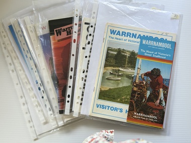
Booklet - Warrnambool Visitor's Handbooks 1979-2024, Collett, Bain and Gaspar, Printers, 1979-2014
... Road Victoria [.1a] A 48 page booklet with white pages and blue printing. The front cover has a coloured photograph of Flagstaff Hill with boats on a man made lake in the foreground looking across Lake Pertobe toward South Warrnambool. [.1b] A coloured bifold brochure. The front cover has a fisherman on a cray-boat holding a crayfish in the lower section. The top quarter has a blue back ground with white printing. The rear cover is red and has small photos of the Hopkins ...This is a collection of eight Warrnambool Visitor handbooks produced between 1979 and 2014 by the City of Warrnambool Tourist Information Centre. They contain maps of Warrnambool, lists of services, accommodation and tourist attractions as well as many advertisements for local businesses.These handbooks give a useful snapshot of businesses and tourist attractions in Warrnambool for each of the years covered. (1979, 1980, 1986, 1990, 1993, 1994, 1995, 2014)[.1a] A 48 page booklet with white pages and blue printing. The front cover has a coloured photograph of Flagstaff Hill with boats on a man made lake in the foreground looking across Lake Pertobe toward South Warrnambool. [.1b] A coloured bifold brochure. The front cover has a fisherman on a cray-boat holding a crayfish in the lower section. The top quarter has a blue back ground with white printing. The rear cover is red and has small photos of the Hopkins River and the Framlingham Forest. [.2] A 48 page booklet with white pages and black printing. The front cover is white with black writing on the left hand side and a colour photograph of the Loch Ard peacock. The Warrnambool Premier Town stylised logo of seven Norfollk pines above blue waves is in the top right hand corner. There is a blank ink Warrnambool Library stamp underneath the logo. The rear cover has photographs of The Twelve Apostles and the Hopkins Falls and the Premier Town Logo [.3] A 40 page booklet with mainly black printing on white paper. There are three fold out maps of Warrnambool and the surrounding district. The glossy cover has a black background with a colour photograph of the Twelve Apostles taken at sunset. The rear cover has three small of Proudfoot's boathouse on the Hopkins River, Flagstaff Hill, and the main beach area. The front cover has black writing inside to peach coloured rectangles. The inside rear cover has a fold out coloured tour map of Western Victoria. [.4] A 40 page booklet printed on glossy white paper with coloured photographs and black and red printing. The front cover has a photograph of The Twelve Apostles surrounded by a white border. There is red writing in the upper border. There is a sandy coloured writing superimposed across the bottom of the photograph and a Victoria's Shipwreck Coast logo in the bottom right hand corner. [.5] A 44 page booklet printed on white paper with black printing. The cream coloured cover has a pale red rectangle with blue writing on the right hand facing edge and includes two stylised Norfolk pines and with waves underneath. There is is an intersecting blue rectangle with cream printing. [.6] A 48 page booklet printed on white paper with black printing. The cover is brown with a cream vertical strip containing black writing on the right hand side. There is a stylised map from Geelong to Mount Gambier showing the Great Ocean Road across the cover. [.7] A 48 page booklet printed on white paper with black print. The glossy colour cover has a photograph of a Southern Right whale fluke. There is white printing on a the blue background of the sky and sea. The bottom left hand side of the front cover has a Tourism Victoria logo made of jigsaw puzzle pieces. The back cover has a stylised coloured map of The Great Ocean Road located in a white rectangle at the top of the page. Within the rectangle is a small map of Australia locating Victoria and the part of Victoria covered by the map. [.8] A 64 page A5 coloured booklet printed on white pages with black print. The white front cover has black and grey print with a colour photograph of two people holding coffee cups watching four race horses being exercised on the beach and in the water of Lady Bay in the early morning. The bottom right hand corner has a Tourism Victoria logo. The rear cover has a mainly blue back ground with a pink orange and green colour splats contains words advertising the 2015 Fun 4 Kids Festival [.1a] Warrnambool The Heart of Victoria's Great Southwest Visitor's Handbook [.1b] Warrnambool City for all seasons; The Heart of Victoria's Great Southwest [.2] Warrnambool visitor's handbook Warrnambool Premier Town 1979-1982 [.3] Warrnambool Handbook Victoria [.4] Warrnambool The Shipwreck Coast [.5] Welcome to Warrnambool Warrnambool Visitors Handbook 1993-1994 [.6] Welcome to Warrnambool Visitors Handbook 1994-95 Rear cover: Warrnambool Centre of Victoria's Shipwreck Coast on Australia's Great Ocean Road [.7] Warrnambool Shipwreck Coast - Great Ocean Road; You'll love every piece of Victoria; Visitors Handbook [.8] Warrnambool Great Ocean Road Official Visitor Guide; It's a wonderful Warrnambool; You'll love every piece of Victoria visitvictoria.com. Rear Cover Live entertainment.Workshops.Creativity.Action 28 June - 5 July 2015 Australia's Best Children's Festival F4K The ultimate winter school holiday adventure Fun 4 kids festival Warrnambool For more information visit Fun4kids.com.au Warrnambool great Ocean Road Victoriawarrnambool, visitor handbooks, tourist information guides, warrnambool maps -
 Warrnambool and District Historical Society Inc.
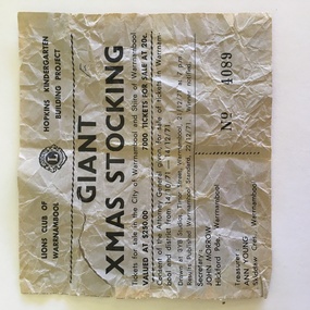
Docket, Giant Xmas Stocking, 1971
... road This portion of a raffle ticket is from a raffle conducted by the Warrnambool Lions Club in 1971. The proceeds went towards the building fund of a Warrnambool kindergarten which is at 31 Gladstone Street, Warrnambool and is today known as the Lions Hopkins Kindergarten. ...This portion of a raffle ticket is from a raffle conducted by the Warrnambool Lions Club in 1971. The proceeds went towards the building fund of a Warrnambool kindergarten which is at 31 Gladstone Street, Warrnambool and is today known as the Lions Hopkins Kindergarten. The Warrnambool Lions Club was formed in 1959 and was chartered in May 1960. At the time the charter presentation was the largest charter night gathering ever held in Australia (210 people present). The Warrnambool Lions Club continues to operate as a service club. This raffle ticket is of interest as an early example of the fundraising efforts of the Warrnambool Lions ClubThis is a piece of paper, now much yellowed. It is one section of a raffle ticket and has black printing and the Lions Club logo. It is partly torn. Lions Club of Warrnambool, Hopkins Kindergarten Building Project Giant Xmas Stocking. warrnambool lions club, lions hopkins kindergarten warrnambool -
 Warrnambool and District Historical Society Inc.
Medal, Warrnambool R.C Regatta
... road This Warrnambool Rowing Club medal was awarded to the winners of the Society Fours in 1908. The Friendly Society group that won the race was the Manchester Unity Independent Order of Odd Fellows, a benefit society owned by members who assist other members in times of illness or unemployment. Originally founded in Manchester, England, the M.U.I.O.O.F. started in Melbourne in 1840. The Warrnambool branch was founded in 1860. The Warrnmbool Rowing Club was established in 1873, though there had been several boat clubs associated with the Hopkins ...This Warrnambool Rowing Club medal was awarded to the winners of the Society Fours in 1908. The Friendly Society group that won the race was the Manchester Unity Independent Order of Odd Fellows, a benefit society owned by members who assist other members in times of illness or unemployment. Originally founded in Manchester, England, the M.U.I.O.O.F. started in Melbourne in 1840. The Warrnambool branch was founded in 1860. The Warrnmbool Rowing Club was established in 1873, though there had been several boat clubs associated with the Hopkins River going back to the 1850s. No information has been found on R.Russell. This medal is of interest as a memento of a Warrnambool sporting club award in 1908 and of the winner of the award, a Warrnambool group and a member of that group.This circular brass medal has a shield shaped centrepiece with text on both obverse and reverse surrounded by a plain annulus edged with small scrolls. It has a ring at the top.Obverse- W.R.C. Regatta 1908 Reverse SOCIETY FOURS Won by M.U.I.O.O.F.R RUSSELL. A maker's hallmark.warrnambool rowing club, the friendly society, m.u.i.o.o.f. -
 Warrnambool and District Historical Society Inc.
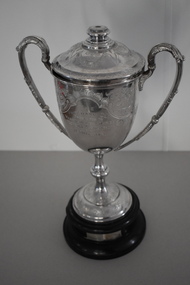
Trophy, Walker & Hall Ltd Silversmiths, Pritchard cup, 1920s
... road This is a trophy given to a Warrnambool Football Association by Harry Pritchard. He was a Warrnambool businessman who had the Warrnambool Sports Depot store in Kepler Street in the 1920s. The trophy was for the winner of the Warrnambool Wards Football Association. This was a Junior Association promoted by the Warrnambool Football Club and it existed from 1924 to 1930. It was proposed that the four Council Wards, Hopkins ...This is a trophy given to a Warrnambool Football Association by Harry Pritchard. He was a Warrnambool businessman who had the Warrnambool Sports Depot store in Kepler Street in the 1920s. The trophy was for the winner of the Warrnambool Wards Football Association. This was a Junior Association promoted by the Warrnambool Football Club and it existed from 1924 to 1930. It was proposed that the four Council Wards, Hopkins, Victoria, Albert and Merri each had a football team but it is not clear if all had teams and how many teams from other areas took part in the competition. The Pritchard Cup records that the Hopkins Ward Football Team won the trophy in 1926 and that Allansford, a team outside of the four wards, won in 1927. The records of the Allansford Football Club go back to the 1890s. This cup is of considerable interest, firstly as an attractive trophy in its own right and secondly as a memento of a football association connected with the Warrnambool Council Wards. Both the Council Wards structure and the Wards football association no longer exist. This is a silver cup with two ornamental handles, a slender stem and a silver base. The cup has a lid with a knob in the middle. The cup, lid and base are all heavily etched and patterned with scrolls, leaves and flowers. There is an inscription on one side of the cup. The cup sits on a circular brown wooden base which has a cloth or paste mixture affixed to the bottom. The wooden section has two silver plaques with inscriptions. There is a small piece of wood missing on the side of the top of the mount. ‘The Pritchard Cup presented to Warrnambool Ward’s (sic) Football Association by H. Pritchard.’ ‘Won by Hopkins Ward Football Club Season 1926’ ‘Won by Allansford Football Club Season 1927’ football in warrnambool district, harry pritchard, warrnambool 1920s, history of warrnambool -
 Warrnambool and District Historical Society Inc.
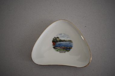
Artefact, Alka, Dish, Mid 20th century
... road This souvenir dish has been made by the German firm of Alka. The name comes from the surnames of the two proprietors, Alboth and Kaiser. This type of dish was made between 1938 and 1958. Tourism has been an important industry in the Warrnambool area for over 100 years and souvenir dishes of this kind were a popular buy by the visiting tourists. The dish features a scene from the Hopkins ...This souvenir dish has been made by the German firm of Alka. The name comes from the surnames of the two proprietors, Alboth and Kaiser. This type of dish was made between 1938 and 1958. Tourism has been an important industry in the Warrnambool area for over 100 years and souvenir dishes of this kind were a popular buy by the visiting tourists. The dish features a scene from the Hopkins River, a fishing and recreational area in Warrnambool since the early days of European settlement. Souvenir dishes such as this one can be sometimes found in local second hand and opportunity shops. This dish is of interest as an example of the high-quality souvenirs bought by local tourists in the Warrnambool area in the mid 20th century.This is a china dish made in a rounded-edged triangular shape. The rim is gilt-edged. In the centre of the dish is a coloured sketch/photograph of the Hopkins River in Warrnambool (Clifton Banks region). ‘Warrnambool Hopkins River’ ‘Alka Bavaria Germany’ tourism in warrnambool, hopkins river, warrnambool, history of warrnambool -
 Warrnambool and District Historical Society Inc.
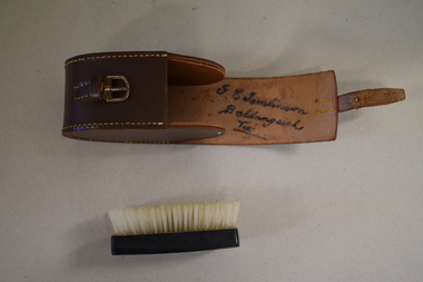
Clothes brush & holder, Mid 20th century
... road The brush in this case could have been used as a hair brush or a clothes brush. It is enclosed in a leather case and was probably an item made for travellers. The brush and case belonged to George Tomlinson of Ballangeich. Ballangeich is a small settlement on the Hopkins ...The brush in this case could have been used as a hair brush or a clothes brush. It is enclosed in a leather case and was probably an item made for travellers. The brush and case belonged to George Tomlinson of Ballangeich. Ballangeich is a small settlement on the Hopkins Highway about 27 kilometres from Warrambool. George Tomlinson’s grandfather, William Tomlinson , established a farming property at Ballangeich in 1865 and opened a hotel, ‘Half Way House’ on part of the land. George Tomlinson’s father, also William, continued to farm in the area and was known as a fine judge of cattle and sheep. This case and brush are of interest as an example of the brushes men used in the mid 20th century. The items are also of interest as they belonged to a member of a well-known Ballangeich family (Tomlinsons).1 This is a piece of brown leather rolled over and stitched with yellow thread to form a container or case. The case has a closing mechanism – a leather strap and metal buckle. .2 Inside the leather case is a brush with a brown Bakelite back with horsehair inserted. ‘G.E. Tomlinson Ballangeich Victoria’men’s toiletries, ballangeich, history of warrnambool -
 Warrnambool and District Historical Society Inc.
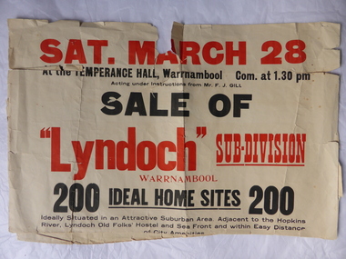
Poster, Lyndoch Sub-Division
... road This is a poster advertising the sale of the Lyndoch sub-division in Warrnambool with the sale of 200 housing sites. The sale took place about 1958 with the land sold by Frederick Gill, a Warrnambool jeweller. The land was previously owned by George Rolfe who had acquired the land near the mouth of the Hopkins ...This is a poster advertising the sale of the Lyndoch sub-division in Warrnambool with the sale of 200 housing sites. The sale took place about 1958 with the land sold by Frederick Gill, a Warrnambool jeweller. The land was previously owned by George Rolfe who had acquired the land near the mouth of the Hopkins River in the 1880s and named the property ‘Lyndoch’. He bought the surrounding land at a later time. This sub-division came to be known as the Gill Estate. It was a valuable site as many of the allotments fronted the sea and others were adjacent to the Hopkins River. This poster, although tattered, is of interest as it has many details of the Gill Estate sub-division and will be useful to researchers. This is a cream-coloured paper poster with black and red printing. The poster has a small map in a circle shape showing the location of the streets and a larger map section showing the streets and the allotments to be sold. The poster is in two pieces and the edges are torn and, in some sections, missing. The streets map has some pencil annotations. history of warrnambool, lyndoch, warrnambool, george rolfe, frederick gill -
 Warrnambool and District Historical Society Inc.
Jug, Souvenir Warrnambool Jug, Between 1921 and 1938
... Warrnambool and District Historical Society Inc. 2 Gilles Street (south of Merri St) Warrnambool great-ocean-road This is a souvenir jug showing an image of the boat sheds (Proudfoots) at the mouth of the Hopkins River, Warrnambool. ...This is a souvenir jug showing an image of the boat sheds (Proudfoots) at the mouth of the Hopkins River, Warrnambool. It would have been purchased in the 1920s or 1930s. These boatsheds were erected for Thomas Proudfoot in 1885. At that time the sheds housed the boats of the local Gordon Rowing Club. This jug is of interest as an example of the type of souvenir available to tourists and locals in the Warrnambool district in the 1920s and 30s. This is a lustre ware china jug with a black handle and a black lip and black edging around the opening. The jug has a squat spherical shape and has gold colouring with an image in black and grey of the boatsheds at the mouth of the Hopkins River, Warrnambool. The lettering is in black and on the base are the maker’s symbols. ‘Boat Houses on the Hopkins, Warrnambool ’23 R.K.G. Made in Cechoslov (sic)’ proudfoots boatsheds. warrnambool, hopkins river, warrnambool, history of warrnambool -
 Warrnambool and District Historical Society Inc.
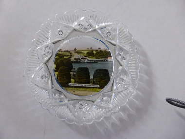
Platter, Transfer Hopkins River
... Warrnambool and District Historical Society Inc. 2 Gilles Street (south of Merri St) Warrnambool great-ocean-road This is a souvenir dish or small plate with an illustration of the Hopkins River in Warrnambool. ...This is a souvenir dish or small plate with an illustration of the Hopkins River in Warrnambool. Included in the illustration are the rowing shed, the boathouses and the lambertiana trees in the property of Lyndoch. The souvenir dish would have been sold to tourists visiting Warrnambool or Warrnambool residents in the 1920s and 30s. This type of souvenir was popular at the time in any tourist town or place in Australia. Tourism has been an important industry in Warrnambool since the late 19th century. This item is of interest as an example of the type of souvenir produced for tourists in the 1920s and 30s. It was both a useful and decorative item. It will be useful for display. This is a small glass souvenir dish. The centre of the dish features a colour illustration of the Hopkins River, Warrnambool (near its mouth). The glass around the illustration is heavily patterned and embossed. The bottom of the dish is dark blue. ‘Hopkins River Warrnambool’ tourism in warrnambool, warrnambool history -
 Warrnambool and District Historical Society Inc.
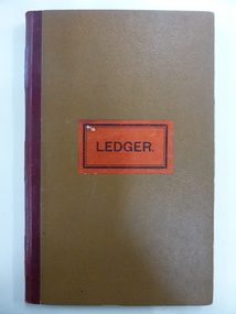
Document - Ledger, Standard Articles, Mid 20th century
... Warrnambool and District Historical Society Inc. 2 Gilles Street (south of Merri St) Warrnambool great-ocean-road This ledger contains original Warrnambool Standard newspaper cuttings of the eleven articles written by Henri Worland on the early history of Warrnambool. The subject matter includes the Post and Telegraph Office, Punts over the Merri and Hopkins Rivers, Transport in the Early Days, Early Exploration, Minjah Station and the History of the Breakwater. ...This ledger contains original Warrnambool Standard newspaper cuttings of the eleven articles written by Henri Worland on the early history of Warrnambool. The subject matter includes the Post and Telegraph Office, Punts over the Merri and Hopkins Rivers, Transport in the Early Days, Early Exploration, Minjah Station and the History of the Breakwater. Henri Worland (1883-1972) was Warrnambool’s most important 20th century local historian. He was the Town Clerk of Warrnambool from 1918 to 1949 and his intense interest in Warrnambool’s history led him to collect and preserve a great amount of local history material. He wrote extensively on Warrnambool’s history and gave talks on the local radio station over a period of many years.These newspaper cuttings are of interest as examples of the many local history articles written by the important Warrnambool historian Henri Worland. The Warrnambool and District Historical Society has a collection of Worland’s original writings in his own handwriting. This is a ledger book with a brown-coloured cover with red binding. There is a label pasted on to the front cover with black printing on it. The ledger has indented alphabet tabs and the pages are ruled with red lines for ledger purposes but these have not been used. The ledger has been used to paste in original cuttings from the Warrnambool Standard newspaper (Henri Worland articles from the 1940s). One page contains two copies of old photographs. Some of the pages have been reinforced with staples and some pages have become detached from the binding. ‘Ledger’ henri worland, history of warrnambool -
 Warrnambool and District Historical Society Inc.
Sale Poster, Mercer Print, "Arran" 1967, 1967
... road This Auction notice is for the sale of an Ellerslie property called "Arran" , owned by Mr Philip M. Ormsby. The date of the auction is Thursday 16th February 1967. Vendors solicitors are Archer Naughtin and Forrest of Mortlake and the sale agents are Dennys, Lascelles Limited. Portions of "Arran" had been in the family since 1865. The property has 3/4 mile frontage to the Hopkins ...This Auction notice is for the sale of an Ellerslie property called "Arran" , owned by Mr Philip M. Ormsby. The date of the auction is Thursday 16th February 1967. Vendors solicitors are Archer Naughtin and Forrest of Mortlake and the sale agents are Dennys, Lascelles Limited. Portions of "Arran" had been in the family since 1865. The property has 3/4 mile frontage to the Hopkins river.This sale notice is of general interest as a well established property in a good farming region. Long sheet with sale details of the property Arran The majority of the text is black with some highlighted in red.There is a map of the property on the reverse.warrnambool, arran, ellerslie -
 Warrnambool and District Historical Society Inc.
Map - Maps, Soldiers Settlement WW2, Circa 1950
... road The soldiers' settlement scheme operated after the first and second world wars in an effort to more closely settle the land and also give opportunities to returned soldiers. Crown land and other larger estates were acquired for the purpose. Most of these maps relate to the area north of Warrnambool where many of the subdivisions were parts of larger estates. These maps pertaining to the Soldiers' Settlement program, relate to an interesting part of Australian and local history. As such they have historic and social interest and significance. narrapumelap berrambool hopkins ...The soldiers' settlement scheme operated after the first and second world wars in an effort to more closely settle the land and also give opportunities to returned soldiers. Crown land and other larger estates were acquired for the purpose. Most of these maps relate to the area north of Warrnambool where many of the subdivisions were parts of larger estates.These maps pertaining to the Soldiers' Settlement program, relate to an interesting part of Australian and local history. As such they have historic and social interest and significance.A collection of 25 paper maps which relate to to the soldiers settlement post World War 2. Some have details of the people allocated the land and some smaller maps have the printed details of the applicants requirements.Text is black on white paper which in some cases is quite aged. The maps are as follows: .1 Narrapumelap Estate ( Ripon & Hampden) .2 Narrapumelap Estate Part 2 (Villers & Ripon) .3 Narrapumelap Estate Part 3 ( Villiers & Ripon) .4 Burrumbeet Estate ( Ripon) .5 ' Berrambool' Estate 9 Hampden & Villiers) .6 ' Hopkins Hill' Estate Villiers 4011 acres .7 Caramut North No 2 Estate ( Villiers ) .8 ' Morpor' Estate ( Villiers) 4172 acres .9 ' Morgiana' Estate ( Normandy) 3453 acres .10 ' Chatsworth House' ( Villiers) 9341 Acres .11 ' East Elwood' Estate Villiers 2407 acres .12 Grey's Estate ( Mornington) 1151acres .13 ' Rowes Estate' ( Buln Buln Gippsland 733 acres .14 'Tarrone' Estate No 2 Part map .15 'Chaldon Meade' Estate (Bourke) Bulla 517 acres .16 ' Terranallum South' Estate Hampden 3757 acres .17 ' Brung Brungle' Estate Dundas 695 .18 ' Armidale ' Estate ( Dundas)2108 acres .19 ' Moyne Falls' Estate ( Villiers) 627 acres .20' Yulong' Estate 9 Lowan 6321 acres .21 Murray Valley Irrigation District 9 Moira)113 acres .22 Murray Valley Irrigation District 103 acres .23 ' Mount Fyans' Estate ( Hampden) .24 ' Barwidgee ' Estate ( Villiers) 4277 acres .25 'Pine Hills' Estate 2nd portion ( Lowan) 6190 acres narrapumelap, berrambool, hopkins hill, caramut north, morpor, chatsworth house, east elwood, terrinallum, moyne falls, tarrone, caramut soldiers settlers, burrumbeet, morgiana, grey's estate mornington, chaldon meade, brung brungle