Showing 71 items matching "industrial estates"
-
 Glenelg Shire Council Cultural Collection
Photograph - Photograph - framed collection Ships and industrial estates in Portland, n.d
... Photograph - framed collection Ships and industrial estates in Portland...'Ixion'; 6. Harbur industrial estate - Cape Grant area; 7. Harbour construction 1957; 8. ...'Ixion'/ Harbur industrial estate - Cape Grant area/ Harbour construction 1957/ Cape Grant quarry 1957. ...'Ixion'; 6. Harbur industrial estate - Cape Grant area; 7. Harbour construction 1957; 8. ...UnknownFramed collection of photographs in brown timber frame, under glass. 1. T.S.S. 'Ixion' First vessel berth K.S. Anderson (1959); 2. M.V. 'Athel Princess', first vessel to load bulk oats (1961); 3. Cresco fertiliser - Lady Bay; 4. Portland Bay; 5. T.S.S. 'Ixion'; 6. Harbur industrial estate - Cape Grant area; 7. Harbour construction 1957; 8. Cape Grant quarry 1957.Front: T.S.S. 'Ixion' First vessel berth K.S. Anderson (1959)/ M.V. 'Athel Princess', first vessel to load bulk oats (1961)/ Cresco fertiliser - Lady Bay; 4. Portland Bay/ T.S.S. 'Ixion'/ Harbur industrial estate - Cape Grant area/ Harbour construction 1957/ Cape Grant quarry 1957. Back: (no inscriptions) -
 Hume City Civic Collection
Photograph, 1/12/1982
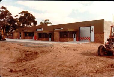
... ...industrial estates...The former Shire of Bulla developed much of this area and leased the space to private companies. factories industrial estates shire of bulla george evans collection A coloured photograph with rounded corners of 4 brick factory units. ...The railway land between Horne Street and the railway line was developed for commercial and industrial purposes during the late 1970s and early 1980s. The former Shire of Bulla developed much of this area and leased the space to private companies.A coloured photograph with rounded corners of 4 brick factory units. There is a large digger on the RHS. The area in front of the units has been paved but the remaining area is unsealed.factories, industrial estates, shire of bulla, george evans collection -
 Lakes Entrance Historical Society
Photograph - Maramingo, 2004
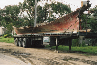
... Colour photograph of the wrecked timber fishing boat, Maramingo on a semi-trailer in the industrial estate, Maramingo was wrecked on eastern spit at the entrance. ...Lakes Entrance Historical Society 4 Marine Parade Lakes Entrance gippsland Vessel wrecked at the entrance 25 April 2004 Ships and Shipping Fishing Industry Shipwrecks Colour photograph of the wrecked timber fishing boat, Maramingo on a semi-trailer in the industrial estate, Maramingo was wrecked on eastern spit at the entrance. ...Vessel wrecked at the entrance 25 April 2004Colour photograph of the wrecked timber fishing boat, Maramingo on a semi-trailer in the industrial estate, Maramingo was wrecked on eastern spit at the entrance. Lakes Entrance Victoriaships and shipping, fishing industry, shipwrecks -
 Lakes Entrance Historical Society
Photograph - Maramingo, 2004
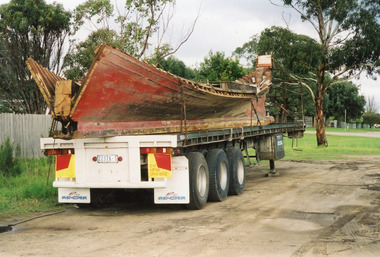
... Colour photograph of the wrecked timber fishing boat, Maramingo on a semi-trailer in the industrial estate, Maramingo was wrecked on eastern spit at the entrance. ...Lakes Entrance Historical Society 4 Marine Parade Lakes Entrance gippsland Vessel wrecked at the entrance 25 April 2005 Ships and Shipping Fishing Industry Shipwrecks Colour photograph of the wrecked timber fishing boat, Maramingo on a semi-trailer in the industrial estate, Maramingo was wrecked on eastern spit at the entrance. ...Vessel wrecked at the entrance 25 April 2005Colour photograph of the wrecked timber fishing boat, Maramingo on a semi-trailer in the industrial estate, Maramingo was wrecked on eastern spit at the entrance. Lakes Entrance Victoriaships and shipping, fishing industry, shipwrecks -
 Lakes Entrance Historical Society
Photograph - Maramingo, 2004
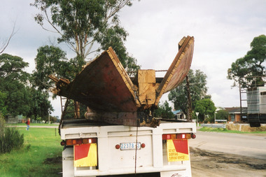
... Colour photograph of the wrecked timber fishing boat, Maramingo on a semi-trailer in the industrial estate, Maramingo was wrecked on eastern spit at the entrance. ...Lakes Entrance Historical Society 4 Marine Parade Lakes Entrance gippsland Vessel wrecked at the entrance 25 April 2006 Ships and Shipping Fishing Industry Shipwrecks Colour photograph of the wrecked timber fishing boat, Maramingo on a semi-trailer in the industrial estate, Maramingo was wrecked on eastern spit at the entrance. ...Vessel wrecked at the entrance 25 April 2006Colour photograph of the wrecked timber fishing boat, Maramingo on a semi-trailer in the industrial estate, Maramingo was wrecked on eastern spit at the entrance. Lakes Entrance Victoriaships and shipping, fishing industry, shipwrecks -
Glenelg Shire Council Cultural Collection
Photograph - Photograph - View of Port of Portland, 21/03/1972
... Cape Nelson Road overpass preparations, canal realignment, railway sidings, canal court industrial estate, Henty Park....Cape Nelson Road overpass preparations, canal realignment, railway sidings, canal court industrial estate, Henty Park. Photograph Photograph - View of Port of Portland Unknown ...Port of Portland Authority archives.Front: (no inscriptions) Back: 21/3/1972port of portland archives, portland harbour, cape nelson road, canal, railway, canal court, henty park -
Glenelg Shire Council Cultural Collection
Photograph - Photograph - View of Portland and foreshore, 21/03/1972
... Railway sidings, council industrial estate, silos and grain storage....Railway sidings, council industrial estate, silos and grain storage. Photograph Photograph - View of Portland and foreshore Unknown ...Port of Portland Authority archives.Front: (no inscriptions) Back: (no inscriptions)port of portland archives, portland harbour -
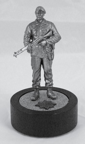 4th/19th Prince of Wales's Light Horse Regiment Unit History Room
Decorative object - Figurine Miniature Soldier with Rifle
... Unit 6A Vinces Road Industrial Estate DISS, Norfolk IP22 3HO. 4/9/ PWLH Sgts Mess...Unit 6A Vinces Road Industrial Estate DISS, Norfolk IP22 3HO. 4/9/ PWLH Sgts Mess Cast metal figurine of British Army soldier holding 7.62 mm Self Loading Rifle. ...Cast metal figurine of British Army soldier holding 7.62 mm Self Loading Rifle. On round black plastic stand on which is affixed British Army unit badgeMade in England by Barton Miniatures Ltd. Unit 6A Vinces Road Industrial Estate DISS, Norfolk IP22 3HO. 4/9/ PWLH Sgts Messfigurine, model -
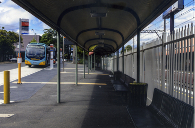 Whitehorse Historical Society Inc.
Photograph, Mitcham Railway Station
... Coloured photograph of a Venture bus pulling into the bus stop on the south side of Mitcham Railway Station.Behind the bus is a building which is the start of a large industrial estate that runs alongside the railway line to Rooks Road, Nunawading - 2012...Whitehorse Historical Society Inc. 2-10 Deep Creek Road Mitcham melbourne mitcham railway station transport Coloured photograph of a Venture bus pulling into the bus stop on the south side of Mitcham Railway Station.Behind the bus is a building which is the start of a large industrial estate that runs alongside the railway line to Rooks Road, Nunawading - 2012 Mitcham Railway Station Photograph Photograph ...Coloured photograph of a Venture bus pulling into the bus stop on the south side of Mitcham Railway Station.Behind the bus is a building which is the start of a large industrial estate that runs alongside the railway line to Rooks Road, Nunawading - 2012mitcham railway station, transport -
Glenelg Shire Council Cultural Collection
Photograph - Photograph - View of Portland and foreshore, 21/03/1972
... ... Industrial Estate...Henty park, industrial estate along Canal court. Facilities block, No.6 berth, silos and grain storage G.E.B. ...Henty park, industrial estate along Canal court. Facilities block, No.6 berth, silos and grain storage G.E.B. ...Port of Portland Authority archives.Front: (no inscriptions) Back: (no inscriptions)port of portland archives, portland harbour, henty park, industrial estate, canal court -
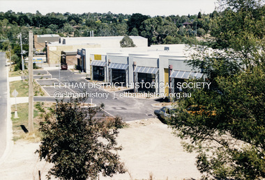 Eltham District Historical Society Inc
Photograph, Factories, Simms Road, Briar Hill, February 1990
... ...industrial estate...Industrial estate with new buildings...Industrial estate with new buildings briar hill simms road factories industry industrial estate Colour photo print (4) Factories, Simms Road, Briar Hill Photograph ...Industrial estate with new buildingsColour photo print (4)briar hill, simms road, factories, industry, industrial estate -
 Eltham District Historical Society Inc
Photograph, Main Road, Research
... ...research industrial estate...Three colour photographs showing Main Road, Research in the vicinity of Research Industrial Estate. 1. Looking north towards the Aqueduct 2. ...Eltham District Historical Society Inc 728 Main Rd Eltham melbourne main road research research industrial estate Three colour photographs showing Main Road, Research in the vicinity of Research Industrial Estate. 1. ...Three colour photographs showing Main Road, Research in the vicinity of Research Industrial Estate. 1. Looking north towards the Aqueduct 2. Looking north towards former road alignment 3. Looking north towards the Little Eltham Theatre 3.main road, research, research industrial estate -
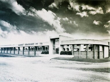 City of Ballarat Libraries
Photograph - Card Box Photographs, Simmonds Aerocessories Building, Ballarat circa 1960
... ...Guncotton Industrial Estate...This was part of the Guncotton Industrial Estate....This was part of the Guncotton Industrial Estate. Simmonds Aerocessories Pty Ltd Guncotton Industrial Estate Building Manufacturing Streetscape Latrobe Street Simmonds Aerocessories Building, Ballarat circa 1960. ...The Administration block for Simmonds Aerocessories Pty Ltd was located on Latrobe Street. This was part of the Guncotton Industrial Estate.simmonds aerocessories pty ltd, guncotton industrial estate, building, manufacturing, streetscape, latrobe street -
City of Kingston
Photograph - Black and white, 20 December 1945
... The visible market gardens, farms and paddocks have gradually been sub-divided into housing, commercial and industrial estates. ...The visible market gardens, farms and paddocks have gradually been sub-divided into housing, commercial and industrial estates. A large part of Cheltenham was originally established as a rural market gardening community. ...This photograph depicts a section of Cheltenham with a mix of housing and market gardens. The visible market gardens, farms and paddocks have gradually been sub-divided into housing, commercial and industrial estates. A large part of Cheltenham was originally established as a rural market gardening community. The railway line and station brought urban development to the area and the gradual subdivision of farmland and large land holdings for the development of housing. Aerial photograph dated 1945 of the Cheltenham area in the City of Kingston. Sydney Street (bottom left); Sinclair Street (top left); Weymar Street area off Wilson Street, Charles Street (botton right).White print VIC-170; 57197; RUN5; PROJ.No.5; MELB.METROP AREA Lens information [indecipherable] Small photograph: clockface Black ink: 57197cheltenham, market gardens, urbanisation -
 Hume City Civic Collection
Photograph, c1960s
... The photograph overlooks former railway land along Vineyard Road which is now a commercial and light industrial estate. It was taken before curbing and footpaths were laid and Vineyard Road was narrow strip of asphalt with the sides of the road unmade....Hume City Civic Collection 44 Macedon Street Sunbury melbourne The photograph overlooks former railway land along Vineyard Road which is now a commercial and light industrial estate. It was taken before curbing and footpaths were laid and Vineyard Road was narrow strip of asphalt with the sides of the road unmade. ...The photograph overlooks former railway land along Vineyard Road which is now a commercial and light industrial estate. It was taken before curbing and footpaths were laid and Vineyard Road was narrow strip of asphalt with the sides of the road unmade.A black and white photograph of Vineyard Road with the Sunbury Railway line visible across the middle distance and the former Sunbury Asylum site in the background.vineyard road, sunbury asylum, sunbury railway line, george evans collection -
City of Kingston
Photograph - Black and white, 5 January 1984
... The market gardens, farms and paddocks have gradually been sub-divided into housing and industrial estates and associated infrastructure such as schools and shopping facilities. ...The market gardens, farms and paddocks have gradually been sub-divided into housing and industrial estates and associated infrastructure such as schools and shopping facilities. ...Cheltenham and Heatherton are suburbs in the City of Kingston that were originally established as a rural market gardening community. The market gardens, farms and paddocks have gradually been sub-divided into housing and industrial estates and associated infrastructure such as schools and shopping facilities. This aerial image covers a diverse section of the City of Kingston, taking in the suburbs of Cheltenham, Heatherton, Mentone and Parkdale. By 1984, the market gardens of the district have been replaced by housing and factories. The Nylex factory is visible and now closed. Mentone Bowl on the corner of Warrigal Road and Nepean Highway has now been replaced by high rise apartments, another feature of the changing landscape in the City of Kingston. The vacant land now occupied by the Moorabbin Airport Direct factory Outlet (DFO) is also depicted.Aerial photograph of Cheltenham, Heatherton, Mentone and Parkdale within the City of Kingston. The area depicted in the 1984 aerial view includes Centre Dandenong Road and Cheltenham East Primary School (top left), Kingston Heath Reserve (top right), intersection of Lower Dandenong Road, Warrigal Road, Balcombe Road and Nepean Highway (bottom left), Balmoral Drive/McSwain Street Parkdale (bottom right).White text: 3831-179 Lens information [indecipherable] RINGWOOD M/S 7922-3 RUN 16 [Clockface image] 5,300' ASL VIC DLS© 5-1-84cheltenham, heatherton, mentone, parkdale, market gardens, urbanisation -
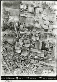 City of Kingston
Photograph - Black and white, 20 December 1945
... The market gardens, farms and paddocks have gradually been sub-divided into housing and industrial estates. The Southland shopping centre is a major feature of the area....The market gardens, farms and paddocks have gradually been sub-divided into housing and industrial estates. The Southland shopping centre is a major feature of the area. ...Cheltenham is a suburb in the City of Kingston that was originally established as a rural market gardening community. The area is bordered by Highett, Mentone and Heatherton. The market gardens, farms and paddocks have gradually been sub-divided into housing and industrial estates. The Southland shopping centre is a major feature of the area.Cheltenham was established as a rural market gardening community. The Le Page family lived in Cheltenham since 1854 when Nicholas Le Page, a tailor from the Channel Island of Guernsey, bought two acres of land on Chesterville Road near Bernard Street to establish a market garden. Over the years the Le Pages purchased more land in the area. In 1875-76 Nicholas' son Frank and his wife Mary built 'Daphne Cottage' near the corner of Bernard and Wilson Streets. n the 1940s Frank's son, Everest Le Page, bought five more lots of land in Chesterville Road from the Tuck family. The Le Pages grazed horses, ponies and cows on this land, and grew pumpkins, carrots, parsnips, onions, potatoes and cabbages. Many buildings and locations within in Cheltenham commemorate the Le Page family's contribution to the Cheltenham community.Aerial photograph taken in 1945 of the Cheltenham district within the City of Kingston. The image includes Chesterville Road, the future site of Turner Road pool (now Waves) and Highett Reserve, (top left), Jellicoe Street, Argus Street, Bernard Street, Wilson Street, the Methodist Children Homes (now Southland), McIvor Street, Goulburn Street, Nepean Highway, Jamieson Street and Barker Street (bottom left), market gardens and paddocks. In the top centre of the image, "Daphne Cottage", the home of Frank T. Le Page is visible on the corner of Bernard and Wilson Streets. Much of the land depicted in this image was owned by the Le Page family. This image is possibly from the collection of aerial photographs commissioned by the Department of Crown Lands and Survey and taken by Adastra Airways.Black and white ink: 57250 White print: VIC-170 57250 20.12.45 Run 6 PROJ. No. 5 MELB. METROP AREA Black type 10200 FTS 30' LENS 20.12.45cheltenham, market gardens, industry, le page family -
City of Kingston
Photograph - Black and white, 5 January 1984
... The market gardens, farms and paddocks have gradually been sub-divided into housing and industrial estates and associated infrastructure such as schools and shopping facilities. ...The market gardens, farms and paddocks have gradually been sub-divided into housing and industrial estates and associated infrastructure such as schools and shopping facilities. ...Moorabbin, Cheltenham and Highett are suburbs in the City of Kingston with a diverse mix of development and zoning. The market gardens, farms and paddocks have gradually been sub-divided into housing and industrial estates and associated infrastructure such as schools and shopping facilities. The area includes many parks, reserves and golf courses.This aerial image covers a diverse section of the City of Kingston, taking in the suburbs of Cheltenham, Moorabbin, Beaumaris and Highett. By 1984, the market gardens of the district have been replaced by housing and factories. The Gas and Fuel state-of-the-art Scientific Services Department is visible on Nepean Highway Highett. The CSIRO Highett site can also be seen. Both sites have now been demolished and have undergone remediation. The Southland site is visible and yet to be redeveloped by Westfield. This image portrays the diversity of development in the City of Kingston with a mixture of green spaces, housing and commercial and industrial features.Aerial photograph of Cheltenham, Beaumaris, Moorabbin and Highett within the City of Kingston. The area depicted in the 1984 aerial view includes Eden Street and Edward Street, Cheltenham (top left), Weatherall Road and Reserve Road, Cheltenham/Beaumaris (top right), Turner Road and Chesterville Road, Moorabbin (bottom left), Nepean Highway (left section), Graham Road and Middleton Street, Highett (bottom right). A large section of this image includes Cheltenham Park and Victoria Golf Club.White text: 3831-219 Lens information [indecipherable] RINGWOOD M/S 7922-3 RUN 15 Clockface image 5,300' ASL VIC DLS© 5-1-84cheltenham, highett, industrialisation, urbanisation, moorabbin, beaumaris -
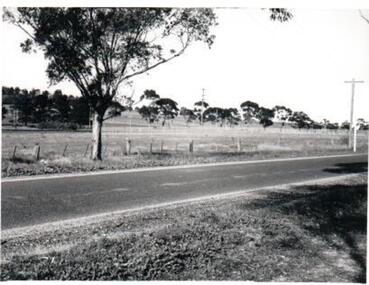
 Eltham District Historical Society Inc
Slide, Maroondah Aqueduct, Research, Victoria, 22 Mar. 1981
... This view shows the area that would develop into the Research Industrial Estate. In centre distance though largely hidden by trees is the site of the Research Hall, which was later demolished and a new Eltham Little Theatre constructed in 1988 as a bicentennial project. ...Eltham District Historical Society Inc 728 Main Rd Eltham melbourne This view shows the area that would develop into the Research Industrial Estate. In centre distance though largely hidden by trees is the site of the Research Hall, which was later demolished and a new Eltham Little Theatre constructed in 1988 as a bicentennial project. ...This view shows the area that would develop into the Research Industrial Estate. In centre distance though largely hidden by trees is the site of the Research Hall, which was later demolished and a new Eltham Little Theatre constructed in 1988 as a bicentennial project. The hills in the distance near the power lines now a housing estate.35 mm colour positive transparency (1 of 5) Mount - Agfachrome Agfa CS System black 8 dotsactivities, heritage excursion, maroondah aqueduct, research (vic.), shire of eltham historical society -
City of Kingston
Photograph - Black and white, 3 March 1954
... The market gardens, farms and paddocks have gradually been sub-divided into housing and industrial estates. Highett is developed with residential homes but was also the site of major facilities such as the Highett Gas Works. ...The market gardens, farms and paddocks have gradually been sub-divided into housing and industrial estates. Highett is developed with residential homes but was also the site of major facilities such as the Highett Gas Works. ...Cheltenham and Moorabbin are suburbs within the City of Kingston that were originally established as rural market gardening communities The area is bordered by Highett and Mentone. The market gardens, farms and paddocks have gradually been sub-divided into housing and industrial estates. Highett is developed with residential homes but was also the site of major facilities such as the Highett Gas Works. This aerial image covers a diverse section of the City of Kingston, taking in the suburbs of Moorabbin, Cheltenham, Highett and Mentone Residential housing development is prominent along the Frankston Railway line and the area still retains extensive market gardens and paddocks yet to be converted to a large industrial and commercial zone.Aerial photograph of Mentone, Cheltenham and Moorabbin within the City of Kingston. The area depicted in this 1954 aerial view includes Warrigal Road and Centre Dandenong Road intersection (top left); Charman Road, Patty Street, Bourke Street, Collins Street Mentone (top right); Keys Road Moorabbin (bottom left); Bay Road, Cheltenham (bottom right), Friendship Square, Cheltenham Park, Victoria Golf Club and Jack Barker Oval are visible. Nepean Highway and the Frankston railway line run centrally through the image. Highett Gasworks is also evident.White handwriting and type [indecipherable]. White image of clockface White image of compass White type 42956 Black handwriting 3/3/54 Williams [indecipherable] Black pencil: S [arrow] Black ink: 3/3/1954cheltenham, moorabbin, mentone, highett, market gardens -
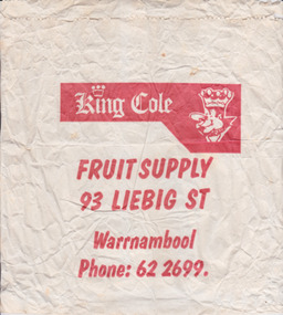 Warrnambool and District Historical Society Inc.
Functional object - Packaging: King Cole bag, Circa 1970
... The business name King Cole continues to have a link with Warrnambool as a wholesale business which operates from the industrial Estate in Cooper St West Warrnambool....The business name King Cole continues to have a link with Warrnambool as a wholesale business which operates from the industrial Estate in Cooper St West Warrnambool. ...King Cole’s fruit shop operated in Liebig Street from around the 1940’s. It was operated by Alan Cole and his family for many years. Many of the advertisements of the mid20th century are advertising case lots of locally sourced product such as Portland and Harcourt. The business name King Cole continues to have a link with Warrnambool as a wholesale business which operates from the industrial Estate in Cooper St West Warrnambool.This item provides an historical and social link with the people of Warrnambool and district.White paper bag with red printing.King Cole Fruit supply 93 Liebig St Warrnambool, Phone 622699.warrnambool, king cole, alan cole, fruiterer, liebig st -
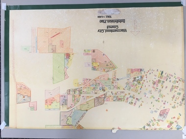 Warrnambool and District Historical Society Inc.
Map, Plans (5) showing Subdivisions of Warrnambool, 1989
... Plans two to five are almost intact and are bound with green tape. Plan Two- Industrial Estate of West Warrnambool; Plan Three – Hospital/Merrivale/ Lake Pertobe areas; Plan Four – North Warrnambool, Wollaston/Brierly areas; Plan Five – Flaxman Street area. ...Plans two to five are almost intact and are bound with green tape. Plan Two- Industrial Estate of West Warrnambool; Plan Three – Hospital/Merrivale/ Lake Pertobe areas; Plan Four – North Warrnambool, Wollaston/Brierly areas; Plan Five – Flaxman Street area. ...These plans have been drawn by Steve Hester for the Warrnambool City Council to illustrate the allotments in Warrnambool concerned with the subdivisions of 1989. The streets have not been named but there is an indication of the area with the identification of known buildings (eg Hospital) and the plan numbers of each allotment is clearly marked. These numbers corresponded to the plan numbers registered in card files and ledgers in the Warrnambool City Council offices. The scale of the plans was 1 to 5000. These plans are of considerable interest because they show Warrnambool street subdivisions of 1989 in illustrative form. They show how information was collated in the late 1980s before the widespread use of computer digital means to describe and store information.These are five hand-drawn sheets showing plans of sub-divisions in Warrnambool streets in 1989 (Warrnambool City Council material). The plans are multi-coloured (crayons) and show allotments with plan numbers. The first plan has much of the material torn off but the location is known to be in the Russells Creek area. Some of the green tape around the edges is missing. Plans two to five are almost intact and are bound with green tape. Plan Two- Industrial Estate of West Warrnambool; Plan Three – Hospital/Merrivale/ Lake Pertobe areas; Plan Four – North Warrnambool, Wollaston/Brierly areas; Plan Five – Flaxman Street area. ‘Subdivision Plan, Reference Guide, Steve Hester, Oct. 1989’. warrnambool street subdivisions, steve hester, history -
City of Kingston
Photograph - Black and white, 27 February 1964
... The previous market gardens, farms and paddocks have gradually been sub-divided into housing and industrial estates. The Methodist Children's Home Methodist Homes for Children and St John of God Training Centre on the site of the future Southland shopping centre has not yet been demolished. ...The previous market gardens, farms and paddocks have gradually been sub-divided into housing and industrial estates. The Methodist Children's Home Methodist Homes for Children and St John of God Training Centre on the site of the future Southland shopping centre has not yet been demolished. ...Cheltenham is a suburb in the City of Kingston that was originally established as a rural market gardening community. The area is bordered by Highett. The previous market gardens, farms and paddocks have gradually been sub-divided into housing and industrial estates. The Methodist Children's Home Methodist Homes for Children and St John of God Training Centre on the site of the future Southland shopping centre has not yet been demolished. The recently built Cheltenham High School is visible and the increased urbansation of the area is evident. Some farmland remains including the Le Page homestead.The developing urban area of Cheltenham within the City of Kingston. This image illustrates the mid-century urban sprawl of of Cheltenham and the subdivision of market gardens within the municipality and the changing demographic of the district as new houses are constructed and infrastructure established.Aerial photograph of the suburbs of Cheltenham and Highett within the City of Kingston. Highett Gas Works (top left); Bernard Street, Cheltenham (top right); Weatherall Road (bottom left): Elliott and Cobham Streets Cheltenham (bottom right).White handwritten: X Vic.1831 White type: MELBOURNE 1963 PROJECT RUN23 [underlined] 27-2-64 LENS 205 152-70 M/M 5.150 [arrow] White handwritten: X 166 cheltenham, highett, urbanisation -
Federation University Historical Collection
Booklet, N.L. Harvey Photographers, All that Glitters ... :The Growth of Ballarat Victoria, c1966
... ...Ballarat Industrial Estate...John, Sebastopol Technical School, reservoirs, Ballarat Base Hospital, Calembeen Park, Ballarat Industrial Estate, Lal Lal Falls, Buninyong Golf Course, Mayne Nickless, Firth Cleveland Plant, Bendix Mintex, Bunge, (Aust.) ...John, Sebastopol Technical School, reservoirs, Ballarat Base Hospital, Calembeen Park, Ballarat Industrial Estate, Lal Lal Falls, Buninyong Golf Course, Mayne Nickless, Firth Cleveland Plant, Bendix Mintex, Bunge, (Aust.) ...Red, blue and gold soft covered booklet. Images include the Ballarat Town Hall, The Eureka Monument, Begonia house, Ballarat Botanic Gardens,M.B. John, Sebastopol Technical School, reservoirs, Ballarat Base Hospital, Calembeen Park, Ballarat Industrial Estate, Lal Lal Falls, Buninyong Golf Course, Mayne Nickless, Firth Cleveland Plant, Bendix Mintex, Bunge, (Aust.) Pty Ltd, Martin's Stoneware, Sunshine biscuits, Timken, M.B. John and Hattersley Limited, Ballarat Gas Company, Ballarat Paper Mills, Ballarat Woollen and Worsted Mills, Eclipse Motors, E. Lucas and Co, Milk Processors Pty Ltd, Eureka Valves, Paddle Bros., George Farmer Pty Ltd, Sebastopol technical School, Burrumbeet and Windermere Co-Operative Society Ltd .greater ballarat association, develop victoria council, ballarat, begonia queens, yvonne arstall, carol penrose, wendy longmore, lal lal falls, ballarat town hall, the eureka monument, begonia house, ballarat botanic gardens, m.b. john, sebastopol technical school, reservoirs, ballarat base hospital, calembeen park, ballarat industrial estate, buninyong golf course, mayne nickless, firth cleveland plant, bendix mintex, bunge, martin's stoneware, sunshine biscuits, timken, m.b. john and hattersley limited, ballarat gas company, ballarat paper mills, ballarat woollen and worsted mills, eclipse motors, e. lucas and co, milk processors pty ltd, eureka valves, paddle bros., george farmer pty ltd, yvonne arsrtall, wendouree, shire of wendouree, guncotton factory, regina glass fibre -
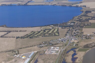 Lake Bolac & District Historical Society
Colour photograph, Aerial view of Lake Bolac and village. After the rain, 2010
... Note the edge of the salt-lake in the bottom right, the Industrial Estate bottom left and centre, the golf course, the current footy oval, Bowling Club, tennis courts and swimming pool with the P-12 College through the trees on the bank of the lake. ...Note the edge of the salt-lake in the bottom right, the Industrial Estate bottom left and centre, the golf course, the current footy oval, Bowling Club, tennis courts and swimming pool with the P-12 College through the trees on the bank of the lake. ...Aerial view of Lake Bolac after the drought had broken in late 2010. The fresh-water lake is now full, as are the wetlands. Note the edge of the salt-lake in the bottom right, the Industrial Estate bottom left and centre, the golf course, the current footy oval, Bowling Club, tennis courts and swimming pool with the P-12 College through the trees on the bank of the lake. An Archaeologist might be able to discern the original footy oval bottom centre, built on what was once the town Common (below the industrial buildings),and the second oval (above the salt lake.) The houses are spreading along the west bank of the lake beyond the school.lake bolac, 2010, village, fresh-water lake, salt lake, golf, tennis, bowling, swimming, college, -
 Glenelg Shire Council Cultural Collection
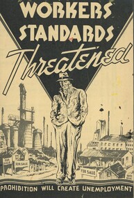
Ephemera - Pamphlet - Liquor Trades Defence Union of Australia, Liquor Trades Defence Union, Workers Standards Threatened, Early 1900s
... In the background is an industrial estate with what looks like factory chimneys. ...In the background is an industrial estate with what looks like factory chimneys. ...This pamphlet was produced by the Liquor Trades Defence Union. Mr John James Liston was secretary to the Union and appointed to this office in 1906. He directed many campaigns against prohibition. The Temperance movement began in Australia in the earl 1800s and advocated for moderation rather than abstinence. In response to this many hotels were converted to 'Coffee Palaces' in the late 1800s and did not serve any alcohol. During World War I early closing was introduced in many states including Victoria. This led to the advent of the 'six o'clock swill' where people would rush to drink as much as they could before closing. Unions such as the Liquor Trades Defence Union opposed this due to workers losing jobs and lost earnings.The pamphlet illustrates the history of temperance in Australia and the part that trade unions played in the fight against prohibition. Paper pamphlet. One piece of paper, folded to make 4 pages. The front page depicts a black triangle shape coming down from the top of the page with the point reaching down. At the top of the triangle are the words 'Workers Standards Threatened'. At the point of the triangle is a man in a rumpled suit and hat. His hands are in his pockets and he has a serious expressions. In the background is an industrial estate with what looks like factory chimneys. There are also small weatherboard houses with 'for sale' signs in front of them. Along the bottom of the page is a black wavy line with the words in off white ' 'prohibition will create unemployment'. The paper is off white/yellow with black text. Inside is a two page spread calling for union members to vote ' No'. The back page features rhetoric on what prohibition would mean to workers and talks of job displacement and lost earnings. The pamphlet is authorised by J. J. Liston, The Block, Collins St, C1. There are what appears to be paint marks on the pamphlet.temperance, prohibition, trades union, union, melbourne, glenelg shire council cultural collection, australian history, alcohol -
 Wodonga & District Historical Society Inc
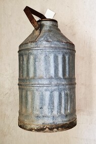
Functional object - ALBA Petrol Can, ALBA Petroleum Company, 1933 - 1945
... They had distribution facilities in the industrial estate of Newport in Victoria and also marketed to South Australia and Tasmania. ...They had distribution facilities in the industrial estate of Newport in Victoria and also marketed to South Australia and Tasmania. ...This artefact originates from a petroleum company which operated in Victoria from 1933 until 1945. The Alba Petroleum Company of Australia Pty. Ltd. was established by P. J. Adams and A.G. Wales. They had distribution facilities in the industrial estate of Newport in Victoria and also marketed to South Australia and Tasmania. Their advertising during World War 11 emphasised the need to keep petrol profits in Australia. They claimed to have the largest independent bulk storage unit in Australia. They pioneered the use of tar alcohol which was blended with "standard motor spirit to produce a super fuel. They were marketers of ALBA Super, the Aviation Quality Spirit containing Australian produced alcohol, ALBA motor spirit, ALBA power kerosene and ALBALITE lighting kerosene. In 1945 after the war ended, ALBA was incorporated with the Australian Motorists Petrol Company, which in turn, became AMPOL Petroleum Ltd in 1949.This artefact is representative of an Australian innovative company and a product which was widely used on a local, state and national level for industrial and domestic applications.A cylindrical steel/metal can for petrol storage and transfer. It has the brand name of the company ALBA embossed into the lid.On lid: " ALBA"alba petroleum company, ampol, petroleum companies australia -
Kew Historical Society Inc
Booklet - Old Kew Golf Links Estate, 1926
... Estate'. These sites had historic importance in Kew's history as they had previously belonged to Kodak Pty Ltd who were refused permission by Kew Council to use the land for industrial development. ...Estate'. These sites had historic importance in Kew's history as they had previously belonged to Kodak Pty Ltd who were refused permission by Kew Council to use the land for industrial development. ...Subdivision plans and real estate flyers/brochures reveal a number of aspects of urban development and history. The Kew Historical Society's collection of these plans, as well as advertisements extracted from magazines, cover key aspects of community development and architectural history of Kew and Kew Eat as well as surrounding suburbs. While most of the plans in the collection were gifted to the Society by the former City of Kew, a number of other plans and advertisements have been donated by individuals, of which this is an example.8-page brochure advertising 80 residential home sites for sale in a subdivision called the 'Old Kew Golf Links Estate'. These sites had historic importance in Kew's history as they had previously belonged to Kodak Pty Ltd who were refused permission by Kew Council to use the land for industrial development. The estate, advertised was advertised as being within five miles of Melbourne. The brochure is notable as it includes photographs of Kew East Primary School, the former Kew Golf Club clubhouse, and 'The Moorings' Boathouse (aka Chipperfield's Boat House). The aerial photograph, overlaid with names of notable sites, on the final page is of interest as it shows the area before the intrusion of the Eastern Freeway, which resulted in changing the course of a section of the Yarra River. old kew golf links estate, subdivision -- kew (vic.), subdivisions -- kew east (vic), chipperfield's boathouse, kew east primary school, kew golf club -
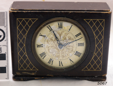 Flagstaff Hill Maritime Museum and Village
Clock, 1950
... Westclox had a highly successful factory in Scotland situated in the Vale of Leven Industrial Estate, in Dumbarton, around twenty miles from the City of Glasgow. ...Vale of Leven Industrial Estate, Dumbarton , Scotland, England, UK...Flagstaff Hill Maritime Museum and Village 89 Merri Street Warrnambool great-ocean-road Westclox had a highly successful factory in Scotland situated in the Vale of Leven Industrial Estate, in Dumbarton, around twenty miles from the City of Glasgow. ...Westclox had a highly successful factory in Scotland situated in the Vale of Leven Industrial Estate, in Dumbarton, around twenty miles from the City of Glasgow. Westclox had originally planned to start production in Scotland in 1939 but the War intervened and it was not until 1948 that they were able to fully commission their factory in Dumbarton. Westclox Scotland produced its first clock on the 21st September 1948; a spring wound alarm with a 4 inch dial. The Westclox factory in Scotland was a full manufacturing plant with all their clocks assembled from start to finish with only the basic raw materials being brought in by outside suppliers. 95% of the staff were local people and the firm trained their employees from scratch to a high level of skill and had an annual apprenticeship for toolmakers and classes in horology. By 1949 Westclox Scotland were making 10,000 clocks a week, and by 1950, 1,000,000 clocks had been produced since its opening. No home in the Dunbartonshire Vale was without at least one Westclox clock, nor any raffle complete without a clock as one of the prizes! Many of these clocks are still around today. So successful was the Dumbarton factory that in the mid 1950’s Westclox had to expand into adjoining buildings. The factory then added watches to what they made as well as timing devices for other sectors. By the mid 1960’s, employment levels at the Scottish plant were around 1100. Over a third of the clocks manufactured in Scotland were exported to some 110 countries across the globe. Difficult times came in 1967/68 when 400 workers were laid off and the future of the plant was in doubt primarily due to cheap clocks from the then communist countries. However, strong petitions to the UK Government produced the passing of an anti-dumping law allowed production from the factory to pick up. In 1968 General Time was bought out by Talley Industries, which was best known as a manufacturer of timing equipment, such as factory time clocks to various industries. Westclox in Scotland enjoyed several boom years under the then Managing Director, John Santos. Westclox Scotland in October 1974 hosted a Space Seminar for the Astronaut, Neil Armstrong and British Astronomer, Sir Patrick Moore. Both visited the Scottish factory to promote the introduction of Quartz time-keeping. In 1976 the Westclox plant in Dumbarton became the Headquarters of General Time (International Operations) Ltd. John Santos retired from General Time and Westclox in the early 1980s and by 1988 the future of Westclox in Scotland was almost over. The advent of Quartz clock technology, developed largely by General Time for use in the Apollo 11 Command Module, resulted in the reduction of mechanical clock production and sales, and the factory fully closed in 1988.The Westclox factory building in Dumbarton has been converted and is now home to many thriving small businesses. The item marks a time when clock production in the United Kingdom was at it’s peak producing clocks for sale in over a 110 countries, they were keenly priced and available to all. The company had many innervation's during it’s life regards clock and later wrist watch making. In 25 years the factory had produced over 50 million clocks, yet it was perhaps inevitable with the advent of Quartz technology that was ironically evolved, largely by General Time for use in the Apollo 11 Command space Module, that would ultimately herald the end of the mechanical clock.Wooden bedroom alarm clock small painted brown with a criss cross pattern in gold and a white enamel face roman numerals & a glass front, clock case is of a fancy design. Inscribed on face "Made by Westclox Ltd Scotland" .flagstaff hill, warrnambool, shipwrecked-coast, flagstaff-hill, flagstaff-hill-maritime-museum, maritime-museum, shipwreck-coast, flagstaff-hill-maritime-village, clock mantle, clock, mantle clock, westclox ltd, horology, clock industries -
 Warrnambool and District Historical Society Inc.
Document - Warrnambool City Council Preliminary Report Industrial Estate West Warrnambool, E Johnson, 9 March 1973
... Warrnambool City Council Preliminary Report Industrial Estate West Warrnambool......industrial estate...Document Warrnambool City Council Preliminary Report Industrial Estate West Warrnambool E Johnson ...This preliminary report relates to 32½ acres of council owned land in West Warrnambool bounded on the North by McMeekin Road, on the East by Scott Street, on the South by Evans Street and on the West by the rear boundaries of properties facing Landmann and Granter Streets. In 2010, West Warrnambool was the largest of Warrnambool’s existing industrial areas, comprising approximately 109ha of industrial zoned land, the majority of which (101ha) is zoned IN1Z, with the remainder zoned INZ3. The area comprises a mixture of lot sizes supporting a diverse mix of industries. Larger parcels are occupied by the abattoirs, scrap metal industries, freight, the Council Depot and storage. Smaller lots are occupied by smaller manufacturers and wholesalers and service industries. [Ref: Warrnambool Industrial Land Use Review. Mesh Pty Ltd July 2010]This document is a preliminary report prepared by the Warrnambool City Council Engineer in March 1973 and provides an example of the planning process undertaken to develop one of Warrnambool's industrial areas. It contains details and costings of the proposed subdivision. Two foolscaps size pages of typewritten information. A detailed topographical map of the area with areas highlighted in blue, red, green, blue and purple pen.warrnambool city council, west warrnambool, industrial estate