Showing 5658 items matching "melbourne and suburbs"
-
 Port Melbourne Historical & Preservation Society
Document - CD-ROM, Archive Digital Books Australia, Melbourne & Suburbs Street Directory 1936, 2011
... Melbourne & Suburbs Street Directory 1936..."Melbourne & Suburbs Street Directory 1936" Plastic CD case with white and pale green insert. ...Melbourne & Suburbs Street Directory 1936. Collins...Port Melbourne Historical & Preservation Society Port Melbourne Town Hall 333 Bay Street Port Melbourne melbourne engineering - roads streets lanes and footpaths 1936 street directory Melbourne & Suburbs Street Directory 1936. ..."Melbourne & Suburbs Street Directory 1936" Plastic CD case with white and pale green insert. Policeman image and motorcar.Melbourne & Suburbs Street Directory 1936. Collinsengineering - roads streets lanes and footpaths, 1936, street directory -
 Hume City Civic Collection
Manual - Street Directory, Morgan's Official Street Directory of Melbourne and Suburbs, 1980's
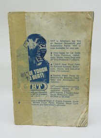
... Morgan's Official Street Directory of Melbourne and Suburbs...This street directory of Melbourne and Suburbs was the 52nd edition published by Val Morgan. ...A Morgan's street directory of Melbourne and Suburbs without a front cover....Hume City Civic Collection 44 Macedon Street Sunbury melbourne This street directory of Melbourne and Suburbs was the 52nd edition published by Val Morgan. ...This street directory of Melbourne and Suburbs was the 52nd edition published by Val Morgan. It is printed with a new map format.A Morgan's street directory of Melbourne and Suburbs without a front cover.morgan, val and co., melbourne, directories, street directories, george evans collection -
 Kew Historical Society Inc
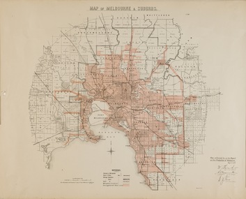
Map, Department of Lands & Survey, Map of Melbourne & Suburbs, 1899
... Map of Melbourne & Suburbs...The Metropolitan Fire Brigades Board commenced service on 1 May 1891. Melbourne and its surrounding suburbs were divided into 5 sub districts each with a district superintendent and paid firefighters with additional support from paid auxiliaries. ..."MAP OF MELBOURNE & SUBURBS / Plan referred to in the Report on Fire Protection in Melbourne, May 6th 1899 / Scale 80 Chains to 1 inch / Photo-lithographed at the Department of Lands and Survey Melbourne by T.F. ...Map of Melbourne & Suburbs Map Department of Lands & Survey ...The Metropolitan Fire Brigades Board commenced service on 1 May 1891. Melbourne and its surrounding suburbs were divided into 5 sub districts each with a district superintendent and paid firefighters with additional support from paid auxiliaries. This map was produced on 6 May 1899 by the Department of Lands & Survey Melbourne showing the distribution of water in Melbourne for use by fire brigades. While by 1910, there were 123,227 connections to Melbourne's water supply system, it is unclear in this 1899 map whether water was supplied to all built structures in the defined areas or only to fire hydrants and stand pipes.Map accompanying report on fire protection of Melbourne showing those areas with water supplies tinted."MAP OF MELBOURNE & SUBURBS / Plan referred to in the Report on Fire Protection in Melbourne, May 6th 1899 / Scale 80 Chains to 1 inch / Photo-lithographed at the Department of Lands and Survey Melbourne by T.F. McGauran, 1891" / May 1899 No.76"water reticulation -- melbourne (vic.), department of lands & survey -- historic maps, fire brigades -- melbourne (vic.), cartography -
Whitehorse Historical Society Inc.
Map, Sands and McDougall's Map of Melbourne & Suburbs, 1950s
... Sands and McDougall's Map of Melbourne & Suburbs...Wall map of Melbourne and suburbs 12-18 mile radius of CBD....Whitehorse Historical Society Inc. 2-10 Deep Creek Road Mitcham melbourne Melbourne Maps Wall map of Melbourne and suburbs 12-18 mile radius of CBD. ...Wall map of Melbourne and suburbs 12-18 mile radius of CBD.Wall map of Melbourne and suburbs 12-18 mile radius of CBD.Wall map of Melbourne and suburbs 12-18 mile radius of CBD.melbourne, maps -
 Ringwood and District Historical Society
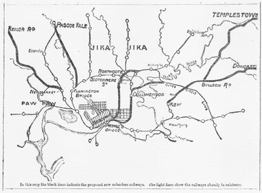
Document, Map of Melbourne suburbs showing proposed new railway lines - 1890
... Map of Melbourne suburbs showing proposed new railway lines - 1890...Black and white hand drawn map of Melbourne and some inner suburbs....Black and white hand drawn map of Melbourne and some inner suburbs. Map of Melbourne suburbs showing proposed new railway lines - 1890 Document ...Black and white hand drawn map of Melbourne and some inner suburbs.Typed at bottom of map: "In this map the black lines indicate the proposed new suburban railways. The light lines show the railways already in existence." -
Whitehorse Historical Society Inc.
Map, Map of East and South eastern suburbs of Melbourne, 1930s
... Map of East and South eastern suburbs of Melbourne...Map of suburbs of Melbourne from Kew to Ringwood and South Morang Station to East Oakleigh....Map of East and South eastern suburbs of Melbourne Map Map ...Map of suburbs of Melbourne from Kew to Ringwood and South Morang Station to East Oakleigh.Map of suburbs of Melbourne from Kew to Ringwood and South Morang Station to East Oakleigh.Map of suburbs of Melbourne from Kew to Ringwood and South Morang Station to East Oakleigh.blackburn, mitcham, hawthorn, box hill, doncaster, templestowe -
Whitehorse Historical Society Inc.
Map, Melbourne and suburbs, 1923
... Melbourne and suburbs...Section of map 'Melbourne and Suburbs' compiled at the Department of Lands and Survey, Melbourne by E. ...Whitehorse Historical Society Inc. 2-10 Deep Creek Road Mitcham melbourne Department of Lands and Surve Melbourne and Suburbs Section of map 'Melbourne and Suburbs' compiled at the Department of Lands and Survey, Melbourne by E. ...Section of map 'Melbourne and Suburbs' compiled at the Department of Lands and Survey, Melbourne by E. S. Hilcke, March 1923, reprinted 1940.Section of map 'Melbourne and Suburbs' compiled at the Department of Lands and Survey, Melbourne by E. S. Hilcke, March 1923, reprinted 1940. Scale 40 chains: 1 inch. - Shire of Blackburn and MitchamSection of map 'Melbourne and Suburbs' compiled at the Department of Lands and Survey, Melbourne by E. S. Hilcke, March 1923, reprinted 1940.department of lands and surve, melbourne and suburbs -
 City of Moorabbin Historical Society (Operating the Box Cottage Museum)
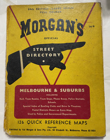
Book, Val Morgan & Sons, Morgan's Street Directory - Melbourne & Suburbs, 1960
... Morgan's Street Directory - Melbourne & Suburbs ...Melbourne...Melbourne & suburbs. Morgan's official street directory of Melbourne & suburbs Morgan's Street Directory - Melbourne & Suburbs Book Val Morgan & Sons ...Official street directory. Melbourne & suburbs. Morgan's official street directory of Melbourne & suburbsOfficial street directory. Melbourne & suburbs. Morgan's official street directory of Melbourne & suburbsmelbourne, suburbs, street directory -
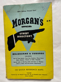 City of Moorabbin Historical Society (Operating the Box Cottage Museum)
Book, Val Morgan & Sons, Morgan's Street Directory - Melbourne & Suburbs, 1960's
... Morgan's Street Directory - Melbourne & Suburbs ...Melbourne...Melbourne & suburbs. Morgan's official street directory of Melbourne & suburbs Pocket size - 130 Reference maps Morgan's Street Directory - Melbourne & Suburbs Book Val Morgan & Sons ...Official street directory. Melbourne & suburbs. Morgan's official street directory of Melbourne & suburbsPocket size - 130 Reference mapsOfficial street directory. Melbourne & suburbs. Morgan's official street directory of Melbourne & suburbsmelbourne, suburbs, street directory -
 Melbourne Tram Museum
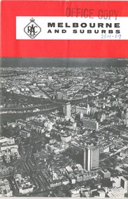
Map, Royal Automobile club of Victoria (RACv), "Melbourne and Suburbs", late 1960's
... "Melbourne and Suburbs"...Map - folded 8 folds or sections, printed in two colours titled "Melbourne and Suburbs", published by the RACV late 1960's, giving a map of Melbourne and its suburbs, shows all tram and rail lines, highways, freeways under construction, has a detailed index and map of the city or CBD area, shows one way streets and churches, clubs etc...."Melbourne and Suburbs" Map Royal Automobile club of Victoria (RACv) ...Map - folded 8 folds or sections, printed in two colours titled "Melbourne and Suburbs", published by the RACV late 1960's, giving a map of Melbourne and its suburbs, shows all tram and rail lines, highways, freeways under construction, has a detailed index and map of the city or CBD area, shows one way streets and churches, clubs etc.On front cover stamped "Office Copy" and hand written date of "28-1-69"trams, tramways, racv, melbourne, map, tramways, timetables -
 Melbourne Tram Museum
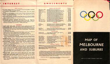
Map, Victorian Government Tourist Bureau, "Map of Melbourne and Suburbs", Jul. 1956
... "Map of Melbourne and Suburbs"...Map - .folded 12 sections full colour titled "Map of Melbourne and Suburbs". Issued at the time of the Melbourne Olympics by the Victorian Government Tourist Bureau. ...Melbourne Tram Museum 8 Wallen Road Hawthorn melbourne Trams tramways Map Olympics Public Transport Melbourne Map - .folded 12 sections full colour titled "Map of Melbourne and Suburbs". ...Map - .folded 12 sections full colour titled "Map of Melbourne and Suburbs". Issued at the time of the Melbourne Olympics by the Victorian Government Tourist Bureau. Has an index of Melbourne's suburbs, transport links, Places of Interest, Amusements, Facts of interest about Victoria. Major map shows the rail and tram lines, the detailed map of the CBD shows the buildings or locations referenced in the Tourist Guide to the City. Printed by the Victorian Railways - 2133-56trams, tramways, map, olympics, public transport, melbourne -
 Melbourne Tram Museum
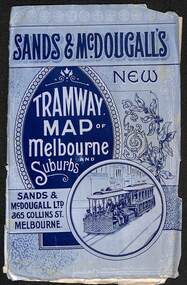
Map, Sands McDougall, "Tramway Map of Melbourne and Suburbs", c1906
... "Tramway Map of Melbourne and Suburbs"...Map - folded sheet of paper 5 sections wide x 4 sections or folds deep contained within a light grey paper cover titled "Tramway Map of Melbourne and Suburbs"...Yields information about Melbourne c1906 and its public transport lines. maps melbourne cable trams tramways railways horse trams NMETL VR Trams sands Mcdougall Map - folded sheet of paper 5 sections wide x 4 sections or folds deep contained within a light grey paper cover titled "Tramway Map of Melbourne and Suburbs" "Tramway Map of Melbourne and Suburbs" Map Sands McDougall ...Shows railways, cable and electric tram lines c1906. One of a number of maps produced by Sands McDougall of Collins St. Includes the MTOCo horse tram lines and the Caulfield horse tram lines. See items 2885 and 6573 for other editions. Yields information about Melbourne c1906 and its public transport lines. Map - folded sheet of paper 5 sections wide x 4 sections or folds deep contained within a light grey paper cover titled "Tramway Map of Melbourne and Suburbs"maps, melbourne, cable trams, tramways, railways, horse trams, nmetl, vr trams, sands mcdougall -
 Kew Historical Society Inc
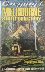
Book, Gregory's Publishing Company Pty Ltd, Gregory's Street Directory of Melbourne and suburbs and Metropolitan Road Guide, 1971
... Gregory's Street Directory of Melbourne and suburbs and Metropolitan Road Guide...Revised edition of Gregory's Directory including a series of road maps of Melbourne and its suburbs, newly extending to Lilydale, Mornington, Laverton, Deer Park, Epping, Diamond Creek, Olinda, Belgrave, and Doveton....Gregory's Street Directory of Melbourne and suburbs and Metropolitan Road Guide Book Gregory's Publishing Company Pty Ltd ...Street DirectoryRevised edition of Gregory's Directory including a series of road maps of Melbourne and its suburbs, newly extending to Lilydale, Mornington, Laverton, Deer Park, Epping, Diamond Creek, Olinda, Belgrave, and Doveton.non-fictionStreet Directorystreet directories - melbourne, gregory's street directories -
 Eltham District Historical Society Inc
Book, Gregory's Melbourne Street Directory of Melbourne and suburbs and metropolitan road guide (8th edition) extends to Laverton, Deer Park, Epping, Diamond Creek, Lilydale, Olinda, Belgrave, Doveton and Mornington, 1973
... Gregory's Melbourne Street Directory of Melbourne and suburbs and metropolitan road guide (8th edition) extends to Laverton, Deer Park, Epping, Diamond Creek, Lilydale, Olinda, Belgrave, Doveton and Mornington...It is a comprehensive guide to the streets and localities of Melbourne and suburbs at that time. The colour maps are arranged in double-page spreads. ...It is a comprehensive guide to the streets and localities of Melbourne and suburbs at that time. The colour maps are arranged in double-page spreads. ...This is the 8th edition of Gregory's Melbourne Street Directory, fully revised and up-to-date for this edition published December 1973. It is a comprehensive guide to the streets and localities of Melbourne and suburbs at that time. The colour maps are arranged in double-page spreads. Names of streets and suburbs are arranged alphabetically in the index to streets.Hard copy with plastic cover. 382 p. streets, melbourne - maps, roads -
 Sunshine and District Historical Society Incorporated
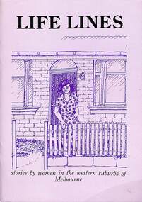
Book - Life Lines - stories by women in the Western Suburbs of Melbourne, Melbourne's Living Museum of the West et al
... Life Lines - stories by women in the Western Suburbs of Melbourne...Life Lines - stories by women in the Western Suburbs of Melbourne|Margaret Camilleri|Lesley Purcell|Josie Valente|Judy Grant|January Hope|Presented to the Sunshine International Women's Committee...Women Life Lines - stories by women in the Western Suburbs of Melbourne|Margaret Camilleri|Lesley Purcell|Josie Valente|Judy Grant|January Hope|Presented to the Sunshine International Women's Committee Book Life Lines - stories by women in the Western Suburbs of Melbourne Book Life Lines - stories by women in the Western Suburbs of Melbourne Melbourne's Living Museum of the West Robyn Hollander Rosey MacDonald Margaret Jacobs ...Bookwomen -
 Melbourne Tram Museum
Map, Sands McDougall, Map of Melbourne and Suburbs showing Tramways, Railways, Streets, postal districts, Quarter-Mile Radii etc", c1919
... Map of Melbourne and Suburbs showing Tramways, Railways, Streets, postal districts, Quarter-Mile Radii etc"... Produced by Sands and McDougall Pty Ltd of Collins St Melbourne. folded sheet of paper 6 sections wide x 6 sections or folds deep contained within a brown paper cover titled "Map of Melbourne and Suburbs showing Tramways, Railways, Streets, postal districts, Quarter-Mile Radii etc", showing both cable and electric tramways. ...Map of Melbourne and Suburbs showing Tramways, Railways, Streets, postal districts, Quarter-Mile Radii etc" Map Sands McDougall ...Shows railways, cable and electric tram lines c1919. One of a number of maps produced by Sands McDougall of Collins St. Includes the MTOCo zoo horse tram lines, the PMTT, HTT and MBCTT lines, but not the FNPTT or the FTT lines. See items 2885 and 6573 for other editions. Yields information about Melbourne c1919 and its public transport lines. Produced by Sands and McDougall Pty Ltd of Collins St Melbourne. folded sheet of paper 6 sections wide x 6 sections or folds deep contained within a brown paper cover titled "Map of Melbourne and Suburbs showing Tramways, Railways, Streets, postal districts, Quarter-Mile Radii etc", showing both cable and electric tramways. maps, melbourne, cable trams, tramways, railways, horse trams, nmetl, vr trams, sands mcdougall, mbctt, pmtt, htt, zoo horse tramway -
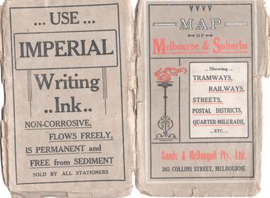
 Melbourne Tram Museum
Map, Sands McDougall, Map of Melbourne and Suburbs showing Tramways, Railways, Streets, postal districts, Quarter-Mile Radii etc", c1922
... Map of Melbourne and Suburbs showing Tramways, Railways, Streets, postal districts, Quarter-Mile Radii etc"... Produced by Sands and McDougall Pty Ltd of Collins St Melbourne. Folded sheet of paper 6 sections wide x 6 sections or folds deep contained within a green paper cover titled "Map of Melbourne and Suburbs showing Tramways, Railways, Streets, postal districts, Quarter-Mile Radii etc", showing both cable and electric tramways. ...Map of Melbourne and Suburbs showing Tramways, Railways, Streets, postal districts, Quarter-Mile Radii etc" Map Sands McDougall ...Shows railways, cable and electric tram lines c1922. One of a number of maps produced by Sands McDougall of Collins St. Includes the Zoo horse tram lines. See acquisition and Research note by Duncan McAuslan. See items 2885, 6573, amd 6917 for other editions. On inside cover has current postal rates (including a war surcharge) and places worth visiting and on the rear cover, is an advertisement for Imperial ink.Yields information about Melbourne c1922 and its public transport lines. Produced by Sands and McDougall Pty Ltd of Collins St Melbourne. Folded sheet of paper 6 sections wide x 6 sections or folds deep contained within a green paper cover titled "Map of Melbourne and Suburbs showing Tramways, Railways, Streets, postal districts, Quarter-Mile Radii etc", showing both cable and electric tramways. maps, melbourne, cable trams, tramways, railways, horse trams, vr trams, sands mcdougall, zoo horse tramway, mmtb -
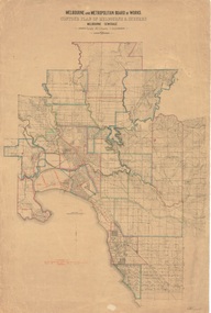 Kew Historical Society Inc
Plan, Melbourne & Metropolitan Board of Works : Contour Plan of Melbourne & Suburbs : Melbourne Sewage, 1894
... Melbourne & Metropolitan Board of Works : Contour Plan of Melbourne & Suburbs : Melbourne Sewage...Suburbs are outlined in coloured ink. Red lines indicate main and branch sewers in existence at the beginning of 1894 in central and inner Melbourne. ...Suburbs are outlined in coloured ink. Red lines indicate main and branch sewers in existence at the beginning of 1894 in central and inner Melbourne. ...The Melbourne and Metropolitan Board of Works (MMBW) plans were produced from the 1890s to the 1950s. They were crucial to the design and development of Melbourne's sewerage and drainage system. This plan forms part of a large group of MMBW plans and maps that was donated to the Society by the Mr Poulter, City Engineer of the City of Kew in 1989. Within this collection, thirty-five hand-coloured plans, backed with linen, are of statewide significance as they include annotations that provide details of construction materials used in buildings in the first decade of the 20th century as well as additional information about land ownership and usage. The copies in the Public Record Office Victoria and the State Library of Victoria are monochrome versions which do not denote building materials so that the maps in this collection are invaluable and unique tools for researchers and heritage consultants. A number of the plans are not held in the collection of the State Library of Victoria so they have the additional attribute of rarity.Digital copy of an original MMBW plan. This contour plan shows the area identified by the MMBW for purposes of drainage and sewerage in 1894. The suburbs represented extend from Williamstown in the west to Bulleen in the east, and from Preston in the north, south to Sandringham. Suburbs are outlined in coloured ink. Red lines indicate main and branch sewers in existence at the beginning of 1894 in central and inner Melbourne. These extended as far as Williamstown and Brighton, but not yet as far as Kew, where sewering did not commence until 1901. Contour lines show the topography, which was important for indicating the fall of the land for the laying of sewers and drainage channels. Kew appears to be fairly undeveloped at this date except for railway lines and stations (the Kew and Outer Circle lines), main roads, the Kew Lunatic Asylum Reserve and Studley Park. However, the contour plan does not accurately represent the density of settlement, nor the large number of houses, which were being built in Kew and other suburbs from the 1850s to the land boom of the late 1880’s and early 1890’s. This plan is part of a large and historically significant group of MMBW plans and maps that was donated to the Society by the Mr Poulter, City Engineer of the City of Kew in 1989.mmbw contour plan of melbourne and suburbs, melbourne and metropolitan board of works, melbourne sewage, cartography -
 Greensborough Historical Society
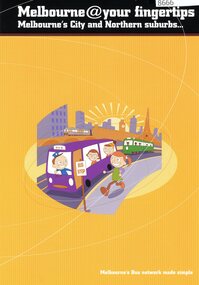
Pamphlet, Bus Association Victoria, Melbourne @ your fingertips: Melbourne's city and Northern suburbs, 2010s
... Melbourne @ your fingertips: Melbourne's city and Northern suburbs...An explanation of Melbourne's bus network in the city and Northern suburbs....Melbourne @ your fingertips: Melbourne's city and Northern suburbs Pamphlet Pamphlet Bus Association Victoria ...An explanation of Melbourne's bus network in the city and Northern suburbs.Colour leaflet, double-sided, 6 p., map.public transport, buses -
 Ringwood and District Historical Society
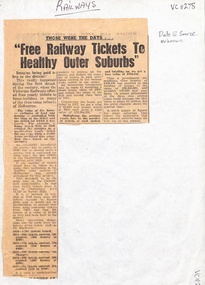
Newspaper, Free Railway Tickets to healthy Melbourne Outer Suburbs - article about tickets in the early 1900's - Newspaper article, date and source unknown
... Free Railway Tickets to healthy Melbourne Outer Suburbs - article about tickets in the early 1900's - Newspaper article, date and source unknown, ...Newspaper article on free yearly tickets, offered "during the first decade of the century" to home builders in many of the then outer suburbs of Melbourne - Camberwell, Surrey Hills, Canterbury. ...Ringwood and District Historical Society 125A Warrandyte Road Ringwood North melbourne Newspaper article on free yearly tickets, offered "during the first decade of the century" to home builders in many of the then outer suburbs of Melbourne - Camberwell, Surrey Hills, Canterbury. ...Newspaper article on free yearly tickets, offered "during the first decade of the century" to home builders in many of the then outer suburbs of Melbourne - Camberwell, Surrey Hills, Canterbury. According to calculations in the article, free tickets costing the government £438,450 resulted in the building of houses to the value of £38,300.000 and probably 130,000 new residences. -
 Melbourne Tram Museum
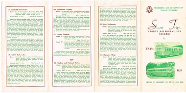
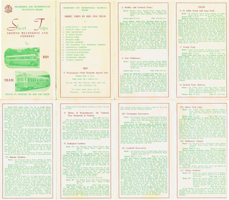
Pamphlet, Melbourne & Metropolitan Tramways Board (MMTB), "Short Trips around Melbourne and Suburbs by Tram and Bus", late 1950's
... "Short Trips around Melbourne and Suburbs by Tram and Bus"...Pamphlet titled "Short Trips around Melbourne and Suburbs by Tram and Bus", two colour printed document folded into 4 on buff coloured paper, featuring 14 various trips around Melbourne, with a detailed description of each route, time, fare and notes. ..."Short Trips around Melbourne and Suburbs by Tram and Bus" Pamphlet Melbourne & Metropolitan Tramways Board (MMTB) ...Pamphlet titled "Short Trips around Melbourne and Suburbs by Tram and Bus", two colour printed document folded into 4 on buff coloured paper, featuring 14 various trips around Melbourne, with a detailed description of each route, time, fare and notes. Probably late 1950's given that it has a suggested tour of the Olympic Village. 2 copies held. See also Reg Item 343 for a later version.trams, tramways, mmtb, tourist trips, fares -
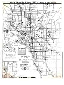 Melbourne Tram Museum
Map, Gawler and Drummond Architects, "Railway and Tramway Map of Melbourne and Suburbs", 1920's?
... "Railway and Tramway Map of Melbourne and Suburbs"...Map - photocopy - titled "Railway and Tramway Map of Melbourne and Suburbs", c1920 showing railways, cable, electric tramways and authorised electric additions. ...Melbourne Tram Museum 8 Wallen Road Hawthorn melbourne Trams tramways Map Footscray St Kilda New Tramway Melbourne Tourism Map - photocopy - titled "Railway and Tramway Map of Melbourne and Suburbs", c1920 showing railways, cable, electric tramways and authorised electric additions. ...Map - photocopy - titled "Railway and Tramway Map of Melbourne and Suburbs", c1920 showing railways, cable, electric tramways and authorised electric additions. Shows the South Melbourne St Kilda tram line and some lines in the Footscray area as dotted. Prepared by Gawler and Drummond Architects. Has an advertisement for "Rolfes" tea along the top edge and "See Victoria First" - Government Tourist Office, corner of Swanston and Collins St.trams, tramways, map, footscray, st kilda, new tramway, melbourne, tourism -
 Melbourne Tram Museum
Map, Sands and McDougall Pty Ltd, "Map of Melbourne and Suburbs showing Tramways, Railways, Streets, postal districts, Quarter-Mile Radii etc", c1930
... "Map of Melbourne and Suburbs showing Tramways, Railways, Streets, postal districts, Quarter-Mile Radii etc"...Produced by Sands and McDougall Pty Ltd of Collins St Melbourne. Map - folded sheet of paper 5 sections wide x 6 sections or folds deep contained within a dark grey paper cover titled "Map of Melbourne and Suburbs showing Tramways, Railways, Streets, postal districts, Quarter-Mile Radii etc", showing both cable and electric tramways. verted, but not Market St to Port Melbourne or South Melbourne. ..."Map of Melbourne and Suburbs showing Tramways, Railways, Streets, postal districts, Quarter-Mile Radii etc" Map Sands and McDougall Pty Ltd ...Produced by Sands and McDougall Pty Ltd of Collins St Melbourne. Map - folded sheet of paper 5 sections wide x 6 sections or folds deep contained within a dark grey paper cover titled "Map of Melbourne and Suburbs showing Tramways, Railways, Streets, postal districts, Quarter-Mile Radii etc", showing both cable and electric tramways. verted, but not Market St to Port Melbourne or South Melbourne. Shows the Collins St line being constructed. Collins St routes were opened late 1929, map produced during the early 1930's prior to the closure of Market St - Port Melbourne. Has a detailed list of the postal districts.trams, tramways, maps, melbourne, cable trams, tramways, railways -
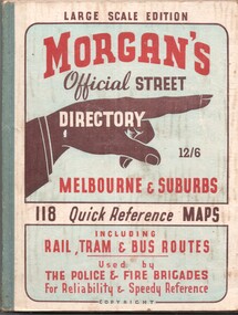 Melbourne Tram Museum
Book, The Met, "Morgan's Official Street Directory - Melbourne and Suburbs", c1951
... "Morgan's Official Street Directory - Melbourne and Suburbs"...Book - 5 sections, sewn with green cloth spine binding, card covers, 188 pages, 118 maps, titled "Morgans Official Street Directory - Melbourne and Suburbs" Has many advertisements around edges of the maps. ..."Morgan's Official Street Directory - Melbourne and Suburbs" Book The Met ...Book - 5 sections, sewn with green cloth spine binding, card covers, 188 pages, 118 maps, titled "Morgans Official Street Directory - Melbourne and Suburbs" Has many advertisements around edges of the maps. Shows the Latrobe St line (opened 1/1951), but not the Bourke St tram line. Price 12/6. Published by Val Morgan and Sons of 64 Elizabeth St Melbourne. A web search for similar directories - Museum of Victoria - https://collections.museumsvictoria.com.au/items/1217271 gives background to the directory.trams, tramways, maps, melbourne, street directory -
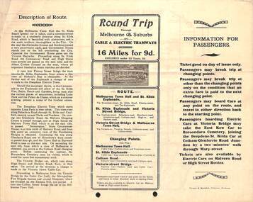 Melbourne Tram Museum
Pamphlet, Prahran & Malvern Tramway Trust (PMTT), "Information for passengers - Round trip through Melbourne and Suburbs by Cable and Electric Tramways", c1918/19
... "Information for passengers - Round trip through Melbourne and Suburbs by Cable and Electric Tramways"...Pamphlet - special size sheet, was originally folded into three titled "Information for passengers - Round trip through Melbourne and Suburbs by Cable and Electric Tramways", giving details of the trip, where the trams could be boarded, Description of Route, map shows the route along with other tram routes. ..."Information for passengers - Round trip through Melbourne and Suburbs by Cable and Electric Tramways" Pamphlet Prahran & Malvern Tramway Trust (PMTT) ...Pamphlet - special size sheet, was originally folded into three titled "Information for passengers - Round trip through Melbourne and Suburbs by Cable and Electric Tramways", giving details of the trip, where the trams could be boarded, Description of Route, map shows the route along with other tram routes. Also show railway stations. Has a photo of a PMTT single trucker. c1918/19 2 copies held.trams, tramways, pmtt, cable trams, tours, round trip, map -
 Melbourne Tram Museum
Pamphlet, Melbourne & Metropolitan Tramways Board (MMTB), "Short Trips around Melbourne and Suburbs by Bus and Tram", mid 1960's
... "Short Trips around Melbourne and Suburbs by Bus and Tram"...Pamphlet titled "Short Trips around Melbourne and Suburbs by Bus and Tram", two colour printed document folded into 8 on buff coloured paper, featuring 14 various trips around Melbourne, with a detailed description of each route, time, fare and notes. ..."Short Trips around Melbourne and Suburbs by Bus and Tram" Pamphlet Melbourne & Metropolitan Tramways Board (MMTB) ...Pamphlet titled "Short Trips around Melbourne and Suburbs by Bus and Tram", two colour printed document folded into 8 on buff coloured paper, featuring 14 various trips around Melbourne, with a detailed description of each route, time, fare and notes. On reverse side is a detailed map of the MMTB tram and bus routes - from map date document mid to late 1960's - old route numbers eg 4D and Point Ormond and Footscray have closed. See also Reg Item 1508 for an earlier version.trams, tramways, mmtb, map, tourist trips, fares, routes -
 Greensborough Historical Society
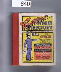
Book, Collins' Street Directory: Melbourne & suburbs 1951, 1951_
... Collins' Street Directory: Melbourne & suburbs 1951....This 1951 street directory covers many Melbourne suburbs but not Greensborough. In the 1950s Greensborough was still a rural settlement. ...Greensborough Historical Society 34A Glenauburn Road Lower Plenty Lower Plenty melbourne This 1951 street directory covers many Melbourne suburbs but not Greensborough. ...This 1951 street directory covers many Melbourne suburbs but not Greensborough. In the 1950s Greensborough was still a rural settlement. This directory is interesting for anyone wanting to check mid-20th century developments.A comprehensive coverage of suburban, inner city streets.Street directory. 411 pages, maps.melbourne, street directories -
 Melbourne Tram Museum
Map, Victorian Railways (VR), "Melbourne and Suburbs", 1956
... "Melbourne and Suburbs"...Map printed by the Victorian Railways in 1955 gives places of interest, some facts about Melbourne, and amusements, with the map showing rail, tram, and railway bus routes, suburbs, golf links, sporting grounds, and municipalities. ...Melbourne Tram Museum 8 Wallen Road Hawthorn melbourne Map printed by the Victorian Railways in 1955 gives places of interest, some facts about Melbourne, and amusements, with the map showing rail, tram, and railway bus routes, suburbs, golf links, sporting grounds, and municipalities. ...Map printed by the Victorian Railways in 1955 gives places of interest, some facts about Melbourne, and amusements, with the map showing rail, tram, and railway bus routes, suburbs, golf links, sporting grounds, and municipalities. The Bourke St tram route to East Preston is shown but not the Nicholson St East Brunswick line which opened during mid 1956. Provides a detailed list of suburbs, miles from the GPO, and how reached from where. Notes it was published in Jan. 1956 by the VR Public Relations and Betterment Board.Demonstrates a Victorian Railways printed map of MelbourneMap - 8 fold printed in colourmaps, melbourne, tramways, bus routes, railways -
 Bayside Gallery - Bayside City Council Art & Heritage Collection
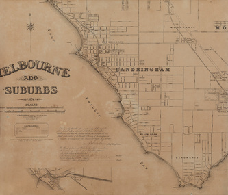
Map, Department of Crown Lands and Survey, Melbourne and Suburbs, City of Sandringham, 1917-1926
... Melbourne and Suburbs, City of Sandringham...Map in black ink on cream paper by the Department of Lands and Survey, Melbourne that indicates area placed under control of the Council of City of Sandringham, on 27 June 1917. ...This was printed in 1926 and is a copy of the original plan from 1917. Melbourne and Suburbs, City of Sandringham Map map Department of Crown Lands and Survey ...map, plan, foreshores, sndringham, hampton, beaumaris, cheltenham, department of lands and survey, cartographic material, borough of sandringham, moorabbin, black rock, street map, city of sandringham -
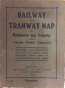 Kew Historical Society Inc
Map, Osboldstone & Co Pty Ltd, Railway and Tramway Map of Melbourne and Suburbs With Tram Timetables, 1917
... Railway and Tramway Map of Melbourne and Suburbs With Tram Timetables...The Railway and Tramway Map of Melbourne and Suburbs With Tram Timetables lists existing Cable Tram Services before the entire network was electrified. ...Kew Historical Society Inc Kew Court House 188 High Street Kew melbourne The Railway and Tramway Map of Melbourne and Suburbs With Tram Timetables lists existing Cable Tram Services before the entire network was electrified. ...The Railway and Tramway Map of Melbourne and Suburbs With Tram Timetables lists existing Cable Tram Services before the entire network was electrified. By 1917 the tramways system was divided into regions including: the Melbourne Cable Tram Service; Prahran - Malvern Electric Trams; Hawthorn Electric Trams; Melbourne, Brunswick and Coburg Electric Trams; and Brighton Beach Electric Trams. The old Outer Circle railway line is marked as ending in Deepdene, with the remainder of the line to Fairfield marked as 'Unused'. The Kew tram along High Street in 1917 ended at the Harp Junction. The Kew Spur Line is also marked on the map.The Railway and Tramway Map of Melbourne and Suburbs With Tram Timetables is historically significant as it captures at a point in time, 1917, the development of public transport infrastructure in Melbourne. As such it illustrrates the theme: Connecting Victorians by transport and communications.Printed card-covered pocket sized map that folds out with three horizontal and vertical folds. Colour map, with scale, of the rail and tram networks on one side and sixteen sections of black and white printed text and timetable information on the reverse.railway maps -- melbourne (vic.), tramways maps -- melbourne (vic.), public transport -- melbourne (vic.) -- 1910-1920, cartography