Showing 98 items matching "river studies"
-
 Sunbury Family History and Heritage Society Inc.
Photograph, River studies
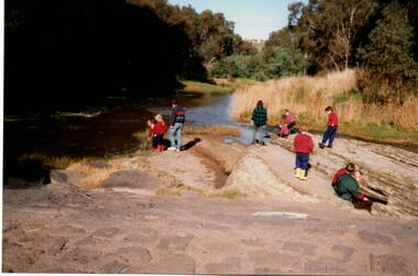
... River studies.......River Studies...Students from Bulla Primary school were taken to the nearby Deep Creek to study some of the river life inn the local water course....River studies. Photograph Bulla Primary School Staff ...Students from Bulla Primary school were taken to the nearby Deep Creek to study some of the river life inn the local water course.Bulla township is situated in the Deep Creek valley and was an ideal place to take students to study river life close to their school.A coloured photograph of eight children with two adults standing on a rocky outcrop beside a river and looking at the riverlife in the water.rivers, deep creek, river studies, bulla, bulla primary school -
 Sunshine and District Historical Society Incorporated
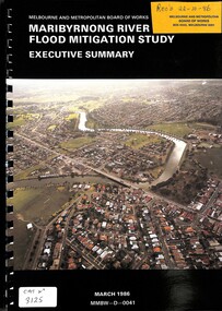
Document - Maribyrnong River Flood Mitigation Study Executive Summary March 1996, Melbourne And Metropolitan Board of Works (MMBW)
... Maribyrnong River Flood Mitigation Study Executive Summary March 1996...Melbourne And Metropolitan Board of Works Maribyrnong River Flood Mitigation Study Executive Summary March 1986...Part of the gwen Goedecke Collection Maribyrnong River Floood Melbourne And Metropolitan Board of Works Maribyrnong River Flood Mitigation Study Executive Summary March 1986 Ring bound document with coloured photo of the Maribyrnong River Document Maribyrnong River Flood Mitigation Study Executive Summary March 1996 Melbourne And Metropolitan Board of Works (MMBW) ...Part of the gwen Goedecke CollectionMelbourne And Metropolitan Board of Works Maribyrnong River Flood Mitigation Study Executive Summary March 1986maribyrnong river, floood -
 Tatura Irrigation & Wartime Camps Museum
Folder, Rural Water Corporation
... Contents include material on dethridge water meter, Murray-Darling basin, Lake Nillahcootie, Western port rivers. Management study of State of the rivers, Rural Water Commission school project package. 3 papers on Lake Dartmouth...Tatura Irrigation & Wartime Camps Museum 49 Hogan Street Tatura the-murray Contents include material on dethridge water meter, Murray-Darling basin, Lake Nillahcootie, Western port rivers. Management study of State of the rivers, Rural Water Commission school project package. 3 papers on Lake Dartmouth rural water corporation tatura water documents reports Folder, marbled black and white cover. metal lever inside Rural Water Corporation Folder ...Contents include material on dethridge water meter, Murray-Darling basin, Lake Nillahcootie, Western port rivers. Management study of State of the rivers, Rural Water Commission school project package. 3 papers on Lake DartmouthFolder, marbled black and white cover. metal lever insiderural water corporation, tatura, water, documents, reports -
National Wool Museum
Book, Scouring the Barwon
... "Scouring the Barwon: an investigation into the operation of a wool-scour and fellmongery on the Barwon River, Geelong; a study in historical archaeology" - Roger D. ...National Wool Museum 26 Moorabool Street Geelong geelong-and-the-bellarine-peninsula "Scouring the Barwon: an investigation into the operation of a wool-scour and fellmongery on the Barwon River, Geelong; a study in historical archaeology" - Roger D. ..."Scouring the Barwon: an investigation into the operation of a wool-scour and fellmongery on the Barwon River, Geelong; a study in historical archaeology" - Roger D. Cummins, 1987. Submitted as part of the final honours examination, Department of Archaeology, La Trobe University. Associated items: results of archeological dig were also donated.scouring, fellmongery -
 Warrnambool and District Historical Society Inc.
Book, Warrnambool Botanic Garden Masterplan, February 1995
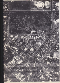
... Study and Report was funded by the National Estate Grants Program of the Australian Heritage Commission and the City of Warrnambool. It was monitored in progress by a Steering Committee consisting of representatives of the Botanic and Public Gardens Advisory Committee, the Warrnambool City Council, Friends of the Warrnambool Botanic Gardens and National Estate Grants Program representatives and community representatives. The Warrnambool Botanic Gardens were first sited close to the Hopkins River...Study and Report was funded by the National Estate Grants Program of the Australian Heritage Commission and the City of Warrnambool. It was monitored in progress by a Steering Committee consisting of representatives of the Botanic and Public Gardens Advisory Committee, the Warrnambool City Council, Friends of the Warrnambool Botanic Gardens and National Estate Grants Program representatives and community representatives. The Warrnambool Botanic Gardens were first sited close to the Hopkins River ...This Warrnambool Botanic Gardens Study and Report was funded by the National Estate Grants Program of the Australian Heritage Commission and the City of Warrnambool. It was monitored in progress by a Steering Committee consisting of representatives of the Botanic and Public Gardens Advisory Committee, the Warrnambool City Council, Friends of the Warrnambool Botanic Gardens and National Estate Grants Program representatives and community representatives. The Warrnambool Botanic Gardens were first sited close to the Hopkins River in 1859. In 1869 the gardens were relocated to the present day location in Botanic Road. This plan is of some importance as it gives an overview of the history and current condition in 1995 of the Warrnambool Botanic Gardens and draws up a plan for its future development. It is useful for research and for consideration by the City Council today of policy making and further development of the gardens. This is a publication containing a master plan for the Warrnambool Botanic Gardens. It has a section on acknowledgements, a summary, eight chapters, and 14 appendices. The pages are bound with plastic rings, the front cover is plasticized with an aerial photograph of the Botanic Gardens and surrounds and the back cover is lightweight cardboard. The pages contain printed material, fold out maps, sketches and diagrams and many photocopied photographs.Front Cover: City of Warrnambool, Warrnambool Botanic Gardens, Conservation and Development Plan, Jill Orr-Young, Patrick Mallon, SF Consultants Pty Ltd, February 1995. warrnambool botanic gardens, warrnambool -
 Warrnambool and District Historical Society Inc.
Book - Album, 1988-1991 Premier Town Volume 2, Circa 1988
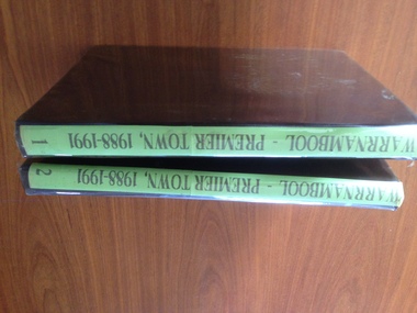
... The following is taken from Hansard at the announcement of the awards in 1988 That the Senate- (a) congratulates the Mayor, Councillors, the Premier Town Committee, and the people of the City of Warrnambool, Victoria, for their achievement, on Saturday, 20 November 1988, in taking out the Victorian `Premier Town Award' for an unprecedented third time; (b) congratulates the business people of Warrnambool for their efforts in helping the city to win the Victorian Industrial and Commercial Development Award, including a special award for coastline preservation and studies This album is significant in that it documents an important award to the City of Warrnambool. It is also a comprehensive pictorial record of Warrnambool as it was in 1988.Volume 2. Covers Warrnambool rivers ...The Premier towns is an award given by the Victorian state Government. It recognises positive actions by regional communities to protect and enhance their local environment. It is based on criteria relating to litter prevention and waste management, environmental and heritage management as well as activities among community groups and leadership. The following is taken from Hansard at the announcement of the awards in 1988 That the Senate- (a) congratulates the Mayor, Councillors, the Premier Town Committee, and the people of the City of Warrnambool, Victoria, for their achievement, on Saturday, 20 November 1988, in taking out the Victorian `Premier Town Award' for an unprecedented third time; (b) congratulates the business people of Warrnambool for their efforts in helping the city to win the Victorian Industrial and Commercial Development Award, including a special award for coastline preservation and studies This album is significant in that it documents an important award to the City of Warrnambool. It is also a comprehensive pictorial record of Warrnambool as it was in 1988.Volume 2. Covers Warrnambool rivers, bridges, coastal features, places of learning, clubs and sporting facilities and historical and general interest all of which have played an important role in the development of and history of the city and lives of its people.Soft brown vinyl cover with plastic cover. Pages are dark cream cover paper. A sticker with the Warrnambool Premier Town logo is inside the front cover. The album consists of photographs of various buildings and streetscapes with relevant descriptive text.Sticker inside front cover, Mr J Gietz Po Box 1007 Warrnambool Vic 3280. warrnambool, ideal town 1988-1991, victoria’s bicentennial premier town premier town awards -
 Kiewa Valley Historical Society
Collection - Ian Roper
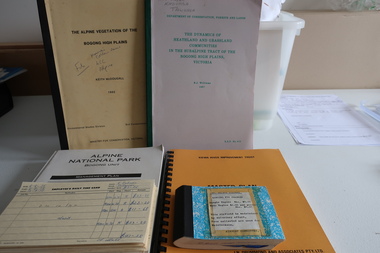
... studies ordered by the Victorian Government and the Alpine shire. History of the Kiewa Valley and North East Victoria including the airport at Mount Beauty Ian Roper Mount Beauty Airport pygmy possums vegetation A collection of publications and Items significant to the Kiewa Valley Including Kiewa Valley and Surrounds, the Kiewa River, and Pygmy Possums. ...Various reports and studies ordered by the Victorian Government and the Alpine shire.History of the Kiewa Valley and North East Victoria including the airport at Mount BeautyA collection of publications and Items significant to the Kiewa Valley Including Kiewa Valley and Surrounds, the Kiewa River, and Pygmy Possums. Also items and reports relating to the North East of Victoria. 1. Kiewa River Improvement Trust- Master Plan 1984. 2. Guidelines Conservation Mountain Pygmy Possum -Management Strategy 1989. 3. Proposed Interim Management Plan -Bogong National Park 1983. 4. The Dynamics of Heathland and Grassland Communities in the Subalpine Tract - Bogong High Plains 1987. 5. Alpine National Park Bogong Unit -Management Plan 1992.6. Alpine Vegetation of the Bogong High Plains - Bogong High Plains 1982. 7. Early 1970s onwards, records of banking, receipts, landing fees, letters, photos, key, minutes, visitor book, record of landings (book), postcards, SEC Victoria's Kiewa Valley Brochure - Mt Beauty Airport History 1`977+ian roper, mount beauty airport, pygmy possums, vegetation -
 Kiewa Valley Historical Society
Papers - Certificates - Edward Maddison
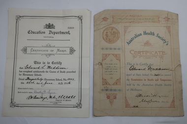
... river and operated part-time with nearby schools on occasions as well as full time. As numbers fluctuated it was also closed on occasions and then re-opened. Edward Maddison's family were farmers in the Kiewa Valley and the children attended the local school. Edward Maddison Australian Health Society Mongan's Bridge School Two certificates belonging to Edward Maddison 1. 1916 Pupil of State School No 3403 (Mongan's Bridge) - passed the Examination in Health and Temperance held by the Australian Health Society of Melbourne 2. 1916 Completed satisfactorily the Course of Study prescribed for Elementary Schools.- Mongan's Bridge Elementary School No. 3403 Papers - Certificates - Edward Maddison ...The Australian Health Society was formed in Melbourne in 1875 at the instigation of Unitarian Minister MarthaTurner. It promoted hygiene and comprised of doctors, prominent citizens and politicians. It targeted poorer districts and women. Schools were pressured to place health education on the curriculum. Society stalwarts made an annual examination in state schools. Mongan's Bridge No. 3403 opened in 1902. It was located beside the Kiewa river and operated part-time with nearby schools on occasions as well as full time. As numbers fluctuated it was also closed on occasions and then re-opened.Edward Maddison's family were farmers in the Kiewa Valley and the children attended the local school.Two certificates belonging to Edward Maddison 1. 1916 Pupil of State School No 3403 (Mongan's Bridge) - passed the Examination in Health and Temperance held by the Australian Health Society of Melbourne 2. 1916 Completed satisfactorily the Course of Study prescribed for Elementary Schools.- Mongan's Bridge Elementary School No. 3403edward maddison, australian health society, mongan's bridge school -
 Kiewa Valley Historical Society
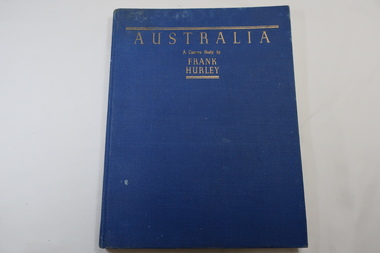
Book - Book- Photos, Australia - A Camera Study by / Frank / Hurley
... River just below the Hume Dam and Mt Buffalo and Mt Kosciusko are part of the Alpine High country near the Bogong High Plains. Clare Roper lived on a farm in the Kiewa Valley. Frank Hurley photographer Australian photography Clare Roper Inside back of first page - written 'Clare Roper' Blue hard cover, bound book with the title in gold at the top. 208 pages. Mostly Black & white photos but some coloured. Australia - A Camera Study ...Frank Hurley (1885-1962) was an Australian photographer and adventurer. He participated in trips to Antartica and was an official photographer with the Australian forces during both world wars. This book was first published in 1955.Photographs include the Hume Reservoir, Mt Buffalo and the Alpine High Country of Mt Kosciusko. (pages 140-144) All are associated with the type of country at each end of the Kiewa River. The Kiewa River flows into the Murray River just below the Hume Dam and Mt Buffalo and Mt Kosciusko are part of the Alpine High country near the Bogong High Plains. Clare Roper lived on a farm in the Kiewa Valley.Blue hard cover, bound book with the title in gold at the top. 208 pages. Mostly Black & white photos but some coloured.Inside back of first page - written 'Clare Roper'frank hurley photographer, australian photography, clare roper -
 Kiewa Valley Historical Society
Book - Reference Botany, Botany - A Junior Book For Schools, 1927
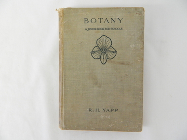
... study all the fundamental teaching that this book encompassed. This in one way provided students in the valley a slightly better appreciation between book and real life (on the land, in the field and by the river). ...This book was a highly regarded reference book for students in primary and lower secondary schools within Victoria from the late 1800s to the mid 1900s. The book provided students with the fundamental knowledge of botany for the era in which it was produced. As this book was targeting a junior schooling level (basic), it could cover a greater and extended reader population. Teaching institutions could, because of its straight forward, basic written information, retain this book's circulation for a greater length of time, thereby optimising the return against the greater initial costs of importing it from England.This book was produced in a time where learning was at a relatively slower pace (due to a smaller source and supply of material). The availability of a large range of cheap reference books such as that offered from 1971 on wards via the internet "Project Guttenberg" in the form of electronic books, has dramatically provided a larger source of reference material. The significance of this book on botany, is that it was highly effective for the era in which it was produced and in particular the students at a rural based school. Being in a rural area students were able to identify local vegetation to the various life cycles of plants presented in this mainly United Kingdom/European referenced book. The students in the Kiewa Valley and attending a rural school, where in a position to study all the fundamental teaching that this book encompassed. This in one way provided students in the valley a slightly better appreciation between book and real life (on the land, in the field and by the river). Later publications of this book had additional Australian references in them.This hard covered book(cloth strengthened) is faded(aged) beige in colour and consists of 204 pages. It is printed in English (black print) on both sides and contains illustrations of both free hand sketches and photographs of plants, both foliage and roots systems. The book is arranged in three sections: three pages of preface, two of contents (28 chapters). The last four pages contain the appendix and index.On spine "BOTANY" underneath "R.H. YAPP" and at bottom the Cambridge coat of Arms and below this "CAMBRIDGE" The front cover "BOTANY" underneath this "A JUNIOR BOOK FOR SCHOOLS" and below this a an illustration of a four leaf petal(flower of Germander Speedwell) the same as appears on the cover of edition 2, however this book is edition 3. At the bottom is "R.H. YAPPschool, botany, text books, science experiments, nature -
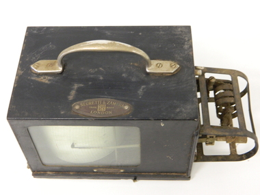 Kiewa Valley Historical Society
Barometer Anoroid, circa mid to late 1900's
... rivers within the Kiewa Valley. Time since the start of the project has verified the use of instruments such as this barometer and the information gained from its use that the success of any large impact upon a sensitive environment requires a thorough and systematic study before implementation. ...This barometer was part the hydrology and forestry groups working within the SEC Vic Hydro Scheme from the initial appraisal review long before any construction began in the 1940's. The river flows and rainfall patterns had to be established before any construction of holding dams or tunneling could commence. This barometer is very relevant to the Kiewa Valley history because it presents the high degree of professional and technical information required at the time before implementing the "Scheme" upon the virgin alpine region and its effects upon the "natural" flows of the rivers within the Kiewa Valley. Time since the start of the project has verified the use of instruments such as this barometer and the information gained from its use that the success of any large impact upon a sensitive environment requires a thorough and systematic study before implementation. Weather records were kept of temperature, wet-bulb temperature, wind direction, speed and barometric pressures. To record barometric pressure a meter was devised with a clockwork mechanism which took one week to do a revolution. A chart was fitted to a drum and had an ink pen shaped like a little shovel. The shovel was filled with ink and was checked daily. To calibrate the barometer it was sent to the Melbourne General Post Office to be compared against the one there (at sea level). After calibration it was sent back to the Bogong Camp.On plaque on top side."NEGRETTI & ZAMBRA" underneath this and in smaller print "TRADE MARK" below this "LONDON" On the bottom and in small print "HOBART DUFFPty Ltd COLLINS HOUSE MELBOURNE C1"kiewa hydro electricity scheme, victorian state electricity commission, transformers, resistors, barometers -
Federation University Historical Collection
Document, Zelda Martin, Central Victorian Goldmining towns - Boom Towns or Ghost Towns?, c1996
... River, Old Portland Bay Road, plaque on road to Colac; etc. *Newspaper article re 'The Theatre Royal' ( which stood in the vicinity of the current Owen Williams store) - 'The News'15/04/1998 *Article - 'Ballarat's Mechanics' Institute Lives On' Ballarat Courier, 14/09/1985 *Article - Standing the Test of Time' The News 17/11/1993 re The Mechanics Institute & picture of the Reading Room *'Ballarat a Study of a City, Phyllis Reichl, pub. ...River, Old Portland Bay Road, plaque on road to Colac; etc. *Newspaper article re 'The Theatre Royal' ( which stood in the vicinity of the current Owen Williams store) - 'The News'15/04/1998 *Article - 'Ballarat's Mechanics' Institute Lives On' Ballarat Courier, 14/09/1985 *Article - Standing the Test of Time' The News 17/11/1993 re The Mechanics Institute & picture of the Reading Room *'Ballarat a Study of a City, Phyllis Reichl, pub. ...Zelda Martin was a PhD candidate at the University of Melbourne.[.1] 4th item in light blue display book titled Research Approach/Overview of Chapters/Confirmation of Canditure/Chapters1,2,3&4 of proposed thesis. *Twenty-seven page article on Victorian goldfields towns titled: Central Victorian Goldmining Towns - Boom Towns or Ghost Towns. The article was written during the author's PhD study. It outlines the context methodology, and resources and the chapters of the proposed thesis: (1) Central Victorian Goldmining Towns - The Context (2) Contemporary Views of the Factors Necessary for Town Growth (3) Outward Manifestations of Town Growth (4) The Trappings of Government (5-9) The Main Towns and Their Hinterland. [.2] 5th item in Light Blue display book as above item. *Chapter 1 of proposed thesis titled 'Pick, Shovel and Tin Dish Mining.' Covers in Section A: Central Victoria - Pre 1851: Aborigines in Central Victoria, Squatters, and Government. Section B: The years 1851-1854: The Early Gold Rushes, Government Reaction, Township Surveys, Legislation, Town Development, Local Government and Early Settlement. [.3] 6th item in Light Blue display book as above item. *2A of proposed thesis titled 'Contemporary Views of the Factors Necessary for Town Growth'. Similar information to Chapter 1 plus extra re towns and maps. Sections: Introduction, Context of Place - Geographical Towns Listed, The Context of Time - Pre1851 Aborigines, Governance of Port Phillip, The Squatters, The Villages of Central Victorian Highlands, Conclusion, Condensed Version of Chapter2B. [.4] 7th item in Light Blue display book as above item. *Chapter2B of proposed thesis. Sections: Area of Research, Schools, Banks, Newspapers, Progress Association, Town Development - Sandhurst (Bendigo), Ballarat, Castlemaine,, Maryborough, Ararat and Stawell. [.5] 8th item in Light Blue display book as above item. *Chapter 3 of proposed thesis titled 'Outward Manifestations of Town Growth'. Sections: Introduction, Contemporary Writing, Educationalists, The Bankers, The Townsfolk, Current Theory, General Theories of Urban Development, and Conclusion. [.6] 9th item in Light Blue display book as above item. *Chapter 4 of proposed thesis titled 'Trappings of Government' Sections: Introduction, Early Government Attitudes to Mining and Town Development, Law and Order, Township Surveys, Legislation, Local Government, Transport and Communication, The People and Lobbyists. [.7] 10th item in Light Blue display book as above item. *'The Rise and Fall of Central Victorian Goldmining Towns'. Includes a map showing main Goldfields, a table showing towns and villages at two points in time - 1857 and 1871; a Bibliography of Primary and Secondary Sources. [.8] Resource No1. Black display book titled Local Towns 1 : Alma: *Brief history *Directory *Maps Amphitheatre / Mountain Hut: *Brief History Post Office Directory Ararat: *Brief History *Post Office Directory 1869 - Alphabetical Listing by Occupation *Ararat - Prominent Citizens of 1858 *Langi-Morgala Museum Avoca: *Brief History *Excerpts from 'Avoca The Early Years', Margery and Betty Beavis; pg1 - Beginnings; pg11 - The Midas Touch; pg25 - Local Gold Escorts; pg27 - A Town is Born; pg51- The Administration of Justice; pg53 - The Ways of the Law; pg61 - News of the Day; pg65 - A Time to Play; pg72 - Land Ownership *Post Office Directory (Bailliere's) 1869 *Tourism Map and Information of area *Historic Avoca - A 5.5km Tour *Avoca & the Pyrenees Region - information pamphlet Ballarat: *Early History of Ballarat - Ballarat Historical Society, Publication No.1: origin of the name; Ballaarat - the Beginning; Fabulous Yields from the Ballaarat Goldfield; *Streetscape Lydiard Street. *Hand drawn map showing Leigh River, Old Portland Bay Road, plaque on road to Colac; etc. *Newspaper article re 'The Theatre Royal' ( which stood in the vicinity of the current Owen Williams store) - 'The News'15/04/1998 *Article - 'Ballarat's Mechanics' Institute Lives On' Ballarat Courier, 14/09/1985 *Article - Standing the Test of Time' The News 17/11/1993 re The Mechanics Institute & picture of the Reading Room *'Ballarat a Study of a City, Phyllis Reichl, pub. Nelson, 1968; no.3 place, time and people field studies series *Investigator Vol.33 No.2, 1998 Geelong Historical Society. Article on pg75 describes Ballarat in 1861 *Folded poster - 'Ballarat 100' a history of telegraph communication, pub. Telecom. Beaufort (Fiery Creek): *Brief history *Post Office Directory [.9] Resource No.2 Black Folder Titled Towns cont.No2 Bendigo (Sandhurst): *'Family & Local History at the Bendigo Library - 1851-2001 150 years of gold'. *Bendigo Government Camp in 1853 illustration; key to sketch and names of Government officers stationed there *Excerpts from 'Bendigo and Vicinity' Adolph Haman *The Bendigo Goldfield Registry - pgs 1-7 Introduction *Excerpt: 'Breaking the Grip' *Excerpt: The Most Go-Ahead Place *Excerpts from 'History of Bendigo' - anti license agitation; laying out of town; proposed railway; gold calls and dividends; the Sandhurst Municipality; journalism *Bibliography Blackwood: *Excerpts from 'Aspects of Early Blackwood - The Goldfield, the Landmarks, the Pioneers' Alan J Buckingham and Margaret F Hitchcock, JG Publishing,1980 Buninyong: *A Brief History *Investigator Vol1 No.2 Feb 1966 Geelong Historical Society. Pg3 - Article re gold escort route - Mt Alexander to Adelaide - (see a simple monument on the Western Highway a few miles out of Horsham. Pg 15 - Ballarat Excursion - re the finding of gold. *Three articles published by Buninyong and District Historical Society Inc: (Magpie Exploration; Finding Gold In The Green Hills; Magpie Exploration; Burnt Bridge to Cargarie to Mt Mercer) *Copies of newspaper articles/items *Buninyong Street Directory Carisbrook: *In the Beginning There Was Carisbrook *The History of the Carisbrook Racecourse Carngham / Snake Valley: *Brief History *Directory Castlemaine: *Directory 1865-1866 - Alphabetical and Street *Poster - Castlemaine A Contemporary Guide "The Great Centre" 1866 - A Contemporary Guide to the Fascinating Past *Pamphlet - Castlemaine District Community Hospital *Map - Castlemaine, Maldon & Surrounding Districts *Map and Information - The Dry Diggings Track - a 55kl walk among historic goldfields relics ( Castlemaine Fryerstown Vaughan Mt Franklin Hepburn Daylesford) *Postcard - Former Court House *Directory 1867 - Alphabetical, Trade [.10] Resource No.3 Grey folder Titled Towns 3 Creswick to Maryborough Creswick: *Brief History *Booklet - "Creswick Cemetery Walk" *Booklet - The Buried Rivers of Gold Heritage Trail Creswick *Creswick Historical Museum Information Sheet *Chronological History of Creswick *Alphabetical Directory of the Borough of Creswick *Creswick's Creek Directory 1856 *Historic Creswick Walking Tour *A Brief Account of the Schools of Creswick - Past and Present *100 Years of Railway Travel in Creswick *The Berry Deep Leads *The Spence Home at Jackass Gully in the Creswick State Forest ( William Guthrie Spence - Pioneer) *The New Australian Mine and the 1882 Disaster *Creswick District News, Issue 7, July August 1999 *The Creswick Miners Walk - Information and Map *Maps Chewton: *Brief History *Directory Clunes: *Brief History *Clunes Street Directory Daylesford: *Brief History *Notable Bushfires in Daylesford District Over More Than a Century - "Black Thursday" 1851; 1862; 1899; the Disastrous Hepburn Fire of 1906; 1939; 1944; 1969. *Post Office Directory -Daylesford and Hepburn Dunolly / Inkerman: *Brief History *Directory *Pamphlet - Goldfields Historical Museum *Pamphlet - Historic Dunolly - Victoria's Best Kept Secret *Map of Gold Workings at Dunolly Area - showing where the main gold rushes occurred *Brief History - Inglewood *Directory - Inglewood - Name Occupation, Dwelling Kingower: *Brief History *Directory - Name / Ocupation / Dwelling Linton / Happy Valley / Piggoreet: *Brief History *Directory - Lintons McIvor: *"A History of the Shire and the Township of Heathcote" by J.O. Randell Majorca: *Brief History *Official Post Office Directory 1869 - Name / Occupation/ Address Maldon (Tarrangower): *Brief History Part 1 *Brief History Part 2 *Post Office Directory *List - Alphabetical Order by Names plus Business and Trade (Tarrangower Times Oct/1858) *List - Alphabetical Order by Trade plus Name and Business *Directory - Name / Occupation / Dwelling Maryborough: *Worsley Cottage - built by Arthur Worsley, a contractor in stonework in 1894 [.11] Resource No. 4 Blue Display Book titled Towns 4 Moliagul to Stawell Moliagul: *Brief History *Moligul Legislative Assembly (Voting?) List - Names and Occupations *Moliagul Victorian Post Office Directory 1868 - Name / Ocupation / Address / Comments *"The Welcome Stranger" gold nugget *The Sunday School *The Welcome Stranger Discovery Walk - information and map Moonambel (Mountain Creek) Redbank *Brief History *List of names extracted from advertisments of the Pioneer and Mountain Creek Advertiser 16/02/1861. *Bailliere's Directory 1869 - Alphabetical List of Name / Occupation / Place St Arnaud: *Brief History Sebastapol: *Brief History *Directory 1869 - Alphabetical by Name; plus occupation and address. Browns and Scarsdale: *Brief History *Browns Street Directory - Name and Occupation Smythesdale: *Brief Description *Smythesdale Street Directory -Name and Occupation Stawell (Pleasant Creek) *Brief History *Victorian Official Post Office Directory - Name /Occupation / Dwelling *Chronology - 1841-1920 *Production of gold statistics - 1879 - 1900 *Big Hill *Extracts from "The Golden Years of Stawell". Chapt 1 - Stawell's Coming Out. Capt. 2 - The Gold Rush. Caapt.3 - Cradle of Democracy. Chapt.4 - The Reefs Becomes Stawell. Chapt. 5 - Rushing In. Chapt.6 - The Pioneers. Chapt 7 - The Decade of Optimism. [.12] Resource No. 5: Blue Display Book titled 'Towns Steiglitz to the The Golden Triangle. Steiglitz: Brief History Victorian Post Office Directory 1869 *Map of Steiglitz *List of maps relevant to Steiglitz history *Information 6 tables of data from "Reports of Mining Surveyors Talbot (Back Creek) Brief History Taradale: Post office Directory 1869 - Name/Occupation/Street. Also list in alphabetical order by Occupation Taradale *Chronological Reference to Taradale Mines *Water - The Coliban System of Waterworks *Joseph Brady *The Syphon Tarnagulla (Sandy Creek) *Brief History *Tarnagulla Businessmen Cameos to give depth to advertisments in 'The Tarnagulla Courier' various issues 1864-1871 *Directory - Name/Occupation /Address *List - Name/Business/Trade Wedderburn (Koorong) *Brief History *List - Name/Occupation The Golden Triangle: *The Early Rushes - Wedderburn / Moliagul / Sandy Creek - Tarnagulla / Jones Creek - Waanyarra / Kingower / Dunolly - Goldsborough / Inglweood *Census of 1857 - Population / Occupations *1858-1871 - A Time of Consolidation- Wedderburn / Moliagul / Sandy Creek- Tarnagulla / Arnold *Census 1871 - Population *Information gleaned from the census data - Demographics / Population / Occupations / marital / Birthplace / Religion / Literacy/ Occupation and Housing Cameos *Graphs - Birthplace of settlers /Male-Female Ratio / Married males / Children under 15 as Percentage of Population / Religion *Census 1857 - Statistical data *Maps *Bibliography [.13] Resource No. 6 - Black Display Book Information and Research in Central Victoria including: *Banking - Research from ANZ Bank Archives *Institutions - also includes articles listed from the Ballarat Times Newspaper *Australian mining History Association - A.M.H.A. Bibliography *Australia's Mining History * Bibliography - Land Surveys Victoria - *1853 Administration (Statistics and Other) includes: schools / ministers of religion / police / military / local administration / licences for sale of spirits / distances between various Victorian gold fields. * Victoria Government Gazette (Copy) - N0. 116, 12/12/1854 includes: Gold Felds Commission of Enquiry & No. 85, 15/09/1854 - Addresses presented to the Lieutenant Governor (Sir Charles Hotham) during his tour through the Gold Fields of Victoria,1854. Addresses on behalf of : the people of Bendigo; Members of the Church of England, Bendigo; Members of the Wesleyan Church on the Bendigo Gold Fields; Bendigo Gold District General Hospital; the Bendigo Prospecting Association; Committee of the Bendigo Local Exhibition; Bendigo District Medical Association; Coloured Americans Resident at Bendigo; German Inhabitants of Bendigo; Landowners, Inhabitants, and Miners of Castlemaine; Inhabitants of Forest Creek; Inhabitants of Heathcote and Gold Miners of McIvor; Residents and landholders of the District of Bacchus Marsh; Inhabitants of Kilmore and Vicinity. *Gold Fields Correspondence 1853: letter from Lieutenant Colonel Valiant, (Officer commanding the Troops in Victoria) to the Lieutenant Governor re threatened disturbance at Sandhurst (Bendigo) regarding the Gold License Fee. * Extracts from a book "Victoria" re Gold Fields Commission of Enquiry involving mainly Ballarat and Castlemaine and a chapter titled 'A Tour to the Victorian Gold-Fields' *Lists of central Victorian newspapers - listed by date published 1851to 1874; by first date available to State Library. *A list of cities and towns showing County, population in 1861 &1871, and municipal status. [.14] Resource no.7. Black display book. *Reference: Papers presented to Parliament Victoria - 1859-1860 4 volumes - relevant sections copied. Contains information on Branches of Government. General / Finance / Gold / Gazette / Commission and Warrant / Statistic. *Gold Fields Act. In accordance with the Act the gold fields are divided into six districts - Ballaarat, Castlemaine , Sandhurst, Avoca, Ararat, and Beechworth.. Official staff in each gold district consists of a Resident Warden, Wardens, Wardens' Clerks, Bailiffs, Chinese Protectors, Chinese Interpreters, and Mining Surveyors. *Gold Receiver *Gaols *Police magistrates and Clerks of Petty Sessions, etc. *Field Branch *Immigration and Emigration Overland - Chinese - 1859 *Population on the Goldfields *The Geological Survey - The Government Geologist is assisited by staff from four branches - the office Branch; the Publishing Branch; the Field Branch and the Museum Branch. *Commission to Enquire Into Sludge dated 10/02/1859 (Some sections copied) - Report to the Honorable Chief Commissioner of Public Works, Melbourne re the mode of carrying the sludge from the puddling mills in Sandhurst without interfering with the drainage of the town and the roads in the neighbourhood. [.15] Resource No.8: Camel display book titled Resource No. 8. Aborigines *Lists of book titles - +"Readings in Victorian prehistory" +"The Aborigines of Port Phillip" +Aboriginal languages and clans" +"A History of the Port Phillip District" +"Langi Ghiran 1: Aboriginal Rock...." +"Koorie History: sources for aboriginal studies in the State Library of Victoria", ed. Tom Griffiths, Melb. Friends of the State Library, 1989 +"The Public Lands of Australia Felix"; settlement and land appraisal in Victoria1834-91 with special reference to the Western Plains", J.M.Powell, Melb. Oxford University Press 1970 +*Bibliography of the Victorian Aborigines' from the earliest manuscripts to 31st December 1970, Massoa, Aldo, Melb. Hawthorn Press, 1971 +"Aborigines in Colonial Victoria, 1836-1886", M.F. Christie, Sydney University Press, 1979 +"Urban and Industrial Australia: readings in Human Geography" ed J.M. Powell, Melb. Sorrett Pub. 1974 *Extracts: -Processes of Pioneer Settlement - The Squatting Occupation of Victoria, 1834-60. J.M. Powell -Areal Variations in the Class Structure of the Central-Place Hierarchy. P. Scott - Volume1 and Volume 2: Notes Relating to the Habits of the Natives of Other Parts of Australia and Tasmania. Compiled from various sources for the Government of Victoria by R Brough Smyth. John Curry, O'Neil, Melb. 1st pub. Melb. 1876. p31-45 - Numbers and Distribution of the Aborigines in Victoria -Victorian Aborigines 1835-1901 - A Resource Guide to the Holdings of the Public Record Office, Victoria; published by the Government Information Centre 1984. *History of the Aboriginal Artefacts Displayed in the Daylesford Museum. F. G. Powell (4 page pamphlet) *Letter to Zelda Martin from Peter Lovett, Cultural Officer, Ballarat & District Aboriginal Co- Operative, 05/02/1997 *Map: Ian Clarke Victorian Tribunal Boundary Map - Clans of Central Victoria. *Victorian Rock Art and Mythology - Article about Mount Langhi Ghiran and myths of the Tjapwarong people. *Two Aboriginal myths relating to the Grampians - 'The Monster Emu' / 'The Aquisition of Fire', by the Aborigines in the Grampians Areas *Article titled (chapter 8) Ballarat - information re camping sites in the region. Lake Wendouree / Lake Burrumbeet (includes a myth) / Mt Bunninyong / Lal Lal / Pitfield / Mount Elephant / Mount Egerton / Meredith / Lake Goldsmith / Lake Learmonth / Ercildoune *Notes on the Aborigines of the Wider Ballarat Region plus European names=Aboriginal names. John Morris 26/07/1995 *Role of Aborigines in Town Development in Central Victoria. Mentions Native Police Force est. in Port Phillip 1842 and Central Board for Aborigines est. 1860 *The Grave of King Billy. (Frank Wilson) Pamphlet. *Camping Places in Central and Northern Victoria. Article re Lake Burrumbeet site. *Programme for the Unveiling of Memorial Cairn for Edward Stone Parker 1802-1865. Note portrait not accurate. Accurate portrait is available in the book "A Successful Failure A Trilogy The Aborigines and Early Settlers", Edgar Morrison, Graffiti Publications, 2002. * Large envelope addressed to Mr G Netherway containing newspaper cuttings regarding the life of Edward Stone Parker, the unveiling of the Memorial Cairn as mentioned above, articles titled 'Episodes from Our Early Days' (Edgar Morrison, Yandoit)- The Black's School, A School At Last and The Final years. Also a typed page titled 'Historical Background to E.S.Parker's Career. Includes an interesting tale titled 'When the cat lay doggo' re laying power leads for the unveiling ceremony at the memorial site. [.16] green display folder titled 'Research Aids' *List of references to Commissioners' & W'ardens' Reports (formerly held at La Trobe Library Archives, now at Public Records Office [PRO]). Indicates town referred to / date of report / name of camp if different to town. * Archive information re Anglican Records *Movement around the Goldfields - Miners and Storekeepers - usefulness of newspapers in providing information - areas covered - Castlemaine, Maldon, Ararat, Stawell, Tarnagulla, Dunolly. *Port Phillip /Victoria Directories 1839/1867 - Chronological list of Directories included in this series. *"Notes on the History of Local Government in Victoria" A.W. Greig Melb. University Press 1925 - Photo-copied extract p5-p40. (Source - Deakin University Library) - Introduction by W.Harrison Moore. Section 1 - Development in New South Wales Before Separation. Section 2 - Development in Victoria After Its Separation from New South Wales. Hand written notations: 'roads, markets, and local government 1855 on' ;'opportunity of squatters in parliament' and 'opportunities of matters in parliament p33' * Notes on the Establishment of Surveyor General's Department 1851and Commissioner of Crown Lands and Survey. * Newspaper articles from The Argus, 1849, re the discovery of gold in the Pyrenees region. * Excerpt - a report on schools - A.B.Orlebar, Inspector; re the need for permanent school buildings rather than tents. *Excerpt from - 'Approaches to Urban History', Sean Glynn: The Case for Caution * Except from - 'The Urban Sprinkle', Weston Bate: Country Towns and Australian Regional History *Reference- 'The History of Land Tenure in the Colony of Victoria', John Quick. References the Haines Land Bill, land tenure and Land Leagues. [.17] Light blue envelope folder titled 'Birtchnell's Ballarat, etc. Directory 1862 *Contains various directories for Smythesdale, Buninyong, Clunes, Brown's and Creswick. [.18] Red envelope folder no.2 titled Victorian Gazetteer *Selected pages from 1869 Victorian Gazetteer on A4 paper (with a handwritten note questioning if some pages are from 1868 Victorian Gazetteer as appears to be different sizes - A3 pages.) Information includes locations and descriptions of towns, hotels, banks, communications and populations. (Does not include names, residences and occupations) [.19] Red Envelope folder titled Bailliere's Official Post Office Directory 1868 (or1869 or a mixture of both?) *Preface *Contains a selection of pages of towns highlighted in yellow in the the index *Work on this directory was commenced in 1867. *Information includes: Municipalities - mayors and councilors; lists of towns naming male inhabitants and their occupations. [.20]Yellow manila folder titled Post Grad Seminar Presentation 1996 *Gives some background to Zelda Martin's proposed thesis and why she chose the topic Gold Mining Towns Boom or Bust [.21] A3 display book - No. 1A * A list of 'Relevant Newspapers collected: The Tarrangower Times and Maldon Advertiser (first published 1858) Includes dates 1858-1867. The Mount Alexander Mail. Includes dates 1854-1866 The Tarnagulla Courier. Includes dates from1864-1871 Dunolly and Burnt Creek Express. Includes dates from 1862-1871 * Selection of newspaper pages from The Mount Alexander Mail 1854 to 1856, mostly showing advertisements for businesses and services provided to that community. [.22] A3 display book - No. 1B * Selection of newspaper pages from The Mount Alexander Mail 1857 to 1866, mostly showing advertisements for businesses and services provided to that community. [.23] A3 display book -No. 2 * Selection of newspaper pages from The Tarnagulla Courier 1864 to 1871, mostly showing advertisements for businesses and services provided to that community. [.24] A3 display book - No. 3 *Selection of newspaper pages from The Tarrangower Times (and Maldon and Newstead) Advertiser 1858 to1867, mostly showing advertisements for businesses and services provided to that community. [.25] A3 display book - No.4 * Selection of newspaper pages from The Dunolly and Burnt Creek Express; and The Dunolly and Betbetshire Express 1862 to 1871, mostly showing advertisements for businesses and services provided for that community. [.26] A3 display book - No.5 Includes: * Bryce Ross's Diggings Directory. Includes instructions for using this directory. This directory was used by "all persons having connexion or desiring to communicate with 'working parties, private friends, or Stores at the Diggings." As a directory for each area wwas completed it was published in each month's issue of Bonwick's "Digger's Magazine." Years c1852/1853. This Directory commences first at the head of Forest Creek. Includes a directory for Bendigo and Ballarat. Of interest at the end of the Bendigo and Ballarat directory is a list of the number of storekeepers, butchers, doctors, smiths, eating houses, lemonade sellers and chapels. * The Castlemaine Directory and Book of General Information Comprehending Glass's Model Calendar for the Two Years 1862 and1863. "zelda martin, victorian goldfield towns, bendigo, castlemaine, ballarat, maldon, stawell, ararat, maryborough, creswick, avoca, heathcote, banks, bank of australasia, union bank of australia, government camp, sandhurst, water supply, tarnagulla, talbot, back creek, mountain creek, police court, carisbrook, dunolly, thompson's foundry, charles clacy, anthony trollope, robert cecil, mount alexander, urbanisation, national schools, education, govenrment, industry, railway, transport, settlement, land settlement in central victoria, steiglitz, joseph brady, the new australian mine, berry deep leads, william guthrie spence, creswick state forest, arthur worsley, worsley cottage, the welcome stranger, moliagul, moonambel, redbank, st arnaud, sebastapol, brown's, scarsdale, clunes, chewton, daylesford, bushfires, inkerman, inglewood, kingower, lintons, happy valley, piggoreet, mcivor, majorca, tarrangower, taradale, the coliban system, the syphon, sandy creek, wedderburn, koorong, arnold, jones creek, waanyarra, the golden triangle, census 1857, blackwood, buninyong, durham lead, magpie, carngham, snake valley, alma, amherst, daisy hill, amphitheatre, mountain hut, beaufort, fiery creek, counties, population, gold fields commission of enquiry1854, william westgarth, gold license fee, lieutenant colonel valiant, administration of the victorian gold fields, commission to enquire into sludge 1859, e.s. parker, edward stone parker, edgar morrison, mount franklin protectorate, dja dja wurrung, memorial cairn, franklinford, mt franklin memorial cairn, jajowurrong, dja dja wurung, tjaowarong, wothowurong, assistant protectors, daylesford museum, buluk, rock art - grampians, aboriginal mythology - grampians, aborigines, first nations people, mount franklin, aboriginal artifacts, lake burrumbeet, native police force, central board of aborigines, yandoit, commissioners' reports, wardens' reports, port phillip/victoria directories 1839-1867, local government - victoria 1853/1854, surveyor general's department - 1850's, victorian schools 1850's, a.b.orlebar, haines land bill, william charles haines, wilson gray, land tenure, land leagues, victorian gazetteer, the tarrangower times and maldon advertiser - 1858-1867, the mount alexander mail 1854-1866, the tarnagulla courier 1864, dunolly and burnt creek express 1862-1871, bryce rose's diggings directory, the castlemaine directory 1862-1863 -
 Orbost & District Historical Society
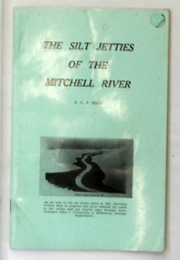
book, James Yeates & Sons (Printing) Pty Ltd, The Silk Jetties of the Mitchell river, 1972
... studies of Gippsland to be published by the Bairnsdale Advertiser. The author, Eric Charles Frederick Bird was Principal Fellow, Department of Geography, University of Melbourne, Australia. The Mitchell River...studies of Gippsland to be published by the Bairnsdale Advertiser. The author, Eric Charles Frederick Bird was Principal Fellow, Department of Geography, University of Melbourne, Australia. The Mitchell River ...This booklet was the first of a series of scientific and historical studies of Gippsland to be published by the Bairnsdale Advertiser. The author, Eric Charles Frederick Bird was Principal Fellow, Department of Geography, University of Melbourne, Australia. The Mitchell River silt jetties are an unusually long, thin landform located in the Gippsland Lakes region. They have been formed over millions of years by sediment deposition from the Mitchell River during periods of low water flow and subsequent wash-through during periods of high water flow. The long narrow banks of silt extend more than eight kilometres east into Lake King. This item is a useful reference for the silt jetties of the Mitchell River.A 32 pp book with alight green cover. The title is in black print, " The Silk Jetties of the Mitchell River" and underneath the title there is a b/w photograph of the Mitchell River and silt jetties taken from above in 1931. It was written by E. C. F. Bird.silt-jetties mitchell-river paynesville bird-e.c.f. -
 Orbost & District Historical Society
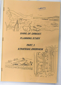
book / document, Shire of Orbost Planning Schemes March 1989, 1989
... River and Newmerella and includes urban and non-urban areas. This document is a useful reference tool. Orbost-planning A book with a brown front cover with a plastic over-sheet and plastic binding.On the cover are b/w drawings of rural landscapes, trees and the coast. It is titled SHIRE OF ORBOST PLANNING STUDY ...This document was produced in 1989 for Orbost Shire Council. It ccovers the area s of Orbost, Mallacoota, Cann River and Newmerella and includes urban and non-urban areas.This document is a useful reference tool.A book with a brown front cover with a plastic over-sheet and plastic binding.On the cover are b/w drawings of rural landscapes, trees and the coast. It is titled SHIRE OF ORBOST PLANNING STUDY Part 1 Strategic Overviews, March 1989.orbost-planning -
 Orbost & District Historical Society
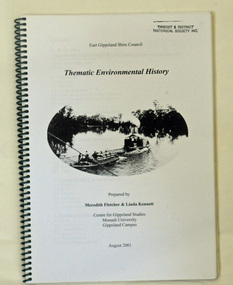
book, Thematic Environmental History, 2001
... Studies, Monash University, Gippsland Campus. On the front cover is a black and white drawing of a paddle steamer towing a barge along a river. ...Studies, Monash University, Gippsland Campus. On the front cover is a black and white drawing of a paddle steamer towing a barge along a river. ...This booklet was prepared for the East Gippsland Shire Council in August 2001.A Thematic Environmental History identifies how key patterns of development have influenced the culture of the area and the natural and built environment. The document is not a social history but usually provides the context for future heritage studies and assessments and would provide input to the preparation of a Heritage Action Plan. This booklet prepared for the East Gippsland Shire councilA spiral bound book of 75 pp, titled Thematic Environmental History, prepared by Meredith Fletcher and Linda Kennett for the Centre for Gippsland Studies, Monash University, Gippsland Campus. On the front cover is a black and white drawing of a paddle steamer towing a barge along a river. It contains information on the discovery, settlement and land usage of East Gippsland as well as the development of transport, communication and cultural institutions. Copywright held by East Gippsland Shire Council and Department of Infrastructureenvironmental-study-east-gippsland -
 Orbost & District Historical Society
folder, Daniel Moylan (Dan the Cook), October 2012
... This record is an excellent research tool for the study of the Indigenous history of Orbost. daniel-moylan aboriginal-history-orbost handwritten on a white label - Daniel Moylan handwritten on a white label below -Information researched and supplied by Mary Doland (Dan the Cook) Orbost grave Orbost station death 1851 A 38 pp black spiral bound plastic folder containing a CD and research evidence compiled by Mary Doland on the topic of Dan Moylan, known as "Dan the Cook". He was speared to death in 1851 at Orbost Station, Snowy River ...This research record was part of a thesis that Mary Doland was preparing.This record is an excellent research tool for the study of the Indigenous history of Orbost.A 38 pp black spiral bound plastic folder containing a CD and research evidence compiled by Mary Doland on the topic of Dan Moylan, known as "Dan the Cook". He was speared to death in 1851 at Orbost Station, Snowy River.handwritten on a white label - Daniel Moylan handwritten on a white label below -Information researched and supplied by Mary Doland (Dan the Cook) Orbost grave Orbost station death 1851daniel-moylan aboriginal-history-orbost -
 Eltham District Historical Society Inc
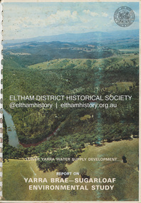
Book, Melbourne Metropolitan Board of Works, Lower Yarra Water Supply DeVelopment: Report on Yarra Brae-Sugarloaf Environmental Study, April 1974
... Study...Melbourne Metropolitan Board of Works...Report...Sugarloaf Reservoir...water catchment area...water supply...Yarra Brae Dam...Yarra River...Eltham District Historical Society Inc 728 Main Rd Eltham melbourne Environmental Study Melbourne Metropolitan Board of Works Report Sugarloaf Reservoir water catchment area water supply Yarra Brae Dam Yarra River Valley A4 x 3cm Spiral bound 1 v. ...environmental study, melbourne metropolitan board of works, report, sugarloaf reservoir, water catchment area, water supply, yarra brae dam, yarra river valley -
 Eltham District Historical Society Inc
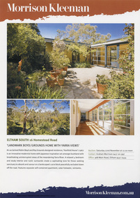
Document - Property Binder, 16 Homestead Road, Eltham, 'Handfield House'
... study was reported to be very intact. DESCRIPTION Quite advanced design, in planning and detailing. Plan U-shaped. Single and double storied; the arms of the U are basically single storied, while the base running parallel with the Yarra River is two storied. ...study was reported to be very intact. DESCRIPTION Quite advanced design, in planning and detailing. Plan U-shaped. Single and double storied; the arms of the U are basically single storied, while the base running parallel with the Yarra River is two storied. ...Contents: 1. Morrison Kleeman Sales brochure 2008 2. Newsclipping; Advertisement, Morrison Kleeman, Eltham South 16 Homestead Road, Diamond Valley Leader, November 5, 2008, p7 (on reverse, p8 Advertisement, Morrison Kleeman, Eltham 45 Lavender Park Road) Designed by Robin Boyd for friends John and Esta Handfield, Handfield House was built 1961. In a letter dated 16 May 1989 to Blanche Shallard of the Shire of Eltham Historical Society, John Handfield advised that the house was designed by their friend Robin Boyd and that it was built in 1961. As of that date they had been the only occupants. They were still the owners when the house was included in the 1992 Shire of Eltham Heritage Study The 1992 Study advised: CULTURAL SIGNIFICANCE Designed by well-known Victorian Architect Robin Boyd after he returned from lecturing architectural students in Japan, the Handfield residence shows the influence of traditional Japanese design in its modular wall arrangements, solid and glazed panels and sliding exterior doors. The courtyard planning, floor to ceiling glass walls and the combination of single and double storey sections on the steep site illustrate quite advanced dwelling design for its time. Designed to house three generations, grandparents, their children and grandchildren, the house at the time of the 1992 study was reported to be very intact. DESCRIPTION Quite advanced design, in planning and detailing. Plan U-shaped. Single and double storied; the arms of the U are basically single storied, while the base running parallel with the Yarra River is two storied. Walls timber stud framed?, asbestos cement sheet clad. Roofs flat?. Floors timber, some concrete?. Features include the modular wall design, courtyard planning, combination of single and double storey sections, internal planning and floor to ceiling glass walls. SOURCES OF INFORMATION: Information from Mr. John Handfield. CONSERVATION GUIDELINES: Keep this residence intact. Esta Handfield died in 1995 The property was sold in 1996 Property history (source realestate.com.au) 2022 – Sold $2,240,000 September 17, 2022 by Jellis Craig - Eltham 1998 – Sold $348,500 June 20, 1998 1996 – Sold $250,000 September 9, 1996 (possibly Stockdale & Leggo) The property was offered for sale in 2008 by Morrison Kleeman with a price guide of $900,00 to $990,00 but it has not been confirmed if this sale proceeded property, eltham, houses, john handfield, esta handfield, robin boyd, 16 homestead road, handfield house, 45 lavender park road -
 The Beechworth Burke Museum
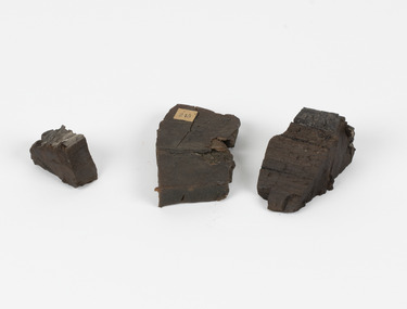
Geological specimen - Coorongite
... Many of these specimens were sent to research and collecting organisations across Australia, including the Burke Museum, to educate and encourage further study. burke museum beechwoth indigo shire beechworth museum geological geological specimen mineraology coorong coorong river kurangk ngarrindjeri south australia coorongite coorongite specimen Specimen 245 page 69 / in Descriptive Register / "Elcestic Bitumen, / Coorangite" South of / Coorung River, South Australia . / C. ...Coorongite is a dark, rubber-like, highly resilient structureless algal deposit. In the Coorong district of South Australia it occurs in moderate quantities associated with the coastal swamps and sand dunes which extend for a considerable distance east of the mouth of the Murray. This particular specimen was recovered from the south of the Coorong River, South Australia. A type of sediment rich in organic matter, Coorongite is the unlithified end-member of the sapropelic coal series. The members of the sapropelic coal series can be ranked in order as sapropel (the unlithified form), sapropelic-lignite, and sapropelic-coal (the lithified forms) based on increasing carbon content and decreasing volatile content. Sapropel (Coorongite) is an unlithified dark, pulpy, fine organic mud containing concentrations of algae and miospores that are more or less identifiable. Coorongite is typically found as an algae like substance, that can be found in irregular size pieces. Coorongite was believed to be dried up oil due to its rubber-like texture. The Coorongite is also soft to the point where it can be cut into with a knife or it can be broken and torn by hand. Otherwise known as 'Kurangk', the Coorong River is home to the Ngarrindjeri people, which acts as both a place for gathering food and a spiritual place. In 1852 the first sight of Coorongite was found along the Coorong River. The finders mistook the Coorongite for dried up oil, which lead to the belief that there were oil reserves under the Coorong River. Between the 1860s and the 1930s the Coorong River became a place where mining oil and Coorongite became precedent. Nowadays, the local council and the South Australian Government are working together with the Ngarrindjeri people to sustain and preserve the Coorong River and the culture that is with it. Soon after gold was discovered in 1851, Victoria’s Governor La Trobe wrote to the Colonial Office in London, urging ‘the propriety of selecting and appointing as Mineral Surveyor for this Colony a gentleman possessed of the requisite qualifications and acquaintance with geological science and phenomena’. Alfred Selwyn was appointed geological surveyor in Australia in 1852 which began the Geological Survey of Victoria. Selwyn went on to collect geological samples and catalogue thousands of specimens around Australia. In 1853-69 the Geological Survey issued under Selwyn's direction sixty-one geological maps and numerous reports; they were of such high standard that a writer in the Quarterly Journal of the Geological Society of London bracketed the survey with that of the United States of America as the best in the world. During his years spent in Australia, Selwyn collected numerous significant geological specimens, examples of which are held in collections such as the Burke Museum.Coorongite is considered to be a mineral with a unique texture, where it can be both hard and soft. Coorongite can also be considered to be a rare mineral, as it is only located along the Coorong River and due to the mining of it, has left very few sources. It was believed at one point that Coorongite could be used to replace oil. This specimen is part of a larger collection of geological and mineral specimens collected from around Australia (and some parts of the world) and donated to the Burke Museum between 1868-1880. A large percentage of these specimens were collected in Victoria as part of the Geological Survey of Victoria that begun in 1852 (in response to the Gold Rush) to study and map the geology of Victoria. Collecting geological specimens was an important part of mapping and understanding the scientific makeup of the earth. Many of these specimens were sent to research and collecting organisations across Australia, including the Burke Museum, to educate and encourage further study.Three solid varyingly hand-sized pieces of wooden appearing organic matter derived from the river in the Coorong District in South Australia. A rubber-like, highly resilient structureless algal deposit.Specimen 245 page 69 / in Descriptive Register / "Elcestic Bitumen, / Coorangite" South of / Coorung River, South Australia . / C. WIllman / 15/4/21burke museum, beechwoth, indigo shire, beechworth museum, geological, geological specimen, mineraology, coorong, coorong river, kurangk, ngarrindjeri, south australia, coorongite, coorongite specimen -
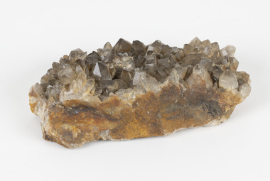 The Beechworth Burke Museum
Geological specimen - Smoky quartz crystals, unknown
... study. Geological Specimen geology Geology Collection Burke Museum Beechworth microcrystalline quartz quartz mining quartz reefs beechworth smokey quartz crystals crystals crystalline silicon oxide brown colour igneous rocks magma Ashburton river Western Australia Marlborough Queensland Lune River Tasmania Kingsgate New South Wales NSW Smoky quartz / crystals /locality/ unknown / (needs a wash) /BB A large hand-sized quartz mineral with shades of brown and gray throughout. ...Quartz is an extremely common mineral to find across the world. Quartz can have two forms; Microcrystalline quartz or Crystalline quartz. Microcrystalline quartz is a fine grain quartz where crystalline quartz is often a large crystal. This specimen is a crystalline quartz. Made of silicon oxide, this specimen is called smokey quartz crystals because of its brownish colour. However, the colour of quartz can vary. In addition, quartz are formed in deep-seated igneous rocks and crystallized through hot aqueous solutions. This type of crystal can be found all over Australia, including Beechworth in Victoria. Other places quartz can be found is the Ashburton River area in Western Australia, Marlborough in Queensland, the Lune River area in Tasmania and Kingsgate in New South Wales. This specimen is significant because it is common to find this kind of mineral. While the location of where this specimen was originally from is unknown, it highlights the many places in Australia where quartz is found. It demonstrates that quartz makes up a large portion of Australia's geology. In addition, quartz itself can vary in its colour and shape. This specimen represents one of these variations. That being smoky quartz crystals. This specimen is part of a larger collection of geological and mineral specimens collected from around Australia (and some parts of the world) and donated to the Burke Museum between 1868-1880. A large percentage of these specimens were collected in Victoria as part of the Geological Survey of Victoria that begun in 1852 (in response to the Gold Rush) to study and map the geology of Victoria. Collecting geological specimens was an important part of mapping and understanding the scientific makeup of the earth. Many of these specimens were sent to research and collecting organisations across Australia, including the Burke Museum, to educate and encourage further study.A large hand-sized quartz mineral with shades of brown and gray throughout.Smoky quartz / crystals /locality/ unknown / (needs a wash) /BBgeological specimen, geology, geology collection, burke museum, beechworth, microcrystalline, quartz, quartz mining, quartz reefs beechworth, smokey quartz crystals, crystals, crystalline, silicon oxide, brown, colour, igneous rocks, magma, ashburton river, western australia, marlborough, queensland, lune river, tasmania, kingsgate, new south wales, nsw -
 The Beechworth Burke Museum
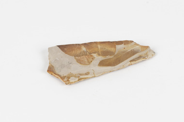
Geological specimen - Fossil Leaves
... river flood plains, ponds and lakes. This specimen is part of a larger collection of geological and mineral specimens collected from around Australia (and some parts of the world) and donated to the Burke Museum between 1868-1880. A large percentage of these specimens were collected in Victoria as part of the Geological Survey of Victoria that begun in 1852 (in response to the Gold Rush) to study and map the geology of Victoria. ...A fossil refers to any remains or traces of past life that are preserved in the rock. It could be remains of plants or animals. Fossil leaves are commonly found on different types of rocks. These fossils can go as far back as the Triassic Age just like the series of fossil plants collected at Denmark Hill, Ipswich in Queensland. Fossils leaves are formed when dead plants get buried by sediments like mud, sand, or volcanic ash. Often, it gets detached cleanly from stems along a special layer of weak cells, then twigs, and, less commonly, cones of conifers and fruits and seeds of flowering plants. Over time, the leaves or pieces of leaves get buried by more sediments and eventually gets 'lithified' or hardened into a rock. Erosions and mining can cause the rocks to break and reveal the fossils buried in it. Fossilisation frequently takes place at sites in the lowlands where deposits of clay, silt, sand are found. This is usually due to weathering and erosion of rocks. Fossil leaves can provide information about ancient Australia's way of living. It contributes to Victorian biodiversity records and its botanical collections. It also contributes information on the geographical profile of Victoria as fossilisation usually occur at estuaries and deltas of rivers, river flood plains, ponds and lakes. This specimen is part of a larger collection of geological and mineral specimens collected from around Australia (and some parts of the world) and donated to the Burke Museum between 1868-1880. A large percentage of these specimens were collected in Victoria as part of the Geological Survey of Victoria that begun in 1852 (in response to the Gold Rush) to study and map the geology of Victoria. Collecting geological specimens was an important part of mapping and understanding the scientific makeup of the earth. Many of these specimens were sent to research and collecting organisations across Australia, including the Burke Museum, to educate and encourage further study.Piece of light brown rock with fossilised leaves in shades of golden yellow and brown.Existing label: Fossil Leaves / Locality unknown / might be worth checking if this is Glossopteris, a Permian age plant. / C. William 16/4/21 geological specimen, geology, geology collection, burke museum, beechworth, fossil leaves, fossilization, 1868 geological survey of victoria, lithified, rocks, fossilised leaf, rock, fossils, leaves -
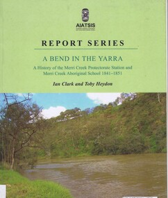 Greensborough Historical Society
Book, Ian D. Clark et al, A Bend in the Yarra: a history of the Merri Creek protectorate Station and Merri Creek Aboriginal School 1841-1851, by Ian D. Clark and Toby Heydon, 2004_
... Greensborough Historical Society 34A Glenauburn Road Lower Plenty Lower Plenty melbourne A history of Aboriginal cultural institutions in colonial Victoria, in this book the interaction between Wurundjeri people and government officials and settlers at the confluence of the Merri Creek and Yarra River. merri creek aborigines victoria Paperback book, 90 p. black & white illus A Bend in the Yarra: a history of the Merri Creek protectorate Station and Merri Creek Aboriginal School 1841-1851, by Ian D. Clark and Toby Heydon Book Ian D. Clark Toby Heydon Aboriginal Studies ...A history of Aboriginal cultural institutions in colonial Victoria, in this book the interaction between Wurundjeri people and government officials and settlers at the confluence of the Merri Creek and Yarra River.Paperback book, 90 p. black & white illusmerri creek, aborigines victoria -
 Greensborough Historical Society
Photographs, Photographs by Maria Barbaro, 2009_
... studies for her paintings. Taken in the Greensborough area, photos cover a wide range of natural and built landscapes, including the Plenty River; parks and gardens; the Greensborough Hotel; Ashmead; Greensborough railway station....studies for her paintings. Taken in the Greensborough area, photos cover a wide range of natural and built landscapes, including the Plenty River; parks and gardens; the Greensborough Hotel; Ashmead; Greensborough railway station. ...A collection of over 170 photographs taken by artist Maria Barbaro as studies for her paintings. Taken in the Greensborough area, photos cover a wide range of natural and built landscapes, including the Plenty River; parks and gardens; the Greensborough Hotel; Ashmead; Greensborough railway station.A variety of photographs of the Greensborough area in the early 21st Century.Folder containing approx 150 colour photographs of Greensborough area. Each photograph 10x15cmmaria barbaro, greensborough -
 Greensborough Historical Society
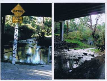
Document - Document Collection, Allom Lovell & Associates, Old Lower Plenty Bridge, 2001
... Heritage citation for the Old Lower Plenty Bridge, copied from Banyule Heritage Places Study; a short history of the bridge and a news clipping, dated 2001 reporting on the re-opening of the bridge as a link in the Plenty River Trail....Greensborough Historical Society 34A Glenauburn Road Lower Plenty Lower Plenty melbourne Heritage citation for the Old Lower Plenty Bridge, copied from Banyule Heritage Places Study; a short history of the bridge and a news clipping, dated 2001 reporting on the re-opening of the bridge as a link in the Plenty River Trail. plenty river plenty river trail old lower plenty bridge lower plenty 4 p., illus. ...Heritage citation for the Old Lower Plenty Bridge, copied from Banyule Heritage Places Study; a short history of the bridge and a news clipping, dated 2001 reporting on the re-opening of the bridge as a link in the Plenty River Trail.4 p., illus. Heritage citation, 2p.; history of bridge, 1p.; newspaper clipping, 1p. plenty river, plenty river trail, old lower plenty bridge, lower plenty -
 Greensborough Historical Society
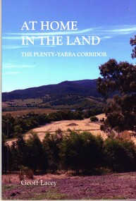
Book, Geoff Lacey, At home in the land: the Plenty-Yarra corridor, 2021
... An ecological study of the the landscape along the corridors of the Plenty and Yarra rivers, their history, development and conservation....Greensborough Historical Society 34A Glenauburn Road Lower Plenty Lower Plenty melbourne An ecological study of the the landscape along the corridors of the Plenty and Yarra rivers, their history, development and conservation. indigenous plants indigenous fauna plenty river yarra river 111 p., paperback, col. photographs, maps At home in the land: the Plenty-Yarra corridor Book Book Geoff Lacey ...111 p., paperback, col. photographs, mapsnon-fictionindigenous plants, indigenous fauna, plenty river, yarra river -
 Greensborough Historical Society
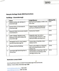
Document - Submission, Anne Paul et al, Banyule Heritage Study 2020 Nominations: Buildings - Greensborough, 2020
... Study 2020 by Norm Colvin and Anne Paul on behalf of the Greensborough Historical Society. Buildings include: Stubley building, Genista house, Diamond Valley Community Hospital, Lobb's Cottage, Old Baptist church, railway electrical buildings, swimming pool in Plenty River at Greensborough....Study 2020 by Norm Colvin and Anne Paul on behalf of the Greensborough Historical Society. Buildings include: Stubley building, Genista house, Diamond Valley Community Hospital, Lobb's Cottage, Old Baptist church, railway electrical buildings, swimming pool in Plenty River at Greensborough. historic buildings banyule heritage study 2020 greensborough 8 p., text and colour photographs. ...Descriptions and photographs of seven early building of historical interest in Greensborough, nominated for the Banyule Heritage Study 2020 by Norm Colvin and Anne Paul on behalf of the Greensborough Historical Society. Buildings include: Stubley building, Genista house, Diamond Valley Community Hospital, Lobb's Cottage, Old Baptist church, railway electrical buildings, swimming pool in Plenty River at Greensborough.8 p., text and colour photographs.historic buildings, banyule heritage study 2020, greensborough -
 Greensborough Historical Society
Document - Submission, Norm Colvin et al, Banyule Heritage Study 2020 Nominations - Plenty River railway bridge Greensborough, 2020
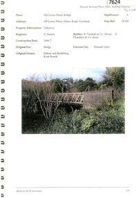
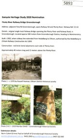
... Banyule Heritage Study 2020 Nominations - Plenty River railway bridge Greensborough. ...river...banyule heritage study 2020...Part of the single track railway extension of 1902 from Heidelberg to Eltham, the Plenty River railway bridge Greensborough, was nominated for the Banyule Heritage Study 2020. ...This nomination was prepared by Norm Colvin & Anne Paul on behalf of the Greensborough Historical Society hurstbridge rail line plenty river banyule heritage study 2020 1 p. Text and photographs Banyule Heritage Study 2020 Nominations - Plenty River railway bridge Greensborough. ...Part of the single track railway extension of 1902 from Heidelberg to Eltham, the Plenty River railway bridge Greensborough, was nominated for the Banyule Heritage Study 2020. This nomination was prepared by Norm Colvin & Anne Paul on behalf of the Greensborough Historical Society1 p. Text and photographshurstbridge rail line, plenty river, banyule heritage study 2020 -
 Greensborough Historical Society
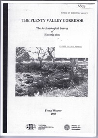
Book, The Plenty Valley Corridor: the archaelogical survey of historic sites, by Fiona Weaver, for the Ministry of Planning & Environment, 1989_
... The study was intended to provide a brief history of Aboriginal and European occupation and use of the area and an outline of the geography of the chief areas of cultural heritage concern, with recommendations for protection of significant cultural sites and recommendations for further research, survey and consultation. plenty river fiona weaver victorian archaeological survey 115 p., photocopy, unbound. ...The Victorian Archaelogical Survey managed this study onbehalf of the Ministry for Planning & Environment. The study was intended to provide a brief history of Aboriginal and European occupation and use of the area and an outline of the geography of the chief areas of cultural heritage concern, with recommendations for protection of significant cultural sites and recommendations for further research, survey and consultation.115 p., photocopy, unbound. Illus., mapsplenty river, fiona weaver, victorian archaeological survey -
 Mission to Seafarers Victoria
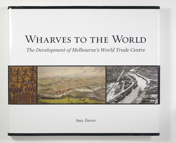
Book - Reference book, Melbourne Books, Wharves To The World: The Development Of Melbourne's World Trade Centre, 2011
... study at the University of Melbourne. After being recommended by the university, she was taken on as a full-time historian by Asset1 World Trade Centre (WTC). Her work focuses on the WTC, the Yarra River...study at the University of Melbourne. After being recommended by the university, she was taken on as a full-time historian by Asset1 World Trade Centre (WTC). Her work focuses on the WTC, the Yarra River ...Wharves to the World: The Development of Melbourne's World Trade Centre is a photographic chronicle of the history of the World Trade Centre and its surrounds. The book traces the journey of land and the buildings that occupied it - from its beginnings with the Wurundjeri people to its role as a trading hub in early Melbourne, then as the site of the modern-day World Trade Centre, and now as part of a flourishing residential and commercial Precinct. As with any major project The World Trade Centre has face its share of fêlures, but despite thèse it has become an integral part of the City. So it goes that was once home to swampland and the City morgue has been transformer into a Diamond of the Yarra River.A 128-page book of printed matter, photographs, engravings and drawings. The hard cover is white with the title in gold lettering on the front. The dust-cover is also white with black lettering. Along the lower half of the cover, front and back, is a strip of six photos, three coloured and three black and white. 128 p. : ill. (some col.), ports. non-fictionWharves to the World: The Development of Melbourne's World Trade Centre is a photographic chronicle of the history of the World Trade Centre and its surrounds. The book traces the journey of land and the buildings that occupied it - from its beginnings with the Wurundjeri people to its role as a trading hub in early Melbourne, then as the site of the modern-day World Trade Centre, and now as part of a flourishing residential and commercial Precinct. As with any major project The World Trade Centre has face its share of fêlures, but despite thèse it has become an integral part of the City. So it goes that was once home to swampland and the City morgue has been transformer into a Diamond of the Yarra River.yarra yarra tribe, early melbourne, world trade centre, melbourne, southbank, northbank, australian wharf, siddeley street, waterfront, amy zurrer, wurundjeri, spencer street bridge, north wharf, riverlee, wtc, wharf, harbor trust, sir john coode, harbour trust, little dock, polly woodside, wharfies, divers -
 Eltham District Historical Society Inc
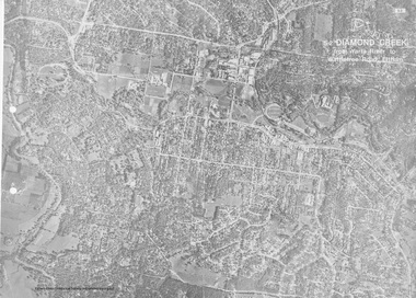
Work on paper (Sub-Item) - Aerial Photograph, Diamond Creek from Yarra River to Wattletree Road, Eltham
... Eltham District Historical Society Inc 728 Main Rd Eltham melbourne Black and white aerial photograph witrh key features around the central place of Eltham township marked inluding Yarra River, Main Road, Bridge Street and Ryans Road, Eltham North land development real estate aerial view Eltham Eltham North Image printed on foldout A3 page from 04997 Diamond Creek Basin Study, 1980 Diamond Creek from Yarra River to Wattletree Road, Eltham Work on paper Aerial Photograph ...Black and white aerial photograph witrh key features around the central place of Eltham township marked inluding Yarra River, Main Road, Bridge Street and Ryans Road, Eltham North land development, real estate, aerial view, eltham, eltham north