Showing 39 items matching "rocky valley dam"
-
 Kiewa Valley Historical Society
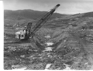
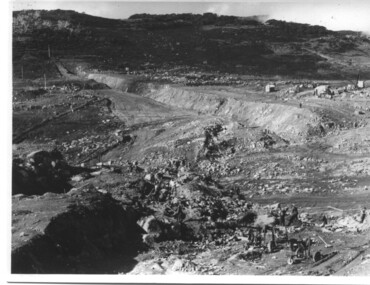
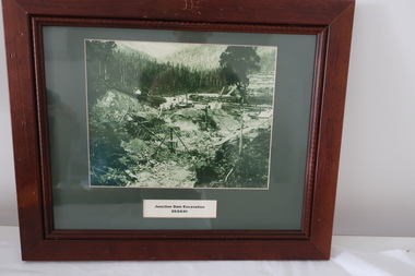
Photograph Rocky Valley Dam Excavations, Rocky Valley Dam Wall Excavation, c1947-48
... Photograph Rocky Valley Dam Excavations...Rocky Valley Dam Wall Excavation...rocky valley...dam...Work commenced at Rocky Valley Dam site in early 1947 and proceeded until May. ...Black and white photograph of Rocky Valley Dam wall under construction. There are at least three cranes plus workmen in the photo. ...Hand written on back of photograph "Rocky Valley Dam Wall Excavation" in blue ink....This is taken from the Heathey's Spur side of the dam wall looking back toward Sun Valley. Rocky Valley Dam Wall Excavation Photograph Rocky Valley Dam Excavations Photograph probably taken by Mr. ...Work commenced at Rocky Valley Dam site in early 1947 and proceeded until May. Resumed work in October after the winter and a camp for the accommodation of workmen was commenced at this time. Work continued in 1948 with the establishment of work facilities, including the erection of two large excavators. At the dam site the river was diverted through a temporary pipeline. Work proceeded in the summer months with the placing of concrete in the foundations and earth and rock fill for the construction of the wall. Rocky Valley and associated spillway and outlet works were completed in March, 1959. A very good representation of the type of machinery available in the 1940's used for excavation of the dam and the construction of the dam wall.Black and white photograph of Rocky Valley Dam wall under construction. There are at least three cranes plus workmen in the photo. This is taken from the Heathey's Spur side of the dam wall looking back toward Sun Valley.Hand written on back of photograph "Rocky Valley Dam Wall Excavation" in blue ink.rocky valley, dam, wall, machinery -
 Falls Creek Historical Society
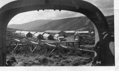
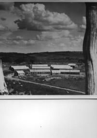
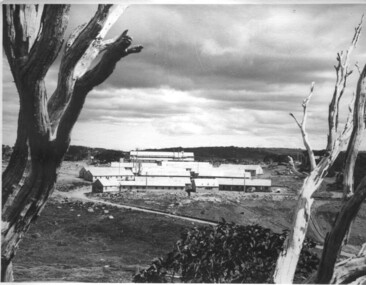
Photograph - Building Rocky Valley Dam Wall
... Building Rocky Valley Dam Wall...Building Rocky Valley Dam Wall...Rocky Valley Dam...The Rocky Valley Dam is located on the Bogong High Plains, near Falls Creek, Victoria. ...Three black and white images showing work on the Rocky Valley Dam, Victoria...Falls Creek Historical Society Slalom Street Falls Creek The Rocky Valley Dam is located on the Bogong High Plains, near Falls Creek, Victoria. ...The Rocky Valley Dam is located on the Bogong High Plains, near Falls Creek, Victoria. The dam is man-made and has a capacity of 28,000 megalitres (990×106 cu ft). At an elevation of 1600m, Rocky Valley Dam is the highest significant body of water in Australia. The dam was created for the Kiewa Hydroelectric Scheme. Just a short distance from the heart of the village, the lake provides a playground for a range of aquatic activities. It is also utilised in snow making for the Falls Creek ski resort. Work began on the Rocky Valley Dam site in early 1947 and continued until May. It resumed in October after the winter and a camp for the accommodation of workmen was commenced at this time. Work continued in 1948 with the establishment of work facilities, including the erection of two large excavators. The Rocky Valley Dam was completed in 1959.These images are significant as they capture work carried out to build the wall at Rocky Valley near Falls Creek, VictoriaThree black and white images showing work on the Rocky Valley Dam, Victoriarocky valley dam, kiewa hydroelectric scheme, falls creek -
 Falls Creek Historical Society
Postcard - Sun Valley, Looking to Rocky Valley Dam
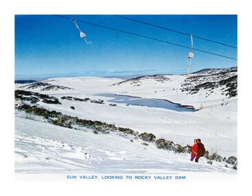
... Sun Valley, Looking to Rocky Valley Dam...Sun Valley, Looking to Rocky Valley Dam......Rocky Valley Dam...A high definition photo of the skiers at Sun Valley with Rocky Valley Dam in the background. Rocky Valley Dam is man-made and has a capacity of 28,000 megalitres. ...Sun Valley, Looking to Rocky Valley Dam Postcard Sun Valley, Looking to Rocky Valley Dam ...These photographs were taken in and around Falls Creek by Samuel Keith Pearce and printed for him as a foldout postcard by NuColor Vue. The postcards state they were printed for S. K. Pearce Pty. Ltd of Tawonga and Mount Beauty. Samuel Keith Pearce was born on 24 June 1917 in Armadale, Victoria. By the late 1940s he owned the Mt Beauty Supermarket, Newsagency, Drapery and Hardware store at Mount Beauty and also a store at Tawonga in partnership with his brother Gordon Cathew Pearce. For some time, they operated as Pearce Brothers. In the early 1960s Keith also opened a mini mart In Falls Creek. As well as being a keen photographer and an astute businessman, Keith Pearce was a well-known identity in the Kiewa Valley, making many contributions to the development of the area over a long period. This included serving as a member of the Bright Shire Council for many years. He worked hard to promote the interests of the Upper Kiewa Valley. As a sign of recognition and appreciation for his contribution to the community, the park opposite the grocery store in Mount Beauty was named the SK Pearce Gardens in his honour. Samuel Keith Pearce died on 7 July 1994 in Mount Beauty, VictoriaThis collection of postcards and image is significant because they were commissioned by a highly successful business in Falls Creek, Victoria.A high definition photo of the skiers at Sun Valley with Rocky Valley Dam in the background. Rocky Valley Dam is man-made and has a capacity of 28,000 megalitres. It was created for the Kiewa Hydroelectric Scheme and is also utilised in snow making for Falls Creek.falls creek resort, sun valley tow, rocky valley dam, hydroelectricity -
 Kiewa Valley Historical Society
Photograph - Parlimentary Party visiting Rocky Valley Dam site, 15-4-1948
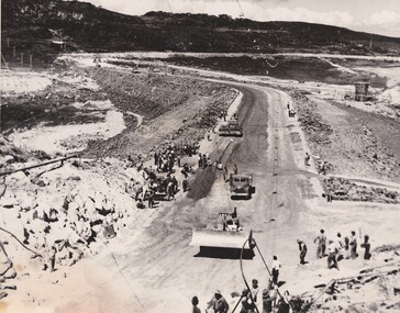
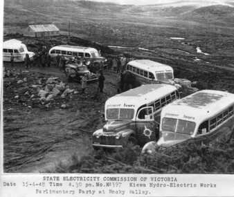
... Photograph - Parlimentary Party visiting Rocky Valley Dam site...Rocky Valley Dam...This photograph was taken during construction of the Rocky Valley Dam and wall. Work was commenced in early 1947 but had to be suspended during winter and then resumed in October. ...Photocopy of black and white photograph of parliamentary party visiting Rocky Valley Dam site 15/04/1948...Parlimentary Party at Rocky Valley Photocopy of black and white photograph of parliamentary party visiting Rocky Valley Dam site 15/04/1948 Photograph - Parlimentary Party visiting Rocky Valley Dam site ...This photograph was taken during construction of the Rocky Valley Dam and wall. Work was commenced in early 1947 but had to be suspended during winter and then resumed in October. Work continued in 1948 with the establishment of work facilities and, at the dam site, the river was diverted through a temporary pipeline. Rocky Valley and associated spillway and outlet works were completed in 1959.A pictorial record of the construction of the rock and earth filled dam wall at Rocky Valley. Shows the extent of the project undertaken and the level of importance of the project as indicated by the large representation at the parliamentary party visit on 15/4/48.Photocopy of black and white photograph of parliamentary party visiting Rocky Valley Dam site 15/04/1948Typed on the bottom of photocopy - State Electricity Commission of Victoria. Date: 15-4-48 Time: 4.30pm No: K4397. Kiewa Hydro-Electric works. Parlimentary Party at Rocky Valleyrocky valley dam, parliamentary party, secv -
 Kiewa Valley Historical Society
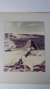
Photo - Rocky Valley Dam
... Photo - Rocky Valley Dam...Rocky Valley Dam...The scheme consisted of storage dams and pondages, aqueducts, tunnels, pipelines, transmission lines and three power stations.. Rocky Valley dam was the biggest storage and the last to be completed....The background shows hills and the foreground a sign "Rocky Valley Dam ..." The middle shows the dam with water and its bank. ...There is snow on the ground. Photo - Rocky Valley Dam ...The State Electricity Commission of Victoria constructed the Kiewa Hydro Electric Scheme on the Bogong High Plains. The scheme consisted of storage dams and pondages, aqueducts, tunnels, pipelines, transmission lines and three power stations.. Rocky Valley dam was the biggest storage and the last to be completed.Rocky Valley dam was the largest storage within the Kiewa Hydro Electric Scheme. Begun in 1954 and completed in 1960. It was linked to McKay Creek Power StationColoured photo attached to cream cardboard. The background shows hills and the foreground a sign "Rocky Valley Dam ..." The middle shows the dam with water and its bank. There is snow on the ground.rocky valley dam, kiewa hydro electric scheme, secv -
 Kiewa Valley Historical Society
Photograph of Rocky Valley, Rocky Valley showing Dam Excavation, c1948-1951
... Rocky Valley showing Dam Excavation...rocky valley...dam...This photograph was taken during construction of the Rocky Valley Dam and wall. Work was commenced in early 1947 but had to be suspended during winter and then resumed in October. ...A black and white photograph showing the excavation of the dam at Rocky Valley looking towards Heathey's Spur...Hand written on the back of photograph in blue ink "Rocky Valley showing dam excavation" ...A pictorial record of the construction of the rock and earth filled dam wall at Rocky Valley. Shows the extent of the project undertaken and the fact that a lot of the work was done manually by pick and shovel - note the workmen using picks and sledge hammers on the lower half of the photo. rocky valley dam wall picks sledge hammers Hand written on the back of photograph in blue ink "Rocky Valley showing dam excavation" A black and white photograph showing the excavation of the dam at Rocky Valley looking towards Heathey's Spur Rocky Valley showing Dam Excavation Photograph of Rocky Valley Photograph probably taken by Mr. ...This photograph was taken during construction of the Rocky Valley Dam and wall. Work was commenced in early 1947 but had to be suspended during winter and then resumed in October. Work continued in 1948 with the establishment of work facilities and, at the dam site, the river was diverted through a temporary pipeline. Rocky Valley and associated spillway and outlet works were completed in 1959.A pictorial record of the construction of the rock and earth filled dam wall at Rocky Valley. Shows the extent of the project undertaken and the fact that a lot of the work was done manually by pick and shovel - note the workmen using picks and sledge hammers on the lower half of the photo.A black and white photograph showing the excavation of the dam at Rocky Valley looking towards Heathey's SpurHand written on the back of photograph in blue ink "Rocky Valley showing dam excavation" rocky valley, dam, wall, picks, sledge hammers -
 Kiewa Valley Historical Society
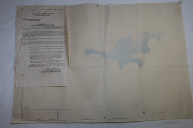
Plan Ref. K. 6612 with Letter attached re Public Safety in Kiewa Works Area
... Rocky Valley Dam...The SECV constructed the Kiewa Hydro Electric Scheme which included the building of Rocky Valley Dam on the Bogong High Plains near Falls Creek. ...K 6612 of Fall Creek showing Rocky Valley Dam's shape when it is full. Letter dated 6th April 1959 from H.H.C. ...K 6612 of Fall Creek showing Rocky Valley Dam's shape when it is full. Letter dated 6th April 1959 from H.H.C. ...The SECV constructed the Kiewa Hydro Electric Scheme which included the building of Rocky Valley Dam on the Bogong High Plains near Falls Creek. H.H.C. Williams, construction engineer, Kiewa wrote to the Ski Clubs at Falls Creek outlining the dangers arising with the filling of Rocky Valley Dam. He lists 5 warnings in the interest of safety.The plan and letter provide the dates for the completion of Rocky Valley dam and its effect on the people living and working in the area including miners and ski clubs. It describes some of the features of Kiewa Works Area at the time.Plan No. K 6612 of Fall Creek showing Rocky Valley Dam's shape when it is full. Letter dated 6th April 1959 from H.H.C. Williams to Ski Clubs at Falls Creek re public safety as Rocky Valley fills. Refers to roads, transmission lines, pole lines etc in the Kiewa Works Area.Written in ink at top of letter - "Secretary / Mt Beauty and District Progress Association"rocky valley dam, falls creek ski clubs, h.h.c. williams, khes 1959, safety -
 Falls Creek Historical Society
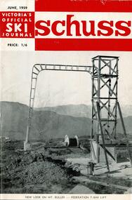
Journal - Schuss Vol. 25. No 4 June 1959
... ...Rocky Valley Dam...Page 39 included news about the completion of the Rocky Valley Dam which was now filling. It outlined safety warnings from the State Electricity Commission. ...Schuss journal Rocky Valley Dam Falls Creek Committee of Management The journal includes stories and events chronicling developments in Victoria and internationally. ...Schuss was advertised as Victoria’s Official Ski Journal It was issued monthly from 1935 to 1961 except during the war when summer issues covered two months. This continued after the war, but it averaged 10 issues annually over its 25 year life. Schuss was published by the Ski Club of Victoria which had a membership of 38 Ski Clubs and demanded to be recognised as the prime authority on skiing in the state. The other 30 ski clubs with 85% of the members disagreed and the politics of skiing became heated. These clubs formed the Federation of Victorian Ski Clubs with their own journal, Ski Horizon. With the establishment of the Victorian Ski Association, Ski-Horizon published its last issue in Nov - Dec. 1955 and the role of the official journal was fully taken over by “Schuss”. This item is significant because it contains stories, images and information documenting the development of the ski facilities at Falls Creek.The journal includes stories and events chronicling developments in Victoria and internationally. The cover features a photo of the new Federation T-Bar Lift at Mt. Buller. Page 39 included news about the completion of the Rocky Valley Dam which was now filling. It outlined safety warnings from the State Electricity Commission. It also announced the formation of a Management Committee for Falls Creek due to its growing popularity as an Alpine ski resort.schuss journal, rocky valley dam, falls creek committee of management -
 Kiewa Valley Historical Society
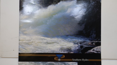
Booklet - Southern Hydro, Southern Hydro
... secv; khes; mckay creek power station; clover power station; west kiewa power station; mount beauty; rocky valley dam;...The change of ownership of hydro power from a government body to private enterprise in the late 1990s is of significant interest to the historian and consumer. secv; khes; mckay creek power station; clover power station; west kiewa power station; mount beauty; rocky valley dam; Top right hand corner of page 5 has a piece of tape stuck over the print with "Page 11 to photo copy & enlarge" Colored photo water spraying onto rocks with black strip across the bottom and logo (4 gold lines forming an "S", a blue triangle with grey cylinder beneath) of Southern Hydro within the strip. ...Southern Hydro Ltd. was established in the late 1990s as a result of the disaggregation of the former State Electricity Commission of Victoria. It operates 10 power stations mainly in the north-east of VictoriaSouthern Hydro continued to encourage tourism as did the former State Electricity Commission of Victoria. This brochure is very similar to one previously published by the SECV "Victoria's Hydro Power" except only including those that it operates. Within the KHES the power stations were McKay Creek, Clover and West Kiewa. The change of ownership of hydro power from a government body to private enterprise in the late 1990s is of significant interest to the historian and consumer.Colored photo water spraying onto rocks with black strip across the bottom and logo (4 gold lines forming an "S", a blue triangle with grey cylinder beneath) of Southern Hydro within the strip. Back cover has a similar photo with 4 small photos of men inserted in the black column. This 23 page book gives a history of Southern Hydro and its 10 hydro-electric power stations that it operates. The book lists these and gives a description of each.Top right hand corner of page 5 has a piece of tape stuck over the print with "Page 11 to photo copy & enlarge" secv; khes; mckay creek power station; clover power station; west kiewa power station; mount beauty; rocky valley dam; -
 Kiewa Valley Historical Society
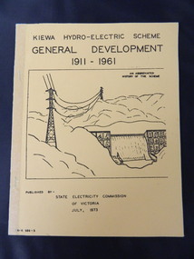
Book - Kiewa Hydro Electric Scheme 1911-1961, Kiewa Hydro-Electric Scheme /General Development / 1911-1961, July, 1973
... kiewa hydro electric scheme. mt beauty. dederang. bogong. mckay creek power station. west kiewa power station. clover power station. secv. rocky valley dam. flora. fauna. geology....The newspaper cutting gives additional information about Rocky Valley Dam. kiewa hydro electric scheme. mt beauty. dederang. bogong. mckay creek power station. west kiewa power station. clover power station. secv. rocky valley dam. flora. fauna. geology. ...The book is an abbreviated history of the Kiewa Hydro Electric Scheme.This book summarises the stages of the Kiewa Hydro Electric Scheme from its conception in 1911 through to 1961. The newspaper cutting gives additional information about Rocky Valley Dam.Yellow cardboard book with front cover of black writing and sketch of power lines and spillway in the mountains. 2 staples are covered along the spine with tape. There are 22 pages. 2 copies Inside one copy there is a newspaper cutting entitled "Main Dam in Kiewa Scheme Finished" and later published pages of 1. Floras of Bogong 2. Geology of Kiewa Area 3. Fauna and 4. 'Brief history of the Kiewa Scheme. An abbreviated History of the SchemeOn the newspaper cutting hand written "Burnett 1959 Later than May."kiewa hydro electric scheme. mt beauty. dederang. bogong. mckay creek power station. west kiewa power station. clover power station. secv. rocky valley dam. flora. fauna. geology. -
 Kiewa Valley Historical Society
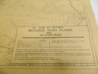
Map - Topographical, Ski Club of Victoria Bogong High Plains and Adjacent Peaks, Early 1930's
... Rocky Valley Dam (Kiewa Hydro Electric Scheme) has been drawn on the map by hand with a biro. ...It is historically significant as these people were involved in taking cattle up to the High Plains during summer and may have been used for bush walking and skiing. topographic map; kiewa valley; ryder family; high plains of victoria Rocky Valley Dam (Kiewa Hydro Electric Scheme) has been drawn on the map by hand with a biro. ...This map has been in the Ryder family for approx. 70 years. Probably used when bush walking and skiing in the early days on the Bogong High Plains. The Ryder family are farmers in the Kiewa Valley and were involved in taking their cattle up to the Bogong High Plains where they had a lease. The State Electricity Commission of Victoria constructed the Kiewa Hydro Electric Scheme opening up the area during the 1940's and 1950's. This type of map is an early one, used by people in the Kiewa Valley and possibly by surveyors prior to construction.The map is an early topographic map used by farmers living in the Kiewa Valley. It is historically significant as these people were involved in taking cattle up to the High Plains during summer and may have been used for bush walking and skiing.This is a sepia coloured paper map which was originally printed copyright registered. It was revised in 20/6.33/4.4.37/8.4.40/24.8.43/19/6/54. It shows roads / tracks / snow poles / snow pole numbers (27) / Snow pole spacing (3 chains. 66 yards) approximately 27 poles to the mile / height above sea level in feet - 5280. Water courses not definitely located etc.Rocky Valley Dam (Kiewa Hydro Electric Scheme) has been drawn on the map by hand with a biro. There is a wooden rod at the top of the map.topographic map; kiewa valley; ryder family; high plains of victoria -
 Falls Creek Historical Society
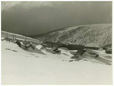
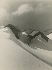
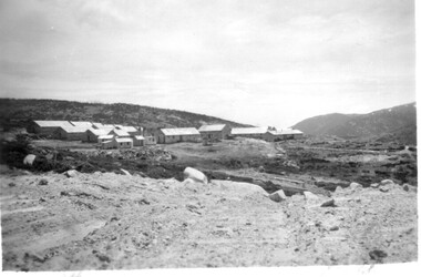
Photograph - Rocky Valley Camp
... A black and white image of Rocky Valley Camp. Work began on the Rocky Valley Dam site in early 1947 and continued until May. ...Ray Meyer Blairs Hut Falls Creek Victorian Snowfields A black and white image of Rocky Valley Camp. Work began on the Rocky Valley Dam site in early 1947 and continued until May. ...MEYER COLLECTION - FALLS CREEK PHOTOS In 1947 a determined group of like-minded State Electricity Commission (SEC) staff including Ray Meyer, the chief surveyor of the Kiewa Hydro-Electric Scheme, had a common interest that revolved around the skiing potential of the snow-covered high plains which included what is now the resort of Falls Creek. The six SEC employees, Toni St Elmo, Ray Meyer, Jack Minogue, Lloyd Dunn, Adrian Ruffenacht and Dave Gibson (together with their families) banded together to secretly build a 'hut' that was the first ski lodge at Falls Creek. Using a road built in 1930s to gain access to Falls Creek, their hut project was carried out in secret as efforts by other skiers were blocked by H.H.C. Williams – the engineer in charge of the Hydro Scheme. In 1946 Ray Meyer made a trip to the Lands Office in Melbourne. He came away with a 99-year lease on three acres that was ideally suited for a hut designed by Lloyd Dunn. Adrian Ruffenacht (Design Engineer for the KHS) had suggested where the group should build because of easy access to a spring for water. Much of the building material required was scavenged from derelict huts on the high plains. Due to the need for secrecy, the determined group worked on the hut in the evenings and weekends to avoid detection. During the building period the group had met at Echidna Rock (now known as Eagle Rock) where Skippy St Elmo announced, "This is my favourite ‘Skyline’.” And so the first lodge in the area at Falls Creek Ski Resort came into existence. With the development of the International Poma in the 1970s, the Skyline Lodge, which was sited between the ski-lift’s pole one and pole two, was demolished. However, the legacy of Ray Meyer, Toni St Elmo, Jack Minogue, Lloyd Dunn, Adrian Ruffenacht and Dave Gibson and Skyline lives on in the vibrant atmosphere of Falls Creek Resort. The MEYER COLLECTION documents developments on the Kiewa Hydro Scheme and their life at Falls Creek from the mid 1930s to 1960s.This image is significant because it documents the development of the Kiewa Hydroelectric Scheme.A black and white image of Rocky Valley Camp. Work began on the Rocky Valley Dam site in early 1947 and continued until May. It resumed in October after the winter and a camp for the accommodation of workmen was commenced at this time. Work continued in 1948 with the establishment of work facilities, including the erection of two large excavators. The Rocky Valley Dam was completed in 1959.ray meyer, blairs hut, falls creek, victorian snowfields -
 Falls Creek Historical Society
Photograph - Rocky Valley Camp
... A black and white image of Rocky Valley Camp. Work began on the Rocky Valley Dam site in early 1947 and continued until May. ...Falls Creek Victorian Snowfields Rocky Valley Camp A black and white image of Rocky Valley Camp. Work began on the Rocky Valley Dam site in early 1947 and continued until May. ...MEYER COLLECTION - FALLS CREEK PHOTOS In 1947 a determined group of like-minded State Electricity Commission (SEC) staff including Ray Meyer, the chief surveyor of the Kiewa Hydro-Electric Scheme, had a common interest that revolved around the skiing potential of the snow-covered high plains which included what is now the resort of Falls Creek. The six SEC employees, Toni St Elmo, Ray Meyer, Jack Minogue, Lloyd Dunn, Adrian Ruffenacht and Dave Gibson (together with their families) banded together to secretly build a 'hut' that was the first ski lodge at Falls Creek. Using a road built in 1930s to gain access to Falls Creek, their hut project was carried out in secret as efforts by other skiers were blocked by H.H.C. Williams – the engineer in charge of the Hydro Scheme. In 1946 Ray Meyer made a trip to the Lands Office in Melbourne. He came away with a 99-year lease on three acres that was ideally suited for a hut designed by Lloyd Dunn. Adrian Ruffenacht (Design Engineer for the KHS) had suggested where the group should build because of easy access to a spring for water. Much of the building material required was scavenged from derelict huts on the high plains. Due to the need for secrecy, the determined group worked on the hut in the evenings and weekends to avoid detection. During the building period the group had met at Echidna Rock (now known as Eagle Rock) where Skippy St Elmo announced, "This is my favourite ‘Skyline’.” And so the first lodge in the area at Falls Creek Ski Resort came into existence. With the development of the International Poma in the 1970s, the Skyline Lodge, which was sited between the ski-lift’s pole one and pole two, was demolished. However, the legacy of Ray Meyer, Toni St Elmo, Jack Minogue, Lloyd Dunn, Adrian Ruffenacht and Dave Gibson and Skyline lives on in the vibrant atmosphere of Falls Creek Resort. The MEYER COLLECTION documents developments on the Kiewa Hydro Scheme and their life at Falls Creek from the mid 1930s to 1960s.This image is significant because it depicts aspects of the development of the Kiewa Hydroelectric Scheme.A black and white image of Rocky Valley Camp. Work began on the Rocky Valley Dam site in early 1947 and continued until May. It resumed in October after the winter and a camp for the accommodation of workmen was commenced at this time. Work continued in 1948 with the establishment of work facilities, including the erection of two large excavators. The Rocky Valley Dam was completed in 1959.falls creek, victorian snowfields, rocky valley camp -
 Kiewa Valley Historical Society
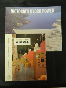
Booklets - Kiewa Hydro Electric Scheme, 1. "Power From Kiewa" and 2. "Victoria's Hydro Power", 1. Made in July 1968 and 2. Made in Aug. 1985
... Colored soft cover with Rocky Valley Dam on the front and inserted photo of a stream and snow on the back. ...Colored soft cover with Rocky Valley Dam on the front and inserted photo of a stream and snow on the back. ...1. The State Electricity Commission of Victoria built the Kiewa Hydro Electric Scheme from the 1930's to the 1960's. This booklet was to inform visitors and to promote tourism. 2. The State Electricity Commission built several hydro power stations from 1928 - 1981. This booklet names each with a summary and explanation.The State Electricity Commission of Victoria built the Kiewa Hydro Electric Scheme establishing infrastructure such as the Bogong and Mt Beauty townships and the opportunity for tourism in the area.1. Colored soft cover with photo of McKay Creek Power Station on the front and Mt Beauty township on the back. Published by the SECV 2. Colored soft cover with Rocky Valley Dam on the front and inserted photo of a stream and snow on the back. Published by the SEC.state electricity commission of victoria; kiewa hydro electric scheme; victoria's hydro electric power; kiewa; mckay creek power station; clover power station; west kiewa power station -
 Kiewa Valley Historical Society
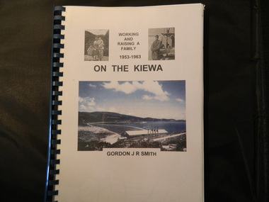
Book - On the Kiewa, Working & Raising a Family 1953 - 1963 by Gordon J. R. Smith, 9th September 2005
... Front Cover includes 2 small black and white photos either side of the title at the top and below the title a larger colored photo of Rocky Valley Dam. Author's name is underneath. ...Front Cover includes 2 small black and white photos either side of the title at the top and below the title a larger colored photo of Rocky Valley Dam. Author's name is underneath. Working & Raising a Family 1953 - 1963 by Gordon J. ...Personal account of Gordon Smith's life when living in Mt Beauty and Bogong townships while working for the SECV on the Kiewa Hydro Electric Scheme.Gordon gives an account of both working and living during the 1950s and early 1960s in a remote part of Victoria - the Kiewa Valley and in 2 small construction towns. He gives a lot of detail eg. the weather, his work, the people, the activities, his family and leisure time.Plastic threaded spine holding 282 pages with black and white photos. Front Cover includes 2 small black and white photos either side of the title at the top and below the title a larger colored photo of Rocky Valley Dam. Author's name is underneath. "Dick Puttyfoot" on cover page.kiewa hydro electric scheme, state electricity commission of victoria., gordon smith -
 Kiewa Valley Historical Society
Photograph - Folder of Photographs – Photocopied set of black and white photographs (pages 39 - 48) from the display folder put together by KVHS to document life on the Kiewa Valley Hydro-electric Scheme
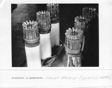
... Photograph of No 1 pipeline viewed from McKay Portal 9-Rocky Valley Dam Core Wall 10-Workmen working inside tunnel loading rocks into a rail truck. ...It is a circuit breaker Signed Ron White Ron was the Principal Hydro Engineer of the SEC Kiewa Scheme Page number 39 2-Big Hill Bench – Site of No. 5 Development (abandoned) Page number 40 3-No 1 Power Station Page number 41 4-No. 1 Pipeline, Anchor No. 8 Page number 42 5-Push Dozing – RD8 Tractor, 12 cubic yard Carryall and FD Cletrac Tractor Page number 43 6-No marking Page number 44 7-No marking Page number 45 8-Journal of State Electricity Commission of Victoria SEC Vol 15 No… April-May, 19… No 1 Pipeline-A view from McKay Portal G Hempenstall and D Sutton stiffening pipe section for transport during construction (….indicates missing text) Page Number 46 9-Rocky Valley Dam Core Wall Page number 47 10-No markings Page number 48 ...Photograph of No 1 pipeline viewed from McKay Portal 9-Rocky Valley Dam Core Wall 10-Workmen working inside tunnel loading rocks into a rail truck. ...Although the Kiewa Hydro-Electric Scheme was first proposed in 1911, construction did not commence until 1938. As part of the push to cut electricity costs and diversify supply, the Victorian Government (circa 1930) initiated the conversion from primarily brown coal supply to hydro – electricity. Field investigations during the 1940’s resulted in a new proposal for a scheme that had more than double the capacity of the 1938 scheme. The Kiewa Hydroelectric Scheme became the largest scheme of its kind in the State Of Victoria and the second largest scheme in Australia. The number of personnel involved in the planning and construction of the scheme increased dramatically. During the late 1940’s, most activity centered around the construction of the West Kiewa Power Station, Rocky Valley Reservoir, McKay Creek Power Station and the Bogong Creek Aqueduct.A common thread across all the larger hydro scheme constructions was the need for workers, both qualified and unqualified who came from around the world seeking a new life for themselves and their families. New accommodation and facilities were required for the army of workers engaged in construction in often remote and wild areas. The SEC had a high demand for timber, and set up the first of a number of sawmills at Bogong Creek in 1939 and set up the first hardwood logging in the headwaters of the Kiewa River. These new ‘towns’ such as Mt Beauty and Bogong, survived, serving the needs of operational personnel and their families, and expanding with growth of new industries. Mount Beauty, and to a lesser extent Bogong, are among these places. Large A3 size spiral bound display folder containing photocopied black and white photographs of various aspects of the early days of the Kiewa Valley Hydro-electric scheme including equipment, various work sites and photographs of workers and their families. 1-Breakdown in Circuit Breaker (Isolating Contacts) 2-Big Hill Bench- Site of No 5 Devlopment 3-No 1 Power Station 4-No 1 Pipeline, Anchor No 8 5-Push Dozing-RD8 Tractor 6- Tractor and driver at work 7- Workmen in unnamed tunnel 8- Front page of Journal of SECV Vol 15. Photograph of No 1 pipeline viewed from McKay Portal 9-Rocky Valley Dam Core Wall 10-Workmen working inside tunnel loading rocks into a rail truck. 1-Breakdown in (generator) Circuit Breaker (Isolating Contacts) Handwritten underneath (This is not a picture of any part of a generator. It is a circuit breaker Signed Ron White Ron was the Principal Hydro Engineer of the SEC Kiewa Scheme Page number 39 2-Big Hill Bench – Site of No. 5 Development (abandoned) Page number 40 3-No 1 Power Station Page number 41 4-No. 1 Pipeline, Anchor No. 8 Page number 42 5-Push Dozing – RD8 Tractor, 12 cubic yard Carryall and FD Cletrac Tractor Page number 43 6-No marking Page number 44 7-No marking Page number 45 8-Journal of State Electricity Commission of Victoria SEC Vol 15 No… April-May, 19… No 1 Pipeline-A view from McKay Portal G Hempenstall and D Sutton stiffening pipe section for transport during construction (….indicates missing text) Page Number 46 9-Rocky Valley Dam Core Wall Page number 47 10-No markings Page number 48 secv; kiewa hydro electric scheme; construction area; power stations; reservoirs; aqueduct; mt beauty; bogong -
 Kiewa Valley Historical Society
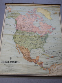
Maps - Educational x 10 and Kiewa Scheme x1
... The Kiewa Hydro Electric Works map is pinkish and shows Rocky Valley Dam, Lake Guy and Mt Beauty pondage in dark blue....The Kiewa Hydro Electric Works map is pinkish and shows Rocky Valley Dam, Lake Guy and Mt Beauty pondage in dark blue. ...Maps were used to teach children geography, the explorers, the minerals, the world etc. The school bought and stored the maps so that they were available for use. This predated electronic devices. The KHE Works map was hand drawn showing lots of detail.These maps were used by the Bogong Primary School. The Kiewa Hydro Electric Works was built by the SECV and produced hydro power. This map may have been used by pupils as well as workers on the Works. Large coloured maps on canvas, with a wooden beam along the top and bottom. Each one has a cord attached to the top so that the map may be hung up on a wall. Some are made by Chas. H. Scally & Co., Baronia Ave., Wollstonecraft, N.S.W. The Kiewa Hydro Electric Works map is pinkish and shows Rocky Valley Dam, Lake Guy and Mt Beauty pondage in dark blue.maps, educational maps, geography, primary school, kiewa hydro electric works -
 Kiewa Valley Historical Society
Set of 6 framed photographs - Kiewa Hydro Electric Scheme
... Dam Excavation - 5th April 1941 2. Bogong Residential Area Development - 24th April 1940 3. Beginning of Mt Beauty Township - 20th February 1947 4.Pretty Valley Bridge - 9th September 1940 5. Junction Dam - General View from Downstream - 15th September 1943 6. Construction of Dam Wall for Rocky...Valley KHES SECV 1. Junction Dam Excavation - 5th April 1941 2. Bogong Residential Area Development - 24th April 1940 3. Beginning of Mt Beauty Township - 20th February 1947 4.Pretty Valley Bridge - 9th September 1940 5. Junction Dam - General View from Downstream - 15th September 1943 6. Construction of Dam Wall for Rocky ...Official photos - Kiewa Hydro Electric Scheme constructed by State Electricity Commission of VictoriaOfficial photos of KHES in the Kiewa Valley1. Junction Dam Excavation - 5th April 1941 2. Bogong Residential Area Development - 24th April 1940 3. Beginning of Mt Beauty Township - 20th February 1947 4.Pretty Valley Bridge - 9th September 1940 5. Junction Dam - General View from Downstream - 15th September 1943 6. Construction of Dam Wall for Rocky Valley Dam - 1958khes, secv -
 Kiewa Valley Historical Society
Manila Folder - Newspaper cuttings and photos - Ryder Family, Ada & Walter Ryder Family
... Three slides a) Dairy Farm on banks of Kiewa River b) Mt Beauty c) Rocky Valley Dam 4. Four photos a) Beatrice Ryder on Empire Day b) Ada with son Walter Ryder c) Beatrice & Vera Ryder d)Skiers on High Plains...Three slides a) Dairy Farm on banks of Kiewa River b) Mt Beauty c) Rocky Valley Dam 4. Four photos a) Beatrice Ryder on Empire Day b) Ada with son Walter Ryder c) Beatrice & Vera Ryder d)Skiers on High Plains Ada & Walter Ryder Family Manila Folder - Newspaper cuttings and photos - Ryder Family ...The Ryder family have lived and farmed in the Kiewa Valley since the 1840sMemorabilia of the Ryder family in the Kiewa Valley is an example of changing activities and interests etc in the Kiewa Valley since the 1840s through to the current day.1. Merit Certificate for Dorothy Ryder 1938 2. Three newspaper cuttings a) Hospital Town Highlight b) Time Moves On c) Joan Lang - the woman who could...and did! 3. Three slides a) Dairy Farm on banks of Kiewa River b) Mt Beauty c) Rocky Valley Dam 4. Four photos a) Beatrice Ryder on Empire Day b) Ada with son Walter Ryder c) Beatrice & Vera Ryder d)Skiers on High Plainsb) and c) photos labelled on the backryder family, kiewa valley farming -
 Kiewa Valley Historical Society
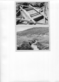
Photos - x6 Raceline repairs on the High Plains
... As part of the Kiewa Hydro Scheme the race lines were created to catch the water and direct it into the Rocky Valley Storage Dam....Kiewa Valley Historical Society Mount Beauty Information Centre 31 Bogong High Plains Rd Mt Beauty high-country As part of the Kiewa Hydro Scheme the race lines were created to catch the water and direct it into the Rocky Valley Storage Dam. Part of the Kiewa Hydro Electric Scheme on the Bogong High Plains. ...As part of the Kiewa Hydro Scheme the race lines were created to catch the water and direct it into the Rocky Valley Storage Dam.Part of the Kiewa Hydro Electric Scheme on the Bogong High Plains.6 black and white photos:- 2 with concrete framework, 2 concrete completed and 2 High Plaines race line.Alec McCullough Collectionkiewa hydro electric scheme, raceline, water power, bogong high plains -
 Kiewa Valley Historical Society
Photograph - Pretty Valley camp including workman's huts, Pretty Valley
... At the Pretty Valley Dam site erection of staff quarters was completed in April, 1947 and accommodation for workmen commenced in 1948 but suspended on 11th May for winter and resumed on 9th November. Construction of this camp was completed in 1949. A large dam was proposed at this site but was never constructed. Instead a small diversion dam was built which diverts water either to Rocky...Kiewa Valley Historical Society Mount Beauty Information Centre 31 Bogong High Plains Rd Mt Beauty high-country At the Pretty Valley Dam site erection of staff quarters was completed in April, 1947 and accommodation for workmen commenced in 1948 but suspended on 11th May for winter and resumed on 9th November. Construction of this camp was completed in 1949. A large dam was proposed at this site but was never constructed. Instead a small diversion dam was built which diverts water either to Rocky ...At the Pretty Valley Dam site erection of staff quarters was completed in April, 1947 and accommodation for workmen commenced in 1948 but suspended on 11th May for winter and resumed on 9th November. Construction of this camp was completed in 1949. A large dam was proposed at this site but was never constructed. Instead a small diversion dam was built which diverts water either to Rocky Valley Dam or to McKay Creek Power Station.An historical record of the type of accommodation provided for workmen during the construction of the Kiewa Hydro Scheme during the 1940's/50'sBlack and white photograph of Pretty Valley camp showing workman's huts and construction materials.Handwritten on back of photograph in blue pen - Pretty Valleypretty valley, workmen's huts, victorian alps, secv -
 Kiewa Valley Historical Society
Photograph of Pretty Valley Camp, Pretty Valley Camp, circa 1948
... At the Pretty Valley Dam site erection of staff quarters was completed in April, 1947 and accommodation for workmen commenced in 1948 but suspended on 11th May for winter and resumed on 9th November. Construction of this camp was completed in 1949. A large dam was proposed at this site but was never constructed. Instead a small diversion dam was built which diverts water either to Rocky...Kiewa Valley Historical Society Mount Beauty Information Centre 31 Bogong High Plains Rd Mt Beauty high-country At the Pretty Valley Dam site erection of staff quarters was completed in April, 1947 and accommodation for workmen commenced in 1948 but suspended on 11th May for winter and resumed on 9th November. Construction of this camp was completed in 1949. A large dam was proposed at this site but was never constructed. Instead a small diversion dam was built which diverts water either to Rocky ...At the Pretty Valley Dam site erection of staff quarters was completed in April, 1947 and accommodation for workmen commenced in 1948 but suspended on 11th May for winter and resumed on 9th November. Construction of this camp was completed in 1949. A large dam was proposed at this site but was never constructed. Instead a small diversion dam was built which diverts water either to Rocky Valley Dam or to McKay Creek Power Station.An historical record of the type of accommodation provided for workmen during the construction of the Kiewa Hydro Scheme during the 1940's/50'sBlack and white photograph of Pretty Valley Camp showing general terrain and the huts built to accommodate workmen employed on the Kiewa Hydro Electric Scheme.pretty valley, dam, water, workmen, camp -
 Kiewa Valley Historical Society
Photograph of Pretty Valley Workers Camp*, Pretty Valley Camp, circa 1949
... Erection of staff quarters at Pretty Valley was completed in April, 1947 and accommodation for construction workers commenced in 1948 but suspended on 11th May for winter and resumed on 9th November. Construction of this camp was completed in 1949. A large dam was proposed at this site but was never constructed. Instead a small diversion dam was built which diverts water either to Rocky...Kiewa Valley Historical Society Mount Beauty Information Centre 31 Bogong High Plains Rd Mt Beauty high-country Erection of staff quarters at Pretty Valley was completed in April, 1947 and accommodation for construction workers commenced in 1948 but suspended on 11th May for winter and resumed on 9th November. Construction of this camp was completed in 1949. A large dam was proposed at this site but was never constructed. Instead a small diversion dam was built which diverts water either to Rocky ...Erection of staff quarters at Pretty Valley was completed in April, 1947 and accommodation for construction workers commenced in 1948 but suspended on 11th May for winter and resumed on 9th November. Construction of this camp was completed in 1949. A large dam was proposed at this site but was never constructed. Instead a small diversion dam was built which diverts water either to Rocky Valley Dam or to McKay Creek Power Station.An historical record of the type of accommodation provided for workmen during the construction of the Kiewa Hydro Scheme during the 1940's/50's.A black and white photograph of Pretty Valley Camp, c 1949. Dead trees are in the foreground, on both the left and right side of the photograph and a small snow gum is evident. There are camp huts and a much larger building behind these, possibly a workshop, and power poles are evident bringing electricity to the site.Handwritten in blue ink on back of photograph "Pretty Valley Camp. 5600 ft. above sea level".pretty valley, dam, water, workmen, camp -
 Falls Creek Historical Society
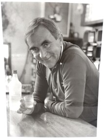
Photograph - Frank May at Falls Creek 1951
... In September 1950 he transferred to a similar position at the Rocky Valley Dam construction site. He worked from October to April at Rocky Valley but then moved to Bogong Village as the construction site was closed during the winter. ...In September 1950 he transferred to a similar position at the Rocky Valley Dam construction site. He worked from October to April at Rocky Valley but then moved to Bogong Village as the construction site was closed during the winter. ...Frank May gained employment with the SEC on 1st July 1950 and was initially placed at Mount Beauty as a clerk. In September 1950 he transferred to a similar position at the Rocky Valley Dam construction site. He worked from October to April at Rocky Valley but then moved to Bogong Village as the construction site was closed during the winter. In October 1951 he returned to Rocky Valley but in November 1951 government funding cutbacks forced the SEC to he and many others from the Kiewa Hydro-Electricity Scheme were transferred or retrenched. Frank was transferred to the SEC in Colac where he worked as a meter reader. During his time at Falls Creek, Frank was a member of the Bogong Ski Club and enjoyed many adventures skiing on the High Plains.These images are significant as they depict an early SEC working skiing at Falls Creek.Two black and white images of Frank Mayfrank may, sec falls creek, bogong ski club -
 Falls Creek Historical Society
Article - "Father" watches over his mountain-top family, 30 July 1986
... Ory then moved to work on the Snowy Mountain Scheme including driving a truck to fill the wall of the Rocky Valley dam. In 1952 Ory was recruited by the Albury Ski Club as its lodge supervisor. ...Ory then moved to work on the Snowy Mountain Scheme including driving a truck to fill the wall of the Rocky Valley dam. In 1952 Ory was recruited by the Albury Ski Club as its lodge supervisor. ...This article acknowledged the naming of Ory's Trail at Falls Creek in 1986. Orest “Ory” Frueauf was born in Kharkov, Russia in 1925 and moved to Germany with his family to escape persecution. He was conscripted to the German Army during the Second World War. He was a POW until 1948. He was recruited by a French construction company to work as and interpreter on a hydroelectricity project in Tasmania. Ory then moved to work on the Snowy Mountain Scheme including driving a truck to fill the wall of the Rocky Valley dam. In 1952 Ory was recruited by the Albury Ski Club as its lodge supervisor. That year he also entered into a business partnership with Cecil Dobson, running the general store “Whitehaven” and Post Office at Falls Creek. They extended their business by adding accommodation turning Whitehaven into one of the best commercial lodges at Falls Creek. Ory and Cecil dissolved their business partnership in 1963 and Ory went on to build a new lodge called “Snowhaven” at the site of the present day Frueauf Village, Falls Creek. Ory retired to Tawonga, Victoria in 1992 and passed away in 1999.This article is significant because it documents the naming of Ory's Trail to recognise a pioneer of Falls Creek.A newspaper item about Ory Freauf on the occasion of the naming of Ory's Trail at Falls Creek.falls creek pioneers, frueauf, ory frueauf -
 Falls Creek Historical Society
Photograph - Portrait Ory Frueauf
... Ory then moved to work on the Snowy Mountain Scheme including driving a truck to fill the wall of the Rocky Valley dam. In 1952 Ory was recruited by the Albury Ski Club as its lodge supervisor. ...Ory then moved to work on the Snowy Mountain Scheme including driving a truck to fill the wall of the Rocky Valley dam. In 1952 Ory was recruited by the Albury Ski Club as its lodge supervisor. ...This photograph was taken circa 1981 - 1982 by Tourism Victoria. Orest “Ory” Frueauf was born in Kharkov, Russia in 1925 and moved to Germany with his family to escape persecution. He was conscripted to the German Army during the Second World War. He was a POW until 1948. He was recruited by a French construction company to work as and interpreter on a hydroelectricity project in Tasmania. Ory then moved to work on the Snowy Mountain Scheme including driving a truck to fill the wall of the Rocky Valley dam. In 1952 Ory was recruited by the Albury Ski Club as its lodge supervisor. That year he also entered into a business partnership with Cecil Dobson, running the general store “Whitehaven” and Post Office at Falls Creek. They extended their business by adding accommodation turning Whitehaven into one of the best commercial lodges at Falls Creek. Ory and Cecil dissolved their business partnership in 1963 and Ory went on to build a new lodge called “Snowhaven” at the site of the present day Frueauf Village, Falls Creek. The trail known as Ory's Trail is also named in his honour. Ory retired to Tawonga, Victoria in 1992 and passed away in 1999.This image is significant because it portrays a pioneer of Falls Creek.A4 size black and white photograph of Ory Frueauf standing at the bar at Snowhaven Lodge with Vovka-Finlandia VodkaOn back of photograph: Orest Freauf 1925-1997. 1925 - Born in Kharkov, Russia, 1951 Tasmania Hydro Electric Co; 1954 Howman's Gap, Kiewa Hydroelectric Scheme; 1955 Falls Creek Trading and Transport Co; 1957 Winterhaven Ski Lodge; 1963 Snowhaven Ski Lodge; 1992 Tawonga Southory freauf, hydro electric, tourism victoria, winterhaven ski lodge, snowhaven ski lodge, snow, orest frueauf -
 Falls Creek Historical Society
Magazine - Fall-Line - Australia's National Skiing Magazine July - Aug 1979
... This issue included an extensive article discussing the possible of the development of Lakeside Resort on the shores of Rocky Valley Dam as well as an update on recent changes at Falls Creek. ...This issue included an extensive article discussing the possible of the development of Lakeside Resort on the shores of Rocky Valley Dam as well as an update on recent changes at Falls Creek. ...“Fall-Line” was one of a series of magazines published by the Victorian Ski Association. It was produced from 1979 until 1985. It superseded their previous publication, “Ski” magazine and was followed by the “Australian Skiing” magazine. The Victorian Ski Association was formed in 1955.This magazine is significant because it documents developments in the ski industry in Australia.A magazine featuring a coloured image on the cover and containing articles and advertising related to developments in skiing in Australia. This issue included an extensive article discussing the possible of the development of Lakeside Resort on the shores of Rocky Valley Dam as well as an update on recent changes at Falls Creek. FALLS CREEK The ski patrol has been increased from seven to eight, under the leadership of Senior Patroller John McDonald, and two new radios have been purchased. A four wheel drive ambulance has been purchased to replace the old conventional drive model. It will provide free ambulance transport between Falls Creek and Mt. Beauty, and will be driven by trained volunteer personnel. A new 165 vehicle day visitor car park has been completed at Windy Corner, adjacent to the approved toboggan slope. The closest car park to Falls Creek's Nordic Preferred Area, its capacity will be doubled next summer. A planning permit has been issued to Treglor Pty. Ltd. for its proposed hotel/convention centre. Construction is expected to begin after the season. A new Mercedes 800 tractor with Schmidt Snowcutter recently arrived on the mountain and will be used to clear the car parking areas Falls Creek continues to be among Australia's most expensive resorts, with a high season day ticket price of $13.50. Falls Creek's newest commercial lodge, Lakeside Lodge, has opened with accommodation for more than 50 people and luxury facilities including private rooms with full ensuite, sauna, spa pool, and a dining room for guests. It is located at the top of Schuss St. just behind Imaj flats and very close to the village bowl.australian ski magazines, skiing australia, victorian ski association -
 Kiewa Valley Historical Society
11 Black and White photographs of the Rocky Valley area, c1948
... Rocky Valley. Also in 1947 construction of a stream diversion was commenced to allow excavation to commence for the dam wall. ...Rocky Valley Camp. October 1948". Also stamped on the back "998L" Photo No. 3 -on the back, printed in ink "Rocky Valley Hostel October 1948". Also stamped on the back '998L' Photo No. 4 - on the back, printed in ink "Spion Kopje from bedroom window. October 1948". Stamped on the back '998L'. Photo No. 5 - on the back, printed in ink "Rocky Valley Basin Dec. 1948." In pencil on back, 14. Photo No. 6 - on the back, printed in ink "Site of Wall for Rocky Valley Dam...These photographs show the type of terrain in the area prior to the construction and filling of Rocky Valley Dam. Also of interest is the type of accommodation provided for those working on the construction and the early cranes available in the 1940/50's. ...In October 1947 construction was commenced on the erection of the workmen's camp at Rocky Valley. Also in 1947 construction of a stream diversion was commenced to allow excavation to commence for the dam wall. In the summer of 1948/49, stripping of the foundation area on both sides of the river was carried out. Weather conditions were not always favourable during the construction, particularly 1955/56 summer, and work would have to cease each year for the winter season due to the severe conditions. The dam is a earth and rock fill structure with a height of about 30.5 metres and crest length 518.16 metres and was completed in March, 1959.These photographs show the type of terrain in the area prior to the construction and filling of Rocky Valley Dam. Also of interest is the type of accommodation provided for those working on the construction and the early cranes available in the 1940/50's. Of historical importance to understand the conditions in the early construction of the Kiewa Hydro Electric SchemeEleven small black and white photographsPhoto No. 1 - on the back, printed in ink"Rocky Valley - New Mess & offices Dec. 1948". In pencil '14 on the back Photo No. 2 - on the back, printed in ink "Rocky Valley Camp. October 1948". Also stamped on the back "998L" Photo No. 3 -on the back, printed in ink "Rocky Valley Hostel October 1948". Also stamped on the back '998L' Photo No. 4 - on the back, printed in ink "Spion Kopje from bedroom window. October 1948". Stamped on the back '998L'. Photo No. 5 - on the back, printed in ink "Rocky Valley Basin Dec. 1948." In pencil on back, 14. Photo No. 6 - on the back, printed in ink "Site of Wall for Rocky Valley Dam Dec. 1948". In pencil on back, 14. Photo No. 7 - On the back, printed in ink "Commencing of Diversion Tunnel Rocky Valley December 1948". In pencil on back, 14. Photo No. 8 - on the back, printed in ink "One of the two electric cranes at Rocky Valley December 1948". In pencil on back, 14. Photo No. 9 - on the back, printed in ink "'Rapier' (H.Y.) electric crane Rocky Valley December 1948". In pencil on back, 14 . Photo No. 10 - on the back, printed in ink " Pretty Valley Pump line construction Mt. Cope in Background Nov 1948. Circular stamp with the words 'print by Wilson White Albury' in the circle. Photo No. 11 - on the back, printed in ink "Stringing cable on Ruined Castle October 1948. Same stamp as No. 10. In pencil '31'. rocky valley; pretty valley; ruined castle; bogong high plains; kiewa hydro electric scheme -
 Kiewa Valley Historical Society
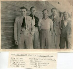
Set of 4 photographs of SECV Clerical staff, 1940 - 1941
... From 1937 to 1944 the construction of dams at Pretty Valley, Rocky Valley and the Junction Dam were undertaken requiring large numbers of planning and support staff to see the projects successfully completed. ...From 1937 to 1944 the construction of dams at Pretty Valley, Rocky Valley and the Junction Dam were undertaken requiring large numbers of planning and support staff to see the projects successfully completed. ...The Kiewa Hydroelectric Scheme is the largest hydro-electric scheme in Victoria and the second largest in mainland Australia after the Snowy Mountains Scheme. The scheme is situated in the Australian Alps in north-eastern Victoria about 350 km from Melbourne and is wholly owned by AGL Energy. The scheme was originally constructed between 1938 and 1961 by the State Electricity Commission of Victoria although it was privatised in the 1990s. The scheme was originally developed solely for electricity generation, unlike the Snowy Mountains Scheme, which was also intended to direct water west of the Snowy Mountains for purposes of irrigation. From 1937 to 1944 the construction of dams at Pretty Valley, Rocky Valley and the Junction Dam were undertaken requiring large numbers of planning and support staff to see the projects successfully completed. Planning and support staff were the backbone of the successful completion of the Kiewa Valley Hydro Electric Scheme and contributed significantly to the development of the Kiewa Valley area. Many descendants of the men in the photographs still living and working in the local areaSet of 4 black and white photographs of SECV clerical staff – Circa 1940/1941Typed on note glued to back of each photo, Numbers handwritten in blue ink in top left hand corner 1. DRAWING OFFICE STAFF KIEWA C. 1940-41 Bob Morgan – Construction Draftsman; Duncan Kerr – Draftsman; Rob Hollands – Survey Draftsman; Arthur Keeble – Office Engineer; Bill Godfrey – Draftsman 2. CLERICAL OFFICE STAFF KIEWA Peter Harnetty – Clerical; Bert Connors – Clerical; John Martin – Stores Clerical; Ken Calder – Head Storekeeper; Bill black – Construction Records 3. CLERICAL OFFICE STAFF KIEWA Jack Norman, Herb Kendall, Jack Bray – Stores Clerical; Ken Calder – Head Storekeeper; Jim Swain, George Milner – Stores Clerical; Jim Gleeson – Storekeeper; John Martin – Stores Clerical 4. OFFICE STAFF KIEWA C. 1940 Don Faulkner – Cadet Engineer; Tas Davies – Survey Draftsman; Bob Morgan – Construction Darftsman; R.J. Martin, Arthur Keeble – Office Engineers; Rob Hollands – Survey Draftsman; Jack Wollard – Head Surveyor; Harry Wilson – Plan Officer. Printing Plans Handwritten in red ink on back of photo 4 – Refer Rob Hollands secv clerical staff -
 Kiewa Valley Historical Society
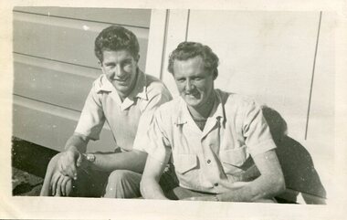
Photograph of Ray Esdaile and unidentified man, 1950
... From 1937 to 1944 the construction of dams at Pretty Valley, Rocky Valley and the Junction Dam were undertaken requiring large numbers of planning and support staff to see the projects successfully completed. ...From 1937 to 1944 the construction of dams at Pretty Valley, Rocky Valley and the Junction Dam were undertaken requiring large numbers of planning and support staff to see the projects successfully completed. ...The Kiewa Hydroelectric Scheme is the largest hydro-electric scheme in Victoria and the second largest in mainland Australia after the Snowy Mountains Scheme. The scheme is situated in the Australian Alps in north-eastern Victoria about 350 km from Melbourne and is wholly owned by AGL Energy. The scheme was originally constructed between 1938 and 1961 by the State Electricity Commission of Victoria although it was privatised in the 1990s. The scheme was originally developed solely for electricity generation, unlike the Snowy Mountains Scheme, which was also intended to direct water west of the Snowy Mountains for purposes of irrigation. From 1937 to 1944 the construction of dams at Pretty Valley, Rocky Valley and the Junction Dam were undertaken requiring large numbers of planning and support staff to see the projects successfully completed. Planning and support staff were the backbone of the successful completion of the Kiewa Valley Hydro Electric Scheme and contributed significantly to the development of the Kiewa Valley area. Many descendants of the original SECV workers are still living and working in the local areaBlack and white photograph of 2 men, one identified as Ray Esdaile at Mt Beauty SEC Camp in 1950Handwritten on back of photograph in blue ink: Ray Esdaile and self (unidentified) 1950 Mt Beauty Camp SECray esdaile, secv, mt beauty