Showing 322915 items matching "streets,roads,melbourne,map,melway"
-
 Eltham District Historical Society Inc
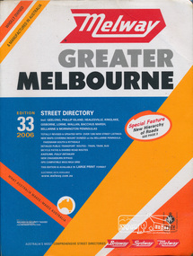
Book, Melway Publishing, Melway Greater Melbourne street directory : including Geelong, Phillip Island, Healesville, Kinglake, Gisborne, Lorne, Wallan, Bacchus Marsh Bellarine & Mornington Peninsulas; Edition 33, 2006, 2005
... Melway Greater Melbourne street directory : including Geelong, Phillip Island, Healesville, Kinglake, Gisborne, Lorne, Wallan, Bacchus Marsh Bellarine & Mornington Peninsulas; Edition 33, 2006...streets,roads,melbourne,map,melway...Edition 33. 2006 Coloured detailed maps accessed by a street or location index. ...Street directory with plastic cover, coloured maps, 902 pages...Melway Publishing...32 Ricketts Road, Mount Waverley, Victoria...Detailed public transport routes - train, tram, bus, bicycle paths & shared road routes. Eastlink fully detailed new Craigieburn bypass GPS compatible WGS/MGA Grid Special feature: New Hierachy of Roads streets,roads,melbourne,map,melway Street directory with plastic cover, coloured maps, 902 pages Melway Greater Melbourne street directory : including Geelong, Phillip Island, Healesville, Kinglake, Gisborne, Lorne, Wallan, Bacchus Marsh Bellarine & Mornington Peninsulas; Edition 33, 2006 Book Melway Publishing ...Edition 33. 2006 Coloured detailed maps accessed by a street or location index. Cover: Totally revised and updated with over 1380 new street listings new maps covering Mount Duneed on the Bellarine Peninsula, Pakenham South and Rythdale. Detailed public transport routes - train, tram, bus, bicycle paths & shared road routes. Eastlink fully detailed new Craigieburn bypass GPS compatible WGS/MGA Grid Special feature: New Hierachy of Roads Street directory with plastic cover, coloured maps, 902 pagesstreets,roads,melbourne,map,melway -
 Eltham District Historical Society Inc
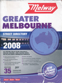
Book, Melway Greater Melbourne street directory 2008 : including Geelong, Phillip Island, Healesville, Kinglake, Gisborne, Lorne, Bacchus March, Wallan, Bellarine & Mornington Peninsulas; Edition 35, 2008, 2007
... Melway Greater Melbourne street directory 2008 : including Geelong, Phillip Island, Healesville, Kinglake, Gisborne, Lorne, Bacchus March, Wallan, Bellarine & Mornington Peninsulas; Edition 35, 2008...streets,roads,melbourne,map,melway...Edition 35. 2008 Coloured detailed maps accessed by a street or location index. ...Street directory, coloured maps, indexes, 1201 pages...Melway Publishing...32 Ricketts Road, Mount Waverley, Victoria...Eastlink fully detailed, Victoria Racing Club, Flemington enlargement, GPS compatible WGS/MGA Grid displayed, This editon is available in LARGE PRINT format, new eway electronic street directory now available - www.melway.com.au Special feature: New Hierachy of Roads streets,roads,melbourne,map,melway Street directory, coloured maps, indexes, 1201 pages Melway Greater Melbourne street directory 2008 : including Geelong, Phillip Island, Healesville, Kinglake, Gisborne, Lorne, Bacchus March, Wallan, Bellarine & Mornington Peninsulas; Edition 35, 2008 Book Melway Publishing ...Edition 35. 2008 Coloured detailed maps accessed by a street or location index. Cover: Totally revised and updated with over 730 additional street listings, new maps extending the Gisbourne and Wallan areas. The most comprehensive public transport routes information - train, tram, bus, walking and bicycle tracks. Eastlink fully detailed, Victoria Racing Club, Flemington enlargement, GPS compatible WGS/MGA Grid displayed, This editon is available in LARGE PRINT format, new eway electronic street directory now available - www.melway.com.au Special feature: New Hierachy of Roads Street directory, coloured maps, indexes, 1201 pagesstreets,roads,melbourne,map,melway -
 Sunshine and District Historical Society Incorporated
Book - Melway Greater Melbourne Street Directory 1996, Melway Publishing Pty Ltd, 1996
... Melway Greater Melbourne Street Directory 1996...Melway Greater Melbourne Street Directory Edition 24...Melway Publishing Pty Ltd...Sunshine and District Historical Society Incorporated The Hunt Club Community Arts Centre, 775 Ballarat Road, Deer Park 3023. Brimbank Library, 301 Hampshire Road, Sunshine 3020. melbourne The series of Melway Directories provides the most comprehensive maps of Great Melbourne area. ...The series of Melway Directories provides the most comprehensive maps of Great Melbourne area. Published in May 1996, this edition has been fully revised and may new features have been added. This Melway provides maps of the Greater Melbourne area extending to Bacchus Marsh, Geelong, Bellarine and Mornington Peninsulas, Healesville and Phillip Island. Past editions of the Melway can provide invaluable material for researchers and historians.Paper back booknon-fictionThe series of Melway Directories provides the most comprehensive maps of Great Melbourne area. Published in May 1996, this edition has been fully revised and may new features have been added. This Melway provides maps of the Greater Melbourne area extending to Bacchus Marsh, Geelong, Bellarine and Mornington Peninsulas, Healesville and Phillip Island. Past editions of the Melway can provide invaluable material for researchers and historians. -
 Sunshine and District Historical Society Incorporated
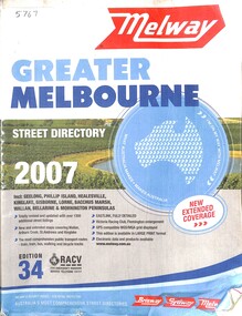
Book - Melway Greater Melbourne Street Directory 2007, Melway Publishing Pty Ltd, 2007
... Melway Greater Melbourne Street Directory 2007...Melway Greater Melbourne Street Directory 2007 Edition 34...Melway Publishing Pty Ltd...Sunshine and District Historical Society Incorporated The Hunt Club Community Arts Centre, 775 Ballarat Road, Deer Park 3023. Brimbank Library, 301 Hampshire Road, Sunshine 3020. melbourne The series of Melway Directories provides the most comprehensive maps of Great Melbourne area. ...The series of Melway Directories provides the most comprehensive maps of Great Melbourne area. In this Melway the coverage extends from Wallan, Whittlesea and Kinglake in the North to Mornington Peninsula in the South, Warburton and Tynong in the East to Bacchus Marsh and Geelong in the West. Regional areas of Gisborne, Torquay, Anglesea, Lorne and Phillip Island are also included. Past editions of the Melway can provide invaluable material for researchers and historians.Paper back book with plastic jacketnon-fictionThe series of Melway Directories provides the most comprehensive maps of Great Melbourne area. In this Melway the coverage extends from Wallan, Whittlesea and Kinglake in the North to Mornington Peninsula in the South, Warburton and Tynong in the East to Bacchus Marsh and Geelong in the West. Regional areas of Gisborne, Torquay, Anglesea, Lorne and Phillip Island are also included. Past editions of the Melway can provide invaluable material for researchers and historians. -
 Sunshine and District Historical Society Incorporated
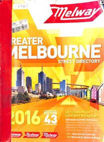
Book - Melway Greater Melbourne Street Directory 2016, Melway Publishing Pty Ltd, 2016
... Melway Greater Melbourne Street Directory 2016...Melway Greater Melbourne Street Directory 2016 Edition 43...Melway Publishing Pty Ltd...Sunshine and District Historical Society Incorporated The Hunt Club Community Arts Centre, 775 Ballarat Road, Deer Park 3023. Brimbank Library, 301 Hampshire Road, Sunshine 3020. melbourne The series of Melway Directories provides the most comprehensive maps of Great Melbourne area. ...The series of Melway Directories provides the most comprehensive maps of Great Melbourne area. In this Melway the coverage extends from Wallan, Whittlesea and Kinglake in the North to Mornington Peninsula in the South, Warburton and Tynong in the East to Bacchus Marsh and Geelong in the West. Regional areas of Kilmore, Macedon, Gisborne, Riddells Creek, Bannockburn, Torquay, Anglesea, Lorne, Phillip Island and Koo Wee Rup are also included. Past editions can provide invaluable material for researchers and historians.Paper back booknon-fictionThe series of Melway Directories provides the most comprehensive maps of Great Melbourne area. In this Melway the coverage extends from Wallan, Whittlesea and Kinglake in the North to Mornington Peninsula in the South, Warburton and Tynong in the East to Bacchus Marsh and Geelong in the West. Regional areas of Kilmore, Macedon, Gisborne, Riddells Creek, Bannockburn, Torquay, Anglesea, Lorne, Phillip Island and Koo Wee Rup are also included. Past editions can provide invaluable material for researchers and historians. -
 Sunshine and District Historical Society Incorporated
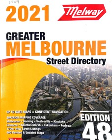
Book - Melway Greater Melbourne Street Directory 2021, Melway Publishing Pty Ltd, 2021
... Melway Greater Melbourne Street Directory 2021...Melway Greater Melbourne Street Directory 2021 Edition 48...Melway Publishing Pty Ltd...Sunshine and District Historical Society Incorporated The Hunt Club Community Arts Centre, 775 Ballarat Road, Deer Park 3023. Brimbank Library, 301 Hampshire Road, Sunshine 3020. melbourne The series of Melway Directories provides the most comprehensive maps of Great Melbourne area. ...The series of Melway Directories provides the most comprehensive maps of Great Melbourne area. In this Melway the coverage extends from Wallan, Whittlesea and Kinglake in the North to Mornington Peninsula in the South, Warburton and Tynong in the East to Bacchus Marsh and Geelong in the West. Regional areas of Kilmore, Macedon, Gisborne, Riddells Creek, Bannockburn, Torquay, Anglesea, Lorne, Phillip Island and Koo Wee Rup are also included. Past editions of the Melway can provide invaluable material for researchers and historians.Paper back booknon-fictionThe series of Melway Directories provides the most comprehensive maps of Great Melbourne area. In this Melway the coverage extends from Wallan, Whittlesea and Kinglake in the North to Mornington Peninsula in the South, Warburton and Tynong in the East to Bacchus Marsh and Geelong in the West. Regional areas of Kilmore, Macedon, Gisborne, Riddells Creek, Bannockburn, Torquay, Anglesea, Lorne, Phillip Island and Koo Wee Rup are also included. Past editions of the Melway can provide invaluable material for researchers and historians. -
 Victorian Aboriginal Corporation for Languages
Book, Melway Publishing, Melway Greater Melbourne street directory : including Geelong, Phillip Island, Healesville, Kinglake, Gisborne, Lorne, Wallan, Bacchus Marsh, Bellarine &? Mornington Peninsulas, 2005
... Melway Greater Melbourne street directory : including Geelong, Phillip Island, Healesville, Kinglake, Gisborne, Lorne, Wallan, Bacchus Marsh, Bellarine &? ...Street directory including the wider area surrounding Melbourne....maps...Melway Publishing...Victorian Aboriginal Corporation for Languages 33 Saxon Street Brunswick melbourne maps Victorian street maps street directories road maps maps Street directory including the wider area surrounding Melbourne. ...Street directory including the wider area surrounding Melbourne.mapsmaps, victorian street maps, street directories, road maps -
 Eltham District Historical Society Inc
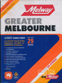
Book, Melway Publishing, Melway Greater Melbourne street directory : including Geelong, Phillip Island, Healesville, Bellarine & Mornington Peninsulas, 2002
... Melway Greater Melbourne street directory : including Geelong, Phillip Island, Healesville, Bellarine & Mornington Peninsulas.......melbourne...Coloured detailed maps accessed by a street or location index. ...1 atlas (24, 886 p.) : col. maps ; ...Melway Publishing...Cover: 20 additional pages of new maps, extended coverage of Bellarine Peninsula, further coverage of Werribee South, Public Transport Information, latest official suburb boundaries, CBD "hook turn" intersections map, over 1200 new streets, streets roads melbourne maps melway ISSN 03113957 1 atlas (24, 886 p.) : col. maps ; Melway Greater Melbourne street directory : including Geelong, Phillip Island, Healesville, Bellarine & Mornington Peninsulas. ...Edition 29. Coloured detailed maps accessed by a street or location index. Cover: 20 additional pages of new maps, extended coverage of Bellarine Peninsula, further coverage of Werribee South, Public Transport Information, latest official suburb boundaries, CBD "hook turn" intersections map, over 1200 new streets, 1 atlas (24, 886 p.) : col. maps ; ISSN 03113957streets, roads, melbourne, maps, melway -
 Eltham District Historical Society Inc
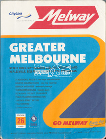
Book, Melway Greater Melbourne street directory : including Geelong, Phillip Island, Healesville, Bellarine & Mornington Peninsulas; Edition 26, 1999, 1999
... Melway Greater Melbourne street directory : including Geelong, Phillip Island, Healesville, Bellarine & Mornington Peninsulas; Edition 26, 1999......melbourne...Street directory with plastic cover, coloured maps, 772 pages 28 cm x 21.5 cm 1998...Melway Publishing...Melway Publishing...Eltham District Historical Society Inc 728 Main Rd Eltham melbourne streets roads melbourne maps melway Street directory with plastic cover, coloured maps, 772 pages 28 cm x 21.5 cm 1998 Melway Greater Melbourne street directory : including Geelong, Phillip Island, Healesville, Bellarine & Mornington Peninsulas; Edition 26, 1999 Book Melway Publishing Melway Publishing ...Street directory with plastic cover, coloured maps, 772 pages 28 cm x 21.5 cm 1998streets, roads, melbourne, maps, melway -
 Eltham District Historical Society Inc
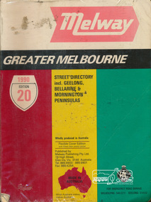
Book, Melway Publishing, Melway Greater Melbourne Street Directory, edition 20, 1990, 1990
... Melway Greater Melbourne Street Directory, edition 20, 1990......melway...Coloured detailed maps accessed by a street or location index....500 p. : col. maps ; Flexible cover edition with fitted clear plastic jacket....Melway Publishing...Eltham District Historical Society Inc 728 Main Rd Eltham melbourne Coloured detailed maps accessed by a street or location index. streets roads maps melway ISSN 03113957 500 p. : col. maps ; Flexible cover edition with fitted clear plastic jacket. ...Coloured detailed maps accessed by a street or location index.500 p. : col. maps ; Flexible cover edition with fitted clear plastic jacket.ISSN 03113957streets, roads, maps, melway -
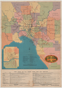
 Ringwood and District Historical Society
Map, Main Roads Map of Melbourne and Suburbs - c.1950
... Main Roads Map of Melbourne and Suburbs - c.1950...Map...Partially damaged double-sided multi-fold poster-size flyer with Melbourne map showing Collins Street Directory 1950 page references. ...Collins Directory Maps compass rose logo. Folding instructions - "Note: Don't hold here to fold. ...Main Roads Map of Melbourne and Suburbs - c.1950 Map ...Partially damaged double-sided multi-fold poster-size flyer with Melbourne map showing Collins Street Directory 1950 page references. Railway lines include Inner Circle Line sections (closed 1981) and Outer Circle Line sections (closed 1945). Insets include commercial advertising, information, and maps of Melbourne City Streets, Bayside Resorts, and Wharfs & Docks.Collins Directory Maps compass rose logo. Folding instructions - "Note: Don't hold here to fold. Hold right hand edge and push towards left, so that centre crease rises and sheet closes concertina fashion." Map reference headings include Racecourses, Hospitals, Cemeteries, Parks & Gardens, Colleges, and General. -
 Greensborough Historical Society
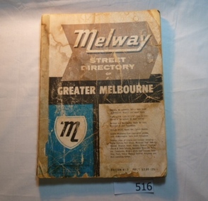
Book, Melway Street Directory of Greater Melbourne. Edition 1, 1966_
... Melway Street Directory of Greater Melbourne. ...melway...The first edition of this iconic Melbourne street directory published in 1966. ...Soft cover street directory. Coloured maps.189 pages....Soft cover street directory. Coloured maps.189 pages. Melway Street Directory of Greater Melbourne. ...The first edition of this iconic Melbourne street directory published in 1966. The directory is accompanied by an outline of the history of the concept and publication of Melway.A surviving first edition of the Melway is rare as these directories are designed to be updated each year. Of interest in this edition is maps of the Greensborough area before large scale subdivision of the land in the late 1960s and 1970s.Soft cover street directory. Coloured maps.189 pages.melway, street directories, melbourne. -
 Melbourne Tram Museum
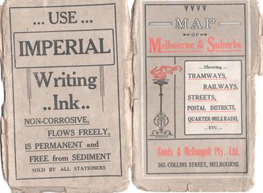
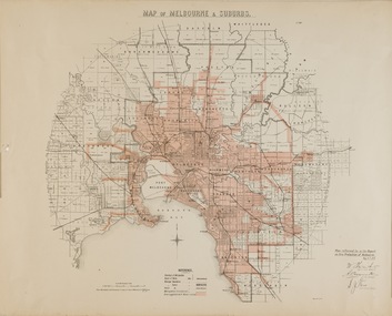
Map, Sands McDougall, Map of Melbourne and Suburbs showing Tramways, Railways, Streets, postal districts, Quarter-Mile Radii etc", c1919
... Map of Melbourne and Suburbs showing Tramways, Railways, Streets, postal districts, Quarter-Mile Radii etc"......melbourne...Map...One of a number of maps produced by Sands McDougall of Collins St. ... Produced by Sands and McDougall Pty Ltd of Collins St Melbourne. folded sheet of paper 6 sections wide x 6 sections or folds deep contained within a brown paper cover titled "Map of Melbourne and Suburbs showing Tramways, Railways, Streets, postal districts, Quarter-Mile Radii etc", showing both cable and electric tramways. ...Map of Melbourne and Suburbs showing Tramways, Railways, Streets, postal districts, Quarter-Mile Radii etc" Map Sands McDougall ...Shows railways, cable and electric tram lines c1919. One of a number of maps produced by Sands McDougall of Collins St. Includes the MTOCo zoo horse tram lines, the PMTT, HTT and MBCTT lines, but not the FNPTT or the FTT lines. See items 2885 and 6573 for other editions. Yields information about Melbourne c1919 and its public transport lines. Produced by Sands and McDougall Pty Ltd of Collins St Melbourne. folded sheet of paper 6 sections wide x 6 sections or folds deep contained within a brown paper cover titled "Map of Melbourne and Suburbs showing Tramways, Railways, Streets, postal districts, Quarter-Mile Radii etc", showing both cable and electric tramways. maps, melbourne, cable trams, tramways, railways, horse trams, nmetl, vr trams, sands mcdougall, mbctt, pmtt, htt, zoo horse tramway -
 Melbourne Tram Museum
Map, Sands McDougall, Map of Melbourne and Suburbs showing Tramways, Railways, Streets, postal districts, Quarter-Mile Radii etc", c1922
... Map of Melbourne and Suburbs showing Tramways, Railways, Streets, postal districts, Quarter-Mile Radii etc"......melbourne...Map...One of a number of maps produced by Sands McDougall of Collins St. ... Produced by Sands and McDougall Pty Ltd of Collins St Melbourne. Folded sheet of paper 6 sections wide x 6 sections or folds deep contained within a green paper cover titled "Map of Melbourne and Suburbs showing Tramways, Railways, Streets, postal districts, Quarter-Mile Radii etc", showing both cable and electric tramways. ...Map of Melbourne and Suburbs showing Tramways, Railways, Streets, postal districts, Quarter-Mile Radii etc" Map Sands McDougall ...Shows railways, cable and electric tram lines c1922. One of a number of maps produced by Sands McDougall of Collins St. Includes the Zoo horse tram lines. See acquisition and Research note by Duncan McAuslan. See items 2885, 6573, amd 6917 for other editions. On inside cover has current postal rates (including a war surcharge) and places worth visiting and on the rear cover, is an advertisement for Imperial ink.Yields information about Melbourne c1922 and its public transport lines. Produced by Sands and McDougall Pty Ltd of Collins St Melbourne. Folded sheet of paper 6 sections wide x 6 sections or folds deep contained within a green paper cover titled "Map of Melbourne and Suburbs showing Tramways, Railways, Streets, postal districts, Quarter-Mile Radii etc", showing both cable and electric tramways. maps, melbourne, cable trams, tramways, railways, horse trams, vr trams, sands mcdougall, zoo horse tramway, mmtb -
Southern Sherbrooke Historical Society Inc.
Map, "Melway Melbourne Town & Country Wall Map, Municipal Edition 1983", 1983
... Map..."Melway Melbourne Town & Country Wall Map, Municipal Edition 1983"...melbourne...Wall map showing municipal boundaries prior to 1995 amalgamations...."Melway Melbourne Town & Country Wall Map, Municipal Edition 1983" Map ...Wall map showing municipal boundaries prior to 1995 amalgamations.melbourne -
Melbourne Tram Museum
Map - Metlink folder - Travel Smart Maps, Travelsmart - Department of Infrastructure, "Melbourne's Public transport Map", 2005 to 2006
... "Melbourne's Public transport Map" ...Map...Maps published in association with Melway 1 - 5 x 8 fold map with card cover dated Jan 2005 with a price of $2. ...Metlink plastic folder containing maps.......Melway..."Melbourne's Public transport Map" Map Metlink folder - Travel Smart Maps Travelsmart - Department of Infrastructure Metlink Melway ...Set of four maps issued by Metlink - 2005 to 2006 contained within a Metlank badge plastic folder. Maps published in association with Melway 1 - 5 x 8 fold map with card cover dated Jan 2005 with a price of $2. Detailed map showing rail, tram and bus routes. 2 - 6 x 4 fold map for Moonee Valley - Travelsmart - for public transport, walking and cycling - dated 2005 3 - 7 x 4 fold map for Moreland - Travelsmart - for public transport, walking and cycling - dated October 2006 - includes notes on taxis. 4 - 7 x 4 fold map for Ride to Work day - 5 Oct. 2005Yields information about Melbourne Public Transport network.Metlink plastic folder containing maps.maps, metlink, public transport, moreland, moonee valley, travelsmart -
 Melbourne Tram Museum
Map, Sands and McDougall Pty Ltd, "Map of Melbourne and Suburbs showing Tramways, Railways, Streets, postal districts, Quarter-Mile Radii etc", c1930
... "Map of Melbourne and Suburbs showing Tramways, Railways, Streets, postal districts, Quarter-Mile Radii etc"...... Melbourne...Map...Produced by Sands and McDougall Pty Ltd of Collins St Melbourne. Map - folded sheet of paper 5 sections wide x 6 sections or folds deep contained within a dark grey paper cover titled "Map of Melbourne and Suburbs showing Tramways, Railways, Streets, postal districts, Quarter-Mile Radii etc", showing both cable and electric tramways. verted, but not Market St to Port Melbourne or South Melbourne. ...Melbourne Tram Museum 8 Wallen Road Hawthorn melbourne Trams tramways Maps Melbourne Cable Trams Tramways Railways Produced by Sands and McDougall Pty Ltd of Collins St Melbourne. ...Produced by Sands and McDougall Pty Ltd of Collins St Melbourne. Map - folded sheet of paper 5 sections wide x 6 sections or folds deep contained within a dark grey paper cover titled "Map of Melbourne and Suburbs showing Tramways, Railways, Streets, postal districts, Quarter-Mile Radii etc", showing both cable and electric tramways. verted, but not Market St to Port Melbourne or South Melbourne. Shows the Collins St line being constructed. Collins St routes were opened late 1929, map produced during the early 1930's prior to the closure of Market St - Port Melbourne. Has a detailed list of the postal districts.trams, tramways, maps, melbourne, cable trams, tramways, railways -
 Kew Historical Society Inc
Map, Department of Lands & Survey, Map of Melbourne & Suburbs, 1899
... Map of Melbourne & Suburbs...Map...This map was produced on 6 May 1899 by the Department of Lands & Survey Melbourne showing the distribution of water in Melbourne for use by fire brigades. ...Map accompanying report on fire protection of Melbourne showing those areas with water supplies tinted...."MAP OF MELBOURNE & SUBURBS / Plan referred to in the Report on Fire Protection in Melbourne, May 6th 1899 / Scale 80 Chains to 1 inch / Photo-lithographed at the Department of Lands and Survey Melbourne by T.F. ...Map of Melbourne & Suburbs Map Department of Lands & Survey ...The Metropolitan Fire Brigades Board commenced service on 1 May 1891. Melbourne and its surrounding suburbs were divided into 5 sub districts each with a district superintendent and paid firefighters with additional support from paid auxiliaries. This map was produced on 6 May 1899 by the Department of Lands & Survey Melbourne showing the distribution of water in Melbourne for use by fire brigades. While by 1910, there were 123,227 connections to Melbourne's water supply system, it is unclear in this 1899 map whether water was supplied to all built structures in the defined areas or only to fire hydrants and stand pipes.Map accompanying report on fire protection of Melbourne showing those areas with water supplies tinted."MAP OF MELBOURNE & SUBURBS / Plan referred to in the Report on Fire Protection in Melbourne, May 6th 1899 / Scale 80 Chains to 1 inch / Photo-lithographed at the Department of Lands and Survey Melbourne by T.F. McGauran, 1891" / May 1899 No.76"water reticulation -- melbourne (vic.), department of lands & survey -- historic maps, fire brigades -- melbourne (vic.), cartography -
Greensborough Historical Society
Map, Melway Publishing Pty Ltd, Greensborough: Melbourne on CD
... Map...Greensborough: Melbourne on CD......melway...Map...Copy of part of Greensborough street Map...Coloured street map of Greensborough...Melway Publishing Pty Ltd...Copy of part of Greensborough street Map Greensborough melway Coloured street map of Greensborough Greensborough: Melbourne on CD Map Map Melway Publishing Pty Ltd ...Copy of part of Greensborough street MapColoured street map of Greensboroughgreensborough, melway -
 Eltham District Historical Society Inc
Book, Melway Great Melbourne street directory including Geelong, Phillip Island Healesville, Bellarine & Mornington Peninsulas, 1998
... Melway Great Melbourne street directory including Geelong, Phillip Island Healesville, Bellarine & Mornington Peninsulas......melbourne...Coloured detailed maps accessed by a street or location index. ...1 atlas (22, 772 p.) : col. maps ; ...Cover: (Includes) New Southbank map including Crown Complex, enlargements of Footscray and Kensington, bike paths, walking tracks & horse trails, latest public transport information, South east Australia tours maps, Vic Roads new route numbers, map of Australia streets maps roads melbourne ISSN 03113957 1 atlas (22, 772 p.) : col. maps ; Melway Great Melbourne street directory including Geelong, Phillip Island Healesville, Bellarine & Mornington Peninsulas Book ...25th edition. Coloured detailed maps accessed by a street or location index. Cover: (Includes) New Southbank map including Crown Complex, enlargements of Footscray and Kensington, bike paths, walking tracks & horse trails, latest public transport information, South east Australia tours maps, Vic Roads new route numbers, map of Australia1 atlas (22, 772 p.) : col. maps ; ISSN 03113957streets, maps, roads, melbourne -
 Eltham District Historical Society Inc
Book, Roads Corporation, Vic Roads 2000: results of intial community consultation, outer Melbourne rural fringe, August 1989
... Vic Roads 2000: results of intial community consultation, outer Melbourne rural fringe...Roads...Roads Corporation...[Melbourne], Vic....Library spine label and other markings inside 100p. Vic Roads 2000: results of intial community consultation, outer Melbourne rural fringe Book Roads Corporation ...This report presents a summary of the issues and needs communicated by community and road user groups, local government, industry and government department representatives, at two of a series of VICROADS Regional Workshops convened by the Roads Corporation, as the Vic Roads 2000 Victoria's Rural Arterial Strategy is developed. Includes three parts: Outer Metropolitan Regional Workshop Report, Outer Dandenong Regional Workshop Report and background paper - Outer Melbourne rural fringe regional economy and road travel demand.100p.non-fictionThis report presents a summary of the issues and needs communicated by community and road user groups, local government, industry and government department representatives, at two of a series of VICROADS Regional Workshops convened by the Roads Corporation, as the Vic Roads 2000 Victoria's Rural Arterial Strategy is developed. Includes three parts: Outer Metropolitan Regional Workshop Report, Outer Dandenong Regional Workshop Report and background paper - Outer Melbourne rural fringe regional economy and road travel demand.roads, vicroads -
 Melbourne Tram Museum
Ephemera - Map - Timetable, Melbourne & Metropolitan Tramways Board (MMTB), "Map and timetable of Melbourne Tram and Bus Services", March 1952
... "Map and timetable of Melbourne Tram and Bus Services"...Melbourne...Map provided information about Melbourne's tramway network in 1952. ...Fold out map (10 sections - 2 high x 5 wide), coloured of Melbourne's Tram and Bus routes, route numbers, rail lines, municipalities boundaries and location of major places of interest. ...Melbourne & Metropolitan Tramways Board (MMTB)...Melbourne Tram Museum 8 Wallen Road Hawthorn melbourne Map provided information about Melbourne's tramway network in 1952. ...Map provided information about Melbourne's tramway network in 1952. At base of map - timetable of all night trams and bus services. On rear index to routes, 1st and last services, time of Sunday am services, Latrobe St. services and photo of Wattle Park. The conversion of Bourke St to electric trams marked up. Copy 1 - has been marked for hypothetical extensions in blue pencil mainly in the northern and western suburbs. In particular note the Ballarat Road and South Road markings. Copy 2 - has been marked up for newer route numbers, following the opening of the Bourke St services and additional route numbers on the Essendon Depot lines. Demonstrates the provision of information about Melbourne tram services.Fold out map (10 sections - 2 high x 5 wide), coloured of Melbourne's Tram and Bus routes, route numbers, rail lines, municipalities boundaries and location of major places of interest. melbourne, tram and bus services, mmtb, buses, trams, routes, timetables, all night services -
 Vision Australia
Map - Object, Map of Australia, Polynesia, Melanesia and Malaysia, 1939
... Map of Australia, Polynesia, Melanesia and Malaysia...Map...Tactile map of Australian states and territories, as well as various countries and islands in the South Pacific region, including Papua New Guinea, Indonesia and the Malay peninsula. ...1 paper map with tactile metal markers in red and brown frames...Queensland Braille Map & Model Club...Vision Australia 454 Glenferrie Road Kooyong melbourne Tactile map of Australian states and territories, as well as various countries and islands in the South Pacific region, including Papua New Guinea, Indonesia and the Malay peninsula. queensland braille map and model club R.F. ...Tactile map of Australian states and territories, as well as various countries and islands in the South Pacific region, including Papua New Guinea, Indonesia and the Malay peninsula. 1 paper map with tactile metal markers in red and brown framesqueensland braille map and model club, r.f. tunley -
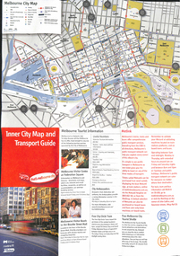 Melbourne Tram Museum
Map, City of Melbourne, "Inner City Transport Map", c1990
... "Inner City Transport Map"...... Map...Map...Melbourne City Tourist Shuttle, and two maps, one provided by Melway giving a list of attractions. ...City of Melbourne...Melbourne City Tourist Shuttle, and two maps, one provided by Melway giving a list of attractions. ...Map - 6 fold DL - full colour titled "Inner City Transport Map", providing information for Tourist Information centres, Metlink. Melbourne City Tourist Shuttle, and two maps, one provided by Melway giving a list of attractions. Published by City of Melbourne, Melway and Metlink with each of their logos.trams, tramways, map, public transport, city of melbourne, metlink -
 Mont De Lancey
Booklet, Department of Main Roads, Toll Roads and Bridges, 1981
... Toll Roads and Bridges......Roads...Early toll roads and bridge use in Australia from early settlement days to 1981....A small slim rectangular paperback brochure with a lithograph of the "New Toll Gate" on Parramatta Road, published in J.G. Austin's Sydney Views. ...Department of Main Roads...309 Castlereagh Street, Sydney, New South Wales, Australia...There are many photographs inside. Toll Roads and Bridges Booklet Department of Main Roads National Association of Australian State Road Authorities ...A brief history of tolls used throughout history, dating back around 1950 B.C. Early English and USA use is mentioned. Road and bridge tolls in Australia were collected for construction and maintenance of particular roads and bridges similar to their use in England. The clear photographs show the development in the this country up to 1981 when the brochure was published.A small slim rectangular paperback brochure with a lithograph of the "New Toll Gate" on Parramatta Road, published in J.G. Austin's Sydney Views. Green and white edging surrounds the picture with the title Toll Roads and Bridges printed in black lettering at the top right of the cover. On the back is a photograph of Toll cabins at the northern end of the Sydney Harbour Bridge showing automatic and manual toll booths with the symbol for NAASRA and National Association of Australian State Road Authorities printed in black and white at the bottom. Pp. 20. There are many photographs inside.non-fictionA brief history of tolls used throughout history, dating back around 1950 B.C. Early English and USA use is mentioned. Road and bridge tolls in Australia were collected for construction and maintenance of particular roads and bridges similar to their use in England. The clear photographs show the development in the this country up to 1981 when the brochure was published.road tolls, roads, bridges, history of tolls -
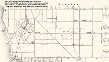 City of Moorabbin Historical Society (Operating the Box Cottage Museum)
Photograph - Map of Dendy's Special Survey, 1852 Map of Henry Dendy's Special Survey of 1841, 19th Century
... 1852 Map of Henry Dendy's Special Survey of 1841...Together, Dendy and Were decided on an area 5 miles south from Melbourne, bounded by North Road, East Boundary Road, South Road and to the west by Port Phillip Bay. ...Henry Dendy & Jonathan Were chose an area 5 miles south from Melbourne, bounded by North Road, East Boundary Road, South Road and to the west by Port Phillip Bay. ...Moorabbin County of Bourke / Photo-Lithographed at the department of Lands and Survey. /Melbourne. / Price 1/- ...Department of Lands and Survey, Melbourne....Henry Dendy & Jonathan Were chose an area 5 miles south from Melbourne, bounded by North Road, East Boundary Road, South Road and to the west by Port Phillip Bay. 1852 Map of Henry Dendy's Special Survey of 1841 Photograph Map of Dendy's Special Survey Department of Lands and Survey, Melbourne. ...A Map drawn in 1852 that shows the 5,120 acres that formed Dendy's Special Survey of 1841. In 1840 Henry Dendy, a farmer in Surrey, England acquired a "Special Survey" from the Commissioners for Land and Emigration which gave Dendy the right to choose land in Port Phillip for the "bargain basement" price of only £1 per acre for 5120 acres, (an area of 8 square miles). The Special Survey also included the right to "the shipment of a worker for every £20 spent on land, whose free passage was paid by the Crown, equalling a total of 100 workers ". Accordingly Dendy sold his English holdings and paid the required £5120 and arrived in Melbourne in February 1841. However by this time land in the new colony was selling for £5 - £40 per acre. Because Henry Dendy possessed the order from the Colonial Office in London he was able to successfully oppose Governor LaTrobe's attempts to alter the price of the land. Dendy appointed Jonathan Were, (an entrepreneur, who had arrived in 1839), as his Manager and who later became a partner. Together, Dendy and Were decided on an area 5 miles south from Melbourne, bounded by North Road, East Boundary Road, South Road and to the west by Port Phillip Bay. Were and Dendy pitched their tents in the area now known as ' Park St, Brighton' and sank a well near the corner of 'St Andrew's St and Wells St'. By 1845 J.B Were and Company had bought almost half of Dendy's land and Were built himself "Moorabbin House" in Were St Brighton made from stone, quarried from local cliffs. It was still standing in 1924. Legend records Moorabbin is named after the Aboriginal word for ' Mother's Milk ' The soil is very fertile and well supplied with water especially in the area called 'East Brighton' - now known as Bentleigh and East Bentleigh - By 1850 the area had developed with numerous market gardens, dairy farms, fruit gardens and vineyards supplying food for the growing population of Melbourne.This Map shows the birth of the Brighton and Moorabbin area. On 18th January1859 Brighton was proclaimed a Municipality and a Borough by October 1863. Meanwhile, following a Petition, the area of East and South Brighton, incorporating Mordialloc, Cheltenham, Mentone, Sandringham and Oakleigh separated from Brighton to form the Moorabbin District Roads Board becoming the first Local Government Authority. Col. William Mair was elected as the first Chairman of the Moorabbin Roads Board. Moorabbin Shire 1871 developed further and was declared a City in1934. The City of Moorabbin was the largest Municipality in Melbourne before the Amalgamation of Councils in 1994 when it was divided in the south to City of Kingston and in the north to City of Glen Eira A Photo-lithographed 1852 Map showing the 5,120 acres that formed Dendy's Special Survey of 1841. Henry Dendy & Jonathan Were chose an area 5 miles south from Melbourne, bounded by North Road, East Boundary Road, South Road and to the west by Port Phillip Bay. Moorabbin County of Bourke / Photo-Lithographed at the department of Lands and Survey. /Melbourne. / Price 1/- brighton, moorabbin, bentleigh, cheltenham, dendy henry, bent thomas, were jonathan, special survey -
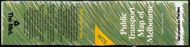
 Melbourne Tram Museum
Map, The Met, Public Transport Map of Melbourne - Get around on The Met, 8/1990
... Public Transport Map of Melbourne - Get around on The Met......Melbourne...Map...Melbourne transport map - dated August 1990 - includes a map of the ticket zones, and The Met contact details and notes where tickets can be obtained from...Fold out map (36 sections 9 across x 4 deep), "Public Transport Map of Melbourne", coloured of Melbourne's Tram and Bus routes, route numbers, rail lines, detailed for the central part of Melbourne and the outer Metropolitan services....Melbourne Tram Museum 8 Wallen Road Hawthorn melbourne Melbourne transport map - dated August 1990 - includes a map of the ticket zones, and The Met contact details and notes where tickets can be obtained from Yields information about Melbourne public transport services in August 1990 tramways Melbourne Tram services bus services Railways maps zones Fold out map (36 sections 9 across x 4 deep), "Public Transport Map of Melbourne", coloured of Melbourne's Tram and Bus routes, route numbers, rail lines, detailed for the central part of Melbourne and the outer Metropolitan services. ...Melbourne transport map - dated August 1990 - includes a map of the ticket zones, and The Met contact details and notes where tickets can be obtained fromYields information about Melbourne public transport services in August 1990Fold out map (36 sections 9 across x 4 deep), "Public Transport Map of Melbourne", coloured of Melbourne's Tram and Bus routes, route numbers, rail lines, detailed for the central part of Melbourne and the outer Metropolitan services.tramways, melbourne, tram services, bus services, railways, maps, zones -
 Ringwood and District Historical Society
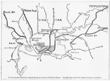
Document, Map of Melbourne suburbs showing proposed new railway lines - 1890
... Map of Melbourne suburbs showing proposed new railway lines - 1890...Black and white hand drawn map of Melbourne and some inner suburbs....Typed at bottom of map: "In this map the black lines indicate the proposed new suburban railways. ...Black and white hand drawn map of Melbourne and some inner suburbs. Map of Melbourne suburbs showing proposed new railway lines - 1890 Document ...Black and white hand drawn map of Melbourne and some inner suburbs.Typed at bottom of map: "In this map the black lines indicate the proposed new suburban railways. The light lines show the railways already in existence." -
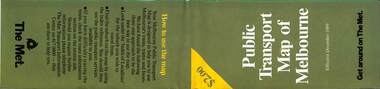
 Melbourne Tram Museum
Map, The Met, Public Transport Map of Melbourne - Get around on The Met, 8/1989
... Public Transport Map of Melbourne - Get around on The Met......Melbourne...Map...Melbourne transport map - dated August 1989 - zone ticket system, has a photo of the front of B2 2004, includes a map of the ticket zones, and The Met contact details....Fold out map (36 sections 9 across x 4 deep), "Public Transport Map of Melbourne", coloured of Melbourne's Tram and Bus routes, route numbers, rail lines, detailed for the central part of Melbourne and the outer Metropolitan services....Melbourne Tram Museum 8 Wallen Road Hawthorn melbourne Melbourne transport map - dated August 1989 - zone ticket system, has a photo of the front of B2 2004, includes a map of the ticket zones, and The Met contact details. ...Melbourne transport map - dated August 1989 - zone ticket system, has a photo of the front of B2 2004, includes a map of the ticket zones, and The Met contact details.Yields information about Melbourne public transport services in August 1989.Fold out map (36 sections 9 across x 4 deep), "Public Transport Map of Melbourne", coloured of Melbourne's Tram and Bus routes, route numbers, rail lines, detailed for the central part of Melbourne and the outer Metropolitan services.tramways, melbourne, tram services, bus services, railways, maps, zones -
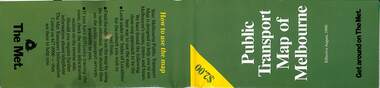
 Melbourne Tram Museum
Map, The Met, Public Transport Map of Melbourne - Get around on The Met, 12/1989
... Public Transport Map of Melbourne - Get around on The Met......Melbourne...Map...Melbourne transport map - dated December 1989 - scratch ticket system, has a photo of the front of B2 2004, includes a map of the ticket zones, and The Met contact details....Fold out map (36 sections 9 across x 4 deep), "Public Transport Map of Melbourne", coloured of Melbourne's Tram and Bus routes, route numbers, rail lines, detailed for the central part of Melbourne and the outer Metropolitan services....Melbourne Tram Museum 8 Wallen Road Hawthorn melbourne Melbourne transport map - dated December 1989 - scratch ticket system, has a photo of the front of B2 2004, includes a map of the ticket zones, and The Met contact details. ...Melbourne transport map - dated December 1989 - scratch ticket system, has a photo of the front of B2 2004, includes a map of the ticket zones, and The Met contact details.Yields information about Melbourne public transport services in December 1989 following the introduction of Scratch tickets.Fold out map (36 sections 9 across x 4 deep), "Public Transport Map of Melbourne", coloured of Melbourne's Tram and Bus routes, route numbers, rail lines, detailed for the central part of Melbourne and the outer Metropolitan services.tramways, melbourne, tram services, bus services, railways, maps, zones, scratch tickets