Showing 95 items matching "the peak country"
-
 Flagstaff Hill Maritime Museum and Village
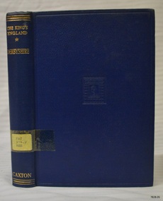
Book, The Kings England Derbyshire
... ...the peak country...The King's England - Derbyshire The Peak Country Edited by Arthur Mee Publisher: The Caxton Publishing Co ...The Warrnambool Mechanics' Institute’s publication collection is of both local and state significance. warrnambool shipwrecked-coast flagstaff-hill flagstaff-hill-maritime-museum maritime-museum shipwreck-coast flagstaff-hill-maritime-village shipwrecked-artefact book pattison collection warrnambool library warrnambool mechanics’ institute ralph eric pattison corangamite regional library service warrnambool city librarian mechanics’ institute library victorian library board warrnambool books and records warrnambool children’s library great ocean road the king's england - derbyshire the king's england derbyshire the peak country arthur mee Label on spine cover with typed text PAT 914.2 MEE Pastedown front endpaper has sticker from Warrnambool Public Library covered by a sticker from Corangamite Regional Library Service Front loose endpaper has a stamp from Corangamite Regional Library Service The King's England - Derbyshire The Peak Country Edited by Arthur Mee Publisher: The Caxton Publishing Co The Kings England Derbyshire Book ...This item is from the ‘Pattison Collection’, a collection of books and records that was originally owned by the Warrnambool Mechanics’ Institute, which was founded in Warrnambool in 1853. By 1886 the Warrnambool Mechanics’ Institute (WMI) had grown to have a Library, Museum and Fine Arts Gallery, with a collection of “… choice productions of art, and valuable specimens in almost every branch and many wonderful national curiosities are now to be seen there, including historic relics of the town and district.” It later included a School of Design. Although it was very well patronised, the lack of financial support led the WMI in 1911 to ask the City Council to take it over. In 1935 Ralph Pattison was appointed as City Librarian to establish and organise the Warrnambool Library as it was then called. When the WMI building was pulled down in 1963 a new civic building was erected on the site and the new Warrnambool Library, on behalf of the City Council, took over all the holdings of the WMI. At this time some of the items were separated and identified as the ‘Pattison Collection’, named after Ralph Pattison. Eventually the components of the WMI were distributed from the Warrnambool Library to various places, including the Art Gallery, Historical Society and Flagstaff Hill. Later some were even distributed to other regional branches of Corangamite Regional Library and passed to and fro. It is difficult now to trace just where all of the items have ended up. The books at Flagstaff Hill Maritime Village generally display stamps and markings from Pattison as well as a variety of other institutions including the Mechanics’ Institute itself. RALPH ERIC PATTISON Ralph Eric Pattison was born in Rockhampton, Queensland, in 1891. He married Maude Swan from Warrnambool in 1920 and they set up home in Warrnambool. In 1935 Pattison accepted a position as City Librarian for the Warrnambool City Council. His huge challenge was to make a functional library within two rooms of the Mechanics’ Institute. He tirelessly cleaned, cleared and sorted a disarrayed collection of old books, jars of preserved specimens and other items reserved for exhibition in the city’s museum. He developed and updated the library with a wide variety of books for all tastes, including reference books for students; a difficult task to fulfil during the years following the Depression. He converted all of the lower area of the building into a library, reference room and reading room for members and the public. The books were sorted and stored using a cataloguing and card index system that he had developed himself. He also prepared the upper floor of the building and established the Art Gallery and later the Museum, a place to exhibit the many old relics that had been stored for years for this purpose. One of the treasures he found was a beautiful ancient clock, which he repaired, restored and enjoyed using in his office during the years of his service there. Ralph Pattison was described as “a meticulous gentleman whose punctuality, floorless courtesy and distinctive neat dress were hallmarks of his character, and ‘his’ clock controlled his daily routine, and his opening and closing of the library’s large heavy doors to the minute.” Pattison took leave during 1942 to 1945 to serve in the Royal Australian Navy, Volunteer Reserve as Lieutenant. A few years later he converted one of the Museum’s rooms into a Children’s Library, stocking it with suitable books for the younger generation. This was an instant success. In the 1950’s he had the honour of being appointed to the Victorian Library Board and received more inspiration from the monthly conferences in Melbourne. He was sadly retired in 1959 after over 23 years of service, due to the fact that he had gone over the working age of council officers. However he continued to take a very keen interest in the continual development of the Library until his death in 1969. The Pattison Collection, along with other items at Flagstaff Hill Maritime Village, was originally part of the Warrnambool Mechanics' Institute’s collection. The Warrnambool Mechanics’ Institute Collection is primarily significant in its totality, rather than for the individual objects it contains. Its contents are highly representative of the development of Mechanics' Institute libraries across Australia, particularly Victoria. A diversity of publications and themes has been amassed, and these provide clues to our understanding of the nature of and changes in the reading habits of Victorians from the 1850s to the middle of the 20th century. The collection also highlights the Warrnambool community’s commitment to the Mechanics’ Institute, reading, literacy and learning in the regions, and proves that access to knowledge was not impeded by distance. These items help to provide a more complete picture of our community’s ideals and aspirations. The Warrnambool Mechanics Institute book collection has historical and social significance for its strong association with the Mechanics Institute movement and the important role it played in the intellectual, cultural and social development of people throughout the latter part of the nineteenth century and the early twentieth century. The collection of books is a rare example of an early lending library and its significance is enhanced by the survival of an original collection of many volumes. The Warrnambool Mechanics' Institute’s publication collection is of both local and state significance. The King's England - Derbyshire The Peak Country Edited by Arthur Mee Publisher: The Caxton Publishing Co Label on spine cover with typed text PAT 914.2 MEE Pastedown front endpaper has sticker from Warrnambool Public Library covered by a sticker from Corangamite Regional Library Service Front loose endpaper has a stamp from Corangamite Regional Library Servicewarrnambool, shipwrecked-coast, flagstaff-hill, flagstaff-hill-maritime-museum, maritime-museum, shipwreck-coast, flagstaff-hill-maritime-village, shipwrecked-artefact, book, pattison collection, warrnambool library, warrnambool mechanics’ institute, ralph eric pattison, corangamite regional library service, warrnambool city librarian, mechanics’ institute library, victorian library board, warrnambool books and records, warrnambool children’s library, great ocean road, the king's england - derbyshire, the king's england, derbyshire, the peak country, arthur mee -
 Warrnambool and District Historical Society Inc.
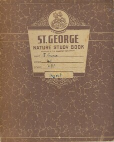
Work on paper - Booklets Fletcher Jones, 001143.1 Project Book 001143.2 Booklet:Plusites 001143.3 Flyer, Mid 20th century
... country as well as trading figures. It tells of the royal visit of 1954 and other social events and items of interest around the various shops. 001143.3 Flyer :The text on this flyer also tells the story of the development of the Fletcher Jones brand to the point where there in the year2000 retail expansion was still happening but the Warrnambool workforce had shrunk from over 1000 at the peak to approximately 200. ...country as well as trading figures. It tells of the royal visit of 1954 and other social events and items of interest around the various shops. 001143.3 Flyer :The text on this flyer also tells the story of the development of the Fletcher Jones brand to the point where there in the year2000 retail expansion was still happening but the Warrnambool workforce had shrunk from over 1000 at the peak to approximately 200. ...Fletcher Jones Clothing Factory was a key industry in Warrnambool from 1948 to its closure in 2005. The business was founded by David Fletcher Jones (1897-1977), a clothing manufacturer and retailer who worked as a hawker in the Western District following service with the A.I.F. in World War One. In 1924 Fletcher Jones opened three shops in Liebig Street selling men’s wear, hosiery and linen and operating a small tailoring business. He moved his shop to another location in Liebig Street and began to concentrate on men’s trousers production. In 1946 he opened a shop in Collins Street in Melbourne and eventually had stores and factories all over Australia. In Warrnambool he opened his factory at Pleasant Hill in Flaxman Street in 1948 and became a major Warrnambool employer, with over 1000 employees at one time. He transformed his business into a co-operative, with the name, ‘Fletcher Jones and Staff’ registered in 1947. The business diversified into other ranges of clothing for men and women but failed to compete with cheaper overseas clothing imports and the factory and shops were closed in the early 21st century. 001143.1 Project Book. This project book tells the story of the establishment and development of the Fletcher Jones company across the various stores which were established in Melbourne, Adelaide, Sydney, Geelong and Hobart. It explores the philosophy behind the business and milestones achieved and the factory gardens. The book itself provides an example of schoolwork completed in the mid 20th century. 001143.2 Booklet: Plusites: This is a staff booklet which has items of interest relating to staff such as births deaths and marriages. It tells of renovations and happenings in regard to the various shops around the country as well as trading figures. It tells of the royal visit of 1954 and other social events and items of interest around the various shops. 001143.3 Flyer :The text on this flyer also tells the story of the development of the Fletcher Jones brand to the point where there in the year2000 retail expansion was still happening but the Warrnambool workforce had shrunk from over 1000 at the peak to approximately 200. The company had commenced importing a range of clothing by this time These three items present different views of a company which was an important part of industry in Warrnambool for over 60 years in the latter part of the 20th century. The founder was one of Warrnambool’s most well respected people and many district people had connections to the firm. 001143.1 Project Book. Brown mottled card cover with cream insert for personal details. Back cover plain cream. It contains a student’s project work on the Fletcher Jones company. Some is handwritten and also contains a number of black and white photographs throughout the book. A coloured map of Australia is in the middle pages. 001143.2 Booklet: Plusites. White light card cover with dark blue text and diagram. Bottom left of page has a map of the coastline of Victoria. 20 pages. 001143.3 Flyer. Advertising Flyer re factory direct sales at Warrnambool. Black text with maroon border and Fletcher jones logo at the bottom and 4 photographs at the top. 001143.1 Project Book. T Cronin 4B WHS 001143.2 Booklet: Plusites. Vol 1 No 1 June 1954. 001143.3 Flyer fletcher jones, warrnambool history, fletcher jones and staff pty ltd -
 Warrnambool and District Historical Society Inc.
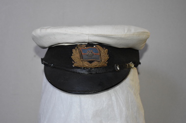
Hat, Navy Officer's, Mid 20th century
... country or rank. This hat is of minor interest as it is no longer in its original condition and has no known local provenance. Australian Navy Uniform History of Warrnambool Southhampton This is a Navy officer’s hat with a white cloth circular top and a black material base and a band lined with black material. It has a Bakelite peak ...This navy officer’s hat has been reconditioned and this alteration may have been done for theatrical purposes. No information is available on its original owner or his country or rank.This hat is of minor interest as it is no longer in its original condition and has no known local provenance. This is a Navy officer’s hat with a white cloth circular top and a black material base and a band lined with black material. It has a Bakelite peak. The black band has an off-centre cloth badge of metallic thread featuring decorative feathers and a flag with a blue and red six-pointed star. The hat appears to be a re-conditioning of an original hat and the badge is probably not an original one. The edges of the hat are frayed and soiled. The hat has a leather lining with the maker’s name inside the hat but this is illegibleSouthhamptonaustralian navy uniform, history of warrnambool -
 Warrnambool and District Historical Society Inc.
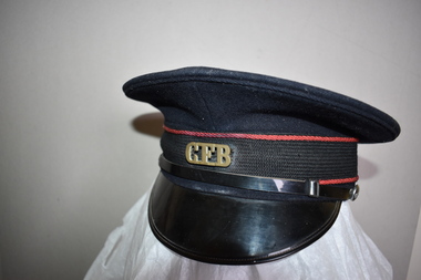
Country Fire Brigade Hat, Commonwealth Government Clothing Factory, Mid 20th century
... peak is made of green leather. Inside the hat is a plastic covering with a leather band. There is a cloth label with yellow printing. Country ...This hat was part of the uniform of the Country Fire Brigade. The organization now known as the Country Fire Authority was established in 1945 as a volunteer and community-based organization providing fire fighting and emergency services in regional and rural areas in Victoria. Today the organization includes career fire-fighters and funding is partly provided by a levy included in local Council rates. The owner of this hat is not known. This hat is of minor interest and is retained for display purposesThis is a hat with a circular flat crown made of black felt with 4 eyelets. Around the edge of the crown is a brown leather band with a fabric bow fastening and a black cloth ribbon with a red corded edging. In the centre is a brass badge with letters on it. The peak is made of patent leather with a black leather band on the upper edge with metal buttons. The inside of the peak is made of green leather. Inside the hat is a plastic covering with a leather band. There is a cloth label with yellow printing. Commonwealth Government Clothing Factory Melbourne 7 C.F.B. country fire fighting services warrnambool, history of warrnambool -
 Kiewa Valley Historical Society
Photograph - Mt Bogong - Tawonga, 06/05/1937
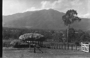
... Kiewa Valley Historical Society Mount Beauty Information Centre 31 Bogong High Plains Rd Mt Beauty high-country Mount Bogong located in the Alpine National Park and part of the Victorian Alps of the Great Dividing Range, is the highest mountain in Victoria, Australia, at 1,986 metres (6,516 ft) above sea level. The Big River separates the massif of the mountain from the Bogong High Plains to the south. From the nearby town of Mount Beauty to its summit, Mount Bogong rises more than 1,600 metres (5,200 ft), thus making it one of the highest peaks ...Mount Bogong located in the Alpine National Park and part of the Victorian Alps of the Great Dividing Range, is the highest mountain in Victoria, Australia, at 1,986 metres (6,516 ft) above sea level. The Big River separates the massif of the mountain from the Bogong High Plains to the south. From the nearby town of Mount Beauty to its summit, Mount Bogong rises more than 1,600 metres (5,200 ft), thus making it one of the highest peaks in Australia not only in terms of its elevation above sea level, but also in terms of actual base-to-summit prominence. Mount Bogong is a popular backcountry skiing mountain through winter but only has snow for the mid winter-spring months. It is around 30 kilometres (19 mi) by road and walking track or 12 kilometres (7.5 mi) direct to Mount Beauty. Falls Creek and Mount Hotham ski resorts are also nearby. Camping is relatively safe below the tree line but the summit ridgeline is very exposed. Emergency shelter is also available at Bivouac Hut on the Staircase Spur, and at Cleve Cole, above Camp Creek on the broad ridge to the south of the summit, and Michells Hut on the Eskdale Spur. Mt Bogong is a popular recreational venue in the Kiewa Valley for back country skiing and bush walking and is a favourite with sightseers and popular subject for photographersBlack and white photograph of Mt bogong taken from Tawonga - Thursday May 6th, 1937Handwritten on back of photograph. Thursday May 6th, 1937. Mt Bogong Tawongamt bogong, tawonga, kiewa valley -
 Kiewa Valley Historical Society
Photographs- Original S.E.C.V. home designs in Mt Beauty – Set of 6 black and white photographs
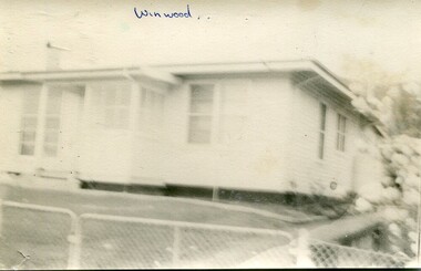
... Kiewa Valley Historical Society Mount Beauty Information Centre 31 Bogong High Plains Rd Mt Beauty high-country The townships of Mount Beauty and Bogong Village were constructed by the Victorian State Electricity Utility Commission (SEC) from the 1930’s to the 1950’s to house workers on the Kiewa Hydro Electric Scheme. At its peak ...The townships of Mount Beauty and Bogong Village were constructed by the Victorian State Electricity Utility Commission (SEC) from the 1930’s to the 1950’s to house workers on the Kiewa Hydro Electric Scheme. At its peak the Kiewa Scheme employed around 4000 people. Although the towns were built as temporary accommodation for the workers and their families, many stayed and even retired there after the scheme had finished. The Bright Council, now the Alpine Shire took over the control of the township in 1960 and today Mount Beauty is one of the most complete company towns in Victoria.The SECV provided several standard designs for the housing of workers and management in Mt Beauty. At the completion of the scheme the housing was retained and Mount Beauty now exists as one of the best examples of a company town in Victoria.There are many examples of the original houses remaining around the town. This is significant as the houses were only built as temporary accommodation and still remain functional after over 60 or more years of use.Set of 6 black and white photographs of original SECV temporary house designs in Mt Beauty.Written in blue ink on front of photos 1. Winwood 2. Winwood 3. K Type 4. K Type 5. English Precut 6. Cube mt beauty houses, secv housing -
 Kiewa Valley Historical Society
Folder - Mount Beauty Workmen's Club
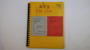
... country The Mount Beauty Workmen's Club was established in 1946. Formerly known as the Kiewa Hydro Workmen's Club. Social history of Mount Beauty during the construction of the Hydro Scheme and its aftermath. Workmen's Club Community Club West Peak ...The Mount Beauty Workmen's Club was established in 1946. Formerly known as the Kiewa Hydro Workmen's Club.Social history of Mount Beauty during the construction of the Hydro Scheme and its aftermath.Plastic spiral bound A4 folder with numerous plastic sleeves./ The folder contains club rules, some auditor's reports and financial statements and misc correspondence - mostly from 1990s./ Inside there are two rule booklets one red and one grey.On the top front cover of the red rules booklet is written 'Peart. A.L'.workmen's club, community club, west peak hotel, mt beauty, secv, kiewa hydro electric scheme -
 Kiewa Valley Historical Society
Map - Bogong High Plains & Adjacent Peaks x2, 1976
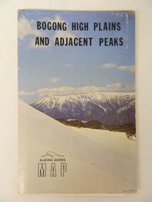
... Kiewa Valley Historical Society Mount Beauty Information Centre 31 Bogong High Plains Rd Mt Beauty high-country This map was produced as a result of the 'pressure from walkers' who are interested in climbing the accessible peaks on the Bogong High Plains. ...This map was produced as a result of the 'pressure from walkers' who are interested in climbing the accessible peaks on the Bogong High Plains. Places, huts and rivers are named and indexed. Contours are not given. Heights of mountains are in metres.The Bogong High Plains is a popular walking area and a National Park. This map identifies the mountains and peaks in the area at the time of publication. Some of the huts have since been destroyed by fire and Mt Niggerhead has since been renamed to Jaithmathang.Blue and white cardboard folded in half containing a folded black and white map of Bogong High Plains and Adjacent Peaks with index.bogong high plains. mountains. bushwalkers. walking. map. national park. recreation. cycling. tourism -
 Kiewa Valley Historical Society
Hat - Bowling x2
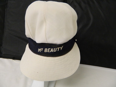
... country Lawn bowls required members to wear a white uniform which included a hat. Lawn bowls was played at Mt Beauty. Lawn bowls was played at Mt Beauty. lawn bowls. mt beauty. hat. clothing. bowling club, bowls "Mt Beauty" Label: Makers and size. White material hat with stiff peak ...Lawn bowls required members to wear a white uniform which included a hat. Lawn bowls was played at Mt Beauty.Lawn bowls was played at Mt Beauty.White material hat with stiff peak sown onto green material which is underneath the peak. The top of the hat is made of 8 triangular sections meeting in the centre. There is a black band between the peak and top of the hat. The band has "Mt Beauty" sewn on at the front. The other hat has green material all the way around as it has a peak at the front and back."Mt Beauty" Label: Makers and size.lawn bowls. mt beauty. hat. clothing., bowling club, bowls -
 Kiewa Valley Historical Society
Photo - Early photo of Bogong Township x2
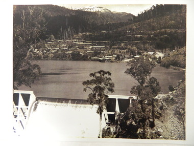
... country Bogong Village was built for the workers of the State Elecricity Commission of Victoria who were employed to construct the Kiewa Hydro electric Scheme. This photo shows their homes and offices etc., Lake Guy and the spillway during construction days. Bogong village was built as part of the Kiewa Hydro Electric Scheme. This photo gives a view of the village when it was at its peak ...Bogong Village was built for the workers of the State Elecricity Commission of Victoria who were employed to construct the Kiewa Hydro electric Scheme. This photo shows their homes and offices etc., Lake Guy and the spillway during construction days.Bogong village was built as part of the Kiewa Hydro Electric Scheme. This photo gives a view of the village when it was at its peak. Large photo of Mt Bogong Township with snow on the mountain in the background and the spillway over-flowing in the foreground. Some small trees amongst those burnt by the 1939 bushfire. (2 photos - one an enlarged copy)bogong village. kiewa hydro electric scheme. s.e.c.v.. lake guy. -
 Kiewa Valley Historical Society
Map - Railway Map of Victoria, Amended to 1/11/1945
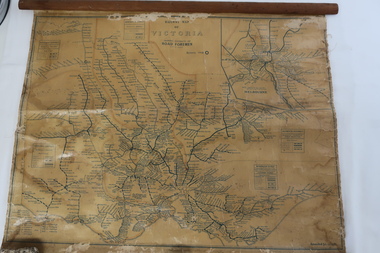
... Kiewa Valley Historical Society Mount Beauty Information Centre 31 Bogong High Plains Rd Mt Beauty high-country Railways began in the 1850s and were privately owned and operated. Later they were taken over by the Victorian Government reaching a peak in the early 1940s.Steam trains were followed by electric trains with both running after the war in 1945. ...Railways began in the 1850s and were privately owned and operated. Later they were taken over by the Victorian Government reaching a peak in the early 1940s.Steam trains were followed by electric trains with both running after the war in 1945.Bright was the closest station to the Kiewa Valley but road transport was used more often as the Kiewa Valley Highway was improved with the construction of the Kiewa Hydro Electric Scheme. To travel to Melbourne or Sydney by train residents went via Wodonga/Albury where they also did their shopping.Plastic on parchment with detailed railway routes (in green) across Victoria including each district's 'Road Foremen' and 'Depots'. There is a length of flat wood attached by 10 tacks across the top of the mapvictorian railways 1945, trains, transport -
 Kiewa Valley Historical Society
Camera Box Brownie Folding, Six 20 Folding Brownie KodetteII, Circa 1948 to late 1970s
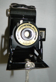
... Kiewa Valley Historical Society Mount Beauty Information Centre 31 Bogong High Plains Rd Mt Beauty high-country This camera was made for the mobile photographer and the camera manufacturer Kodak was at the peak of production. ...This camera was made for the mobile photographer and the camera manufacturer Kodak was at the peak of production. Mr. George Eastman, the company's founder, who invented roll film, which could withstand the outdoor activities and therefor replaced photographic plates. In 1900, the Box Brownie camera was first released Kodak's motto was' "You push the button, we do the rest," The film used in this camera was Kodak Verichrome 620 introduced in 1936 and only went out of production 2009. This camera was a vintage 1970s one. Between 1963 and 1970 the company sold 50 million of this type of camera. The production of smaller and more user friendly digital cameras, mainly from Japan finally nailed the coffin lid on the Kodak Company. Ironically, one of Kodak's engineers called Steve Sasson, devised a camera that could save images using electronic circuits. The images were transferred onto a tape cassette and were viewable by attaching the camera to a TV screen, however Kodak tried to maintain its photographic film products beyond its "use by date". In1975 Kodak becomes the first company to make a digital camera, however the Japanese manufacturers could make smaller and more compact cameras ending Kodak's monopoly and eventual demise.This particular "box brownie" was used by Margaret Shefford, nee Turner, who with her husband retired, in the 1980s, to Mount Beauty. The camera was purchased in the 197's and used on their cruise to England. The significance of this item is that at the time of its introduction to Mount Beauty the camera was a "state of the art", for general public, camera introduced by an ever increasing influx of retirees. This identifies the Kiewa Valley not only as an attraction for sightseers and overseas tourists but also retirees. The social implications of this trend will continue to provide a broader requirement for medical and other facilities geared up to the requirements of an aging population. As a lot of cities in Australia have increasing levels of violence (mainly drug related) rural "retreats" are becoming more sought after by sections of "the gentle populous"This is a black metal rectangular camera, rounded on the ends and has silver colored fittings(stainless steel) and a small leather handle on hinges the left side (facing the lens). The folding lens and shutter component fold out from the main compartment. Two metal arms swing out and hold the lens and collapsible lens body to the required length. When not in use this collapsible (folding) lens extension is fastened to the main body structure providing security and preventing damage to the folding material. The camera has a collapsible eye piece or view finder at the top end. The right hand bottom end has a cylindrical film wider (polished steel). Inside there are two cylindrical cavities, one holding the roll of unexposed film and the other (winder) end a cylinder onto which the unexposed film is wound through for each picture frame. There is a locking mechanism to hold the folding lens structure to the main box structure. See KVHS 0419B for its carrying caseNo external makings but when the lens is folded out it exposes manufacturing information on metal base around the lens " Kodette II B I shutter"(B= Bulb and I= Instant), underneath this, in larger print, is "'FOLDING 'BROWNIE' SIX - 20" below the lens and in smaller print, "made in Great Britain" and underneath this "by KODAK ltd"kodak kodette ii, folding brownie camera, photography, hobby personal item, tourist gadgets. -
 Kiewa Valley Historical Society
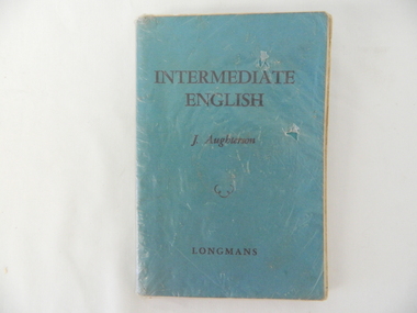
Book - Reference Teaching, Intermediate English J. Aughterson, Circa 1957
... country This particular edition was published in a period (1950s), when textbooks for primary and secondary schools were published by London based publishing houses such as LONGMAN. This particular publishing house brand is now only used by the Longman Schools in China. This reference book was one of the basic reading material for students learning the "English" language opposed to the "Americanised English". The two versions of English now in use are mainly influenced by the greater influx of American based media and the internet. At the time of this publication however print media was at its peak ...This particular edition was published in a period (1950s), when textbooks for primary and secondary schools were published by London based publishing houses such as LONGMAN. This particular publishing house brand is now only used by the Longman Schools in China. This reference book was one of the basic reading material for students learning the "English" language opposed to the "Americanised English". The two versions of English now in use are mainly influenced by the greater influx of American based media and the internet. At the time of this publication however print media was at its peak and the English used was from the United Kingdom. Although the written language is in English, the majority subject matter is of Australian origin. This text book is very significant in demonstrating the type of English taught in rural schools during the period and before the internet and the American based spell check programs now in use. The subtle changes in both the spoken and written English, due to the modern internet facilities, can be seen by the "texting" language of school aged students, post "world wide web" and mobile telephones. This English text book is a moment in time, when the isolation of rural communities had greater affect upon the standard of both the written and spoken language. It was a time when Britain was still thought of as "the mother land" and the English used was that brought to Australian by the original settlers and over time developed an "Australian flavour".Plastic covered soft green colored cardboard cover in black print. Pages (150) are printed in black ink on both sides and in different fonts.Front cover "INTERMEDIATE ENGLISH" underneath "J. Aughterson" underneath a squiggle of three half circles. underneath "LONGMANS". Spine: "AUGHTERSON INTERMEDIATE ENGLISH LONGMANS"school curriculum, secondary education, rural schools -
 Kiewa Valley Historical Society
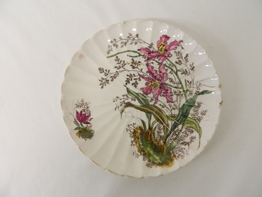
Plate - Gilt, 1870 -1920
... Country Party" ensured that the protection of the rural sector was well entrenched. The ability of the "well off" rural sector, in this period, were not only able to travel abroad but also to purchase expensive items "overseas" cutlery and crockery. The significance of this item is that it highlights a period in time when the "rural" affluence was at its peak ...This gilt plate is from an era where master crockery manufacturers where either located in Britain or Europe.The cost of transportation and the time taken to receive items limited the availability of first class goods. This was an era that was "British is best" in all manufactured goods. With the slow influx of European immigrants European manufactured goods also became of high value. This social requirement was more of a prerequisite for the more affluent rural population, especially at a time when Australia "rode on the sheep's back". Fine British and European goods were a "status symbol", even in rural Australia. After World War II, the invasion of American and Japanese merchandise opened up the market place for cheaper "throw away" items. Longevity and quality of goods fell away as the "throw away" society rolled on.This item demonstrates the time when the rural sector was at its most affluent and influential in dictating the strong ties between Australia, Britain and Europe. The very influential "Country Party" ensured that the protection of the rural sector was well entrenched. The ability of the "well off" rural sector, in this period, were not only able to travel abroad but also to purchase expensive items "overseas" cutlery and crockery. The significance of this item is that it highlights a period in time when the "rural" affluence was at its peak.This hand painted floral gilt plate is a cream fluted china plate decorated with pink and yellow orchid flower arrangement. It is in the "Art Nouveau" period 1880-1920.underneath and within the circular base and in gold freehand script "4" underneath "1562". Pressed into the base is the manufacturer's monogram.Circled around the FAM mark is "* FRANZ ANT. MEHLEM*BONN A/RHEIN*"hand painted china, floral gilt plate, decorative china -
 Kiewa Valley Historical Society
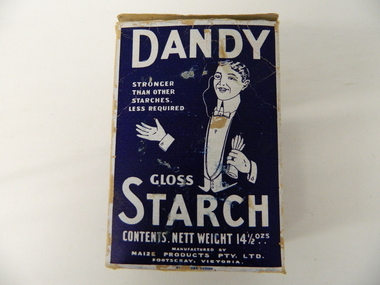
Box Starch, circa 1914 to late 1900's
... Kiewa Valley Historical Society Mount Beauty Information Centre 31 Bogong High Plains Rd Mt Beauty high-country This brand of starch was first manufactured in 1914, during the First World War, and continued to cover the other wars and military conflicts that followed. It was a time when Australian made was important due to the limited supplies coming from England and Europe. This was a period when the demand for "home grown" produce was at its peak ...This brand of starch was first manufactured in 1914, during the First World War, and continued to cover the other wars and military conflicts that followed. It was a time when Australian made was important due to the limited supplies coming from England and Europe. This was a period when the demand for "home grown" produce was at its peak. This was in a time when by necessity not by the "Buy Australian" campaign (of later years) which was the major factor for the demand of goods. It was in a time when starch was used in formal clothing to put a "crisp" or fresh new appearance for clothes. The important social more of "clothes make the person" was in vogue.This box which once contained starch powder is very significant to a rural semi isolated region because it clearly demonstrates that the social mores of the city were also entrenched into the rural population. The fashion of the day, even in remote areas, especially rural, were still a requirement to be maintained on certain special occasions. Cleanliness and stiff "upper lip" persona were just as important in the rural sector as in city and Government circles. Institutions such as hospitals, Government Offices and the legal personnel were bound by the fashion of the starch appearance (no dirt sticks to a personage with the "starch" look). Appearances, especially the first ones, were the judgmental image that remained in the uppermost regions of the viewer. This box with white writing and a "formally clad" man on a navy blue background held Australian grown maize based starch powder(1 LB gross). The package is made from 200 gsm thick cardboard. As production was made during the two World Wars 1914 to 1945 the promotion was heavily focused on Australian made and Australian grown maize.The same cover both front and back, "DANDY" below this a figure outlined in white on a navy blue background "hat and tails" outfit. Next to the sketch in smaller lettering" STRONGER THAN OTHER STARCHES. LESS REQUIRED". Below the figure "GLOSS" and below this in larger print "STARCH". Below this and in smaller print "CONTENTS. NETT WEIGHT 14 1/2 ozs" Below this and in smaller print "MANUFACTURED BY MAIZE PRODUCTS PTY LTD FOOTSCRAY VICTORIA" On one side of the box and in large white print on royal blue background"PURITY, STRENGTH AND UNIFORMITY." On the other side are the manufacturers directions. On the left side "FOR RAW STARCH" Underneath and in smaller print,"Dissolve in warm water a quantity to give the required thickness. Add bluing if required Stir before each using. On the right side "FOR BOILING STARCH" underneath this in small print"Mix well in small quantity of cold water to creamy consistency. Add boiling water, and stir constantly while cooking. Allow to cool, and add blueing if required. Underneath these two sets of instructions is "Make your consistency thinner than if using another kind of Starch"household starch, household cleaning, domestic laundering. -
 Kiewa Valley Historical Society
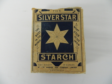
Box Starch, Pre decimal currency date(14th February 1966)
... Kiewa Valley Historical Society Mount Beauty Information Centre 31 Bogong High Plains Rd Mt Beauty high-country This brand of starch was first manufactured before 1966 and covered the period when Australian made was the preferred clothing due to limited imports from England. This was a period when the demand for "home grown" produce was at its peak ...This brand of starch was first manufactured before 1966 and covered the period when Australian made was the preferred clothing due to limited imports from England. This was a period when the demand for "home grown" produce was at its peak. This was in a time when by necessity and ease of supply and not by the "Buy Australian" campaign (of later years), was the major factor for the demand of these type of laundry goods. It was in a time when starch was used in formal clothing to put a "crisp" or fresh new appearance for clothes. This product was in the era and importantly the social more of "clothes make the person" in which starched shirts and dresses was the fashion vogue. Formality of dress was a strictly British "class" up-man-ship which from the 1950's onwards became less and less visible. The Australian "Ocker" or fair "dink'm" bloke became more entrenched after World War II. The national identity was slowly developing.This box of starch is very relevant to the Kiewa Valley because this box highlights the differences ,in this period, between city and rural social standards. Rural areas were deeply entrenched into colonial and the pioneer family structure viz- a-vie social and dress fashion standards. British values and norms lingered on well beyond the changes happening in city fashion. Tradition and English "ties" were the backbone of early colonies and it was only after World War II that these "ties" were becoming irrelevant. Early traditions lingered well past the independence sought by Federation, colony to statehood and trade with other nations eg. USA and Asia. The idea that a change in "status" would automatically change the social mores of Australians, especially in rural ares, was not fully grasped by the "law makers" and those wanting change.This box (capacity 12 ozs) has white(aged into cream) and blue printing and a "white star" on five sides, the sixth side has a laundry scene with two ladies, in early 1900's fashion. The package is made from 200 gsm thick cardboard. As manufacture was made before and during the two World Wars 1914 to 1945 the promotion was heavily focused on Australian made and Australian grown maize. One side of the box has instructions of use and all the other sides are promotional, detailing "the best in the world and won't stick to the iron""SILVER STAR", "THE BEST IN THE WORLD", "WON'T STICK TO THE IRON", "REQUIRES NO BOILING", INSTRUCTIONS FOR USE", "ROBERT HARPER AND COMPANY LIMITED", "INCORPORATED IN VICTORIA, AUSTRALIA", "NET WEIGHT 12 OUNCES", "LARGE BOX 12 OZS"domestic laundry essentials, cotton clothing preparations, household starch "crisp and neat appearances. -
 Kiewa Valley Historical Society
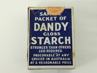
Box Sample Dandy Starch, circa mid to late 1900's
... Kiewa Valley Historical Society Mount Beauty Information Centre 31 Bogong High Plains Rd Mt Beauty high-country This brand of starch was first manufactured in 1914, during the First World War, and continued to cover the other wars and military conflicts that followed. It was a time when Australian made was important due to the limited supplies coming from England and Europe. This was a period when the demand for "home grown" produce was at its peak ...This brand of starch was first manufactured in 1914, during the First World War, and continued to cover the other wars and military conflicts that followed. It was a time when Australian made was important due to the limited supplies coming from England and Europe. This was a period when the demand for "home grown" produce was at its peak. This was in a time when by necessity not by the "Buy Australian" campaign (of later years) which was the major factor for the demand of goods. It was in a time when starch was used in formal clothing to put a "crisp" or fresh new appearance for clothes. The important social more of "clothes make the person" was in vogue. This is a sample box provided by the manufacturer as an advertising and promotional method of prospective customers becoming aware of the product. This type of promotional avenue brought results and ensured that this type of advertising and inducement by manufacturers would be ingrained as a lasting avenue through to the 2nd Millennium This box which once contained starch powder is very significant to a rural semi isolated region because it clearly demonstrates that the social mores of the city were also entrenched into the rural population. The fashion of the day, even in remote areas, especially rural, were still a requirement to be maintained on certain special occasions. Cleanliness and stiff "upper lip" persona were just as important in the rural sector as in city and Government circles. Institutions such as hospitals, Government Offices and the legal personnel were bound by the fashion of the starch appearance (no dirt sticks to a personage with the "starch" look). Appearances, especially the first ones, were the judgmental image that remained in the uppermost regions of the viewer.This box with white writing and a "formally clad" man on a navy blue background held Australian grown maize based starch powder(1 LB gross). The package is made from 200 gsm thick cardboard. As production was made during the two World Wars 1914 to 1945 the promotion was heavily focused on Australian made and Australian grown maize.The front(has "Sample" on top) the rest inscriptions are the same on each cover both and back, "DANDY" below this a figure outlined in white on a navy blue background "hat and tails" outfit. Next to the sketch in smaller lettering" STRONGER THAN OTHER STARCHES. LESS REQUIRED". Below the figure "GLOSS" and below this in larger print "STARCH". Below this and in smaller print "CONTENTS. NETT WEIGHT 14 1/2 ozs" Below this and in smaller print "MANUFACTURED BY MAIZE PRODUCTS PTY LTD FOOTSCRAY VICTORIA" On one side of the box and in large white print on royal blue background"PURITY, STRENGTH AND UNIFORMITY." On the other side are the manufacturers directions. On the left side "FOR RAW STARCH" Underneath and in smaller print,"Dissolve in warm water a quantity to give the required thickness. Add bluing if required Stir before each using. On the right side "FOR BOILING STARCH" underneath this in small print"Mix well in small quantity of cold water to creamy consistency. Add boiling water, and stir constantly while cooking. Allow to cool, and add blueing if required. Underneath these two sets of instructions is "Make your consistency thinner than if using another kind of Starch"household starch, household cleaning, domestic laundering. -
 Emerald Museum & Nobelius Heritage Park
Booklet, Dr D G Hessayon and P. G. Fenemore, Potato Growers Handbook, c. 1960s
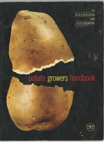
... country due to the deep volcanic soil. Gembrook became the centre of the local potato industry from the 1930s with newly arrived Italian migrants becoming successful potato growers there. The peak...country due to the deep volcanic soil. Gembrook became the centre of the local potato industry from the 1930s with newly arrived Italian migrants becoming successful potato growers there. The peak ...The Dandenongs have historically been regarded as good potato growing country due to the deep volcanic soil. Gembrook became the centre of the local potato industry from the 1930s with newly arrived Italian migrants becoming successful potato growers there. The peak period for potato growing in Gembrook was the 1970s and 1980s. This handbook for growing potatoes whilst produced in England and referencing English conditions may have been helpful for some local growers.Potato growing was an important local industry, particularly in Gembrook, from the late 19th century to the 1980s.Booklet divided into eight chapters about selecting and growing potatoes and getting them to market. Colored and black and white drawings, maps, graphs and photographs. 34 pages.On front cover: 'BY / DR. D. G. HESSAYON / AND / P. G. FENEMORE / potato growers handbook / 3/6d' On back cover are publisher details.potato growing, gembrook -
 The Beechworth Burke Museum
Photograph, Between 1946 and 1961
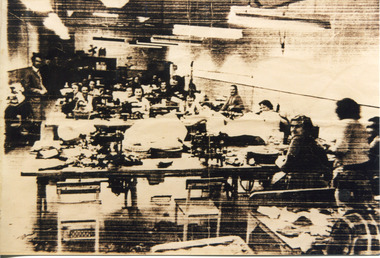
... peak, the shoe factory employed thirty six women and girls, which also included post-war migrants. After the Second World War, Australia admitted increasing numbers of immigrants in order to fulfil labour requirements for a rapidly inflating demand of consumer goods. These migrants were largely from European Countries...country Elgin Shoes Pty., Ltd., established a branch shoe factory in Beechworth in 1946. Managing director, Mr T Nagle Pitman, selected Beechworth as a suitable location for the factory due to the availability of labour in the town, particularly girls under sixteen years of age. At its peak ...Elgin Shoes Pty., Ltd., established a branch shoe factory in Beechworth in 1946. Managing director, Mr T Nagle Pitman, selected Beechworth as a suitable location for the factory due to the availability of labour in the town, particularly girls under sixteen years of age. At its peak, the shoe factory employed thirty six women and girls, which also included post-war migrants. After the Second World War, Australia admitted increasing numbers of immigrants in order to fulfil labour requirements for a rapidly inflating demand of consumer goods. These migrants were largely from European Countries in line with the ‘White Australia Policy’. In 1954 Beechworth had 170 migrants from the UK, 102 from Hungary, and 63 from Germany. The factory closed in 1961 as increased centralisation of both populations and industry in the larger nearby towns of Wangaratta and Wodonga lead to the closure of many factories in small towns in the 1960s and 1970s. This photograph is historically significant as it shows the working conditions in a factory primarily staffed by women at some point between the late 1940s and early 1960s. Sepia rectangular photograph printed on matte photographic paperReverse: 14 / AFGA / 6982 / pitman shoe factory, elgin shoe company, industry, shoe factory, shoemaking, working women, post-war migration, factory, white australia policy, mid-twentieth century women's working conditions, twentieth-century working conditions, pitman, elgin, shoe, sewing machine, leather, pittman -
 The Beechworth Burke Museum
Photograph
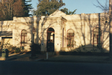
... country This photograph depicts the façade of the Burke Museum in Beechworth. Originally built in 1857 by the Young Men's Association as the Beechworth Athenaeum, the building provided a public lecture hall and reading room for men at the peak of the gold rush era of Beechworth. ...This photograph depicts the façade of the Burke Museum in Beechworth. Originally built in 1857 by the Young Men's Association as the Beechworth Athenaeum, the building provided a public lecture hall and reading room for men at the peak of the gold rush era of Beechworth. In 1859, it became the Beechworth Public Library, which is why the writing embossed above the main entry says 'Library' rather than 'Museum'. The building was turned into a museum and renamed the Robert O'Hara Burke Memorial Museum in 1863 following the death of Robert O'Hara Burke on the Burke and Wills expedition in 1861, as Burke had been the Police Superintendent of Beechworth. The museum has had several additions built onto the property, most notably significant extensions in the 1970s, but the main façade depicted in the photograph has remained largely intact. The architecture is an example of provincial conservative classicism. The Burke Museum contains over 30,000 individual objects, including Gold Rush era items, taxidermy specimens, a Ned Kelly collection, and this very photograph.The Burke Museum itself is very significant to Victorian history. It is on both the Victorian Heritage Register and is part of the National Trust due to its relevance to the history of the Gold Rush period, its architectural features, and its significant collection. Photographs of it throughout its history are an important part of telling the museum's story. Although this is a modern photograph, it captures the façade of the building with similarity to the mid-nineteenth-century provincial conservative classicism style.A colour rectangular photograph printed on photographic paper.3440.1burke museum, beechworth, beechworth museum, australian museum, museum, architecture, classical architecture, conservative classicism, museum facade, library -
 The Beechworth Burke Museum
Photograph, 2000
... The Beechworth Burke Museum Loch Street Beechworth high-country Woolshed is a small area about five kilometres north west of Beechworth, and almost about 225km north east of Melbourne. When gold was discovered at the nearby Spring Creek in February 1852, Woolshed was one of three settlements set up to house miners and their families. At its peak ...Woolshed is a small area about five kilometres north west of Beechworth, and almost about 225km north east of Melbourne. When gold was discovered at the nearby Spring Creek in February 1852, Woolshed was one of three settlements set up to house miners and their families. At its peak in 1857, Woolshed was also populated by 29 storekeepers and 14 hotels, as well as the Woolshed State School, which stood near where this photograph was taken. The school often played host to public meetings, as well as a public dance in 1897. The school was subject to some controversy in 1874 when one parent complained about the head of the school in the local newspaper, the Owens and Murray Advertiser, and at least three letters to the editor were exchanged between the two. According to the parent, C. O'Donoghue was not providing enough amusement for the children and was disrespectful to parents and staff. When the State Governor, Sir Reginald Talbot, visited Beechworth in 1906, the school organised a celebratory welcome. The Woolshed State School was ultimately closed in 1922 as miners had exhausted the Spring Creek gold supply and were moving elsewhere. This photograph, taken in about 2000, shows the trees that grew on or near the site of the original school. The Woolshed State School Honour Roll, with a list of the men from the school who served in the First World War, also still exists. It is stored in the Beechworth RSL as of 2015.This photograph is significant for its connection to an important site in Beechworth's gold mining history. Woolshed served a significant community of miners, with a population of at least 138 according to the 1911 census, with families that needed the school site to ensure their children's education. The image is also useful for prompting discussion about how Beechworth has changed over time, with the photograph taken 78 years after the school closed down.A colour rectangular photograph printed on glossy photographic paper.Woolshed State. / School site / 2000 / - remnant trees / / cobeechworth, burke museum, school, education, trees, nature, state school, woolshed, gold mining, teachers, over time, owens and murray advertiser, public meetings, public dance, c. o'donoghue, spring creek, state governor, sir reginald talbot, miners, honour roll, world war 1 -
 The Beechworth Burke Museum
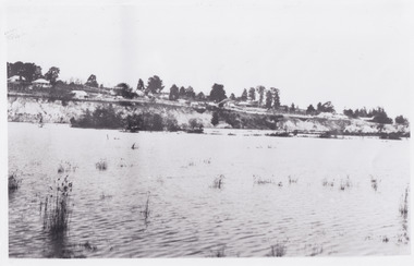
Photograph
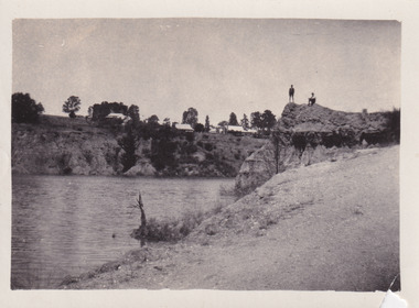
... peak of Victoria’s Gold Rush. It was converted into a park and leisure area in the 1920s. Lake Sambell was formally opened to the public on Friday 5th October 1928 and was opened by the Victorian Government’s Minister of Lands, Mr Bailey, as part of initiatives to boost the economies and development of country towns. ...country The photograph depicts two young men standing atop a prominent outcrop at Lake Sambell, with buildings visible on the further shore. The present day park and reserve occupies the site of the former Rocky Mountain Mining Company, an open-cut sluice mine that began operations in the mid-Nineteenth Century and operated until the early 1900s, through the peak of Victoria’s Gold Rush. ...The photograph depicts two young men standing atop a prominent outcrop at Lake Sambell, with buildings visible on the further shore. The present day park and reserve occupies the site of the former Rocky Mountain Mining Company, an open-cut sluice mine that began operations in the mid-Nineteenth Century and operated until the early 1900s, through the peak of Victoria’s Gold Rush. It was converted into a park and leisure area in the 1920s. Lake Sambell was formally opened to the public on Friday 5th October 1928 and was opened by the Victorian Government’s Minister of Lands, Mr Bailey, as part of initiatives to boost the economies and development of country towns. The lake was named after Mr L.H. Sambell, a shire engineer and secretary of the Forward Beechworth Committee who was involved in promoting the transformation of the mining site and promoting plantation forestry and tourism as alternative industries. £300 to begin the process was provided by Mr J. McConvill, a former resident of Beechworth, who is remembered in a street name adjacent to the lake. An article in the Ovens and Murray Advertiser on Saturday, 5th May, 1917, gives some insight into issues in the Rocky Mountain Mining Company’s final years. The writer details the 1917 annual meeting of the Rocky Mountain Mining Company, stating that locals present appeared ‘well pleased this important local industry is in such a prosperous condition and that future prospects are so encouraging’. The author describes plans to give workers a bonus as evidence of profit-sharing that would ‘bridge the gulf between capital and labour’. The article concludes, however, with the statement that ‘there is a little arithmetical puzzle in the report in connection with the dredging operations I have been unable to solve.' The photograph is significant as it contributes to knowledge about how Beechworth reinvented itself after the Gold rush period, and more broadly how country towns repurpose and redevelop infrastructure and facilities to meet the present needs of their population. Sepia rectangular photograph printed on matte photographic paper. Obverse: nil. Reverse: 3471 / Velox (paper mark)beechworth, beechworth lake, lake sambell, l.h. sambell, mcconvill, rocky mountain mining company, rocky mountain mining co, minister of lands, forward beechworth committee, wallace park-lake sambell development scheme, wallace park lake sambell development scheme, lake, sambell, j. mcconvill, recreation, reserve, park, transformation, repurposed, redeveloped -
 The Beechworth Burke Museum
Photograph, c1960
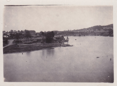
... peak of Victoria’s Gold Rush. It was converted into a park and leisure area in the 1920s. Lake Sambell was formally opened to the public on Friday 5th October 1928 and was opened by the Victorian Government’s Minister of Lands, Mr Bailey, as part of initiatives to boost the economies and development of country towns. ...country The photograph depicts a view across the water at Lake Sambell. The image dates from approximately 1960. The present day park and reserve occupies the site of the former Rocky Mountain Mining Company, an open-cut sluice mine that began operations in the mid-Nineteenth Century and operated until the early 1900s, through the peak of Victoria’s Gold Rush. ...The photograph depicts a view across the water at Lake Sambell. The image dates from approximately 1960. The present day park and reserve occupies the site of the former Rocky Mountain Mining Company, an open-cut sluice mine that began operations in the mid-Nineteenth Century and operated until the early 1900s, through the peak of Victoria’s Gold Rush. It was converted into a park and leisure area in the 1920s. Lake Sambell was formally opened to the public on Friday 5th October 1928 and was opened by the Victorian Government’s Minister of Lands, Mr Bailey, as part of initiatives to boost the economies and development of country towns. The lake was named after Mr L.H. Sambell, a shire engineer and secretary of the Forward Beechworth Committee who was involved in promoting the transformation of the mining site and promoting plantation forestry and tourism as alternative industries. £300 to begin the process was provided by Mr J. McConvill, a former resident of Beechworth, who is remembered in a street name adjacent to the lake. Residents of Beechworth have worked to raise funds to improve the Lake Sambell reserve several times, such as efforts in the 1930s and 1940s to raise the banks several feet to deepen the water for swimming purposes. Fundraising campaigns include the ‘Ugly Man’ competition conducted on behalf of the Wallace Park-Lake Sambell Development Scheme. The latter competition was run by the Fire Brigade Bend’s team as part of a larger competition called the ‘Mile of Pennies’; it was won by Mr Len Knight of Beechworth’s Commercial Hotel. The ‘Mile of Pennies’ was conducted at a Carnival held on New Year’s Eve, 1947. It was proposed by the Beechworth and District Progress Association. As well as improving swimming facilities, funds were raised to install a caravan park facility near the lake. Funds were also donated by commercial entities, such as £250 received from Zwar Bros. Pty Ltd. The photograph is significant as it shows the level of development of Beechworth in the early to mid-Twentieth Century. Sepia rectangular photograph printed on matte photographic paperObverse: nil. Reverse: 3470 / Velox (paper mark)beechworth, beechworth lake, lake sambell, lake, beechworth and district progress association, forward beechworth committee, ugly man, mile of pennies, wallace park lake sambell development scheme, wallace park-lake sambell development scheme, zwar bros, zwar, l.h. sambell, j. mcconvill, minister of lands, commercial hotel, len knight, rocky mountain mining company, rocky mountain mining co, gold rush, redevelopment, transformation, community fundraising -
 The Beechworth Burke Museum
Photograph, c1960
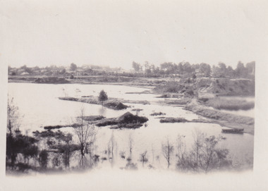
... peak of Victoria’s Gold Rush. It was converted into a park and leisure area in the 1920s. Lake Sambell was formally opened to the public on Friday 5th October 1928 and was opened by the Victorian Government’s Minister of Lands, Mr Bailey, as part of initiatives to boost the economies and development of country towns. ...country The photograph depicts a view across the water at Lake Sambell. The image is thought to date from the 1960s so may show the lake during a period of drought, such as that experienced across South-Eastern Australia in 1967. The present day park and reserve occupies the site of the former Rocky Mountain Mining Company, an open-cut sluice mine that began operations in the mid-Nineteenth Century and operated until the early 1900s, through the peak of Victoria’s Gold Rush. ...The photograph depicts a view across the water at Lake Sambell. The image is thought to date from the 1960s so may show the lake during a period of drought, such as that experienced across South-Eastern Australia in 1967. The present day park and reserve occupies the site of the former Rocky Mountain Mining Company, an open-cut sluice mine that began operations in the mid-Nineteenth Century and operated until the early 1900s, through the peak of Victoria’s Gold Rush. It was converted into a park and leisure area in the 1920s. Lake Sambell was formally opened to the public on Friday 5th October 1928 and was opened by the Victorian Government’s Minister of Lands, Mr Bailey, as part of initiatives to boost the economies and development of country towns. The lake was named after Mr L.H. Sambell, a shire engineer and secretary of the Forward Beechworth Committee who was involved in promoting the transformation of the mining site and promoting plantation forestry and tourism as alternative industries. £300 to begin the process was provided by Mr J. McConvill, a former resident of Beechworth, who is remembered in a street name adjacent to the lake. Residents of Beechworth have worked to raise funds to improve the Lake Sambell reserve several times, such as efforts in the 1930s and 1940s to raise the banks several feet to deepen the water for swimming purposes. Fundraising campaigns include the ‘Ugly Man’ competition conducted on behalf of the Wallace Park-Lake Sambell Development Scheme. The latter competition was run by the Fire Brigade Bend’s team as part of a larger competition called the ‘Mile of Pennies’; it was won by Mr Len Knight of Beechworth’s Commercial Hotel. The ‘Mile of Pennies’ was conducted at a Carnival held on New Year’s Eve, 1947. It was proposed by the Beechworth and District Progress Association. As well as improving swimming facilities, funds were raised to install a caravan park facility near the lake. Funds were also donated by commercial entities, such as £250 received from Zwar Bros. Pty Ltd.The photograph is significant as it shows Lake Sambell at lower water levels, such as may have been experienced during period of drought.Sepia rectangular photograph printed on matte photographic paperObverse: nil Reverse: 3470beechworth, beechworth lake, lake sambell, lake, beechworth and district progress association, forward beechworth committee, ugly man, mile of pennies, wallace park lake sambell development scheme, wallace park-lake sambell development scheme, zwar bros, zwar, l.h. sambell, j. mcconvill, minister of lands, commercial hotel, len knight, rocky mountain mining company, rocky mountain mining co, gold rush, redevelopment, transformation, community fundraising, drought, 1967, 1960s -
 The Beechworth Burke Museum
Photograph, c1960
... peak of Victoria’s Gold Rush. It was converted into a park and leisure area in the 1920s. Lake Sambell was formally opened to the public on Friday 5th October 1928 and was opened by the Victorian Government’s Minister of Lands, Mr Bailey, as part of initiatives to boost the economies and development of country towns. ...country The photographs in this set depict views across the water at Lake Sambell. The images date from approximately 1960. The present day park and reserve occupies the site of the former Rocky Mountain Mining Company, an open-cut sluice mine that began operations in the mid-19th Century and operated until the early 1900s, through the peak of Victoria’s Gold Rush. ...The photographs in this set depict views across the water at Lake Sambell. The images date from approximately 1960. The present day park and reserve occupies the site of the former Rocky Mountain Mining Company, an open-cut sluice mine that began operations in the mid-19th Century and operated until the early 1900s, through the peak of Victoria’s Gold Rush. It was converted into a park and leisure area in the 1920s. Lake Sambell was formally opened to the public on Friday 5th October 1928 and was opened by the Victorian Government’s Minister of Lands, Mr Bailey, as part of initiatives to boost the economies and development of country towns. The lake was named after Mr L.H. Sambell, a shire engineer and secretary of the Forward Beechworth Committee who was involved in promoting the transformation of the mining site and promoting plantation forestry and tourism as alternative industries. £300 to begin the process was provided by Mr J. McConvill, a former resident of Beechworth, who is remembered in a street name adjacent to the lake. Residents of Beechworth have worked to raise funds to improve the Lake Sambell reserve several times, such as efforts in the 1930s and 1940s to raise the banks several feet to deepen the water for swimming purposes. Fundraising campaigns include the ‘Ugly Man’ competition conducted on behalf of the Wallace Park-Lake Sambell Development Scheme. The latter competition was run by the Fire Brigade Bend’s team as part of a larger competition called the ‘Mile of Pennies’; it was won by Mr Len Knight of Beechworth’s Commercial Hotel. The ‘Mile of Pennies’ was conducted at a Carnival held on New Year’s Eve, 1947. It was proposed by the Beechworth and District Progress Association. As well as improving swimming facilities, funds were raised to install a caravan park facility near the lake. Funds were also donated by commercial entities, such as £250 received from Zwar Bros. Pty Ltd.The photographs are significant as they show the level of development in Beechworth in the middle of the Twentieth Century. Four sepia and black and white rectangular photographs printed on matte photographic paper. 3469.1: Obverse: nil Reverse: 3469-1 3469.2: Obverse: nil Reverse: 3469-2 3469.3: Obverse: nil Reverse: 3469-3 3469.4: Obverse: nil Reverse: 3469-4beechworth, beechworth lake, lake sambell, lake, beechworth and district progress association, forward beechworth committee, ugly man, mile of pennies, wallace park lake sambell development scheme, wallace park-lake sambell development scheme, zwar bros, zwar, l.h. sambell, j. mcconvill, minister of lands, commercial hotel, len knight, rocky mountain mining company, rocky mountain mining co, gold rush, redevelopment, transformation, community fundraising -
 The Beechworth Burke Museum
Photograph - Lantern Slide, c1900
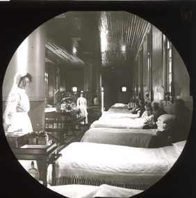
... country This glass slide captures a scene from a male hospital ward at Mayday Hills Mental Asylum. Also known as the Beechworth Lunatic Asylum, Mayday Hills was officially opened on the twenty-fourth of October 1867 and was commissioned following lobbying from Beechworth Municipal Council concerning a need for better living conditions for individuals confined to the town's gaol. These individuals, as well as many others who were brought from surrounding institutions, exhibited behaviours that were deemed to be unfit for mainstream society. At its peak ...This glass slide captures a scene from a male hospital ward at Mayday Hills Mental Asylum. Also known as the Beechworth Lunatic Asylum, Mayday Hills was officially opened on the twenty-fourth of October 1867 and was commissioned following lobbying from Beechworth Municipal Council concerning a need for better living conditions for individuals confined to the town's gaol. These individuals, as well as many others who were brought from surrounding institutions, exhibited behaviours that were deemed to be unfit for mainstream society. At its peak, the asylum consisted of sixty-seven buildings and housed over twelve-hundred patients and five-hundred staff. At the time of Australian Federation in 1901 - just a year after this photograph was taken - the patient population numbered six-hundred and seventy-four. The asylum was officially closed in 1996. It is listed on the Victorian Heritage Register as being architecturally significant. The extensive complex of buildings are examples of Italianate-style, which is strongly associated with asylums of the 1860s - the period in which construction of this particular asylum began. Today the asylum offers tours to visitors, including daytime history tours and night-time ghost tours. Lantern slides, sometimes called 'magic lantern' slides, are glass plates on which an image has been secured for the purpose of projection. Glass slides were etched or hand-painted for this purpose from the Eighteenth Century but the process became more popular and accessible to the public with the development of photographic-emulsion slides used with a 'Magic Lantern' device in the mid-Nineteenth Century. Photographic lantern slides comprise a double-negative emulsion layer (forming a positive image) between thin glass plates that are bound together. A number of processes existed to form and bind the emulsion layer to the base plate, including the albumen, wet plate collodion, gelatine dry plate and woodburytype techniques. Lantern slides and magic lantern technologies are seen as foundational precursors to the development of modern photography and film-making techniques.This glass slide is socially and historically significant as it is representative of the lives of the nurses and patients at Beechworth Mayday Hills Asylum in the early twentieth century. It is also historically significant as it is representative of the changing style of treatments and attitudes towards mental illness. Thin translucent sheet of glass with a circular image printed on the front and framed in a black backing. It is held together by metal strips to secure the edges of the slide.Obverse: h /lantern slide, slide, glass slide, plate, burke museum collection, photograph, monochrome, mayday hills, mayday hills hospital, mayday hills asylum, beechworth lunatic asylum, beechworth mental asylum, psychiatric hostpital, beechworth, burke museum, beechworth municipal council, beechworth patients, psychiatric patients, victorian heritage register, 1900, 1900 mayday hills, italianate style, 19th century asylums, asylums victoria, male ward mayday hills -
 The Beechworth Burke Museum
Photograph - Lantern Slide, c1900
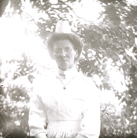
... country Taken in approximately 1900, this glass slide captures an image of a Mayday Hills Mental Asylum nurse. Also known as the Beechworth Lunatic Asylum, Mayday Hills was officially opened on the twenty-fourth of October 1867 and was commissioned following lobbying from Beechworth Municipal Council concerning a need for better living conditions for certain individuals confined to the town's gaol. These individuals, as well as many others who were brought from surrounding institutions, exhibited behaviours that were deemed to be unfit for mainstream society. At its peak ...Taken in approximately 1900, this glass slide captures an image of a Mayday Hills Mental Asylum nurse. Also known as the Beechworth Lunatic Asylum, Mayday Hills was officially opened on the twenty-fourth of October 1867 and was commissioned following lobbying from Beechworth Municipal Council concerning a need for better living conditions for certain individuals confined to the town's gaol. These individuals, as well as many others who were brought from surrounding institutions, exhibited behaviours that were deemed to be unfit for mainstream society. At its peak, the asylum consisted of sixty-seven buildings and housed over twelve-hundred patients and five-hundred staff. At the time of Australian Federation in 1901 - just a year after this photograph was taken - the patient population numbered six-hundred and seventy-four. The designated site of the institution was chosen due to its scenery and altitude. It was argued that these picturesque surroundings would assist in curing the hospital's patients of their ailments. The asylum was officially closed in 1996. It is listed on the Victorian Heritage Register as being architecturally significant. The extensive complex of buildings are examples of Italianate-style, which is strongly associated with asylums of the 1860s - the period in which construction of this particular asylum began. Today the asylum offers tours to visitors: both daytime history tours and night-time ghost tours. Lantern slides, sometimes called 'magic lantern' slides, are glass plates on which an image has been secured for the purpose of projection. Glass slides were etched or hand-painted for this purpose from the Eighteenth Century but the process became more popular and accessible to the public with the development of photographic-emulsion slides used with a 'Magic Lantern' device in the mid-Nineteenth Century. Photographic lantern slides comprise a double-negative emulsion layer (forming a positive image) between thin glass plates that are bound together. A number of processes existed to form and bind the emulsion layer to the base plate, including the albumen, wet plate collodion, gelatine dry plate and woodburytype techniques. Lantern slides and magic lantern technologies are seen as foundational precursors to the development of modern photography and film-making techniques.This glass slide is socially and historically significant as it is representative of the lives of the nurses who worked at Beechworth's Mayday Hills Asylum in the early twentieth century. Thin translucent sheet of glass with a portrait image printed on the front. It is held together by metal strips to secure the edges of the slide.burke museum, beechworth, lantern slide, slide, glass slide, plate, burke museum collection, photograph, monochrome, mayday hills, mayday hills mental asylum, beechworth asylum, beechworth asylum nurses, psychiatric nurses, psychiatric care, 1900 mayday hills, victorian heritage register, italianate style, 19th century asylums, asylums victoria -
 The Beechworth Burke Museum
Photograph - Lantern Slide, c1900
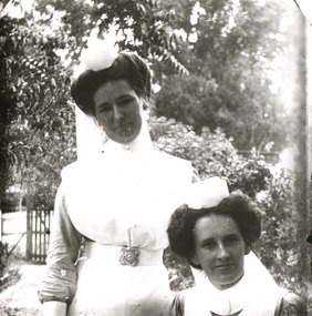
... country Taken in approximately 1900, this glass slide captures an image of two Mayday Hills Mental Asylum nurses. Also known as the Beechworth Lunatic Asylum, Mayday Hills was officially opened on the twenty-fourth of October 1867 and was commissioned following lobbying from Beechworth Municipal Council concerning a need for better living conditions for certain individuals confined to the town's gaol. These individuals, as well as many others who were brought from surrounding institutions, exhibited behaviours that were deemed to be unfit for mainstream society. At its peak ...Taken in approximately 1900, this glass slide captures an image of two Mayday Hills Mental Asylum nurses. Also known as the Beechworth Lunatic Asylum, Mayday Hills was officially opened on the twenty-fourth of October 1867 and was commissioned following lobbying from Beechworth Municipal Council concerning a need for better living conditions for certain individuals confined to the town's gaol. These individuals, as well as many others who were brought from surrounding institutions, exhibited behaviours that were deemed to be unfit for mainstream society. At its peak, the asylum consisted of sixty-seven buildings and housed over twelve-hundred patients and five-hundred staff. At the time of Australian Federation in 1901 - just a year after this photograph was taken - the patient population numbered six-hundred and seventy-four. The designated site of the institution was chosen due to its scenery and altitude. It was argued that these picturesque surroundings would assist in curing the hospital's patients of their ailments. The asylum was officially closed in 1996. It is listed on the Victorian Heritage Register as being architecturally significant. The extensive complex of buildings are examples of Italianate-style, which is strongly associated with asylums of the 1860s - the period in which construction of this particular asylum began. Today the asylum offers tours to visitors: both daytime history tours and night-time ghost tours. Lantern slides, sometimes called 'magic lantern' slides, are glass plates on which an image has been secured for the purpose of projection. Glass slides were etched or hand-painted for this purpose from the Eighteenth Century but the process became more popular and accessible to the public with the development of photographic-emulsion slides used with a 'Magic Lantern' device in the mid-Nineteenth Century. Photographic lantern slides comprise a double-negative emulsion layer (forming a positive image) between thin glass plates that are bound together. A number of processes existed to form and bind the emulsion layer to the base plate, including the albumen, wet plate collodion, gelatine dry plate and woodburytype techniques. Lantern slides and magic lantern technologies are seen as foundational precursors to the development of modern photography and film-making techniques.This glass slide is socially and historically significant as it is representative of the lives of the nurses who worked at Beechworth's Mayday Hills Asylum in the early twentieth century.Thin translucent sheet of glass with a portrait image printed on the front. It is held together by metal strips to secure the edges of the slide.burke museum, beechworth, lantern slide, slide, glass slide, plate, burke museum collection, photograph, monochrome, 1900 mayday hills, mayday hills, beechworth mental hospital, beechworth mental asylum, beechworth asylum nurses, psychiatric nurses, psychiatric care, victorian heritage register, italianate style, 19th century asylums, asylums victoria -
 The Beechworth Burke Museum
Photograph
... countries, did not adopt metal regimental badges during the First World War. All units were issued with the Australian Army General Service Badge, better known as the 'Rising Sun’ badge. This insignia is almost always identified with the Australian Imperial Force. Sport has always been entwined with war. Both sport and war demand peak...countries, did not adopt metal regimental badges during the First World War. All units were issued with the Australian Army General Service Badge, better known as the 'Rising Sun’ badge. This insignia is almost always identified with the Australian Imperial Force. Sport has always been entwined with war. Both sport and war demand peak ...Taken some time between 1914-18, depicted is a large group of unidentified males. Four of them are dressed in Australian military uniforms. The remaining 19 men are dressed in striped uniforms. The male in the centre of the front row is cradling a football, suggesting that the group was part of a football or rugby league team. It is believed that the soldiers in this photograph were part of the Australian Imperial Force. This can be inferred by the chevron rank insignia visible on their uniforms. The placement of this insignia on the sleeve of the right arm suggests that this soldier was either a Warrant Officer or a Non-Commissioned Officer (NCO). Additionally, they are also wearing 'Rising Sun' collar badges on their coats. Australia, unlike most other Commonwealth countries, did not adopt metal regimental badges during the First World War. All units were issued with the Australian Army General Service Badge, better known as the 'Rising Sun’ badge. This insignia is almost always identified with the Australian Imperial Force. Sport has always been entwined with war. Both sport and war demand peak physical fitness, camaraderie, strategy, and allegiance to a team collaboratively working towards a common goal: to win. The connection between sport and war is especially strong in Australia since these two concepts form the basis of our national identity. The Australian War Memorial has a number of World War I recruitment posters linking war and sport in its collection. One of the posters produced in 1915 by the State Parliamentary Recruiting Committee in Victoria attempted to shame young men into enlisting by juxtaposing the image of an Australian soldier standing guard over his deceased mate with a photograph of a Victorian Football League match. Another poster, produced in 1917, features vignettes of different sports including cricket, bowling, boxing, kayaking and golf. Its slogan reads, "Join Together - Train Together - Embark Together - Fight Together: Enlist in the Sportman's 1000".The record is historically significant due to its connection to World War I. This conflict is integral to Australian culture as it was the single greatest loss of life and the greatest repatriation of casualties in the country's history. Australia’s involvement in the First World War began when the Australian government established the Australian Imperial Force (AIF) in August 1914. Immediately, men were recruited to serve the British Empire in the Middle East and on the Western Front. The record has strong research potential. This is due to the ongoing public and scholarly interest in war, history, and especially the ANZAC legend, which is commemorated annually on 25 April, known as ANZAC Day. Additionally, the record presents a unique opportunity to further explore the relationship between the arts, sport and war. This statement of significance has already established that war is integral to Australia's national identity - and sport is of equal importance. Specifically, the record begs to question how the peak physical fitness and camaraderie valued in team sports were creatively translated into military recruitment campaigns during World War I. Evidently, this record and its historic context demonstrates that there is potential here, and if further research is completed on this topic, it may provide insight into Australian military recruitment tactics used in the past and present, and into the future.Sepia rectangular photograph printed on matte photographic paper mounted on card.Reverse: 6529 / hyossest (?) / (?)1/11/1 /military album, army, military, war, wwi, world war i, sport, football, rugby, aif, australian imperial force -
 Halls Gap & Grampians Historical Society
Newspaper - B/W
... peaks of the Grampian Mountains in Victoria. She was visited by thousands in her time, many of whom returned year after year to enjoy her hospitality. I first visited her 40 years ago and she won my heart from the moment I saw her. In those days, guest houses were in their prime - motels were unheard of. To this day, I can recall the delicious meals at "Myrtlebank" with pure country...peaks of the Grampian Mountains in Victoria. She was visited by thousands in her time, many of whom returned year after year to enjoy her hospitality. I first visited her 40 years ago and she won my heart from the moment I saw her. In those days, guest houses were in their prime - motels were unheard of. To this day, I can recall the delicious meals at "Myrtlebank" with pure country ...She was a guest house called "Myrtlebank" and she was a very gracious old residence in a near perfect setting, surrounded by the towering peaks of the Grampian Mountains in Victoria. She was visited by thousands in her time, many of whom returned year after year to enjoy her hospitality. I first visited her 40 years ago and she won my heart from the moment I saw her. In those days, guest houses were in their prime - motels were unheard of. To this day, I can recall the delicious meals at "Myrtlebank" with pure country cream and home grown produce featuring largely. All the guests would gather in the enormous sitting rooms warmed by huge log fires in colder weather and , in the evenings, all sorts of games would be played, charades being first favourite with young and old alike. Several days a week a bus would pick up guests, along with those from other guest houses, and surrounding areas would be visited. Mostly, though, we walked - sometimes right across behind the Wonderland Range to Mount Victory. Now, "Myrtlebank" is no more. The site where she once stood is at the bottom of the Bellfield Lake, covered forever with fathoms of water. But I and many others will always remember and love her. Letter to paper with photograph of MyrtlebankSubmitted by Mrs O. Woolcock, Tottenham Vic who won $15 prize describing accomodation for guests at Myrtlebankaccommodation, guesthouses, myrtlebank