Showing 54 items matching "time tunnel"
-
 Federation University Historical Collection
Report, Concept and Market Study for the Development of a Time Tunnel in Hamilton
... Concept and Market Study for the Development of a Time Tunnel in Hamilton......time tunnel...Barker Library (top floor) Mount Helen goldfields victorian tourisim industry tourism hamilton time tunnel population agricultural history ansett aviation reginald hamilton aboriginal mount eccles dhauwurd wurrung gundidjmara lake condah lutheran german tarrington tetrapods Report compiled by six students of Tourism at University of Ballarat (later Federation University Australia) Concept and Market Study for the Development of a Time Tunnel in Hamilton Report Heather Clapman Amanda Lockey Sallie Ridgeway Emma Condon Ben Matthews Catherine Scott ...Report compiled by six students of Tourism at University of Ballarat (later Federation University Australia)victorian tourisim industry, tourism, hamilton, time tunnel, population, agricultural history, ansett, aviation, reginald hamilton, aboriginal, mount eccles, dhauwurd wurrung, gundidjmara, lake condah, lutheran, german, tarrington, tetrapods -
 Sunshine and District Historical Society Incorporated
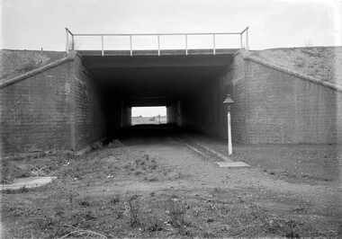
Photograph - Ashley Street Railway Underpass Photographs
... tunnel extension. During these works the road surface level was lowered to allow for higher trucks to pass through. At this point of time...tunnel extension. During these works the road surface level was lowered to allow for higher trucks to pass through. At this point of time ...The Tottenham Yard began as a modest goods yard supporting local industries in Braybrook, Tottenham, and West Footscray, the Sunshine industrial belt and the nearby munitions and explosives factories Key features of the early yard included a small number of sidings, a goods shed, a basic loading / unloading facilities and a connection to the Tottenham triangle (Sunshine–Footscray–North Melbourne junction). As the yard expanded with additional siding and larger marshalling areas, there was a requirement to maintain the Ashley Street North – South access route for private and commercial travel. The work involved to solve this problem was to elevate the railway yard and place Ashley Street through a tunnel. This railway underpass for many years was simply known as the Ashley Street Tunnel. By the 1970s, the Tottenham Yard had become one of the largest freight yards in Victoria, second only to Dynon. In the 1982, the level crossing gates at the southern end of tunnel were removed, the tunnel extended southwards and the former Tottenham Railway Station was replaced with an elevated one above the new tunnel extension. During these works the road surface level was lowered to allow for higher trucks to pass through. At this point of time, the reference to tunnel was replaced with underpass. During the 1990’s and 2000’s, there was a decline in the use of the Tottenham Yard and many sidings were removed, shorten, converted to storage or left unused. Today the yard is used for wagon storage, crew changes, light shunting and providing access to the Tottenham triangle and Sunshine corridor.These photographs were taken shortly after the tunnel was completed.5335.01 - Ashley Street Railway Underpass Looking North Photo 01.jpg 5335.02 - Ashley Street Railway Underpass Looking South Photo 02.jpgashley street, railway line, tottenham -
 Warrnambool and District Historical Society Inc.
Financial record - Ledger: Warrnambool Water works Trust, Circa 1900
... Timor and Liebig Streets where a stand pipe allowed the filling of water carts. Similar supplies were also installed at Albert Park, the Botanic Gardens and the Cattle markets and from 1893 to 1939 water was drawn from the Merri River. Drainage works commenced with the building of the Japan Street tunnel...Timor and Liebig Streets where a stand pipe allowed the filling of water carts. Similar supplies were also installed at Albert Park, the Botanic Gardens and the Cattle markets and from 1893 to 1939 water was drawn from the Merri River. Drainage works commenced with the building of the Japan Street tunnel ...This ledger contains entries which relate to waterworks and associated expenses: construction, pumping schemes, water from stand pipes, meter rent arrears, interest payments, pumping scheme. Early residents in Warrnambool relied on tanks and wells for their water supply and in 1880 the first water supply scheme was implemented from a well on Cannon Hill. Using a windmill the water was pumped up and stored in a small reservoir nearby then piped to the corner of Timor and Liebig Streets where a stand pipe allowed the filling of water carts. Similar supplies were also installed at Albert Park, the Botanic Gardens and the Cattle markets and from 1893 to 1939 water was drawn from the Merri River. Drainage works commenced with the building of the Japan Street tunnel in 1856. The Warrnambool Waterworks Trust was the body responsible for administering these works.The supply and storage of fresh water and drainage of the area was an important factor in the development and sustainability of the town. This ledger provides an insight into the daily operations of this organisation. Large suede covered journal. Tan in colour with pink, green and white on edge of pages. Faded black stylised border around front cover. Inside front covers are patterned in green and tan. Printed sheet with Warrnambool waterworks Trust is pasted inside front cover. Warrnambool Waterworks Trust stamp on sheet inside front cover.warrnambool water works, warrnambool water supply 1900, warrnambool water works ledger 1900, warrnambool waterworks trust -
 Kiewa Valley Historical Society
Photo - Junction Dam Diversion Tunnel
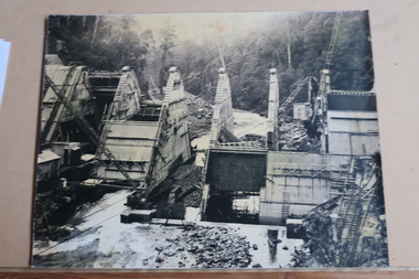
... However time has demonstrated that these power stations have not matched the demand required by the industries and the populations of the major urban and cities. Bogong SECV Junction Dam Lake Guy Handwritten on back - Junction Dam Diversional Tunnel Black and white photograph of Junction Dam diversion tunnel at Bogong Village Photo - Junction Dam Diversion Tunnel ...Junction (Lake Guy) Dam is a 'slab and buttress' type wall. A timber frame is built and then filled with concrete. The first batch of concrete was placed in September, 1940. By June, 1941 the buttresses were finished to a height safe from floods and in October of that year a flood of 2,800 cusecs occurred but with only slight damage to the installations. Industrial trouble caused some delays but there was also slow progress on the part of the contractor and the work was taken over by the S.E.C., terminating the contract. The dam was completed in March, 1944. A walkway was made through the dam wall. Lake Guy was named after Mr. L.T. Guy who was the Resident engineer, in charge of construction work and associated activities on the Kiewa Area from 1939 to November 1946.Diversion dams are installed to raise the water level of a body of water to be redirected. The redirected water is used for hydro electric power generation. A diversion tunnel is usually bored through solid rock next to the dam site to bypass the dam construction site. The dam is built while the river flows through the diversion tunnel.Photos of the construction of the Junction Dam detail the harsh conditions faced by construction workers, building dams and villages to accommodate workers in the 1940s to the 1950s. Australia at this period in time, experienced a surge of population (influx of World War II refugees), which was the catalyst for developing and undergoing an enormous hydroelectricity program for the Alpine regions, both in Victoria and New South Wales. This program was initiated to supply electricity to the major southern Australian cities of Adelaide, Melbourne and Sydney. It was thought that these developments would reduce, if not eliminate, the requirement for coal driven power stations. However time has demonstrated that these power stations have not matched the demand required by the industries and the populations of the major urban and cities.Black and white photograph of Junction Dam diversion tunnel at Bogong VillageHandwritten on back - Junction Dam Diversional Tunnelbogong, secv, junction dam, lake guy -
 Kiewa Valley Historical Society
Report - Alpine Study Area Volume 2 Maps, Land Conservation Council, 1970s
... time the maps were created. Some of the topics eg. Rainfall and water resources may change over the years thus providing a comparative analysis. Others may provide information for future development such as mineral exploration, building of a dam / tunnel etc. alpine area maps of alpine area land conservation council Ex library item. ...The Victorian Environmental Assessment Council and the former Environment Conservation Council (ECC) and Land Conservation Council (LCC) have completed 36 land use investigations over more than 35 years, including 27 regional reviews. They provide a framework for use of Public Land in Victoria. The Land Conservation Council was established by the Land Conservation Act 1970.These maps provide an assessment of the Alpine area at the time the maps were created. Some of the topics eg. Rainfall and water resources may change over the years thus providing a comparative analysis. Others may provide information for future development such as mineral exploration, building of a dam / tunnel etc.Blue box shaped folder containing 9 of 10 Maps of the Alpine Study Area produced by the Land Conservation Council. Maps include 1. Public land and descriptive blocks. 2. Physiography. 3. Topography. 4. Geology (missing). 5. Rainfall and water resources. 6. Vegetation 7. Land systems. 8. Recreation. 9. Primary production. 10. Minerals Ex library item. Stamped in red "Discarded From Stock / Swan Hill Regional Libraryalpine area, maps of alpine area, land conservation council -
 Kiewa Valley Historical Society
Photograph - Folder of Photographs (KVHS 1150 A - F) – Photocopied set of black and white photographs from the display folder (pages 1 - 8) put together by KVHS to document life on the Kiewa Valley Hydro-electric Scheme
... Diverting East Kiewa River into Channel Page number 1 4-STATE ELECTRICITY COMMISSION OF VICTORIA Date: 5.4.40 Time: Noon No K58 Kiewa Hydro Electric Works. Junction Dam – Diversion Tunnel Inlet – Normal Flow Page number 2 5- STATE ELECTRICITY COMMISSION OF VICTORIA Date: 19.8.42 Time: 2.30pm No K883 Kiewa Hydro Electric Works. ...Diverting East Kiewa River into Channel Page number 1 4-STATE ELECTRICITY COMMISSION OF VICTORIA Date: 5.4.40 Time: Noon No K58 Kiewa Hydro Electric Works. Junction Dam – Diversion Tunnel Inlet – Normal Flow Page number 2 5- STATE ELECTRICITY COMMISSION OF VICTORIA Date: 19.8.42 Time: 2.30pm No K883 Kiewa Hydro Electric Works. ...Although the Kiewa Hydro-Electric Scheme was first proposed in 1911, construction did not commence until 1938. As part of the push to cut electricity costs and diversify supply, the Victorian Government (circa 1930) initiated the conversion from primarily brown coal supply to hydro – electricity. Field investigations during the 1940’s resulted in a new proposal for a scheme that had more than double the capacity of the 1938 scheme. The Kiewa Hydroelectric Scheme became the largest scheme of its kind in the State Of Victoria and the second largest scheme in Australia. The number of personnel involved in the planning and construction of the scheme increased dramatically. During the late 1940’s, most activity centred around the construction of the West Kiewa Power Station, Rocky Valley Reservoir, McKay Creek Power Station and the Bogong Creek Aqueduct.A common thread across all the larger hydro scheme constructions was the need for workers, both qualified and unqualified who came from around the world seeking a new life for themselves and their families. New accommodation and facilities were required for the army of workers engaged in construction in often remote and wild areas. The SEC had a high demand for timber, and set up the first of a number of sawmills at Bogong Creek in 1939 and set up the first hardwood logging in the headwaters of the Kiewa River. These new ‘towns’ such as Mt Beauty and Bogong, survived, serving the needs of operational personnel and their families, and expanding with growth of new industries. Mount Beauty, and to a lesser extent Bogong, are among these places. Large A3 size spiral bound display folder containing 21 of 58 pages of photocopied black and white photographs of various aspects of the early days of the Kiewa Valley Hydro-electric scheme including equipment, various work sites and photographs of workers and their families. 1-Front page; 2-Security gate at Mt Beauty Camp; 3-Channel 1 on East Kiewa River; 4-Junction Dam – Diversion Tunnel Inlet; 5-Sawmill; 6- Homan’s Gap Sawmill; 7 Junction Dam: 8-Homan Dam Site-Diamond Drilling on River Buttress; 9- Homan Dam Site View Upstream 10-Homan Dam Investigation Camp 1-Windsor & Newton Visual Diary 60 sheet (120 pages) 11’ x 14’ 280 x 356mm 110 GSM Acid Free Drawing Paper 2-1940-Security Gate on Mt Beauty side of Kiewa River bridge. Part of old Mt Beauty camp and mess in background 3- STATE ELECTRICITY COMMISSION OF VICTORIA Date; 11.3.40 Time: 10.30am No K35 Kiewa Hydro Electric Works. Diverting East Kiewa River into Channel Page number 1 4-STATE ELECTRICITY COMMISSION OF VICTORIA Date: 5.4.40 Time: Noon No K58 Kiewa Hydro Electric Works. Junction Dam – Diversion Tunnel Inlet – Normal Flow Page number 2 5- STATE ELECTRICITY COMMISSION OF VICTORIA Date: 19.8.42 Time: 2.30pm No K883 Kiewa Hydro Electric Works. Sawmill – General View Page number 3 6- STATE ELECTRICITY COMMISSION OF VICTORIA Date: 12.1.42 Time: 2.00pm No K540 Kiewa Hydro Electric Works. Homan’s Gap Sawmill – General View Page number 4 7- STATE ELECTRICITY COMMISSION OF VICTORIA Date: 12.1.42 Time: 2.00pm No K540 Kiewa Hydro Electric Works. Junction Dam – General View looking upstream Page number 5 8- STATE ELECTRICITY COMMISSION OF VICTORIA Date: 16.11.45 Time: 10.32amm No K52153 Kiewa Hydro Electric Works Homan Dam Site – Diamond Drilling on River Buttress Page number 6 9-STATE ELECTRICITY COMMISSION OF VICTORIA Date: 15.1.45 Time: 4.10pm No K1781 Kiewa Hydro Electric Works Homan Dam Site – View Upstream Page number 7 10- STATE ELECTRICITY COMMISSION OF VICTORIA Date: 15.1.45 Time: 4.10pm No K1781 Kiewa Hydro Electric Works Homan Dam Investigation Camp 1944 – 1945 Page number 8 secv; kiewa hydro electric scheme; mt beauty; bogong; construction work; -
 Kiewa Valley Historical Society
Photograph - Folder of Photographs – Photocopied set of black and white photographs (pages 9 - 18) from the display folder put together by KVHS to document life on the Kiewa Valley Hydro-electric Scheme
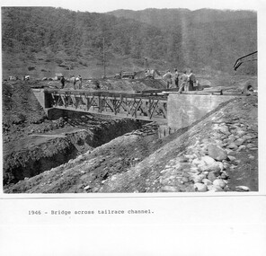
... 1-1946 – Bridge across tailrace channel Page number 9 2-New mess building, Mt Beauty 6.4.46 Page number 10 3- STATE ELECTRICITY COMMISSION OF VICTORIA Date: 10.1.47 Time: 11.40am No K2271 Kiewa Hydro Electric Works Homan’s Gap Saw Mill – Rip Saw Page number 11 4- STATE ELECTRICITY COMMISSION OF VICTORIA Date: 5.10.47 Time: 11am No K4111 Kiewa Hydro Electric Works Diamond Drilling Plant – Big Hill Page number 12 5- STATE ELECTRICITY COMMISSION OF VICTORIA Date: 11.2.48 Time: 3pm No K4277 Kiewa Hydro Electric Works Rocky Valley Camp-Mess Building Page number 13 6- STATE ELECTRICITY COMMISSION OF VICTORIA Date: 15.4.48 Time: 4.30pm No K4397 Kiewa Hydro Electric Works Parlimentary Party at Rocky Valley Page number 14 7- STATE ELECTRICITY COMMISSION OF VICTORIA Date: 22.8.48 Time: 9am No K4668 Kiewa Hydro Electric Works General view of No.4 Headrace Tunnel Page number 15 8-STATE ELECTRICITY COMMISSION OF VICTORIA Date: 5.9.49 Time: 10am No K5180 Kiewa Hydro Electric Works Allis-Chalmers Tractor School – HD 19, Mr I Crossthwaite at Controls Page number 16 9- No markings Page number 17 10- STATE ELECTRICITY COMMISSION OF VICTORIA Date: 7,12.49 Time: 4pm No K5423 Kiewa Hydro Electric Works No. 5 Raceline – Balasting Track with improvised truck. ...Mount Beauty, and to a lesser extent Bogong, are among these places. secv; kiewa hydro electric scheme; mt beauty; bogong; construction area 1-1946 – Bridge across tailrace channel Page number 9 2-New mess building, Mt Beauty 6.4.46 Page number 10 3- STATE ELECTRICITY COMMISSION OF VICTORIA Date: 10.1.47 Time: 11.40am No K2271 Kiewa Hydro Electric Works Homan’s Gap Saw Mill – Rip Saw Page number 11 4- STATE ELECTRICITY COMMISSION OF VICTORIA Date: 5.10.47 Time: 11am No K4111 Kiewa Hydro Electric Works Diamond Drilling Plant – Big Hill Page number 12 5- STATE ELECTRICITY COMMISSION OF VICTORIA Date: 11.2.48 Time: 3pm No K4277 Kiewa Hydro Electric Works Rocky Valley Camp-Mess Building Page number 13 6- STATE ELECTRICITY COMMISSION OF VICTORIA Date: 15.4.48 Time: 4.30pm No K4397 Kiewa Hydro Electric Works Parlimentary Party at Rocky Valley Page number 14 7- STATE ELECTRICITY COMMISSION OF VICTORIA Date: 22.8.48 Time: 9am No K4668 Kiewa Hydro Electric Works General view of No.4 Headrace Tunnel Page number 15 8-STATE ELECTRICITY COMMISSION OF VICTORIA Date: 5.9.49 Time: 10am No K5180 Kiewa Hydro Electric Works Allis-Chalmers Tractor School – HD 19, Mr I Crossthwaite at Controls Page number 16 9- No markings Page number 17 10- STATE ELECTRICITY COMMISSION OF VICTORIA Date: 7,12.49 Time: 4pm No K5423 Kiewa Hydro Electric Works No. 5 Raceline – Balasting Track with improvised truck. ...Although the Kiewa Hydro-Electric Scheme was first proposed in 1911, construction did not commence until 1938. As part of the push to cut electricity costs and diversify supply, the Victorian Government (circa 1930) initiated the conversion from primarily brown coal supply to hydro – electricity. Field investigations during the 1940’s resulted in a new proposal for a scheme that had more than double the capacity of the 1938 scheme. The Kiewa Hydroelectric Scheme became the largest scheme of its kind in the State Of Victoria and the second largest scheme in Australia. The number of personnel involved in the planning and construction of the scheme increased dramatically. During the late 1940’s, most activity centred around the construction of the West Kiewa Power Station, Rocky Valley Reservoir, McKay Creek Power Station and the Bogong Creek Aqueduct.A common thread across all the larger hydro scheme constructions was the need for workers, both qualified and unqualified who came from around the world seeking a new life for themselves and their families. New accommodation and facilities were required for the army of workers engaged in construction in often remote and wild areas. The SEC had a high demand for timber, and set up the first of a number of sawmills at Bogong Creek in 1939 and set up the first hardwood logging in the headwaters of the Kiewa River. These new ‘towns’ such as Mt Beauty and Bogong, survived, serving the needs of operational personnel and their families, and expanding with growth of new industries. Mount Beauty, and to a lesser extent Bogong, are among these places. PHYSICAL: Large A3 size spiral bound display folder containing 21 pages of photocopied black and white photographs of various aspects of the early days of the Kiewa Valley Hydro-electric scheme including equipment, various work sites and photographs of workers and their families. 1-Bridge across Tailrace Channel 1946 2-New Mess building, Mt Beauty 3-Homan’s Gap Saw Mill 4- Diamond Drilling Plant – Big Hill 5-Rocky Valley Camp-Mess Building 6-Parlimentary Party at Rocky Valley 7-No.4 Headrace Tunnel 8- Allis-Chalmers Tractor School 9- SECV Heavy Machinery lined up by road 10- No. 5 Raceline – Balasting Track with improvised truck 1-1946 – Bridge across tailrace channel Page number 9 2-New mess building, Mt Beauty 6.4.46 Page number 10 3- STATE ELECTRICITY COMMISSION OF VICTORIA Date: 10.1.47 Time: 11.40am No K2271 Kiewa Hydro Electric Works Homan’s Gap Saw Mill – Rip Saw Page number 11 4- STATE ELECTRICITY COMMISSION OF VICTORIA Date: 5.10.47 Time: 11am No K4111 Kiewa Hydro Electric Works Diamond Drilling Plant – Big Hill Page number 12 5- STATE ELECTRICITY COMMISSION OF VICTORIA Date: 11.2.48 Time: 3pm No K4277 Kiewa Hydro Electric Works Rocky Valley Camp-Mess Building Page number 13 6- STATE ELECTRICITY COMMISSION OF VICTORIA Date: 15.4.48 Time: 4.30pm No K4397 Kiewa Hydro Electric Works Parlimentary Party at Rocky Valley Page number 14 7- STATE ELECTRICITY COMMISSION OF VICTORIA Date: 22.8.48 Time: 9am No K4668 Kiewa Hydro Electric Works General view of No.4 Headrace Tunnel Page number 15 8-STATE ELECTRICITY COMMISSION OF VICTORIA Date: 5.9.49 Time: 10am No K5180 Kiewa Hydro Electric Works Allis-Chalmers Tractor School – HD 19, Mr I Crossthwaite at Controls Page number 16 9- No markings Page number 17 10- STATE ELECTRICITY COMMISSION OF VICTORIA Date: 7,12.49 Time: 4pm No K5423 Kiewa Hydro Electric Works No. 5 Raceline – Balasting Track with improvised truck. Page number 18 secv; kiewa hydro electric scheme; mt beauty; bogong; construction area -
 Kiewa Valley Historical Society
Photograph - Folder of Photographs – Photocopied set of 10 black and white photographs (pages 19 - 28) from the display folder put together by KVHS to document life on the Kiewa Valley Hydro-electric Scheme
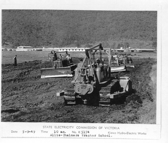
... Tunnel? Page number 27 10-STATE ELECTRICITY COMMISSION OF VICTORIA Date: Jan 1953 Time: No K7307 Kiewa Hydro Electric Works CLOVER DAM Page number 28 ...Mount Beauty, and to a lesser extent Bogong, are among these places. secv; kiewa hydro electric scheme; bogong; mt beauty; construction area 1-STATE ELECTRICITY COMMISSION OF VICTORIA Date: 5.9.49 Time: 10amm No K5174 Kiewa Hydro Electric Works Allis Chalmers Tractor School Page number 19 2-STATE ELECTRICITY COMMISSION OF VICTORIA Date: 22.2.50 Time: 3.30pm No K5601 Kiewa Hydro Electric Works Gardens outside Administrative Office – Mt Beauty Page number 20 3-Mt Beauty house – 1950 Page number 21 4-STATE ELECTRICITY COMMISSION OF VICTORIA Date: 23.10.50 Time: 11.15am No K6331 Kiewa Hydro Electric Works Bogong-Bridge over Pretty Valley River Page number 22 5-STATE ELECTRICITY COMMISSION OF VICTORIA Date: 23.6.50 Time: 2.30pm No K5844 Kiewa Hydro Electric Works ROCKY VALLEY SPILLWAY TUNNEL BREAK THROUGH Page number 23 6-20/3/52 – No. 1 Headrace Tunnel Drilling face (E.E.E. contract) Page number 24 7-6/6/52 – No 4 Power Station – Drilling Page number 25 8-STATE ELECTRICITY COMMISSION OF VICTORIA Date: 6/6/52 Time: No K7113 Kiewa Hydro Electric Works Clover Dam Flood Waters Page number 26 9-STATE ELECTRICITY COMMISSION OF VICTORIA Date: Oct 1952 Time: No K7239 Kiewa Hydro Electric Works No. 1 HEAD RACE TUNNEL PORTAL BUILDING. ...Although the Kiewa Hydro-Electric Scheme was first proposed in 1911, construction did not commence until 1938. As part of the push to cut electricity costs and diversify supply, the Victorian Government (circa 1930) initiated the conversion from primarily brown coal supply to hydro – electricity. Field investigations during the 1940’s resulted in a new proposal for a scheme that had more than double the capacity of the 1938 scheme. The Kiewa Hydroelectric Scheme became the largest scheme of its kind in the State Of Victoria and the second largest scheme in Australia. The number of personnel involved in the planning and construction of the scheme increased dramatically. During the late 1940’s, most activity centred around the construction of the West Kiewa Power Station, Rocky Valley Reservoir, McKay Creek Power Station and the Bogong Creek Aqueduct.A common thread across all the larger hydro scheme constructions was the need for workers, both qualified and unqualified who came from around the world seeking a new life for themselves and their families. New accommodation and facilities were required for the army of workers engaged in construction in often remote and wild areas. The SEC had a high demand for timber, and set up the first of a number of sawmills at Bogong Creek in 1939 and set up the first hardwood logging in the headwaters of the Kiewa River. These new ‘towns’ such as Mt Beauty and Bogong, survived, serving the needs of operational personnel and their families, and expanding with growth of new industries. Mount Beauty, and to a lesser extent Bogong, are among these places. Large A3 size spiral bound display folder containing 21 pages of photocopied black and white photographs of various aspects of the early days of the Kiewa Valley Hydro-electric scheme including equipment, various work sites and photographs of workers and their families. 1-Allis Chalmers Tractor School 2- Gardens outside Administrative Office – Mt Beauty 3- Mt Beauty house – 1950 4-Bridge over Pretty Valley River, Bogong 5-Rocky Valley Spillway Tunnel break through 6-Ni 1 Headrace Tunnel drilling face 7-No 4 Power Station Drilling 8-Clover Dam Flood Waters 9-No1 Head Race Tunnel Portal Building 10-Clover Dam 1-STATE ELECTRICITY COMMISSION OF VICTORIA Date: 5.9.49 Time: 10amm No K5174 Kiewa Hydro Electric Works Allis Chalmers Tractor School Page number 19 2-STATE ELECTRICITY COMMISSION OF VICTORIA Date: 22.2.50 Time: 3.30pm No K5601 Kiewa Hydro Electric Works Gardens outside Administrative Office – Mt Beauty Page number 20 3-Mt Beauty house – 1950 Page number 21 4-STATE ELECTRICITY COMMISSION OF VICTORIA Date: 23.10.50 Time: 11.15am No K6331 Kiewa Hydro Electric Works Bogong-Bridge over Pretty Valley River Page number 22 5-STATE ELECTRICITY COMMISSION OF VICTORIA Date: 23.6.50 Time: 2.30pm No K5844 Kiewa Hydro Electric Works ROCKY VALLEY SPILLWAY TUNNEL BREAK THROUGH Page number 23 6-20/3/52 – No. 1 Headrace Tunnel Drilling face (E.E.E. contract) Page number 24 7-6/6/52 – No 4 Power Station – Drilling Page number 25 8-STATE ELECTRICITY COMMISSION OF VICTORIA Date: 6/6/52 Time: No K7113 Kiewa Hydro Electric Works Clover Dam Flood Waters Page number 26 9-STATE ELECTRICITY COMMISSION OF VICTORIA Date: Oct 1952 Time: No K7239 Kiewa Hydro Electric Works No. 1 HEAD RACE TUNNEL PORTAL BUILDING. Handwritten underneath – This information from Ron White-the later Principal Hydro Engineer of the SEC. Oct 1952 Location incorrect? All work on No 1 had ceased after financial crash of 1951. This photo would refer to No 4 Headrace Tunnel? Page number 27 10-STATE ELECTRICITY COMMISSION OF VICTORIA Date: Jan 1953 Time: No K7307 Kiewa Hydro Electric Works CLOVER DAM Page number 28 secv; kiewa hydro electric scheme; bogong; mt beauty; construction area -
 Kiewa Valley Historical Society
Photograph - Folder of Photographs – Photocopied set of 10 black and white photographs (pages 29 - 38) from the display folder put together by KVHS to document life on the Kiewa Valley Hydro-electric Scheme
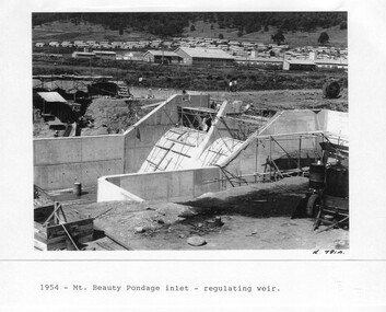
... 1-1954 – Mt Beauty Pondage inlet – Regulating weir Page number 29 2-28/10/54 – Langfords Gap Basalt Hill – Tunnel in quarry face K7860 Page number 30 3-STATE ELECTRICITY COMMISSION OF VICTORIA Date: 17.8.55 Time: No K8132 Kiewa Hydro Electric Works ROCKY VALLEY CAMP – FROM ENGINEERING OFFICE Page number 31 4-28/10/54 – Basalt Hill tunnel portal K7859 Page number 32 5-No.1 Pressure Shaft Works Bench 5.7.56 Page number 33 6- No. 1 Power Station 26.4.59 Page number 34 7- No markings Page number 35 8-No markings (Wooden board on ground printed with - POLAR A.N.GELATINE DYNAMITE “75” DE 28.8.40) Page number 36 9-No markings Page number 37 10-Howman’s Gap campsite at 4,150 feet Page number 38 ...Mount Beauty, and to a lesser extent Bogong, are among these places. secv; kiewa hydro electric scheme; mt beauty; bogong; construction area 1-1954 – Mt Beauty Pondage inlet – Regulating weir Page number 29 2-28/10/54 – Langfords Gap Basalt Hill – Tunnel in quarry face K7860 Page number 30 3-STATE ELECTRICITY COMMISSION OF VICTORIA Date: 17.8.55 Time: No K8132 Kiewa Hydro Electric Works ROCKY VALLEY CAMP – FROM ENGINEERING OFFICE Page number 31 4-28/10/54 – Basalt Hill tunnel portal K7859 Page number 32 5-No.1 Pressure Shaft Works Bench 5.7.56 Page number 33 6- No. 1 Power Station 26.4.59 Page number 34 7- No markings Page number 35 8-No markings (Wooden board on ground printed with - POLAR A.N.GELATINE DYNAMITE “75” DE 28.8.40) Page number 36 9-No markings Page number 37 10-Howman’s Gap campsite at 4,150 feet Page number 38 Large A3 size spiral bound display folder containing 21 pages of photocopied black and white photographs of various aspects of the early days of the Kiewa Valley Hydro-electric scheme including equipment, various work sites and photographs of workers and their families. 1-Mt Beauty Pondage inlet-Regulating weir 2-Langfords Gap Basalt Hill-Tunnel in quarry face.3-Rocky Valley Camp-from Engineering Office 4-Basalt Hill tunnel portal 5-No 1 Pressure Shaft Works Bench 6-No 1 Power Station 7-Overturned haulage wagons on the side of an embankment 8- Group of workers dressed in wet weather gear inside a tunnel 9-Workmen and vehicle in tunnel 10-Howman’s Gap campsite at 4,150 feet Photograph Folder of Photographs – Photocopied set of 10 black and white photographs (pages 29 - 38) from the display folder put together by KVHS to document life on the Kiewa Valley Hydro-electric Scheme ...Although the Kiewa Hydro-Electric Scheme was first proposed in 1911, construction did not commence until 1938. As part of the push to cut electricity costs and diversify supply, the Victorian Government (circa 1930) initiated the conversion from primarily brown coal supply to hydro – electricity. Field investigations during the 1940’s resulted in a new proposal for a scheme that had more than double the capacity of the 1938 scheme. The Kiewa Hydroelectric Scheme became the largest scheme of its kind in the State Of Victoria and the second largest scheme in Australia. The number of personnel involved in the planning and construction of the scheme increased dramatically. During the late 1940’s, most activity centred around the construction of the West Kiewa Power Station, Rocky Valley Reservoir, McKay Creek Power Station and the Bogong Creek Aqueduct.A common thread across all the larger hydro scheme constructions was the need for workers, both qualified and unqualified who came from around the world seeking a new life for themselves and their families. New accommodation and facilities were required for the army of workers engaged in construction in often remote and wild areas. The SEC had a high demand for timber, and set up the first of a number of sawmills at Bogong Creek in 1939 and set up the first hardwood logging in the headwaters of the Kiewa River. These new ‘towns’ such as Mt Beauty and Bogong, survived, serving the needs of operational personnel and their families, and expanding with growth of new industries. Mount Beauty, and to a lesser extent Bogong, are among these places. Large A3 size spiral bound display folder containing 21 pages of photocopied black and white photographs of various aspects of the early days of the Kiewa Valley Hydro-electric scheme including equipment, various work sites and photographs of workers and their families. 1-Mt Beauty Pondage inlet-Regulating weir 2-Langfords Gap Basalt Hill-Tunnel in quarry face.3-Rocky Valley Camp-from Engineering Office 4-Basalt Hill tunnel portal 5-No 1 Pressure Shaft Works Bench 6-No 1 Power Station 7-Overturned haulage wagons on the side of an embankment 8- Group of workers dressed in wet weather gear inside a tunnel 9-Workmen and vehicle in tunnel 10-Howman’s Gap campsite at 4,150 feet 1-1954 – Mt Beauty Pondage inlet – Regulating weir Page number 29 2-28/10/54 – Langfords Gap Basalt Hill – Tunnel in quarry face K7860 Page number 30 3-STATE ELECTRICITY COMMISSION OF VICTORIA Date: 17.8.55 Time: No K8132 Kiewa Hydro Electric Works ROCKY VALLEY CAMP – FROM ENGINEERING OFFICE Page number 31 4-28/10/54 – Basalt Hill tunnel portal K7859 Page number 32 5-No.1 Pressure Shaft Works Bench 5.7.56 Page number 33 6- No. 1 Power Station 26.4.59 Page number 34 7- No markings Page number 35 8-No markings (Wooden board on ground printed with - POLAR A.N.GELATINE DYNAMITE “75” DE 28.8.40) Page number 36 9-No markings Page number 37 10-Howman’s Gap campsite at 4,150 feet Page number 38 secv; kiewa hydro electric scheme; mt beauty; bogong; construction area -
 Kiewa Valley Historical Society
Photograph - Folder of Photographs – Photocopied set of black and white photographs (pages 49 -58) from the display folder put together by KVHS to document life on the Kiewa Valley Hydro-electric Scheme
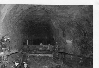
... Time:.. No K7860 Kiewa Hydro Electric Works LANGFORD GAP BASALT HILL TUNNEL FACE Page number 49 10-(a) No markings 11- STATE ELECTRICITY COMMISSION OF VICTORIA Date: 20.3.52 Time: No K6979 Kiewa Hydro Electric Works No. 1 HEAD RACE TUNNEL – DRILLING FACE (E.E.E. ...Time:.. No K7860 Kiewa Hydro Electric Works LANGFORD GAP BASALT HILL TUNNEL FACE Page number 49 10-(a) No markings 11- STATE ELECTRICITY COMMISSION OF VICTORIA Date: 20.3.52 Time: No K6979 Kiewa Hydro Electric Works No. 1 HEAD RACE TUNNEL – DRILLING FACE (E.E.E. ...Although the Kiewa Hydro-Electric Scheme was first proposed in 1911, construction did not commence until 1938. As part of the push to cut electricity costs and diversify supply, the Victorian Government (circa 1930) initiated the conversion from primarily brown coal supply to hydro – electricity. Field investigations during the 1940’s resulted in a new proposal for a scheme that had more than double the capacity of the 1938 scheme. The Kiewa Hydroelectric Scheme became the largest scheme of its kind in the State Of Victoria and the second largest scheme in Australia. The number of personnel involved in the planning and construction of the scheme increased dramatically. During the late 1940’s, most activity centred around the construction of the West Kiewa Power Station, Rocky Valley Reservoir, McKay Creek Power Station and the Bogong Creek Aqueduct.A common thread across all the larger hydro scheme constructions was the need for workers, both qualified and unqualified who came from around the world seeking a new life for themselves and their families. New accommodation and facilities were required for the army of workers engaged in construction in often remote and wild areas. The SEC had a high demand for timber, and set up the first of a number of sawmills at Bogong Creek in 1939 and set up the first hardwood logging in the headwaters of the Kiewa River. These new ‘towns’ such as Mt Beauty and Bogong, survived, serving the needs of operational personnel and their families, and expanding with growth of new industries. Mount Beauty, and to a lesser extent Bogong, are among these places. Large A3 size spiral bound display folder containing photocopied black and white photographs of various aspects of the early days of the Kiewa Valley Hydro-electric scheme including equipment, various work sites and photographs of workers and their families. 1-Workmen working inside one of the tunnels. 2-Workman drilling in West Kiewa Tunnel 3-Junction Dam wall construction 4&5-2B&W photographs Kiewa House residents ready to go to a ball in Mt Beauty 6-Workmen warming up in front of a fire at No 1 bench 7-Workmen being hauled in at No 4 P.S Shaft 8-No 4 Power Station – Drilling 9-Workmen eating a hot meal in the tunnel. 10-2 photographs (a)Pretty Valley camp showing workman’s huts and construction materials & (b)Worker in Langford Gap Basalt Hill Tunnel face 11-Tunnel entrance (unlabelled) with rail tracks in foreground 12- Workmen drilling at No 1 Head race tunnel-Drilling face 13- No 1 Power Station 14-Workmen at the entrance to one of the SECV tunnels under construction 1-SECV number at bottom of picture Half obscured possibly K8461 Page number 53 2-In West Kiewa Tunnel Page number 54 3- Construction of Junction Dam wall – approximately 1941 Page number 55 4&5- Residents of Kiewa House at Bogong ready to go to the ball at Mt Beauty-1946. Handwritten on a copy of the photo on opposite page Mrs Lorna Crosset filled out the names *Dad was Des Crossett – his daughter is Gael Petcopoulis Greta engaged to John broke it off. Charlie, Rosalind, Bill, Priscilla, Max Lawrence-Dad’s Boss, Mary & Max married, Mary, Kay, Gwen McPherson Mum’s boss, John McCluskey (c) At No. 5 Bench Page number 56 6- STATE ELECTRICITY COMMISSION OF VICTORIA Date: 27.2.51 Time:2.15pm No K6373 Kiewa Hydro Electric Works No. 4 P.S. Shaft – Haulage of men in buckets (b) As above Handwritten at top of photo Appendix 4 page number 57 7- STATE ELECTRICITY COMMISSION OF VICTORIA Date: 6.6.52 Time:… No K7122 Kiewa Hydro Electric Works No. 4 POWER STATION – DRILLING page number 58 8-No markings page number 59 9-(a)Handwritten under photograph Approx. 1948/49 (b) STATE ELECTRICITY COMMISSION OF VICTORIA Date: 28.10.54 Time:.. No K7860 Kiewa Hydro Electric Works LANGFORD GAP BASALT HILL TUNNEL FACE Page number 49 10-(a) No markings 11- STATE ELECTRICITY COMMISSION OF VICTORIA Date: 20.3.52 Time: No K6979 Kiewa Hydro Electric Works No. 1 HEAD RACE TUNNEL – DRILLING FACE (E.E.E. CONTRACT) ‘The Frenchies’ (E.E.E) as they were affectionately known Page number 50 12-31.5.56 No. 1 Power Station Aggregate Stock Piles. Page number 51 13&14-No markings Page number 52 secv; kiewa hydro electric scheme; bogong; mt beauty; construction area -
 Kiewa Valley Historical Society
Photos: SECV Construction
... time. These photos were displayed on the walls of the hotel when the building was the SEC Workmans Club KHES Construction of KHES x12 Most of them framed. Large black and white photos of construction of the Kiewa Hydro Electric Scheme: 1. Clover Dam Construction 2. Clover Dam Construction suspended on a crane 3. Power Station Clover Dam 4. Hauling tunnel ...The SECV constructed the Kiewa Hydro Electric Scheme from the late 1940s to the early 1960s. Dams, Power Stations, towns, etc. were built during this timeThese photos show a lot of detail of the work involved in constructing large structures eg. power stations, dams etc. Also they give an insight into safety eg. clothing etc. at the time. These photos were displayed on the walls of the hotel when the building was the SEC Workmans Club x12 Most of them framed. Large black and white photos of construction of the Kiewa Hydro Electric Scheme: 1. Clover Dam Construction 2. Clover Dam Construction suspended on a crane 3. Power Station Clover Dam 4. Hauling tunnel muck. Tunnel "Ruston" locomotive on rail entrance.5. McKay Power Station 6. Connecting the headrace pipe to turbo turbines - large pipes and workman (double pipe) bifurcate pipes. 7. Installing a generator - seven workmen with hard hats (assembling). 8. V3536 number plate - fire fighting truck - filling up with water. 9. 1939 after bushfire. 10. West Kiewa Power Station - labelled. 11. Lining the portal of a tunnel 12. Camp and offices on left, tunnel entrance on right.khes, construction of khes -
 Kiewa Valley Historical Society
A) Document - The Field Welding of No. 1 Pipeline - Kiewa. B) Book - SECV, Kiewa Hydro Electric Works, Foreman's Guide, A) by J. M. Scott, Welding Inspector B) by State Electricity Commission of Victoria
... It was built on the mountain rather than as a tunnel inside the mountain - "It was argued that a pressure pipeline on the surface, while not actually cheaper than the tunnel could possibly save one year in construction time.'...It was built on the mountain rather than as a tunnel inside the mountain - "It was argued that a pressure pipeline on the surface, while not actually cheaper than the tunnel could possibly save one year in construction time.' The document is a report on the welding involved on the No. 1 pipeline. ...No. 1 Pipeline heads down the mountain from McKay Power Station (the Kiewa Hydro Electric Scheme) and can be seen from the Falls Creek Rd.. The pipeline is 1635m long. It was built on the mountain rather than as a tunnel inside the mountain - "It was argued that a pressure pipeline on the surface, while not actually cheaper than the tunnel could possibly save one year in construction time.'The document is a report on the welding involved on the No. 1 pipeline. J. M. Scott was the welding inspector for the SECV on the Kiewa Hydro Electric Scheme. The book is produced by the SECV and is the 'Foremen's Guide' and includes rules and regulations across all areas.A) 10 pages of a 'field record' all pages typed on one side. Stapled on top left corner B) Small, fat book c190 pages plus appendix. Thick and 'tattered looking'. Bound by flexible 'cloth?'(linen?) and fastened with 2 rusty fasteners.B) Cover - F/M J. Scott and red SEC stamp. Inside cover: "checked ... 22-8-55" and "checked 18-11-55"j.m. scott welding inspector, no 1 pipeline mckay power station, kiewa hydro electric scheme -
 Bendigo Military Museum
Photograph - PHOTOGRAPHS WW1, C.1915
... Tunneling Coy. This was at "Black Watch Sap Hill 70". The Germans were laying underground mines at the same time as the Australians. ...Tunneling Coy. This was at "Black Watch Sap Hill 70". The Germans were laying underground mines at the same time as the Australians. ....1) & .2) Albert Edward LADD (Bendigo) No. 1071, enlisted in the AIF on 1.8.15 in Mining Corps Coy 3, aged 29 years and 6 months. Embarked for England 20.2.1916. KIA 27.1.1916 while serving with the 3rd Aust. Tunneling Coy. This was at "Black Watch Sap Hill 70". The Germans were laying underground mines at the same time as the Australians. The Germans blew their mines at 12.40am, this combined with the Australian ammonal mines made a massive explosion killing over 20 Australians. Crumps & Camouflets by Damien Finlayson describes this in his book on pages 151-153. .3) In the photo are from left, Julia Ann Ladd, Rita Mary Ladd, Florence May Ladd and Albert Edward Ladd. Prewar, Albert worked at the "Coleman & Tachees Mine" in California Gully..1) & .2) Photos, sepia tone, portrait of a soldier in peak hat wearing a tie, oval shape with surround. .3) Photo, sepia tone, women with two children and soldier, one child on a setting, one on soldiers knee..1) & .2) Inset on front: "12.07.11-18.04.15" .3) Inset in front: "12.07.11-18.04.56photographs, 3rd, hill 70, kia -
 Port of Echuca
Colour photograph, 1979
... tunnel to the laneway was built , so the drinkers could escape the Police raids. For many years it was a private dwelling, or an office. In 1973 the City of Echuca bought the Star Hotel and resored it. At the time...tunnel to the laneway was built , so the drinkers could escape the Police raids. For many years it was a private dwelling, or an office. In 1973 the City of Echuca bought the Star Hotel and resored it. At the time ...The Star Hotel was built in 1863 as a private dwelling, by James Shackell who owned the Bond Store, next door. It was a small house consisting of only a couple of rooms. In 1867 Joseph Salomon bought the house and converted it into a hotel. He built an underground bar to "deal with the peculiarities of the Echuca climate". It was called 'The Shades'. In 1890 Jane Pygall bought the hotel, which was described by the Riverine Herald as having ' three parlours, seven bedrooms, underground bar, kitchen, bathroom, outhouses, small stables, and entrance from two streets." She changed the name to The Esplanade Hotel. In 1890 it was de-licensed along with many hotels in Echuca. It had been a very popular drinking place for all the wharf workers, who continued to to drink illegally in the underground bar. It was then that the escape tunnel to the laneway was built , so the drinkers could escape the Police raids. For many years it was a private dwelling, or an office. In 1973 the City of Echuca bought the Star Hotel and resored it. At the time this photograph was taken it was the main tourist information centre for the Port of Echuca. It now operates as a hotel, serving meals and providing performance opportunities for musicians.The Star Hotel is very significant in Echuca's history due to its proximity to the Echuca Wharf. It was the closest bar to the wharf. Despite Jane Pygall trying to improve the quality of her clientele, the wharf drinkers preferred to drink at The Star Hotel, as the Bridge Hotel catered for more upmarket clientele. After de-licensing in 1897, the workers continued to drink at The Shades Bar and even put in place elaborate strategies to enable them to drink illegally there. It is now a large eating and entertainment site, and the public are still able to visit 'The Shades Bar'.A coloured photograph of the Star Hotel building in Murray Esplanade. The photograph is taken from the east side of the street. The Shackell's Bond Store can be seen on the left of the photograph. Printed on the back are the words, "This paper manufactured by Kodak". Also on the back is green Port of Echuca stamp. Written across the front of the Bond Store are the words 'World In Wax Museum.' On a sign outside the Star Hotel are the words, "Port Information Centre. Ticket Sales. Souvenirs . Star Hotel 1867."port of echuca, star hotel, shackell, james, salomon, joseph, pygall, jane, esplanade hotel, 1863, underground bar, the shades, de-licensing of echuca hotels -
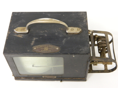 Kiewa Valley Historical Society
Barometer Anoroid, circa mid to late 1900's
... tunneling could commence. This barometer is very relevant to the Kiewa Valley history because it presents the high degree of professional and technical information required at the time before implementing the "Scheme" upon the virgin alpine region and its effects upon the "natural" flows of the rivers within the Kiewa Valley. ...This barometer was part the hydrology and forestry groups working within the SEC Vic Hydro Scheme from the initial appraisal review long before any construction began in the 1940's. The river flows and rainfall patterns had to be established before any construction of holding dams or tunneling could commence. This barometer is very relevant to the Kiewa Valley history because it presents the high degree of professional and technical information required at the time before implementing the "Scheme" upon the virgin alpine region and its effects upon the "natural" flows of the rivers within the Kiewa Valley. Time since the start of the project has verified the use of instruments such as this barometer and the information gained from its use that the success of any large impact upon a sensitive environment requires a thorough and systematic study before implementation. Weather records were kept of temperature, wet-bulb temperature, wind direction, speed and barometric pressures. To record barometric pressure a meter was devised with a clockwork mechanism which took one week to do a revolution. A chart was fitted to a drum and had an ink pen shaped like a little shovel. The shovel was filled with ink and was checked daily. To calibrate the barometer it was sent to the Melbourne General Post Office to be compared against the one there (at sea level). After calibration it was sent back to the Bogong Camp.On plaque on top side."NEGRETTI & ZAMBRA" underneath this and in smaller print "TRADE MARK" below this "LONDON" On the bottom and in small print "HOBART DUFFPty Ltd COLLINS HOUSE MELBOURNE C1"kiewa hydro electricity scheme, victorian state electricity commission, transformers, resistors, barometers -
 Bendigo Military Museum
Award - MEDAL SETS WW1, WW2, 1) Post 1919, 1945, .2) Post 1919
... time he was a Sgt in 4 Garrison Batt. A Miner, Alexander John Sundin (born Bendigo, enlisted Bendigo) No 7914 enlisted on 24.7.1917 in 3rd Aust Tunneling Coy age 44 years 8 months. ...time he was a Sgt in 4 Garrison Batt. A Miner, Alexander John Sundin (born Bendigo, enlisted Bendigo) No 7914 enlisted on 24.7.1917 in 3rd Aust Tunneling Coy age 44 years 8 months. ...John Preece (born Wotseley, enlisted Keswick SA) No 765 enlisted in the AIF on 7.9.1914 in F Coy 12th Batt age 26 years 7 months. Embarked for Eygpt 20.10.1914, embarked for Gallipoli 2.3.1915. Embarked for France 2.4.1916, hospital 4.7.1916 with Fracture of the right hand accident, hospital 9.6.1918 with Influenza, discharged from the AIF 31.1.1919. Enlisted WW11 as No S393 on 12.8.1940, hospital 10.7.1941 with Gastro Enteritis, 23.4.1942 injury to right knee, 27.12.1942 with Pluerisy, 28.5.1943 with Nueritis, discharged from the Army medically unfit 6.9.1943. At the time he was a Sgt in 4 Garrison Batt. A Miner, Alexander John Sundin (born Bendigo, enlisted Bendigo) No 7914 enlisted on 24.7.1917 in 3rd Aust Tunneling Coy age 44 years 8 months. Embarked 21.11.1917, Gassed 10.9.1918, discharged medically unfit 30.1.1919.1.) Medal set, court mounted, set of (5) re J Preece. 1. 1914-15 Star. 2. War Medal 1914-18 3. Victory Medal 1914 - 1919 4. War Medal 1939-45. 5. Australian Service Medal. .2) medal set, court mounted, set of (2) re A.J.Sundin. 1. War Medal 1914-19. 2. Victory Medal..1) "765 DVR J Preece 12 BN AIF. - "S393 J Preece" .2) "7914 SPR A.J.Sundin 3 Tun Coy A.I.F"medals, military, history -
Federation University Historical Collection
Article - Article - Women, Ballarat School of MInes: Women of Note; Bella Guerin, Educator and Activist, (1858 - 1923)
... In recognition of her time at Ballarat School of Mines, a Hall of Residence at Federation University, Mount Helen Campus has been named after her, Bella Guerin Hall of Residence. Tunnelling...In recognition of her time at Ballarat School of Mines, a Hall of Residence at Federation University, Mount Helen Campus has been named after her, Bella Guerin Hall of Residence. Tunnelling ...Julia Margaret (Bella) Guerin (1858-1923), feminist, political activist and teacher, was born on 23 April 1858. Her father was a Governor of Gaols and was so at Ballarat Gaol from 1860s to 1890.- Having studied at home to pass matriculation in 1878, Bella entered Melbourne University in 1881, the same year her brother Marco began at Ballarat School of Mines to study Metallurgy and Assaying. Bella became the first woman to graduate from an Australian University when she gained her B.A. from the University of Melbourne in December 1883, becoming M.A. upon application in 1885. She taught first at Loreto Convent, Ballarat, urging higher education scholarships for Catholic girls to produce 'a band of noble thoughtful women as a powerful influence for good'; then as Lady Principal of Ballarat School of Mines University classes from 1887-1890, resigning upon marriage. Returning to teaching from financial necessity she began to frequent suffragist circles from the mid 1890s. She also became very involved within the Labor Party. She wrote speeches for Vida Golstein, a campaigner for women's rights, the right to vote and stand for elections. In recognition of her time at Ballarat School of Mines, a Hall of Residence at Federation University, Mount Helen Campus has been named after her, Bella Guerin Hall of Residence. Tunnelling tradition dictates a Tunnel Boring Machine (TBM) cannot start work until it has been given a female name, a sign of good luck for the project ahead. This dates back to the 1500s when miners and military engineers working with explosives for underground excavation, prayed to Saint Barbara for protection.The TBMs working on the two West Gate extensions are named after two very prominent women working for the rights for women. They are named Bella (Bella Guerin) and Vida (Vida Goldstein)women of note, feminist, political activist, teacher, melbourne university, first female university graduate, loreto convent ballarat, lady principal of ballarat school of mines, 1887-1890, labor party, hall of residence, bella guerin hall of residence, federation university, mount helen campus, julia margaret guerin, bella guerin, governor of gaols, ballarat gaol, father, marco guerin, brother, ballarat school of mines, metallurgy, assaying, women's rights, vote for women, vida goldstein, west gate tunnels, tunnel boring machines, tbms, bella, vida -
 Eltham District Historical Society Inc
Photograph - Digital Photograph, Alan King, Golden King Mine poppet-head, Yarrambat Primary School, 1 February 2008
... It was a wild time and bushrangers - and later gangster Squizzy Taylor - were said to hide4 in the old Pioneer Tunnel in Dunne’s Gully between Heard Avenue and Pioneer Road. ...It was a wild time and bushrangers - and later gangster Squizzy Taylor - were said to hide4 in the old Pioneer Tunnel in Dunne’s Gully between Heard Avenue and Pioneer Road. ...The Golden King Mine poppet-head stands at the school’s Yan Yean Road exit gate. Published: Nillumbik Now and Then / Marguerite Marshall 2008; photographs Alan King with Marguerite Marshall.; p23 Early Yarambat - Tanck's Corner Its early settlers, who in the 1840s were amongst the first non-Aboriginal people in the area, found life tough as they grazed their sheep and cattle. Yarrambat was then known as Tanck’s Corner or Reynolds Corner, after wood carter, Frederick Tanck, who owned land north of Ironbark Road, at the corner of Yan Yean Road, and Thomas Reynolds, owner of the opposite property. After Reynolds sold his land, the corner became known as Tanck’s Corner. In 1929 the district’s name was changed to Yarrambat, believed to mean ‘high hill’ in the Wurundjeri language. Tanck’s Corner was in the centre of gold-bearing country and the district is honeycombed with old tunnels and shafts. However although gold played a dominant role for decades, there was insufficient to develop a substantial township. Meat and agricultural produce made a greater impact. Until the mid-20th century the only substantial building was the primary school. The first gold rush occurred around 1860, the second after 1900; then during the Depression, the Government paid men to pan for gold. The first rush attracted hundreds of Chinese people to Smugglers Gully, who constructed round diggings to keep away spirits. Alluvial miners lived along the Plenty River in tents or humpies - some fenced with gardens - and some miners distilled their own ‘plonk’. It was a wild time and bushrangers - and later gangster Squizzy Taylor - were said to hide4 in the old Pioneer Tunnel in Dunne’s Gully between Heard Avenue and Pioneer Road. Mines opposite Tanck’s Corner included Beer’s Line, Golden Crown and Golden Stairs. Some of the big mines had batteries and stampers to process quartz. At first there was plenty of alluvial gold, as much as two ounces to the ton. At times gold was exposed after heavy rains so fossickers panned for gold around orchard irrigation trenches. Gold was mined until 1984 when Yarrambat’s last operating goldmine, the Golden King Mine, in North Oatlands Road, closed. The Clayton family operated it full-time, making a comfortable living and in the 1960s it was the only private family gold mine in Victoria.5 Gold was such an important part of Yarrambat’s history that a gold poppet-head is the Yarrambat Primary School’s logo. The Golden King Mine poppet-head stands at the school’s Yan Yean Road exit gate. However this school was built in 1988. The original school No 2054, at the corner of Ironbark and Yan Yean Roads, was opened in 1878 and modified to its present form in the 1920s. In 2000 it was relocated to the Heritage Museum at Yarrambat Park.7 The school, whose first head teacher was Charles Planner, consisted of one room with a three-roomed residence. The school was also the community centre. On Saturday nights it was crammed for dances or euchre parties, community singing or other social events. On Sundays, services for different denominations took turns each week. However the school had its teething problems. Parents accused Charles Planner of neglecting his duties and the school closed several times. When it closed in 1892, only church services continued. Social activities moved elsewhere, such as the tennis club to the Stuchbery tennis court opposite. A sports day and woodchop on Boxing Day around 1900 was held at the Evelyn Hill Hotel, also called Evelyn Arms and Tunnel Hill Hotel, on the Greensborough–Diamond Creek Road. An annual agricultural show in Diamond Creek paraded through the town, and New Year’s Day picnics at the Yan Yean Reservoir included highland dancing and competitions. Also popular were the Indian hawkers who visited every three months, selling trinkets, clothing and other items. One called Jimmy ‘Allem dem Bedi’, gave presents and told stories, played draughts and sold delicious curries he cooked over his camp fire at night.This collection of almost 130 photos about places and people within the Shire of Nillumbik, an urban and rural municipality in Melbourne's north, contributes to an understanding of the history of the Shire. Published in 2008 immediately prior to the Black Saturday bushfires of February 7, 2009, it documents sites that were impacted, and in some cases destroyed by the fires. It includes photographs taken especially for the publication, creating a unique time capsule representing the Shire in the early 21st century. It remains the most recent comprehenesive publication devoted to the Shire's history connecting local residents to the past. nillumbik now and then (marshall-king) collection, golden king mine, tanck's corner, yarrambat primary school -
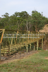
 Eltham District Historical Society Inc
Photograph - Digital Photograph, Marguerite Marshall, Diamond Valley Railway, Eltham Lower Park, 7 September 2008
... time to what little boys dream of – playing with trains. Passengers are instructed in safe behaviour, then the station master waves a white flag and off we go. The guard sits at the back with his whistle and green flag at the ready. The winding track, fringed by native trees and bushes planted by volunteers, stands on crown land managed by Nillumbik Council. The train clatters along the track and crosses a bridge over a drain elevated by name to The Blow Fly Creek. We pass by Meadmore Junction at a speed of three kilometres an hour. Then on through a tunnel...time to what little boys dream of – playing with trains. Passengers are instructed in safe behaviour, then the station master waves a white flag and off we go. The guard sits at the back with his whistle and green flag at the ready. The winding track, fringed by native trees and bushes planted by volunteers, stands on crown land managed by Nillumbik Council. The train clatters along the track and crosses a bridge over a drain elevated by name to The Blow Fly Creek. We pass by Meadmore Junction at a speed of three kilometres an hour. Then on through a tunnel ...Kids of all ages enjoy the Miniature Railway. Published: Nillumbik Now and Then / Marguerite Marshall 2008; photographs Alan King with Marguerite Marshall.; p163 On Sundays in Eltham thousands of children, mums, dads and grandparents can be seen travelling around Lower Eltham Park in tiny trains. They are among the two and half million passengers who have travelled on the Diamond Valley Railway since it officially began in 1961. The miniature railway originally operated from the 1940s at Chelsworth Park, Ivanhoe, until flooding caused it to be moved to the Eltham Lower Park in 1959. The railway is modelled on the 1920s era – the heyday of passenger rail travel – and the trains are built on a scale of two inches to the foot (1/6). Although not exact replicas, trains include models of the Spirit of Progress, Puffing Billy, The Overland, Dog Boxes, Vic Rail S class, G class and a NSW 81 Class. The three and a half kilometres of track is set amongst native plants and picnic areas. A friendly hoot or the clang of a bell occasionally punctuates the tranquillity as a train emerges from a treed bend with passengers excitedly waving to onlookers. For $3 the train takes you on a 13-minute two-kilometre ride. Passengers sit in single file in the narrow train, which clatters along tracks built to the scale of the Australian narrow gauge of three feet six inches (1.1m). These are used in Queensland, South Australia, Tasmania and Western Australia. Safety standards are stringently kept. Even before you buy a ticket notices tell you that you must wear closed shoes. You can even borrow these, and you are given a pair of socks for the ride! Blue-overalled volunteers check tickets, see you aboard, and drive the train. They are mainly retired men who can at last devote their time to what little boys dream of – playing with trains. Passengers are instructed in safe behaviour, then the station master waves a white flag and off we go. The guard sits at the back with his whistle and green flag at the ready. The winding track, fringed by native trees and bushes planted by volunteers, stands on crown land managed by Nillumbik Council. The train clatters along the track and crosses a bridge over a drain elevated by name to The Blow Fly Creek. We pass by Meadmore Junction at a speed of three kilometres an hour. Then on through a tunnel, accompanied by squeals of delight, and after a few moments of blackness, light glimmers at the end. On we go, past the original platform, along another route past busy Main Road through Pine Creek Station, over a bridge and through another tunnel with more screams of delight.Then a signal stops us before the ‘all clear’ to return to our original point of departure. The railway services its passengers – the largest number of any miniature railway in Australia – with a fleet including: six diesel locomotives, three steam locomotives, eight sets of passenger cars and one battery electric Dog Box set. Members also privately own 20 locomotives and powered carriage sets as well as four carriage sets.1 All the trains are stored on-site in workshops, sheds and a tunnel. The railway is entirely run by volunteers, so that all ticket money is used for maintenance and extensions, and some goes to local charities. Since 1991, the entire railway has been rebuilt, including an upgraded signalling system. About half of the 120 volunteer members are active with about 35 working each Sunday, and a dozen or so working every Wednesday. Members are trained to positions of station assistant, booking officer, train guard, train driver or signalman. Members construct new carriages and locomotives as well as maintaining track, signalling and rolling stock.This collection of almost 130 photos about places and people within the Shire of Nillumbik, an urban and rural municipality in Melbourne's north, contributes to an understanding of the history of the Shire. Published in 2008 immediately prior to the Black Saturday bushfires of February 7, 2009, it documents sites that were impacted, and in some cases destroyed by the fires. It includes photographs taken especially for the publication, creating a unique time capsule representing the Shire in the early 21st century. It remains the most recent comprehenesive publication devoted to the Shire's history connecting local residents to the past. nillumbik now and then (marshall-king) collection, diamond valley railway, eltham lower park -
 Eltham District Historical Society Inc
Photograph - Digital Photograph, Alan King, Maroondah Aqueduct Siphon Bridge over the Plenty River, 26 January 2008
... tunnel operates as part of the pipeline system. This collection of almost 130 photos about places and people within the Shire of Nillumbik, an urban and rural municipality in Melbourne's north, contributes to an understanding of the history of the Shire. Published in 2008 immediately prior to the Black Saturday bushfires of February 7, 2009, it documents sites that were impacted, and in some cases destroyed by the fires. It includes photographs taken especially for the publication, creating a unique time ...Opened in 1891, the bridge formed part of the Maroondah Aqueduct carrying water from Watts River near Healesville to the reservoir at Preston where it joined Melbourne's metropolitan water system. Covered under Heritage Overlay, Nillumbik Planning Scheme. Published: Nillumbik Now and Then / Marguerite Marshall 2008; photographs Alan King with Marguerite Marshall.; p99 Built to supply thirsty Melbourne in the late 19th century, the siphon bridge spanning the Plenty River off Leischa Court, Greensborough, was part of an engineering masterpiece. Opened in 1891, the bridge formed part of the Maroondah Aqueduct carrying water from the Watts River near Healesville to the reservoir at Preston where it joined the metropolitan distribution system. A major link in Melbourne’s water supply, it also had a huge impact on communities, which mushroomed along its route. Named after the Aboriginal word for the area around the Maroondah Reservoir, the Maroondah Aqueduct was fully operational until the 1970s. Since the 1980s the land along parts of the aqueduct have been used for walking and bicycle riding, shaded in places by Monterey Pine trees planted to stabilise the surrounding ground. From 1857 the Yan Yean Reservoir supplied Melbourne’s water but the growing city needed additional catchments.1 In 1886 work began on a weir on the Watts River to enable the aqueduct to carry most of the river water 41 miles (66km) to Melbourne. The aqueduct, built by the Board of Works, is the oldest remaining aqueduct near Melbourne and was probably the first built with concrete.2 Although the aqueduct is now only used between the Maroondah and Sugarloaf Reservoirs, it can still be traced across the Shire. It extends from the Maroondah Reservoir through Christmas Hills, Kangaroo Ground, Research, Eltham, St Helena and then previously wound west through Greensborough to Reservoir.3 Built by horse and manpower the aqueduct gravity fed 25 million gallons (113.6ML) of water a day to Melbourne along a gradient of one foot to the mile. It included 25 miles (41km) of open concrete and brick channel, six miles (10km) of tunnels, and nine miles (15km) of 14 inverted siphons of riveted wrought-iron across creeks. Bricks for the aqueduct were made from clay found near the sites and remains of several kilns can still be found between Kangaroo Ground and Christmas Hills. Building the aqueduct transformed local communities. An abattoir was established at Christmas Hills. Grog shanties and labourers’ camps sprang up and local courts dealt with cases of ‘petty pilfering and boisterous behaviour’.4 The Kangaroo Ground school population jumped to 91, crammed into a room with one teacher. Miners who built the tunnels camped just north of Churinga in Greensborough – then called Tunnel Hill Camp – and adjacent to the Evelyn Arms Hotel. The miners’ high spirits were sometimes quenched in horse troughs or by a ‘welt under the ear and kick on the behind’ as the local constable calmed them down rather than lock them up.5 But the growing city of Melbourne needed more water, so the O’Shannassy catchment, east of Warburton, was added to the system in 1914. In 1920 work began on the present concrete Maroondah Dam one mile (1.6km) from the weir on the Watts River. The aqueduct capacity was thus doubled to 50 million gallons (227ML) a day.6 Intense land development threatened to pollute the open water supply, so channel sections were replaced with large pipes. In the late 1960s a large water main was built from the tunnel outlet at Research and extended through St Helena and Greensborough, so this section of the aqueduct was taken out of use. Long sections of the unused open channels in Greensborough and Bundoora were destroyed, but the old channel in Research and Eltham North remained largely intact. In the 1970s, the Sugarloaf Reservoir was constructed, inundating 445 hectares of land in Christmas Hills. Sugarloaf was officially opened in 1980 and serves as a water storage and treatment plant supplying Melbourne. In the early 1980s pipes replaced the section from Sugarloaf Reservoir to the tunnel entrance at Kangaroo Ground. The Research-Kangaroo Ground tunnel operates as part of the pipeline system.This collection of almost 130 photos about places and people within the Shire of Nillumbik, an urban and rural municipality in Melbourne's north, contributes to an understanding of the history of the Shire. Published in 2008 immediately prior to the Black Saturday bushfires of February 7, 2009, it documents sites that were impacted, and in some cases destroyed by the fires. It includes photographs taken especially for the publication, creating a unique time capsule representing the Shire in the early 21st century. It remains the most recent comprehenesive publication devoted to the Shire's history connecting local residents to the past. nillumbik now and then (marshall-king) collection, maroondah aqueduct, pipe bridge, siphon bridge -
 Glen Eira Historical Society
Album - Album page, Hotham Street, Circa 1972
... The survival of the riveted iron girders with their bellied angle iron struts is important since these elements are representative of the civil engineering practices of the Victorian Railways at the time and constitute the technical significance (Criterion F) of the structure. trevor hart elsternwick hotham street caulfield houses brick bay windows verandahs railway bridges tunnels gardens bluestone civil engineering victorian railways sharp and campbell contractors Handwritten: Hotham Street [top right] / 112 HOTHAM ST [under top left photo] / BRIDGE OVER SANDRINGHAM RAILWAY [under top right photo] / 112 HOTHAM ST CNR MELBY AVE [under bottom left photo] / 96 [bottom right] Page 96 of Photograph Album with three photographs (one portrait and two landscape) from Hotham Street - two external views of one house and a railway bridge. ...This photograph is part of the Caulfield Historical Album 1972. This album was created in approximately 1972 as part of a project by the Caulfield Historical Society to assist in identifying buildings worthy of preservation. The album is related to a Survey the Caulfield Historical Society developed in collaboration with the National Trust of Australia (Victoria) and Caulfield City Council to identify historic buildings within the City of Caulfield that warranted the protection of a National Trust Classification. Principal photographer thought to be Trevor Hart, member of Caulfield Historical Society. Most photographs were taken between 1966-1972 with a small number of photographs being older and from unknown sources. All photographs are black and white except where stated, with 386 photographs over 198 pages.Victorian Heritage Database - Hotham Street Road Overbridge HO116 Heritage Overlay - City of Glen Eira https://vhd.heritagecouncil.vic.gov.au/places/43557 (as of 04/07/2021) The Hotham Street road overbridge is located on the Sandringham railway line between Ripponlea and Elsternwick railway stations. It is presumed to have been built by contractors Sharp and Campbell who signed a contract on 25th . November, 1881 to construct a second line of railway between Windsor and Elsternwick. This contract was completed during 1882 and the bridge may have been designed in the year when Robert Watson took over from William Elsdon as engineer in chief for the Victorian railways. It is historically, aesthetically and technically significant. It is historically significant (Criterion A) to the extent that it demonstrates the standards of construction adopted by the Victorian Railways Department when it rebuilt the lines acquired from the private railway companies, (compare the Geelong and Melbourne Railway Co's line from Newport to Geelong, acquired in 1860). It is aesthetically significant (Criterion E) as an intact nineteenth century structure of its type, many similar girder bridges having been renewed with concrete girders in recent years. The bluestone abutments demonstrate high standards of stone masonry and are representative of Departmental work of the period. This bridge forms one of a group of historic structures on the railway to Brighton Beach and therefore contributes to the line's cultural importance as a whole. The survival of the riveted iron girders with their bellied angle iron struts is important since these elements are representative of the civil engineering practices of the Victorian Railways at the time and constitute the technical significance (Criterion F) of the structure.Page 96 of Photograph Album with three photographs (one portrait and two landscape) from Hotham Street - two external views of one house and a railway bridge.Handwritten: Hotham Street [top right] / 112 HOTHAM ST [under top left photo] / BRIDGE OVER SANDRINGHAM RAILWAY [under top right photo] / 112 HOTHAM ST CNR MELBY AVE [under bottom left photo] / 96 [bottom right]trevor hart, elsternwick, hotham street, caulfield, houses, brick, bay windows, verandahs, railway bridges, tunnels, gardens, bluestone, civil engineering, victorian railways, sharp and campbell, contractors -
 The Beechworth Burke Museum
Photograph
... An emigrant from Cornwall with experience in the tin mining industry, 19 year old Roger Williams senior sailed to New Zealand in 1840, then to Australia where he spent time in the Bendigo Gold Fields before settling in Beechworth in the early 1860s. Mr Williams senior worked on various mining activities in the district, including the Rocky Mountain Tunnel project. ...An emigrant from Cornwall with experience in the tin mining industry, 19 year old Roger Williams senior sailed to New Zealand in 1840, then to Australia where he spent time in the Bendigo Gold Fields before settling in Beechworth in the early 1860s. Mr Williams senior worked on various mining activities in the district, including the Rocky Mountain Tunnel project. ...This image is a reproduction of an 1899 original depicting the 'Williams Good Luck Mine' on the Mopoke Reef (also called 'Morepork Gully') in the Dingle Ranges, approximately three miles from Beechworth. A large opening to a mine can be seen behind the men in the photograph, with a wheeled cart on a track leading to the men's position, where the soil and rocks have been hauled away. This photograph interestingly contains dogs alongside the miners. While dogs have been recorded as deterrents to thieves in the Victorian goldfields, these dogs appear as companions to these men. Following the discovery of gold at Beechworth in 1852, rushes quickly followed at surrounding creeks and gullies in the district. In the late nineteenth and early twentieth centuries, small syndicates of miners continued to work old or abandoned quartz reefs, often persisting without the assistance of heavy machinery to remove the large amounts of rock, in order to obtain yields at ever greater depths. The group of miners in this photograph are Mr. Roger Williams and Sons, who revived operations at the ‘Old Good Luck’ mine on the Mopoke Reef in the Dingle Range near Beechworth around 1892, working the site for more than two decades. An emigrant from Cornwall with experience in the tin mining industry, 19 year old Roger Williams senior sailed to New Zealand in 1840, then to Australia where he spent time in the Bendigo Gold Fields before settling in Beechworth in the early 1860s. Mr Williams senior worked on various mining activities in the district, including the Rocky Mountain Tunnel project. Conversant with the character of gold-bearing reefs in the area, the syndicate dug an eight hundred foot tunnel, digging down as far down as two hundred feet with little capital save their labour, to connect and provide better working access to the mass of reefs and veins in the vicinity. Progress was hampered by poor air quality charged with fumes from dynamite and large quantities of rock had to be crushed to obtain payable yields. The Victorian Goldfields are filled with ruins and remnants of the area's rich mining history, ranging from small alluvial diggings to the remains of huge mining companies. Site names often changed several times throughout the nineteenth and twentieth centuries. Some sites were abandoned and forgotten, others were worked continuously over many decades. The names of mines were often repeated at different locations throughout the Victorian Goldfields. For example, there is a Mopoke Gully heritage mine near Fryers Creek, Victoria. 'Mopoke' is a common onomatopoeic name for Morepork and Australian Boobook owls.This image has historical, social and research significance for patterns of emigration during of the Victorian Gold Rush, and the historical, social and environmental impacts of mining at Beechworth at the turn of the nineteenth and twentieth centuries. As gold became scarce and government support and large company investment waned, poor hard-working miners laboured intensively to make a living through periods of high unemployment. This image can be compared and studied alongside other historical mining photographs and objects in the Burke Museum Collection. It has potential to improve our understanding of miners working conditions and the shifting character of mining in the Beechworth district.Sepia coloured rectangular photograph printed on gloss photographic paper mounted on card. Obverse: Williams/ Good/ Luck Reverse: A02498/ 1997. 2498/ Good Luck/ Mine/ 1899/ Mopoke. burke museum, beechworth museum, beechworth, gold fields, gold rush, victorian gold rush, gold ming history, colonial australia, australian gold rushes, mining technology, beechworth historic district, indigo gold trail, migration, indigo shire, good luck gold mine, victorian goldfields, mining syndicates, gold fever, quartz-mining, small-scale mining, old good luck mine, mopoke gully, quartz reefs beechworth -
 The Beechworth Burke Museum
Photograph
... An emigrant from Cornwall with experience in the tin mining industry, 19 year old Roger Williams senior sailed to New Zealand in 1840, then to Australia where he spent time in the Bendigo Gold Fields before settling in Beechworth in the early 1860s. Mr Williams senior worked on various mining activities in the district, including the Rocky Mountain Tunnel project. ...An emigrant from Cornwall with experience in the tin mining industry, 19 year old Roger Williams senior sailed to New Zealand in 1840, then to Australia where he spent time in the Bendigo Gold Fields before settling in Beechworth in the early 1860s. Mr Williams senior worked on various mining activities in the district, including the Rocky Mountain Tunnel project. ...This image is a reproduction of an 1899 original depicting the 'Williams Good Luck Mine' on the Mopoke Reef (also called 'Morepork Gully') in the Dingle Ranges, approximately three miles from Beechworth. The foreground of the image is littered with piles of smashed rock and detritus, known as ‘mullock’, beside a reinforced mine shaft, a vertical access passageway allowing miners to enter the mine and haul ore out using lifting technology such as a poppet heads, whims or windlasses. A group of miners and a dog appear close to an open-sided miner’s hut. Following the discovery of gold at Beechworth in 1852, rushes quickly followed at surrounding creeks and gullies in the district. In the late nineteenth and early twentieth centuries, small syndicates of miners continued to work old or abandoned quartz reefs, often persisting without the assistance of heavy machinery to remove the large amounts of rock, in order to obtain yields at ever greater depths. The group of miners in this photograph are Mr. Roger Williams and Sons, who revived operations at the ‘Old Good Luck’ mine on the Mopoke Reef in the Dingle Range near Beechworth around 1892, working the site for more than two decades. An emigrant from Cornwall with experience in the tin mining industry, 19 year old Roger Williams senior sailed to New Zealand in 1840, then to Australia where he spent time in the Bendigo Gold Fields before settling in Beechworth in the early 1860s. Mr Williams senior worked on various mining activities in the district, including the Rocky Mountain Tunnel project. Conversant with the character of gold-bearing reefs in the area, the syndicate dug an eight hundred foot tunnel, digging down as far down as two hundred feet with little capital save their labour, to connect and provide better working access to the mass of reefs and veins in the vicinity. Progress was hampered by poor air quality charged with fumes from dynamite and large quantities of rock had to be crushed to obtain payable yields. The Victorian Goldfields are filled with ruins and remnants of the area's rich mining history, ranging from small alluvial diggings to the remains of huge mining companies. Site names often changed several times throughout the nineteenth and twentieth centuries. Some sites were abandoned and forgotten, others were worked continuously over many decades. The names of mines were often repeated at different locations throughout the Victorian Goldfields. For example, there is a Mopoke Gully heritage mine near Fryers Creek, Victoria. 'Mopoke' is a common onomatopoeic name for Morepork and Australian Boobook owls.This image has historical, social and research significance for patterns of emigration during of the Victorian Gold Rush, and the historical, social and environmental impacts of mining at Beechworth at the turn of the nineteenth and twentieth centuries. As gold became scarce and government support and large company investment waned, poor hard-working miners laboured intensively to make a living through periods of high unemployment. This image can be compared and studied alongside other historical mining photographs and objects in the Burke Museum Collection. It has potential to improve our understanding of miners working conditions and the shifting character of mining in the Beechworth district.Sepia coloured rectangular photograph printed on gloss photographic paper mounted on card.Obverse: Reverse: A02497/ 1997.2497/ 'Good/ Luck/ Mine'/ Morepork/ Gully/ Mrs Joyce/ Bright/ Tunnel/ 800 ft/ 1899. burke museum, beechworth museum, beechworth, gold fields, gold rush, victorian gold rush, gold ming history, colonial australia, australian gold rushes, mining technology, beechworth historic district, indigo gold trail, migration, indigo shire, good luck gold mine, victorian goldfields, mining syndicates, gold fever, quartz-mining, small-scale mining, old good luck mine, mopoke gully, quartz reefs beechworth -
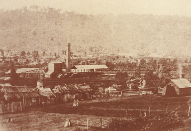 The Beechworth Burke Museum
Photograph, est. 1860-1875
... time when it was done. This image of the Rocky Mountain mine is historically significant as the mining complex is now non-existent, with the only remains being the tunnel built in 1880 by the company, which was considered one of the greatest engineering feats of the time. ...In 1875, the Rocky Mountain Extended Gold Sluicing Company Ltd was created, utilising the previous Rocky Mountain claim for the area near Lake Sambell. The company employed A.L Martin to survey an area for a tunnel underneath Beechworth and Johnson Stephens to dig it. The tunnel was built at a rate of 40 feet a month and eventually measured 800 metres. The tunnel was a true accomplishment both in the present and during the 19th century. It was considered to be a marvelous engineering feat. Beechworth is renowned for its hydraulic sluice method of mining. This involved soil being exposed to torrents of water from high-pressure hoses. From 1876 until its closure in 1921, the mine produced an astounding 47,926 ozs of gold. Companies like this were the source of income for many Chinese gold-diggers who sought to make their fortune on the goldfields of Beechworth. During the height of the rush, the town had around 7,000 Chinese inhabitants living on the outskirts of town as they were not permitted to live within Beechworth itself.The search for gold is ingrained into the history of Victoria and therefore, images like this one which portrays an open-cut sluicing site can reveal important information for society and technology for the date when the photograph was taken. This image is of important historical significance for its ability to convey information about sluicing and the methods used to find gold in 1910. It also shows a location where sluicing was undertaken which provides insight into the impact of sluicing on the environment at a time when it was done. This image of the Rocky Mountain mine is historically significant as the mining complex is now non-existent, with the only remains being the tunnel built in 1880 by the company, which was considered one of the greatest engineering feats of the time. The image also provides a first-hand look into the social and cultural networks at play during the 19th century with racial segregation of the Chinese at the 'Chinese Camp', as well as an insight into Beechworth's origins during the Gold Rush.A sepia rectangular photograph printed on matte photographic paper as a postcardReverse: Historic Beechworth / 7792.1 / ROCKY MOUNTAIN MINE / Viewed from the “Chinese Camp”, shown partly in the foreground, we see the central plant of the famous Rocky Mountain Mining Company. This extensive complex, of which nothing remains, was situated between Silver Creek and the present Lake Sambell area. The company was responsible for a tunnel cut through solid bedrock underneath the town of Beechworth and surfacing near the keystone bridge on the Wangaratta side. Completed in 1880 it was declared to be one of the greatest engineering feats in Australia. The tunnel is still basically intact today. / Series by Wooragee Graphics: Historic Beechworth. / COPYRIGHT BURKE MUSEUM / No.72 beechworth, rocky mountain mine, sluicing, gold rush, mining, gold -
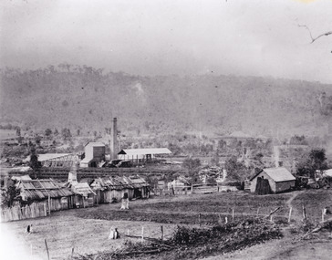 The Beechworth Burke Museum
Photograph - Photograph - Reproduction
... This image of the Rocky Mountain mine is historically significant as the mining complex is now non-existent, with the only remains being the tunnel built in 1880 by the company, which was considered one of the greatest engineering feats of the time. ...The photograph is a reproduction of a postcard from the Rocky Mountain Mining Company. In 1875, the Rocky Mountain Extended Gold Sluicing Company Ltd was created, utilising the previous Rocky Mountain claim for the area near Lake Sambell. The company employed A.L Martin to survey an area for a tunnel underneath Beechworth and Johnson Stephens to dig it. The tunnel was built at a rate of 40 feet a month and eventually measured 800 metres. The tunnel was a true accomplishment both in the present and during the 19th century. It was considered to be a marvelous engineering feat. Beechworth is renowned for its hydraulic sluice method of mining. This involved soil being exposed to torrents of water from high-pressure hoses. From 1876 until its closure in 1921, the mine produced an astounding 47,926 ozs of gold. Companies like this were the source of income for many Chinese gold-diggers who sought to make their fortune on the goldfields of Beechworth. During the height of the rush, the town had around 7,000 Chinese inhabitants living on the outskirts of town as they were not permitted to live within Beechworth itself.This image of the Rocky Mountain mine is historically significant as the mining complex is now non-existent, with the only remains being the tunnel built in 1880 by the company, which was considered one of the greatest engineering feats of the time. The image also provides a first-hand look into the social and cultural networks at play during the 19th century with racial segregation of the Chinese at the 'Chinese Camp', as well as an insight into Beechworth's origins during the Gold Rush.Black and white rectangular reproduced photograph printed on paperbeechworth, rocky mountain mine, sluicing, gold rush, mining, gold -
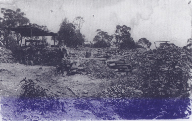 The Beechworth Burke Museum
Photograph - Photograph - Reproduction, Unknown
... An emigrant from Cornwall with experience in the tin mining industry, 19 year old Roger Williams senior sailed to New Zealand in 1840, then to Australia where he spent time in the Bendigo Gold Fields before settling in Beechworth in the early 1860s. Mr Williams senior worked on various mining activities in the district, including the Rocky Mountain Tunnel project. ...An emigrant from Cornwall with experience in the tin mining industry, 19 year old Roger Williams senior sailed to New Zealand in 1840, then to Australia where he spent time in the Bendigo Gold Fields before settling in Beechworth in the early 1860s. Mr Williams senior worked on various mining activities in the district, including the Rocky Mountain Tunnel project. ...This image is a reproduction of an 1899 original depicting the 'Williams Good Luck Mine' on the Mopoke Reef (also called 'Morepork Gully') in the Dingle Ranges, approximately three miles from Beechworth. The foreground of the image is littered with piles of smashed rock and detritus, known as ‘mullock’, beside a reinforced mine shaft, a vertical access passageway allowing miners to enter the mine and haul ore out using lifting technology such as a poppet heads, whims or windlasses. A group of miners and a dog appear close to an open-sided miner’s hut. Following the discovery of gold at Beechworth in 1852, rushes quickly followed at surrounding creeks and gullies in the district. In the late nineteenth and early twentieth centuries, small syndicates of miners continued to work old or abandoned quartz reefs, often persisting without the assistance of heavy machinery to remove the large amounts of rock, in order to obtain yields at ever greater depths. The group of miners in this photograph are Mr. Roger Williams and Sons, who revived operations at the ‘Old Good Luck’ mine on the Mopoke Reef in the Dingle Range near Beechworth around 1892, working the site for more than two decades. An emigrant from Cornwall with experience in the tin mining industry, 19 year old Roger Williams senior sailed to New Zealand in 1840, then to Australia where he spent time in the Bendigo Gold Fields before settling in Beechworth in the early 1860s. Mr Williams senior worked on various mining activities in the district, including the Rocky Mountain Tunnel project. Conversant with the character of gold-bearing reefs in the area, the syndicate dug an eight hundred foot tunnel, digging down as far down as two hundred feet with little capital save their labour, to connect and provide better working access to the mass of reefs and veins in the vicinity. Progress was hampered by poor air quality charged with fumes from dynamite and large quantities of rock had to be crushed to obtain payable yields. The Victorian Goldfields are filled with ruins and remnants of the area's rich mining history, ranging from small alluvial diggings to the remains of huge mining companies. Site names often changed several times throughout the nineteenth and twentieth centuries. Some sites were abandoned and forgotten, others were worked continuously over many decades. The names of mines were often repeated at different locations throughout the Victorian Goldfields. For example, there is a Mopoke Gully heritage mine near Fryers Creek, Victoria. 'Mopoke' is a common onomatopoeic name for Morepork and Australian Boobook owls. This image has historical, social and research significance for patterns of emigration during of the Victorian Gold Rush, and the historical, social and environmental impacts of mining at Beechworth at the turn of the nineteenth and twentieth centuries. As gold became scarce and government support and large company investment waned, poor hard-working miners laboured intensively to make a living through periods of high unemployment. This image can be compared and studied alongside other historical mining photographs and objects in the Burke Museum Collection. It has potential to improve our understanding of miners working conditions and the shifting character of mining in the Beechworth district. Black and white rectangular reproduction photograph printed on matte photographic paper.Obverse: Williams Good Luck Mine Beechworth / Roger! / Reverse: 6858 / burke museum, beechworth museum, beechworth, gold fields, gold rush, victorian gold rush, gold ming history, colonial australia, australian gold rushes, mining technology, beechworth historic district, indigo gold trail, migration, indigo shire, good luck gold mine, victorian goldfields, mining syndicates, gold fever, quartz-mining, small-scale mining, old good luck mine, mopoke gully, quartz reefs beechworth -
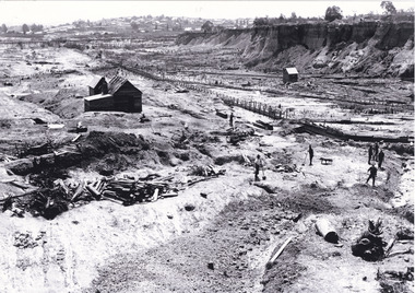 The Beechworth Burke Museum
Photograph, unknown
... When the mine closed in 1921, in a liquidation sale, Zwar purchased the tunnel and clear water supply that ran under the town of Beechworth. He directed the water to his tannery and over time built a major industry in leather works that was a major employer in Beechworth. ...This reproduced photograph is of Pennyweight Flat near Beechworth, a notable area of the 1850's gold rush in Victoria. Donald Fletcher, migrating to Beechworth from Scotland in 1855, had substantial claims at Pennyweight Flat and was amongst the first in the district to utilise hydraulic sluicing and water diverting methods.The flat is said to have seen a flurry of 200 miners to the area around 1857, and by 1861 when work commenced on extending Fletcher's tail race the census recorded 644 people residing there (European males, females and Chinese).The search for gold is ingrained into the history of Victoria and therefore, images like this one which portray an open cut sluicing site can reveal important information for society and technology for the date when the photograph was taken. This image is of important historical significance for its ability to convey information about sluicing and the methods used to find gold in 1910. It also shows a location where sluicing was undertaken which provides insight into the impact of sluicing on the environment at a time when it was done. This image is important for current research into the history of Beechworth and surrounding area including Victoria's North East. The Rocky Mountain Extended Gold Sluicing Company was a long running and very active mine that was one of the most successful and largest in the district. Therefore, this image has the capacity to be beneficial for research into society and the motivations of those living and working in this region during this period and therefore, has social significance. The Beechworth Burke Museum has additional images relating to gold sluicing which can be analysed and studied alongside images like this one. When the mine closed in 1921, in a liquidation sale, Zwar purchased the tunnel and clear water supply that ran under the town of Beechworth. He directed the water to his tannery and over time built a major industry in leather works that was a major employer in Beechworth. In growing his leather business, Zwar installed crude oil engines for electricity in his factory. He oversaw working with local council to introduce electricity to Beechworth via a sub-station on Albert Street. In 1927 Electric street lamps replaced gas lamps in the streets of Beechworth. Black and white rectangular reproduced photograph printed on glossy photographic paperObverse: Reverse: 84.222.5/ digital print/ rocky mountain extended gold sluicing company, gold, sluicing, gold sluicing, hydraulic sluicing, gold mine, open cut mining, mining, gold mining, north-east victoria, beechworth, burke museum -
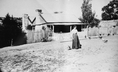 Eltham District Historical Society Inc
Negative - Photograph, Mary Jane Smart (nee Bailey) ouside the Smart family home in Bridge Street, Eltham, c.1915
... tunnel under the Yarra near Queen's-bridge when it col-lapsed. After he went to the West he sent me money regularly and wrote constantly. He came home three times — twice for a week or two at a time, the third time, eight years ago, when the Eitham railway was nearing completion. ...tunnel under the Yarra near Queen's-bridge when it col-lapsed. After he went to the West he sent me money regularly and wrote constantly. He came home three times — twice for a week or two at a time, the third time, eight years ago, when the Eitham railway was nearing completion. ...Located on the north side of Bridge Street at the intersection with Bolton Street, facing Bolton Street (now part of present day Brisbane Street and occupied by the Kitchen Design Centre). Show's an original early settler's cottage in Bridge Street. The cottage was built by Mrs Mary Jane Smart's parents, Edwin Bailey and Jane (nee Matthews). Mary Jane Smart was born in the cottage. She married an Englishman, Alexander Wilson Smart who disappeared to Western Australia in the early 1900s in search of gold. He ultimately married again in W.A., committing bigamy and then committed murder and was hung in 1911. This photo was taken c.1903 not long before both Mrs Bailey and her grand daughter both passed away. Jane Bailey died 2 Dec. 1904 and Mary Jane Smart and Ruby Jane Bertha Smart died July 1903 are all buried in Eltham Cemetery. SMART'S HOME AT ELTHAM. HIS WIFE AND SONS. In a little bush cottage surrounded by tall gum trees, through which appear glimpses of a willow fringed creek, of road ways hedged by masses of snowy flowering hawthorn, of growing crops and vividly green grazing paddocks, lives Mrs. Smart, the lawful wife of the man who is now in the hands of the police of Western Australia on suspicion of having committed a dreadful crime. Here, about half a mile out of the picturesque village of Eltham, she was born, and has lived her whole life — about 50 years. Smart himself lived here till the time when many years ago, the "lure of gold" got into his blood and he cleared out to Western Australia, to follow the digging rushes, gradually becom ing more and more estranged, till at length all communication ceased and be became lost to his wife and children. "I did not want him to go away," said Mrs. Smart, "because I had heard of so many men who had forgotten their homes in the excite ment of gold seeking, and of many others who died unknown and uncared for. But he would go, and when I saw his mind was set on it I placed no obstacles in his way. My parents built and lived in this cottage, where I was born, and they died in it. When I grew up I met my husband, a young Englishman, and married him. His name is Alexander, not Alfred, and his age is 52. We were very happy here, and although we were not well off we were comfortable, for he was a steady, sober, industrious man and had constant employment. He was just a manual worker, but could turn his hand to anything. We had five children, but one died. Four sons grew up in this little cottage. Thus three generations lived in it, somewhat unusual in an Australian bush home, I think. My eldest son is married and has a family; one is in Western Australia— not with his father— another is away working for him self, and one (indicating a young man by her side) has always stuck to his mother. He is my sole support, and he is as good to me now as his father once was. Yes, his father was a good, home-loving man in our younger days. He was fond of his children and was highly respected in these parts.' "It is fifteen years since my husband went away first. He had then been work ing for the Metropolitan Board of Works, and was engaged in the tunnel under the Yarra near Queen's-bridge when it col-lapsed. After he went to the West he sent me money regularly and wrote constantly. He came home three times — twice for a week or two at a time, the third time, eight years ago, when the Eitham railway was nearing completion. I induced him to stay till the railway opened, and he re-mained with me several months. I tried to get him to leave the West and settle down in his home, but he would not; he seemed restless and anxious to be off. One day when we were in Collingwood together he left me, saying he wanted to see what boats were going West. I implored him not to go away, and he said he would see. However, he returned to me soon after wards and said he had taken his ticket and would go by the next boat, and he went. For a year he wrote at irregular intervals, and then his letters ceased and I heard no more of him. For seven years I have not known whether he was alive or dead. Before that time my two sons in Western Australian used to see him some times, though they did not live with him; they used to tell me in their letters that he was well. It was a hard blow to be forgotten by him, but as my sons grew up I became more reconciled, and now I seem to look back at my life with him as some thing that happened a long time ago and is only a memory. Of his life and doings in Western Australia I know nothing. The last time I heard of him he was working in a foundry at Midland Junction. He was at Cue working on the railway when it opened there, and he caught the fever, but all that time he sent me money. When he returned the first time he took our eldest son with him, and the other boy followed later. They did not stay with him, how ever, and as far as I know they did not know how he lived." 'Mrs. Smart is a quiet, toil worn woman who has the respect of everyone who knows her.Roll of 35mm colour negative film, 3 strips Associated print from negative (Copy of original print)Fuji 100bridge street, cottage, smart home, houses, mary jane smart (nee bailey), smart family home, alexander wilson smart, bigamy, bush cottage, early settlers, eltham, jane bailey (nee matthews), murder, ruby jane bertha smart -
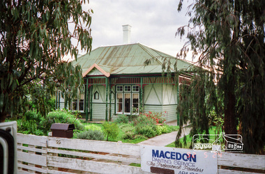 Eltham District Historical Society Inc
Photograph, 35 Ingrams Road, Research, Eltham Heritage Tour, 24 May 1992, 24/05/1992
... Maroondah Dam was constructed in. 1920 to replace the original weir and at that time: the Aqueduct - as established into the landscape - with bridges and tunnels and pine trees were used to stop rubbish polluting the water."...Maroondah Dam was constructed in. 1920 to replace the original weir and at that time: the Aqueduct - as established into the landscape - with bridges and tunnels and pine trees were used to stop rubbish polluting the water." ...ELTHAM HERITAGE TOUR The Society excursion on 24th May 1992 was arranged by David Bick, leader of the team carrying out the Shire's heritage study. David selected a number of sites or buildings identified in the study, some of them lesser known components of the Shire's heritage. The tour commenced at the Eltham Shire Office at 10.00 am. Travel was by private car and mini-bus with stops at about twelve locations for commentary by David.It included a short walk in Hurstbridge and lunch at Kinglake. Highlights of the tour included: - 10 am Leave from Shire Offices - 3 Important Trees - A Physical Link to Eltham's First Settlers - Toorak Mansion Gates - A Surviving Farm House - An Intact Circa 1900 Main Street - First Settlers - Gold Miners, and Timber-getters - An Early Hotel - A Pioneering Homestead - Changing Eltham Shire - 20th Century - 4 pm Afternoon Tea and Finish Tour Extract from ELTHAM CULTURAL HERITAGE TOUR (Newsletter No. 85, July 1992, by Bettina Woodburn) "On a right-angle turning of the Eltham Road is Wellers Pub, a Cobb & Co. coaching stop on the way to distant gold-fields and places north of the Yarra River. The Hotel dates from the 1870's. Daily distances for a bullock team was eight miles, horses could do double that distance. We turned into Cassells Road and on the corner of Ingrams Road we admired an elaborate Edwardian villa, 1900 style. The Aqueduct conveying Melbourne's water supply was a communication line and a technological advance in 1891. It has been enlarged and re-faced and no longer used here but piped underground. Proclaimed a linear park it has reverted to crown land, controlled by local Council. Maroondah Dam was constructed in. 1920 to replace the original weir and at that time: the Aqueduct - as established into the landscape - with bridges and tunnels and pine trees were used to stop rubbish polluting the water."Record of the Society's history and activities and highlighting various aspects of the Heritage Study undertaken by David Bick used to create the future heritage overlay for the Shire of Eltham and later Nillumbik Shire.Roll of 35mm colour negative film, 4 stripsKodak Gold 100 5095shire of eltham historical society, activities, heritage tour, ingrams road, research (vic.) -
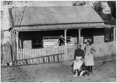 Eltham District Historical Society Inc
Negative - Photograph, Smart family home in Bridge Street, Eltham, c.1903
... tunnel under the Yarra near Queen's-bridge when it col-lapsed. After he went to the West he sent me money regularly and wrote constantly. He came home three times — twice for a week or two at a time, the third time, eight years ago, when the Eitham railway was nearing completion. ...tunnel under the Yarra near Queen's-bridge when it col-lapsed. After he went to the West he sent me money regularly and wrote constantly. He came home three times — twice for a week or two at a time, the third time, eight years ago, when the Eitham railway was nearing completion. ...Believed to be Mrs Jane Bailey (nee Matthews) (d. 1904) and her grand-daughter Ruby Jane Bertha Smart (1890-1903) in front of the Smart family cottage in Bridge Street, Eltham, c.1903 Located on the north side of Bridge Street at the intersection with Bolton Street, facing Bolton Street (now part of present day Brisbane Street and occupied by the Kitchen Design Centre). Ruby Jane Bertha Smart born abt 1890 died in 1903 in Eltham. Her brother Alfred Francis Smart was born abt 1887 and died 1966 in Mont Albert, Vic. (Accessed via Ancestry.com) Show's an original early settler's cottage in Bridge Street. The cottage was built by Mrs Mary Jane Smart's parents, Edwin Bailey and Jane (nee Matthews). Mary Jane Smart was born in the cottage. She married an Englishman, Alexander Wilson Smart who disappeared to Western Australia in the early 1900s in search of gold. He ultimately married again in W.A., committing bigamy and then committed murder and was hung in 1911. This photo was taken c.1903 not long before both Mrs Bailey and her grand daughter both passed away. Jane Bailey died 2 Dec. 1904 and Mary Jane Smart and Ruby Jane Bertha Smart died July 1903 are all buried in Eltham Cemetery. SMART'S HOME AT ELTHAM. HIS WIFE AND SONS. In a little bush cottage surrounded by tall gum trees, through which appear glimpses of a willow fringed creek, of road ways hedged by masses of snowy flowering hawthorn, of growing crops and vividly green grazing paddocks, lives Mrs. Smart, the lawful wife of the man who is now in the hands of the police of Western Australia on suspicion of having committed a dreadful crime. Here, about half a mile out of the picturesque village of Eltham, she was born, and has lived her whole life — about 50 years. Smart himself lived here till the time when many years ago, the "lure of gold" got into his blood and he cleared out to Western Australia, to follow the digging rushes, gradually becom ing more and more estranged, till at length all communication ceased and be became lost to his wife and children. "I did not want him to go away," said Mrs. Smart, "because I had heard of so many men who had forgotten their homes in the excite ment of gold seeking, and of many others who died unknown and uncared for. But he would go, and when I saw his mind was set on it I placed no obstacles in his way. My parents built and lived in this cottage, where I was born, and they died in it. When I grew up I met my husband, a young Englishman, and married him. His name is Alexander, not Alfred, and his age is 52. We were very happy here, and although we were not well off we were comfortable, for he was a steady, sober, industrious man and had constant employment. He was just a manual worker, but could turn his hand to anything. We had five children, but one died. Four sons grew up in this little cottage. Thus three generations lived in it, somewhat unusual in an Australian bush home, I think. My eldest son is married and has a family; one is in Western Australia— not with his father— another is away working for him self, and one (indicating a young man by her side) has always stuck to his mother. He is my sole support, and he is as good to me now as his father once was. Yes, his father was a good, home-loving man in our younger days. He was fond of his children and was highly respected in these parts.' "It is fifteen years since my husband went away first. He had then been work ing for the Metropolitan Board of Works, and was engaged in the tunnel under the Yarra near Queen's-bridge when it col-lapsed. After he went to the West he sent me money regularly and wrote constantly. He came home three times — twice for a week or two at a time, the third time, eight years ago, when the Eitham railway was nearing completion. I induced him to stay till the railway opened, and he re-mained with me several months. I tried to get him to leave the West and settle down in his home, but he would not; he seemed restless and anxious to be off. One day when we were in Collingwood together he left me, saying he wanted to see what boats were going West. I implored him not to go away, and he said he would see. However, he returned to me soon after wards and said he had taken his ticket and would go by the next boat, and he went. For a year he wrote at irregular intervals, and then his letters ceased and I heard no more of him. For seven years I have not known whether he was alive or dead. Before that time my two sons in Western Australian used to see him some times, though they did not live with him; they used to tell me in their letters that he was well. It was a hard blow to be forgotten by him, but as my sons grew up I became more reconciled, and now I seem to look back at my life with him as some thing that happened a long time ago and is only a memory. Of his life and doings in Western Australia I know nothing. The last time I heard of him he was working in a foundry at Midland Junction. He was at Cue working on the railway when it opened there, and he caught the fever, but all that time he sent me money. When he returned the first time he took our eldest son with him, and the other boy followed later. They did not stay with him, how ever, and as far as I know they did not know how he lived." 'Mrs. Smart is a quiet, toil worn woman who has the respect of everyone who knows her.This photo forms part of a collection of photographs gathered by the Shire of Eltham for their centenary project book,"Pioneers and Painters: 100 years of the Shire of Eltham" by Alan Marshall (1971). The collection of over 500 images is held in partnership between Eltham District Historical Society and Yarra Plenty Regional Library (Eltham Library) and is now formally known as the 'The Shire of Eltham Pioneers Photograph Collection.' It is significant in being the first community sourced collection representing the places and people of the Shire's first one hundred years.Digital image 4 x 5 inch B&W Neg Original print 10.5 x 16.5 cmFor postcard print: Inscribed on envelope: "Return to Mrs H. Butherway, 22 Bridge St, Eltham." Also "Photo Mrs Clark Hampton (nee Smart), original Smart's house - Bridge Street, 95 years ago." Also "Right - Mrs Clark's grandmother Mrs J Smart Left - Her daughter Ruby dies soon after photo taken. Brother Alf Smart died about 6 years ago." Inscribed on back of photo "247 Vincent St, Leederville" It is believed that this inscription may be somewhat mixed up.sepp, shire of eltham pioneers photograph collection, eltham, bridge street, alexander wilson smart, bigamy, bush cottage, early settlers, houses, jane bailey (nee matthews), mary jane smart (nee bailey), murder, ruby jane bertha smart, smart family home, smart home