Showing 4037 items
matching hill's house
-
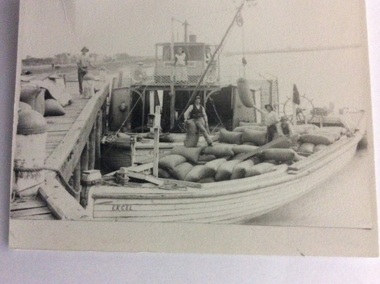 Port of Echuca
Black and white photograph, Before 1920
The P.S Clyde was built in 1884 by W.Wilson, in Echuca and was owned by the Evans Bros. It sunk in the Murrumbidgee river in 1920 and was raised and converted into a barge in 1922. The barge Excel was built as the Barge Adam in 1897. It was owned by the Permewan Wright Co. and renamed barge 'Excel' in 1909. (Ref ; Parsons, Ronald, "Ships of the Inland Rivers" This photograph must have been taken before 1920 when the P?S Clyde was still a paddle steamer.One of two black and white photographs of the P.S Clyde and the barge Excel moored to a wharf, possibly at Swan Hill. People are on the wharf and both vessels. There is a crane fitted on the Clyde loading, bags of wheat. A woman is standing in front of the wheel house. There is a man inside the wheel house. Steering mechanism appears to be attached at the back of the barge, and there also appears to be a flag flying on the back of the barge. Three men are on the barge supervising the loading process.Written on the back of the smallest photograph are the words "2nd copy in Clyde file." On the barge in the photograph is the word 'EXCEL' 'and the word 'Clyde' can be seen on the bow of the paddle steamer .p.s.clyde, excel, adam, evans bros, murrumbidgee river -
 Eltham District Historical Society Inc
Film - Video (VHS), Diamond Creek Fire Brigade, c.1955-1987
Combination of three movie films. Movie One (1950s): 00:00 – 13:14 Black and white footage of Diamond Creek firemen practising in Diamond Street in the 1950s for forthcoming demonstrations of abilities. Mentions of Gordon Brandy and Joe Hislop Running out hoses from old hose reels along Diamond Street, Diamond Creek Displays from various brigades running out and connecting hoses. Also scenes from the 1950s of Diamond Creek Fire Brigade competing in various locations around Victoria and Tasmania. Mentions of Brigade members Dave Kidd, Bruce Hackett, Ron Kirkbride, Jack Marks, Graham Upton who are prominent in these events. Members of Kyneton Fire Brigade also present. Members competing in running out hose reels, connecting hoses togethers and to hydrants then climbing towers to direct water from hose or at a target hanging above the road. Diamond Creek members identified wearing a diamond on their chest and back. Includes scenes of Scottish pipe bands at the events and significant crowds of spectators. Footage of Mel Stone and Beryl Marks, Stan Redpath and Ron Kirkbride, then Ron Kirkbride and Eric Holt viewing flower displays. Film changes to colour at Diamond Creek oval for practice with fire engine entering oval. Members depicted include Bill May, Jack Sinclair, Jim Cox, Bob Beale, Dave Kidd, Bruce Hackett and Captain Clarrie Stone. Reverts to black and white in the 1950s where the Brigade joins forces with the Diamond Valley Community Hospital for a Gala Day on the Diamond Creek Oval. Changes to colour again, possibly same event and scenes of children on bikes and scooters or with prams and carts racing around the oval. Mention of young lad Brian Laurie who has his own fire truck. Dart throwing, pony rides. Scenes with Dr Don Cordner, Gus Lyons, Vic Cohn (?) and spinning wheel and Diamond Creek School children entertain a large crowd with Maypole dancing. Movie Two (1950s): 13:25 – 19:00 This black and white film was taken by a TV film crew in the 1950s depicts a typical call out for the Diamond Creek Fire Brigade. In this case the careless action of a member of the public throwing a lighted match from a car, which can cause extensive damage. Footage features the Shire of Eltham War Memorial tower at Kangaroo Ground before it was modified with a fire spotter’s cabin. Discusses fire spotting operations from the tower. Shows a fire spotter walking around the top of the tower. A fire is detected, and the information is relayed to the nearest fire station, in this case, Diamond Creek. The telephone call is received, and the alarm sounded. Captain Clarrie Stone and firemen May and Shaw leave their workplaces and prepare for action. Scenes of running across the Main Hurstbridge road showing the shops (Shell service station and Chemist prominent). Scenes entering the fire station which has a pictorial warning covering the entire door “Only you can prevent forest fires – If you’re careless – we’re homeless!” Eric Holt pinpoints the location of the fire while Captain Clarrie Stone and Fireman Shaw take note. The advance vehicle (an FE Holden ute, rego GTE-696) leaves to assess the extent of the fire. Having assessed the fire, Fireman Shaw communicates with base showing radio with call sign VL3JZ. Eric Holt takes the call. In the meantime, Captain Clarrie Stone and Fireman Shaw undertake some limited action to address the fire. Firemen Bill May, Jim Bates and Hugh Bar (?) man the tanker. A photo portrait of Queen Elizabeth is visible hanging on the wall. They are later joined by Firemen Jim Cox, Eric DeBuse (?) and Jack Marks. The tanker is seen departing the station and diverging off before the bridge. Captain Clarrie Stone and Fireman Shaw are seen pumping water on the flames with hand pumps when the tanker arrives. The hose is unreeled, and water turned on the flames. Jack Sinclair joins the action. Jim Cox directs water to the high stuff. The fire put out, Jack Marks and Eric DeBuse wind in the hoses and the team head back to town. It’s peaceful again at the memorial tower. Movie Three (1969-1987): 19:14 – 34:34 Colour film “Fired with Dedication”, Country Fire Authority Victoria, produced by I.L. Wadeson, Commentary by A.M. Hem. Credits with CFA Victoria emblem and then placed over a view of an old-style ladder engine. Opens with the scene of a fire engine outside the Diamond Creek Fire Station then various trophies reflecting the competition success of the brigade in various track and disciplined events. Two trophies shown of particular pride to the brigade were for first place in the Torchlight Procession at the State Championships in Mildura in 1986 and also at Swan Hill in 1981. Still photo scenes of ex Captain Clarrie Stone, Brigade Captain for 21 years; ex Captain Jack Marks, 10 years; ex Captain Ian Douglas, 10 years. Cuts to scene of radio control room, January 1969, and news of a fire on the northern side of the township of Diamond Creek. With scenes of flames in bush, the narration explains that until the early 1960s the area was an orchard district which protected the town against the savagery of bushfires. But due to competition from other areas more suitable for orcharding and easier transport to Melbourne the district could no longer remain competitive, and orchards were replaced by grassed areas, which together with the bush areas were a feeding ground for fire. On 8th January 1969, high temperatures and strong north winds, were, with the carelessness of some individual all that was necessary to produce the worst fire the district had seen. Cuts to scene of blackened fields and cattle - Hundreds of hectares of grass land were blackened, and cattle had to be transported to other areas for agistment. Scene of destroyed buildings in the township – 13 houses and the public hall in the town were destroyed as was the theatre equipment which was owned by the fire brigade. The Church of England Hall and bell tower were badly damaged. The whole town could have been burnt out but for the determination, skill, and courage of the Diamond Creek Fire Brigade. Scenes of all that was left of the home on the hill on the west side of the Church of England. Also, the remains of the old Pisy (?) home on the top of the same hill near Lambert Street, and the ruined Crocker home. Cuts to a scene in the mid-1970s to mid-1980s of a house fire in Haley Street attended by the Diamond Creek Fire Brigade. Although the house was severely damaged, it was saved. Mentions that whilst assistance is appreciated, in some circumstances, those doing so are not properly dressed for fighting fires. Breathing apparatus is a must in structure fire attack. Next scene (either on Mangarook or Coventry oval) showing off four Diamond Creek Fire Brigade efficient and very expensive firefighting units. Features a forward control vehicle Toyota 4WD used for conveying task force personnel to the required areas; a Hino Model 3.2 tanker, diesel powered and carries 3,000 litres of water and has a 16 HP petrol driven pump which delivers 900 litres of water per minute; an International tanker (registration TCM-418) which carries 3,000 litres of water with pumping capacity of 600 litres per minute. The Ford diesel powered pumper (registration MXE-754) is a well-equipped vehicle with a water capacity of 1,000 litres and capable of pumping 1,900 litres of water per minute from the main pump, has many lockers which hose equipment such as breathing apparatus and various types of hose nozzles and foam making equipment. The vehicle carries 360m of 64mm diameter hose which can be laid out from the rear lockers and a portable lighting plant, an Oxy Viva resuscitator to revive smoke inhalation victims and forcible entry tools to gain access to structure fires. Views of the main pump and control panel on the vehicle. As well as the main pump, the vehicle is equipped with an auxiliary pump which allows the facility to pump whilst moving. Fire fighters must undergo constant training and hone their skills, Scenes of a training exercise using the pumper to pump from static water. First, the short lengths of suction hose are coupled, a strainer fitted to ensure debris does not foul the pump. Gauges must be constantly monitored to ensure manageable water pressures are maintained. Pressures are normally controlled to allow two fire fighters to work at each nozzle outlet. Two nozzles are tested, one adjustable jet fog type which is used on flammable gasses or within a structure fire to absorb heat. A straight jet nozzle to project water long distances to protect exposed surfaces close to a fire radiated heat. The pumper is quite a versatile vehicle in handling structure fires, but it also carries specialist equipment needed in containing hazardous chemical incidents. Cuts to scene of parade – the Diamond Creek Fire Brigade has with other neighbouring brigades participated in most town fairs and earns the respect of the watching public. It can be seen why this brigade has been so successful at disciplined contests. Views of Plenty Fire Brigade Road Rescue unit which is equipped with the “Jaws of Life” Scenes of athletic competitions – many neighbouring brigades indulge in friendly but keen competition at the Diamond Creek Town Fair. The young are also encouraged to participate in all aspects of Junior Fire Brigade activities and become tomorrow’s generation of volunteer fire fighters. Scene of the 1986 Diamond Creek Town Fair which was the last time veteran Captain Clarrie Stone BEM marched with the brigade. Clarrie was awarded the British Empire Medal for his service to the Country Fire Authority. Also, scenes of vehicles in the parade. Cuts to scene of brigade members in drill formation for inspection by Acting Chief Harry Rothsay (?) on the occasion of the opening of the new fire station extensions on August 29, 1987. Rudy Libel (?) Captain at the time. Scenes of crowds including many dignitaries of neighbouring brigades present including Lieutenant Gordon Grandy (who came down from Queensland for the occasion) and ex-Secretary David Kidd and wife Betty, also ex Captain Clarrie Stone and Mrs Nel Stone, a life member of the Ladies Auxiliary, the Reverend Jock Ryan, son of J.L Ryan, founder of the Diamond Creek Fire Brigade, Foundation Captain of the fire brigade, Keith Bradbury and Mrs Bradbury. Pauline Dick accepts a community service award for services to the CFA. Recognising over 47 and a half years of service, a presentation is made by Mr Neil Marshall, Acting Chairman of the CFA to ex Captain Clarrie Stone with response by Clarrie. Other members of the official party include Cr. Martin Wright, Shire President Wayne Phillips and local Member of Parliament, Mrs Pauline Toner. Ex foreman John Bennett is presented with a life member’s awards by Captain Rudy Libel. The camera also catches Gwen Cox, Jean Ryan and Bessie Layton (?) Provides historic footage of people, places and equipment and a record of the worst fires expoerienced in Diamond Creek in 1969BASF Standard Quality SQ E-180 VHS dubbing (poor quality) of three films Converted to MP4 file format 0:34:38, 1.85GBOn label: "Donation - August 2000 Diamond Creek Unit Old films made up from Fire Brigade shows at competitions - also Kangaroo Ground Tower being used"video recording, diamond creek fire brigade, 1986 diamond creek town fair, a.m. hem, acting chief harry rothsay, athletic competitions, beryl marks, bessie layton, betty kidd, bill may, bob beale, brian laurie, bruce hackett, captain clarrie stone, chemist, church of england hall, clarrie stone, clarrie stone bem, country fire authority victoria, coventry oval, cr. martin wright, crocker home, dart throwing, dave kidd, david kidd, diamond creek, diamond creek fire station, diamond creek oval, diamond creek school, diamond creek town fair, diamond street, diamond valley community hospital, dr don cordner, eric debuse, eric holt, fe holden ute, fire damage – buildings, fire spotter, fire spotter’s cabin, fire station extension, fired with dedication (film), firefighting units, fireman shaw, firemen jim cox, ford pumper, foundation captain, gala day, gordon brandy, gordon grandy, graham upton, gus lyons, gwen cox, haley street, hino model 3.2 tanker, house fire, i.l. wadeson, ian douglas, international tanker, j.l ryan, jack marks, jack sinclair, january 1969, jaws of life, jean ryan, jim bates and hugh bar, jim cox, joe hislop, john bennett, kangaroo ground, kangaroo ground tower, keith bradbury, kyneton fire brigade, lambert street, main hurstbridge road, mangarook oval, maypole dancing, mel stone, mildura 1986, mrs bradbury, mxe754 vic registration, neil marshall, nel stone, orchard district, oxy viva resuscitator, pauline dick, pauline toner mp, pisy home, plenty fire brigade road rescue unit, pony rides, radio control room, reverend jock ryan, ron kirkbride, rudy libel, shell service station, shire of eltham war memorial, shire president wayne phillips, spinning wheel, stan redpath, state championships, swan hill 1981, tcm418 vic registration, torchlight procession, toyota 4wd, trophies, vic cohn, victorian bushfires - 1969, vl3jz -
 Eltham District Historical Society Inc
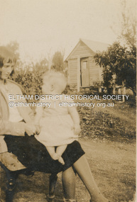
Photograph, Rita Teagle with baby at Thomas Street house, Eltham, c.1938
Rita Teagle House belonged to Tom Fielding's grandparents (Margaret Teagle and Richard Fielding). It was at top of the hill on right hand side (no. 10 Thomas Street, Eltham) Pictured is a bungalow behind the main house. These were added on every time more children came along. Rita was born 1910 and married Horace Maclaughlin in 1935. They had a son, Brian Lawrence Maclaughin (1937). It is presumed that Brian is sitting on Rita's lap and that the date of the photo is c.1938.On reverse "Rita Teagle"brian lawrence maclaughin, eltham, house, ingram family, rita agnes maclaughlin (nee teagle), teagle family, thomas street, pam thoonen (nee ingram) collection -
 Eltham District Historical Society Inc
Document - Folder, Eltham Banner Project, 1986
Newspaper articles about the As We Are Eltham Banner Project undertaken within the Shire of Eltham 1. Eltham banner to celebrate environment, Diamond Valley News, Tuesday, September 16, 1986, p16 2. Group paints for peace, Diamond Valley News, Tuesday, September 30, 1986, p2 3. Banners show people of Eltham as they are, Diamond Valley News, Tuesday, October 14, 1986, pp12-13 4. Banners fly high at lastt, Diamond Valley News, Tuesday, October 21, 1986, p17 Also various advertisements from businesses within the shire Newspaper clippingsas we are, banner project, eltham banners, meruka house, sarah houseman, advertising, eagle screens & blinds, 1986, alistair knox park, bob manuell, don brown, dooncal air coinditioning and central heating, eltham festival, eltham outdoor art show, eltham peace banner, eltham town park, grand parade, pauline therese toner, peter wilson, research shops, river of life banner, shire of eltham acquisitive award, valley carpets, 16 sherbourne road briar hill, 22 were street montmorency, 1177-1181 main road eltham, barry reading goumet butchers, eltham hardware & plumbing supplies pty ltd, hutchinsons garden supplies, 38 bridge street eltham, artists, costless clearance centre, cr bob manuell, jud duigan, margaret cherry, tracey naughton, woolworths arcade, anthea morrison, beyond the end of the line, diamond valley musical society, eltham college, eltham community festival, eltham high school, eltham service club, geraldine veerman, ian robertson, 19 were street montmorency, arnold thomas, arnolds recycling centre, kevin mcnamara, luck street eltham, mcewans, montmorency hardware, peel street eltham, tim payze, 1022 main road eltham, as we are banner exhibition, jud degan, marg cherry, the cut ahead, arthur street, eltham mall, flexiteller, national australia bank -
 Eltham District Historical Society Inc
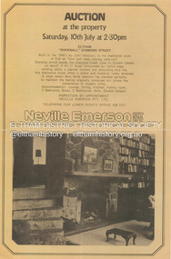
Document - Property Binder, Rocknall, 25 Diamond Street, Eltham
1. Photo reprint of Auction sale brochure, 10 July 1993 2. A4 photo reprint of four photos (3 x B&W of the house when purchased by Pam Robinson and 1 x clr of Pat Begg at work on extension) 3. A4 photo reprint of four clr photos of Pat Begg at work on extension Items 1-3 donated by Pam Robinson August 2021 via Wendy Wilson in support for a Newsletter article "Eltham Insights" by Pam Robinson published in the EDHS newsletter No 260, October 2021. Also Newsletter No. 265 August 2022 "Harcourt Hill" by Carlotta Quinlan features Rocknall and one of Pam Robison's photos.eltham, 25 diamond street, auction sale, j.m. harcourt design, neville emerson real estate, pam robinson, pat begg, rocknall -
 Eltham District Historical Society Inc
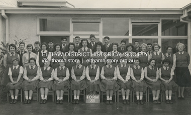
Photograph, Classic Photos, Form 3A, Eltham High School, 1960
Dr Gary Presland advised the following in October 2020: "In 1959 my parents bought a house in Church Street, Panton Hill. For about three and a half years previously, they had farmed a property 15 km south of Echuca, before moving, briefly to Melbourne. After moving to Panton Hill, I was enrolled at Eltham HS, in Form 2 (Year 8). I completed that year, and in 1960 was in Form 3A (at which time the photograph was taken). To reach the school, I caught a bus each day, from Panton Hill. Early in 1960, my parents decided to separate. My mother left with the youngest two of my three siblings, leaving me and a younger brother with our father in Panton Hill. My brother was in Year 7 at the High School. After a few months, my father and I had a falling out and my brother and I left home to join our mother in South Melbourne. For the remainder of the 1960 school year we travelled each day by train from Melbourne to Eltham. In 1961 I was enrolled at Melbourne Boys High School, which was the nearest secondary school to where I was then living."Written in pencil on back: "Gary Presland - 4th from left, back row Eltham HS, 1960" Also stamped in purple ink on back "Classic Photos"1960, class photo, eltham high school, gary presland -
 Eltham District Historical Society Inc
Photograph - Digital Photograph, Alan King, Former Police Residence, 728 Main Road, Eltham, 28 December 2007
The institutions of law and order in Colonial Victoria included the police, courts and prisons. The 1852 report of the Snodgrass Select Committee appointed to "identify the policing needs of the colony” noted there existed seven independent police forces that did not co-operate or regularly communicate. Following the committee's report all these police entities were merged into the Victoria Police, founded on 8 January 1853, to implement law and order responsibilities throughout the Colony of Victoria. The Eltham Courthouse (1860) and adjacent Police Residence (1859) formed a justice precinct established in the immediate aftermath of the 1852 police inquiry and the effects of the gold rush. The physical presence of these buildings, in the centre of the early Eltham township, defined centralised control over law and order. In the early days the Police Constable in charge would conduct his duties travelling around the district by horse; a stable was located at the rear of the residence. At times the horse would be grazed on the paddocks across the road. Horseshoes were forged by the blacksmith beside the Courthouse on the high side of “Policeman’s Hill”. Along with the stable, there was a two-cell bluestone lockup where prisoners were held awaiting trial in the adjacent Courthouse. Their meals were usually provided by the policeman’s wife or from the hotel just up the road. With the arrival of the railway in 1902 the town centre gradually shifted towards the railway station. The Police Station and operations were moved into the town centre in 1961 to a renovated house in Pryor Street, which was later replaced by the current Police Station. From 1961-1981 the residence was occupied by the Vermin and Noxious Weeds Destruction Section of the Department of Crown Lands and Survey. Prior to August 1967 the former Police Station was dragged to the rear of Police Residence to make way for the construction of a driveway and access from Main Road. The building was placed on the site of a former Scullery and modified for Lands Department use. In 1981 the Shire of Eltham took over management of the former Police Residence in Eltham. It remained unoccupied for a period whilst its future was discussed in Council. It was then used for a community job creation scheme until 1985. In 1985 the Shire of Eltham Parks and Environment occupied the residence. Council improved the driveway but later added a second rear access from Brougham Street due to the dangerous nature of the Main Road entrance. Additionally, a rear toilet facility between the Police Residence and the relocated former Police Station, which was doubling up as a lunchroom. Council also commenced discussions to re-establish a replica Police Station. Around November 1986 the former Police Station was demolished; believed to have been suffering termite damage. About 1989, after some years of discussion, a replica Police Station was built, based on photographs, to act as a lunchroom and meeting room for the Parks and Environment staff and volunteers doing community service. In 1996 Eltham District Historical Society held discussions with Nillumbik Shire Council commissioners throughout the year regarding a home for the Society. A proposal was put forward by the Society in October to occupy the former Police Residence. In March 1997 Eltham District Historical Society gained access to former Police Residence and on July 12, 1998, moved into its Local History Centre. In July 2018, Eltham District Historical Society gained access to the replica Police Station (which had been used as a music library and storage for the Eltham Concert Band) for use as part of regular heritage tours for schools and community-based groups. Covered under Heritage Overlay, Nillumbik Planning Scheme. Published: Nillumbik Now and Then / Marguerite Marshall 2008; photographs Alan King with Marguerite Marshall.; p65This collection of almost 130 photos about places and people within the Shire of Nillumbik, an urban and rural municipality in Melbourne's north, contributes to an understanding of the history of the Shire. Published in 2008 immediately prior to the Black Saturday bushfires of February 7, 2009, it documents sites that were impacted, and in some cases destroyed by the fires. It includes photographs taken especially for the publication, creating a unique time capsule representing the Shire in the early 21st century. It remains the most recent comprehenesive publication devoted to the Shire's history connecting local residents to the past. nillumbik now and then (marshall-king) collection, eltham, main road, eltham district historical society, eltham justice precinct, little eltham, local history centre, police residence, police station -
 Eltham District Historical Society Inc
Map (item) - Sales Brochure, Plenty Township Estate and Bryn Teg Hill's Estate, Coghill & Haughton, Melbourne, c.1924
Plenty Township Estate "The rapid growth of Greensborough and the great traffic development on the main road between Heidelberg and Eltham augurs well for Plenty Township Estate. Already a Store, Post Office and State School have been started, and the activities of the Local Progress Association will help the district forward considerably. Within walking distance of the Montmorency and Greensborough stations." Bryn Teg Hill's Estate "Better known as "The Old Sand Hill, "within walking distance of the Montmorency and Greensborough railways stations." "Some few years back Mrs Thomas subdivided portion of the Sand Hill Paddocks, and the areas sold have been settled and many converted into charming outer suburban garden homes with cultivation and orchard plots. The south-eastern slope gives the land a grand outlook over the Yarra Valley on to the Dandenoings, and the are is very picturesque and homely." "A number of the blocks contain large deposits of valuable building sand, which should prove good speculation in view of the forecast for further rapid home development along the Eltham Suburban Electric Service." Sand Hills Road (Old Eltham Road) Date estimated as c.1924 - Electricification of railway line to Eltham referenced on map occured April 1923 and Mrs Mary Thomas died August 1925. Her home Bryn Teg became part of the Heidelberg Golf Club in 1927.The establishment of Lower Plenty as a suburban growth area supported by easy commuting facilitated by the elctrification of the Eltham railway linebonds road, bridge, bryn teg hill's estate, coghill & haughton, eltham road, heidelberg golf club hotel, houses, lower plenty, lower plenty bridge, lower plenty road, main road, plenty hotel, plenty river, plenty township estate, real estate agent, sales brochure, sand hills road, the old sand hill, sand hill paddocks, woodfull road, old eltham road, bryn teg, mrs m thomas -
 Eltham District Historical Society Inc
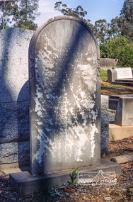
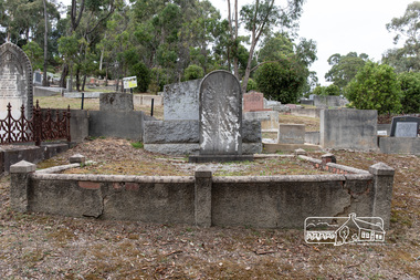
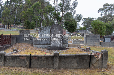
Negative - Photograph, Harry Gilham, Grave of Janet and William Morris, Eltham Cemetery, Victoria, Sep 2009
William Morris was born in Little Eltham in 1851. He was married three times; his second wife had the same surname as his first so they may have been sisters. He was described as "jolly and hearty" and ran a publican's booth at the Eltham Races in 1903, reportedly doing a good trade. He was an Eltham Shire Councillor between 1897 and 1918 and was Shire President in 1911. The Evelyn Hotel was situated in Main Road Eltham, immediately opposite its competitor the Eltham Hotel. It had opened as the Fountain of Friendship Hotel by 1854, when it was described as having "twelve spacious apartments all canvassed and papered", but had changed its name by 1878. The proprietor from about 1889 until 1919 was William Morris; he was also the licensee for most of that time. (The William Morris who was a butcher at Eltham in the early 1900s was no relation.) It advertised that it had "good stables", located behind the hotel in Pitt Street, a necessity for hotels at the time. Mail coaches en route from Heidelberg to Queenstown (now St Andrews), Panton Hill and Kangaroo Ground changed horses there. It was de-licensed as a hotel in 1919 but continued to operate as a boarding house until it was destroyed by fire in 1931. William died in 1922 and is buried in Eltham Cemetery with several other family members. Janet The Beloved Wife of William Morris Who died 5th October 1880 Aged 24 years Also Alfred George Morris Died 11th September 1880, aged 1 year Also William Morris Died 8th December 1922 Aged 74 years At RestRoll of 35mm colour negative film, 6 stripsKodak GC 400-9eltham cemetery, gravestones, alfred george morris, janet morris, william morris, evelyn hotel -
 Eltham District Historical Society Inc
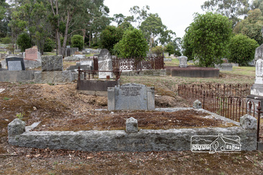
Photograph, Peter Pidgeon, Grave of John and Mary Murray, Eltham Cemetery, Victoria, 5 April 2021
Irish-born John Murray and his wife Mary (daughter of Thomas Sweeney) married in 1849 and settled in Eltham North. John and Mary were amongst the earliest inhabitants of Eltham. John was a farmer and their block of about 80 acres, called ‘Laurel Hill’, was on the eastern side of the Diamond Creek, extending east to beyond Zig Zag Road. It was later extended southward by the purchase of a further 60 acres. He is recorded as a supporter on the petition for a school in Eltham and he served on the National School Board of the Eltham school. John died in 1867 and is buried in Eltham Cemetery with Mary and with two of their grandchildren. Their eldest son Johnnie inherited the property. Then in about 1902 his younger brother James purchased about 50 acres on the western side of the Diamond Creek immediately opposite Laurel Hill, extending west to slightly past Wattletree Road. Eltham North Reserve now lies just beyond the southern boundary. James built a family home on top of the hill on the northern boundary, together with a dairy and milking shed and a food cellar. It is thought that the barn with stables was already there. When Johnnie died in 1912, the two properties (though severed by both the creek and the railway line) effectively merged. The land was worked as an orchard with apples, pears, quinces, and possibly apricots and peaches. Later it became a dairy farm. By 1986, almost all the land had been sold off for residential subdivision and the house had been condemned as unfit for habitation. John's grandson Jim retained a small portion of the land and built a new house. He kept the old one as a storage shed, but it was demolished after he died in 1993. The very old barn is still standing. Located in the Roman Catholic section In Memory of John Murray Who died Dec. 1867 aged 50 years Also his wife Mary Murray Who died 7th Sep. 1909 aged 76 years And of their grandchildren Thomas and Mary Ellen DrainBorn Digitaleltham cemetery, gravestones, john murray, mary ellen drain, mary murray, thomas drain -
 Eltham District Historical Society Inc
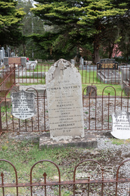
Photograph, Peter Pidgeon, Graves of Thomas Sweeney and family, Eltham Cemetery, Victoria, 5 April 2021
Irish-born Thomas Sweeney is regarded as the first settler in Eltham. He was transported to Sydney in 1823 after being convicted of arson. He was granted his freedom in 1838 and married Margaret Meehan in the same year. They moved to Melbourne and in 1842 Thomas purchased 110 acres beside the Yarra River in the vicinity of present-day Sweeneys Lane. He called the property ‘Culla Hill’ and built a small slab hut (reputedly with Wurundjeri help; Margaret is said to have run an informal hospital for them in return). This was followed in 1846 by more substantial buildings consisting of a three-roomed Irish-style ‘longhouse’ and a barn made of stone and handmade bricks, with doors large enough to accommodate a fully loaded wagon. When the gold rush came, Thomas prospered by selling meat and potatoes to the prospectors, enabling him to purchase a further 308 acres in 1856. He promoted the construction of a bridge over the Plenty River and the establishment of a school at Eltham. Roman Catholic Church services were held at Culla Hill in the early years. When he died in 1867, he was regarded as a respected member of the community. Thomas and Margaret are buried in Eltham Cemetery with many of their descendants. Their first son John continued to farm Culla Hill until his death in 1909. Culla Hill passed out of the Sweeneys' possession in 1939. The house and barn remain today, though lesser outbuildings have gone. The facade of the house is much the same as it was in the 1840s. Sacred To the memory of Thomas Sweeney Who died Sep 6th 1867 Aged 65 years May his soul res in peace Also his wife Margaret Died Oct 3rd 1884 aged 73 years And their daughters Annie Died Aug 22nd 1860 aged 21 years Johanna Died Aug 19th 1872 aged 22 years Margaret Died 7th Sep 1913 aged 72 years R.I.P. Also In Memory Of John Sweeney Died 24th May 1909 Aged 65 years Also of his wife Ellen Died 8th March 1910 Aged 64 years R.I.P Also In Memory Of Caroline Infant daughter of John & Ellen SweeneyBorn Digitalannie sweeney, eltham cemetery, gravestones, johanna sweeney, john murray, margaret sweeney, mary ellen drain, mary murray, thomas drain, thomas sweeney -
 Eltham District Historical Society Inc
Photograph, Peter Pidgeon, Grave of George and Mary Knapman. Eltham Cemetery, Victoria, 5 April 2021
George Knapman was born c.1851 in Ashburton, Devon, England, the son of George Knapman and Elizabeth Grant nee Wyatt. George, his mother and three sisters arrived in the Port of Melbourne, 28 Jul 1857 aboard the ship, Mindoro from Plymouth, his father having preceded them some eighteen months earlier. George married Mary Jane Williams in 1877 and they settled in Eltham where they had five children; Percival George (1878), Florence Maud (1880), Laura Blanche (1882), Alfred Edgar (1886) and Gladys Victoria (1897). In 1879 George was elected a vestryman for St Margaret’s Church, a position he would be re-elected to for many years. Both he and Mary were active members of the church and social activities. In 1884 George was also engaged in collecting funds for the renovation of the St Helena church George was also a member of the Eltham Cricket Club. In May 1884 following completion of the cricket season, several players banded together to form a group holding fortnightly meetings for the purpose of giving readings, recitations, etc to relieve the dullness of the long winter evenings. Charles Wingrove was elected President, Rev. J.B. Gason Treasurer and George along with Messrs Evans, Bourke, D. McColl, C. Jarrold, George Hill and William Brown, members of the Committee. In 1885, George advertised two horses had strayed from his premises (reward £2) and in 1891 he had a cultivator for sale (price £7/10/-). In 1902 he was treasurer of the Eltham Rifle Club. His children attended Eltham Primary School. In 1904 he was a member of the school's Board of Advice and addressed children at an Arbor Day planting activity. In 1907 he was elected president of the Eltham Progressive League, calling for public toilets to be erected at a local picnic spot. George along with William John Taylor and Isaac Hill was also appointed a Trustee of the Eltham Rechabite Hall in Henry Street on behalf of the Hope of Eltham Tent No. 195 Victoria District Independent Order of Rechabites from December 1901 until its sale to the community in December 1921 for use as a public hall. George ‘Snowy’ Knapman was a blacksmith by trade. He owned and operated a shoeing forge and wheelwright workshop, known as Snowy Knapman’s Forge, in Main Road Eltham, next door to the Eltham Court House. The location was well chosen. Mail coaches from Melbourne passed through Eltham enroute to Christmas Hills and Yarra Glen, with another heading to Kingstown (now Panton Hill). It was common practice for horses to be changed at Eltham. Two photos taken June 4, 1907, captioned ‘Election Day Eltham’, show a large crowd of men assembled in Main Road outside Knapman's premises. They are waiting to vote at the Court House. There are no women in the crowd; they were not empowered to vote. George's brothers William and John were also blacksmiths at Heidelberg, continuing the business established by their father George, who had died in 1900. After William died in 1909, George moved to Heidelberg to take over from him. George died at his residence, ‘Devon’, Yarra Street, Heidelberg on March 16, 1923, and is buried in Eltham Cemetery with his wife Mary who died July 16, 1935, at Kew. Their former house at Eltham was located near where the WW1 Monument was erected in 1919, after they had moved to Heidelberg, at the corner of Bridge Street and Main Road and occupied by Mr. R. Trevena at the time of Mary’s death. Mary was sister to E.J. Williams, W. Williams and Mrs Fawkner, all residents of Eltham. In Loving Memory of George Knapman Died 15th March 1923 Also his wife Mary Jane Died 16th July 1935 Sadly Missed Born Digitaleltham cemetery, gravestones, george knapman, mary jane knapman (nee williams) -
 Eltham District Historical Society Inc
Photograph, Peter Pidgeon, Grave of Janet and William Morris, Eltham Cemetery, Victoria, 5 April 2021
William Morris was born in Eltham in 1848 or 1849. He was married three times; his second wife had the same surname as his first so they may have been sisters. He was described as "jolly and hearty" and ran a publican's booth at the Eltham Races in 1903, reportedly doing a good trade. He was an Eltham Shire Councillor between 1897 and 1918 and was Shire President in 1911. The Evelyn Hotel was situated in Main Road Eltham, immediately opposite its competitor the Eltham Hotel. It had opened as the Fountain of Friendship Hotel by 1854, when it was described as having "twelve spacious apartments all canvassed and papered", but had changed its name by 1878. The proprietor from about 1889 until 1919 was William Morris; he was also the licensee for most of that time. (The William Morris who was a butcher at Eltham in the early 1900s was no relation.) It advertised that it had "good stables", located behind the hotel in Pitt Street, a necessity for hotels at the time. Mail coaches en route from Heidelberg to Queenstown (now St Andrews), Panton Hill and Kangaroo Ground changed horses there. It was de-licensed as a hotel in 1919 but continued to operate as a boarding house until it was destroyed by fire in 1931. William died in 1922 and is buried in Eltham Cemetery with several other family members. Janet The Beloved Wife of William Morris Who died 5th October 1880 Aged 24 years Also Alfred George Morris Died 11th September 1880, aged 1 year Also William Morris Died 8th December 1922 Aged 74 years At RestBorn Digitaleltham cemetery, gravestones, alfred george morris, evelyn hotel, janet morris, william morris -
 Eltham District Historical Society Inc
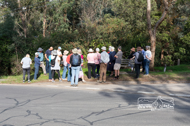
Photograph, Peter Pidgeon, Heritage Excursion: Mud Brick Meander, 6 March 2021
Corner of Diamond Street and Peter Street, Eltham. Walkers gather for the beginning of the walk led by local historian Russell Yeoman. The tree-covered hill that forms the western backdrop to the Eltham town centre exhibits many characteristics that are considered to contribute to the special character of Eltham. They include unmade streets, steeply sloping land, extensive tree cover and a large number of mud brick and pise (rammed earth) houses. A number of these were constructed in the 1940s and 50s by well-known builders John Harcourt and Alistair Knox. A significant proportion from this period were constructed by owner-builders. We walked around the upper part of the hill in the area of Kerrie Crescent and Peter Street. We visited several interesting houses (for external viewing only). The walk commenced at 2pm at the corner of Diamond Street and Peter Street (Melway ref 21H4) and was about 2 km. This free walk was open to the general public as well as Society members. Whilst COVID restrictions did not require the wearing of masks in the open, masks had to be carried and all attendees registered with name and contact number or via QR registration.Born Digital (8 images)covid-19, eltham, eltham district historical society, heritage excursion, mudbrick, peter street, diamond street, russell yeoman -
 Eltham District Historical Society Inc
Document - Series Listing, Fraser Faithfull et al, Series 17: Murphy's House, Panton Hill, 18 colour photographs, 2000
... Series 17: Murphy's House, Panton Hill, 18 colour... Series 17: Murphy's House, Panton Hill, 18 colour photographs ...Series consists of 18 colour photographs of the interior and exterior of Murphy's House, a property purchased by Eltham Shire for community use.shire of eltham archives, series listing -
 Eltham District Historical Society Inc
Document - Series Listing, Fraser Faithfull et al, Series 18: Murphy's House, Panton Hill, 20 colour negatives, 2000
... Series 18: Murphy's House, Panton Hill, 20 colour negatives... Series 18: Murphy's House, Panton Hill, 20 colour negatives ...Series consists of 20 colour negatives of the interior and exterior of Murphy's House, a property purchased by Eltham Shire for community use.shire of eltham archives, series listing -
 Eltham District Historical Society Inc
Photograph, Fay Bridge, Clifton Pugh's Artists' Colony, Dunmoochin, Barreenong Road, Cottles Bridge, c.1995
Visit to Dunmoochin prior to Clifton Pugh's home being destroyed by fire in 2002. Following military service in the second world war, Clifton Pugh studied under artist Sir William Dargie at the National Gallery School in Melbourne as well as Justus Jorgensen, founder of Montsalvat. For a while he lived on the dole but also worked packing eggs for the Belot family saving sufficient to purchase six acres (2.4 ha) of land at Barreenong Road, Cottles Bridge. He accumulated more land and persuaded several other artists and friends to buy land nearby, resulting in a property of approximately 200 acres, stablishing it as one of the first artistic communes in Australia alongside Montsalvat in Eltham. It was around 1951 that Pugh felt he had '"done moochin' around" and so the name of the property evolved. He bought timber from Alistair Knox to build his house on the crest of a hill. Inspired by local goldminer's huts, it was a one room wattle-and-daub structure with dirt floor. Over the years it expanded with thick adobe walls made from local clay, high ceilings and stone floors. All materials other than the local earth were sourced from second hand materials, most found at wreckers' yards. Artists from across the nation were drawn to Dunmoochin, with several setting up houses and shacks on the property, maintaining their independence but sharing their artistic zeal. Artists who worked or resided at Dunmoochin included Mirka Mora, John Perceval, Albert Tucker, Fred Williams, Charles Blackman, Arthur Boyd and John Olsen. In 2002, Pugh's house along with its treasure trove of art and a library of some 20,000 books was destroyed by fire. Traces of Pugh's home remain with the presence of the Victorian doorframe archway with leadlight of intricate design, procured from a demolished Melbourne mansion; and two bronze life-sized female statues created by Pugh and cast by Matcham Skipper. In place of Pugh's house rose two double-storey mud-brick artists' studios topped with corrugated iron rooves curved like the wings of a bird with accommodation for seven. The original studios, gallery and other buildings survived the fire.fay bridge collection, 1995, barreenong road, cottles bridge, dunmoochin -
 Eltham District Historical Society Inc
Photograph, Fay Bridge, Clifton Pugh's Artists' Colony, Dunmoochin, Barreenong Road, Cottles Bridge, 14 May 2016
Following military service in the second world war, Clifton Pugh studied under artist Sir William Dargie at the National Gallery School in Melbourne as well as Justus Jorgensen, founder of Montsalvat. For a while he lived on the dole but also worked packing eggs for the Belot family saving sufficient to purchase six acres (2.4 ha) of land at Barreenong Road, Cottles Bridge. He accumulated more land and persuaded several other artists and friends to buy land nearby, resulting in a property of approximately 200 acres, stablishing it as one of the first artistic communes in Australia alongside Montsalvat in Eltham. It was around 1951 that Pugh felt he had '"done moochin' around" and so the name of the property evolved. He bought timber from Alistair Knox to build his house on the crest of a hill. Inspired by local goldminer's huts, it was a one room wattle-and-daub structure with dirt floor. Over the years it expanded with thick adobe walls made from local clay, high ceilings and stone floors. All materials other than the local earth were sourced from second hand materials, most found at wreckers' yards. Artists from across the nation were drawn to Dunmoochin, with several setting up houses and shacks on the property, maintaining their independence but sharing their artistic zeal. Artists who worked or resided at Dunmoochin included Mirka Mora, John Perceval, Albert Tucker, Fred Williams, Charles Blackman, Arthur Boyd and John Olsen. In 2002, Pugh's house along with its treasure trove of art and a library of some 20,000 books was destroyed by fire. Traces of Pugh's home remain with the presence of the Victorian doorframe archway with leadlight of intricate design, procured from a demolished Melbourne mansion; and two bronze life-sized female statues created by Pugh and cast by Matcham Skipper. In place of Pugh's house rose two double-storey mud-brick artists' studios topped with corrugated iron rooves curved like the wings of a bird with accommodation for seven. The original studios, gallery and other buildings survived the fire.fay bridge collection, 2016-05-14, art gallery, barreenong road, clifton pugh, cottles bridge, dunmoochin, maurice hurry -
 Eltham District Historical Society Inc
Photograph, Fay Bridge, Former Glynn's Dairy Farm, Glynns Road, North Warrandyte, 31 August 2018
Glynn’s farm Originally Section 7, Parish of Nillumbik marked Aborigine Reserve in 1866 Crown Allotment 8, Section 7, Parish of Nillumbik, County of Evelyn, Certificate of Title Volume 4095, Folio 818.835, approx. 93 acres purchased by Joseph Panton in 1881 for £1/acre and known as Panton’s Point. By 1924 owned by S.S. Sergeant and called Riverswood. Sergeant commissioned Edna Walling to design the garden. In September 1929 the property was sold at auction by Mortgagee’s sale. Described as well built, brick, tile roof, Attic Villa containing downstairs 7 good rooms, bath, scullery, inside lavatory, etc. Upstairs 2 bedrooms and sleep out. Outbuildings compromising of brick and weatherboard wash house, stables, workshop, feed room, cow bails, large G.I. Hay shed, etc In January 1931 Riverswood property was proclaimed a sanctuary for native game for the entire year. A private swing bridge crossed the river at Pound Bend was known as Pearson’s bridge after C.W.K. Pearson who bought Riverswood in the early 1930s. The bridge was swept away in the December 1934 floods. Riverswood was sold by C.W.K. Pearson at auction on 25 November 1936. Described as a beautiful farm home of 93 acres and over one mile of River Yarra frontage, modern brick residence, lovely garden, rich river flat pastures, model poultry farm. The fine brick home was destroyed on Black Friday (13 Jan.) 1939. It was still a ruin when the Evelyn Evans purchased Waikowhane above Riverswood in 1940. The Glynn family purchased the Riverswood property in 1941 from Robert and Emily Hannon. Their son Kenneth Patrick Glynn inherited the property and he set about clearing the land during WW2 selling wood. Prior to marriage, Kenneth was living alone on the farm in a house he had built from whatever was available. He used the bluestone foundations from the original fine brick home. He met and married Honora Elizabeth Drew in early 1945 and their daughter Anna grew up on the farm. It was compulsorily acquired by the Board of Works in 1976 who then rented the house out in the 1980s. The property was transferred to Melbourne Parks and Waterways in 1996. Waikowhane was a pretty timber house built on top of the hill on 50 acres above Riverswood by retired nurse Jessie MacBeth. (This would be at the intersection of Glynns Road and Overbank Road where the big water tank is now situated on what was once James Orford’s property.) It was also destroyed Black Friday and she rebuilt it from the plans living in a caravan on site supervising the build. It was almost complete when she died May 1939. The property was bought by Evelyn Evans (a city girl) and her estranged husband in 1940. She had two sons, one only 9 months old at the time. It was a timber house with no power or water connected. The Ewen Cameron family bought Waikowhane in 1957. They had to evacuate when the 1961 bushfires swept through. The house was saved by Matcham Skipper. It was demolished by Melbourne Water in the 1990s when they acquired it.fay bridge collection, 2018-08-31, glynn's, glynn's dairy farm, glynns road, north warrandyte, parks victoria, ruins, riverswood, kenneth patrick glynn -
 Eltham District Historical Society Inc
Photograph, Peter Pidgeon, Grave of Janet and William Morris, Eltham Cemetery, Victoria, 5 Oct 2022
William Morris was born in Eltham in 1848 or 1849. He was married three times; his second wife had the same surname as his first so they may have been sisters. He was described as "jolly and hearty" and ran a publican's booth at the Eltham Races in 1903, reportedly doing a good trade. He was an Eltham Shire Councillor between 1897 and 1918 and was Shire President in 1911. The Evelyn Hotel was situated in Main Road Eltham, immediately opposite its competitor the Eltham Hotel. It had opened as the Fountain of Friendship Hotel by 1854, when it was described as having "twelve spacious apartments all canvassed and papered", but had changed its name by 1878. The proprietor from about 1889 until 1919 was William Morris; he was also the licensee for most of that time. (The William Morris who was a butcher at Eltham in the early 1900s was no relation.) It advertised that it had "good stables", located behind the hotel in Pitt Street, a necessity for hotels at the time. Mail coaches en route from Heidelberg to Queenstown (now St Andrews), Panton Hill and Kangaroo Ground changed horses there. It was de-licensed as a hotel in 1919 but continued to operate as a boarding house until it was destroyed by fire in 1931. William died in 1922 and is buried in Eltham Cemetery with several other family members. Janet The Beloved Wife of William Morris Who died 5th October 1880 Aged 24 years Also Alfred George Morris Died 11th September 1880, aged 1 year Also William Morris Died 8th December 1922 Aged 74 years At RestBorn Digitaleltham cemetery, gravestones, alfred george morris, evelyn hotel, janet morris, william morris -
 Eltham District Historical Society Inc
Document - Property Binder, 836 Main Road, Eltham
Newspaper article: Was woman found in well put in it? Diamond Valley Local, 16 February 1954, story of wife of baker found in well before Burgoyne family purchased bakery. Newspaper article: Bakery goes ... locals protest, The Valley Voice, 18 July 1979, Joh Ebeli protests about planned destruction, history of building memories of Alistair Knox. Note on demolition of Eltham Bakery building, 1979, by Joh Ebeli who tried to save front of house with friend names Elwers. Photocopy newspaper article: Murder mystery at bakery, History comes to life for old building, 4 November 1979, Harry Burgoyne remembers his grandfather John James Thomas Neville Burgoyne bought bakery in 1896 at time of body found in well, bakery build 1860-1864, sold in 1921. Photocopy newspaper article: Public meeting called over Eltham restaurant proposal, Diamond Valley News, 4 October 1988, protests re proposal for motel and restaurant. Photocopy newspaper article: Fresh tales at an old mine, Diamond Valley News, 4 October 1988, Ausminde Pty Ltd applied for renewal of exploration licence at Old Tree Hill Mine, last mined by Stan Bone and Bill Wallace, photograph of Russell Yeoman at site. Photocopy of line drawing, The Bakery, by Joh Ebeli, 1978. Photocopy of photograph, Old Bakery, next to house built 1880. Photocopy of photograph with Old Bakery in background. On August 12, 1902, appearing before T. Smallman, Esq,. Police Magistrate, and Messrs. W. Duncan and W.J. Taylor, Justices of the Peace is Luther Haley, baker. Wilfred Henry Johnston, by his agent Stanley Ernest Elder had applied for a warrant of ejectment under the Landlord and Tenant Act 1890 against Luther Haley from the bakery premises at the corner of Main Road and York Street. From the evidence presented it is made known that Mrs Burgoyne of Eltham had purchased the property some months earlier from Mr Johnston, which consisted of a store and bakery establishment at Eltham occupied by Mr. Luther Haley, and whose lease expired some little time back, and up to the present time, Mr. Haley was not prepared to leave. He informed the court that he was unable to secure at Eltham a suitable house in which to carry on his business, but he was building a place near the railway station which he expected to be done in about three weeks time, at which time he would give up possession of the bakery. Mr Smallman informed the defendant, Luther Haley, that he would have to quit the premises in three weeks from the present date, and that a warrant of ejectment would be issued. However he also informed Mr Haley that he would order the warrant to lie in the office for three weeks from that date. The premises under construction refered to by Luther Haley in court were situated on the western side of Main Road, near the railway station slightly opposite present day Arthur Street. It was opened around September 1902 as a General Store, Bakery and Tea Rooms. In June 2024 Annie Hackrath shared a memory of living in the old bakery: "My husband and I lived in the old bakery for 18 months in 1978-9 , husband Geoff used the old bakery out the back as a wood workshop, making turnery and handcrafted furniture. The front shop was operated as a “sometimes” art gallery which we called “Gouge and Grain”. There were old sheds against the back fence which we thought were probably stables from the bakery days. Lovely memories of the old place which had so much character and seemed to attract a multitude of interesting creative people! Sad that it was pulled down; a friend salvaged some of the lead light glass in the old doors and included it in a new door panel for us."main road, eltham, property, shops, businesses, eltham bakery, burgoyne family, joh ebeli, alistair knox, harry burgoyne, john james thomas neville burgoyne, one tree hill mine, stan bone miner, bill wallace miner, russell yeoman, henry rech, ausminde pty ltd, john street, bridge street, judy paynter, art gallery, gouge and grain, annie hackrath, geoff hackrath -
 Eltham District Historical Society Inc
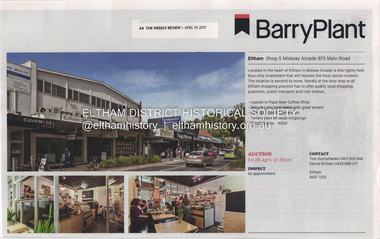
Document - Property Binder, 972 Main Road, Eltham
Newspaper advertisement: the Weekly Review 19 April 2017, Barry Plant real estate. Newspaper clipping: Arts and Crafts in Midway Arcade, Susan Foreman, Manningham & Nillumbik Bulletin, November 2023, p17main road, eltham, property, houses, shops, businesses, barry plant real estate, 45/123 main road eltham, 141 karingal drive briar hill, midway arcade, cathy oliver, galleries, pardalote collections -
 Eltham District Historical Society Inc
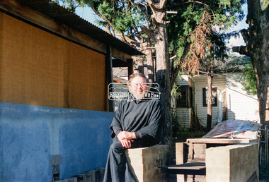
Negative - Photograph, Eltham Shire Council, Possibly a non-compliant house in Simms Road, Kinglake, c.1989
Facebook comments suggested this location may be a cabinetmaker by the name of Cook out the back of Panton Hill. Another comment recalled this man as a visitor to Montsalvat as a friend of the late poet, Geoffrey Egglestone. It is believed his name is Mizza. He is a Bohemium Poet. Also a frequent visitor to the St Andrews market. Photos taken by Eltham Shire Council officers most likely during an inspection of the property for non compliance. Other images on the roll of film are of Council Health officers undergoing food inspections at the shops, maternal health services and housing estate development inspectionsRoll of 35mm colour negative film, 6 strips Frames 3 through 9Fuji 100eltham shire council, shire of eltham, 1989, atlantic ethyl, sheds, signs, unidentified, houses, kinglake, simms road -
 Eltham District Historical Society Inc
Slide - Photograph, Unidentified property, possibly at Garden Hill Kangaroo Ground, c.1970
35mm colour positive transparency Mount - Agfacolor Service (Blue)houses, kangaroo ground, unidentified -
 Eltham District Historical Society Inc
Slide - Photograph, Unidentified property, possibly at Garden Hill Kangaroo Ground, c.1970
35mm colour positive transparency Mount - Agfacolor Service (Blue)houses, kangaroo ground, unidentified -
 Eltham District Historical Society Inc
Document, Samantha Westbrooke Pty Ltd et al, 2 Bell Street, Eltham: Cultural Heritage Significance Assessment & Heritage Guidelines for Future Use & Development, 2012
Prepared for Nillumbik Shire Council by Samantha Westbrooke Pty Ltd in association with Peter Mills PhD, Architectural Historian and Roark Muhlen-Schilte, Archaeologist. Covers history of early market gardening in Eltham with the commencement of European settlement in the late 1830s. The site for the village of Eltham was surveyed in 1851 and the Township Plan shows that the property is made up of Lots 7 and 8 which were sold at auction in June 1852 to M. O'Shea. The history of the Bell Street property is closely tied to the West family from the 1860s to 1930s; the earliest rate books for Eltham show William West farming in El;tham in 1864. In the aerly 1930s ownership of the creek side was transferred from the west family to the Fabbro family who shortly afterwards were impaced by the 1934 Diamond Creek flooding. Guido Fabbro relocated the original West home further up the hill and built a new Italianate style modern home in situ. The Fabbro family farmed the property. In 1993/4 Eltham Council acquired the creek-side market garden blocks to the south of 2 Bell Street which was recconceived in 1998 as the Barak Bushland Reserve. The Fabbro house was demolished shortly after and the lots were sold to a developer in 1994. The large steel shed now present on the 2 Bell Street property dates from soon after this sale.26 A4 pages color printcultural heritage significance assessment, peter mills, samantha westbrooke pty ltd, shire of nillumbik, 2 bell street, eltham, market gardening, west family, fabbro family, land use, barak bushland reserve, heritage assessment -
 Eltham District Historical Society Inc
Photograph - Aerial Photograph, Landata, Eltham, Main Road; Mt Pleasant Rd to Railway Rd, Dec. 1945
Centred on Main Rd and Henry St, Eltham bounded by Railway Road to north, Mount Pleasant Road at Main Road to south, top of the hill in Arthur Street to east and Karingal Drive at Sherbourne Road to west. Historic Aerial Imagery Source: Landata.vic.gov.au Aerial Photo Details: Project No :65 Project : MELBOURNE AND METROPOLITAN PROJECT NO. 2 Run : 8 Frame : 70 Date : 01/1951 Film Type : B/W Camera : EAG9 Flying Height : 12200 Scale : 12000 Film Number : 1419 GDA2020 : 37°43'06"S, 145°08'45"E MGA2020 : 336589, 5823811 (55) Melways : 21 J6 (ed. 42)aerial photo, eltham, main road, henry street, arthur street, bolton street, eltham-yarra glen road, neil webster collection, 1951-01, dave lyon house, ernie andrew house, karingal road, melway 21j6, mount pleasant road, railway road -
 Eltham District Historical Society Inc
Photograph - Aerial Photograph, Landata, Eltham; Crown Allotment 15, Section 5, Parish of Nillumbik (Stokes Orchard Estate), Dec. 1945
Centred on present day Diosma Rd, Stokes Pl, Nyora Rd and Eucalyptus Rd Historic Aerial Imagery Source: Landata.vic.gov.au Aerial Photo Details: Project No :5 Project : MELBOURNE AND METROPOLITAN AREA PROJECT Run : 36 Frame : 60546 Date : 12/1945 Film Type : B/W Camera : EAG4 Flying Height : 10200 Scale : 6000 Film Number : 195 GDA2020 : 37°42'47"S, 145°09'56"E MGA2020 : 338306, 5824438 (55) Melways : 22 C4 (ed. 42) A History of the Development of Crown Allotment 15, Section 5, Parish of Nillumbik – Stokes Orchard Crown Allotment 15, Section 5, Parish of Nillumbik (CA15) is a square allotment of 158 acres or approximately a quarter of a square mile. It lies just beyond the eastern end of Pitt Street, south of Nyora Road to the northern end of Eucalyptus Road and extends east from Eucalyptus Road to Reynolds Road. The topography of CA15 is generally steep, sloping up to a hill near the centre of the land, the ridgeline passing through the properties along the southern side of Diosma Road. Eucalyptus Road is a straight north-south road with its northern end at the north west corner of CA15. Until the end of the 1970s this road was an un-named Government Road and was largely not open to traffic. With residential development in the 1970s the road was constructed, and the council allocated the name obviously in recognition of the predominant species of the local bushland. CA15 was purchased from the Crown by George D’Arley Boursiquot, a prominent Melbourne printer, on 28th October 1852. On November 23, 1922, former Member for Gippsland and Melbourne Real Estate Agent, Hubert Patrick Keogh purchased the allotment then sold it March 13, 1925, to local farmer, Robert David Taylor, a former Shire of Eltham Councillor (1911-1920) and Shire President (1919). Taylor had extensive land holdings stretching west towards Bible Street and Main Road. The Taylor home was situated at the top of the hill in Bible Street at present day 82 Bible Street. At the time of Taylor’s purchase in 1925, CA15 was subdivided into 48 lots that could be described as small rural properties or large residential lots. A typical lot size was one hectare or 2.5 acres. The subdivision created two roads, Nyora Road, and Diosma Road, each following an irregular alignment between Eucalyptus and Reynolds Roads. However, the lots were not sold off separately nor were the roads constructed. The land effectively remained as one parcel for many further years. Robert David Taylor died November 30, 1934, and probate was granted to his son of the same name, Robert David Taylor of Bible Street, Salesman and William McLelland Vance Taylor of 73 Emmeline Street, Northcote, Clerk, with the transfer of the land into their names on July 8, 1935. Frank Stokes worked as a qualified accountant at Kennons leather factory in Burnley, while living at 1 Thomas Street, Mitcham. He suffered from migraines and wanted to return to working the land (he had previously worked on farms and orchards since coming to Australia from England in 1926, both in WA and Vic.). He first travelled to the district by train in July 1942 to find land with the intention to establish an orchard. By chance he met Arthur Bird of Bird Orchard (bounded by Pitt Street, Eucalyptus Road, and Wattle Grove) and they got talking over their common interest. Arthur put Frank up for the night and pointed out the land, 158 acres- part of the Taylor Estate- £900, Crown Allotment 15, Section 5, Parish of Nillumbik (CA15) somewhat diagonally opposite Bird Orchard. Stokes applied through the Riverina Agency to purchase the land who in turn applied for permission from Canberra to sell as there was a new government regulation introduced during the Second World War banning land sales except for immediate production. Stokes obtained a loan on his Mitcham house of £600 @ 5% and paid £450 deposit with quarterly payments of £15 spread over 5 years. Stokes was assisted and advised by Arthur Bird who farmed the neighbouring orchard. In early 1943 Stokes took possession and would catch the train out to Eltham on Fridays after work and began building a hut on the corner of Nyora Road and the Government Road (Eucalyptus Road) for shelter and to lock up tools. He established an orchard on the central western part of the land through the centre of which ran a natural waterway (part of the present-day linear park) and was able to pay a neighbour (Hawkins) to help with clearing and fencing 25 acres, and with a horse and single furrowed plough, planted approximately 2,500 fruit trees - cherries, peaches, plums, almonds, pears, apricots and lemons as well as a few apples and oranges; a massive task. Aerial photographs from the 1940s through to the 1990s clearly show the orchard with most of the larger CA15 site remaining as natural bushland. A huge problem was hares and rabbits eating all the new buds off the tiny trees. As well as laying poison he painted the trees with a mixture of cow manure and lime, often working by moonlight. Procurement of wire and wire netting was difficult because of the war but after much effort he obtained a permit from the Agricultural Department for supplies in March 1944. In February 1945 Stokes applied for a permit to build a “packing shed” as no house building was allowed. It was to be 33 feet x 21 feet and cost £312. It was constructed mostly from second-hand materials, which were hard to obtain, especially iron for roofing. Stokes finished work at Kennons on October 31, 1945, and in March 1946 he sold the family home at Mitcham for £1,230 plus £170 for furniture. On May 15, 1946, title to the CA15 property was issued to Frank Howard Alfred Stokes, Orchardist and Gladys Ethel Stokes, Married Woman, both of Pitt Street, Eltham. The family of five then moved into the very unfinished “packing shed” at Eltham, which was a struggle to weatherproof. Eventually rooms were divided off and lined with hessian bags and whitewashed. Their income was firewood (cut and sold), selling rockery stones and cut Sweet Bursaria. (It was discovered during the 1940s that Sweet Bursaria contained the sunscreen compound Aesculin. The RAAF utilised this compound from Sweet Bursaria during WW2 for pilots and gunners.) The orchard’s first fruit sale was a half-case of Le Vanq peaches in December 1947 for the price of 8 shillings. In 1956 plans for house were drawn and Glen Iris bricks purchased (1956 Olympic Rings variant). The building of the house commenced in 1957 - 12 feet of original packing shed was removed – and was completed in 1959. Water was connected from newly built pressure storage on the property at the end of 1959 and the electricity connection for the first time at 3pm on April 29, 1960. The house remains to present day (somewhat modified) at 1 Nyora Road, home to Nyora Studio Gallery. On occasions, spare remnants of the 1956 bricks have been known to be unearthed in gardens on the estate as they were utilised by Frank Stokes to fill in rabbit holes. On May 26, 1950, a parcel of land was compulsorily acquired by the Melbourne and Metropolitan Board of Works on the hilltop to establish an easement for a high-level service reservoir to augment Eltham’s water supply. The project also included pipe tracks for the necessary water mains. The reservoir has now been superseded by higher level water tanks east of Reynolds Road and its former site is now a public reserve. On November 27, 1964, the State Electricity Commission served notice to compulsorily acquire a further parcel through the eastern part of the land for a major electricity transmission line that augmented supply from the La Trobe Valley to Melbourne. The easement was registered February 11, 1966. The easement was widened July 18, 1969 for a second transmission line to be constructed. In 1971 Melbourne Metropolitan Planning Scheme amendments adopted Nyora Road as the boundary between a residential zone to the north and a rural zone to the south. This determined the future development of the land. In the mid-1970s the Shire of Eltham divided the orchard into numerous rate-able parcel lots, the 48 lots having been established in 1925 and the subsequent rates assessment proved unsustainable for Stokes. He commenced selling lots outside the boundary of the orchard, north of Diosma and South of Nyora. However shortly later the land between Nyora and Diosma Roads and west of the electricity easement was sold and subdivided into residential lots, a housing development by Macquarie Builders and marketed as the Stokes Orchard Estate. New streets were created, and most were named after trees, although one, Stokes Place, commemorates the former owners. The development was undertaken in two stages; Stage 1 (1975) encompassing Scarlet Ash Court, Ironbark Close and Peppermint Grove bounded by Nyora and Eucalyptus roads and Stage 2 (1978) encompassing Stokes Place, Orchard Way, The Crest and The Lookout bound by Nyora and Diosma roads. The developer, Macquarie Builders went bankrupt shortly after the release of Stage 2 leaving many purchasers to fend for themselves and arrange for their own independent builders. There were also difficulties with sewerage for the land immediately south of Diosma Road and so the conventional residential lots were abandoned in favour of larger lots. The development of Orchard Way, The Crest and The Lookout did not proceed as planned and the proposed lots were incorporated into five-acre parcels instead. These included a low-density group housing development by the Graves family and the award winning Choong House (1983) with Gordon Ford developed garden immediately next door situated on the ridge of the hill nestled amongst the original bush, Eucalypt trees and Sweet Bursaria. In 1994, Nillumbik Shire Council applied Significant Environment and Significant Landscape overlays upon the properties on the south side of Diosma Road to ensure protection of this natural bush garden environment. With the arrival of the sewer along Diosma Road in the 1990s, most of these five-acre parcels have since been subdivided multiple times. The Choong house presently sits on a 2.7-acre property, which in 2022 Nillumbik Council nominated for Cultural Significance Heritage protection and is considered potentially significant at State level. The Stokes family were also associated with the Eltham Christian Church. In the 1970s this church had met in temporary premises in Eltham. Lots of the original 1925 subdivision remained south of Nyora Road and a number of these lots were utilized for the Eltham Christian School, which was established by the Eltham Christian Church in 1981. The school operated on this site until 2000. The premises are now used by The Vine Baptist Church. By the mid-1980s the whole of CA15 had been developed for residential and school purposes, except for the sections north of Diosma Road and between the transmission lines and Reynolds Road. Sewerage issues had been resolved for the section north of Diosma Road and in 1987 it was in the process of being subdivided into residential lots. The development coincided with the discovery of colonies of the rare and endangered Eltham Copper Butterfly on the site. This resulted in a community and political campaign to save the butterfly habitat. With the co-operation of the land developer the subdivision was altered to create two bushland reserves in the critical butterfly habitat areas. In the late 1980s the State Government was investigating options for establishing a metropolitan ring road link between Diamond Creek and Ringwood. The chosen route was adjacent to Reynolds Road and so this created a freeze on development of CA15 between Reynolds Road and the electricity easement. The ring road proposal was eventually abandoned, and this part of the land was subdivided into low density residential lots. Diosma Road has been discontinued at the electricity easement and the eastern part incorporated into View Mount Court with access from Reynolds Road. The whole of CA15 has now been developed for residential or associated purposes, ranging from conventional density to quite low density south of Nyora Road. Some remnants of the orchard remain, a few cherry trees on the Graves property and a lone apple tree in Stokes Place. The butterfly reserves comprise significant areas of remnant bushland. Linear reserves through the estate link with central Eltham via the Woodridge linear reserve and with Research along the electricity easement. CA15 as it exists today has a complicated history of rural use, Government acquisition, urban development, and community action. References: • “Stokes Orchard, an incomplete history”; Russell Yeoman with Doug Orford • Correspondence, Beryl Bradbury (nee Stokes) • Aerial Photographs, 1931-1991, Landata (landata.vic.gov.au) • Certificate of Title, Vol. 4930 Fol. 985900 • Plan Number LP 10859 aerial photo, diosma road, eltham copper butterfly, eucalyptus road, ironbark close, nyora road, peppermint grove, peter & elizabeth pidgeon collection, power transmission lines, reynolds road, scarlet ash court, stokes orchard estate, stokes place, woodridge estate, frank stokes -
 Eltham District Historical Society Inc
Photograph - Aerial Photograph, Landata, Eltham; Crown Allotment 15, Section 5, Parish of Nillumbik (Stokes Orchard Estate), Nov. 1931
Centred over present day Reynolds Road and Mount Pleasant Road, Eltham (including Diosma Rd, Stokes Pl, Nyora Rd and Eucalyptus Rd) Historic Aerial Imagery Source: Landata.vic.gov.au Aerial Photo Details: Project No :1931 Project : MALDON PRISON Run : 21 Frame : 3160 Date : 11/1931 Film Type : B/W Camera : F8 Flying Height : 11000 Scale : 18860 Film Number : 60 GDA2020 : 37°43'31"S, 145°10'20"E MGA2020 : 338912, 5823086 (55) Melways : 22 E8 (ed. 42) A History of the Development of Crown Allotment 15, Section 5, Parish of Nillumbik – Stokes Orchard Crown Allotment 15, Section 5, Parish of Nillumbik (CA15) is a square allotment of 158 acres or approximately a quarter of a square mile. It lies just beyond the eastern end of Pitt Street, south of Nyora Road to the northern end of Eucalyptus Road and extends east from Eucalyptus Road to Reynolds Road. The topography of CA15 is generally steep, sloping up to a hill near the centre of the land, the ridgeline passing through the properties along the southern side of Diosma Road. Eucalyptus Road is a straight north-south road with its northern end at the north west corner of CA15. Until the end of the 1970s this road was an un-named Government Road and was largely not open to traffic. With residential development in the 1970s the road was constructed, and the council allocated the name obviously in recognition of the predominant species of the local bushland. CA15 was purchased from the Crown by George D’Arley Boursiquot, a prominent Melbourne printer, on 28th October 1852. On November 23, 1922, former Member for Gippsland and Melbourne Real Estate Agent, Hubert Patrick Keogh purchased the allotment then sold it March 13, 1925, to local farmer, Robert David Taylor, a former Shire of Eltham Councillor (1911-1920) and Shire President (1919). Taylor had extensive land holdings stretching west towards Bible Street and Main Road. The Taylor home was situated at the top of the hill in Bible Street at present day 82 Bible Street. At the time of Taylor’s purchase in 1925, CA15 was subdivided into 48 lots that could be described as small rural properties or large residential lots. A typical lot size was one hectare or 2.5 acres. The subdivision created two roads, Nyora Road, and Diosma Road, each following an irregular alignment between Eucalyptus and Reynolds Roads. However, the lots were not sold off separately nor were the roads constructed. The land effectively remained as one parcel for many further years. Robert David Taylor died November 30, 1934, and probate was granted to his son of the same name, Robert David Taylor of Bible Street, Salesman and William McLelland Vance Taylor of 73 Emmeline Street, Northcote, Clerk, with the transfer of the land into their names on July 8, 1935. Frank Stokes worked as a qualified accountant at Kennons leather factory in Burnley, while living at 1 Thomas Street, Mitcham. He suffered from migraines and wanted to return to working the land (he had previously worked on farms and orchards since coming to Australia from England in 1926, both in WA and Vic.). He first travelled to the district by train in July 1942 to find land with the intention to establish an orchard. By chance he met Arthur Bird of Bird Orchard (bounded by Pitt Street, Eucalyptus Road, and Wattle Grove) and they got talking over their common interest. Arthur put Frank up for the night and pointed out the land, 158 acres- part of the Taylor Estate- £900, Crown Allotment 15, Section 5, Parish of Nillumbik (CA15) somewhat diagonally opposite Bird Orchard. Stokes applied through the Riverina Agency to purchase the land who in turn applied for permission from Canberra to sell as there was a new government regulation introduced during the Second World War banning land sales except for immediate production. Stokes obtained a loan on his Mitcham house of £600 @ 5% and paid £450 deposit with quarterly payments of £15 spread over 5 years. Stokes was assisted and advised by Arthur Bird who farmed the neighbouring orchard. In early 1943 Stokes took possession and would catch the train out to Eltham on Fridays after work and began building a hut on the corner of Nyora Road and the Government Road (Eucalyptus Road) for shelter and to lock up tools. He established an orchard on the central western part of the land through the centre of which ran a natural waterway (part of the present-day linear park) and was able to pay a neighbour (Hawkins) to help with clearing and fencing 25 acres, and with a horse and single furrowed plough, planted approximately 2,500 fruit trees - cherries, peaches, plums, almonds, pears, apricots and lemons as well as a few apples and oranges; a massive task. Aerial photographs from the 1940s through to the 1990s clearly show the orchard with most of the larger CA15 site remaining as natural bushland. A huge problem was hares and rabbits eating all the new buds off the tiny trees. As well as laying poison he painted the trees with a mixture of cow manure and lime, often working by moonlight. Procurement of wire and wire netting was difficult because of the war but after much effort he obtained a permit from the Agricultural Department for supplies in March 1944. In February 1945 Stokes applied for a permit to build a “packing shed” as no house building was allowed. It was to be 33 feet x 21 feet and cost £312. It was constructed mostly from second-hand materials, which were hard to obtain, especially iron for roofing. Stokes finished work at Kennons on October 31, 1945, and in March 1946 he sold the family home at Mitcham for £1,230 plus £170 for furniture. On May 15, 1946, title to the CA15 property was issued to Frank Howard Alfred Stokes, Orchardist and Gladys Ethel Stokes, Married Woman, both of Pitt Street, Eltham. The family of five then moved into the very unfinished “packing shed” at Eltham, which was a struggle to weatherproof. Eventually rooms were divided off and lined with hessian bags and whitewashed. Their income was firewood (cut and sold), selling rockery stones and cut Sweet Bursaria. (It was discovered during the 1940s that Sweet Bursaria contained the sunscreen compound Aesculin. The RAAF utilised this compound from Sweet Bursaria during WW2 for pilots and gunners.) The orchard’s first fruit sale was a half-case of Le Vanq peaches in December 1947 for the price of 8 shillings. In 1956 plans for house were drawn and Glen Iris bricks purchased (1956 Olympic Rings variant). The building of the house commenced in 1957 - 12 feet of original packing shed was removed – and was completed in 1959. Water was connected from newly built pressure storage on the property at the end of 1959 and the electricity connection for the first time at 3pm on April 29, 1960. The house remains to present day (somewhat modified) at 1 Nyora Road, home to Nyora Studio Gallery. On occasions, spare remnants of the 1956 bricks have been known to be unearthed in gardens on the estate as they were utilised by Frank Stokes to fill in rabbit holes. On May 26, 1950, a parcel of land was compulsorily acquired by the Melbourne and Metropolitan Board of Works on the hilltop to establish an easement for a high-level service reservoir to augment Eltham’s water supply. The project also included pipe tracks for the necessary water mains. The reservoir has now been superseded by higher level water tanks east of Reynolds Road and its former site is now a public reserve. On November 27, 1964, the State Electricity Commission served notice to compulsorily acquire a further parcel through the eastern part of the land for a major electricity transmission line that augmented supply from the La Trobe Valley to Melbourne. The easement was registered February 11, 1966. The easement was widened July 18, 1969 for a second transmission line to be constructed. In 1971 Melbourne Metropolitan Planning Scheme amendments adopted Nyora Road as the boundary between a residential zone to the north and a rural zone to the south. This determined the future development of the land. In the mid-1970s the Shire of Eltham divided the orchard into numerous rate-able parcel lots, the 48 lots having been established in 1925 and the subsequent rates assessment proved unsustainable for Stokes. He commenced selling lots outside the boundary of the orchard, north of Diosma and South of Nyora. However shortly later the land between Nyora and Diosma Roads and west of the electricity easement was sold and subdivided into residential lots, a housing development by Macquarie Builders and marketed as the Stokes Orchard Estate. New streets were created, and most were named after trees, although one, Stokes Place, commemorates the former owners. The development was undertaken in two stages; Stage 1 (1975) encompassing Scarlet Ash Court, Ironbark Close and Peppermint Grove bounded by Nyora and Eucalyptus roads and Stage 2 (1978) encompassing Stokes Place, Orchard Way, The Crest and The Lookout bound by Nyora and Diosma roads. The developer, Macquarie Builders went bankrupt shortly after the release of Stage 2 leaving many purchasers to fend for themselves and arrange for their own independent builders. There were also difficulties with sewerage for the land immediately south of Diosma Road and so the conventional residential lots were abandoned in favour of larger lots. The development of Orchard Way, The Crest and The Lookout did not proceed as planned and the proposed lots were incorporated into five-acre parcels instead. These included a low-density group housing development by the Graves family and the award winning Choong House (1983) with Gordon Ford developed garden immediately next door situated on the ridge of the hill nestled amongst the original bush, Eucalypt trees and Sweet Bursaria. In 1994, Nillumbik Shire Council applied Significant Environment and Significant Landscape overlays upon the properties on the south side of Diosma Road to ensure protection of this natural bush garden environment. With the arrival of the sewer along Diosma Road in the 1990s, most of these five-acre parcels have since been subdivided multiple times. The Choong house presently sits on a 2.7-acre property, which in 2022 Nillumbik Council nominated for Cultural Significance Heritage protection and is considered potentially significant at State level. The Stokes family were also associated with the Eltham Christian Church. In the 1970s this church had met in temporary premises in Eltham. Lots of the original 1925 subdivision remained south of Nyora Road and a number of these lots were utilized for the Eltham Christian School, which was established by the Eltham Christian Church in 1981. The school operated on this site until 2000. The premises are now used by The Vine Baptist Church. By the mid-1980s the whole of CA15 had been developed for residential and school purposes, except for the sections north of Diosma Road and between the transmission lines and Reynolds Road. Sewerage issues had been resolved for the section north of Diosma Road and in 1987 it was in the process of being subdivided into residential lots. The development coincided with the discovery of colonies of the rare and endangered Eltham Copper Butterfly on the site. This resulted in a community and political campaign to save the butterfly habitat. With the co-operation of the land developer the subdivision was altered to create two bushland reserves in the critical butterfly habitat areas. In the late 1980s the State Government was investigating options for establishing a metropolitan ring road link between Diamond Creek and Ringwood. The chosen route was adjacent to Reynolds Road and so this created a freeze on development of CA15 between Reynolds Road and the electricity easement. The ring road proposal was eventually abandoned, and this part of the land was subdivided into low density residential lots. Diosma Road has been discontinued at the electricity easement and the eastern part incorporated into View Mount Court with access from Reynolds Road. The whole of CA15 has now been developed for residential or associated purposes, ranging from conventional density to quite low density south of Nyora Road. Some remnants of the orchard remain, a few cherry trees on the Graves property and a lone apple tree in Stokes Place. The butterfly reserves comprise significant areas of remnant bushland. Linear reserves through the estate link with central Eltham via the Woodridge linear reserve and with Research along the electricity easement. CA15 as it exists today has a complicated history of rural use, Government acquisition, urban development, and community action. References: • “Stokes Orchard, an incomplete history”; Russell Yeoman with Doug Orford • Correspondence, Beryl Bradbury (nee Stokes) • Aerial Photographs, 1931-1991, Landata (landata.vic.gov.au) • Certificate of Title, Vol. 4930 Fol. 985900 • Plan Number LP 10859 aerial photo, diosma road, eltham copper butterfly, eucalyptus road, ironbark close, nyora road, peppermint grove, peter & elizabeth pidgeon collection, power transmission lines, reynolds road, scarlet ash court, stokes orchard estate, stokes place, woodridge estate, frank stokes -
 Eltham District Historical Society Inc
Photograph - Aerial Photograph, Landata, Eltham; Crown Allotment 15, Section 5, Parish of Nillumbik (Stokes Orchard Estate), Jan. 1951
Centred on present day Diosma Rd, Stokes Pl, Nyora Rd and Eucalyptus Rd Historic Aerial Imagery Source: Landata.vic.gov.au Aerial Photo Details: Project No :65 Project : MELBOURNE AND METROPOLITAN PROJECT NO. 2 Run : 8 Frame : 71 Date : 01/1951 Film Type : B/W Camera : EAG9 Flying Height : 12200 Scale : 12000 Film Number : 1419 GDA2020 : 37°43'14"S, 145°09'46"E MGA2020 : 338081, 5823608 (55) Melways : 22 C6 (ed. 42) A History of the Development of Crown Allotment 15, Section 5, Parish of Nillumbik – Stokes Orchard Crown Allotment 15, Section 5, Parish of Nillumbik (CA15) is a square allotment of 158 acres or approximately a quarter of a square mile. It lies just beyond the eastern end of Pitt Street, south of Nyora Road to the northern end of Eucalyptus Road and extends east from Eucalyptus Road to Reynolds Road. The topography of CA15 is generally steep, sloping up to a hill near the centre of the land, the ridgeline passing through the properties along the southern side of Diosma Road. Eucalyptus Road is a straight north-south road with its northern end at the north west corner of CA15. Until the end of the 1970s this road was an un-named Government Road and was largely not open to traffic. With residential development in the 1970s the road was constructed, and the council allocated the name obviously in recognition of the predominant species of the local bushland. CA15 was purchased from the Crown by George D’Arley Boursiquot, a prominent Melbourne printer, on 28th October 1852. On November 23, 1922, former Member for Gippsland and Melbourne Real Estate Agent, Hubert Patrick Keogh purchased the allotment then sold it March 13, 1925, to local farmer, Robert David Taylor, a former Shire of Eltham Councillor (1911-1920) and Shire President (1919). Taylor had extensive land holdings stretching west towards Bible Street and Main Road. The Taylor home was situated at the top of the hill in Bible Street at present day 82 Bible Street. At the time of Taylor’s purchase in 1925, CA15 was subdivided into 48 lots that could be described as small rural properties or large residential lots. A typical lot size was one hectare or 2.5 acres. The subdivision created two roads, Nyora Road, and Diosma Road, each following an irregular alignment between Eucalyptus and Reynolds Roads. However, the lots were not sold off separately nor were the roads constructed. The land effectively remained as one parcel for many further years. Robert David Taylor died November 30, 1934, and probate was granted to his son of the same name, Robert David Taylor of Bible Street, Salesman and William McLelland Vance Taylor of 73 Emmeline Street, Northcote, Clerk, with the transfer of the land into their names on July 8, 1935. Frank Stokes worked as a qualified accountant at Kennons leather factory in Burnley, while living at 1 Thomas Street, Mitcham. He suffered from migraines and wanted to return to working the land (he had previously worked on farms and orchards since coming to Australia from England in 1926, both in WA and Vic.). He first travelled to the district by train in July 1942 to find land with the intention to establish an orchard. By chance he met Arthur Bird of Bird Orchard (bounded by Pitt Street, Eucalyptus Road, and Wattle Grove) and they got talking over their common interest. Arthur put Frank up for the night and pointed out the land, 158 acres- part of the Taylor Estate- £900, Crown Allotment 15, Section 5, Parish of Nillumbik (CA15) somewhat diagonally opposite Bird Orchard. Stokes applied through the Riverina Agency to purchase the land who in turn applied for permission from Canberra to sell as there was a new government regulation introduced during the Second World War banning land sales except for immediate production. Stokes obtained a loan on his Mitcham house of £600 @ 5% and paid £450 deposit with quarterly payments of £15 spread over 5 years. Stokes was assisted and advised by Arthur Bird who farmed the neighbouring orchard. In early 1943 Stokes took possession and would catch the train out to Eltham on Fridays after work and began building a hut on the corner of Nyora Road and the Government Road (Eucalyptus Road) for shelter and to lock up tools. He established an orchard on the central western part of the land through the centre of which ran a natural waterway (part of the present-day linear park) and was able to pay a neighbour (Hawkins) to help with clearing and fencing 25 acres, and with a horse and single furrowed plough, planted approximately 2,500 fruit trees - cherries, peaches, plums, almonds, pears, apricots and lemons as well as a few apples and oranges; a massive task. Aerial photographs from the 1940s through to the 1990s clearly show the orchard with most of the larger CA15 site remaining as natural bushland. A huge problem was hares and rabbits eating all the new buds off the tiny trees. As well as laying poison he painted the trees with a mixture of cow manure and lime, often working by moonlight. Procurement of wire and wire netting was difficult because of the war but after much effort he obtained a permit from the Agricultural Department for supplies in March 1944. In February 1945 Stokes applied for a permit to build a “packing shed” as no house building was allowed. It was to be 33 feet x 21 feet and cost £312. It was constructed mostly from second-hand materials, which were hard to obtain, especially iron for roofing. Stokes finished work at Kennons on October 31, 1945, and in March 1946 he sold the family home at Mitcham for £1,230 plus £170 for furniture. On May 15, 1946, title to the CA15 property was issued to Frank Howard Alfred Stokes, Orchardist and Gladys Ethel Stokes, Married Woman, both of Pitt Street, Eltham. The family of five then moved into the very unfinished “packing shed” at Eltham, which was a struggle to weatherproof. Eventually rooms were divided off and lined with hessian bags and whitewashed. Their income was firewood (cut and sold), selling rockery stones and cut Sweet Bursaria. (It was discovered during the 1940s that Sweet Bursaria contained the sunscreen compound Aesculin. The RAAF utilised this compound from Sweet Bursaria during WW2 for pilots and gunners.) The orchard’s first fruit sale was a half-case of Le Vanq peaches in December 1947 for the price of 8 shillings. In 1956 plans for house were drawn and Glen Iris bricks purchased (1956 Olympic Rings variant). The building of the house commenced in 1957 - 12 feet of original packing shed was removed – and was completed in 1959. Water was connected from newly built pressure storage on the property at the end of 1959 and the electricity connection for the first time at 3pm on April 29, 1960. The house remains to present day (somewhat modified) at 1 Nyora Road, home to Nyora Studio Gallery. On occasions, spare remnants of the 1956 bricks have been known to be unearthed in gardens on the estate as they were utilised by Frank Stokes to fill in rabbit holes. On May 26, 1950, a parcel of land was compulsorily acquired by the Melbourne and Metropolitan Board of Works on the hilltop to establish an easement for a high-level service reservoir to augment Eltham’s water supply. The project also included pipe tracks for the necessary water mains. The reservoir has now been superseded by higher level water tanks east of Reynolds Road and its former site is now a public reserve. On November 27, 1964, the State Electricity Commission served notice to compulsorily acquire a further parcel through the eastern part of the land for a major electricity transmission line that augmented supply from the La Trobe Valley to Melbourne. The easement was registered February 11, 1966. The easement was widened July 18, 1969 for a second transmission line to be constructed. In 1971 Melbourne Metropolitan Planning Scheme amendments adopted Nyora Road as the boundary between a residential zone to the north and a rural zone to the south. This determined the future development of the land. In the mid-1970s the Shire of Eltham divided the orchard into numerous rate-able parcel lots, the 48 lots having been established in 1925 and the subsequent rates assessment proved unsustainable for Stokes. He commenced selling lots outside the boundary of the orchard, north of Diosma and South of Nyora. However shortly later the land between Nyora and Diosma Roads and west of the electricity easement was sold and subdivided into residential lots, a housing development by Macquarie Builders and marketed as the Stokes Orchard Estate. New streets were created, and most were named after trees, although one, Stokes Place, commemorates the former owners. The development was undertaken in two stages; Stage 1 (1975) encompassing Scarlet Ash Court, Ironbark Close and Peppermint Grove bounded by Nyora and Eucalyptus roads and Stage 2 (1978) encompassing Stokes Place, Orchard Way, The Crest and The Lookout bound by Nyora and Diosma roads. The developer, Macquarie Builders went bankrupt shortly after the release of Stage 2 leaving many purchasers to fend for themselves and arrange for their own independent builders. There were also difficulties with sewerage for the land immediately south of Diosma Road and so the conventional residential lots were abandoned in favour of larger lots. The development of Orchard Way, The Crest and The Lookout did not proceed as planned and the proposed lots were incorporated into five-acre parcels instead. These included a low-density group housing development by the Graves family and the award winning Choong House (1983) with Gordon Ford developed garden immediately next door situated on the ridge of the hill nestled amongst the original bush, Eucalypt trees and Sweet Bursaria. In 1994, Nillumbik Shire Council applied Significant Environment and Significant Landscape overlays upon the properties on the south side of Diosma Road to ensure protection of this natural bush garden environment. With the arrival of the sewer along Diosma Road in the 1990s, most of these five-acre parcels have since been subdivided multiple times. The Choong house presently sits on a 2.7-acre property, which in 2022 Nillumbik Council nominated for Cultural Significance Heritage protection and is considered potentially significant at State level. The Stokes family were also associated with the Eltham Christian Church. In the 1970s this church had met in temporary premises in Eltham. Lots of the original 1925 subdivision remained south of Nyora Road and a number of these lots were utilized for the Eltham Christian School, which was established by the Eltham Christian Church in 1981. The school operated on this site until 2000. The premises are now used by The Vine Baptist Church. By the mid-1980s the whole of CA15 had been developed for residential and school purposes, except for the sections north of Diosma Road and between the transmission lines and Reynolds Road. Sewerage issues had been resolved for the section north of Diosma Road and in 1987 it was in the process of being subdivided into residential lots. The development coincided with the discovery of colonies of the rare and endangered Eltham Copper Butterfly on the site. This resulted in a community and political campaign to save the butterfly habitat. With the co-operation of the land developer the subdivision was altered to create two bushland reserves in the critical butterfly habitat areas. In the late 1980s the State Government was investigating options for establishing a metropolitan ring road link between Diamond Creek and Ringwood. The chosen route was adjacent to Reynolds Road and so this created a freeze on development of CA15 between Reynolds Road and the electricity easement. The ring road proposal was eventually abandoned, and this part of the land was subdivided into low density residential lots. Diosma Road has been discontinued at the electricity easement and the eastern part incorporated into View Mount Court with access from Reynolds Road. The whole of CA15 has now been developed for residential or associated purposes, ranging from conventional density to quite low density south of Nyora Road. Some remnants of the orchard remain, a few cherry trees on the Graves property and a lone apple tree in Stokes Place. The butterfly reserves comprise significant areas of remnant bushland. Linear reserves through the estate link with central Eltham via the Woodridge linear reserve and with Research along the electricity easement. CA15 as it exists today has a complicated history of rural use, Government acquisition, urban development, and community action. References: • “Stokes Orchard, an incomplete history”; Russell Yeoman with Doug Orford • Correspondence, Beryl Bradbury (nee Stokes) • Aerial Photographs, 1931-1991, Landata (landata.vic.gov.au) • Certificate of Title, Vol. 4930 Fol. 985900 • Plan Number LP 10859 aerial photo, diosma road, eltham copper butterfly, eucalyptus road, ironbark close, nyora road, peppermint grove, peter & elizabeth pidgeon collection, power transmission lines, reynolds road, scarlet ash court, stokes orchard estate, stokes place, woodridge estate, frank stokes