Showing 1330 items matching "population"
-
 Red Cliffs Military Museum
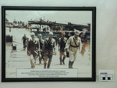
Framed Photograph, Surrender of Japanese at Balikpapan, 1945
Japanese Commanders crossing a pontoon bridge under guard by Australian soldier on the way to the official surrender of Japanese forces in Balikpapan in (Dutch East Indies) Indonesia 1945. This was a major event in the ending of World War 2. Following the japanese surrender the Local population began it push for independance. Framed photograph (copy) of Japanese Commanders surrendering at Balikpapan. Black frame and glass covered. The Japanese Command staff with a Japanese general and aid-d-camp (Captian)carring his breif case along with other staff members. In the background here are 2 American PT boats with American naval personal .Note American flag flying in the top left corner. There are several American landing craft next to a Japanese landing barge. The Japanese landing bardge has the required surrender markings which is a green square with a white cross on top right of photo. The Australian soldier following the Japanese soldiers is wearing slouch hat and gungle green uniform. Along the docks are native workers.Paper discription on lower photograph with details of item description, where photo obtained from and donated by.ww2, japanese, surrender, balikpapan, generals, americans, pt boats, japanese landing bardge, american landing craft, dutch east indies -
 Hume City Civic Collection
Photograph, early 1990s
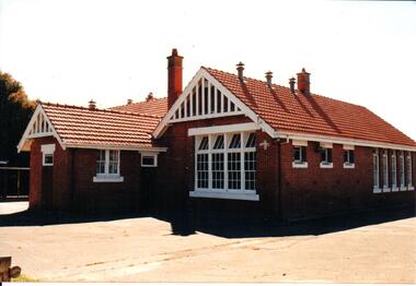
The brick building was constructed in 1911/1912 and replaced an earlier school building. In 1942/43 the school building was extended to cope with the increased population in Sunbury. The State School remained on the Macedon Street site until 1999 when it was relocated to the restored former Industrial School at Jacksons Hill.A coloured photograph of the former Sunbury State School No. 1002. It is a red brick Federation building with a red terracotta tiled roof and wooden white painted trims. There are two stepped brick chimneys with terracotta chimney pots and six air vents protruding from the roof. There is a small porch at the front of the building.carirns, j. f. dr., eadie, peter, education department, george evans collection -
 8th/13th Victorian Mounted Rifles Regimental Collection
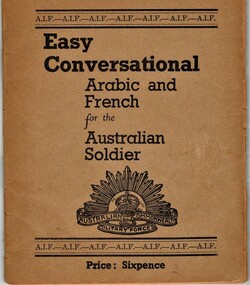
Booklet
Australian soldiers of the 2nd AIF departed Australia in 1940 en route to England, however this destination was changed to Egypt to defend the Suez Canal. When it became clear the AIF would remain in the Middle East publications such as this small phrase book was published to enable communication with the local population.Example of commercially published booklet for soldiers proceeding to Middle East in WW11.Buff covered booklet " Easy Conversation Arabic and French for the Australian Soldier." 30 pages, soft cover, saddle stitched and stapled.phrase book, arabic, french -
 Sunbury Family History and Heritage Society Inc.
Photograph, c1980s
The building in the photograph is the recently built stadium which is part of the Boardman Reserve Sporting Complex in Mitchells Lane. This complex caters for Australian Rules Football, basketball, netball and other community sporting activities for the Sunbury Community. The stadium was built during the 1980s when the town's population was on the increase.A coloured photograph of a large colour bond building with a brick annex side at the entrance of a reserve.boardman reserve sporting complex, australian rules football, basketball -
 Federation University Art Collection
Work on paper - Printmaking - Lithograph, Gill, Samuel Thomas, Creswick Creek (Near Ballarat) from Spring Hill, 1887
In 1887 Creswick had a population of around 25,000 people during the gold rush but now is only about 1/10th of its original size. This item is part of the Federation University Art Collection. The Art Collection features over 2000 works and was listed as a 'Ballarat Treasure' in 2007.Framed hand coloured lithographic print from Wither's 'History of Ballarat' showing two diggers looking over Creswick Creek. A scar tree is depicted in the left foreground. The work was published in the 1887 History of Ballarat by W.B. Withers. art, artwork, creswick, samuel thomas gill, s.t. gill, f.w. niven, available, lithograph, printmaking, scar tree, near ballarat, spring hill, scarred tree -
 Stawell Historical Society Inc
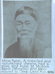
Photograph, Mr Mow Fung from Deep Lead -- Studio Portrait
Portrait of Mow Fung Deep Lead plus Grave Headstone. In the twentieth Century the Chinese population around Stawell continued to dwindle. One family whose associations with the area was the Mow Fungs. refer Page 117 "Good Country for a Grant" A History of the Stawell Shire. by Robert Kingston. A photograph of a male Chinese with a beard and dressed with a skull cap. The photograph has a blush tint.Mow. Fung... A respected and naturalized Chinese had a store and hotel at Mullock Bank (Morella) and later moved to Deep Lead. Photo 1896stawell chinese mullock bank morella -
 Melbourne Tram Museum
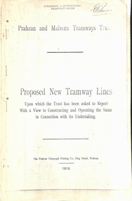
Document - Report, Prahran & Malvern Tramway Trust (PMTT), Proposed New Tramway Lines, Original 1915
Photocopy - 16 sheets report - "Proposed New Tramway Lines - upon which the Trust has been asked to Report With a View of Constructing and Operating the Same in Connection with its Undertaking" by the Prahran Malvern Tramways Trust - dated August 1915. Reports on possible tramways: Toorak Road - Prahran to Burke Road Hawthorn - 1.85miles Glen Eira Road - Murrumbeena Railway station to Barkly St St Kilda - 5 miles Brighton and Moorabbin - Glen Huntly Road to Sandringham - 7.4 miles South Melbourne and St Kilda - Princes Bridge - 4.85 miles Princess St and Willsmere Road Kew - 1 mile. Tooronga Road Malvern - 1 mile Brighton Road St Kilda - .83 miles Looks at the population required to justify tramways, income per head, cost of construction and operation, each line and how it fits with the necessary criteria for a profitable operation. Appendix looks at existing tramways, population statistics, and tramways performance in other cities. Photocopy made from original documents. .1 - Original copy from donation of Norm Cross added 10-9-2018 - complete with stapled blue cover, and fold out appendix sheet.Has the stamp on the rear of the first page "The property of the Tramway Museum Society of Victoria Ltd." On the top right hand corner of the second page, has the stamp "Melbourne & Metropolitan Tramways Board"trams, tramways, pmtt, new tramway, toorak rd, glen eira, south melbourne, st kilda, kew, moorabbin, sandringham -
 City of Moorabbin Historical Society (Operating the Box Cottage Museum)
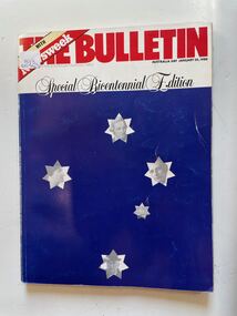
Book, Australian Consolidated Press Ltd, The Bulletin (Special Bicentennial Edition) January 26th.1988, 1988
A large dark blue soft cover book with the the title written in large red letters at the top,on a white stripe underneath this is written Special Bicentennial Edition and under this on the dark blue are five white stars depicting the Southern Cross four of the stars has the face of a historical person on it and the fifth star has an old sailing ship.non-fictionbicentennial, settlement, politics, religion, sport, food, 1788, business, population, booms, anglo australia. -
 Victorian Aboriginal Corporation for Languages
Book, Department of Aboriginal Affairs, Aboriginal social indicators 1984, 1984
maps, b&w photographs, tables, graphsstatistics, population, land, health, housing, education, employment, income, legal, finance, sport and recreation -
 Kiewa Valley Historical Society
Papers - History of the Mt Beauty Fire Brigade
The Mt Beauty Fire Brigade commenced under the State Electricity Commission of Victoria in 1948. It was a (Country Fire Authority) C.F.A. Brigade from December 1961 and later an Urban Fire Brigade. The Fire Brigade and its Ladies Auxillary provided many community activities as well as protecting the population.The State Electricity Commission of Victoria established the Mt Beauty Fire Brigade during the construction of the Kiewa Hydro Electric Scheme. Its Ladies Auxillary was very active and involved, serving the community by raising money for the brigade and providing social occasions such as 'Deb' balls.One set of two pages and one set of eleven pages of the History of the Mt Beauty Fire Brigade and Mt Beauty Urban Fire Brigade respectively. Typed and photocopies.mt beauty fire brigade; ladies auxillary; deb balls -
 Conservation Volunteers
'Conservateers' T-Shirt (1983) - do you have one?, Unknown, 'Conservateers' T-Shirt (1983), 1988
By the early 1980's, the population of Little Terns visiting Rigby Island in the Gippsland Lakes had fallen to a low level as the species has a very low reproduction rate. ACTV arranged, at short notice, a "Tern watch" which was literally volunteers babysitting the birds. The project was very successful.This was the first ACTV project which actively used volunteers to protect a threatened species. The Little Terns are now off the official list of endangered species. It was among the first of our corporate sponsorships.Cream coloured, t-shirt, with ACTV logo, blue ANZ logo and text "Tern Watch '88" on front.gippsland, anz bank, little tern, tern watch, gippsland lakes, actv, conservation volunteers, endangered species, successful species recovery -
 Kiewa Valley Historical Society
Photo - framed - Mt Beauty Central School
The school was built to educate the increasing number of children of the Kiewa Hydro Electric Scheme population. The school opened in 1948 in the Recreation hall and in the new building (photo) in 1950. A new wing was built in 1951 and became the Mt Beauty Higher Elementary School in 1953. By 1958 it had 617 pupils.Mr George Redfern was the Head Teacher for one year in 1951.Large black and white photo framed in thick wood and backed with cream cardboard. At the bottom on the wooden frame is a metal inscription.Inscription: Mt Beauty Central School / Presented to / Mr G. Redfern / as a token of esteem from / Mothers Club Committee / School Committee / 19.6.52mt beauty state school, kiewa hydro electric scheme -
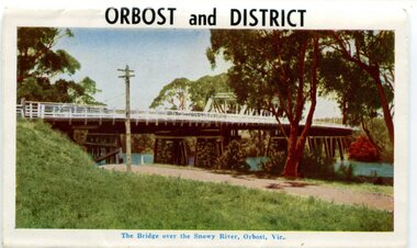 Orbost & District Historical Society
postcard series, 1960s
Included are photographs of the Orbost township, the Snowy River at Marlo, Gypsy Point, Buchan Caves and Bairnsdale. In the 1960s Orbost had a population of 4000 and was a major tourist attraction in Eastern Victoria with sufficient accommodation and facilities. It was the major town close to several national parks with access to either the surf or the snow. These postcards are pictorial records of Orbost in the 1960s. Postcards are very interesting records of places. architecture and transport.A colour postcard series with photographs of Orbost and the district. The cover photograph is of the Snowy River Bridge. There is an information card.Each photograph is labelled. at the bottom.postcards-orbost postcards-east-gippsland -
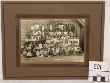 Myrtleford and District Historical Society
School Photograph, J. Check, Myrtleford State School 955, 1922, Circa 1922
This whole of school photograph depicts the school pupil population in the "prosperous twenties". The pupils have been congregated against the external wall on the SE side of the school outside the Head Master's office and pupil's cloakroom. This is one of several photographs taken in 1922; others feature composite groups of classes. The photograph records the post-war school population at its peak in 1922. The following year,St. Mary's Convent School would commence and numbers at Myrtleford State School 955 would decline for the rest of the decade. The coverage of the whole school population provides a snapshot of all families attending the school.A monochrome photograph of the whole pupil enrolment at the Myrtleford township schoolSchool and Photographer name inscribed: "State School Myrtleford, 1922" "J. Check"myrtleford state school 955 -
 Bendigo Historical Society Inc.
Book - Geographical dictionary
The Gazetteer presents an extensive a to z list of Victorian towns and villages, lakes, rivers and creeks, islands, bays, hills and mountains, runs and other localities and features. Entries include latitude and longitude, populations, proximity to other towns, local industries, coach and mail runs, hotels, churches and schools.Bailliere's Victorian Gazetteer and road guide containing the most recent and accurate information as to every place in the colony. Brown hardcover book, on the spine: Victorian Gazetteer with map 1865. The first and last pages are advertisements. The book has 442 pages listing every place in the colony. The map is not included. Compiled by Robert P. Whitworth. Published by Bailliere, Regent Street Unreadable name on first page and the name of F. Houston in blue pen on first page geographic dictionary, colony of victoria -
 Bendigo Historical Society Inc.
Book - STRAUCH COLLECTION: WHROO CEMETERY VICTORIA
Although the first recorded burial at Whroo (7 km south of Rushworth) was in 1858, it is believed earlier unrecorded burial took place. The official cemetery was established in 1860 and contains approx. 400 burials although many are unmarked. There is also a Chinese section as in 1863 17% of the population was Chinese in 1863.Red Spring binder containing list of interments in Whroo Cemetery with maps & illustrations.James & Nicola Thomsonplace, cemetery, whroo, victoria-whroo-rusthworth-history-cemetery -
 Ballarat and District Irish Association
Photograph - Colour, Shamrocks
Port Fairy is one of the earliest pioneered areas in Victoria.Whaling and sealing were the primary industries in the early years and some of the 19th century architecture remains. In 2012 the seaside town of Port Fairy was voted the world's most liveable town with a population of less than 20,000 at the 2012 LivCom International Awards.Digital photograph of shamrocks carved in marble from a headstone in the Port Fairy Cemeteryballarat irish, shamrock, shamrocks, headstone, cemetery, carving, port fairy -
 Sunbury Family History and Heritage Society Inc.
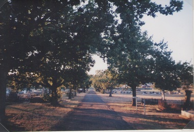
Photograph, Lydia Kenworth, Sunbury Cemetery, March 2001
The avenue of trees is along the main pathway of the old section of the Sunbury Cemetery. In 1862 the cemetery in Sunbury was laid out in Christian denominational sections. There were other sections set aside for paupers, heathens and pagans. Over the years the size of the cemetery has increased to keep pace with the growth of Sunbury's population.Sunbury Cemetery is one of the oldest cemeteries in the local area.A non-digital coloured photograph of an avenue of trees in a cemetery. The photograph is one of a collection of images that was entered in a photograph competition organised by the former Sunbury & District Heritage Association in March 2001.cemeteries, sunbury, sunbury cemetery -
 Kiewa Valley Historical Society
Postcard Circa 1950, Mt. Beauty Village, Kiewa Hydro-Electricity Project, circa 1950
This postcard was produced in the 1950's for the tourist trade in the Kiewa Valley and Alpine region. It encompasses the period when the State of Victoria was pressured by the ever increasing demand by industry and its population for electricity supplies. Hydro electricity was seen as an untapped natural resource to quench this demand. The Victorian Alps and the rivers flowing into its valleys was ideal for the construction of the Kiewa Hydro Electricity Scheme. The late 1940's saw the development of this scheme and the changing of sections of alpine landscape is covered by this and other postcards/pictures (tourists, construction workers, and established rural populations). This period in time was before the established wildlife and forest/nature groups became political activist who changed legislative acts to protect the environment. The regulatory pondage on the northern aspect of the village had no water over-spill from the unfinished power station.This rural region in 1950 (Kiewa Valley/alpine plains) was at most only significant to a smaller group of winter sports, summer hikers/horse riders and rural farmers/graziers. The numbers of tourists and the increase in the local resident population was boosted by the construction of the Hydro Electricity Scheme. This influx to the regional population resulted in a corresponding diversity in services and brought about an environment that responded to a growing level of tourists and thereby permitting this industry to grow more rapidly than it would have naturally. This postcard details an attraction to the "cleaner" method of providing electricity. This postcard was purchased in 1950 by a surveyor at Landford's Gap. The couple shown in this photograph would have been employed by the S.E.C. under the Kiewa Hydro-Electricity Scheme.This item is a scanned black and white photograph of a panoramic view of Mount Beauty Village in 1950 (a closed village, entry by pass only). The regulatory pondage has earthen walls but no water.See 0480 (A) -(D) and (F) for other photos of similar postcards"MT. BEAUTY VILLAGE KIEWA HYDRO-ELECTRIC PROJECT"kiewa valley tourism, victorian alps, alternate energy supplies, alpine population growth -
 Kiewa Valley Historical Society
Photograph of Kiewa Valley Panorama, Farming lands within the Kiewa Valley in1950s, Circa 1950
This photograph shows how (early to mid1900s), before the establishment of the Mount Beauty "gated" village, the Kiewa Valley was farmed and the scarce population was spread out over acres of productive land. This photograph catches a time before (what appeared to the local farmers as the invasion by a mass of construction workers) when this remote valley was part of a "lay back" rural landscape,occasionally visited by friends and some wayward tourists. The mountain ranges provided an adequate barrier against the way-would traveller. The immigration numbers coming into Australia was still quite small ( due to the "white" Australia policy) which was in force before World War II. After World War II a mass of displaced European refugees and migrants boosted the Australian population and provided for a greater degree of diverse professions and rural related work force.This photograph depicts the borderline in time between an exclusively rural based population and respective activities(early 1900s)to the present (2000 on wards) integrated village, tourist and retiree/holiday area. The time when land was exclusively used in agriculture is over and the impact of cheaper rural produce from Asian markets will see a shift of land useage and population activities. The Kiewa Valley is loosing its hiding place and is becoming more and more a source of untapped residential land. Black and white photograph of farming/grazing land useage, before the establishment of the Mount Beauty Village. Small pockets of residentual houses can be viewed. Road access (unsealed dirt) was typical of that provided in rural regions in the 1950s. The photo is on 200gms paper and not on photographic paper.kiewa valley in the early1900s, grazing in the kiewa valley, sec victoria -
 Eltham District Historical Society Inc
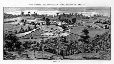
Photograph, Samuel Calvert, Eltham, The Illustrated Australian News, December 26, 1884, p212, 1884
A description in the newspaper near the illustration (page 210) reads as follows: "Eltham is a pretty little township on the Yarra Flats road, about 14 miles east north east of Melbourne, from which place there is communication by way of Heidelberg. It has a population of nearly 400 inhabitants, but in addition it is the centre of a large district extending over about 203 square miles, having a population of 2344. The land in the district is mostly used for grazing purposes, although as a rule the small farms grow a good deal of wheat, oats and other agricultural produce. A large quantity of fruit, especially raspberries and strawberries, is also produced, the rich alluvial flats along the creek upon which the township is situated being very well adapted for that purpose. Gold has also been found in the vicinity of the township, but not in remunerative quantities". This photo forms part of a collection of photographs gathered by the Shire of Eltham for their centenary project book,"Pioneers and Painters: 100 years of the Shire of Eltham" by Alan Marshall (1971). The collection of over 500 images is held in partnership between Eltham District Historical Society and Yarra Plenty Regional Library (Eltham Library) and is now formally known as 'The Shire of Eltham Pioneers Photograph Collection.' It is significant in being the first community sourced collection representing the places and people of the Shire's first one hundred years.Digital imageshire of eltham pioneers photograph collection, eltham, illustrated australian news -
 Melbourne Tram Museum
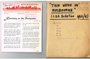
Magazine, City Development Association, "This week in Melbourne", 1961
Set of 24 magazines - each a folded foolscap sheet printed on semi gloss paper with a red printed heading, titled "This week in Melbourne", published by the City Development Association - 1961. Looks at issues that affect the Melbourne CBD, traffic, planning, MMBW, open space, population, parking, overseas practices, City of Melbourne, water supply, freight terminal. Published on a fortnightly basis. All contained loosely within a brown card folder with the title written on the front and issue numbers. 1961 issues are: 2-8, 10, 12-15, 18-21, 28-31, 33-36.Has AETA stamp on front cover with the letters "3CT with a running number alongside."trams, tramways, melbourne, city of melbourne, public transport, road transport, traffic control -
 Orbost & District Historical Society
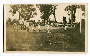
black and white photograph, Wilson, Len G, 1920s
The Orbost football club players were known as the Busters and wore green and gold guernseys. An Orbost football team has participated in the East Gippsland League since the early 20th century. In 2003 in response to a dwindling population, the Snowy Rovers and Orbost Football Clubs were driven to merge into the Orbost Snowy Rovers Football clubs, through their many changes, have always been an important social fabric of the community. Sport is often regarded as an important part of life in rural Australia, contributing to community identity, sense of place, social interaction and good health.A black / white photograph of men playing football. Three men are jumping for the ball. The goal posts are on the right side. A large group of spectators are at the rear behind a fence.recreation sport-football orbost-football-club -
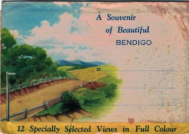 Bendigo Historical Society Inc.
Postcard - A Souvenir of Beautiful Bendigo, abt 1940s
Nucolorvue was a company who specialised in souvenirs and postcards, although they have also published some Australiana books. This postcard can be dated to late 1960's when the population of Bendigo was around 32,000 and before Australian measurements became metric in 1970. The company moved to its current site in Mulgrave c. 1973.A Souvenir of Beautiful Bendigo - Twelve hand coloured postcards of Bendigo, scenes include parks, churches, gardens and roadways, published by Nucolorvue Productions, Menton, Victoria.history, bendigo, winifred jennings collection, postcards of bendigo -
 The Beechworth Burke Museum
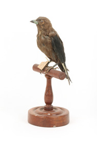
Animal specimen - Dusky Woodswallow, Trustees of the Australian Museum, 1860-1880
The Dusky Woodswallow is often found in flocks which can be located in two separate populations. The Eastern population if located in Atherton Tableland in Queensland south to Tasmania and west to Eyre Peninsula in South Australia. The other population is found in south-west Western Australia. They reside in open forests and woodlands. This species is surprisingly aggressive and may fight with other Woodswallows for territory and nest sights. They will even chase raptors away from their homes. This species flies in flocks of around 10 to 30 birds which cluster together. In terms of diet, these birds eat insects and nectar from flowers. This specimen is part of a collection of almost 200 animal specimens that were originally acquired as skins from various institutions across Australia, including the Australian Museum in Sydney and the National Museum of Victoria (known as Museums Victoria since 1983), as well as individuals such as amateur anthropologist Reynell Eveleigh Johns between 1860-1880. These skins were then mounted by members of the Burke Museum Committee and put-on display in the formal space of the Museum’s original exhibition hall where they continue to be on display. This display of taxidermy mounts initially served to instruct visitors to the Burke Museum of the natural world around them, today it serves as an insight into the collecting habits of the 19th century.This specimen is part of a significant and rare taxidermy mount collection in the Burke Museum. This collection is scientifically and culturally important for reminding us of how science continues to shape our understanding of the modern world. They demonstrate a capacity to hold evidence of how Australia’s fauna history existed in the past and are potentially important for future environmental research. This collection continues to be on display in the Museum and has become a key part to interpreting the collecting habits of the 19th century.The Dusky Woodswallow has largely deep brown colouring with some areas of grey on the head, neck and chest. There is a deeper brown colouring between the wings on the back of the specimen and the wings are black. This bird has a small curved bill which is grey and white. The legs are dark grey and the bird has long talons with an extra long toe in the centre. The eyes are made of brown glass with a back pupil. The bird is styalised standing on a wooden mount and has a paper identification tag attached to its right leg.[torn] / 9 /taxidermy mount, taxidermy, animalia, burke museum, beechworth, australian museum, skin, reynell eveleigh johns, bird, australian birds, swallow, woodswallow, dusky woodswallow -
 Federation University Historical Collection
Documents - Reports, Reports and articles relating to Big Cats
The articles were used for research into Australian Animal Folklore.Research documents relating to reports into big cats and other animals of Australian Folklore. (1) Acclimatizing the World: A history of the Paradigmatic Colonial Science by Michael A. Osborne. (.2) A novel microsatellite (STR) marker for forensic identification of big cats India by Anju Singh et al. (.3) The Feral Cat by Ian Mahood (.4) Report Re Faeces Suspected to Be from a Big Cat by David Cass (.5) Indentification of Leopard, Panthera Pardus, in South Eastern Australia by Analysis of DNA from Hairs by Stephen Frankenberg and david Cass. (.6) David Cass's Story by David Cass (.7) Animal calls mistaken for big cats- Graeme Ambrose (.8) Review of Cat Ecology & Management Strategies in Australia - Elizabeth Denny and Christopher Dickman (.9) Ecology of the Feral Cat, Felis catus (L.), in South eastern Australia. III.*Home ranges and Population ecology in Semiarid North-West Victoria -Evan Jones and Brian Coman. (.10) Feeding Ecology and population Dynamics of the feral cat (Felis Catus) in relation to the availability of prey in central-eastern New South Wales - Robyn Molsher, Alan Newsome and Chris Dickman. (.11) Thylaine associated with the Royal Zoological Society of New South Wales - R.N. Paddle. Australian Animal Folklore Collectionaustralian animal folklore collection, david cass, brisbane ranges natinoal park, big cats, bruce, meredith, anakie, otway ranges, faecesologist, puma, black leopard, peter chapple, otway, stephen frankenburg, faeces, helen mccracken, feral cats, mythical, myth, folklore -
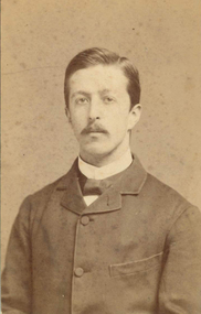 Federation University Historical Collection
Photograph, John William Lindt, Miles Barraclough, Head teacher of Happy Valley School, c1884, c1884
Happy Valley was originally called Lucky Woman's. The School opened under the name of Happy Valley in 1883, and the brick building probably dates from that time. Miles Barraclough was the head teacher from 1873 to 1887. When mining ceased the population declined and the land reverted to grazing. The School closed in 1940. (Visions and Realisations)Sepia photo of Happy Valley School Teacher, Mr Miles BarracloughVerso Handwritten "Sept-84 Mr Barraclough School teacher Happy Valley" Printed "From J.W. Lindt Photographer Prize Medalist Philadelphia Paris Sydney Brisbane Sandhurst Melbourne 7 Collins Street East Melbourne.happy valley, happy valley school, barraclough, j.w. lindt, miles barraclough, miles barrowclough, lucky woman's, myles barraclough, happy valley school principal -
 Ithacan Historical Society
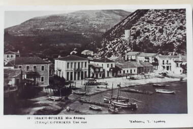
Photograph, Frikes, Ithaca
An old image of the Frikes, a small port village in the north of Ithaca where ferries berth to offload passengers and goods from other nearby islands and passengers and goods are also loaded from Ithaca. It has only a small permanent population but in the summertime it comes alive with tourists who enjoy the restaurants and cafes that line waterfront. A print taken from a post card of the port of Frikes on Ithaca, Greece. The details are written in Greek across the bottom of the card. -
 Warrnambool and District Historical Society Inc.
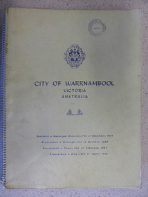
Book, City of Warrnambool, 1961
This book is a report on the development of the city of Warrnambool in 1960. The seven sections it covers are, 1 Town Planning and beautification 2 Culture and Education 3 Town promotion and tourism 4 Recreation and youth work 5 Industrial development 6 Town Development 7 Community organization. There is a very comprehensive study on each of the sections. The population at this time was 15697. This report has social, historical and research significance. It is a comprehensive study of the city as it was in 1960, listing clubs, organisations schools and sporting clubs. It provides information on any development such as the Olympic pool and St Pius X1 school in West Warrnambool and the building of the Pontings store on the Lava St corner. It relates facets of our history which have changed dramatically in the last 60 years with the report on Peter Hand’s tobacconist having 3 vehicles covering the district travelling 4700 miles a month selling cigarettes. It provides statistical evidence for organisations such as Australia Post, train and freight services and the hospitals.Large yellow soft card cover with spiral binding. Title and city details are printed in blue on cover with city logo towards top of front cover. Pages are not numbered. It is divided into seven sections, each denoted by blue page with section title printed in blue on page.Circular stamp on front cover,” Warrnambool Standard Proprietary Limited.” K L Arnel town clerk. warrnambool 1960, warrnambool directory 1960 -
 Kiewa Valley Historical Society
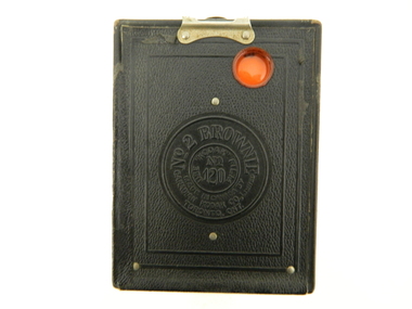
Camera Box Brownie, 4/8/1925
This item represents a period in time when there was the start by manufacturing industry for targeting the medium to lower socio and economic strata of the purchasing public. It was the beginning of cheaper mass produced items for the non professional (photographer in this instance) recreational minded public. The availability of low cost items was required by an ever increasing population hungering for the "do it yourself" amateur.This camera was owned by Margaret (Peg) Shefford nee Turner, who retired to Mount Beauty in the mid 1980s. The camera was purchased in 1920 and used up to the 1940's when her her daughter, Midge Clooney used it. When the Shefford family emigrated from England to Australia (1953), it was used to take photos of the ship voyage.This item is a Campfire Box Brownie. Model "F". It is a black vinyl covered tin box shell. It has a short leather hand strap (110mm) (stamped "BROWNIE") on the top side of the box, fastened by a metal stud at each end. There are two clasps holding the front and rear sides. Viewer (photo frame number) and lens (apertures) are on opposite sides.Stamped within a circular section on the back section is "No 2 BROWNIE" underneath,"MODEL F" in smaller letters "MADE IN CANADA BY CANADIAN KODAK Co., Limited, TORONTO, ONT". a smaller circle within has "USE KODAK FILM No_ 120"portable camera, photography, hobby, low cost camera