Showing 19434 items
matching east
-
 Orbost & District Historical Society
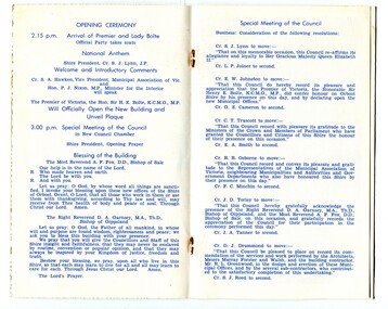
Invitation, 1969
The current building was opened on Friday 28th February 1969 by the Premier of Victoria, The Hon. Sir Henry E. Bolte, K.C.M.G., M.P. The Shire of Orbost was a local government area about 380 kilometres east of Melbourne, the state capital of Victoria, Australia. The shire covered an area of 9,347 square kilometres and existed from 1892 until 1994. Originally, Orbost was part of the Bairnsdale Road District which was created on 30 April 1867. Splitting away as part of the Shire of Tambo in 1882, Orbost was first incorporated as a shire in its own right as the Shire of Croajingolong on 30 May 1892. It received its present name on 17 February 1893. On 3 January 1913 part of its western riding was annexed to Tambo as its Cunninghame Riding. Local governments play an important role in the lives of citizens in Australia. Local government authorities exist to provide services and amenities to local communities, and are also responsible for regulating and providing services for land and property in their district. This item is representative of a time when Orbost had its own Shire Council. A stapled program and invitation to the official opening of the new Orbost Shire Council Municipal Offices. A light blue card with the Orbost Shire Council insignia and gold print on front. The invitation is addressed to the secretary of Orbost Historical Society Judith Walcott.handwritten in blue pen - "Judith G Walcott"orbost-shire-council -
 Orbost & District Historical Society
black and white photograph, first half 20th century
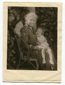
The lady in this photograph is probably Mrs Eveline Trevaskis who taught at the Wairewa School. Mrs. Trevaskis taught school from her early 20’s in different parts of Victoria. She gave it up to get married, has four children and 11 grand-children. Four of her grand-children are at Wairewa school. Mrs. Trevaskis went back to teaching during the wartime teacher shortage. She relieved at Buchan East State School for two years, getting up at 3.45 am to drive the 24 miles in pony and jinker. Wairewa State School, No. 3739 was built in 1923. The school closed at the end of 1973. Mrs Trevaskis was the teacher at Wairewa 1919-22 and 1945-1956. ( more information in News letter No. 123 NOVEMBER, 2015 - John Phillips)This item is associated with the history of education in East Gippsland.A black / white photograph in a small cream coloured folio. It is of an older lady seated on a chair with a young child on her lap. The child is laughing.inside cover - "Teacher at Wairewa"educatio-east-gippsland wairewa-state-school trevaskis-eveline -
 Orbost & District Historical Society
framed coloured photograph, 1978
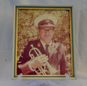
This is a photograph of Alf R. Barling who was the bandmaster of the Orbost Municipal Band from 1961 - 1978. He played bass and cornet. This photographer, Peter Fagg, worked as a scientist with the Department of Sustainability and Environment (now DELWP) to study dieback in eucalypts. He specialised in the silviculture of the eucalypt forest types of South-East Australia for most of his 40-year career, which started with the Forests Commission Victoria. He was in Orbost from 1968 - 1973. The first Orbost Brass Band was formed in 1889. Around 1908 the town band split and the Orbost Workers' Band was formed. Eventually the two bands merged in 1913 to reform as the Orbost Municipal Band under conductorship of Charles Spink. Further info and Ref: In Times Gone By - Deborah Hall The various Orbost bands over the years played a major role in community activities providing entertainment and musical experiences for the many members.A coloured photograph of a man in a band uniform holding a brass instrument ( a cornet?). The photograph has been taken outdoors. The photograph is in a frame with gold esges.on back - Alf R. Barling 1977barling-alf orbost-municipal-band -
 Glen Eira Historical Society
Plan - Warrigal Road, Oakleigh
Documents about a small portion of land on Warrigal Road Oakleigh, now Oakleigh East. A Letter dated 29/05/1952 from Gas and Fuel Corporation of Victoria to Mr. L.P. Simmonds requesting valuation of land for proposed widening of Warrigal Road. A plan of Survey, no.5474, for Crown portion of Parish of Moorabbin and Parish of Mordialloc for owner The Brighton Gas Coy Ltd. New Street Brighton. Mortgages to the National Mutual Life Association. A letter dated 04/06/1952 from Gas and Fuel Corporation of Victoria in reference to Warrigal Road and Centre Road from the Country Roads Board who desire to acquire the land. Handwritten calculation notes and price for valuation, most likely as an attachment to the letter dated 04/06/1952.gas and fuel corporation, warrigal road, centre road, moorabbin council, simmonds l.p, survey plan, county of bourke, the brighton gas company ltd., country roads board, the national mutual life association of australia ltd., bentleigh east -
 Orbost & District Historical Society
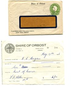
envelope and receipt, Snowy River Mail as "Mail" Print, May 17 1956
This receipt was issued to R. C. Morgan of Orbost. on May 17, 1956. It was for rent of reserve for six shillings. It was issued by the Orbost Shire Council. The Shire of Orbost was a local government area about 380 kilometres east of Melbourne, the state capital of Victoria, Australia. The shire covered an area of 9,347 square kilometres and existed from 1892 until 1994. Originally, Orbost was part of the Bairnsdale Road District which was created on 30 April 1867. Splitting away as part of the Shire of Tambo in 1882, Orbost was first incorporated as a shire in its own right as the Shire of Croajingolong on 30 May 1892. It received its present name on 17 February 1893. On 3 January 1913 part of its western riding was annexed to Tambo as its Cunninghame Riding. Local governments play an important role in the lives of citizens in Australia. Local government authorities exist to provide services and amenities to local communities, and are also responsible for regulating and providing services for land and property in their district. This item is representative of a time when Orbost had its own Shire Council. A widow - faced envelope with a green threepence stamp top right corner. At the top is "Shire of Orbost". Bottom right is "If not claimed within 7 Days please return to SHIRE HALL, ORBOST".There is a receipt to R.C. Morgan for 6/- being for the "rent of reserve" and signed by L.A. Walker. It has the Orbost Shire logo in the top left corner.orbost-shire-council morgan-r.c. -
 Whitehorse Historical Society Inc.
Clothing - T- Shirt, C. 1970 - 1993
As AttachedWhite T-Shirt with burgundy school emblem on left side. Collar and short sleeves in polyester/cotton. Refer ND2316 and ND2404Blackburn Eastcostume, children's uniform -
 Port Melbourne Historical & Preservation Society
Photograph - Guernsey House, Esplanade East, Port Melbourne, Arthur Rowan, 1986
As a member of the Port Melbourne Historical and Preservation Society, donor Arthur ROWAN photographed a series of significant buildings in the Port and South Melbourne area over several years. A selection of nineteen of these was presented to the Port Melbourne Society in 1993. Guernsey House, 232 Esplanade East. Private home established in 1883 [Eastern shore of Lagoon] First owner: Peter GRUT and his wife Mary, parents of Henry Brouard GRUT, Peter Gallienne GRUT and John Bichard GRUT. Peter G and John B both became architects.Small print mounted on white card, with mounted, typed caption: Guernsey House, 232 Esplanade Eastbuilt environment - domestic, sandridge lagoon, arthur rowan, peter grut, guernsey house, mary grut, peter gallienne grut, henry brouard grut, john bichard grut -
Whitehorse Historical Society Inc.
Document, Archaeology Assessment, 1/11/2002 12:00:00 AM
City of Whitehorse archaeology assessment citing 4 properties identified.City of Whitehorse archaeology assessment citing 4 properties identified: The Burwood Uniting Church, Burwood East; The Wattles, Vermont South; Strathdon Homestead; Montana, Mitcham. Prepared by Biosis Research Pty. LtdCity of Whitehorse archaeology assessment citing 4 properties identified. city of whitehorse, uniting church, burwood east, wattles, vermont south, strathdon homestead, montana, mitcham -
 Brimbank City Council Art Collection
Photograph, Robert Pointon, Twin Pines, 1988
Local LandscapeEast of Fairbiarn Road, South Sunshine, looking east - AR0002landscape, photograph -
 Ballarat Tramway Museum
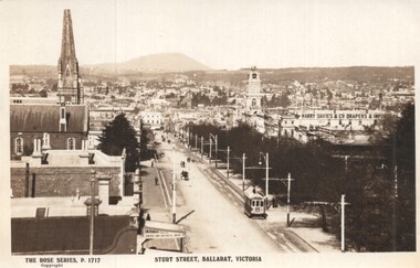
Postcard - Sturt Street Ballarat, Victoria, Rose Stereograph Co, 1920s?
Photo taken from the City Fire Brigade station at the corner of Sturt and Raglan Streets, looking east towards Mount Warrenheip. Has an eastbound ESCo tram. Photo shows the overhead structures, Harry Davies & Co. Drapers Importers, Ballarat Town Hall and the general view of the city. On the rear is a large Rose symbol and publisher details.Yields information about Sturt St during 1920sPostcard - Rose Series P 1717, Sturt Street looking east. Second copy - cigarette card size - 63mm x 87mmHas an address in Macarthur St, Ballarat on rear. Second copy has in ink "To Ken from Paul Kiwi4755"ballarat, sturt st, fire watch tower, harry davies -
 Ballan Shire Historical Society
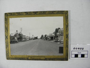
Photograph - Photograph. Inglis St. Ballan, Inglis Street in Ballan, c 1930/40
Inglis Street of Ballan .circa 1930/40.The photograph is looking East. Parts of the Mechanics Institute and Free Library can be seen, as can the butcher shop, and on the opposite side of the Street the Ballan Hotel and Post and Telegraph office.Black and white photograph of Inglis Street Ballan.Looking East. Photograph is on a cardboard backing with an ornate surround of green and gold. Cars and a truck circa 1930/40 are parked in the street.The word Ballan written on bottom of surround under the photographtelegraph office, car, mechanic institute, butcher shop, delivery truck, 1930 40 cars -
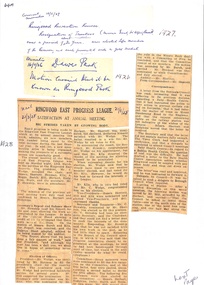 Ringwood and District Historical Society
Newspaper, Newspaper Articles Ringwood Borough Council from 1906 to 1929
18 pages of newspaper articles featuring council reports on Ringwood and Ringwood East ranging from the years 1906 to 1969. Featuring articles: Ringwood East Progress League, Ringwood East Railway League, Ringwood East Reserve, Ringwood East School Committee and the Ladies Guild. East Ringwood Recreation Ground. -
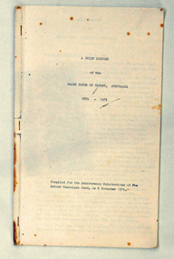 Orbost & District Historical Society
booklet, A Brief History of the Brass Bands of Orbost Australia 1889-1975, 8.11.1975
This booklet was compiled for the anniversary celebrations of the Orbost Municipal Band on November 8, 1975. It was compiled by Peter Fagg who worked as a scientist with the Department of Sustainability and Environment (now DELWP) to study dieback in eucalypts. He specialised in the silviculture of the eucalypt forest types of South-East Australia for most of his 40-year career, which started with the Forests Commission Victoria. He was in Orbost from 1968 - 1973. The first Orbost Brass Band was formed in 1889. Around 1908 the town band split and the Orbost Workers' Band was formed. Eventually the two bands merged in 1913 to reform as the Orbost Municipal Band under conductorship of Charles Spink. The band continued for many years but was later disbanded and again reformed. This was to happen a number of times, the last time being in 1961 and continuing through to the late 1970's. Further info and Ref: In Times Gone By - Deborah HallThe various Orbost bands over the years played a major role in community activities providing entertainment and musical experiences for the many members.A 12 pp stapled booklet compiled for the anniversary celebration of the Orbost Municipal Band. It has been typed in black ink on foolscap sized white paper.orbost-municipal-band music-orbost fagg-peter -
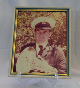 Orbost & District Historical Society
framed coloured photograph, December 1978
Mr E. Knight was the president of the Orbost Municipal Band from 1972 - 1978. The photographer, Peter Fagg, worked as a scientist with the Department of Sustainability and Environment (now DELWP) to study dieback in eucalypts. He specialised in the silviculture of the eucalypt forest types of South-East Australia for most of his 40-year career, which started with the Forests Commission Victoria. He was in Orbost from 1968 - 1973. The first Orbost Brass Band was formed in 1889. Around 1908 the town band split and the Orbost Workers' Band was formed. Eventually the two bands merged in 1913 to reform as the Orbost Municipal Band under conductorship of Charles Spink. The band continued for many years but was later disbanded and again reformed. This was to happen a number of times, the last time being in 1961 and continuing through to the late 1970's. Further info and Ref: In Times Gone By - Deborah Hall The various Orbost bands over the years played a major role in community activities providing entertainment and musical experiences for the many members.A coloured photograph of a man in a band uniform holding a brass instrument ( a french horn?). It is under glass framed in a white and gold wooden frame.on back - ".....E. Knight.......Dec 1978"music recreation orbost-municipal-band knight-g. -
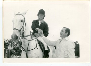 Orbost & District Historical Society
black and white photographs, Snowy River Mail, March 12 1980
These photographs were taken at the 1980 annual Orbost Show. The first photograph is of Mr Frank Rourke congratulating Combienbar rider, Gavin Chester, East Gippsland Olympian ( a member of the 1980 Australian team which did not compete in Moscow). He won the title of Champion Show Jumper riding his mount "Blue Trick" on Monday March 10 1980. The second photograph shows Mr Frank Rourke placing the winning ribbon around the neck of Gavin Chester's winning mount, "Blue Trick" The third photograph is the winner of the coveted R.L.Fisher Memorial Plate won by Eric Musgrave being congratulated by Mr Frank Rourke. Frank Rourke was the Gippsland and Northern manager. G. & N. sponsored the event which carried a prize of $500. On the left in this photograph is Mr J. Horstman, ring four judge.This is a pictorial record of a significant event in Orbost. This item is also associated with the Orbost Agricultural Society 's Annual Show which has been a major event in Orbost for over a century. Agricultural shows are an important part of cultural life in small country towns and the Orbost Show is an integral part of Orbost 's agricultural history.Three black / white photographs of a rider on horseback receiving congratulations. There are details on labels on the back of each photograph.orbost-show equestrian chester-gavin musgrave-eric show-jumping -
Glen Eira Historical Society
Plan - Brady Road, 10, Bentleigh East
A two page letter, dated 20/03/1973, from J M Smith and Emmerton Solicitors on behalf of Mrs J V Maxted to S P Simmons Estate Agent, requesting a sworn valuation of property at 10 Brady Road, Bentleigh East. The file also includes a photocopy of the certificate of title of the property, dated 28/02/1973. The certificate of title includes a plan (57mm x 65mm) of the property. The file also includes a two page letter, dated 30/03/1973, from S P Simmons responding to the request for valuation. Also included is a copy of these two pages. The file also includes one page of handwritten working notes for the property valuation including measurements and sales history of the property. The file also includes a hand drawn plan (114mm x 163mm) of the property with measurements.maxed j v, bentleigh east, brady road, wingate street -
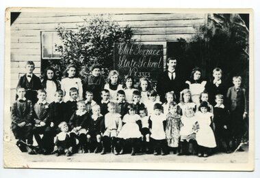 Orbost & District Historical Society
photograph, C 1900
Club Terrace, situated in East Gippsland, is important as a timber milling centre. The name probably derived from the ‘Ace of Clubs’ mine which operated for a time there and which took its name from the ‘Ace of Clubs’ cattle brand of still earlier days. The school first opened on 1st of February 1900, the teacher being Samuel Beaver. In 1960 the number of children enrolled grew too great for the little one-room school that had served so well. A modern type school of two rooms, built on a new site away from the mills, was occupied at the beginning of the 1961 school year when R. Lawry and his wife were the teachers. Later in the same year the school was officially opened by the DI Cyril Bowden. Also present were B. Evans, MLA, B. May, MLC and several Councillors from Orbost Shire. This school record is of immediate interest and value to the pupils and staff who have learned and taught in the Club Terrace State State School. The record also has a much wider significance, to the community in which the school is situated, as a record and research tool.A black / white photograph of a group of students and their male teacher standing outside a wooden building. It is labelled " Club Terrace State School No. 3343"on back - "about 1898"education club-terrace-state-school -
Lara RSL Sub Branch
Silk Maps, Four Collective maps
Scientific or research signifigance.Map 1....Silk Fabric ... "Western Pacific.Map 2....Silk fabric....Hong Kong /Canton.Map 3Cloth Map East Java South West Pacific.Map 4....Arakan/Irrawaddy fabric map.MMap 4....Restricted..Edition 1 -gsgsFabric Map 1;1,000,000 Map 3....No 25 Timor/No 26 East Java .Map 2 Hong Kong/Canton restricted MAP 1,NACI - HO. No.S 12. -
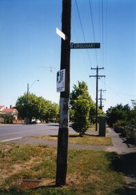 Ballarat Tramway Museum
Photograph - Colour Photograph/s set of 6, Neville Gower, 15/02/1997 12:00:00 AM
Group of six photographs taken on 15/2/1997 of some power poles in Drummond St. south that still carry the paintwork, faded and worn, of the SEC tramway system tram stops. 768.1 Drummond St. Sth & Urquhart St. - east side, looking north, with Neighbourhood Watch sign and bus stop shelter in background, with street name signs. 768.2 - Drummond St. South between Eyre & Dana St., east side, looking north. 768.3 - as for 768.1, but looking south. 768.4 - Drummond St. South & South Street. Pole photographed is at the north east corner of the intersection. 768.5 - as for 768.4 768.6 - as for 768.2, but looking south with Foundry Hotel in background. On rear in blue ink: 768.3 - "D.S. South E.side 15/2/97 & Urquhart St." 768.4 - "D.S.South East Side 15/2/97, south" 768.6 = "15/2/1997 D.S.Sth between Eyre & Dana E.Side"tram stops, drummond st. sth, sebastopol route -
 Ballarat Tramway Museum
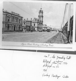
Photograph - Black & White Photograph/s - set of 2, 1915
Yields information about the appearance of the official last Geelong tram, No. 4, prior to its use that evening.4403.1 - Black and white (sepia coloured) reproduction of a photograph from an album photo from the Geelong Heritage Centre collection of the Post office, in Ryrie St Geelong, looking east, with tram 7 proceeding east, from Album No. 1954, photograph No. 50, 1915. 4403 - as above, but photos Nos. 48 and ?, also showing the Post Office, prior to the construction of the tramway and another view of the Post Office. Printed on Hewlett Packard paper.4303.1 - in ink on the front "Car 7, also proceeding East. Photograph album reference Nos. 1954, photograph No. 50, / 1915 / Geelong Heritage Centre" 4303.2 - "Geelong Heritage Centre / Photograph album ref no. 1954/50 1915" trams, tramways, geelong, ryrie st, tram 7 -
 Orbost & District Historical Society
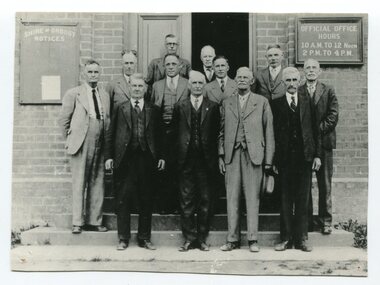
black / white photograph, first half 20th century
This is a photograph of some of the Orbost Shire councillors standing outside their council chambers. This photograph was taken before 1969 outside the previous council offices in Orbost. The current building was opened on Friday 28th February 1969 by the Premier of Victoria, The Hon. Sir Henry E. Bolte, K.C.M.G., M.P. The Shire of Orbost was a local government area about 380 kilometres east of Melbourne, the state capital of Victoria, Australia. The shire covered an area of 9,347 square kilometres and existed from 1892 until 1994. Originally, Orbost was part of the Bairnsdale Road District which was created on 30 April 1867. Splitting away as part of the Shire of Tambo in 1882, Orbost was first incorporated as a shire in its own right as the Shire of Croajingolong on 30 May 1892. It received its present name on 17 February 1893. On 3 January 1913 part of its western riding was annexed to Tambo as its Cunninghame Riding. Local governments play an important role in the lives of citizens in Australia. Local government authorities exist to provide services and amenities to local communities, and are also responsible for regulating and providing services for land and property in their district. This item is representative of a time when Orbost had its own Shire Council. A black / white photograph of a group of men standing in front of an open door of a brick building. On the left of the building is a Shire of Orbost notice board and on the right wall is a notice of the office opening hours - 10AM - 12 NOON 2PM - 4PMorbost-shire-council local government -
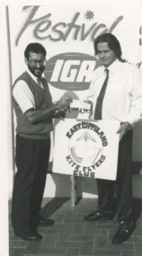 Lakes Entrance Historical Society
Photograph - Frank Arceri , Eric Strickland, Lakes Post Newspaper, 1/02/1993 12:00:00 AM
Frank Arceri of IGA Supermarket presenting five hundred dollars from IGA Community Awards to Eric Strickland President of East Gippsland Kiters Lakes Entrance VictoriaBlack and white photograph showing Frank Arceri of IGA Supermarket presenting five hundred dollars from IGA Community Awards to Eric Strickland President of East Gippsland Kiters Lakes Entrance Victoriasports, kites, supermarkets -
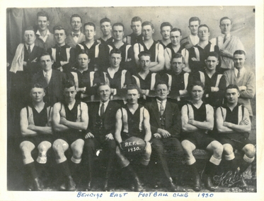 Bendigo Historical Society Inc.
Photograph - PURDY COLLECTION: BENDIGO EAST FOOTBALL CLUB 1930
The Bendigo District Football Association was superseded in 1913 by the Bendigo Football League. When competition resumed in 1919 after WW1 the League was composed of Eaglehawk, South Bendigo, Sandhurst and Bendigo East. In 1924 Echuca was included and Bendigo East was eliminated. Bendigo East moved to Golden City Football League and folded in the 1930s. Black and white photo stuck onto grey board, red back: Bendigo East Football Club 1930. Four rows of men dressed in football jumpers, trainers standing on sides. Middle front row player is holding a football with white writing ' B.E.F.C. 1930' printed on surface. Jim Purdy in right hand back corner.bendigo, sporting clubs, bendigo east football club -
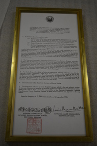 Wangaratta RSL Sub Branch
Document - Framed document, Japanese Surrender
Instrument of Surrender of Japanese Fores under the Command or Control of the Supreme Commander Japanese Expeditionary Forces Southern Regions within the Operational Theatre of the Supreme Allied Commander, South East Asia. Signed at Singapore on 12/9/1945 by Louis Mountbatten Supreme Allied Commander South East Asia.Gold coloured metal frame containing document with logo at top and signatures and red stamp belowInstrument of Surrender of Japanese Fores under the Command or Control of the Supreme Commander Japanese Expeditionary Forces Southern Regions within the Operational Theatre of the Supreme Allied Commander, South East Asiajapanese surrender, ww2, singapore, 12/9/1945 -
 City of Kingston
Pamphlet - Colour, Roy Dunn Pty. Ltd, Central Corner Estate Moorabbin and Highett, c. 1923
Sales plan for land in the suburbs of Highett and Moorabbin, bordered by Point Nepean Road and Wickham Road East incorporating William StreetThe developing urban area of Highett and Moorabbin within the City of Kingston. This land sale pamphlet illustrates the subdivision of land within the municipality and the changing demographic of the district as new houses are constructed close to infrastructure.Colour pamphlet advertising for private sale land in the Central Corner Estate in Moorabbin and Highett. Incorporates a map of the estate bordered by Point Nepean Road and Wickham Road East, with subdivisions also available on both sides of William Street. Handwritten in blue pencil on subdivision plan: a tick is drawn on subdivisions 2-18 Handwritten in blue pencil on subdivision 6: a box with an x inside Handwritten in blue pencil on subdivisions 10 and 12: S Handwritten in black ink on front page: [indecipherable] / McKittricks Handwritten in grey pencil on rear page: McKilhick / Nepean Rd Handwritten in grey pencil on rear page upside down: 160000 / 15 8300 [crossed out] land sales, estate, highett, moorabbin -
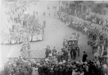 Ballaarat Mechanics' Institute (BMI Ballarat)
Arrival of Prince at East gardens
This photograph is from the Max Harris Collection held by the Ballaraat Mechanics' Institute. Please contact BMI for all print and usage inquiries.ballarat, prince, east -
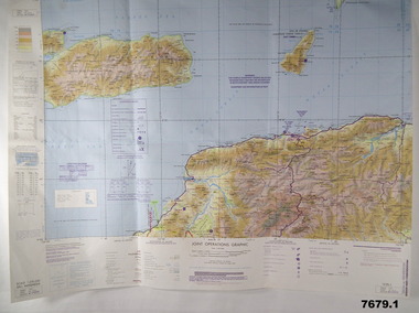 Bendigo Military Museum
Map - MAPS, EAST TIMOR, US Govt et al, 1975 - 1976
1. This is a coloured map. It's scale is 1.250,000 - called a jpoint operations graphic. It covers the North side of East Timor. Dili is in the centre. Its shows 4 Islands to the north of Timor. It shows Savu Fea, Ombai Strait, Wetar Strait. On bottom left of map it shows Batheade and the start of the New Border. Map - Series 159. Sheet 5C- 51-4. Edition 3-GSGS. 2. This is a coloured map. Its scale is 1.250,000 called a joint Operations Graphic. It manly covers West Timor. It shows Savu Sea in North and Timor Sea on south side. Series 1501. Sheet SC 51.7. Edition 3-GSGS. 3. This a coloured map. It's scale is 1.250,000. Joint operations graphic. This map shows the south side of East Timor and the Timor Sea. This map shows a highlighted New border. The major towns on South coast are KAMFNASA, BETANO. Map series 1501. Sheet SC 51-8. Edition 3 GSGS.1. Has highlighted "7 BSG" on coast. All maps show East Timor border highlighted in pink.east timor, maps, interfet -
City of Moorabbin Historical Society (Operating the Box Cottage Museum)
Booklet - St John's Church of England, East Bentleigh, The New Church, 1963
St John's Church of England first Church was built by the parish of Bentleigh in 1873. The present site, on the south- east corner of Centre and Tucker Roads, was donated by parishioner named John, in whose honour the new church was named St John’s. Erection of a modest brick and bluestone building began in October 1872, and the first service was held on Sunday, 11 May 1873. In the August 1961 a foundation stone was laid to begin the building of the new Church to meet the demands of the present congregation. It was designed by Gawler, Churcher & Boardman (David Gawler) and the builder was Colin D Mason. St John's Church of England Bentleigh was erected in 1873 and was integral to the spiritual well being and social life of the early settlers.Booklet describing the new church and the history of St John's Church of England, Centre Road, East Benteligh, with photosreligin, church of england, anglican, bentleigh, st john's, centre road, tucker road -
 Ringwood and District Historical Society
Letter, Letter written by H.C.Howship to Ringwood Mail Ringwood 1963
To the Editor of the Ringwood Mail Dear Sir, would you please publish in your widely read paper the following letter for the information of the residents of the City of Ringwood- Re the passing of my brother Mr. J.P. Howship, who was an ANZAC one of the pioneer family of Howship of Ringwood which name is connected with the early history of Ringwood or more particularly Ringwood East as the late J.P. Howship and myself purchased the Nursery of Mr. John Hill around the year 1912 and after a couple of years my late brother Bert was taken into partnership and we bought the adjoining nursery of Mr. Will Hill and traded under name Howship Bros. Rosedale Nursery and the name of one street in the old property Howship Avenue is named after the old firm as well as Rosedale Crescent. The move for the establishment of the Ringwood East station started with myself and in a meeting up with a Mr .T. Birkitt who I felt was the man I needed as he was a sub Estate Agent .A meeting was called and held in our packing shed at the end of Federal Road which at that time ended at Mr. Charlie Burdens property and abbuted (sic) on our property. This meeting was attended by about sixty residents and the late Mr. C. Wedge was elected as the first President of the Ringwood East Railway League and Progress Assoc. with Mr. T. Birkitt as Secretary and myself as assist. Secretary. This League raised the sum of about 1,600 from residents and land owners for the erection of the Ringwood East Railway Station & after the station was erected and paid for the League part was canceled and the Progress Assoc. carried on. The present Ringwood East Cricket Club was formed at meeting and the Prog .......and my three brothers Bert, Mervyn and played cricket in the Ringwood district for many years and most of us were members of the Ringwood at first and then the Ringwood East Football clubs and followed the teams for years a few names of the old players came to mind in E. Thomas , C. Weil, T. Homewood, the Pratt family and others. I might mention for the benefit of the City of Ringwood residents my eldest brother Laurie late of New Street and now living at Blairgowrie was with what was then known as Coopers Mills and designed and helped to build some of the first buildings in that property now known as Ringwood Timber & Trading Co .Also that myself and others namely the Reidy Brothers, Mr. Taylor, & L .Cleary & voluntary labour formed the tennis courts at East Ringwood with the help of our young Ladies of the time, those courts I'm pleased to say are well established and two more are added and provide good activities for the young people of the district. Also with the aid of C .Thomas, Norm Blood and others we formed the Methodist courts. From the Ringwood East Progress Association came the move to have a Health Centre for Ringwood. This was established by a good deal of enthusiastic work by some mothers after spending nearly fifty years in Ringwood watching it grow from town surrounded by orchards to a City and I must congratulate the Civic Fathers and their staff in the growth of Ringwood and the fine roads, Parks, Elderly Citizens Club and have all done a good job but why oh why have you neglected mines Road Ringwood east. Why has this road not been made the drainage there is something to be seen to be believed in such a city .The only solution is making and curbing this road & I would ask those responsible why the curbing was put down Dublin Road where there are no residents this curbing could well have solved the problem in Mines Road if used there. I recently spent a weekend with my Daughter, Mrs. Munro at the corner of Maroondah highway and Mines Road and was disgusted at the condition of Mines Road and drainage and had to air my views and suggest a trip to Mines Road by the Civic Fathers led by the Health Inspector I am yours sincerely H.C. Howship Sheila Street, Rye. (copied here verbatim)3 pages of hand written letter detailing the early history of the East Ringwood Railway and Progress Association, football, cricket and tennis clubs.. Written as a draft in 1963. -
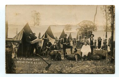 Orbost & District Historical Society
black and white photograph, July 27 1907
This is a camp of survey workers surveying the railway line . They were camped at Mossiface in 1907. It has been sent as a postcard - "Dear Miss Ross, Just a card, hoping you are well etc, trust you have not forgotten our trip. I forgot to get the name of the street in Hobart of Mr Benjamin or Temple?????? Sufficient. Yours sincerely H.R. Gordon". It has been dated September 30th 1907. There had been men surveying in East Gippsland from the late 19th century. Railway surveyors advocated two lines beyond Bairnsdale – one via Bruthen and the Tambo Valley to Omeo, the other via Swan Reach and Colquhoun to Orbost, then on to Bendoc and the border. With all the argument and feuding between the warring factions, by the end of 1891, the Parliamentary Railways Standing Committee gave up in despair of trying to reach any agreement and abandoned the idea altogether. Finally, with all problems solved, the first sod was turned at Mossiface on 9.1.1912, the government sticking to the original route in the 1890 survey .This is a pictorial record of a surveyors' camp in the early 20th century. The Bairnsdale to Orbost Railway was a significant contributor to the economy of Orbost until it closed.A black / white photograph / postcard of a group of men at a campsite. In the background is a row of tents. on the right side is a clothes line with several sheets hung over it. Two men are studying a map or chart; one man is sitting with a cloth around his shoulders while another is standing behind him cutting his hair; one man is washing cloth in a tin tub; another appears to be stirring a pot; others are sitting reading or just observing.on front - handwritten is " R.L.Y.S. SURVEY CAMP MOSSIFACE 27.7.07" on back is a letter - "Dear Miss Ross.............yours sincerely ????? Gordon"surveying-railway east-gippsland-railway mossiface-survey-camp