Showing 3211 items
matching road maps
-
 Heidelberg Golf Club
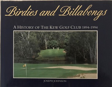
Book, Kew Golf Club, Birdies and billabongs: a history of the Kew Golf Club 1894-1994, 1994
A history of the first 100 years of Kew Golf Club in Belford Road, East Kew, founded in 1894.206 p., illus. (some col.), maps.non-fictionA history of the first 100 years of Kew Golf Club in Belford Road, East Kew, founded in 1894.golf clubs - kew, golf clubs - history, kew golf club -
 Heidelberg Golf Club
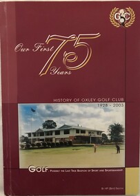
Book, Oxley Golf Club, Our first 75 years: history of Oxley Golf Club 1928-2003, 2003
A history of Oxley Golf Club, Oxley, Queensland, founded 1928.140 p., illus. (some col,), maps.non-fictionA history of Oxley Golf Club, Oxley, Queensland, founded 1928.golf clubs - history, golf clubs - queensland, oxley golf club, -
 Merri-bek City Council
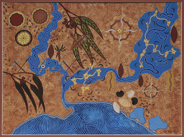
Acrylic on watercolour paper, Mandy Nicholson, Cultural Map of Melbourne, 2003
Primarily a painter, Mandy Nicholson also produces ceramics, carvings, murals, prints, designs and children’s clothing. Born in 1975, Nicholson was raised in Healesville and belongs to the Wurundjeri-willam (Woiwurrung language) clan of the Kulin Nation. Mandy’s paintings often represent important cultural rituals and are executed in her distinct graphic style using the traditional motifs of her people blended with contemporary interpretation. Cultural Map of Melbourne shows significant sites across Melbourne. These include scar trees, corroboree trees, stone quarries, bush tucker sites, significant rivers, fresh water wells and traditional campsites. -
 Merri-bek City Council
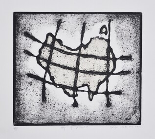
Work on paper - Collograph on Chine colle, George Matoulas, Map of Australia, 2009
... Merri-bek City Council 233 Sydney Road Brunswick melbourne ... -
 Ringwood and District Historical Society
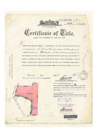
Document, Certificate of Title - W.G. Carter, Grandview Grove, Warranwood, Victoria, (later Bemboka Road) - part of Crown Section Twenty, Parish of Warrandyte, County of Evelyn - 1947
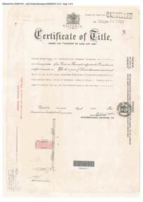
A4 copies of Landata Victoria Historical Search documents - Vol 7052 Fol 1410222. Includes Carter Family Tree property notes. William George Carter of Grandview Grove Ringwood, Nurseryman, is now the proprietor - three acres or thereabouts shown on map (12202a) - 14th March, 1947. Transfer B284834 Registered 21 September, 1961 - 1 acre shown on map (12202c) north of Plymouth Road. NOTES ON GRANDVIEW GROVE PROPERTY (Carter Family Tree extract) The Grandview Grove property was purchased by William (Bill) and Doreen Carter in 1947 as three acres of uncleared bushland. They had a 2 bedroom fibro-cement house built on the land which they informally called "Willoreen". With Doreen looking after sons Peter (born in 1940) and Robin (born in 1950), Bill worked locally at Croydon Dairy. The family spent much of their spare time clearing the land, where Bill then grew and sold fruit, flowers and berries, particularly strawberries, as a hobby and to supplement their income. Bill continued to do so while Peter and Robin were growing up, and after Doreen died in 1958. In 1961 Bill sold one of the three acres to one of his seven sisters, Grace, who lived in Kew but later moved to Rosebud and sold the land without ever building on it. During the 1960s, Grandview Grove was renamed Bemboka Road. After retiring as a milkman, Bill moved to Rosebud, Vic, and in 1977, sold the property to the Anglican Church, who were looking to invest in the site in anticipation of proposed future residential development in the area. As nearby properties were subdivided during the 1980s, the house, which the Church had initially utilised as low-cost family accommodation, was modified internaly to become a church/Sunday school. By the early 2000s, construction of a contemporary-design church and carparking area between the house and street alignment had been completed but the house remained as a detatched meeting room until falling into disrepair and was eventually demolished around 2010. -
 Melbourne Tram Museum
Letter (Collection), Melbourne & Metropolitan Tramways Board (MMTB), Extension of Burke Road line from Malvern Road, 1926 to 1938
... and quarto sheets typed with maps. Extension of Burke Road line from ...Melbourne and Metropolitan Tramways BoardRecord of correspondenceLetters in date orderDetails correspondence both internal and external with Councils and others about the possibility of extending the Burke Road line from the corner of Malvern Road along Waverley Road to Dandenong Rd, some 1.5miles. Has a small hand drawn map showing the various possibilities.tramways, new track, burke road, extensions, malvern, correspondencetramways, new track, burke road, extensions, malvern, correspondence -
 Healesville Sanctuary Heritage Centre
Newspaper, Mobil Road Guide, Mobil Road Guide to the Sir Colin MacKenzie Sanctuary Healesville, 1950
Map and description of some animals in Sanctuary.Photocopynon-fictionMap and description of some animals in Sanctuary.1950s -
 Bendigo Military Museum
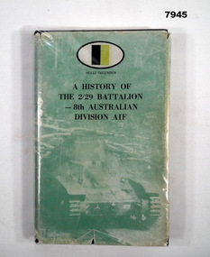
Book - BATTALION HISTORY WW2, 2/29 Battalion AIF Association/1983", "A HISTORY OF THE 2/29 BATTALION - 8th AUSTRALIAN DIVISION AIF", 1983 First Edition
Refer Cat No. 7944. Item in the collection of "Arthur E. Tranter". V50166 - VX52843 2/29th Bn. P.O.W.Hard cover book with dust cover. First Edition Book. Hard cover - cardboard, black colour buckram adhered cover. Dust cover - paper, with black print on front and spine. Cover ilustration - muted green colour tones of a tank and roadblock - "Muar Road Battle". Plastic cover - clear soft plastic - protective cover with adhesive tape. 224 pages, cut, plain white paper. Illustrated with black and white photographs and maps. A number of pages have handwritten notes in grey lead pencil and blue ink pen. P.186 has an added note on paper. Handwritten owner's name front end paper. Page 186 - note on paper, blue ink pen. "P.186/ This section by R.F. Nelson/ describes my experience/ fairly well./ I was with him throughout the whole/ term of imprisonment". Front end paper - handwritten owner's name - blue ink pen "Arthur E. Tranter/ 24-4-83".plublications, book, 2/29 battalion, ww2, arthur e tranter -
 Stawell Historical Society Inc
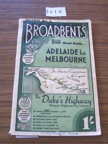
Book, Broadbent directory, Broadbent's Official : Speedo Strip Road Guide, 1943
Maps and descriptions of towns on the Western Highway & Dukes Highway from Melbourne to Adelaide. Sponsored by R.A.C.V and The Victorian Government Tourist BureauCream paper cover back border with green filling with a map from Melbourne to AdelaideBroadbeants Official Speedo Strip guide Melbourne to Adelaidestawell transport -
 Ringwood and District Historical Society
Document, Certificate of Title - Harold Claude Howship, Nurseryman, Ringwood, Vic. - 1928
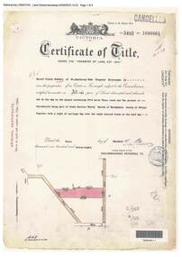
... roads coloured brown. Subdivision map includes Wonga Road (later... roads coloured brown. Subdivision map includes Wonga Road (later ...A4 copies of Landata Victoria Historical Search documents - Vol 5485 Fol 1096804. Harold Claude Howship of Mt. Dandenong Road Ringwood, Nurseryman, is now the proprietor of an Estate in Fee-simple subject to the Encumbrances notified hereunder ... 5 acres 3 roods 10 perches or thereabouts, part of Crown Section Twenty, Parish of Warrandyte, County of Evelyn, together with a right of carriage way over roads coloured brown. Subdivision map includes Wonga Road (later Warranwood Road), Grandview Grove (later Bemboka Road), and Plymouth Road, Ringwood. Proprietors and Transfers include Emily Mills, Plymouth Road Ringwood, Widow - 27th January, 1939. William George Carter, Grandview Grove Warranwod - 14th March, 1947 - 3 acres Evelyn Goudie and Beverley Gwen Goudie, Wonga Road Warranwood - 23rd October, 1950 - 1 acre -
 Ringwood and District Historical Society
Document, Certificate of Title - Harry Temple Marshall, Wesburn Farmer, Vic. - part of Crown Section 20, Parish of Warrandyte, County of Evelyn - 1928
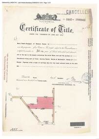
... with a right of carriage way over roads coloured brown. Subdivision map... with a right of carriage way over roads coloured brown. Subdivision map ...A4 copies of Landata Victoria Historical Search documents - Vol 5485 Fol 1096803. Harry Temple Marshall is now the proprietor of an Estate in Fee-simple subject to the Encumbrances notified hereunder ... 10 acres 3 roods 10 perches or thereabouts, together with a right of carriage way over roads coloured brown. Subdivision map includes un-named roads - western side is Wonga Road (later Warranwood Road), and eastern side is Grandview Grove (later Bemboka Road), both north of Plymouth Road, Ringwood, Vic. Transfers include Harold Claude Howship, 1st December, 1928 James Bell McAlpin, 26th March, 1939. -
 Flagstaff Hill Maritime Museum and Village
Map - Survey Map, F.F. McGovern, Yangery - County of Villiers, 1884
A surveyor was employed to measure the land designated as Yangery, County of Villiers, in the Borough of Warrnambool. The area on the map is similar to the earlier Farnham Survey undertaken by William Rutledge in the 1850's. Warrnambool was a Borough between 1863-1883. Coutours, waterways, sea and other significant points are shown. The distances are accurately measured. This survey map was used for planning future land sales, recreation areas and roads. WILLIAM RUTLEDGE (1806-1876) William Rutledge surveyed the land known as Farnham in southwest Victoria in 1843. His tenants made him a profitable business from working the land there. In 1863 Rutledge moved from nearby Port Fairy to Farnham and became very successful in breeding sheep, which he imported from J.R. Kirkham of Lincolnshire, England. He also bred horses on his land. The survey map of Yangery is important for its connection with renowned surveyor William Rutledge. The map shows the growth of landholders in the district when compared to the original Rutledge survey of the 1850's.Survey map of Yangery, titled "Yangery - County of Villiers". Printed on white paper, mounted on brown paper. c. 1863-1876. Comments printed on the Map include; Special Survey by William Rutledge, Photo-lithographed at the Department of Lands and Survey, Melbourne by W.J. Burson, Price 1/- [one shilling]. Scale is in Chains. Map has boundaries of Koroit Borough, Meerai, Purnim, Wangoom, Borough of Warrnambool, Mentions the Proposal of Tower HIll for Public Recreation. The map names the owners of the land at that time. Hand written pencil marks and figures and "Sauls fence" drawn on map. Hand written pencil markes and figures and "Sauls fence" drawn onto map. "For Department Use only". "Scale: 8 chains to 1 inch" flagstaff hill, warrnambool, shipwrecked-coast, flagstaff-hill, flagstaff-hill-maritime-museum, maritime-museum, shipwreck-coast, flagstaff-hill-maritime-village, county of villiers map, yangery district, w.j. burson, borough of warrnambool, koroit, purnim, meerai, wangoom, proposal of tower hill for public recreation, special survey by william rutledge, william rutledge, farnham, lincolnshire sheep, clydesdale -
 Ringwood and District Historical Society
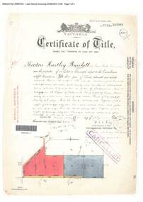
Document, Certificate of Title - Theodore Hartley Burchett - part of Crown Section 20, Parish of Warrandyte, County of Evelyn - 1911
... . Subdivision map includes un-named roads - lower western side is Wonga.... Subdivision map includes un-named roads - lower western side is Wonga ...A4 copies of Landata Victoria Historical Search documents - Vol 3520 Fol 703991.Theodore Hartley Burchett of Lara Lake, Farmer, is now the proprietor of an Estate in Fee-simple subject to the Encumbrances notified hereunder ... 180 acres 01 rood 27 perches or thereabouts, being lots 1, 8, 9 and 10 on plan of subdivision no.4315. Subdivision map includes un-named roads - lower western side is Wonga Road (later Warranwood Road), and eastern side is Grandview Grove (later Bemboka Road), both north of Plymouth Road, Ringwood, Vic. Transfers include Anna Maria Wicks and Henry James Trowbridge, 3rd October, 1911 Elizabeth Ann Walden, 18th September, 1912 - 28ac 3rds 5per. Edward Thomas Miles, 22nd September, 1913 - 27ac 19per. Samuel Styles, 10th October, 1916 - balance. -
 Ringwood and District Historical Society
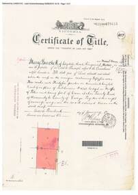
Document, Certificate of Title - Mary Burchett, Lilydale Road, Ringwood - part of Crown Section 20, Parish of Warrandyte, County of Evelyn - 14th January, 1910
... . Subdivision map includes un-named road - Grandview Grove (later.... Subdivision map includes un-named road - Grandview Grove (later ...A4 copies of Landata Victoria Historical Search documents - Vol 3398 Fol 679415.Mary Burchett of Lilydale Road, Ringwood, Married Woman, is now the proprietor of an Estate in Fee-simple subject to the Encumbrances notified hereunder ... 55 acres 3 roods 35 perches or thereabouts, being lots 8 and 9 on plan of subdivision no.4315. Subdivision map includes un-named road - Grandview Grove (later Bemboka Road, Warranwood, Vic). Title transferred to Theodore Hartley Burchett, 27th July, 1911. -
 Warrnambool and District Historical Society Inc.
Booklet - Booklet Collection: City of Warrnambool Tourist Guides, Collett, Bain and Gaspar, Warrnambool
This is a collection of sixteen tourist guides dating from the mid 1970's to 2013. These contain listings of businesses, accommodation, eateries and events in Warrnambool and district. They also include maps of Warrnambool and surrounds, advertising and photographs of various attractions. While mainly covering Warrnambool a small number of the guides cover the South West Region. These directories have mainly been published by the Warrnambool City Council and are a selection of the types of information provided to visitors at the Tourist information centre during this time period.These tourist guides give snapshots of the City of Warrnambool for the years covered and will be useful for research.[.1] An 8 page paper booklet with black printing and a black & white photo of the pond at the Botanical Gardens on the front cover. [.2] two photocopied A4 black and white pages from the book "On the Trail" K Winser 1956 (Main Roads of Australia) [.3] A trifold colour brochure with a stylised map of the coast on the yellow and blue front cover. The inside has stylised colour drawings on Warrnambool attractions. The rear cover has coloured photographs of bush, Liebig Street and Fletcher Jones gardens [.4] A trifold black and white brochure with a black line drawing of a whale on the front cover. [.5] A trifold white card with mauve printing. The front cover has a line drawing of the former Timor Street post office and a map of businesses and landmarks in Timor Street. The reverse side contains a brief history of Warrnambool. [.6] A 98 page stapled booklet with a foreword by Vanda Savill. There are 4 pages of coloured photographs. The remainder are black and white photographs. The front cover is purple with white writing in the lower third. There is an outline of the coast and five colour photographs of district attractions. The inside middle page has a map of the Western wonderland region. The content covers towns in this area. Content relating to Warrnambool is in the last six pages. [.7] Twelve loose photocopied black and white pages. The front cover has the Warrnambool Premier Town 1988-1991 logo and a photo of a Southern Right Whale and calf. The bottom right hand corner has a Standard Warrnambool logo. [.8] 44 page booklet printed with blue ink. The staples have been removed. The glossy front cover has blue printing with a coloured photo of Flagstaff Hill Maritime Village pond. The centre pages has a fold out map of the City of Warrnambool. The rear cover has photos of The Twelve Apostles and Hopkins Falls. [.9] 4 loose photocopied pages with Warrnambool Library and Corangamite Regional Library Service Warrnambool City Library black ink stamps. The front page line drawing illustrations of Warrnambool attractions [.10] A single sheet of glossy white paper folded in half to make four pages. The front page has a Warrnambool premier town logo 1979-1982 and blue printing and a visitor survey. [.11] A conference pack of light card folded to make a pocket containing three brochures, a shipwreck coast tourist directory and a Australian Heritage Parks Association conference program dated 24 to 27 May 1992. The front cover of the pack has green writing over a stylised upward arrow. There is a City of Warrnambool logo in the top right hand corner and two film strips diagonally across the cover containing photographs of Warrnambool. The rear cover has a coloured Warrnambool Premier Town logo. [.12] A 63 page stapled booklet with coloured photographs of Warrnambool. The front cover has black writing on white background. There is a coloured photograph of Flagstaff Hill in the middle of the cover and a Warrnambool City and Visit Victoria logos on the lower edge. The middle pages has a coloured of the city of Warrnambool with an inset map of Allansford. [.13] A single large sheet of white paper folded in ten to make a brochure. The front cover has black printing. The rear cover has a purple ink stamp for the City of Warrnambool Tourist Information Centre. When folded out the reverse side has a green, grey and white map of the South West Region of Victoria. [.14] A 48 page colour booklet on glossy paper. The front cover has white writing on a blue background and includes photographs of the Twelve Apostles, the Promenade walk, Flagstaff Hill and a southern right whale's tail. The rear cover has photographs of The Twelve apostles, a passenger train from Melbourne passing the Lake Pertobe playground, and a rural scene. There is white writing and a white Warrnambool City logo on a blue background. The centre pages have a stylised green and blue map of the city of Warrnambool. [.15] A 48 page colour booklet on glossy paper. The front cover has white writing over colour photographs of two people at a lookout, Flagstaff Hill, three southern right whales and a child at the Lake Pertobe playground. The lower edge has blue upper case writing on a white background. The rear cover has a colour photograph of the Twelve Apostles. The lower white border on the rear covers has a a blue and green City of Warrnambool logo and blue writing. The centre pages have a stylised green and blue map of the city of Warrnambool. [.16] A 64 page colour booklet on glossy paper. The front cover has black writing on a black background and there is a photograph of a southern right whale's tail. The lower edge has the Warrnambool City and Visit Victoria Logos. The centre pages have maps of Warrnambool and surrounds. [.1] This week in Warrnambool Vol 2 No. 5 Thurs 1st Feb. For the time of your life [.2] Warrnambool Way [.3] Warrnambool The Holiday Host on the South West Coast with compliments City of Warrnambool and Warrnambool Chamber of Commerce [.4] MMI Insurance presents Whales Giants of the Deep Whale Watcher's Logbook Warrnambool [.5] Warrnambool History began in Timor Street [.6] Western Wonderland Tourist Association [.7] A Premier Arrow Tour of Warrnambool Victoria's Premier Town Australia's Southern Right Whale Nursery [.8] Warrnambool The Heart of Victoria's Great Southwest Visitor's Handbook [.9] What to see in Warrnambool Victoria's Premier City 1979-1982 [.10] Win a Free Holiday & $200 Cash in Victoria's Premier Town [.11] Advancing Warrnambool together! [.12] Great Ocean Road Warrnambool Official Visitor Guide [.13] Tourist guide to the South West Region Victoria All it needs is you [.14] Warrnambool visitor guide 2005 the great ocean road experience attractions accommodation entertainment dining [.15] Warrnambool Visitor Guide 2006 the great ocean road experience Attractions Accommodation Entertainment Dining [.16] Official Visitors' Guide Warrnambool Victoria Australia Discover the Great Ocean Road warrnambool, warrnambool tourist guides -
 Ringwood and District Historical Society
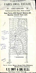
Flyer, Residential Land Sale Sub-division - Fairy Dell Estate, Warranwood, Vic. - circa 1950s
Land sale advertisement for 50 home sites with map of Sub-division showing layout of streets and allotments, summary of local features and services and terms of sale, and copy of sectional map of Crown Allotments 20 & 21B Parish of Warrandyte also showing layout of Sub-division.Subdivision includes Grandview Grove (later Bemboka Road), Merrill Crescent and Kerry Road, Warranwood. Estate Agents - V.C. Swift & Son R.E.S.I., Main Street, Croydon, Phone 20. Solicitors - Morgan, Fyffe & Mulkearns, 108 Queen Street, Melbourne. Handwritten 1970s real estate price notations for some blocks. -
 Federation University Historical Collection
Map, Ballaarat Gold Field, 1861, 1861
A party of surveyors camped by Yuille's Swamp (later Lake Wendouree) and surveyed the countryside for a map to be produced by the Geological Survey of Victoria. In November 2004 the Central Highlands Regional Library presented a special edition of 200 copies of the 1861 map reproduced from a copy in their collection. Original 1861 map of Ballarat showing streets and leads. Blue dots indicate gold leads, and red lines indicate auriferous quartz reef and outcrops of quartz veins."Compiled & Drawn from the Survey of Mining Surveyors Davidson, Fitzpatrick and Cowan & the Plans in the Surveyor General's Office by J. Brahe, 21st October 1861. R. Brough Smyth, Secretary for Mines. The Honourable J.B. Humffray, M.L.A. Commr of Mines.”ballarat, map, ballarat east, lake wendouree, survey, mines, robert davidson, ballarat gold field 1861, yuille's swamp, wendouree swamp, little bendigo diggings, gold leads, old post office hill, specimen hill, bakery hill, black hill, dead horse creek, brown hill, pennyweight hill, clayton hill, soldiers hill, golden point, gum tree flat, white flat, poverty hill, chinese village, robert brough smyth, ballarat map 1861, ballaarat vineyard, dead horse gully, deadhorse creek, invermay, black hill flat, gaelic church, police reserve, magpie range, dalton's flat, caadian lead, rifle butts, powder magazine, bathing house, government camp, gold office, chinese, llanberrris, victoria theatre, charlie napier hotel, united states hotel, grape's hoel, clayton's hill, cattleyard hill, free trade hotel, esmond lead, bakery hill, black hill lead, juvenile reformatory, ballarat orphanage, lady barkly lead, triffet's slaughter yard, little bendigo, melbourne road, t. cowan, thomas cowan -
 Bendigo Historical Society Inc.
Document - MCCOLL, RANKIN AND STANISTREET COLLECTION: INDENTURE, GOLD MINING LEASE 11081 CROWN AND HERBERT JACKSON LEED OF BENDIGO, 21st September, 1940
6-page document plus map, dated 21st September 1940, between the Crown and Herbert Jackson Leed, for the land shown on the accompanying map 'indicated by yellow colour' Depths indicated on lease document. On map: Mining District of Bendigo, County of Bendigo, Parish of Sandhurst. No. 11081. Net Area 24 acres, 3 roods, 3 perches. Signed by Herbert Leed and ?Walsh, Warden Clerk, Bendigo. Map shows lease holding 11081 coloured yellow. Other leases: no's. 9882 11081, 11034, 11080. Streets: Fletcher Street, and Belle Vue Road. Gullies: Derwenters Mistake Bully and Pig Face Gully on lease 11081. Quarry Hill Recreation Reserve marked and some residential allotments. Water race indicated on map. On back of document: ; Deborah United Gold Mining Company No Liability of Charing Cross Bendigo is now the proprietor of the within described estate by transfer registered on 21st November 1940 and numbered 1795202.bendigo, mining, deborah united gold mine, herbert jackson leed, deborah united gold mining. major general sir winston joseph dugan -
Melbourne Tram Museum
Letter (Series), Melbourne & Metropolitan Tramways Board (MMTB), Darling and Koornang Road extensions from Carnegie, 1937
... sheets typed with a sketch map. Darling and Koornang Road ...Melbourne and Metropolitan Tramways BoardRecord of correspondenceLetters in date orderDetails correspondence both internal and external with Councils about a possible tram line along Waverley Road, Darling Rd, Koornang Rd to the the Carnegie tram terminus in Trugannini Road. Inlcudes cost estimate, and sketch plan.tramways, new track, extensions, correspondence, darling road, carnegie, koornang rdtramways, new track, extensions, correspondence, darling road, carnegie, koornang rd -
 Bendigo Historical Society Inc.
Document - RALH BIRRELL COLLECTION: OLD MINING SITES WHITE HILLS, Dr. Ralph Birrell (now deceased)
4-page typed document, prepared by Dr. Ralph Birrell, on the significance of the former mining sites on the White Hills. Document describes the 'area adjacent to the old Railway Workshops as shown on attached map'. A further addition (slip of paper, typed) to the paper describes the location of the Whiter Hills of White Hills: 1st White Hill is east of Lake Weeroona The 2nd and 3rd White Hills are around Strickland Road, former East Bendigo Primary School, Baden/Powell Streets The 4th and 5th White Hills are east of Napier and Grace Street The 6th White Hill is east of Plumridge Street The 7th White Hill is east of Bosquet Street. -
 Whitehorse Historical Society Inc.
Map - Civic Map, Subdivision of Village of Springfield, 1861
... of Maps in the LaTrobe Library. Springfield Estate Whitehorse Road ...Map of the subdivision of the Springfield Estate, Nunawading, 1861. The Springfield Estate was located in the Northwest corner of Whitehorse Road and Springvale Road.Map of the subdivision of the Springfield Estate, Nunawading, 1861. Springfield Estate was located in the Northwest corner of Whitehorse Road and Springvale Road.non-fictionMap of the subdivision of the Springfield Estate, Nunawading, 1861. The Springfield Estate was located in the Northwest corner of Whitehorse Road and Springvale Road.springfield estate, whitehorse road nunawading, springvale road nunawading -
 Ringwood and District Historical Society
Document, Certificate of Title - Thomas Arthur Wentworth Burkitt - part of Crown Section 20, Parish of Warrandyte, County of Evelyn - 5th June, 1929
... maps includes Brysons Road, Warrandyte Coach Road (later Wonga... maps includes Brysons Road, Warrandyte Coach Road (later Wonga ...A4 copies of Landata Victoria Historical Search documents - Vol 5598 Fol 1119416.Thomas Arthur Wentworth Burkitt of Box Hill, Retired Clerk of Courts, is now the proprietor of an Estate in Fee-simple subject to the Encumbrances notified hereunder ... 35 acres 1 rood 11 perches or thereabouts, together with right of carriage way over part of Warrandyte Coach Road on plan of subdivision no.12040. Subdivision maps includes Brysons Road, Warrandyte Coach Road (later Wonga Road), Rangeview Parade (later Omeo Parade), and Kardinia Crescent, Warranwood. Mortgages and Transfers include Mortgate - part to the Trustees of Vic District no.82 I.O.O.R, 1st August, 1929, Mortgate - part to Arthur Edward Perry, 1st August, 1929, Transfer 1426692 - George Clements Dickason and Will Gordon Sprigg, 20th August, 1929, Transfer 1766662 - Linda Elizabeth Collins, 28th March, 1940. -
 Melbourne Tram Museum
Ephemera - Tram Route Guide, Metlink, 2005
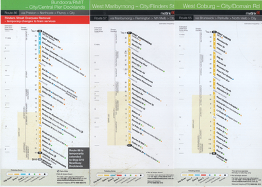
Route guides for route 55 (West Coburg - Domain Road), route 47 (West Maribyrnong) and route 86 (Bundoora - Central Pier) which has a note about the Flinders St overpass removal in 2005. See item 1253 for details and associated route guides. Has the logos of Yarra Trams, Metlink and Metcard.Demonstrates Metlink / Yarra trams route guides.Set of 3 DL pamphlets - full colourtramways, timetables, maps, route 57, route 55, route 86 -
 Bendigo Historical Society Inc.
Map - LONG GULLY HISTORY GROUP COLLECTION: MAP OF LONG GULLY/CALIFORNIA GULLY AREA
BHS CollectionTwo copies of a map, printed on yellow paper, of the Long Gully/California Gully Area. It shows Eaglehawk Road from Craig Street then Mr Korong Road,to the Murray Valley Highway to just past Avenue Street. Sandhurst Road and Holmes Road are to the right. To the left is California Gully Road. Water Supply Purposes Reserve, Mental Hygiene Authority, Comet Hill State School Reserve, Agricultural Showgrounds and Recreation Reserve, Rubbish Reserve and two un-named State Schools are shown. Some contours are also shown.bendigo, history, long gully history group, the long gully history group - map of long gully/california gully area -
 Bendigo Historical Society Inc.
Map - LONG GULLY HISTORY GROUP COLLECTION: MAP OF LONG GULLY AREA
BHS CollectionTwo copies of a map, printed on yellow paper, of the Long Gully Area. It shows Eaglehawk Road from Barnard Street to a little past William Street.bendigo, history, long gully history group, the long gully history group - map of long gully area, victorian water supply reserve, borough of eaglehawk -
 Melbourne Tram Museum
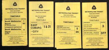
Ephemera - Timetables - Metropolitan Transit - set of 22, Metropolitan Transit Authority (MTA), 1983 and 1984
Timetables - provides information on fare sections and a route map. 1 - Routes 1, 2 & 4 - South Melbourne - City - July 1984 2 - Route 1 & 21 - East Coburg - City August 1983 3 - Route 5 and 35 - Malvern Burke Road - July 1984 4 - Route 3 and 377 - East Malvern (Darling Road) and bus route on Sundays only - Jan. 1984 5 - Route 6, 36 and 7 - Glen Iris - July 1984 6 - Route 8 and 38 - Toorak - June 1984 7 - Route 9 and 14 - Northcote - June 1984 8 - Route 10 & 11, 13 - West Preston - May 1984 9 - Route 15 & 22 - Moreland - July 1983 10 - Route 15 & 16, 53 & 55 - St Kilda Beach - July 1983 11 - Route 19, 20 and 18 (MMTB) - North Coburg - Oct. 1982 12 - Route 42, 23, 44, 45 and 47 - Mont Albert - July 1984 13 - Route 48, 24, 40, 41 and 29 - North Balwyn - Nov. 1983 14 - Route 57, 357, 54, 60, 58 and 50 - West Maribyrnong - bus on Sundays - July 1984 15 - Route 64, 65, 62 and 61 - East Brighton - Jan. 1984 16 - Route 67, 37, and 66 - Carnegie - Jan. 1984 17 - route 70, 71 and 76 - Wattle Park - June 1984 18 - route 75, 74, 76 and 28 - East Burwood - JIan. 1984 19 - route 77, 78 and 79 - Prahran - North Richmond - July 1984 20 - route 82 and 223 - Footscray - Moonee Ponds and bus on Sundays and Saturdays - June 1984 21 - route 88, 14, 89 and 90 - East Preston - July 1983 22 - route 96, 95 and 97 - East Brunswick - July8 1984Yields information about Metropolitan Transit services during the mid 1980s.Set of 22 Metropolitan Transit tram timetables - multifold printed on yellow paper.timetable, metropolitan transit, the met, route 1, route 2, route 4, route 21, route 5, route 35, route 3, route 377, route 6, route 36, route 7, route 8, route 38, route 9, route 14, route 10, route 11, route 13, route 15, route 22, route 16, route 53, route 55, route 19, route 18, route 20, route 42, route 23, route 44, route 45, route 47, route 48, route 24, route 40, route 41, route 29, route 57, route 357, route 54, route 60, route 58, route 50, route 64, route 65, route 62, route 61, route 67, route 37, route 66, route 70, route 71, route 76, route 75, route 74, route 28, route 77, route 78, route 79, route 82, route 223, route 99, route 89, route 90, route 96, route 95, route 97 -
 City of Kingston
Pamphlet - Colour, Arthur Tuckett & Son, Auctioneers and Subdivisional Specialists, Auction of Station Estate, Moorabbin, 1923
Sales plan for land in the suburb of Moorabbin, bounded by Railway Crescent, South Road, Jasper Road and Pattersons Road.The developing urban area of Moorabbin within the City of Kingston. This land sale pamphlet illustrates the subdivision of land within the municipality and the changing demographic of the district as new houses are constructed.Colour pamphlet advertising an auction of the Station Estate Moorabbin. Incorporates details of the shopping facilities, proximity to the railway line, variety of schools and churches in the area, and a sales plan for home sites and shop fronts. Incorporates a map of the estate bordered by Pattersons Road, Japer Road, South Road and Railway Crescent. Handwritten in grey pencil top right front page: Station Estate / late [indecipherable] Handwritten in red pencil on subdivision map: x [on majority of properties marked on the map] Handwritten in grey pencil on subdivision map: additional subdivisions drawn in and large lines drawn across the mapmoorabbin, land sales, estate -
University of Melbourne, Burnley Campus Archives
Map, Drainage & Contours City of Hawthorn, c. 1970
Copy of map with some coloured and pencil annotations. Scale 1:2000. Marked "2". Area bounded by Glenferrie Road, Power Street, Barkers Road, Burwood Roadhawthorn, glenferrie sports ground, grace park, contours -
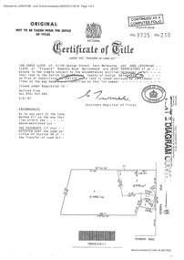 Ringwood and District Historical Society
Document - Certificate of Title and Maroondah Heritage Study, "Elouera", 59 Bemboka Road, Warranwood, Victoria, previously part of Crown Section 20, Parish of Warrandyte, County of Evelyn - 4th February, 1987
... no.204137B shown on the map. Subdivision includes Bemboka Road... shown on the map. Subdivision includes Bemboka Road. Encumbrance ...Property subsequently subdivided into residential allotments with formation of Aspen Court, Warranwood, circa 2010.A4 copies of Landata Victoria documents - Vol 9725 Fol 210 derived from Vol 9701 Vol 469, and 2-page Heritage Study report.Ian Vance Lloyd and June Josephine Lloyd are joint proprietors of an estate in fee simple - Lot 4 on Plan of Subdivision no.204137B shown on the map. Subdivision includes Bemboka Road. Encumbrance E-1 later extended through Lot 4 as Aspen Court. Transfer - Proprietor June Josephine Lloyd - 29 July, 1993. Documents include 2-page Heritage report for study conducted prior to subsequent Aspen Court residential development circa 2010. -
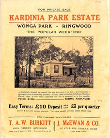 Ringwood and District Historical Society
Flyer, Land Sale Brochure, Kardinia Park Estate, North Ringwood, Vic. - circa 1948
Folded buff-coloured land sale advertisement for Kardinia Park Estate in Warranwood area of North Ringwood, including terms of sale, area map, layout plan of the estate, and summary of local facilities and services. Front page features photograph of a man and dog in front of a house captioned as Lot 1 on four acres shown on the estate layout as cnr of Brysons Road and Range View Parade (later Omeo Parade). Second page includes bushland swimming pool photograph and promotional information for prospective buyers.Subdivision includes Kardinia Crescent, Wonga Road, Brysons Road, Range View Parade (later Omeo Parade), Motor Coach Road (later Wonga Park Road, then Warranwood Road). (Agent/s) T.A.W. Burkitt, Main Street, Ringwood, Phone (9 to 6) Ringwood 242, Evenings, Ringwood 157, and J. McEwan & Co, 317 Collins Street, Melbourne, Phone 6750 Central.